


Chapter 18.25
GENERAL POLICIES AND REGULATIONS
Sections:
18.25.010 General policies and regulations – Intent.
18.25.020 Archaeological, historic, and cultural resources.
18.25.030 Flood hazard reduction.
18.25.060 Scientific and educational activities.
18.25.070 Shoreline ecological protection and mitigation.
18.25.080 Shoreline restoration and enhancement.
18.25.100 Vegetation conservation.
18.25.010 General policies and regulations – Intent.
Based on the governing principles of the SMP Guidelines, the following policies and regulations apply to all uses, developments, and activities in the shoreline areas of the City, regardless of whether or not a permit is required. General policies and regulations are broken into different topic headings and arranged alphabetically. Topics begin with descriptions of their intent and/or applicability, followed by general policy statements and regulations that are more specific. The intent of these provisions is to be inclusive, making them applicable to all environments, as well as particular shoreline uses and activities. These policies and regulations are to be used in conjunction with the policies and regulations in Chapters 18.30 and 18.35 UPMC, and the administrative provisions, specifically including UPMC 18.15.070, Nonconforming development.
These provisions address the elements of an SMP as required by RCW 90.58.100(2) and implement the governing principles of the SMP Guidelines as established in WAC 173-26-186.
(Ord. 652 § 1 (Exh. A), 2015).
18.25.020 Archaeological, historic, and cultural resources.
A. Applicability. The following provisions apply to archaeological and historic resources, which may include sites, buildings, structures, districts, or objects, that either are recorded at the Washington State Department of Archaeology and Historic Preservation (DAHP) and/or by local jurisdictions or have been inadvertently uncovered. Archaeological sites located both in and outside the shoreline jurisdiction are subject to Chapter 27.44 RCW (Indian Graves and Records) and Chapter 27.53 RCW (Archaeological Sites and Records) and development or uses that may affect such sites shall comply with Chapter 25-48 WAC as well as the provisions of this Shoreline Program.
B. Policies.
1. The destruction or damage to any site having any archaeological, historic, cultural, scientific, or educational value as identified by the appropriate authorities, including affected Indian Tribes, and the State Department of Archaeology and Historic Preservation (DAHP), should be prevented.
2. Ensure that new development is designed to avoid damaging significant archaeological and historic resources and enhance and/or be compatible with such resources.
C. Regulations.
1. Developers and property owners shall immediately stop work and notify the City, the DAHP and affected Native American tribes if archaeological resources are uncovered during excavation.
2. A site inspection or evaluation by a professional archaeologist in coordination with affected Native American tribes shall be required for all permits issued in areas documented to contain archaeological resources. Failure to comply with this requirement shall be considered a violation of the shoreline permit.
3. Significant archaeological and historic resources shall be preserved permanently for scientific study, education and public observation. When the City determines that a site has significant archeological, natural scientific or historical value, a shoreline substantial development permit and/or any other permit authorizing development or land modification shall not be issued which would pose a threat to the site. The City may require that a site be redesigned or that development be postponed in such areas to allow investigation of public acquisition potential, potential for adaptive new uses or management practices, retrieval and preservation of significant artifacts, or another course of action appropriate for the location and circumstances.
4. In the event that unforeseen factors constituting an emergency as defined in RCW 90.58.030 necessitate rapid action to retrieve or preserve artifacts or data identified above, the project may be exempted from the notification and evaluation regulations, above. The City shall notify Ecology, the State Attorney General’s Office and the DAHP of such a situation in a timely manner.
5. Archaeological sites located both in and outside the shoreline jurisdiction are subject to Chapter 27.44 RCW (Indian Graves and Records) and Chapter 27.53 RCW (Archaeological Sites and Records) and shall comply with Chapter 25-48 WAC or its successor as well as the provisions of this Shoreline Program.
6. Park, open space, public access, and site planning shall consider identified historical or archaeological resources when designing and managing access to such areas in order to give maximum protection to the resource and surrounding environment.
7. Clear interpretation of significant archaeological and historic resources shall be provided through the use of signage or other improvements or facilities when and where appropriate.
(Ord. 652 § 1 (Exh. A), 2015).
18.25.030 Flood hazard reduction.
A. Applicability. The following provisions apply to actions taken to reduce flood damage or hazard and to uses, development, and shoreline modifications that could increase flood hazards. Flood hazard reduction measures can consist of nonstructural measures such as setbacks, land use controls, wetland restoration, relocation of uses, biotechnical measures, or stormwater management programs, and structural controls such as dikes, levees, revetments, bulkheads, floodwalls, channel realignment, or elevation of structures consistent with the National Flood Insurance Program.
B. Policies.
1. Where feasible, nonstructural flood hazard reduction measures should be given preference over structural measures.
2. Flood hazard reduction provisions should be based on applicable watershed management plans, comprehensive flood hazard management plans, and other comprehensive planning efforts, provided those measures are consistent with the SMA and this Shoreline Program.
3. Flood hazard reduction measures should not result in a net loss of ecological functions.
4. When evaluating flood control measures, the removal or relocation of structures in flood- prone areas should be considered.
5. Development and shoreline modifications that would result in interference with the process of channel migration and may impact property or improvements or result in a net loss of ecological functions should not be allowed.
C. Regulations.
1. New development or new uses in shoreline jurisdiction, including subdivision of land, shall not be established when it would be reasonably foreseeable that the development or use would require structural flood hazard reduction measures within the channel migration zone or floodway.
2. New structural flood hazard reduction measures in the shoreline jurisdiction shall be allowed only when it can be demonstrated by a scientific and engineering analysis that they are necessary to protect existing development, that nonstructural measures are not feasible, that impacts on ecological functions and priority species and habitats can be successfully mitigated so as to assure no net loss, and that appropriate vegetation conservation actions are undertaken consistent with WAC 173-26-221(5) and this Shoreline Program.
3. New structural flood hazard reduction measures shall be placed landward of the associated wetlands, and designated vegetation conservation areas, except for actions that increase ecological functions, such as wetland restoration. In order for such flood hazard reduction projects to be authorized, it must be determined that no other alternative is feasible to protect existing development. The need for and analysis of feasible alternatives to structural improvements shall be documented through a geotechnical analysis.
4. New structural public flood hazard reduction measures, such as dikes and levees, shall dedicate and improve public access pathways unless public access improvements would cause unavoidable health or safety hazards to the public, inherent and unavoidable security problems, unacceptable and unmitigable significant ecological impacts, unavoidable conflict with the proposed use, or a cost that is disproportionate and unreasonable to the total long-term cost of the development.
5. New development within a channel migration zone or floodway shall be limited to the uses and activities listed in WAC 173-26-221(3)(b) and (3)(c)(i). Removal of gravel for flood management purposes shall be consistent with an adopted flood hazard reduction plan and allowed only after a biological and geomorphological study shows that extraction has a long-term benefit to flood hazard reduction, does not result in a net loss of ecological functions, and is part of a comprehensive flood management solution.
6. The City’s flood damage prevention regulations, codified under UPMC Title 14, apply to areas of special flood hazards in the shoreline jurisdiction. Chapter 14.15 UPMC is herein incorporated into this SMP, except for the variance provisions contained in UPMC 14.15.030(D).
(Ord. 652 § 1 (Exh. A), 2015).
18.25.040 Parking.
A. Applicability. The following provisions apply to off-street parking located within shoreline jurisdiction.
B. Policies for Off-Street Parking Provided for Uses Other Than Detached Single-Family Dwellings.
1. Parking should be allowed within the shoreline jurisdiction only for approved uses listed in Table 18.30.A.
2. Parking for shoreline uses should be located in areas outside the shoreline jurisdiction, where feasible; otherwise parking should be located as far landward of the ordinary high water mark as feasible.
3. The use of low-impact construction methods, such as pervious pavement, should be encouraged and used to the extent practicable within the shoreline environment.
4. Parking should be designed and constructed to be compatible with adjacent uses and avoid impacts to the shoreline environment.
5. Walkways should be provided between parking areas and the buildings or uses they serve; walkways should be located as far landward of the ordinary high water mark as feasible.
6. The use of the variance process authorized in UPMC 19.60.130 to increase the number of parking stalls should be discouraged in the shoreline jurisdiction in order to minimize impervious surface.
7. Parking provided in excess of the maximum parking standards per UPMC 19.60.130 should be constructed of pervious pavement.
C. Policies for Off-Street Parking Provided for Detached Single-Family Dwellings.
1. Parking should be located as far landward of the ordinary high water mark as feasible.
2. The use of low-impact construction methods, such as pervious pavement, should be encouraged and used to the extent practicable within the shoreline environment.
3. Parking should be designed and constructed to avoid impacts to the shoreline environment.
D. Regulations for Off-Street Parking Provided for Uses Other Than Detached Single-Family Dwellings (See Figure 3 Below).
1. Parking facilities within the shoreline jurisdiction shall only be allowed to support an authorized use.
2. Parking provided as a stand-alone primary use, rather than in support of a primary use, is prohibited within the shoreline jurisdiction.
3. Parking facilities shall be located landward of the principal building, except when:
a. The parking facility is within or beneath the structure and adequately screened;
b. The City’s design standards or guidelines would encourage or require the parking facility to be located to the side of a principal building in order to encourage a pedestrian orientation for new development; or
c. An alternate orientation would have less adverse impact on the shoreline.
4. Over-water parking facilities are prohibited.
5. Parking facilities shall be designed and landscaped to minimize adverse impacts upon adjacent shorelines and abutting properties. Landscaping shall comply with Chapter 19.65 UPMC and the vegetation conservation standards in UPMC 18.25.100.
6. Parking facilities shall provide safe and convenient pedestrian circulation within the parking area to the building or use it serves, and shall be located as far landward of the ordinary high water mark as feasible.
7. Parking associated with boat ramps and other areas of shoreline access shall be located a minimum of 35 feet from the ordinary high water mark within the Day Island Medium Intensity Shoreline Environment and 50 feet from the ordinary high water mark in all other shoreline environments except when located within a public street right-of-way.
8. Parking provided in excess of the maximum parking standards per UPMC 19.60.130 shall be constructed of pervious pavement.
9. Parking facilities shall comply with the water quality development standards in UPMC 18.25.120.
FIGURE 3 – PARKING LOCATIONS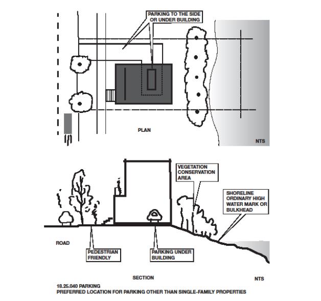
E. Regulations for Off-Street Parking Provided for Single-Family Dwellings (See Figure 4 Below).
1. Parking facilities within the shoreline jurisdiction shall only be allowed in conjunction with a single-family dwelling.
2. Detached garages, carports, driveways and other parking facilities shall be located outside of the VCA and landward of the waterward side of the dwelling.
3. To the extent feasible, attached garages and carports shall be designed and located to provide the most direct vehicular access from the street, minimize impervious driveway surface and minimize adverse impacts on the shoreline.
FIGURE 4 – SINGLE-FAMILY PARKING LOCATIONS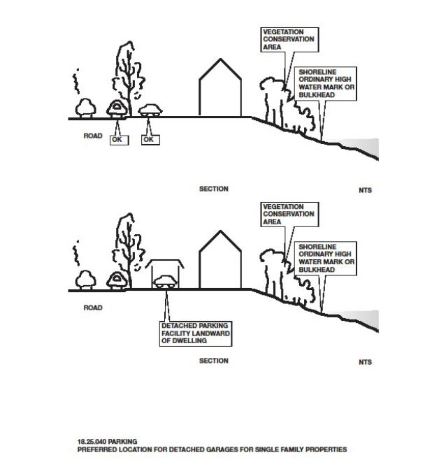
(Ord. 652 § 1 (Exh. A), 2015).
18.25.050 Public access.
A. Intent and Applicability. Shoreline public access is the physical ability of the general public to reach and touch the water’s edge or the ability to have a view of the water and the shoreline from upland locations. There are a variety of types of public access, including docks and piers, boat launches, pathways and trails, promenades, street ends, picnic areas, beach walks, viewpoints and others. An important goal of the Shoreline Management Act is to protect and enhance public access to the State’s shorelines. The public’s ability to enjoy the physical and aesthetic qualities of natural shorelines of the State is to be preserved to the greatest extent feasible consistent with the overall best interest of the State and its citizens. Alterations of the natural conditions of the shorelines of the State, in those limited instances when authorized, shall be given priority for development that will provide an opportunity for substantial numbers of people to enjoy these shorelines.
Public access and use of the shoreline is supported, in part, by the Public Trust Doctrine. The essence of the doctrine is that the waters of the State are a public resource owned by and available to all citizens equally for the purposes of navigation, conducting commerce, fishing, recreation and similar uses, and that this trust is not invalidated by private ownership of the underlying land. The doctrine limits public and private use of tidelands and other shorelands to protect the public’s right to use the waters of the State. The Public Trust Doctrine does not allow the public to trespass over privately owned uplands to access the tidelands. It does, however, protect public use of navigable waterbodies.
Standards for the dedication and improvement of public access, as noted in the SMP guidelines found in WAC 173-26-221(4)(d)(iii), apply in shoreline jurisdiction as provided in this section.
B. General Policies.
1. Developments, uses, and activities should be designed and operated to avoid or minimize blocking, reducing, or adversely interfering with the public’s visual or physical access to the water and the shorelines.
2. Public access should be a primary use in its own right or a secondary use that is created or enhanced as development or redevelopment occurs; provided, that private property rights and public safety are protected. Public access elements may include, but should not be limited to, the following:
a. Bicycle and other shared use pathways along or adjacent to the shoreline;
b. Shoreline parks;
c. Beach areas;
d. Piers, wharves, docks, and floats;
e. Transient moorage;
f. Trails, promenades, boardwalks, pedestrian overpasses or underpasses over or under the railroad ROW, or other pedestrian ways along or adjacent to the shoreline edge.
3. New development should avoid or minimize conflict with existing public access or planned public access projects and provide mitigation if impacts cannot be avoided.
4. Impacts to public access from new development should be mitigated through the provision of on-site visual and physical public access, unless such access is shown to be incompatible due to reasons of safety, security, or impact to the shoreline.
5. Development projects on public property or proposed by public entities should be required to incorporate public access features except where access is incompatible with safety, security, or environmental protection.
6. Public access provisions should be consistent with all relevant constitutional and other limitations that apply to regulations that are placed on private property, including the nexus and proportionality requirements.
7. Public access requirements on privately owned lands should be commensurate with the scale of the development and should be reasonable, effective and fair to all affected parties including but not limited to the landowner and the public.
8. Public access should not compromise, in any significant manner, the rights of navigation and space necessary for water-dependent uses to prevail.
9. Where maintenance of views from adjacent properties and water-dependent uses or physical public access conflict, water-dependent uses and physical public access should prevail.
10. The City should continue working with private property owners, the City of Lakewood and Pierce County to develop shoreline trail systems and other means of shoreline access in accordance with the Chambers Creek Properties Master Site Plan and the City’s Park, Recreation and Open Space Plan.
11. Shoreline access improvements within the Chambers Creek Properties should be developed in accordance with the Chambers Creek Properties Master Site Plan.
C. Access Preferences and Alternatives Policies.
1. Preference should be given generally to provision of on-site public access. Off-site public access is appropriate where it would provide more meaningful public access, prevent or minimize safety or security conflicts, or where off-site public access is consistent with an approved public access plan.
2. Public and private property owners should use a variety of techniques, including acquisition, leases, easements and design and development innovations, in order to achieve the public access goals and to provide diverse public access opportunities.
3. Where public access cannot be provided on-site, the City should consider innovative measures to allow permit applicants to provide public access off-site, including contributing to a public access fund to develop planned shoreline access projects.
4. Water-enjoyment and non-water-oriented uses that front on the shoreline should provide continuous public access along the water’s edge.
5. Developments within shoreline jurisdiction that do not have shoreline frontage should provide public access by providing trails or access corridors through or from their sites or by providing view improvements, including viewing platforms.
6. Where new development occurs in a location where access along or to the shoreline already exists, the new development should either contribute additional recreation or access facilities to enhance the existing access, or consider view improvements.
7. An applicant may construct public access improvements before site development as a part of an overall site master plan, which may be phased. The applicant would receive credit for those improvements at time of development.
D. Design Policies.
1. Public access should be designed and located in such a way that does not result in a net loss of ecological functions.
2. Public access associated with marinas, boat ramp/launch facilities, private and public docks for public moorage, and similar water-dependent uses should be provided as close as possible to the water’s edge without significantly adversely affecting a sensitive environment or resulting in significant safety hazards. Improvements should allow physical contact with the water where feasible.
3. Public spaces should be designed to be recognizable as “public” areas and to promote a unified access system, including the design and location of site details and amenities, and to provide a safe and welcoming experience for the public.
4. Public spaces should be designed for the greatest number and diversity of people and for a variety of interests.
5. Public spaces should be designed and located to connect to other public areas, street ends and other pedestrian or public thoroughfares.
6. New public access should be sited and appropriately designed to avoid causing detrimental impacts to the operations of existing water-dependent and water-related uses.
E. General Regulations.
1. Where feasible, new development, uses and activities shall be designed and operated to avoid and minimize blocking, reducing, or adversely interfering with the public’s physical access to the water and shorelines.
2. Public access provided by street ends, public utilities, and public rights-of-way shall not be diminished without full mitigation for those impacts.
3. Existing public access shall not be eliminated unless the applicant shows that there is no feasible alternative and replaces the public access with access of comparable functions and value at another location, consistent with subsection (G)(2) of this section.
4. Publicly financed or subsidized shoreline erosion control measures shall not restrict appropriate public access to the shoreline except where such access is determined to be infeasible because of incompatible uses, safety, or security.
5. Public access easements and shoreline permit conditions shall be recorded on the deed of title and/or on the face of a plat or short plat as a condition of approval. Said recording with the County Auditor’s Office shall occur at the time of shoreline permit approval. Future actions by the applicant and/or successors in interest or other parties shall not diminish the usefulness or value of the public access provided, unless a new shoreline permit is secured.
6. Required public access improvements shall be fully developed and available for public use at the time of occupancy of the use or activity unless there are mitigating circumstances and an agreement setting forth an alternative schedule acceptable to the Examiner is in place.
F. Regulations – Design of Public Access.
1. Public access trails and shared use pathways shall be located, designed and maintained in accordance with all of the following:
a. Where open space is provided along the shoreline and public access can be provided in a manner that will not adversely impact shoreline ecological functions and/or processes, a trail or other shared use pathway generally parallel to the ordinary high water mark of the property may be authorized subject to the following:
(1) The trail or shared use pathway shall be buffered from sensitive ecological features and provide limited and controlled access to sensitive features and the water’s edge where appropriate; and
(2) Fencing may be provided to control damage to plants and other sensitive ecological features, where appropriate.
(3) Landscaping associated with trail or pathway development shall be native and drought tolerant or site appropriate.
(4) Enhancement of shoreline functions, including native plantings, shall be incorporated into trail designs as mitigation for development impacts where necessary and where a clear benefit can be demonstrated.
b. Trails or shared use pathways located within a Natural shoreline environment shall be no greater than six feet in total improved width, which may include up to four feet of surface and one-foot shoulders. Not including landscaping, no more than four feet of improved surface is preferable in most cases.
c. Trails or shared use pathways located in other shoreline environments shall be the minimum width necessary to safely accommodate the proposed use and to avoid and minimize impacts to ecologically sensitive resources. In no case shall they be more than 18 feet in total improved width, which may include up to 14 feet of surfaced trail and two-foot shoulders.
d. Trails or shared use pathways shall be located outside of the vegetation conservation area except when providing access from an upland area to the shoreline, within a public park, or in conjunction with marinas, boat ramp/launch facilities, private and public docks for public moorage, and similar water-dependent uses.
e. Trails or shared use pathways may be located within the shoreline setback and vegetation conservation area when providing an integral link for the Chambers-Leach Creek regional trail system where topography or other physical constraints make it impractical to locate the trail or pathway segment outside of these areas. Such trails or pathways shall be placed at least 25 feet from the ordinary high water mark, except for bridges, limited spurs to physical access points and overlooks comprising no more than 10 percent of the overall lineal length of the proposed trail (see Figure 5 below).
FIGURE 5 – PUBLIC ACCESS TRAIL LOCATIONS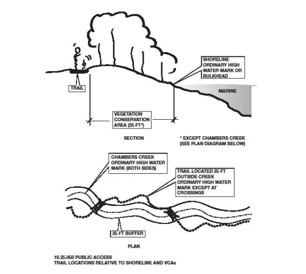
f. Gravel, woodchips, or pervious pavement shall be used for trails or shared use pathways within a vegetation conservation area unless the Administrator determines that such material is not in the public interest because of safety, durability, aesthetic or functionality concerns.
g. Trails or shared use pathways shall be subject to compliance with specific design standards or guidelines as described in the Chambers Creek Properties Master Site Plan, the City of University Place Park, Recreation and Open Space Plan, or other trail or recreation plans, when applicable.
2. Public access shall be located adjacent to other public areas, accesses and connecting trails, with connections to the nearest public street; provisions for handicapped and physically impaired persons shall be provided unless infeasible due to site conditions such as steep slopes.
3. Where views of the water or shoreline are available and physical access to the water’s edge is not present or appropriate, a public viewing area shall be provided.
4. Design shall minimize intrusions on privacy by avoiding locations adjacent to windows and/or outdoor private open spaces or by screening or other separation techniques.
5. Design shall provide for the safety of users, including the control of offensive conduct through public visibility of the public access area, or through provisions for oversight. The Administrator may authorize a public access to be temporarily closed in order to develop a program to address offensive conduct. If offensive conduct cannot be reasonably controlled, alternative facilities may be approved through a permit revision.
6. Public amenities appropriate to the use of a public access area such as a covered shelter, benches, or picnic table shall be provided.
7. Commercial or mixed use developments that attract a substantial number of persons, and developments by government/public entities, may be required to provide public restrooms, facilities for disposal of animal waste and other appropriate public facilities.
8. Public access facilities may be developed over water subject to the mitigation sequencing priorities in UPMC 18.25.070(C)(4) and all other applicable provisions of this Shoreline Program. All ecological impacts shall be mitigated to achieve no net loss of shoreline ecological functions and system-wide processes.
G. Public Access – When Required.
1. Public access shall be required to the extent allowed by law in the review of all shoreline substantial development permits and shoreline conditional use permits in the following circumstances:
a. The project is publicly funded or on public lands;
b. The project consists of new or reconstructed publicly funded dikes or levees, jetties, and groins (other than those associated with detached single-family dwellings);
c. Where any of the following conditions exist:
(1) The project increases or creates demand for public access;
(2) The project impacts or interferes with existing access by blocking access or discouraging use of existing access;
(3) The project impacts or interferes with public use of waters subject to the Public Trust Doctrine;
(4) The project includes a non-water-dependent use, or a nonpreferred use under the SMA; or
(5) The project involves the creation of more than four residential lots or dwelling units within shoreline jurisdiction.
2. If public access is required pursuant to subsection (G)(1)(c) of this section, the City shall impose permit conditions requiring public access that is roughly proportional to the impacts caused by the proposed use or development.
3. When public access is required pursuant to subsection (G)(1)(c) of this section, the Examiner shall make specific findings that the use or development satisfies one or more of the conditions in subsection (G)(1)(c) of this section and that the permit conditions requiring public access are roughly proportional to the impacts caused by the proposed use or development.
4. Public access shall not be required for the following uses or activities:
a. Single-family residential developments consisting of four or fewer residential lots or dwelling units;
b. Agricultural activities;
c. Dredging;
d. Landfill and excavation;
e. Private docks serving four or fewer dwelling units;
f. Instream structures, unless publicly funded;
g. Shoreline stabilization, unless publicly funded;
h. Utility projects; or
i. Ecological restoration or enhancement activities not associated with development.
H. Access Preferences and Alternatives.
1. On-site, physical access is preferred.
2. The Examiner may approve alternatives to on-site, physical access to the shoreline if the applicant can demonstrate with substantial and credible evidence that one or more of the following conditions exist:
a. Unavoidable health or safety hazards to the public exist which cannot be prevented by any practical means;
b. The configuration of existing parcels and structures block potential access areas in such a way that cannot be reasonably remedied by the proposed development;
c. Public access will jeopardize inherent security requirements of the proposed development or use and the impacts on security cannot be satisfied through the application of alternative design features or other solutions;
d. The cost of providing on-site access, easement, or an alternative amenity is unreasonably disproportionate to the total long-term cost of the proposed development;
e. Environmental impacts that cannot be mitigated, such as damage to spawning areas or nesting areas, will result from the public access; or
f. Public access is infeasible due to incompatible adjacent uses where the incompatibility cannot be mitigated.
3. Prior to approving alternatives to on-site physical access due to one or more of the conditions listed in subsection (H)(2) of this section, the Examiner should first consider on-site access alternatives such as limiting hours to daylight use, using alternative site configurations, or incorporating design elements such as fences, terraces, hedges, and/or other landscaping to separate uses and activities.
4. When public access is required pursuant to subsection (G)(1) of this section, the Examiner may approve public access under subsection (H)(2) of this section that includes the preservation of shoreline views consistent with UPMC 18.25.110, the establishment of public access easements to and along the shoreline, and/or enhancement of an adjacent street end, park, or other public access feature commensurate with the degree of impact caused by the development. These alternative forms of public access shall not be required by the Examiner when public access is not required pursuant to subsection (G)(1) of this section.
5. A project applicant may participate in “advance mitigation” by providing public access improvements prior to the time a project is constructed.
(Ord. 652 § 1 (Exh. A), 2015).
18.25.060 Scientific and educational activities.
A. Intent and Applicability. It is the intent of the City to preserve and prevent the destruction of or damage to any site having scientific or educational value, excluding schools, museums or similar facilities, and to support scientific and educational efforts when appropriate ecological safeguards are utilized. Examples may include, but are not limited to, water quality testing, stream flow monitoring, and the installation of interpretive signage.
B. Policies.
1. Encourage scientific and educational activities related to shoreline ecological functions and processes.
C. Regulations.
1. Scientific and educational uses and activities are limited to those that will not:
a. Jeopardize existing wildlife populations or organisms;
b. Permanently alter the character of biological habitats; and
c. Degrade the character of the shoreline environment in which they are located.
2. Temporary disruption of biological systems may be authorized when a scientific activity will result in their restoration or improvement, and only when a restoration plan is approved by the City and other agencies with jurisdiction.
3. Permits encompassing a variety of scientific or educational activities over an extended period of time may be granted; provided, that limits on the duration of approval are established. Temporary facilities necessary for the conduct of a scientific project shall be removed at the conclusion of the prescribed research activity period.
4. Temporary facilities used in conjunction with the scientific or educational project shall be removed at the conclusion of the project.
(Ord. 652 § 1 (Exh. A), 2015).
18.25.070 Shoreline ecological protection and mitigation.
A. Intent and Applicability.
1. The Shoreline Management Act and the Shoreline Master Program Guidelines place a primary emphasis on the protection of shoreline ecological functions and system-wide processes. In accordance with Chapter 173-26 WAC, this Shoreline Program must ensure that shoreline uses, activities, and modifications will result in no net loss to these processes and functions.
2. The protection, restoration and enhancement of shoreline ecological functions and system-wide processes are high priorities of this Shoreline Program. The policies and regulations established herein are to be applied to all uses, developments and activities that may occur within the shoreline jurisdiction.
B. Policies.
1. All shoreline use and development should be carried out in a manner that avoids or minimizes adverse impacts so that the resulting ecological condition does not become worse than the current condition. This means assuring no net loss of ecological functions and processes and protecting critical areas that are located within the shoreline jurisdiction.
2. Natural features of the shoreline and nearshore environments that provide ecological functions and should be protected include marine and freshwater riparian habitat, banks and bluffs, beaches and backshore, critical saltwater and freshwater habitat, and wetlands and streams. Shoreline processes that should be protected include erosion and accretion, sediment delivery, transport and storage, organic matter input, and large woody debris recruitment.
3. Important habitat that provides the shoreline’s unique value, including estuaries and critical saltwater habitats that include intertidal wetlands, kelp beds, eelgrass beds and spawning areas for forage fish such as sand lance, sand spits, mud flats, and areas with which priority species have a primary association, should be preserved and protected.
4. Protection and restoration of critical saltwater habitats should integrate management of shorelands as well as submerged areas.
5. Direct and indirect cumulative impacts of proposed actions should be considered for all use and development of the shoreline.
6. Development standards for density, setbacks, impervious surface, shoreline stabilization, vegetation conservation, critical areas, and water quality should protect existing shoreline functions and processes. During review, the Administrator should consider the expected impacts associated with proposed shoreline development when assessing compliance with this policy.
7. Where a proposed use or development creates environmental impacts not otherwise avoided or mitigated by compliance with this Shoreline Program, mitigation measures should be required to ensure no net loss of shoreline ecological functions and system-wide processes.
8. The City should work with other local, State, and Federal regulatory agencies, tribes, and nongovernment organizations to ensure that mitigation actions carried out in support of this Shoreline Program are designed to be successful and achieve beneficial ecological outcomes. This includes such measures as mitigation banks, fee-in-lieu programs, and assisting applicants/proponents in planning, designing, and implementing mitigation.
9. The City should develop a program to periodically review conditions on the shoreline and conduct appropriate analysis to determine whether or not other actions are necessary to protect and restore shoreline ecology to ensure no net loss of ecological functions.
C. Regulations – No Net Loss and Mitigation.
1. All shoreline uses and development, including preferred uses and uses that are exempt from shoreline permit requirements, shall be located, designed, constructed, and maintained in a manner that results in no net loss of shoreline ecological functions and processes.
2. To comply with the policies in subsection (B) of this section, applicants/proponents of new shoreline use and development shall demonstrate that all reasonable efforts have been taken to avoid adverse impacts. Mitigation shall occur in the following order of priority. In determining appropriate mitigation measures, lower priority measures shall be applied only when higher priority measures are determined to be infeasible or inapplicable.
a. Avoiding the adverse impact altogether by not taking a certain action or parts of an action, or moving the action;
b. Minimizing adverse impacts by limiting the degree or magnitude of the action and its implementation by using appropriate technology and engineering, or taking affirmative steps to avoid or reduce adverse impacts;
c. Rectifying the adverse impact by repairing, rehabilitating or restoring the affected environment;
d. Reducing or eliminating the adverse impact over time by preservation and maintenance operations during the life of the action;
e. Compensating for the adverse impacts by replacing, enhancing, or providing similar substitute resources or environments; and
f. Monitoring the impact of the compensatory projects and taking appropriate corrective measures.
3. Mitigation actions shall not have a significant adverse impact on other shoreline ecological functions.
4. When compensatory mitigation measures are required, all of the following shall apply:
a. The quality and quantity of the replaced, enhanced, or substituted resources shall be the same or better than the affected resources;
b. The mitigation site and associated vegetative planting shall be nurtured and maintained such that healthy native plant communities can grow and mature over time;
c. The mitigation shall be informed by pertinent scientific and technical studies, including but not limited to the Shoreline Inventory and Characterization Report, the Shoreline Restoration Plan and other background studies prepared in support of this Shoreline Program;
d. The mitigation plan shall include contingencies should the mitigation fail during the monitoring/maintenance period;
e. The mitigation shall replace the functions as quickly as possible following the impacts to ensure no net loss;
f. The mitigation activity shall be monitored and maintained to ensure that it achieves its intended functions and values; and
g. The applicant shall post a financial surety equal to the estimated cost of the mitigation in order to ensure the mitigation is carried out successfully. The surety shall be refunded to the applicant upon completion of the mitigation activity and any required monitoring.
5. Mitigation measures shall occur in the immediate vicinity of the impact or at an alternative location within the same watershed or appropriate section of marine shoreline that provides greater and more sustainable ecological benefits. When evaluating these benefits, the City shall consider limiting factors, critical habitat needs, and other factors identified in the Restoration Plan (Appendix A), or an approved watershed or comprehensive resource management plan. The City may also approve use of alternative mitigation practices such as in-lieu fee programs, mitigation banks, and other similar approaches, provided they have been approved and sanctioned by the Department of Ecology, the Department of Fish and Wildlife or the Army Corps of Engineers. When uses or activities are proposed along shorelines that also contain critical areas, vegetation management plans may be consolidated with habitat management plans required under UPMC 17.25.025.
D. Regulations – Critical Areas.
1. The City’s critical areas regulations, codified under UPMC Title 17, apply to critical areas in the shoreline jurisdiction. Chapters 17.05, 17.10, 17.15, 17.20, 17.25, 17.30 and 17.35 UPMC are herein incorporated into this SMP, except as noted in subsection (D)(5) of this section. The critical areas regulations being incorporated into the SMP are those referenced in Ordinance No. 630, effective October 28, 2013, and Ordinance No. 670, effective June 27, 2016. In the event these regulations are amended, the edition referenced herein will still apply in shoreline jurisdiction. Changing this reference to recognize a new edition will require a master program amendment.
2. If there are any conflicts or unclear distinctions between this Shoreline Program and the critical areas regulations, the requirements that are the most specific shall apply.
3. All uses and development occurring within the shoreline jurisdiction shall comply with the City’s critical area regulations as adopted herein.
4. Nonconforming structures and uses within critical areas that are within shoreline areas shall be subject to the provisions of this Shoreline Program.
5. Critical areas provisions that are not consistent with the SMA, Chapter 90.85 RCW, and supporting Washington Administrative Code chapters shall not apply in shoreline jurisdiction, as follows:
a. Critical area provisions do not extend shoreline jurisdiction beyond the limits specified in this Shoreline Program. For regulations addressing critical area buffer areas that are outside shoreline jurisdiction, see UPMC Title 17.
b. Provisions relating to variance procedures and criteria in Chapter 17.10 UPMC do not apply in shoreline jurisdiction. Variance procedures and criteria have been established in UPMC 18.15.050 and in WAC 173-27-170.
c. Reasonable uses exceptions in Chapter 17.10 UPMC are not available for relief from critical area standards within the shoreline jurisdiction. Instead, applicants seeking relief from the critical area standards shall apply for a shoreline variance.
d. Provisions relating to the substitution of Army Corps of Engineers Section 404 individual permits for City of University Place wetland reviews do not apply in shoreline jurisdiction, as the Section 404 individual permit review process may not fully address requirements of this Shoreline Program.
e. In shoreline jurisdiction, identification of wetlands and delineation of their boundaries shall be done in accordance with the approved Federal wetland delineation manual and applicable regional supplements, per WAC 173-22-035. Specifically, the delineation and wetland analysis requirements in UPMC 17.35.025(A) do not apply.
f. In shoreline jurisdiction, the wetland point scale used to separate wetland categories in UPMC 17.35.020(A) through (D) does not apply. Category I wetlands are those that score 23 or more points, Category II wetlands are those that score between 20 and 22 points, Category III wetlands are those that score between 16 and 19 points, and Category IV wetlands are those that score between nine and 15 points.
g. In shoreline jurisdiction, fish and wildlife habitat areas as defined in UPMC 17.10.005 shall not include such artificial features or constructs as irrigation delivery systems, irrigation infrastructure, irrigation canals, or drainage ditches that lie within the boundaries of and are maintained by a port district or an irrigation district or company.
E. Regulations – Critical Saltwater Habitats.
1. Docks, piers, bulkheads, bridges, fill, floats, jetties, utility crossings, and other human- made structures shall not intrude into or over critical saltwater habitats except when all of the conditions below are met:
a. The public’s need for such an action or structure is clearly demonstrated and the proposal is consistent with protection of the public trust, as embodied in RCW 90.58.020;
b. Avoidance of impacts to critical saltwater habitats by an alternative alignment or location is not feasible or would result in unreasonable and disproportionate cost to accomplish the same general purpose;
c. The project, including any required mitigation, will result in no net loss of ecological functions associated with critical saltwater habitat; and
d. The project is consistent with the State’s interest in resource protection and species recovery.
2. Private, noncommercial docks, including piers, ramps and floats, for individual residential or community use may be authorized; provided, that:
a. Avoidance of impacts to critical saltwater habitats by an alternative alignment or location is not feasible; and
b. The project, including any required mitigation, will result in no net loss of ecological functions associated with critical saltwater habitat.
3. Until an inventory of critical saltwater habitat has been done, the City shall require all over-water and near-shore developments in marine and estuarine waters to perform an inventory of the site and adjacent beach sections to assess the presence of critical saltwater habitats and functions. The methods and extent of the inventory shall be consistent with accepted research methodology. At a minimum, the City and applicant should consult with Department of Ecology technical assistance materials for guidance.
F. Regulations – Geologically Hazardous Areas.
1. New development or the creation of new lots that would cause foreseeable risk from geological conditions during the life of the development is prohibited.
2. New development that would require structural shoreline stabilization over the life of the development, except where stabilization is needed to protect allowed uses where no alternative locations are available and no net loss of ecological functions will result, is prohibited.
G. Regulations – Cumulative Impacts.
1. In the granting of all conditional use permits and variances, consideration shall be given to the cumulative impact of additional requests for like actions in the area. For example, if conditional use permits were granted for other developments in the area where similar circumstances exist, the total of the conditional uses shall also remain consistent with the policies of RCW 90.58.020 and shall not produce substantial adverse effects to the shoreline environment.
2. When determining whether a proposed use or development could cause a net loss of ecological functions, the cumulative impacts of individual uses and developments, including preferred uses and uses that are exempt from permit requirements, shall be considered.
3. The City may require the applicant/proponent to prepare special studies, assessments and analyses as necessary to identify and address cumulative impacts including, but not limited to, impacts on fish and wildlife habitat, public access/use, aesthetics, and other shoreline attributes.
4. Proponents of shoreline use and development shall take the following factors into account when assessing cumulative impacts:
a. Current ecological functions and human factors influencing shoreline natural processes;
b. Reasonably foreseeable future use and development of the shoreline;
c. Beneficial effects of any established regulatory programs under other local, State and Federal laws; and
d. Mitigation measures implemented in conjunction with the proposed project to avoid, reduce, and/or compensate for adverse impacts.
e. Any use or development that will result in or contribute to unmitigated cumulative impacts is prohibited.
(Ord. 670 § 1 (Exh. A), 2016; Ord. 652 § 1 (Exh. A), 2015).
18.25.080 Shoreline restoration and enhancement.
A. Intent and Applicability. Restoration refers to the reestablishment or upgrading of impaired ecological shoreline processes or functions. The following policies and regulations are intended to guide actions that are designed to achieve improvements in shoreline ecological functions over time in shoreline areas where such functions have been degraded. The overarching purpose is to achieve overall improvements over time when compared to the condition upon adoption of this Shoreline Program, as detailed in the Shoreline Inventory and Characterization Report.
Restoration is distinct from mitigation measures necessary to achieve no net loss of shoreline functions, and the City’s commitment to plan for restoration will not be implemented through regulatory means. This Shoreline Program recognizes the importance of restoration of shoreline ecological functions and processes and encourages cooperative restoration efforts and programs between local, State, and Federal public agencies, tribes, nonprofit organizations, and landowners to address shoreline with impaired ecological functions and/or processes.
B. Policies.
1. Restoration actions should restore shoreline ecological functions and processes as well as shoreline features and should be targeted towards meeting the needs of sensitive and/or locally important plant, fish and wildlife species as well as the biologic recovery goals for local species and populations.
2. Restoration and enhancement should be integrated with other natural resource management efforts such as the Puget Sound Salmon Recovery Plan and the University Place Comprehensive Plan.
3. Restoration actions outside of the shoreline jurisdiction that have a system-wide benefit should be considered.
4. When prioritizing restoration actions, the City should give highest priority to measures that have the greatest chance of re-establishing shoreline ecological functions and processes.
5. Restoration and enhancement measures should be incorporated into the design and construction of new uses and development, public infrastructure (e.g., roads and utilities), and public recreation facilities.
C. Regulations.
1. Restoration and enhancement shall be allowed on all shorelines, and carried out by the applicant/proponent in accordance with an approved vegetation management plan. This plan shall be designed, constructed and maintained in accordance with the requirements of UPMC 18.25.100(G).
2. Restoration/enhancement projects shall be designed to increase quality, width and diversity of native vegetation riparian habitats to provide safe migration pathways for fish and wildlife, food, nest sites, shade, perches, and organic debris, where appropriate. Projects should strive to control nonindigenous plants or weeds that adversely affect native vegetation or habitats.
3. In accordance with RCW 90.58.580, a Substantial Development Permit is not required for development on land that is brought under shoreline jurisdiction due to a shoreline restoration project. However, projects are still required to comply with the regulations of this Master Program.
4. Projects taking place on lands that are brought into shoreline jurisdiction due to a shoreline restoration project that caused a landward shift of the OHWM may apply to the Administrator for relief from the SMP development standards and use regulations under the provisions of RCW 90.58.580. Any relief granted shall be strictly in accordance with the limited provisions of RCW 90.58.580, including the specific approval of the Department of Ecology.
(Ord. 652 § 1 (Exh. A), 2015).
18.25.090 Signage.
A. Signage Policies.
1. Signs should not block or otherwise interfere with visual access to the water or shorelands.
2. Signs should be designed and placed so that they are compatible with the aesthetic quality of the existing shoreline and adjacent land and water uses.
B. Signage Regulations.
1. Signage shall be regulated in conformance with Chapter 19.75 UPMC, Signs, except that the following provisions shall apply within the shoreline jurisdiction:
a. All off-site signs, except for directional signs, shall be prohibited;
b. All signs shall be located and designed to avoid interference with vistas, viewpoints, and visual access to the shoreline;
c. Signs shall be designed and placed so that they are compatible with the aesthetic quality of the existing shoreline and adjacent land and water uses;
d. Over-water signs and signs on overwater structures or pilings, except as needed for navigational purposes, shall be prohibited; and
e. Lighted signs shall be designed to reduce glare when viewed from surrounding properties or water courses and avoid the direct shining of light into bodies of water.
(Ord. 652 § 1 (Exh. A), 2015).
18.25.100 Vegetation conservation.
A. Intent and Applicability. Vegetation conservation includes activities to protect and restore vegetation, specifically native trees and shrubs, along or near marine or freshwater shorelines to minimize habitat loss and the impact of invasive plants, erosion and flooding and contribute to the ecological functions of shoreline areas.
The provisions of this section establish vegetation conservation areas (VCAs), and set forth policies and regulations to limit the removal of native vegetation, encourage the restoration of native vegetation, control invasive weeds and nonnative species, and provide for appropriate tree pruning and maintenance. Vegetation conservation provisions apply to shoreline uses and developments, even if they are exempt from the requirement to obtain a permit.
B. Policies.
1. Developments and activities within the shoreline jurisdiction should be planned and designed to protect, conserve and restore native vegetation in order to protect and restore shoreline ecological functions and system-wide processes performed within riparian and nearshore areas, which include but are not limited to:
a. Providing shade necessary to maintain conditions suitable for nearshore aquatic biota and habitats;
b. Regulating microclimate in riparian and nearshore areas;
c. Providing organic inputs necessary for aquatic life, including providing food in the form of various insects and other benthic macro invertebrates;
d. Stabilizing banks, minimizing erosion and sedimentation, and reducing the occurrence/severity of landslides;
e. Reducing fine sediment input into the aquatic environment by minimizing erosion, aiding infiltration, and retaining runoff;
f. Improving water quality through filtration and vegetative uptake of nutrients and pollutants;
g. Providing a source of large woody debris to moderate flows, create hydraulic roughness, form pools, and increase aquatic diversity for salmonids and other species; and
h. Providing habitat for wildlife, including connectivity for travel and migration corridors.
2. Clearing and grading within VCA setbacks and VCAs should be restricted in order to maintain the functions and values of the shoreline environment, including protection of habitat, steep slopes and shoreline bluffs. Applicants should demonstrate that such alterations are the minimum necessary to accommodate a proposed use or development.
3. Adverse environmental and shoreline impacts of clearing and grading should be avoided wherever possible through proper site planning to avoid existing vegetation, construction timing and practices, bank stabilization, soil bioengineering and use of erosion and drainage control methods.
4. Shoreline uses and development should establish native shoreline vegetation so that the composition, structure and density of the vegetation resemble a natural, unaltered shoreline to the greatest extent possible.
5. Maintaining a well-vegetated shoreline with native species is preferred over clearing vegetation to create views or provide lawns. Limited and selective clearing for views and lawns, or for safety, may be allowed when slope stability and ecological functions are not compromised, but landowners should not assume that an unobstructed view of the water is guaranteed. Trimming and pruning are preferred over removal of native vegetation. Property owners are encouraged to avoid or minimize the use of fertilizers, herbicides and pesticides.
6. New lawns should not be established within the VCA due to their limited erosion control value, limited water retention capacity, and associated chemical and fertilizer applications.
7. Property owners are encouraged to preserve and enhance woody vegetation and native groundcovers to stabilize soils and provide habitat. Maintaining native plant communities is preferred over nonnative ornamental plantings because of their ecological value.
8. Educational materials should be provided and a public outreach program that educates landowners adjacent to shorelines about the importance of maintaining and enhancing vegetation along the shoreline should be established.
C. Regulations – General.
1. Parcels with frontage on marine waters, streams or wetlands shall preserve existing native vegetation, or where the development footprint is increased within a VCA, native vegetation shall be restored or enhanced within the following VCAs:
a. Within the Day Island Medium Intensity shoreline environment, the minimum width of the VCA shall be 25 feet measured landward of and perpendicular to the ordinary high water mark.
b. Within the Shoreline Residential shoreline environment, the minimum width of the VCA shall be 25 feet measured landward of and perpendicular to the ordinary high water mark. Properties within Sunset Beach and Day Island South Spit, and properties within other areas of Day Island that have an existing single-family dwelling located within 10 feet of the ordinary high water mark or which have at least 50 percent of the VCA occupied by an existing single-family dwelling and other primary structures, shall be exempt from the VCA restoration and enhancement requirements in UPMC 18.25.100(F)(1) due to the physical characteristics of the existing built environment, which make it impracticable to enhance or restore VCAs.
c. Within the Urban Conservancy shoreline environment, the minimum width of the VCA shall be 40 feet measured landward of and perpendicular to the ordinary high water mark.
d. Within the Natural shoreline environment, the minimum width of the VCA shall be 150 feet measured landward of and perpendicular to the ordinary high water mark.
2. Where structural shoreline stabilization such as a bulkhead is present, the VCA shall be measured from the landward edge of the stabilization structure to the width required by the designated shoreline environment.
3. A building setback of at least 10 feet from the landward edge of the VCA shall be required as per Table 18.30.B.
4. Development on parcels located within or adjacent to critical areas and critical area buffers must include vegetation in accordance with the provisions of UPMC Title 17, as incorporated into this SMP. Where conflicting standards are present, the more restrictive shall apply.
5. Except as provided herein, applicants for new development, expansion, or redevelopment within the VCA shall protect existing native vegetation within the VCA. If native vegetation within the VCA has been destroyed or significantly degraded, the applicant shall mitigate by restoring or enhancing the VCA in accordance with the provisions of this section and mitigation sequencing priorities in UPMC 18.25.070(C)(2).
6. Nonconforming and water-dependent uses that cannot provide a VCA due to the nature of the use or activity shall provide an equivalent area of vegetation elsewhere on the subject property. If it is not feasible to provide vegetation on site due to constraints such as lot size, lot configuration, topography, or existing site improvements, vegetation shall be provided off site in accordance with the provisions of UPMC 18.25.070(C)(5).
D. Regulations – Allowed Uses and Activities.
1. The following uses and activities may be authorized within the VCA if also allowed within the associated shoreline environment designation. Uses or activities listed in subsections (D)(1)(a) through (j) of this section shall be located in the outer half of the required VCA to the greatest extent feasible. If an allowed nonresidential use or activity requires more area than the allowed percentage outlined in subsection (D)(2) of this section, such as transportation facilities, utilities and public recreation trails, the applicant shall ensure that the proposed use or activity will not result in a net loss to shoreline ecological functions and plant vegetation in an equivalent area elsewhere on-site within the shoreline area. The Administrator shall utilize mitigation sequencing priorities in UPMC 18.25.070(C)(2) when considering intrusions into VCAs.
a. Transportation facilities and utilities only when it has been determined that alternative upland locations are not feasible;
b. Pedestrian access from upland areas to the shoreline, piers, docks, launch ramps, viewing platforms, wildlife viewing blinds and other similar water-oriented uses in accordance with UPMC 18.25.050(F)(1);
c. Public access viewpoints;
d. Public recreation trails and shared use pathways in accordance with UPMC 18.25.050(F)(1);
e. Educational facilities such as viewing platforms, wildlife viewing blinds and interpretive sites;
f. Water-dependent uses and equipment necessary for conducting water-dependent uses such as boat travel lifts for boat maintenance and upland storage;
g. Improvements that are part of an approved enhancement, restoration, or mitigation plan;
h. Shoreline stabilization only when it is part of an approved project.
i. Uncovered single-family residential decks, patios, access paths and play surfaces utilizing pervious materials and designs;
j. Benches, tables, hot tubs, fire pits, play equipment and other similar accessory structures or equipment provided in conjunction with a single-family residence; and
k. Removal of noxious weeds or hazardous trees.
2. Up to 25 percent of the VCA in a Shoreline Residential, Urban Conservancy, or Day Island Medium Intensity shoreline environment, and up to 10 percent of the VCA in a Natural shoreline environment, may be utilized for authorized uses and activities listed in subsections (D)(1)(a) through (j) of this section. Portions of the VCA occupied by primary structures, accessory structures, and other uses and activities that are not permitted under subsections (D)(1)(a) through (j) of this section, but which exist as of the effective date of this Shoreline Program, shall count toward these limits.
E. Regulations – Single-Family Residential Provisions.
1. Construction of new single-family residential structures and alterations to existing single- family residential properties, including primary structures, accessory structures and other improvements listed in subsections (D)(1)(i) and (j) of this section, shall protect existing native vegetation within the VCA.
FIGURE 6 – ALLOWABLE USES AND ACTIVITIES IN VEGETATION CONSERVATION AREA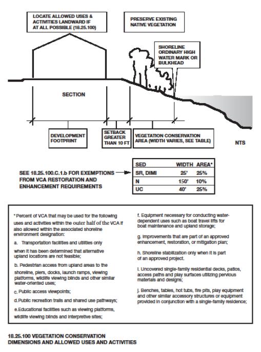
2. New single-family residences and other primary residential structures are not allowed within the VCA.
3. Within the Shoreline Residential shoreline environment, improvements listed in subsections (D)(1)(i) and (j) of this section, and pedestrian access authorized in UPMC 18.25.050(F), are allowed within the VCA subject to the following limitations:
a. Accessory structures and access paths shall cover no more than 25 percent of the VCA or 400 square feet, whichever is less;
b. Pervious materials and designs are used for walking or outdoor activity surfaces such as decks, patios, access paths and play surfaces;
c. Accessory structures, improvements and equipment allowed under this section shall maintain a minimum setback of 15 feet from the ordinary high water mark, except where an existing single-family residence is located within the VCA, this setback may be reduced by one foot for every foot the existing single-family residence encroaches into the VCA, to a minimum of five feet from the ordinary high water mark; and
d. The walking surface of decks or patios is no more than two feet above grade and is not covered.
4. Within the Day Island Medium Intensity, Urban Conservancy or Natural shoreline environments, new accessory structures and improvements not listed in subsections (D)(1)(i) and (j) of this section are not allowed within the VCA.
5. The development footprint shall not be increased within the VCA except in accordance with subsections (D) and (E) of this section. Expansions of existing primary structures and uses and activities not listed in subsections (D)(1)(a) through (j) of this section are not permitted within the VCA.
6. Where a nonconforming single-family residential property cannot provide the full width of the VCA plus an additional 10-foot building setback from the landward edge of the VCA, an equivalent area of vegetation shall be provided elsewhere on the site within shoreline jurisdiction at a location as close to the VCA as feasible. If it is not feasible to provide vegetation on site due to constraints such as lot size, topography, or existing site improvements, off-site enhancement should be considered, or the Administrator may waive some or all of the VCA requirements on a case-by-case basis. The applicant shall have the burden of proving that complying with the provisions of this section is not feasible. The Administrator shall consider the following criteria when determining feasibility and reviewing alternative enhancement, including, but not limited to:
a. An existing home and other primary structures located within and encompassing more than 50 percent of a VCA may be considered sufficient justification for demonstrating infeasibility;
b. Accessory structures and other improvements located within a VCA that are of a relatively temporary nature or that may be relatively easily removed such as landscaping and outdoor recreation improvements (decks, patios, sport courts and walkways) are not sufficient justification for demonstrating infeasibility;
c. The applicant can establish that a proposal for vegetation enhancement in areas outside of the VCA will result in no net loss of shoreline functions; and
d. Shoreline enhancement would be provided in lieu of vegetation enhancement, such as replacing hard armoring with soft armoring, removal of existing groins, etc.
F. Development Standards.
1. If the development footprint within the VCA would be increased by an allowed alteration, and if the VCA does not contain native vegetation or the native vegetation within the VCA has been significantly degraded, vegetation shall be required as follows:
|
VCA Enhancement and Restoration Requirements |
|
|---|---|
|
Percentage Increase in Development Footprint within VCA |
Percent of VCA Required to Be Enhanced or Restored |
|
20 percent or less |
20 percent |
|
20.1 – 30 percent |
40 percent |
|
30.1 – 40 percent |
60 percent |
|
40.1 – 50 percent |
80 percent |
|
50.1 percent or more |
100 percent |
Where sufficient area for enhancement or restoration is not available within the required VCA, other portions of the site or off-site enhancement opportunities should be considered, as described in subsection (E)(6) of this section.
2. Unauthorized clearing, grading, or vegetation removal is prohibited. Clearing, grading and vegetation removal within shoreline setbacks and VCAs shall be the minimum necessary for the intended use or development.
3. The width of a VCA may be averaged to account for variation in site conditions and to create a more natural arrangement of plantings (see Figure 7 below). The total square footage of landscaped area shall be calculated based on the minimum width area specified for each shoreline environment in subsection (C)(1) of this section. Area lost through reduction of the VCA width must be added to another portion of the VCA, which will result in no loss of VCA area. The minimum reduced width of the averaged area shall be no less than 50 percent of the minimum width specified in subsection (C)(1) of this section. The averaged VCA shall be configured to include all existing trees over six inches’ diameter breast height to the extent feasible.
4. When restoring or enhancing shoreline vegetation, applicants shall use native species that are of a similar diversity, density and type commonly found in riparian areas of western Washington. The vegetation shall be nurtured and maintained to ensure establishment of a healthy and sustainable native plant community over time. The preferred location of replacement vegetation is generally abutting, and parallel to, the OHWM or bulkhead rather than along a side property line or other location that is generally running perpendicular to the OHWM or bulkhead.
5. Trimming of trees and vegetation is allowed within the VCA subject to the following:
a. The limbing or crown thinning of trees larger than three inches’ dbh shall comply with International Society of Arboriculture Best Management Practices: Tree Pruning and ANSI A300 Standards. No more than 25 percent of the limbs on any single tree may be removed and no more than 25 percent of the canopy cover in any single stand of trees may be removed for a single view corridor. Trees determined to be damaged, diseased or safety hazards in accordance with UPMC 19.65.270, Tree retention, are exempt from these standards.
b. The trimming shall not directly impact the nearshore functions and values including fish and wildlife habitat;
FIGURE 7 – VEGETATION CONSERVATION AREA AVERAGING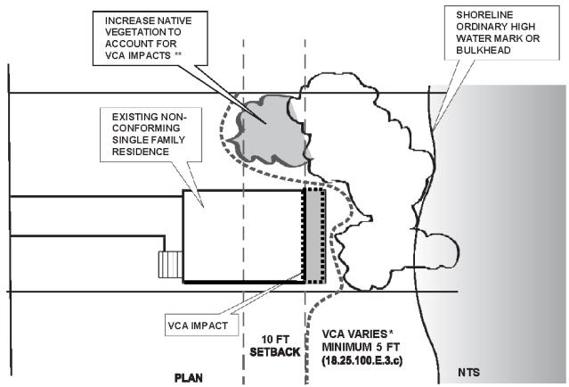
*THE WIDTH OF A VCA MAY BE AVERAGED TO ACCOUNT FOR VARIATION IN SITE CONDITIONS AND TO CREATE A MORE NATURAL ARRANGEMENT OF PLANTING.
** INCREASED NATIVE VEGETATION IS ONLY REQUIRED WHERE THERE IS AN INCREASE IN THE DEVELOPMENT FOOTPRINT WITHIN THE VCA (UPMC 18.25.100(F)).
UPMC 18.25.100(F)(3) VCA AVERAGING FOR DECK OR PATIO ENCROACHMENT
c. The trimming is not located within a critical area or associated buffer, unless such activity is exempt from the requirements of UPMC 17.15.030;
d. The trimming retains branches that hang over the water when feasible;
e. The trimming does not include tree topping, which is prohibited; and
f. The trimming does not include clearing of trees or vegetation.
6. Vegetation shall be maintained over the life of the use or development.
7. VCAs for uses other than single-family residences shall be placed in a separate tract in which development, other than public access facilities, is prohibited; protected by execution of an easement dedicated to a conservation organization or land trust; or similarly preserved through a permanent protective mechanism acceptable to the City.
8. Construction of new single-family residences or alterations to existing single-family residences that trigger restoration or enhancement of VCAs shall require a title notice to be recorded with the Pierce County Auditor, on forms provided by the City, describing development limitations and preservation requirements within the VCA.
9. Aquatic vegetation control shall only occur when native plant communities and associated habitats are threatened or where an existing water-dependent use is restricted by the presence of weeds. Aquatic vegetation control shall occur in compliance with all other applicable laws and standards, including Washington Department of Fish and Wildlife and Department of Ecology requirements.
G. Regulations – Vegetation Management Plan.
1. Clearing, grading and construction within the VCA shall only be authorized upon approval of a vegetation management plan, except when a proposal is deemed exempt from this plan requirement in accordance with subsection (G)(2) of this section. The vegetation management plan shall include or be subject to the following:
a. A map illustrating the distribution of existing plant communities in the area proposed for management. The map must be accompanied by a description of the vegetative condition of the site, including plant species, plant density, tree diameter at breast height; any natural or manmade disturbances, overhanging vegetation, and the functions served by the existing plant community (e.g., fish and wildlife values, slope stabilization);
b. A description of how mitigation sequencing in UPMC 18.25.070(C)(2) was used and how the plan achieves no net loss of shoreline ecological functions the vegetation is providing;
c. A description of the shade conditions created by existing vegetation. This description shall include an inventory of overhanging vegetation as well as a determination of how much shade is created by standing trees in order to assess the level of function that overhanging vegetation may be providing in terms of shade, cover, food resources and other functions;
d. A detailed landscape map indicating which areas will be preserved and which will be cleared, including tree removal;
e. Drawings illustrating the proposed landscape scheme, including the species, distribution, and density of plants. Any pathways or nonvegetated portions and uses shall be noted;
f. A description of any vegetation introduced for the purposes of fish and wildlife habitat;
g. Loss of wildlife habitat shall be mitigated on site. If on-site mitigation habitat is not possible, off-site mitigation shall be authorized in accordance with UPMC 18.25.070(C)(5); and
h. Installation of vegetation shall meet the following standards:
(1) Native species that are of a similar diversity, density and type commonly found in riparian areas of western Washington, and of a similar diversity and type to that occurring in the general vicinity of the site prior to any shoreline alteration, shall be used unless nonnative substitutes are authorized by the Administrator based on limited availability of native materials and the appropriateness of nonnative vegetation relative to soil and climate conditions;
(2) At the time of planting, plant materials shall be consistent with the standards in Chapter 19.65 UPMC, Landscaping/Trees, where applicable;
(3) The applicant may be required to install and implement an irrigation system to ensure survival of vegetation planted. For remote areas lacking access to a water system, an alternative watering method may be approved;
(4) Planting in the fall or early spring is preferred over summer for purposes of plant establishment; and
(5) For a period of five years after initial planting, the applicant shall replace any unhealthy or dead vegetation as part of an approved vegetation management plan. A landscaping maintenance guaranty equal to the cost of the landscaping less any irrigation system may be required prior to final project approval or release of any landscape performance bond that may also be required for the project. At the end of the five-year period, the applicant shall request that the City inspect the landscaping to ensure all planted material is alive and healthy. Any plant material needing replacement shall be replaced during the spring or fall growing season following plant loss, but not greater than 180 days from time of loss, and inspected prior to the release of the maintenance guaranty.
2. The Administrator may waive the requirement for a vegetation management plan for clearing, grading, construction, the installation of improvements listed in subsections (D)(1)(i) and (j) of this section, and the installation of pedestrian access authorized in UPMC 18.25.050(F), within the shoreline jurisdiction of a single-family residential property when all of the following standards are met:
a. The amount of shoreline jurisdiction that would be affected by the alteration does not exceed 100 square feet;
b. The cumulative total of shoreline jurisdiction that would be affected by the proposed alteration plus the shoreline area for which a vegetation management plan has previously been waived by the Administrator does not exceed 100 square feet;
c. The alteration would not result in the removal of any existing woody vegetation within the VCA;
d. The alteration would result in no net loss of shoreline function;
e. Where the development footprint would be increased by the proposed alteration, vegetation within the VCA will be enhanced or restored in accordance with subsection (F)(1) of this section.
3. The Administrator may waive some, but not all, of the vegetation enhancement or restoration requirements when the applicant proposes to improve shoreline ecological functions of the shoreline, through the removal of invasive species, shoreline restoration/enhancement, or removal of hard armoring. The applicant must demonstrate:
a. The proposed alternative(s) to vegetation enhancement or restoration would achieve the same or greater benefit to shoreline ecology as vegetation enhancement or restoration than would otherwise be required; and
b. The alteration, when considered in conjunction with the proposed alternatives to vegetation enhancement or restoration, would result in no net loss of shoreline function.
(Ord. 652 § 1 (Exh. A), 2015).
18.25.110 View protection.
A. Intent. Over four miles (65 percent) of University Place’s marine shoreline is under public ownership (Pierce County) or owned by the Burlington Northern Santa Fe Railroad. The County’s Chambers Creek Properties provide opportunities for the public to enjoy views of Puget Sound and the Olympic Mountains beyond. The Railroad effectively maintains an unobstructed linear corridor that preserves views from upland areas east of the tracks to the shoreline west of the tracks, due to the nearly complete absence of structures and substantial vegetation within the right-of-way. With the 2010 completion of the North Dock pedestrian overpass, which connects upland areas of the Chambers Creek Properties to several miles of beach on the waterward side of the railroad right-of-way, visual access to the shoreline has been greatly expanded. In addition, most of the freshwater shorelands within the Chambers Creek Canyon are publicly owned, either by Pierce County or the City of University Place. Future expansion of regional trail facilities within the canyon will expand opportunities for the public to enjoy the scenic qualities of the area.
The preservation and/or protection of scenic vistas, public views of the water and adjoining shoreline, and other aesthetic qualities of shorelines for public enjoyment is an important objective of this Shoreline Program. Protection of vistas and views can be achieved through multiple strategies including public ownership and use of shorelands, the inclusion of public access and viewpoints in private development, establishing key view corridors, establishing height limits and design standards, encouraging shoreline uses to orient towards the City’s shoreline resources, and requiring visual assessments where views may be impacted.
B. View and Aesthetic Policies.
1. Views and vistas to and from the water, by public and private entities, should be preserved to ensure that the public may continue to enjoy the physical and aesthetic qualities of the shoreline, including views of the water and views of shoreline areas from the water. Shoreline use and development activities should be designed and operated to minimize obstructions to the public’s visual access to the water and shoreline. Views and the physical form of the waterfront should be preserved by maintaining low structures near the water and at the tops of the bluffs, and by allowing non-view-blocking vertical development at the base of the bluffs.
2. New development should emphasize the water as a unique community asset.
3. To the extent feasible and consistent with the overall best interest of the State and the people generally, the public’s opportunity to enjoy the aesthetic qualities of shorelines of the State, including views of the water, should be advanced.
4. Shoreline use and development should not significantly detract from shoreline scenic and aesthetic qualities that are derived from natural or cultural features, such as shoreforms, vegetative cover and historic sites/structures.
5. New uses and developments in shoreline areas should be designed and constructed for a “human scale” and pedestrian orientation. View and public access corridors should be designed and developed to encourage pedestrian uses. The development of viewing areas should be encouraged wherever appropriate and feasible. Paths, benches, and picnic areas should be located to take full advantage of marine views. The use of rooftop surfaces for open space and public recreation purposes should be considered.
6. Shoreline use and development activities should be oriented to take the greatest advantage of shoreline views. Buildings should be designed to provide maximum view opportunities from within. Shoreline use and development that are adjacent to pedestrian accessways should orient building facades to those pedestrian routes and utilize facade treatments that maximize the enjoyment of shoreline areas.
7. Building design details such as form, scale, proportion, color, materials and texture should be encouraged to be compatible within shoreline areas wherever feasible. Buildings should incorporate architectural features that reduce scale such as increased setbacks, building modulation (vertical and horizontal), pitched roofs, angled facades, and reduced massing.
8. Uniform and recognizable design and signage elements should be provided for in public access and recreational areas.
D. View and Aesthetic Regulations.
1. No permit shall be issued pursuant to this Shoreline Program for any new or expanded building or structure of more than 35 feet above average grade level that will obstruct the view of a substantial number of residences in areas adjoining such shorelines except where this Shoreline Program does not prohibit the same and then only when overriding considerations of the public interest will be served.
2. Private uninterrupted views of the shoreline, although considered during the review process, are not expressly protected. Property owners concerned with the protection of uninterrupted views from private property are encouraged to obtain view easements, purchase intervening property and/or seek other similar private means of minimizing view obstruction.
3. Public shoreline views shall be protected by the use of measures, including, but not limited to, maintaining open space between buildings, clustering buildings to allow for broader view corridors, and minimizing building height, building lot coverage and floor area ratios.
4. When there is an irreconcilable conflict between water-dependent uses and physical public access and maintenance of views from adjacent properties, the water-dependent uses and physical public access shall have priority, unless there is a compelling reason to the contrary.
5. Buildings for which a shoreline substantial development permit, conditional use permit, or variance is required shall incorporate architectural features that reduce scale such as increased setbacks, building modulation (vertical and horizontal), pitched roofs, angled facades, and reduced massing.
6. All signs shall be located in such a manner that they minimize interference with public views. Freestanding signs which may disrupt views to the water, excluding traffic control signs, directional, and incidental signs, shall be placed on the landward side of development.
7. Where lighted signs and illuminated areas are authorized, such illuminating devices shall be shaded and directed so as to minimize, to the extent feasible, the negative impact of light and glare on neighboring properties, streets, public areas or water bodies. Signage shall comply with the illumination standards specified in UPMC 19.75.070(A)(6).
8. New development, uses and activities shall locate and screen trash and recycling receptacles, utility boxes, HVAC systems, electrical transformers and other appurtenances to minimize interference with public views. Building mechanical equipment shall be incorporated into building architectural features, such as pitched roofs, to the maximum extent feasible. Where mechanical equipment cannot be incorporated into architectural features, a visual screen shall be provided consistent with building exterior materials that obstructs views of such equipment but not the shoreline.
9. Utilities and accessory structures shall be designed and installed in such a way as to avoid impacts to scenic views and aesthetic qualities of the shoreline area.
10. Communication and radio towers shall not obstruct or destroy scenic views of the water. This may be accomplished by design, orientation and location of the tower, height, camouflage of the tower, or other features consistent with utility technology and the standards contained in Chapter 23.45 UPMC.
11. Fences, walls, hedges and other similar accessory structures shall be limited to four feet in height within the required building setback area from the shoreline, measured landward from the ordinary high water mark, except as otherwise permitted under this Shoreline Program, so as to not preclude or significantly interfere with the public’s view of the water.
12. Protection and/or enhancement of critical areas and their associated buffers shall be preferred over provisions for visual access, when there is an irreconcilable conflict between the two.
13. View protection does not justify the excessive removal of vegetation to create views or enhance partial existing views. Retaining vegetation and “windowing” or other pruning techniques shall be preferred options over vegetation removal. Tree thinning to enhance views shall be in accordance with UPMC 18.25.100(F)(5).
14. New development shall be located and designed to mitigate adverse impacts to views from public vistas, viewpoints, parks and scenic drives.
15. View corridors, as specified in Table 18.30.B, shall be provided concurrent with any new use or development. Modifications to existing use or development shall preserve existing view corridors whether or not they fully comply with the standard listed in Table 18.30.B.
16. Structures are not permitted in any required view corridor, except that weather protection features, public art, and areas provided primarily for public access, such as pedestrian bridges, may be located in or over these areas.
17. Buildings for which a shoreline substantial development permit, conditional use permit, or variance is required, when located on or adjacent to the water, shall employ materials that minimize reflected light.
E. Regulations – Visual Impact Assessment.
1. The applicant of a building or structure in excess of 35 feet above average grade level shall prepare and submit a visual analysis in conjunction with any development permit. Rooftop mechanical equipment and other structures that exceed the height limit of the underlying zoning classification pursuant to UPMC 19.45.050(C) are exempt from the visual analysis requirement provided the width of the equipment or structure does not exceed 20 percent of the length of the roof section of the building on which it is located. At a minimum, the analysis shall include an assessment of the following factors:
a. The nature, significance, and extent of existing public shoreline views across the property to include:
(1) The number of points from which such views exist, and the size and location of each;
(2) The content and quality of the particular view available from each such point, to include any territorial components that may be an integral part of the view; and
(3) The extent to which any views might be obscured or lost by seasonal or other changes in existing or anticipated vegetation or by like development on other property in the immediate area.
b. The nature, significance, and extent of public shoreline view loss or gain that would likely result from the proposed development to include:
(1) The number of existing viewpoints that would be impacted and the extent of view loss reasonably anticipated for each;
(2) Whether or not any existing views will be enhanced or new viewpoints created by the project; and
(3) Whether or not it appears that there will be a net gain or net loss of public shoreline views.
c. The extent to which public shoreline views are already being preserved or enhanced by the owner’s election, for whatever reason, to propose less than the full measure of development rights available to the subject.
d. The extent to which development on other properties in the immediate area has already degraded or preserved public shoreline views.
e. The extent to which public shoreline views from residences will be enhanced, preserved or degraded.
2. In evaluating the significance of existing public shoreline views, the following shall apply:
a. Public shoreline views from streets, sidewalks, parks or other public property shall be presumed of greater value than public shoreline views from privately owned property.
b. Public shoreline views of greater expanse shall be presumed of more value than those of significantly lesser expanse.
c. Public shoreline views from traveled portions of streets, not including sidewalks, shall be presumed of lesser value than those from other public areas.
d. New developments subject to visual impact assessment that cause full loss of public views shall be required to provide publicly accessible viewpoint/platforms. Such structures shall be located, designed, constructed and maintained in accordance with UPMC 18.25.050.
3. If the proposed structure would block or significantly compromise the view of a substantial number of residences in adjoining areas, the Examiner may limit the height of the structure or require design revisions or relocation to prevent the loss of views.
(Ord. 652 § 1 (Exh. A), 2015).
18.25.120 Water quality.
A. Intent and Applicability. Water quality is affected in numerous ways by human occupation and development of shoreline areas. Typically, the increase in impermeable surfaces as a result of development increases stormwater runoff volumes, causing higher stormwater discharges at higher velocities that cause scouring and erosion of stream banks. The degradation of water quality adversely affects wildlife habitat and public health. Policies and standards for managing water quality within shoreline jurisdiction are provided in this section.
B. Policies.
1. All shoreline uses and activities should be located, designed, constructed, and maintained to avoid significant ecological impacts that alter water quality, quantity, or hydrology.
2. The City should require reasonable setbacks, buffers, and stormwater management and encourage appropriate low-impact development techniques and materials to achieve the objective of lessening negative impacts on water quality.
3. Reasonable measures for controlling erosion, stream flow rates, or flood waters through the use of stream control works should be located, designed, constructed, and maintained so that net off-site impacts related to water do not degrade the existing water quality and quantity.
4. As a general policy, the City should seek to improve water quality, quantity, and flow characteristics in order to protect and restore ecological functions and ecosystem-wide processes of shorelines within shoreline jurisdiction. The City should implement this policy through the regulation of development and activities, through the design of new public works, such as roads, drainage, and water treatment facilities, and through coordination with other local, State, and Federal water quality regulations and programs.
5. Measures to treat runoff in order to maintain or improve water quality should be conducted on site before shoreline development creates impacts to water.
6. Shoreline use and development should minimize the need for chemical fertilizers, pesticides or other similar chemical treatments to prevent contamination of surface and ground water and/or soils, and adverse effects on shoreline ecological functions and values.
7. New developments in the shoreline jurisdiction should connect to the sanitary sewer system in areas where sewer service is available in accordance with City and Pierce County sanitary sewer regulations.
C. Regulations.
1. New developments in the shoreline jurisdiction shall connect to the sanitary sewer system and are prohibited from installing an on-site sewage system unless Pierce County determines that a sanitary sewer connection is infeasible and the Tacoma-Pierce County Health Department determines that an on-site sewage system may be designed and installed in accordance with the department’s regulations.
2. The City shall work cooperatively with Pierce County and the Tacoma-Pierce County Health Department to identify and correct sanitary sewer system failures.
3. Stormwater management facilities for new uses and development shall be designed, constructed, and maintained in accordance with NPDES permit requirements and the most current edition of the King County Surface Water Design Manual.
4. All shoreline development, both during and after construction, shall minimize impacts related to surface runoff through control, treatment and release of surface water runoff such that there is no net loss of receiving water quality in the shoreline environment. Control measures include but are not limited to runoff-intercepting ditches, catch basins, settling wet ponds, sedimentation ponds, oil/water separators, filtration systems, grassy swales, planted buffers, and fugitive dust controls. Regional or significant public control structures shall be placed outside of shoreline jurisdiction where feasible, and when such location is not feasible, such structure shall be placed outside of the minimum required building setback, where feasible.
5. Wood treated with creosote or pentachlorophenol may not be used in any hydraulic project. Wood treated with other preservatives may be used, provided it meets industry post-treatment standards and is sufficiently cured to minimize leaching into the water or bed.
6. All structures that come in contact with water shall be constructed of materials, such as wood, rock, concrete, approved plastic composites or steel that will not adversely affect water quality or aquatic plants or animals. Materials used for decking or other structural components shall be approved by applicable State agencies for contact with water to avoid discharge of pollutants from wave splash, rain or runoff.
7. The application of pesticides, herbicides, fertilizers and other chemicals that could adversely affect water quality is prohibited except for those chemicals specifically approved by the Department of Ecology for aquatic applications, aquatic uses and development.
(Ord. 652 § 1 (Exh. A), 2015).