


Chapter 18.30
SHORELINE USE POLICIES AND REGULATIONS
Sections:
18.30.010 Shoreline use and development – Intent.
18.30.040 Use and development standards tables.
18.30.010 Shoreline use and development – Intent.
The purpose of this chapter is to set forth policies and regulations for specific common uses and types of development that occur within University Place’s shoreline jurisdiction. Where a use is not listed in Table 18.30.A, the provisions of UPMC 18.15.060, Unclassified uses, shall apply in addition to the general provisions in this chapter. All uses and activities shall be consistent with the provisions of the shoreline environment designation in which they are located.
(Ord. 652 § 1 (Exh. A), 2015).
18.30.020 General provisions.
A. Applicability. The provisions in this section apply to all uses and development types that may be allowed within the shoreline jurisdiction.
B. Policies.
1. The City should give preference to those uses that are consistent with the control of pollution and prevention of damage to the natural environment, or are unique to or dependent upon uses of the State’s shoreline areas.
2. The City should ensure that all proposed shoreline development will not diminish the public’s health, safety, and welfare, as well as the land or its vegetation and wildlife, and should endeavor to protect property rights while implementing the policies of the Shoreline Management Act.
3. The City should reduce use conflicts by prohibiting or applying special conditions to those uses which are not consistent with the control of pollution and prevention of damage to the natural environment or are not unique to or dependent upon use of the State’s shoreline. In implementing this provision, preference should be given first to water-dependent uses, then to water-related uses and water-enjoyment uses.
4. Proposed use of the shoreline should be consistent with the City’s Comprehensive Plan. Conversely, upland uses on adjacent lands outside of immediate SMA jurisdiction (in accordance with RCW 90.58.340) should be consistent with the purpose and intent of this Shoreline Program as they affect the shoreline.
(Ord. 652 § 1 (Exh. A), 2015).
18.30.030 Regulations.
A. Developments that include a mix of water-oriented and non-water-oriented uses shall be considered water-oriented uses if the Administrator finds that the proposed development gives preference to uses that avoid impacts to shoreline ecological functions and processes, are dependent on a shoreline location, and enhance the public’s ability to enjoy the shoreline. Consistent with WAC 173-26-241(3)(d), commercial uses authorized as water-oriented shall incorporate appropriate design language and operational elements to meet such definition.
B. All uses not explicitly allowed in this Shoreline Program shall require a conditional use permit. The Hearing Examiner may impose conditions to ensure that the proposed development meets the policies of this Shoreline Program.
C. All development and uses must conform to all of the provisions of this Shoreline Program.
D. All development and uses shall conform to the shoreline use table and the development standards table in UPMC 18.30.040 unless otherwise stated.
(Ord. 652 § 1 (Exh. A), 2015).
18.30.040 Use and development standards tables.
Tables 18.30.A and 18.30.B indicate the allowable uses and development standards for allowed uses or activities. These tables shall be used in conjunction with the written provisions for each use. Footnotes provide additional clarification or conditions applicable to the associated use or shoreline environment designation.
|
Shoreline Uses |
Shoreline Environment Designation |
||||
|---|---|---|---|---|---|
|
P – Permitted1 C – Conditional Use X – Prohibited |
Day Island Medium Intensity |
Shoreline Residential |
Urban Conservancy |
Natural |
Marine Deepwater |
|
Agriculture |
|||||
|
|
X |
X |
X |
X |
X |
|
Aquaculture |
|||||
|
Recovery of Native Populations2 |
P |
P |
P |
P |
P |
|
Commercial Aquaculture |
C |
C |
C |
X |
C |
|
Boating Facilities |
|||||
|
Marinas / Yacht Clubs |
P |
X |
P4 |
X |
C |
|
Launch Ramps, Private |
P6 |
P6 |
P4, 6 |
X |
X |
|
Launch Ramps, Public and Yacht Club |
P7 |
P7 |
P4, 7 |
X |
X |
|
Covered Moorage |
P5 |
P5 |
X |
X |
X |
|
Commercial |
|||||
|
Water-Dependent |
P3 |
X |
X |
X |
X |
|
Water-Related |
P3 |
X |
X |
X |
X |
|
Water-Enjoyment |
P3 |
X |
X |
X |
X |
|
Non-Water-Oriented |
C3 |
X |
X |
X |
X |
|
Forest Practices |
|||||
|
|
X |
X |
X |
X |
X |
|
Industrial |
|||||
|
Water-Dependent |
P3 |
X |
X |
X |
X |
|
Water-Related |
P3 |
X |
X |
X |
X |
|
Non-Water-Oriented |
C3 |
X |
X |
X |
X |
|
Mining |
|||||
|
|
X |
X |
X |
X |
X |
|
Recreation |
|||||
|
Water-Dependent |
P |
P |
P |
P8 |
P |
|
Water-Related |
P |
P |
P |
P8 |
P |
|
Water-Enjoyment |
P |
P |
P |
P8 |
P |
|
Non-Water-Oriented |
C3 |
X |
C4 |
C4, 8 |
X |
|
Residential |
|||||
|
Single-Family Attached/Detached |
P9,10 |
P9,11 |
P9,11 |
P/C9,12 |
X |
|
Multifamily |
P3,9 |
X |
X |
X |
X |
|
Transportation and Parking Facilities |
|||||
|
Roads and Railroads |
C16 P17 |
C16 P17 |
C16 P17 |
X |
X |
|
Parking13 |
P |
P |
P |
C |
X |
|
Utilities |
|||||
|
Solid Waste Disposal or Transfer Sites |
X |
X |
X |
X |
X |
|
Transmission Lines |
P |
P |
P |
C |
C15 |
|
Other Facilities14 |
C |
C |
C |
C |
C15 |
Notes for Table 18.30.A – Uses and Activities
1 = Permitted uses may require a shoreline substantial development permit or shoreline exemption letter.
2 = Aquacultural activities may be authorized only for the recovery of native populations when authorized by the Department of Fish and Wildlife and/or other State or Federal agencies having jurisdiction.
3 = May be authorized when part of a mixed use development that is predominantly water-oriented.
4 = May be authorized only in accordance with Chambers Creek Properties Master Site Plan, when applicable.
5 = Covered moorage lawfully established prior to adoption of this Shoreline Program is a permitted use; no new covered moorage may be authorized. Existing covered moorage may be modified or replaced, but not extended in terms of cumulative footprint and shading of water.
6 = Hand launch only. Ramp made of planks or rails, only. Concrete ramps prohibited.
7 = Hand launch or licensed trailer. Ramp made of planks, rails, graded slope or concrete.
8 = Only low intensity, passive uses allowed.
9 = New/expanded development waterward of OHWM prohibited.
10 = Caretaker unit only.
11 = Remodels, additions and new units; additions and new units are not allowed within a VCA or VCA setback.
12 = Remodels and additions permitted; new units require CUP; additions and new units are not allowed within a VCA or VCA setback.
13 = Commercial parking as a primary use is prohibited. See UPMC 18.25.040(D)(7) for location requirements.
14 = On-site utilities serving a primary use, such as a water, sewer, or gas line to a residence, are accessory utilities and shall be regulated as part of the primary use rather than a separate utility facility.
15 = Underwater or underground, only.
16 = New facilities.
17 = Alterations to existing facilities.
|
Building Height, Density, Lot Coverage, VCA Buffer and Setback, and View Corridor Standards |
|||||
|---|---|---|---|---|---|
|
|
Day Island Medium Intensity4 |
Shoreline Residential |
Urban Conservancy10 |
Natural10 |
Marine Deepwater |
|
Building Height1, 2, 3 |
|||||
|
Boating Facilities5 |
35'6 45 – 65'7 |
N/A |
35' |
N/A |
N/A |
|
Covered Moorage and Other Over-Water Structures11 |
25' for covered moorage; See UPMC 18.35.050 for other structures |
See UPMC 18.35.050 |
See UPMC 18.35.050 |
See UPMC 18.35.050 |
See UPMC 18.35.050 |
|
Commercial |
35'6 45' – 65'7 |
N/A |
N/A |
N/A |
N/A |
|
Industrial |
35'6 45' – 65'7 |
N/A |
N/A |
N/A |
N/A |
|
Residential |
35'6 45' – 65'7 |
30'8 35'9 |
35' |
35' |
N/A |
|
Accessory Structures |
N/A |
15' |
15' |
15' |
N/A |
|
All Others12 |
35'6 45' – 65'7 |
30'8 35'9 |
35' |
25' |
N/A |
|
Density |
|||||
|
|
4 – 6, 30 – 35 Du/Acre13 |
4 – 6 Du/Acre14 |
4 – 6 Du/Acre14 |
4 – 6 Du/Acre14, 15 |
N/A |
|
Lot Coverage (Impervious Surface) 16 |
|||||
|
|
50% – 65%17 75% – 90%18 |
35% – 40%19 50% – 55%20 |
N/A |
N/A |
N/A |
|
Vegetation Conservation Area (VCA) |
|||||
|
|
25' |
25'21 |
40' |
150' |
N/A |
|
Building Setback from Landward Edge of VCA Buffer |
|||||
|
|
10' |
10' |
10' |
10' |
N/A |
|
View Corridor |
|||||
|
|
30%22 |
N/A |
N/A |
N/A |
N/A |
|
Minimum Building and Structure Setbacks from Ordinary High Water Mark for Non-Water-Dependent Uses |
|||||
|---|---|---|---|---|---|
|
|
Shoreline Environment Designation |
||||
|
Primary Use of Building or Structure23 |
Day Island Medium Intensity |
Shoreline Residential |
Urban Conservancy |
Natural |
Marine Deepwater |
|
Boating Facilities |
|||||
|
Marinas / Yacht Clubs |
35' |
N/A |
50' |
N/A |
N/A |
|
Commercial |
|||||
|
Water-Related and Enjoyment |
35' |
N/A |
N/A |
N/A |
N/A |
|
Non-Water-Oriented |
60' |
N/A |
N/A |
N/A |
N/A |
|
Industrial |
|||||
|
Water-Related and Enjoyment |
35' |
N/A |
N/A |
N/A |
N/A |
|
Non-Water-Oriented |
60' |
N/A |
N/A |
N/A |
N/A |
|
Recreation |
|||||
|
Water-Related and Enjoyment: |
|
|
|
|
|
|
Viewing Platforms/ Wildlife Blinds |
10' |
10' |
10' |
10' |
N/A |
|
Trails and Shared Use Pathways24 |
Variable25 |
25' |
Variable25 |
Variable25 |
N/A |
|
All Other Water- Related |
35' |
35' |
50' |
160' |
N/A |
|
Pedestrian Bridges |
N/A |
0'26 |
0'27, 28 |
0'27 |
N/A |
|
Non-Water-Oriented |
60' |
N/A |
50' |
160' |
N/A |
|
Residential29 |
|||||
|
Day Island |
60' |
35'30 |
N/A |
N/A |
N/A |
|
Day Island South Spit |
N/A |
5'31 |
N/A |
N/A |
|
|
Sunset Beach |
N/A |
5'30 |
N/A |
N/A |
|
|
Chambers Creek Canyon |
N/A |
N/A |
125' |
160' |
|
|
Puget Sound Marine |
N/A |
N/A |
125' |
N/A |
|
|
Transportation |
|||||
|
Roads |
35' |
35' |
50' |
160' |
N/A |
|
Utilities |
|||||
|
Utility Buildings/Facilities32 |
60' |
35' |
50' |
160' |
N/A |
|
All Other Building and Structures |
|||||
|
Uses Not Listed Above |
60' |
35' |
125' |
160' |
N/A |
Notes for Table 18.30.B – Development Standards
1 = Where a structure is located within two or more environmental designations, each segment of the structure shall conform to the specific applicable limit.
2 = Height limits do not apply to structures and improvements listed as exceptions in UPMC 19.45.050(C).
3 = Some listed uses are not allowed as new uses in particular environment designations. See Table 18.30.A.
4 = See UPMC 18.25.110 regarding view protection requirements.
5 = Marinas and other facilities located upland of OHWM.
6 = Maximum height for properties located west of the centerline of the Day Island Waterway or within 100 feet of the OHWM.
7 = Maximum height for properties located both east of the centerline of the Day Island Waterway and more than 100 feet from the OHWM or when located on the upland (easterly) side of 91st Avenue West (see Figure 11 in UPMC 19.45.100), subject to approval of visual impact assessment, per UPMC 18.25.110(E).
8 = Day Island South Spit Overlay Zone height limit.
9 = Day Island and Sunset Beach height limit.
10 = For development located within the Chambers Creek Properties, see the Master Site Plan design standards and guidelines for specific limits.
11 = Overwater structure height may be limited for specific structures, per UPMC 18.35.050.
12 = Where no specific maximum height is indicated for a particular use within an environmental designation the “all others” use category shall apply. This may include institutional or recreational uses, depending on the project intent.
13 = Four to six du/acre density range based on R1 Day Island Overlay zoning for conventional SFD and small lot development; 30 to 35 du/acre density range based on MU-M zoning for multifamily development on the mainland side of the Day Island Waterway.
14 = Density range based on R1 zoning for conventional SFD and small lot development.
15 = Critical area standards in UPMC 17.15.055 require structures to provide geologic hazard buffers and buffer setbacks from the top of Chambers Creek Canyon slopes. Compliance with these standards would place new dwellings outside of the 150' VCA required in the Natural SED, and for most properties, the dwelling would be located outside of shoreline jurisdiction. No further subdivision allowed within shoreline jurisdiction.
16 = Calculations are based on upland area only. Submerged tidal lands are not included in calculations.
17 = Impervious area located within 100 feet of the OHWM; may be increased from 50 percent to 65 percent by restoring or enhancing the VCA in accordance with the provisions of UPMC 18.25.100.
18 = Impervious area located more than 100 feet from the OHWM; may be increased from 75 percent to 90 percent by restoring or enhancing the VCA in accordance with the provisions of UPMC 18.25.100.
19 = Day Island lot coverage limit; impervious area may be increased to 40 percent by restoring or enhancing the VCA in accordance with UPMC 18.25.100. Day Island South Spit is exempt from lot coverage limits.
20 = Sunset Beach lot coverage limit; may be increased to 55 percent by restoring or enhancing native vegetation in an area equal to the additional impervious surface area above 50 percent, consistent with UPMC 18.25.100.
21 = Properties on Sunset Beach and Day Island South Spit are exempt from VCA requirements. Properties on Day Island that have an existing SFD located within 10 feet of the OHWM or have at least 50 percent of the VCA occupied by an existing SFD and other primary structures are exempt from VCA requirements.
22 = A view corridor of not less than 30 percent of the width of the property when viewed from the water and any upland street ROW shall be maintained between the abutting street and waterway. See Figure 8.
23 = Some uses listed are not allowed as new uses in particular environment designations. See Table 18.30.A.
24 = Trails and shared use pathways shall comply with UPMC 18.25.050(F).
25 = Boardwalks may be allowed over-water in the Day Island Medium Intensity shoreline environment, and within the Urban Conservancy and Natural shoreline environments when authorized in accordance with Chambers Creek Properties Master Site Plan (when applicable).
26 = Pedestrian crossings over the BNSF railroad ROW may be authorized at Sunset Beach.
27 = Pedestrian crossings over the BNSF railroad ROW may be authorized in accordance with the Chambers Creek Properties Master Site Plan.
28 = Pedestrian bridge crossings over Chambers Creek may be authorized where they provide an integral link for the Chambers-Leach Creek regional trail system and comply with UPMC 18.25.070(F).
29 = Applies to primary structures and accessory structures, except for those accessory structures listed in UPMC 18.30.130(C)(4) for which reduced setbacks may be authorized.
30 = Setbacks from OHWM for new construction and additions; existing lawfully established structures located closer to OHWM than specified setback shall be considered “conforming” structures. These may be expanded, provided all new building volume (vertical and horizontal) is located outside of the VCA and building setback.
31 = Setbacks from OHWM for new construction and additions; existing lawfully established structures located closer to OHWM than specified setback shall be considered “conforming” structures. These may be expanded provided dwelling floor area, including any attached structures such as garages, carports and the like, does not exceed 1,600 square feet inclusive of addition(s).
32 = Utilities may be allowed within setbacks where necessary to connect upland utility lines with in-water utility lines.
FIGURE 8 – VIEW CORRIDOR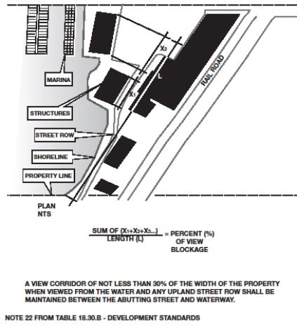
(Ord. 652 § 1 (Exh. A), 2015).
18.30.050 Agriculture.
A. Applicability. Agriculture includes, but is not limited to, the commercial production of horticultural, viticultural, floricultural, dairy, apiary, vegetable, or animal products or of berries, grain, hay, straw, turf, seed, or Christmas trees not subject to the excise tax imposed by RCW 84.33.100 through 84.33.140; or livestock, that has long-term commercial significance as well as the other definitions of agricultural use found in WAC 173-26-020(3). In all cases, the use of agriculture-related terms shall be consistent with the specific meanings provided in WAC 173-26-020. There are no agricultural lands or operations within the City’s shoreline jurisdiction.
B. Policies.
1. Commercial agriculture is not compatible with the City’s shoreline environment designations.
2. New agricultural uses should be prohibited.
C. Regulations.
1. The creation or establishment of new agricultural land, operations or activities is prohibited.
(Ord. 652 § 1 (Exh. A), 2015).
18.30.060 Aquaculture.
A. Applicability. Aquaculture is the farming or culturing of fish, shellfish or other aquatic plants and animals in lakes, streams, marine waters and other natural or artificial water bodies. Aquaculture does not include the harvest of wild geoduck associated with the State-managed wildstock geoduck fishery or activities on private property for personal consumption.
There are no aquaculture activities existing within the shoreline jurisdiction. Aquaculture activities are not anticipated to occur within shoreline jurisdiction; in the southern half of University Place, the sale for human consumption of commercial shellfish is currently prohibited by the State Department of Health.
B. Policies.
1. Some forms of aquaculture are dependent on the use of the water area; when consistent with control of pollution and prevention of damage to the environment, water-dependent aquaculture is an acceptable use of the water area. Future aquaculture uses are not anticipated within the City’s shoreline jurisdiction; however, some scale or form of aquaculture may be appropriate in locations within the City of University Place.
2. Aquaculture related to the recovery of native populations should be encouraged.
3. Development of aquaculture facilities and associated activities should assure no net loss to shoreline ecological functions or processes. Aquaculture facilities should be designed and located so as not to spread disease to native aquatic life, establish new nonnative species which cause significant ecological impacts, or significantly impact the aesthetic qualities of the shoreline or views from upland properties.
4. The City may support aquaculture uses and developments that:
• Protect or improve water quality; and
• Avoid and minimize damage to forage fish spawning areas and important nearshore habitats such as eelgrass and macroalgae; and
• Minimize interference with navigation and normal public use of surface waters; and
• Minimize the potential for cumulative adverse impacts, such as those resulting from in-water structures/apparatus/equipment, land-based facilities, and substrate disturbance/modification (including rate, frequency and spatial extent).
5. Aquaculture use and development should locate in areas where biophysical conditions, such as tidal flow, currents, water temperature and depth, will minimize adverse impacts to shoreline ecological functions.
C. Regulations.
1. Aquaculture may be authorized when part of an approved restoration or habitat management plan and when it complies with the provisions of UPMC 18.25.070.
2. Aquaculture for the purpose of recovering native populations may be authorized when authorized by the Department of Fish and Wildlife and/or other State or Federal agencies having jurisdiction. Fish hatchery facilities are a permitted use in all shoreline environment designations when they comply with all other applicable provisions of this Program.
3. Commercial shellfish and net pen/finfish aquaculture is prohibited in the Natural designation. In all other instances, commercial aquaculture shall be a conditional use.
4. Commercial aquaculture involving development of mini-seed nurseries, including those which use FLUPSY2 technology, are limited in size to those which can be installed in a marina slip or within an existing boathouse. No more than 10 percent of the slips at a marina shall be occupied by commercial aquaculture to ensure conflicts with existing water-dependent recreational uses are minimized.
5. Commercial aquaculture is allowed as a conditional use as outlined in Table 18.30.A where it can be located, designed, constructed, and managed to avoid all of the following:
• A net loss of shoreline ecological functions.
• Spreading diseases to native aquatic life.
• Adversely impacting native eelgrasses and macroalgae species.
• Significantly conflicting with navigation and public access.
6. Aquaculture facilities shall identify and use best management practices to minimize impacts such as light and noise from the construction and management of the facilities.
7. New aquatic species that are not previously cultivated in Washington State shall not be introduced into City waters without prior written approval of the Washington Department of Fish and Wildlife, including import and transport permits under WAC 220-76-100 and 220-72-076.
8. Aquaculture wastes shall be disposed of in a manner that will ensure compliance with all applicable governmental waste disposal standards, including but not limited to the Federal Clean Water Act, Section 401, and Chapter 90.48 RCW, Water Pollution Control. No garbage, wastes, or debris shall be allowed to accumulate at the site of any aquaculture operation.
9. The rights of treaty tribes to aquatic resources within their usual and accustomed areas shall be addressed through direct coordination between the project proponent and the affected tribe(s) through the permit review process.
10. Applicants shall include in their shoreline permit applications all information required by State and Federal permit applications for new and expanded aquaculture uses and development. Additional studies or information may be required by the City, which may include but are not limited to monitoring and adaptive management plans and information on ecological and visual impacts. For floating and above-water facilities, the City shall reserve the right to require that a visual impact analysis be conducted using a method approved by the City. Generally, the methods for identifying and analyzing potential visual and cumulative impacts will follow the principles in the Aquaculture Siting Study, Washington State Department of Ecology publication number 86-10-000 (October 1986).
11. Aquaculture structures and activities that are not water-dependent (e.g., warehouses for processing or storage of products and parking lots) shall be located landward of vegetation conservation areas and critical area buffers, and shall be located, designed and constructed to avoid and minimize detrimental adverse impacts to the shoreline.
12. Aquaculture activities and facilities shall be located where they do not adversely impact forage fish spawning areas, native eelgrass and microalgae species, or other critical saltwater habitats, priority species or species of concern, or habitat for such species as outlined in UPMC 18.25.070(D) and (E).
13. When a shoreline permit is issued for a new aquaculture use or development, that permit shall apply to the initial siting, construction, and planting or stocking of the facility or farm. Authorization to conduct such activities shall be valid for a period of five years with a possible extension. After the aquaculture use or development is established under the shoreline permit, continued operation of the use or development, including, but not limited to, maintenance, harvest, replanting, restocking or changing the culture technique or species cultivated shall not require a new, renewed or revised permit unless otherwise provided in the conditions of approval or this Program. Permit revisions shall proceed in accordance with WAC 173-27-100. Changing of the species cultivated shall be subject to applicable standards of this Program.
14. A new permit is required when:
a. The physical extent of the use or development or associated overwater coverage is expanded by more than 10 percent compared to the conditions that existed as of the effective date of this SMP. If the amount of expansion or change in overwater coverage exceeds 10 percent, the revision or sum of the revision and any previously approved revisions shall require that the applicant apply for a new permit; or
b. The use or development proposes to cultivate a species not previously cultivated within University Place’s jurisdictional waters; or
c. New chemicals not previously approved as part of the existing permit are proposed for use.
15. Floating/hanging aquaculture structures and associated equipment, except navigational aids, shall use colors and materials that blend into the surrounding environment in order to minimize visual impacts.
16. Aquaculture that involves significant risk of cumulative adverse effects on water quality, sediment quality, benthic and pelagic organisms, and/or wild fish populations through potential contribution of antibiotic-resistant bacteria, or escapement of nonnative species, or other adverse effects on ESA-listed species shall not be permitted.
17. Additional standards for commercial geoduck aquaculture:
a. In addition to the standards above, commercial geoduck aquaculture shall only be allowed where sediments, topography, land and water access support geoduck aquaculture operations without significant clearing or grading.
b. All permits shall take into account that commercial geoduck operators have the right to harvest geoduck once planted.
c. All subsequent cycles of planting and harvest shall not require a new CUP, subject to WAC 173-27-100.
d. A single CUP may be submitted for multiple sites within an inlet, bay or other defined feature, provided the sites are all under control of the same applicant and within the Program’s jurisdiction.
e. Commercial geoduck aquaculture workers shall be allowed to accomplish on-site work during low tides, which may occur at night or on weekends. Where such activities are necessary, noise and light impacts to nearby residents shall be mitigated to the greatest extent practicable.
f. Where an applicant proposes to convert existing non-geoduck aquaculture to geoduck aquaculture, a conditional use permit shall be required.
g. In addition to the requirements in WAC 173-26-241(3)(b), proposals and applications for commercial geoduck aquaculture shall comply with and contain all of the items identified in WAC 173-26-241(3)(b)(iv).
(Ord. 652 § 1 (Exh. A), 2015).
18.30.070 Boating facilities.
A. Applicability. The University Place community has had a long and continuous history of investing in and utilizing boating facilities located in the vicinity of Day Island. These facilities and activities are expected to continue. In addition, the construction of new boating facilities is anticipated to occur in accordance with the Chambers Creek Properties Master Site Plan. The provisions in this section apply to boating facilities allowed within the Day Island Medium Intensity, Urban Conservancy, and Shoreline Residential shoreline environments. These provisions do not, however, apply to boating facilities serving four or fewer single-family residences.
B. Policies.
1. Boating facilities that are water-dependent uses, including marinas and launch ramps, should be given priority for shoreline location.
2. Boating facilities and their accessory uses should be located, designed, constructed and maintained to achieve the following:
a. Protection of shoreline ecological functions and system-wide processes. When impacts cannot be avoided, mitigate to assure no net loss to shoreline ecological functions;
b. Maintenance and use of navigable waters, public access areas, and recreational opportunities, including over-water facilities;
c. Minimization of adverse impacts to adjacent land uses such as noise, light and glare, aesthetics, and public visual access; and
d. Minimization of adverse impacts to other water-dependent uses.
3. Development of new boating facilities should be coordinated with public access and recreation plans and should be co-located with other compatible water-dependent uses where feasible. Affected parties and potential partners should be included in the planning process.
4. New and expanded boating facilities should provide public shoreline access in accordance with UPMC 18.25.050 and provide for multiple uses including water-related uses, to the extent compatible with shoreline ecological functions and processes.
5. Upland boat storage is preferred over new in-water moorage.
6. New covered moorage should be prohibited.
7. Pilings treated with creosote or other similarly toxic materials should be replaced with steel or concrete pilings to minimize adverse impacts to water quality. Unused or derelict pilings should be removed in order to minimize continuing contamination of shoreline waters, consistent with the water quality provisions in UPMC 18.25.120.
8. Live-aboard vessels should only be permitted where adequate marina facilities exist to prevent impacts to water quality.
C. Regulations – General.
1. Marinas and launch ramps shall be designed not to retard or negatively influence flushing characteristics.
2. Marinas and boat launch ramps shall be located only on stable shorelines where water depths are adequate to avoid the net loss of shoreline ecological functions and processes, and eliminate or minimize the need for additional offshore or foreshore channel construction dredging, maintenance dredging, spoil disposal, filling, beach feeding and other river, harbor, and channel maintenance activities.
3. All boating facilities, including marinas and boat yards, shall utilize effective measures to prevent the release of oil, chemicals, or other hazardous materials into the water.
4. New and expanded marinas and boat launches shall provide public access in accordance with UPMC 18.25.050.
5. Boating facilities shall be located where parking and access can be provided without causing adverse impacts to adjacent properties or shoreline ecological functions.
6. Garbage/recycling facilities shall be provided at marinas and boat launching facilities.
7. Restroom facilities shall be provided at marinas and boat launching facilities during hours of operation.
8. Lighting for boating facilities shall be designed to minimize light and glare, especially where it is visible to adjacent properties and properties across the water. Illumination levels shall be the minimum necessary for the intended use. All light fixtures shall be fully shielded and oriented to prevent spillover off site. Lighting shall not be pointed directly at or into the water.
9. Impacts to navigation shall be avoided to the maximum extent feasible.
10. To preserve views of the water and minimize impacts on wildlife, fences shall have a visually open design (e.g., post and rail, or picket design) with at least 50 percent of the fence open for the continuous length of the fence. In exception to this requirement, the decision-maker may authorize fencing that is less than 50 percent open when such fencing is intended to screen refuse, recycling or storage facilities where such screening would enhance project aesthetics and not unduly compromise views of the water.
D. Regulations – Boat Launch Ramps.
1. Boat launch ramps shall be located, designed, constructed and maintained in accordance with the mitigation sequence and to reduce impacts to the shoreline. Preferred ramp designs, in order of priority, are:
a. Open grid designs with minimum coverage of beach substrate;
b. Seasonal ramps that can be removed and stored upland;
c. Structures with segmented pads and flexible connections that leave space for natural beach substrate and can adapt to change in beach profile; and
d. Concrete or compacted slope.
2. Ramps shall be located, constructed and maintained where alterations to the existing foreshore slope are not required, whenever feasible.
E. Regulations – Marinas.
1. New marinas and modifications to existing marinas are allowed only when the new or modified facilities are consistent with this Shoreline Program and only when the proponent demonstrates to the City’s satisfaction that all of the following conditions are met:
a. The proposed location or modification is the least environmentally damaging alternative, and areas of intact shoreline ecological functions and processes are avoided;
b. Hard armoring is not used;
c. Potential adverse impacts on shoreline processes and ecological functions are mitigated to achieve no net loss;
d. The project restores or enhances native vegetation within the VCA adjoining the new or modified marina to the extent practicable in accordance with UPMC 18.25.100;
e. The area has adequate water circulation and flushing action and the marina is designed so that it does not negatively influence flushing characteristics;
f. The proposed location will not require excavation and/or filling of wetlands or stream channels; and
g. Suitable public infrastructure is available, or can be made available by project completion, to support the marina.
2. Where authorized, new marinas and modifications to existing marinas shall be designed, constructed and operated as follows:
a. Floating structures shall be designed to prevent grounding on tidelands. Floats shall not rest on the substrate at any time. Stoppers or stub pilings shall be used to keep the bottom of the float at least one foot above the level of the substrate;
b. Piers and other structures shall be located, sized, and designed to minimize shading of nearshore aquatic habitats and species pursuant to the requirements set forth in UPMC 18.35.050;
c. Solid structures shall be designed to provide fish passage through and along the shallow water fringe;
d. Public access amenities shall be provided pursuant to UPMC 18.25.050, consistent with all relevant constitutional and other limitations that apply to regulations that are placed on private property, including the nexus and proportionality requirements. The location and design of public access shall be determined based on a given location and the public access needs in the vicinity of the marina. Existing public access shall not be adversely impacted;
e. Vessels are prohibited from extended mooring on waters of the State except as allowed by applicable State regulations and unless a lease or permission is obtained from the State and impacts to navigation and public access are mitigated;
f. Marinas shall provide restrooms and solid waste receptacles to accommodate marina users during business hours, and shall have facilities and established procedures for the discharge of solid waste or sewage, other than discharge into the water;
g. Marinas shall provide pump-out, holding and/or treatment facilities for sewage contained on boats or vessels;
h. Marina operators shall post all regulations pertaining to handling and disposal of waste, sewage, fuel and oil or toxic materials where they can be easily read by all users; and
i. Marinas shall have facilities and established procedures for the containment and recovery of spilled petroleum or toxic products.
3. New marinas and modifications to existing marinas that involve breakwaters shall meet all of the following design criteria:
a. Breakwaters built waterward in a perpendicular plane to the shoreline shall not be allowed as a continuous one-piece structure unless space limitations preclude the construction and use of a breakwater comprised of two or more segments;
b. The toe of a shore breakwater (jetty) may extend seaward to the MLLW, but shall not extend seaward more than 250 feet from mean higher high water;
c. Shore breakwaters shall have a minimum slope of one and one-half feet horizontal to one foot vertical throughout; slope restrictions do not apply to isolated breakwaters beyond the line of extreme low tide;
d. The breach (opening) between a shore breakwater and a detached breakwater shall not be less than 20 feet in width measured at the toe of the slope;
e. Breaches shall be maintained at or below marina depth to provide adequate fish passage;
f. Breaches may also be used as navigational channels;
g. Marina openings shall be sized (depth and/or width) so as to ensure proper circulation inside the marina configuration and exchange with the outside bay. To facilitate this exchange, the volume of the tidal prism (water present between mean low and mean high tide) shall be not less than 50 percent of the total volume of the basin;
h. The depth of the openings shall be at least as deep as the average depth of the marina; and
i. Openings may be baffled to protect the marina against wave action but in no instance should the baffling impede water circulation or fish movement.
F. Regulations – Dry Upland Storage.
1. New marinas and modifications to existing marinas that provide dry upland storage shall minimize the use of shoreline area for such storage unless:
a. No suitable upland locations exist for such facilities outside of the shoreline area;
b. It can be demonstrated that wet moorage would result in fewer impacts to ecological functions and processes; or
c. It can be demonstrated that wet moorage would enhance public use of the shoreline.
2. New and modified marinas shall use a launch mechanism that protects shoreline ecological functions and processes.
3. Dry upland storage shall comply with the following:
a. The structure shall not exceed the maximum height set forth in Table 18.30.B;
b. The facility shall be visually compatible with the surrounding environment; and
c. The facility shall comply with VCA buffer and VCA setback requirements, be located away from the shoreline to the greatest extent practicable, and be landscaped with native vegetation to provide a visual and noise buffer for adjoining dissimilar uses or scenic areas.
G. Regulations – Covered Moorage.
1. New over-water covered moorage and the expansion of existing covered moorage is prohibited.
2. Existing over-water covered moorage may be modified or replaced, but not extended in terms of cumulative footprint, shading of water, and average height.
3. Covered moorage shall be located, designed, constructed and maintained in accordance with the mitigation sequence in UPMC 18.25.070(C)(2) and to reduce impacts to the shoreline.
H. Regulations – Live-Aboard Vessels.
1. No vessel berthed in a marina or yacht club shall be used as a place of residence except as authorized by the marina operator or yacht club in conjunction with a permit from the City.
2. No more than 15 percent of the slips at a marina or yacht club shall be occupied by live-aboard vessels. Any marina or yacht club with live-aboard vessels shall require:
a. That all live-aboard vessels are connected to utilities that provide sewage conveyance to an approved disposal facility; or
b. That marina operators, yacht clubs or live-aboard vessels are contracted with a private pump-out service company that has the capacity to adequately dispose of live-aboard vessel sewage; or
c. That a portable pump-out facility is readily available to live-aboard vessel owners; or
d. That a fixed pump-out facility approved by the local sewer service provider is located within the marina or yacht club;
e. That all live-aboard vessels shall have access to utilities that provide potable water;
f. That live-aboard vessels are of the cruising type, and are kept in good repair and seaworthy condition.
3. Marinas or yacht clubs with live-aboard vessels shall only be permitted where compatible with the surrounding area and where adequate sanitary sewer facilities exist (as listed in subsections (H)(2)(a), (b), (c) and (d) of this section) within the marina or yacht club and on the live-aboard vessel.
(Ord. 652 § 1 (Exh. A), 2015).
18.30.080 Commercial.
A. Applicability. The provisions in this section apply to all commercial uses and development types allowed within the Day Island Medium Intensity shoreline jurisdiction. Commercial use provisions apply to business uses or activities at a scale greater than a home occupation involving retail or wholesale marketing of goods and services. Examples include, but are not limited to, hotels, motels, grocery stores, restaurants, shops, offices, and indoor recreation facilities.
B. Policies.
1. Preference should be given to water-dependent commercial uses, then to water-related, and then water-enjoyment commercial uses in shoreline jurisdiction. Non-water-oriented commercial uses should be prohibited unless they are integrated into mixed use development that includes water-oriented uses or navigation is severely limited, and the use provides a significant public benefit consistent with the objectives of the Act.
2. The preferred location for non-water-oriented commercial uses is in mixed use areas as far from the shoreline as possible.
3. Commercial development should be located, designed, and operated to avoid and minimize adverse impacts on shoreline ecological functions and processes. Unavoidable impacts should require mitigation.
4. Commercial development should provide public access to shoreline beaches, docks, walkways, and viewing areas, unless such improvements are demonstrated to be incompatible due to reasons of safety, security, or impact to the shoreline environment.
5. Commercial development should be designed to be visually compatible with adjacent and upland properties and so that the height, bulk, and scale do not impair views.
6. Commercial development should implement low-impact development techniques to the maximum extent feasible.
C. Regulations – General.
1. The construction of new over-water commercial buildings or the expansion of existing over-water commercial buildings is prohibited.
2. Public access shall be provided for commercial use and development pursuant to UPMC 18.25.050.
3. All commercial use and development shall preserve and enhance native shoreline vegetation; or if vegetation is degraded or none is present, restore or enhance in accordance with the vegetation conservation requirements in UPMC 18.25.100.
4. A visual impact assessment shall be prepared for commercial buildings proposed to be greater than 35 feet in height from average grade level in accordance with UPMC 18.25.110(E).
5. Home occupations, as defined in UPMC 19.10.030, are not considered to be commercial uses.
6. The following information shall be required at the time of shoreline development permit application or shoreline conditional use permit application for commercial uses:
a. Evidence of water orientation or integration with mixed use development;
b. Demonstration of cooperative use of service facilities by multiple users, where feasible;
c. Information on transportation and utility service corridors, traffic circulation, access to the facility, and the impacts of the proposed project on transportation, circulation and navigation in the area;
d. The design and location of public access;
e. Analysis of the impact upon and alteration to land forms;
f. Methods for treatment and control of waste disposal including any proposed storm or sanitary sewer outfalls;
g. Analysis of the impact of the proposed project upon ground water, hydrology, drainage patterns and soil erosion;
h. Analysis of air quality, noise levels, and light pollution impacts;
i. Analysis of impacts to shoreline ecological functions and processes; and
j. Mitigation plan to address any unavoidable adverse impacts to the shoreline environment.
7. To preserve views of the water and minimize impacts on wildlife, fences shall have a visually open design (e.g., post and rail, or picket design) with at least 50 percent of the fence open for the continuous length of the fence. In exception to this requirement, the decision-maker may authorize fencing that is less than 50 percent open when such fencing is intended to screen refuse, recycling or storage facilities where such screening would enhance project aesthetics and not unduly compromise views of the water. No fence shall extend waterward of the ordinary high water mark.
D. Regulations – Water-Oriented Use and Development.
1. Water-oriented commercial use and development shall be allowed when the applicant demonstrates that:
a. There will be no net loss of shoreline ecological functions or processes;
b. There will be no significant adverse impact on other shoreline uses, resources and/or values such as navigation, recreation, public access, and design compatibility; and
c. The design, layout, and operation of the use or development meet the definition of water-oriented uses per the definitions of the Shoreline Program.
2. Water-enjoyment and water-related commercial uses shall provide public access and ecological restoration where feasible and avoid impacts to existing navigation, recreation, and public access.
E. Regulations – Non-Water-Oriented Use and Development.
1. Non-water-oriented commercial uses are not allowed unless they meet one of the following criteria:
a. The use is part of a mixed-use project that includes water-oriented uses and provides a significant public benefit in the form of public access and ecological restoration.
b. Navigability is severely limited at the proposed site and the commercial use provides a significant public benefit in the form of public access and ecological restoration.
c. The use is within the shoreline jurisdiction but physically separated from the shoreline by a separate property, public right-of-way, or existing use. For the purposes of this Shoreline Program, public access trails and facilities do not constitute a separation.
2. Non-water-oriented commercial buildings or uses shall be set back a minimum of 60 feet from the ordinary high water mark in the Day Island Medium Intensity shoreline environment. The area between these buildings or uses and the ordinary high water mark shall be used for water- oriented use and development, additional public access or shoreline restoration. Buildings that contain a mix of non-water-oriented uses and water-oriented uses may be set back a minimum of 35 feet from the ordinary high water mark in the Day Island Medium Intensity shoreline environment, provided the use of the building is predominantly water-oriented.
3. The applicant shall demonstrate that the proposed non-water-oriented commercial or mixed use will not:
a. Result in a net loss of shoreline ecological functions or processes; or
b. Have significant adverse impact on other shoreline uses, resources and/or values such as navigation, recreation, public access, and design compatibility.
4. The construction of new non-water-oriented commercial buildings or uses or the expansion of existing non-water-oriented commercial buildings or uses shall require a shoreline conditional use permit.
5. Non-water-dependent commercial uses over water are prohibited except in existing structures, and where necessary to support water-dependent uses.
(Ord. 652 § 1 (Exh. A), 2015).
18.30.090 Forest practices.
A. Applicability. Forest practices are incompatible with goals for shoreline areas within the City boundaries.
B. Policies.
1. Forest practice activities should be prohibited within all shoreline environment designations.
C. Regulations.
1. Forest practices are prohibited in all shoreline environment designations.
2. For the purpose of this Shoreline Program, preparatory work associated with the conversion of land to nonforestry uses and/or developments shall not be considered forest practices. Such work shall be reviewed in accordance with the applicable provisions for the proposed non-forestry use and the general provisions of this Shoreline Program, including vegetation conservation.
(Ord. 652 § 1 (Exh. A), 2015).
18.30.100 Industrial.
A. Applicability. The provisions in this section apply to all industrial uses and development types allowed within the Day Island Medium Intensity shoreline environment in accordance with Table 18.30.A. Industrial use provisions apply to activities involving the production, processing, storage, movement, servicing, or repair of goods and materials.
B. Policies.
1. Preference should be given to water-dependent industrial uses first, then to water-related industrial uses over non-water-oriented industrial uses.
2. The preferred location for non-water-dependent industrial uses is within mixed use areas as far from the shoreline as feasible.
3. Water-dependent or water-related industrial marine uses should be located in areas already established or zoned for mixed use.
4. Industrial use and development should be located, designed, and operated to avoid and minimize adverse impacts on shoreline ecological functions and processes.
5. Transportation and utility corridors serving industrial uses should be located away from the water’s edge to minimize ecological impacts and reduce the need for waterfront signs and other infrastructure.
6. Industrial development and redevelopment should be encouraged to locate where environmental cleanup and restoration of the shoreline area can be accomplished.
7. The cooperative use of docking, parking and storage facilities on mixed use properties should be encouraged.
C. Regulations.
1. Water-dependent or water-related industrial development shall be authorized when the applicant demonstrates that:
a. It will not cause a net loss of shoreline ecological functions or processes;
b. It will not have significant adverse impacts on other shoreline uses, resources and/or values such as navigation, recreation and public access; and
c. The design, layout, and operation of the use or development meet the definition of water-dependent or water-related uses per the definitions of this Shoreline Program.
2. Non-water-oriented industrial uses are not allowed unless they meet one or more of the following criteria:
a. The use is part of a mixed-use project that includes water-dependent uses and provides a significant public benefit in the form of public access and ecological restoration;
b. Navigability is severely limited at the proposed site and the industrial use provides a significant public benefit in the form of public access and ecological restoration; or
c. The use is within the shoreline jurisdiction but physically separated from the shoreline by a separate property, public right-of-way, or existing use, and provides a significant public benefit with respect to the public access and restoration goals of this Shoreline Program. For the purposes of this Shoreline Program, public access trails and facilities do not constitute a separation.
3. Public access shall be provided for industrial use and development pursuant to UPMC 18.25.050.
4. All industrial use and development shall preserve and enhance native shoreline vegetation; or if vegetation is degraded or none is present, restore or enhance in accordance with the vegetation conservation requirements in UPMC 18.25.100.
5. The construction of new non-water-oriented industrial buildings or uses or the expansion of existing non-water-oriented industrial buildings or uses shall require a shoreline conditional use permit.
6. Non-water-oriented industrial buildings or uses shall be set back a minimum of 60 feet from the ordinary high water mark. The area between these buildings or uses and the ordinary high water mark shall be used for water-oriented use and development, additional public access or shoreline restoration. Buildings that contain a mix of non-water-oriented uses and water-oriented uses may be set back a minimum of 35 feet from the ordinary high water mark provided the use of the building is predominantly water-oriented.
7. The cooperative use of docking, parking and storage facilities on mixed use properties is required, where feasible.
8. Industrial use or development shall be located and designed to minimize the need for initial or recurrent dredging, filling or other harbor and channel maintenance activities.
9. Industrial use or development shall include the capability to contain and clean up spills, leaks, discharges, or pollutants, and shall be responsible for any water or sediment pollution they cause.
10. The following information shall be required at the time of shoreline development permit application or shoreline conditional use permit application for industrial uses:
a. Evidence of water orientation or integration with mixed use development;
b. Demonstration of cooperative use of service facilities by multiple users, where feasible;
c. Information on transportation and utility service corridors, traffic circulation, access to the facility, and the impacts of the proposed project on transportation, circulation and navigation in the area;
d. The design and location of public access;
e. Analysis of the impact upon and alteration to land forms;
f. Methods for treatment and control of waste disposal including any proposed storm or sanitary sewer outfalls;
g. Demonstration that the location of storing chemicals or other hazardous materials is as far from the shoreline as feasible;
h. Analysis of the impact of the proposed project upon ground water, hydrology, drainage patterns and soil erosion;
i. Analysis of air quality, noise levels, and light pollution impacts;
j. Analysis of impacts to shoreline ecological functions and processes; and
k. Mitigation plan to address any unavoidable adverse impacts to the shoreline environment.
11. The construction of new over-water industrial buildings or the expansion of existing, over-water industrial buildings is prohibited.
12. To preserve views of the water and minimize impacts on wildlife, fences shall have a visually open design (e.g., post and rail, or picket design) with at least 50 percent of the fence open for the continuous length of the fence. In exception to this requirement, the decision-maker may authorize fencing that is less than 50 percent open when such fencing is intended to screen refuse, recycling or storage facilities where such screening would enhance project aesthetics and not unduly compromise views of the water. No fence shall extend waterward of the ordinary high water mark.
(Ord. 652 § 1 (Exh. A), 2015).
18.30.110 Mining.
A. Applicability. Chambers Creek Properties was the site of extensive gravel mining for over a century until commercial mining operations ceased in 2003. Site work associated with the conversion of this formerly mined land is authorized to continue under the Chambers Creek Properties Master Site Plan in order to support redevelopment and reclamation. Such activities, when conducted in accordance with the Mining Reclamation Plan approved by the Washington State Department of Natural Resources, shall not be considered mining. New mining is incompatible with goals for shoreline areas within the City boundaries.
B. Policies.
1. New mining should be prohibited.
C. Regulations.
1. Mining is prohibited in all shoreline environment designations.
2. For the purpose of this Shoreline Program, site work associated with the redevelopment and reclamation of the previously mined Chambers Creek Properties site is authorized to continue under the Chambers Creek Properties Master Site Plan and shall not be considered mining. Such work shall be reviewed in accordance with the applicable provisions for the proposed nonmining use and the general provisions of this Shoreline Program, including vegetation conservation.
(Ord. 652 § 1 (Exh. A), 2015).
18.30.120 Recreation.
A. Applicability. Recreational uses include passive activities, such as walking, viewing and fishing. Recreational development also includes facilities for active uses, such as swimming, boating, and other outdoor recreation uses. This section applies to both public and private noncommercial shoreline recreational facilities (excluding that which is incidental to private residences) in the City.
B. Policies – General.
1. Public recreation is a preferred use of the shoreline. Recreational uses and developments that facilitate the public’s ability to reach, touch, and enjoy the water’s edge, to travel on the waters of the State, and to view the water and shoreline are preferred. Where appropriate, such facilities should be dispersed along the shoreline in a manner that supports more frequent recreational access and aesthetic enjoyment for a substantial number of people.
2. Water-oriented recreational uses, such as boating, swimming beaches, and wildlife viewing, should have priority over non-water-oriented recreation uses, such as sports fields. A variety of compatible recreation experiences and activities should be encouraged to satisfy diverse recreational needs.
3. Recreational developments and plans should promote conservation of the shoreline’s natural character, ecological functions and processes.
4. Shoreline recreational development should be planned, designed and implemented consistent with the growth projections, level-of-service standards, and goals established in the City’s Comprehensive Plan, the Chambers Creek Properties Master Site Plan, and the Parks, Recreation and Open Space Plan.
5. Recreation facilities should be integrated and linked with linear systems, such as hiking paths, sidewalks, bicycle paths, easements, and/or scenic drives.
6. Recreation facilities should incorporate public education and interpretive signs regarding shoreline ecological functions and processes, historic and cultural heritage.
7. Recreation facilities should be designed to preserve, enhance, or create scenic views and vistas.
8. Commercial recreation facilities should be consistent with the provisions for commercial development (see UPMC 18.30.080).
C. Policies – Shoreline Environments.
1. Marine Deepwater. New recreational uses and structures should be limited to public access/recreational improvements designed to provide access to the shoreline for a substantial number of people. New over-water structures should be authorized only when they will provide significant public benefits.
2. Natural. Private and/or public enjoyment of natural shoreline areas should be encouraged and facilitated through low-intensity recreational uses such as walking/hiking trails; provided, that no significant ecological impact on the area will result. The Chambers Creek Canyon should be retained in its natural state with only those minimal improvements necessary to support public access. Protection of ecological functions should have priority over public access, recreation and other development objectives whenever a conflict exists. New over-water structures should be authorized only when they will provide significant public benefits. Non-water-related or enjoyment recreation uses should be allowed only when the use is passive and consistent with the Chambers Creek Properties Master Site Plan, when applicable.
3. Urban Conservancy. Public access and public recreation objectives should be implemented whenever feasible and adverse ecological impacts can be avoided. Public access along the marine shoreline should be provided, preserved, or enhanced consistent with this policy and the Chambers Creek Properties Master Site Plan, when applicable. New over-water structures should be authorized only when they will provide significant public benefits. Non-water-related or enjoyment recreation uses should be allowed only when consistent with the Chambers Creek Properties Master Site Plan, when applicable.
4. Shoreline Residential. Public outdoor recreation facilities should be encouraged if compatible with the character of the area. Preferred uses include water-enjoyment recreation facilities that provide opportunities for people to access and enjoy the shoreline. New over-water structures should be authorized only when they will provide significant public benefits.
5. Day Island Medium Intensity. A mix of private and public park and recreation facilities, linked by a comprehensive public access system, should be encouraged. Pedestrian and bicycle paths should be permitted as public access opportunities, where appropriate. Non-water-related or enjoyment recreation uses should be allowed only when the use is part of a mixed use project that includes water-oriented uses and provides a significant public benefit in the form of public access and ecological restoration.
D. Regulations – General.
1. Park and recreation facilities may be used for events and temporary uses when the applicant can demonstrate that the proposed use will not damage the shoreline. Structures associated with such uses shall be located as far landward as feasible and shall be removed immediately after the event is over. Shoreline areas shall be returned to pre-event conditions.
2. Recreational use and development shall include appropriate mitigation to minimize light and noise impacts on adjoining properties. Such measures shall include, but not be limited to, fencing, vegetative screening, increased setbacks, limited hours of operation, and other appropriate measures. Where lighting is used, the illumination levels shall be the minimum needed for the intended use. Cut-off fixtures shall be used, where necessary, to prevent spillover of light.
3. Fragile and unique shoreline areas with valuable ecological functions, such as wildlife habitats, shall be used only for nonintensive recreation activities that do not involve the construction of structures.
4. Recreation developments such as playfields that require periodic use of fertilizers, pesticides or other chemicals, or that support high-intensity activities as a primary use, such as sporting events, shall be located outside of shoreline jurisdiction, when feasible.
5. A new or expanded shoreline recreational development or use that does not provide on-site public access may be authorized, provided the applicant has demonstrated, and the City has determined, that one or more of the conditions listed in UPMC 18.25.050(H)(2) exist.
6. All recreation use and development shall preserve and enhance native shoreline vegetation or if vegetation is degraded or none is present, restore or enhance in accordance with the vegetation conservation requirements in UPMC 18.25.100.
7. Recreation buildings proposed to be greater than 35 feet in height from average grade level shall prepare a visual impact assessment in accordance with UPMC 18.25.110(E).
8. The following information shall be required at the time of shoreline development permit application or shoreline conditional use permit application for recreation uses, when applicable:
a. Information on transportation and utility service corridors, traffic circulation, access to the facility, parking, and the impacts of the proposed project on transportation, circulation and navigation in the area;
b. The design and location of public access;
c. Analysis of the impact upon and alteration to land forms;
d. Methods for treatment and control of waste disposal including any proposed storm or sanitary sewer outfalls;
e. Analysis of the impact of the proposed project upon ground water, hydrology, drainage patterns and soil erosion;
f. Analysis of air quality, noise levels, and light pollution impacts;
g. Analysis of impacts to shoreline ecological functions and processes; and
h. Mitigation plan to address any unavoidable adverse impacts to the shoreline environment.
9. To preserve views of the water and minimize impacts on wildlife, fences shall have a visually open design (e.g., post and rail, or picket design) with at least 50 percent of the fence open for the continuous length of the fence. In exception to this requirement, the decision-maker may authorize fencing that is less than 50 percent open when such fencing is intended to screen refuse, recycling or storage facilities where such screening would enhance project aesthetics and not unduly compromise views of the water. No fence shall extend waterward of the ordinary high water mark.
10. Commercial recreational development shall be consistent with the provisions for commercial development in UPMC 18.30.080.
E. Regulations – Water-Related and Enjoyment.
1. Water-related or enjoyment recreation uses and development are preferred shoreline uses and shall be allowed when the applicant demonstrates that:
a. There will be no net loss of shoreline ecological functions or processes;
b. There will be no significant adverse impacts on other shoreline uses, resources and/or values such as navigation and public access;
c. Public access to the shoreline, including nonmotorized and pedestrian access, will be provided pursuant to UPMC 18.25.050; and
d. The proposal will protect existing native vegetation in the shoreline area and restore vegetation impacted by development activities.
F. Regulations – Non-Water-Oriented.
1. Non-water-oriented recreation uses are not allowed unless they meet one of the following criteria:
a. The use is part of a mixed use project located in the Day Island Medium Intensity shoreline environment that includes water-oriented uses and provides a significant public benefit in the form of public access and ecological restoration;
b. The use is within the shoreline jurisdiction but physically separated from the shoreline by a separate property, public right-of-way, or existing use. For the purposes of this Shoreline Program, public access trails and facilities do not constitute a separation;
c. The use is passive when located in the Natural shoreline environment; or
d. The use is consistent with the Chambers Creek Properties Master Site Plan, when applicable and located in the Urban Conservancy or Natural shoreline environment.
2. Non-water-oriented recreation buildings or uses shall be set back from the ordinary high water mark in accordance with the distances specified in Table 18.30.B. The area between these buildings or uses and the ordinary high water mark shall be used for water-related and enjoyment use, additional public access or shoreline restoration. Buildings that contain a mix of non-water-oriented and water-related and enjoyment uses may be set back from the ordinary high water mark in accordance with the distance specified in Table 18.30.B for “all other water-related recreational structures,” provided the use of the building is predominantly water-related and enjoyment.
(Ord. 652 § 1 (Exh. A), 2015).
18.30.130 Residential.
A. Applicability. Residential development means one or more buildings, structures, lots, parcels, or portions thereof, which are designed for and used or intended to be used to provide a place of abode for human beings. This includes the creation of new residential lots through land division and single-family, two-family and multifamily residences together with accessory uses and structures normally applicable to residential uses located landward of the ordinary high water mark including, but not limited to, a swimming pool, garages, a shed, fences, decks, driveways, utilities, a hot tub, a sauna, and grading that does not exceed 250 cubic yards and does not involve placement of fill in any wetland or waterward of the ordinary high water mark (WAC 173-27-040(2)(g)). Single-family and multifamily development is limited to those underlying zones that allow it and also subject to the requirements therein.
B. Policies.
1. All residential developments should be located, designed, and properly managed to avoid damage to the shoreline environment and avoid cumulative impacts associated with shoreline armoring, over-water structures, stormwater runoff, septic systems, vegetation clearing, and introduction of pollutants.
2. The overall density of development, lot coverage, setbacks, volume and height of structures should be designed to be compatible with adjoining uses and the physical capabilities of the shoreline and water.
3. Residential development, including the division of land and the construction of residential units, should be designed and located so that new or additional shoreline armoring will not be necessary to protect land or structures.
4. Dwelling units and accessory structures should be clustered to preserve natural features and minimize overall disturbance of the site.
5. New dwelling units and accessory structures, and additions thereto, should be set back from eroding shoreline areas so that the shoreline is not further eroded and structural improvements are not required to protect property.
6. New dwelling units and accessory structures, and additions thereto, should be set back from the top of steep slopes in accordance with the requirements of UPMC 17.15.055, so that structural improvements are not required to protect property.
7. New residential development of more than four lots or units should provide opportunities for public access.
8. New residential development should minimize impacts upon views to adjacent residential areas, in keeping with the Shoreline Management Act.
9. The City should encourage the use of alternative paving products for walkways, driveways, and patios, such as pervious pavers, as a mechanism for reducing impervious surfaces and surface water runoff.
10. New or expanded over-water residential development should be prohibited.
11. Limited expansion of existing overwater residential development should be allowed where the expansion is located to the landward side of the existing structure and does not increase over- water coverage.
12. Residential development should result in no net loss of ecological function.
13. Whenever possible, nonregulatory methods to protect, enhance and restore shoreline ecological functions should be encouraged for residential development.
14. Single-family residences should be identified as a priority use only when developed in a manner consistent with control of pollution and prevention of damage to the natural environment.
C. Regulations.
1. New residential development, including additions to existing structures, shall meet the development standards set forth in Table 18.30.B.
2. Residential development, including new subdivisions, shall be designed to:
a. Maintain or improve ecological functions and processes;
b. Preserve and enhance native shoreline vegetation; or if vegetation is degraded or none is present, restore or enhance in accordance with the vegetation conservation provisions of UPMC 18.25.100;
c. Control erosion and impacts to slope stability;
d. Avoid the use of shoreline armoring;
e. Minimize structural obstructions to normal public use and views of the shoreline and the water; and
f. Comply with critical area regulations in UPMC Title 17 as incorporated into this Shoreline Program, when applicable.
3. New primary residential structures are not allowed within a VCA.
4. Within the Shoreline Residential shoreline environment, new accessory structures and improvements are not allowed within a VCA except for pedestrian access authorized in UPMC 18.25.050(F), and uncovered single-family residential decks, patios, benches, tables, hot tubs, play equipment and other similar structures, and access paths subject to compliance with the vegetation conservation standards in UPMC 18.25.100.
5. Within the Day Island Medium Intensity, Urban Conservancy or Natural shoreline environments, new accessory structures and improvements are not allowed within the VCA.
6. New over-water residential development, including floating homes, shall be prohibited.
7. New residential development of more than four lots or units within shoreline jurisdiction shall provide public access for use by residents of the development and the general public and joint use for community recreational facilities. Public access shall be located, designed and managed in accordance with the provisions of UPMC 18.25.050.
8. Development proposals that exceed 35 feet in height must include an analysis of how the proposed structure(s) would impact the views of surrounding residents or the protected views set forth in UPMC 18.25.110. If the proposed structure(s) would block or significantly compromise the view of a substantial number of residences in adjoining areas, the City shall limit the height to 35 feet (30 feet for Day Island South Spit), or require design revisions or relocation to prevent the loss of views.
9. To preserve views of the water and minimize impacts on wildlife, residential fences are not allowed within VCAs located in the Natural environment. Fences located within the shoreline setback specified for each upland shoreline environment shall not exceed four feet in height and shall have a visually open design (e.g., post and rail, or picket design) with at least 50 percent of the fence open for the continuous length of the fence. If an existing dwelling encroaches into the shoreline setback, fence height may be increased to six feet for that portion of the fence that does not extend waterward of the existing building footprint. Fences located outside of the shoreline building setback may be increased to six feet in height, provided they comply with the fence height standards specified in UPMC 19.45.070 or other applicable design standards. No fence shall extend waterward of the ordinary high water mark.
10. When two or more undeveloped single-family legal building sites are contiguous within a shoreline, only a single joint-use dock with a common access easement may be authorized for use by those two or more residential units or lots.
11. For new multi-unit residential developments, only one single joint-use dock shall be allowed for the entire development.
12. Residential development shall result in no net loss of ecological function.
(Ord. 652 § 1 (Exh. A), 2015).
18.30.140 Transportation.
A. Applicability. Transportation facilities are those structures and developments that aid in land, air, and water surface movement of people, goods, and services. They include roads and highways, bridges (including pedestrian bridges), bikeways, railroads, public transportation facilities, and other related facilities. In the City, these uses (other than railroads) account for a minimal percentage of the shoreline land inventory. However, the impact of these facilities on shorelines can be substantial.
B. Policies.
1. All new or expanded transportation facilities should be designed and located to minimize impacts to shoreline ecological functions including riparian and nearshore areas, stream outfalls, steep slopes and natural vegetation.
2. The location and design of new or expanded roadways should not compromise:
a. Existing and planned shoreline public access; and
b. Existing and planned habitat restoration and enhancement projects.
3. Maintenance and repair of existing roads in shoreline jurisdiction should use all reasonable methods to minimize adverse impacts on nearby shorelines.
4. New and expanded transportation facilities should be designed and located to minimize the need for the following:
a. Structural shoreline protection measures;
b. Modifications to natural drainage systems; and
c. Waterway crossings.
5. Planning for transportation and circulation corridors should consider location of public access facilities, and be designed to promote safe and convenient access to those facilities.
6. Pedestrian trails and bicycle paths are encouraged where they are compatible with the natural character, resources, and ecology of the shoreline.
7. Piers and bridges for roads, pedestrian trails, bicycle paths, and railroads are preferred over the use of fill within the shoreline jurisdiction.
8. When transportation corridors are necessary within the shoreline jurisdiction, joint use corridors are preferred and encouraged for roads, utilities, and all forms of transportation/circulation.
C. Regulations.
1. New or expanded transportation facilities shall be kept to the minimum width necessary and located as far landward as possible.
2. Proponents of new or expanded roads shall demonstrate the following:
a. The need for a shoreline location and that no reasonable upland alternative exists;
b. The construction is designed to protect the adjacent shorelands against erosion, uncontrolled or polluting drainage, and other factors detrimental to the environment both during and after construction;
c. The proposed width is the minimum necessary for the intended purpose;
d. The project will be planned to fit the existing topography as much as possible, thus minimizing alterations to the natural environment;
e. That streams or natural drainage ways within the road corridor will be protected, and fish passage will not be impaired;
f. All debris, overburden and other waste materials from construction will be disposed of to prevent their entry into the adjoining water body;
g. The location and design of new roadways will not compromise existing and planned shoreline public access and existing or planned water-dependent uses, or compromise existing and planned habitat restoration or enhancement projects; and
h. The project will not result in the net loss of shoreline ecological functions or system-wide processes.
3. Transportation facilities shall be designed to cross shoreline areas by the shortest, most direct route feasible.
4. Access roads and/or drive lanes serving shoreline parcels shall be the minimum width necessary.
5. Bridges may be authorized within sensitive fish and wildlife habitat only if the following conditions are met:
a. An alternative alignment is not feasible;
b. The project is located or designed to minimize its impacts on the environment;
c. Adverse impacts are mitigated to achieve no net loss of shoreline ecological functions and system-wide processes;
d. Open-piling and piers required to construct the bridge may be placed waterward of the ordinary high water mark if no alternative method is feasible; and
e. All other applicable provisions of this Shoreline Program are met, including critical area regulations in UPMC Title 17 as incorporated into this Shoreline Program.
6. Trails or shared use paths, including boardwalks and pedestrian overpasses, may be allowed within a VCA or the required setback from the ordinary high water mark when constructed in accordance with UPMC 18.25.050(F). Restoration and enhancement shall be required to mitigate the impacts of such uses on the shoreline.
(Ord. 652 § 1 (Exh. A), 2015).
18.30.150 Utilities.
A. Applicability. Utilities include, but are not limited to, services and facilities that produce, transmit, store, process or dispose of electric power, gas, water, sewage, and communications. The provisions of this section apply to primary use and activities such as solid waste handling and disposal, water transmission lines, water reclamation plants, sewage treatment facilities and mains, power-generating or high voltage transmission facilities, gas distribution lines and storage facilities, stormwater mains and regional stormwater treatment facilities. On-site utilities serving a primary use, such as a water, sewer, or gas line to a residence, are accessory utilities and shall be regulated as part of the primary use rather than a separate utility facility.
B. Policies.
1. Utility facilities should be designed, located and maintained to minimize harm to shoreline ecological functions, preserve the natural landscape, and minimize conflicts with present and planned land and shoreline uses.
2. Expansions to existing sewage treatment and water reclamation plants should be compatible with recreational, residential, or other public uses of the water and shorelands.
3. Where water crossings are unavoidable, they should be located where they will have the least adverse ecological impact.
4. New primary utilities should be located outside of the shoreline jurisdiction unless no other feasible option exists. Where allowed, they should use existing transportation and utility sites, rights-of-way and corridors, rather than creating new corridors.
5. Utilities should be located and designed to avoid impacts to public recreation and public access areas, as well as significant historic, archaeological, cultural, scientific or educational resources.
6. The use of utility rights-of-way for public access to and along shorelines should be encouraged.
7. Utilities should be designed and installed in such a way as to avoid impacts to scenic views and aesthetic qualities of the shoreline area.
C. Regulations.
1. Utility facilities and transmission lines shall be designed and located to assure no net loss of shoreline ecological functions, preserve the natural landscape, and minimize conflicts with adjacent uses.
2. New public or private utilities, including non-water-oriented utility production and processing facilities, and all utility transmission facilities, shall be located as far landward of the ordinary high water mark as possible, preferably outside of the shoreline jurisdiction, unless:
a. The utility requires a location adjacent to the water;
b. Alternative locations are infeasible; or
c. Utilities are required for uses and activities authorized in this Shoreline Program.
3. Utility facilities shall avoid disturbance of unique and fragile areas, as well as wildlife spawning, nesting and rearing areas. Utility facility development shall result in no let loss of shoreline ecological functions. Mitigation shall be provided as necessary to meet this requirement.
4. On-site utilities serving a primary use, such as a water, sewer, or gas line to a residence, are accessory utilities and shall be considered part of the primary use.
5. Utilities that need water crossings shall be placed deep enough to avoid the need for bank stabilization and stream/riverbed filling both during construction and in the future due to flooding and bank erosion that may occur over time. Boring, rather than open trenches, is the preferred method of utility water crossings.
6. Where no other options exist, in-water utility corridors may be allowed, provided the corridor is located and designed to minimize impacts to shoreline ecology and processes, and adverse impacts are mitigated.
7. When feasible, utility lines shall use existing rights-of-way, corridors and/or bridge crossings and shall avoid duplication and construction of new parallel corridors in all shoreline areas.
8. Utility facilities shall be constructed using techniques that minimize the need for shoreline fill.
9. New utility installations shall be planned, designed and located to eliminate the need for structural shoreline armoring or flood hazard reduction measures.
10. Vegetation clearing during utility installation and maintenance shall be minimized, and disturbed areas shall be restored or enhanced following project completion.
11. Pipes that outfall directly into the water shall be located to minimize adverse impacts on shoreline ecological functions and processes.
12. Utility corridors shall be located and designed to protect scenic views. Where feasible, utilities shall be placed underground or alongside or under bridges, unless doing so would cause greater ecological impact or harm.
13. Stormwater facilities serving allowed uses should be located outside of the shoreline jurisdiction unless it can be demonstrated that no other feasible alternative exists.
14. To the greatest extent feasible, new utility systems shall be co-located with other existing or planned utilities, roadways and/or railways and/or placed within already-disturbed corridors whenever possible.
15. Through coordination with local government agencies and among utility providers, utility development shall provide for compatible, multiple uses of sites and rights-of-way. Such uses include shoreline access points, trail systems and other forms of recreation and transportation, providing such uses will not unduly interfere with utility operations, endanger public health and safety, or create a significant and disproportionate liability for the owner.
(Ord. 652 § 1 (Exh. A), 2015).