


Chapter 18.35
SHORELINE MODIFICATIONS
Sections:
18.35.020 Allowed shoreline modifications.
18.35.030 Dredging and dredge material disposal.
18.35.050 Moorage – Moorage buoys, docks (piers, ramps and floats) and recreational floats.
18.35.060 Restoration and enhancement.
18.35.070 Shoreline stabilization.
18.35.080 Breakwaters, jetties, groins and weirs.
18.35.010 General provisions.
Shoreline modifications are structures or actions that permanently change the physical configuration or quality of the shoreline, particularly at the point where land and water meet. Shoreline modifications include, but are not limited to, structures such as dikes, breakwaters, piers, docks, weirs, dredge basins, fill, bulkheads, or other actions such as clearing, grading, application of chemicals, or vegetation removal. Generally, shoreline modifications are undertaken to prepare for a shoreline use, support an upland use, or to provide stabilization or defense from erosion.
Proposals for shoreline modifications are to be reviewed for compliance with the applicable use policies and regulations in Chapter 18.30 UPMC and the applicable modification policies and regulations of this chapter. Deviations from the minimum development standards may be approved under a shoreline variance unless specifically stated otherwise. Shoreline modifications listed as prohibited are not eligible for consideration as a shoreline variance.
A. General Policies.
1. All new development should be located and designed in a manner that prevents or minimizes the need for shoreline modifications.
2. Shoreline modifications should be regulated to assure that individually and cumulatively, the modifications do not result in a net loss of shoreline ecological functions.
3. Preference should be given to those types of shoreline modifications that have a lesser impact on ecological functions.
4. Compensatory mitigation of impacts resulting from shoreline modifications should be required.
5. The enhancement of impaired ecological functions should be planned for while accommodating authorized uses. All feasible measures to protect ecological functions and ecosystem-wide processes should be incorporated in the placement and design of shoreline modifications. To avoid and reduce ecological impacts, mitigation sequencing set forth in UPMC 18.25.070(C)(2) should be used.
B. Regulations.
1. Shoreline modifications that do not support an authorized shoreline use are not allowed by the Shoreline Program, unless it can be demonstrated to the satisfaction of the Administrator that such activities are necessary and in the public interest for the maintenance of shoreline environmental resource values.
2. Shoreline modifications shall not result in the loss of shoreline ecological functions or ecosystem-wide processes. All proposals for shoreline modifications shall take measures to avoid or reduce ecological impacts in accordance with the mitigation sequencing priorities set forth in UPMC 18.25.070(C)(2).
3. Shoreline modifications individually and cumulatively shall not result in a net loss of shoreline ecological functions and ecosystem-wide processes. This shall be achieved by giving preference to those types of shoreline modifications that have a lesser impact on ecological functions and requiring mitigation of identified impact resulting from said modifications.
4. Shoreline modifications shall comply with critical area and vegetation conservation standards in this Shoreline Program.
(Ord. 652 § 1 (Exh. A), 2015).
18.35.020 Allowed shoreline modifications.
Shoreline modifications may be allowed by shoreline environment designation as listed in Table 18.35.
|
Shoreline Modifications |
Shoreline Area Designation |
||||
|---|---|---|---|---|---|
|
P – Permitted1 C – Conditional Use X – Prohibited N/A – Not Applicable |
Day Island Medium Intensity |
Shoreline Residential |
Urban Conservancy |
Natural |
Marine Deepwater |
|
Dredging and Dredge Material Disposal |
|||||
|
|
C |
C |
C |
X |
C |
|
Fill |
|||||
|
Ecological Restoration Projects |
P |
P |
P |
C |
C |
|
Flood Reduction Projects |
C |
C |
C |
X |
N/A |
|
Water-Dependent Uses and Public Access |
C |
C |
C |
C |
C |
|
Other Permitted Use or Development |
P |
P |
P |
X |
C |
|
Moorage |
|||||
|
Docks (piers, ramps and floats) |
P |
P |
P |
X |
P |
|
Buoys |
P |
P |
P |
X |
P/X2 |
|
Recreational Floats |
X |
P |
X |
X |
X |
|
Restoration and Enhancement (including instream structures) |
|||||
|
|
P |
P |
P |
P |
P |
|
Structural Shoreline Stabilization |
|||||
|
Maintenance and Repair of Existing Shoreline Stabilization3 |
P |
P |
P |
P |
N/A |
|
Soft Shoreline Stabilization4 |
P |
P |
P |
P |
N/A |
|
Hard Shoreline Stabilization5 |
C |
C |
C |
X |
N/A |
|
Breakwaters, Jetties, Groins, Weirs |
|||||
|
Maintenance and Repair of Existing Structures6 |
P |
P |
P |
X |
P |
|
New Structures7 |
C |
C |
C |
X |
C |
NOTES
1 = Permitted uses may require shoreline exemption letter or substantial development permit.
2 = Navigation buoys are permitted uses; moorage buoys are prohibited.
3 = See UPMC 18.35.070(D) and 18.35.070(E) for limitations and requirements.
4 = Examples include a mix of gravel, cobbles, boulders, logs and native vegetation placed to provide stability in a nonlinear, sloping arrangement.
5 = Examples include bulkheads, rip-rap, groins, revetments and similar structures constructed of concrete, boulders, dimensional lumber, or other materials used to create linear, vertical, or near-vertical faces.
6 = See UPMC 18.35.080(C) for limitations and requirements.
7 = New groins are allowed only when necessary to support specific public purposes such as water-dependent uses, public access or public shoreline stabilization. New private groins are prohibited.
(Ord. 652 § 1 (Exh. A), 2015).
18.35.030 Dredging and dredge material disposal.
A. Policies.
1. Design and locate new development to minimize the need for dredging.
2. Allow dredging for water-dependent uses and/or essential public facilities only when necessary and when significant ecological impacts are minimized and mitigation is provided.
3. Allow dredging in locations where a comprehensive management plan has been evaluated and authorized by local and State governmental entities.
4. Plan and conduct dredging to minimize interference with navigation and adverse impacts to other shoreline uses and properties.
5. Allow maintenance dredging of established navigation channels and basins.
6. Conduct dredging and disposal in a manner that minimizes damage to natural systems, including the area to be dredged and the area where dredged materials will be deposited. Disposal of dredge spoils on land away from the shoreline is preferred over open water disposal.
7. Re-use of dredge spoils is encouraged for beneficial uses such as restoration and enhancement.
8. Dredging and dredge disposal should not occur where they would interfere with existing or potential ecological restoration activities.
9. Allow dredging for ecological restoration or enhancement projects, beach nourishment, public access or public recreation, provided it is consistent with the policies and regulations of the Shoreline Program.
B. Regulations.
1. New development shall be located and designed to avoid or, if avoidance is not possible, to minimize the need for new dredging and maintenance dredging. Where authorized, dredging shall be limited to the minimum necessary for the proposed use.
2. Dredging shall only be authorized for the following activities:
a. In conjunction with a water-dependent use of water bodies or adjacent shorelands;
b. In conjunction with a bridge, navigational structure or wastewater treatment facility for which there is a documented public need and where other feasible sites or routes do not exist;
c. Maintenance of drains and other conveyance facilities for stormwater purposes;
d. Establishing, expanding, relocating or reconfiguring navigation channels and basins where necessary to assure safe and efficient accommodation of existing navigational uses;
e. Maintenance dredging of established navigation channels and basins is restricted to maintaining previously dredged and/or existing authorized location, depth and width;
f. Restoration or enhancement of shoreline ecological processes and functions benefiting water quality and/or fish and wildlife habitat;
g. Public access and public water-oriented recreational development and uses, including the construction of piers, docks, and swimming beaches for public use;
h. Minor trenching to allow the installation of necessary underground pipes or cables if no alternative, including boring, is feasible, and:
(1) Impacts to fish and wildlife habitat are avoided to the maximum extent possible;
(2) The utility installation does not increase or decrease the natural rate, extent or opportunity of channel migration; and
(3) Appropriate best management practices are employed to prevent water quality impacts or other environmental degradation.
3. Dredging and dredge disposal is not allowed on or in archaeological sites that are listed on the Washington State Register of Historic Places until such time that they have been released by the State Archaeologist.
4. Dredging for the primary purpose of obtaining material for landfill is prohibited. Dredging may be authorized when the material is necessary for the restoration of ecological functions. When allowed, the site where the fill is to be placed must be located waterward of the ordinary high water mark. The project must be either associated with a MTCA or CERCLA habitat restoration project, or, if approved through a shoreline conditional use permit, any other significant habitat enhancement project.
5. The disposal of dredge spoils in open water or on upland sites within shorelands is not allowed unless for beneficial uses such as shoreline restoration or enhancement.
6. Dredging that will damage shallow water habitat used by fish species for migration corridors, rearing, feeding and refuge shall be prohibited unless the project proponent demonstrates that all of the following conditions are met:
a. An alternative alignment or location is not feasible;
b. The project is designed to minimize its impact on the environment to the extent feasible; and
c. The facility is in the public interest.
7. Dredging projects shall be conducted in a manner that avoids and minimizes significant ecological impacts. Impacts that cannot be avoided shall be mitigated by creating in-kind habitat near the project. Where in-kind replacement mitigation is not feasible, rehabilitating degraded habitat may be required. Mitigation shall be in accordance with the mitigation sequencing priorities set forth in UPMC 18.25.070(C)(2).
C. Shoreline Environment Regulations.
1. Marine Deepwater. Dredging and dredge disposal may be authorized subject to a shoreline conditional use permit.
2. Natural. Dredging and dredge disposal are prohibited.
3. Urban Conservancy. Dredging and dredge disposal may be authorized for the activities outlined in subsection (B)(2) of this section.
4. Shoreline Residential. Dredging and dredge disposal may be authorized for the activities outlined in subsection (B)(2) of this section.
5. Day Island Medium Intensity. Dredging and dredge disposal may be authorized for the activities outlined in subsection (B)(2) of this section.
(Ord. 652 § 1 (Exh. A), 2015).
18.35.040 Fill.
Fill is the deposition or stockpiling of earth materials such as soil, sand, rock, gravel, sediment, earth retaining structure, or other material to an area waterward of the ordinary high water mark, in wetlands or other critical areas, or on shorelands in a manner that raises the elevation or creates dry land. Any fill activity conducted within the shoreline jurisdiction must comply with the following provisions:
A. Policies.
1. Fill should be located, designed, and constructed to protect shoreline ecological functions and system-wide processes. The quantity and extent of fill should be the minimum necessary to accommodate an authorized shoreline use or development.
2. Fill landward of the ordinary high water mark should be authorized when necessary to support authorized uses, and when significant impacts can be avoided or mitigated.
3. Fill should be allowed to accommodate berms or other structures to prevent flooding caused by sea level rise when other flood prevention methods or alternatives are not feasible and in accordance with UPMC 18.25.030.
4. Fill for the maintenance, restoration, or enhancement of beaches or mitigation projects should be authorized.
5. Fill waterward of the ordinary high water mark should be authorized only to accommodate water-dependent uses, public access and recreational uses, cleanup of contaminated sites, restoration activities, or other water-dependent uses that are consistent with the goals and policies of this Shoreline Program.
6. Fill should not adversely impact navigation.
7. Fill should not be allowed where structural shoreline stabilization would be required to maintain the materials placed.
8. Fill may be authorized where existing developed properties within Sunset Beach and Day Island South Spit experience periodic flooding from extreme high tides and/or storm surges, provided the fill does not result in displacing the flood water or increasing saturated soil conditions further upland or on neighboring properties.
B. Regulations – Shoreland Fill.
1. Fill shall be the minimum necessary to accommodate the proposed use or development, and allowed only in conjunction with approved shoreline use and development activities that are consistent with the Shoreline Program.
2. Fill shall be authorized only when it can be demonstrated that the proposed action will not:
a. Result in significant damage to water quality, fish, shellfish, and wildlife habitat;
b. Adversely alter natural drainage and circulation patterns, currents, river and tidal flows or significantly reduce flood water capacities; or
c. Alter channel migration, geomorphic, or hydrologic processes.
3. Except for beach feeding, fill shall be designed, constructed, and maintained to prevent, minimize and control all material movement, erosion, and sedimentation from the affected area.
4. Fill for the construction of transportation facilities is allowed only when there is a demonstrated purpose and need, and there are no feasible alternatives.
5. Fill shall not be used as a means to increase the allowable building height by increasing the natural average or finished grade, except as authorized to meet the flood elevation requirements of Chapter 14.15 UPMC, and only when other nonstructural measures are not feasible.
6. Fill intended to raise the elevation of properties that experience periodic flooding due to extreme high tides and/or storm surges shall be authorized when all of the following are met. Fill that meets these conditions does not require a shoreline conditional use permit:
a. The property is an existing lot of record developed with a single-family residence located within Sunset Beach or Day Island South Spit;
b. There is a demonstrated need to reduce the extent to which the property experiences saturated soil conditions due to extreme high tides and/or storm surges;
c. The fill will not result in displacing flood waters or increasing saturated soil conditions further upland or on neighboring properties;
d. The fill will not increase the elevation of any portion of a site by more than two feet or increase the average elevation of a property by more than one foot;
e. The fill will be stabilized or covered in such a manner as to resist erosion from future high water events.
7. Impacts associated with fill activities shall be mitigated in accordance with mitigation sequencing priorities in UPMC 18.25.070(C)(2).
8. Fill for the sole purpose of creating additional land area is prohibited.
9. The excavation of beach material for fill is prohibited.
10. Fill within critical areas and/or critical area buffers shall comply with the critical areas provisions of UPMC Title 17 as incorporated into this Shoreline Program.
11. Perimeters of fill shall be designed to eliminate the potential for erosion, be natural in appearance, and avoid the use of structural stabilization unless demonstrated to be infeasible. Perimeter slopes shall not exceed one foot vertical for every three feet horizontal unless an engineering analysis has been provided, and the Administrator determines that the landfill blends with existing topography.
12. Fill shall consist of clean material including sand, gravel, soil, rock or similar material approved by City. The use of contaminated material or construction debris shall be prohibited.
13. Fill shall not be located where shoreline stabilization will be necessary to protect materials placed or removed. Disturbed areas shall be immediately stabilized and revegetated to avoid erosion and sedimentation.
C. Regulations – Fill Waterward of Ordinary High Water Mark.
1. Fill waterward of the ordinary high water mark shall be authorized for the following purposes only, with due consideration given to specific site conditions and only as part of an approved use or development:
a. Water-dependent uses where other upland alternatives or structural solutions, including pile or pier supports, are infeasible;
b. Expansion or alteration of transportation facilities of Statewide significance where there are no feasible upland alternatives; bridging is the preferred alternative to fill;
c. Ecological restoration or enhancement such as beach nourishment, habitat creation, or bank restoration when consistent with approved restoration or mitigation plan;
d. Construction of protective berms or other structures to prevent the inundation of water resulting from sea level rise when consistent with the flood hazard reduction provisions in UPMC 18.25.030;
e. Public access and water-dependent recreational uses;
f. Cleanup and disposal of contaminated sediments as part of an interagency environmental cleanup plan;
g. Disposal of dredged material in accordance with DNR Dredged Material Management Program; or
h. Maintenance of lawfully established development, if all other alternatives are infeasible.
2. Fill shall be the minimum necessary for the intended use or activity.
3. Impacts associated with fill activities shall be mitigated in accordance with mitigation sequencing priorities in UPMC 18.25.070(C)(2).
D. Shoreline Environment Regulations.
1. Marine Deepwater. Fill activities meeting all of the criteria listed in UPMC 18.35.040(C) may be authorized with a shoreline conditional use permit.
2. Natural. Fill associated with a restoration and/or enhancement project or a public access trail or shared use path may be authorized with a shoreline conditional use permit.
3. Urban Conservancy. Fill associated with restoration and/or enhancement projects or with a permitted use or development may be authorized with a shoreline substantial development permit.
4. Shoreline Residential. Fill associated with restoration and/or enhancement projects or with a permitted use or development may be authorized with a shoreline substantial development permit.
5. Day Island Medium Intensity. Fill associated with restoration and/or enhancement projects or with a permitted use or development may be authorized with a shoreline substantial development permit.
(Ord. 652 § 1 (Exh. A), 2015).
18.35.050 Moorage – Moorage buoys, docks (piers, ramps and floats) and recreational floats.
A. Policies.
1. New moorage, excluding docks accessory to single-family residences, should be authorized only when it can be demonstrated that there is a specific need to support a water-dependent or public access use.
2. Moorage associated with a single-family residence is considered a water-dependent use, provided it is designed and used as a facility to access watercraft, and other moorage facilities are not available or feasible.
3. Moorage facilities should be allowed in the following order of preference:
a. Preference should be given to buoys over docks (piers, ramps and floats); however, the placement of moorage buoys should be discouraged where sufficient dock facilities exist; and
b. Preference should be given to shared moorage facilities over single-user moorage where feasible.
4. The cooperative use of moorage facilities should be encouraged. New residential development of two or more dwelling units or lots should provide joint use moorage facilities when access is provided.
5. Moorage facilities should be sited and designed to avoid adversely impacting shoreline ecological functions and processes, and should mitigate for unavoidable impacts to ecological functions.
6. Moorage facilities should be spaced and oriented in a manner that minimizes hazards and obstructions to public navigation rights and corollary rights including, but not limited to, boating, swimming, and fishing.
7. The cooperative use of docking, parking, cargo handling and storage facilities in mixed use areas should be encouraged over the addition of new facilities.
8. Moorage facilities should be restricted to the minimum size necessary to meet the needs of the proposed use. The length, width and height of piers, docks and floats should be no greater than required for safety and practicality for the primary use.
9. Design elements that increase light penetration to the water below existing or new moorage facilities, such as increasing the structure’s height, modifying orientation and size, and use of grating as a surface material, should be encouraged. No new or expanded covered moorage should be allowed.
10. Moorage facilities should be constructed of materials that will not adversely affect water quality or aquatic plants and animals in the long term.
11. New or expanded moorage facilities should be located to avoid impacts to critical saltwater habitat.
B. General Regulations.
1. All new, reconstructed, or modified structures shall be allowed only in support of an allowed water-dependent or public access use and must comply with all applicable local, State and Federal regulations.
2. New docks (piers, ramps and floats) shall be located, designed and constructed in accordance with the mitigation sequencing priorities in UPMC 18.25.070(C)(2).
3. Moorage shall be designed and located so as not to constitute a hazard to navigation or other public uses of the water.
4. The length, width, and height of docks (piers, ramps and floats) shall be no greater than that required for safety and practicality of the intended use. They shall be spaced and oriented in a manner that avoids shading of substrate below and does not create a “wall” effect that would impair wave patterns, currents, littoral drift or movement of aquatic life forms.
5. All moorage facilities shall be constructed and maintained in a safe and sound condition. Abandoned or unsafe structures shall be removed or promptly repaired by the owner.
6. Docks (piers, ramps and floats) shall be constructed of materials that will not adversely affect water quality or aquatic plants and animals over the long term. Materials for any portions of the structure that come in contact with the water shall be approved by the appropriate State agency.
7. Lighting associated with moorage facilities shall be beamed, hooded, or directed to avoid glare on adjacent properties or water bodies. Illumination levels shall be the minimum necessary for safety. Artificial nighttime lighting shall be the minimum necessary for public safety.
8. New over-water covered moorage and the expansion of existing covered moorage is prohibited. Existing over-water covered moorage may be modified or replaced, but not extended in terms of cumulative footprint, shading of water, and average height.
9. The design, construction and maintenance of docks (piers, ramps and floats) shall not restrict the public’s ability to walk along the shoreline. If unavoidable, alternate means of access, such as stairs and/or upland pathways, shall be provided.
10. Decks, gazebos or similar structures shall not be constructed on top of moorage facilities.
C. Regulations – Moorage Buoys.
1. Moorage buoys shall use neutral buoyancy rope, mid-line float, helical anchors, or other State-approved designs that have minimal adverse effects on aquatic ecosystems.
2. In marine waters, moorage buoys shall not be located waterward of the outer harbor line, or within designated navigation channels where established by the Washington Department of Natural Resources or the U.S. Coast Guard.
3. Only one moorage buoy or recreational float shall be allowed per waterfront lot except that a shoreline variance may be sought for additional buoys or floats for public waterfront parks or residential subdivisions where individual lots do not front on the shoreline.
4. Moorage buoys must be discernible under normal daylight conditions at a minimum distance of 100 yards and must have reflectors for nighttime visibility.
5. Applicants shall contact the Washington Department of Natural Resources to inquire on the need for an aquatic lease for locating moorage buoys within State aquatic areas.
D. Regulations – Residential Docks (Piers, Ramps and Floats).
1. Prior to approval of a residential dock (pier, ramp or float), the applicant shall demonstrate why the use of a moorage buoy or shared moorage is not feasible.
2. Where moorage is proposed for new subdivisions or residential development of two or more dwelling units, it shall be shared.
3. Shared moorage proposed for lease to upland property owners and serving five or more boats shall be reviewed as a boating facility in accordance with the provisions of UPMC 18.30.070.
4. To prevent the proliferation of moorage facilities, only one type of moorage facility shall be allowed per waterfront lot.
5. A new, joint use dock (pier, ramp or float) may be authorized on a community recreation lot shared by a number of waterfront or upland lots. Individual recreational floats (not for moorage) may be authorized subject to the requirements of subsection (G) of this section.
6. If community moorage is anticipated after initial residential development (including plats, multifamily developments, and mixed use developments), the applicant shall identify and reserve an area for the future moorage.
7. All docks (piers, ramps and floats) shall be painted, marked with reflectors, or otherwise identified so that they are visible during day or night.
8. Placing fill waterward of the ordinary high water mark for purposes of constructing a dock (pier, ramp or float) is prohibited.
E. General Development Standards – Docks (Piers, Ramps and Floats). The general provisions in this section apply to location, design and construction of docks (piers, ramps and floats) whether permanent, seasonal, or temporary, in freshwater and saltwater areas.
1. Location and Design Criteria.
a. Docks (piers, ramps and floats) shall be designed to avoid or minimize impacts to fish migration corridors, fish spawning habitat, and fish nursery and settlement areas.
b. Docks (piers, ramps and floats) shall be located a minimum of 25 feet (measured horizontally from the edge of the structure) in all directions from intertidal vascular plants, seagrass, kelp in saltwater and native aquatic vegetation in freshwater.
c. Docks (piers, ramps and floats) shall be designed and constructed to allow maximum light penetration.
d. Docks (piers, ramps and floats) shall be designed so that no grounding of the floats occurs.
e. Skirting is prohibited.
2. Materials. Flotation for the structure shall be fully enclosed and contained in a shell (tub) that prevents breakup, or loss of the flotation material into the water, and is not readily subject to damage by ultraviolet radiation and abrasion.
3. Pilings.
a. The structure shall use the minimum number of pilings necessary, consistent with safety and resource protection, using large spans on fewer pilings rather than small spans on more pilings.
b. Replacement or new piling can be steel, concrete, recycled plastic or untreated or treated wood. Wood treated with creosote or pentachlorophenol shall not be used in any hydraulic project.
F. Saltwater Area Development Standards – Docks (Piers, Ramps and Floats) (See Figures 9 and 10 Below). The provisions in this section apply to new or expanded docks (piers, ramps and floats) whether permanent, seasonal, or temporary, in saltwater areas.
1. Piers.
a. Residential piers shall not exceed six feet in width.
b. If the width of the pier is greater than four feet (up to six feet), it shall have grating installed on at least 30 percent of the surface or as required in a Hydraulic Permit Approval (HPA) from the Department of Fish and Wildlife.
c. If the pier is oriented in a north/south direction the grating shall be installed along the length of the pier for the entire length. If the pier is oriented in an east/west or other direction, the grating shall be installed along the width of the pier, evenly spaced along the entire length of the pier.
2. Ramps.
a. Residential ramps shall not exceed four feet in width.
b. Ramps shall be constructed entirely of grated material, or as required in a Hydraulic Permit Approval (HPA) from the Department of Fish and Wildlife.
3. Floats.
a. Residential floats shall not exceed eight feet in width.
b. For a single-family structure, a float shall not exceed 30 feet in length.
c. For a residential joint-use structure, a float shall not exceed 60 feet in length.
d. If the float is positioned perpendicular to the ramp, the float installed to accommodate the movement of the ramp due to tidal fluctuations shall not exceed six feet in width and 10 feet in length.
e. If the width of the float(s) is six feet or less it shall have grating on at least 30 percent of the surface. If the width of the float(s) is greater than six feet (up to eight feet) it shall have grating on at least 50 percent of the surface. Flotation shall be located under the solid decked area only.
f. All grating shall have at least 60 percent open area. Grating shall be oriented so the lengthwise opening is in the east-west direction to maximize the amount of light penetration. Light penetration should not be blocked by any objects on, above or below the grating.
g. If anchors are used to hold the float in place, anchor lines shall not rest on the substrate at any time. Floats may be held in place with lines anchored with a helical screw or “duckbill” anchor, piling, piling with stoppers and/or float support/stub pilings.
FIGURE 9 – PIER STANDARDS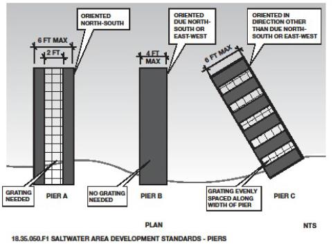
FIGURE 10 – FLOAT AND RAMP STANDARDS
G. Development Standards – Recreational Floats.
1. Single property owner recreational floats shall not exceed 64 square feet. Multiple property owner recreational floats shall not exceed 96 square feet.
2. The standards for private recreational floats are as follows:
a. Floats anchored offshore and used for residential recreational uses shall comply with the following standards:
(1) Applicants shall contact the Washington Department of Natural Resources to inquire on the need for an aquatic lease for locating recreational floats within State aquatic areas; and
(2) When feasible, floats shall be removed seasonally and placed in an appropriate unvegetated upland location.
3. Floats shall be located as close to shore as possible without interfering with natural beach processes or negatively affecting aquatic vegetation.
4. Floats shall not rest on the substrate at any time. Floats shall be located (anchored) at sufficient depth to maintain a minimum of one foot of draft between the float and the beach substrate at low tide.
5. Public recreational floats shall be the minimum size and dimensions necessary for the intended use, e.g., boat moorage, swimming area, public access.
6. Public and private recreational floats’ width shall comply with the following standards:
a. Floats with a width of six feet or less shall incorporate a minimum of 30 percent functional grating into the dock surface area;
b. Floats with a width greater than six feet or more shall incorporate a minimum of 50 percent functional grating into the dock surface area; and
c. Recreational floats shall be anchored utilizing either helical screw or “duckbill” anchor; anchor lines shall not rest on or disturb the substrate.
7. Recreational floats must be discernible under normal daylight conditions at a minimum of 100 yards and must have reflectors for nighttime visibility.
H. Shoreline Environment Regulations.
1. Marine Deepwater. Docks (piers, ramps and floats) and navigation buoys may be authorized subject to the provisions of this Shoreline Program. Moorage buoys are not allowed.
2. Natural. Docks (piers, ramps and floats) and buoys are not allowed.
3. Urban Conservancy. Docks (including piers, ramps and floats) and buoys may be authorized subject to the provisions of this Shoreline Program.
4. Shoreline Residential. Docks (piers, ramps and floats), buoys and recreational floats may be authorized subject to the provisions of this Shoreline Program.
5. Day Island Medium Intensity. Docks (piers, ramps and floats) and buoys may be authorized subject to the provisions of this Shoreline Program.
(Ord. 652 § 1 (Exh. A), 2015).
18.35.060 Restoration and enhancement.
Restoration is the reestablishment or upgrading of impaired ecological shoreline processes or functions. This may be accomplished through measures including, but not limited to, revegetation, removal of intrusive shoreline structures, and removal or treatment of toxic materials. Restoration does not imply a requirement for returning the shoreline area to aboriginal or pre-European settlement conditions.
Enhancement includes actions performed within an existing degraded shoreline, critical area and/or buffer to intentionally increase or augment one or more functions or values of the existing area. Enhancement actions include, but are not limited to, increasing plant diversity and cover, increasing wildlife habitat and structural complexity (snags, woody debris), installing environmentally compatible erosion controls, or removing nonindigenous plant or animal species.
Restoration and enhancement projects may include shoreline modification actions such as modification of vegetation, shoreline stabilization, dredging, and filling.
A. Policies.
1. Shoreline restoration and enhancement should be considered as an alternative to structural stabilization and protection measures where feasible.
2. All shoreline restoration and enhancement projects should protect the integrity of adjacent natural resources including aquatic habitats and water quality.
3. Restoration and enhancement projects should be designed, constructed, and maintained in keeping with restoration priorities and other policies and regulations set forth in UPMC 18.25.080.
4. Restoration and enhancement projects should be designed to minimize maintenance over time.
5. Fill associated with shoreline restoration and enhancement should not extend waterward more than necessary to achieve the intended results.
B. Regulations.
1. Shoreline restoration and enhancement may be authorized if the applicant demonstrates that no significant change to sediment transport will result and that the restoration or enhancement will not adversely affect shoreline ecological processes, water quality, properties, or habitat.
2. Shoreline restoration and enhancement projects shall use best available science and management practices. Restoration shall be carried out in accordance with the restoration framework principles and concepts contained within the City’s Restoration Plan and in accordance with the policies and regulations of this Shoreline Program.
3. Restoration and enhancement projects shall be designed to minimize maintenance over time.
4. Restoration and enhancement projects shall be designed, constructed, and maintained to avoid the use of shoreline stabilization measures. Where such measures cannot be avoided, bioengineering shall be used rather than bulkheads or other structural stabilization measures, unless it can be demonstrated that there are no feasible options to achieve the intended result. The primary purpose of restoration and enhancement projects including shoreline modification actions must clearly be restoration of the natural character and ecological functions of the shoreline. These projects must address legitimate restoration needs and priorities.
5. Fill for restoration and enhancement projects shall not extend waterward more than the minimum necessary to achieve the intended result and shall not result in the creation of additional upland area, to the extent feasible.
6. Restoration and enhancement projects shall not significantly interfere with the normal public use of the navigable waters of the State without appropriate mitigation.
7. Instream structures may be authorized only when necessary for a restoration or enhancement project, to improve fish passage, or for authorized road or utility crossings and subject to the following requirements:
a. Projects shall be evaluated for their potential adverse impacts upon the physical, hydrological, and biological characteristics as well as effects on instream/riparian habitat;
b. Instream structures and associated facilities shall be designed, constructed and maintained in a manner that will not degrade the quality of affected waters or instream/riparian habitat value, and minimizes adverse impacts to surrounding areas;
c. The location and design of instream structures shall give due consideration to the full range of public interests, watershed functions and processes, and environmental concerns, with special emphasis on protecting and restoring priority habitats and species;
d. Instream structures shall be designed based on an analysis of the reach or reaches to avoid the need for structural shoreline armoring; and
e. Instream structures and associated facilities shall provide for the protection and preservation of natural and cultural resources including, but not limited to, sensitive areas such as wetlands, waterfalls, erosion/accretion shore forms, and natural scenic vistas.
C. Shoreline Environment Regulations.
1. Restoration and enhancement projects that include shoreline modification actions may be authorized in all shoreline environments, provided:
a. The project’s primary purpose is the restoration of natural character and ecological functions of the shoreline; and
b. The project is consistent with the implementation of a comprehensive restoration plan approved by the City and/or Department of Ecology, or the Administrator finds that the project provides an ecological benefit and is consistent with this Shoreline Program.
(Ord. 652 § 1 (Exh. A), 2015).
18.35.070 Shoreline stabilization.
Shoreline stabilization includes actions taken to address erosion impacts to property, dwellings, businesses, or structures caused by natural processes such as current, flood, tides, wind, or wave action. These actions include structural and nonstructural methods.
Nonstructural methods include building setbacks, relocation of the structure to be protected, groundwater management, and planning and regulatory measures to avoid the need for structural stabilization.
Structural methods include “hard” and “soft” measures, defined as follows:
• Hard structural shoreline stabilization (also referred to as “hard” armoring) means erosion control measures using hardened structures that armor and stabilize the shoreline from further erosion. Examples of hard armoring include concrete, boulders, dimensional lumber or other materials to construct linear, vertical or near-vertical faces. These include bulkhead, rip-rap, groins, revetments, and similar structures.
• Soft structural shoreline stabilization (also referred to as “soft” armoring) means erosion control and restoration practices that rely on less rigid materials and may contribute to restoration, protection or enhancement of shoreline ecological functions. Examples of soft armoring include a mix of gravel, cobbles, boulders, logs and native vegetation placed to provide stability in a nonlinear, sloping arrangement.
Generally, the harder the construction measure the greater the impacts on shoreline processes and biological functions.
A. Policies.
1. Remaining unarmored shorelines should be preserved and the proliferation of bulkheads and other forms of shoreline armoring should be prevented.
2. New development requiring structural shoreline armoring should not be allowed. Shoreline use and development should be located and designed in a manner so that structural stabilization measures are not likely to become necessary in the future.
3. Structural shoreline armoring should only be authorized when there are no feasible alternatives, and when it can be demonstrated that it can be located, designed, and maintained in a manner that minimizes adverse impacts on shoreline ecology and system-wide processes, including effects on the project site, adjacent properties, and sediment transport.
4. The reconstruction or expansion of existing hard armoring should only be authorized where necessary to protect an existing primary structure and land supporting this structure that is in danger of loss or substantial damage, and where mitigation of impacts would not cause a net loss of shoreline ecological functions and processes.
5. The removal of bulkheads and other hard armoring and the restoration of the shoreline to a more natural condition should be encouraged. Where stabilization is necessary for the protection of private property, alternative measures that are less harmful to shoreline ecological functions should be employed.
6. Nonstructural stabilization measures, including relocating structures, increasing buffers, enhancing vegetation, and managing drainage and runoff are preferred over structural shoreline armoring.
7. Failing, harmful, unnecessary, or ineffective structures should be removed. Shoreline ecological functions and processes should be restored using nonstructural methods.
8. Shoreline stabilization and shoreline armoring for the purpose of leveling or extending property, or creating residential lawns, yards, or landscaping should not be allowed.
9. Shoreline stabilization measures, individually or cumulatively, should not result in a net loss of shoreline ecological functions or system-wide processes. Preference should be given to structural shoreline stabilization measures that have a lesser impact on ecological functions, and requiring mitigation of identified impacts resulting from said modifications.
10. The City should promote nonregulatory methods to protect, enhance, and restore shoreline ecological functions and other shoreline resources. Examples of such methods include public facility and resource planning, technical assistance, education, voluntary enhancement and restoration projects, land acquisition and restoration, and other incentive programs.
11. Publicly financed or subsidized shoreline erosion control measures should not restrict appropriate public access to the shoreline except where such access is determined to be infeasible because of incompatible uses, safety, security, or harm to ecological functions. Where feasible, ecological restoration and public access improvements should be incorporated into the project.
B. Regulations – New Development.
1. New shoreline use and development, including subdivision of land, shall be located and designed to eliminate the need for concurrent or future shoreline stabilization. If this is not feasible based upon a geotechnical analysis, soft structural protection measures shall be given preference over hard structural protection measures. The use of hard structural stabilization measures will only be allowed when it is demonstrated that soft structural measures are not feasible and that they will not result in significant impacts to adjacent or down-current properties.
2. Structural stabilization shall be located, designed, and constructed to minimize adverse impacts to shoreline ecological functions and processes. Protection of adjacent property and existing development shall also be considered in the design and location of structural stabilization measures.
3. Structural stabilization shall be located and designed in compliance with the vegetation conservation standards and critical area requirements in UPMC 18.25.100.
4. Structural shoreline stabilization measures to support new development will not be allowed unless all of the conditions below can be met:
a. The need to protect the development from damage due to erosion is demonstrated through a geotechnical report. For non-water-dependent development, including single-family residences, the damage must be caused by natural processes such as tidal action, currents, and waves;
b. The erosion is not being caused by upland conditions such as loss of vegetation and drainage;
c. Nonstructural measures such as placing the development further from the shoreline for non-water-dependent development, planting vegetation, or installing on-site drainage improvements are not feasible or sufficient;
d. The structure will not result in a net loss of shoreline ecological functions or processes;
e. Impacts to sediment transport will be avoided or minimized;
f. The structure will not cause adverse impacts to adjacent or down-current properties and shoreline areas; and
g. Publicly financed or subsidized shoreline erosion control measures will not restrict appropriate public access to the shoreline except where such access is determined to be infeasible because of incompatible uses, safety, security, or harm to ecological functions. Where feasible, ecological restoration and public access improvements will be incorporated into the project.
5. New development on steep slopes or bluffs shall be set back so that shoreline stabilization will not be needed for the life of the structure.
C. Regulations – New or Expanded Shoreline Stabilization Measures.
1. New or enlarged structural stabilization measures are not allowed except where necessary to protect or support existing or approved development, for human safety, for restoration or enhancement activities, or remediation of contaminated sites.
2. Structural shoreline armoring for the sole purpose of leveling or extending property or creating residential lawns, yards, or landscaping is not allowed. Where hard shoreline armoring already exists, property owners are encouraged to remove it and replace with soft armoring, or if conditions allow, return the shoreline to a natural condition.
3. New or enlarged structural shoreline stabilization measures for an existing, lawfully established development or primary structure are not allowed unless there is conclusive evidence, documented by a geotechnical analysis, that the structure is in danger from shoreline erosion caused by currents, waves, or tidal action. In addition, all of the following provisions shall apply:
a. Normal sloughing, erosion of steep bluffs, or shoreline erosion itself, without a scientific or geotechnical analysis, is not a demonstration of need; the geotechnical analysis shall evaluate on-site drainage issues and address drainage problems away from the shoreline edge before considering structural shoreline stabilization;
b. The design of the stabilization structure shall take into consideration erosion rates, on-site drainage issues, vegetation enhancement, and low-impact development measures as a means of reducing erosion;
c. The shoreline stabilization measures shall be designed, located, sized, and constructed to assure no net loss of ecological functions; and
d. In geologically hazardous areas, new stabilization structures are allowed only where no alternatives, including relocation or reconstruction of existing structures, are feasible, and less expensive than the proposed stabilization measure, and then only if no net loss of ecological functions will result.
4. The use of hard structural stabilization measures, such as bulkheads, is not allowed unless demonstrated in a geotechnical analysis that soft structural stabilization measures (vegetation) or nonstructural measures (increased setbacks) are not effective.
5. Where structural shoreline stabilization measures are necessary, the size of the stabilization structure shall be the minimum necessary. The Administrator may require that the size and design of the structure be modified to reduce impacts upon shoreline ecology.
6. Where hard armoring measures are necessary, materials shall be used in the order of priority listed in subsection (E)(7) of this section.
7. Where adverse impacts to shoreline ecological functions cannot be avoided, mitigation shall be required in accordance with mitigation sequencing priorities set forth in UPMC 18.25.070(C)(2).
8. In order to determine appropriate mitigation measures, the Administrator may require environmental information and analysis, including existing conditions, ecological functions and anticipated impacts, along with a vegetation management plan outlining how proposed mitigation measures would result in no net loss of shoreline ecological functions.
9. Shoreline stabilization measures that incorporate ecological restoration or enhancement through the placement of rocks, sand or gravel, and native shoreline vegetation are strongly encouraged. Soft shoreline stabilization that restores ecological functions may be authorized waterward of the ordinary high water mark.
10. Following completion of shoreline modification activities, disturbed areas shall be restored in accordance with vegetation conservation measures set forth in UPMC 18.25.100.
D. Regulations – Replacement and Repair.
1. For purposes of this section, “replacement” means the construction of a new structure to perform a shoreline stabilization function of an existing structure which no longer adequately serves its purpose. Additions to or increase in size of existing shoreline stabilization measures shall be considered new structures.
2. An existing shoreline stabilization structure may be replaced with a similar functioning structure if there is a demonstrated need to protect principal uses or structures from erosion caused by currents, tidal action, or waves. If a primary structure is located less than 25 feet from the ordinary high water mark, the property owner/applicant is not required to demonstrate need.
3. The replacement structure shall be designed, located, sized, and constructed to assure no net loss of shoreline ecological functions.
4. Replacement walls or bulkheads shall not encroach waterward of the ordinary high water mark or existing structure unless there are overriding safety or environmental concerns. In such cases, the replacement structure shall abut the existing shoreline stabilization structure. Where a net loss of ecological function associated with critical saltwater habitats would occur by leaving the existing structure, it shall be removed as part of the replacement measure.
5. Soft shoreline stabilization measures that provide restoration or shoreline ecological functions may be authorized waterward of the ordinary high water mark.
E. Design of Shoreline Stabilization Measures.
1. Shoreline stabilization measures shall be designed by a State-licensed engineer and shall conform to all applicable City and State policies and regulations, including the Washington State Department of Fish and Wildlife criteria governing the design of bulkheads.
2. The size of shoreline stabilization structures shall be the minimum necessary to protect the primary use or structure.
3. To protect their structural integrity, shoreline stabilization measures shall be designed, constructed, and maintained to allow drainage of surface or groundwater away from the structures.
4. Shoreline stabilization structures shall be located to tie in flush with existing bulkheads on adjacent properties, except when adjoining bulkheads do not comply with the standards set forth in the Shoreline Program.
5. Stairs may be built as an integral component of a bulkhead but shall not extend waterward of the bulkhead unless necessary to access the shoreline or an over-water use or structure that is authorized under the Shoreline Program.
6. Materials used for shoreline stabilization structures shall be durable, erosion-resistant, and not harmful to the environment. The following materials shall be prohibited: demolition debris, derelict vehicles, tires, concrete rubble, or any other materials that contain toxic substances or create visual blight along the shoreline.
7. Where hard armoring is approved, materials shall be used in the following order of priority:
a. Large stones, with vegetation planted in the gaps. Stone should not be stacked any steeper than a 2:1 slope;
b. Timbers or logs that have not been treated with toxic materials;
c. Stacked masonry block;
d. Pre-cast or cast-in-place reinforced concrete.
Other materials approved for use by the Department of Fish and Wildlife, Department of Ecology, or other agency with jurisdiction may be used in lieu of the materials in subsections (E)(7)(a) through (d) of this section.
8. Bioengineering is a preferred method of protecting upland property and structures or to maintain access to an authorized shoreline use.
9. Bioengineering shall be used when a geotechnical analysis confirms a need to prevent potential damage to a primary structure, but the need is not as immediate as within three years.
10. Bioengineering projects shall incorporate all of the following:
a. All bioengineering projects shall use a diverse variety of native plant materials, including trees, shrubs, and grasses, unless demonstrated infeasible for the particular site;
b. All cleared areas shall be replanted following construction and irrigated (if necessary) to ensure that all vegetation is fully reestablished within three years. Areas that fail to adequately reestablish vegetation shall be replanted with approved plant materials until such time as the plantings are viable;
c. The VCA setback established in Table 18.30.B shall be managed to allow bank protection plantings to become established for a minimum of three years. The setback shall exclude vehicles and activities that could disturb the site. Pedestrian access to the shoreline may be authorized in accordance with UPMC 18.25.100(D)(1)(b);
d. All bioengineering projects shall be monitored and maintained as necessary. Areas damaged by pests and/or the elements shall be promptly repaired; and
e. All construction and planting activities shall be scheduled to minimize impacts to water quality, fish and wildlife, aquatic and upland habitat, and to optimize survival of new vegetation.
F. Required Reports.
1. Geotechnical reports prepared pursuant to this section that address the need to prevent potential damage to a primary structure shall address the necessity for shoreline stabilization by estimating time frames and rates of erosion and report on the urgency associated with the specific situation. As a general matter, hard armoring solutions should not be authorized except when a report confirms that there is a significant possibility that such a structure will be damaged within three years as a result of shoreline erosion in the absence of such hard armoring measures, or where waiting until the need is immediate, would foreclose the opportunity to use measures that avoid impacts on ecological functions.
2. Where the geotechnical report confirms a need to prevent potential damage to a primary structure, but the need is not as immediate as the three years, the report may still be used to justify more immediate authorization to protect against erosion using soft armoring.
G. Shoreline Environment Regulations.
1. Hard structural shoreline stabilization may be authorized with a shoreline conditional use permit in the Day Island Medium Intensity, Shoreline Residential, and Urban Conservancy shoreline environments. Hard structural shoreline stabilization is not allowed in the Natural shoreline environment.
2. Soft shoreline structural stabilization may be authorized in the Day Island Medium Intensity, Shoreline Residential, Urban Conservancy and Natural shoreline environments subject to the provisions of this Shoreline Program.
3. Normal repair and maintenance of existing shoreline stabilization may be authorized in the Day Island Medium Intensity, Shoreline Residential, Urban Conservancy and Natural shoreline environments subject to the provisions of this Shoreline Program.
(Ord. 652 § 1 (Exh. A), 2015).
18.35.080 Breakwaters, jetties, groins and weirs.
A. Policies.
1. Jetties, breakwaters, groin systems or weirs should not be authorized unless no other practical alternative exists. If allowed, they should be located, designed, and maintained to avoid, then minimize, impacts to shoreline ecological functions and system-wide processes.
2. Existing private residential groins are critical structures for stabilizing shoreline areas at Sunset Beach and along the west side of Day Island. Maintenance and repair of these groins is supported in accordance with subsections (B) and (C) of this section.
B. Regulations – General.
1. Jetties and breakwaters are not allowed except as an integral component of a water- dependent use such as marina, and only when there is a documented need for the protection of navigation, water-dependent uses, public access, fisheries or habitat enhancement project, or a comprehensive beach management plan or other specific public purpose.
2. Where authorized, floating, portable, or submerged breakwater structures, or smaller discontinuous structures, shall be used only when it has been demonstrated that they will not impact shoreline ecology or processes such as littoral drift or cause erosion of down-drift beaches.
3. The location and design of breakwaters, jetties, groins, and weirs shall be subject to mitigation sequencing outlined in UPMC 18.25.070(C)(2).
4. The design of breakwaters, jetties, groins and weirs shall conform to all applicable requirements established by the Washington Department of Fish and Wildlife and the U.S. Army Corps of Engineers.
5. The design of breakwaters, jetties, groins and weirs shall be certified by a registered civil engineer.
6. Breakwaters, jetties, groins and weirs shall not intrude into critical salt water habitats, salmon and steelhead habitats, or critical areas unless the following conditions are met:
a. An alternative location or alignment is not feasible;
b. The project is designed to minimize its impacts on critical salt water habitats and the environment;
c. All adverse impacts will be mitigated;
d. The project, including any required mitigation, will result in no net loss of ecological functions associated with the critical salt water habitat;
e. The facility is in the public interest and consistent with the State’s interest in resource protection and species recovery; and
f. If the project results in significant unavoidable adverse impacts, the impacts are mitigated by creating in-kind replacement habitat near the project. Where in-kind replacement mitigation is not feasible, rehabilitating degraded habitat may be required as a substitute.
7. Breakwaters, jetties, groins and weirs shall be constructed of suitable materials. The use of solid waste, junk or abandoned automobiles, asphalt or any building demolition debris is not allowed.
8. The movement of sand and beach materials resulting from breakwaters, jetties, groins and weirs shall be evaluated as a part of the permit review. Those projects which are found to block littoral drift or cause new erosion of down-drift shoreline shall be required to establish and maintain an adequate long-term beach feeding program. This may include artificially transporting sand to the down-drift side of an inlet with jetties, or artificial beach feeding in the case of breakwaters, groins, and weirs.
9. Breakwaters, jetties, groins and weirs shall incorporate provisions for public access except where such structures are intended to protect existing single-family residences.
C. Regulations – Maintenance and Repair.
1. Maintenance and repair work shall comply with the general regulations provided in UPMC 18.35.080(B). An existing structure may be replaced with a similar structure if there is a demonstrated need to protect primary uses or structures from erosion caused by currents, tidal action, or waves. If a primary structure is located less than 25 feet from the ordinary high water mark, the property owner/applicant is not required to demonstrate there is a need for the maintenance or repair. For properties where the primary structure(s) are located more than 25 feet from the ordinary high water mark, the owner/applicant will need to demonstrate there is a need for the proposed maintenance or repair.
2. The replacement structure shall be designed, located, sized, and constructed to assure no net loss of shoreline ecological functions.
D. Shoreline Environment Regulations.
1. New breakwaters, jetties, groins and weirs are not allowed in the Natural shoreline environment designation.
2. New breakwaters, jetties, and weirs may be authorized in the Marine Deepwater, Urban Conservancy, Shoreline Residential, and Day Island Medium Intensity shoreline environments subject to a shoreline conditional use permit. New groins are allowed in the Marine Deepwater, Urban Conservancy, Shoreline Residential, and Day Island Medium Intensity shoreline environments only when necessary to support specific public purposes such as water-dependent uses, public access or public shoreline stabilization. New private groins are prohibited in all shoreline environments.
3. Maintenance and repair of existing breakwaters, jetties, groins and weirs may be authorized in the Marine Deepwater, Natural, Urban Conservancy, Shoreline Residential, and Day Island Medium Intensity shoreline environments subject to the provisions of this Shoreline Program.
(Ord. 652 § 1 (Exh. A), 2015).