


Chapter 19.55
OVERLAY ZONES
Sections:
19.55.020 Transition properties overlay zone standards.
19.55.030 Day Island/Day Island South Spit overlay zones.
19.55.040 Sunset Beach overlay zone.
19.55.060 Chambers Creek Properties overlay zone.
19.55.070 Public facilities overlay zone.
19.55.010 Purpose.
The purpose of overlay zones is to establish special standards for certain areas of the City characterized by unique historical development patterns or which may require special standards due to other unique circumstances applicable to the properties and to implement the goals and policies of the Comprehensive Plan regarding economic development and protection of residential neighborhoods.
(Ord. 741 § 1 (Exh. L), 2020; Ord. 688 § 1 (Exh. A), 2017; Ord. 607 § 1 (Exh. A), 2012; Ord. 443 § 1 (Exh. A), 2005; Ord. 394 § 1, 2003; Ord. 307 § 2, 2001).
19.55.020 Transition properties overlay zone standards.
A. Purpose. The purpose of the transition properties overlay zone standards is to provide extra protection for selected residential neighborhoods that abut or are across the street from commercial development.
B. Future development or redevelopment of non-single-family uses (attached or detached) of properties designated as transition properties shall be subject to the following standards:
1. There shall be a 25-foot minimum setback from all local streets;
2. Level I landscaping is required within the front yard setback abutting all local streets as defined in Chapter 13.20 UPMC, Article II, and in rear yard setbacks abutting R1 property. A landscape easement of the same width on abutting property may be used to satisfy this requirement;
3. Vehicle access shall not be permitted onto local streets unless provided specifically by ordinance;
4. A solid 100 percent sight-obscuring six-foot-high fence or wall shall be located within or along the required setback along all local streets. The location of the fence or wall shall be approved by the Director. For the purposes of this section, a cyclone fence with slats is not a sight-obscuring fence;
5. On-site lighting shall be shielded or directed away from abutting or adjacent residential uses;
6. Whenever a commercial building abuts the landscape requirement, or when the lower story of a commercial building is used for nonresidential purposes, only high (those that do not provide easy viewing) windows may be used on the side of the building abutting a residential use. This does not apply to residential uses.
(Ord. 741 § 1 (Exh. L), 2020; Ord. 607 § 1 (Exh. A), 2012; Ord. 443 § 1 (Exh. A), 2005; Ord. 423 § 70, 2004; Ord. 394 § 1, 2003; Ord. 307 § 2, 2001).
19.55.030 Day Island/Day Island South Spit overlay zones.
A. Purpose. The purpose of the Day Island/Day Island South Spit overlay zones is to preserve the unique residential character of Day Island and support continued marina operations at the north end of Day Island by allowing flexibility in building setbacks and other development standards.
B. Day Island Development Standards.
1. Unless otherwise specified in this section, all development standards of this code and UPMC Title 18, where applicable, also apply.
2. For the purpose of the Day Island development standards, Day Island is divided into two areas, Day Island and the South Spit. Day Island is generally that portion north of the 27th Street Bridge, and the South Spit generally that portion south of the 27th Street Bridge. Specific lots subject to the development standards are identified in Figure 1.
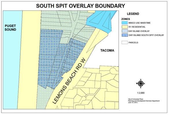
Figure 1
3. The following table specifies development standards for Day Island and Day Island South Spit areas.
|
Development Standards |
Day Island |
Day Island South Spit |
|---|---|---|
|
Front Yard Minimum Setback |
20 feet |
0 |
|
Side Yard Minimum Setback |
5 feet |
0 |
|
Rear Yard Minimum Setback (a) |
20/35 feet |
NA |
|
Garage Front Yard Setback (b) |
5 feet |
NA |
|
Accessory Structure Rear Yard Setback (c) |
5/35 feet |
NA |
|
Setback from OHWM (d) |
35 feet |
5 feet |
|
Building Setback from VCA (e) |
10 feet |
NA |
|
Principal Structure Maximum Height |
35 feet |
30 feet (f) |
|
Principal Structure Maximum Floor Area |
NA (g) |
1,600 square feet (h) |
Notes:
a. A 35-foot rear setback measured from the ordinary high water mark is required for properties located within shoreline jurisdiction. Otherwise a 20-foot setback measured from property line is required.
b. One single-story garage or carport not exceeding 15 feet in height from street centerline elevation is permitted in the front yard setback but no closer than five feet from the street providing the garage does not exceed a maximum width of 24 feet and size of 600 square feet.
c. Accessory structures may be constructed in the rear yard setback but no closer than 35 feet from the ordinary high water mark.
d. Ordinary High Water Mark. See UPMC 18.10.020 and 18.30.040, Table 18.30.B.
e. Vegetation Conservation Area. See UPMC 18.25.100.
f. From street centerline elevation.
g. Maximum floor area may be limited pursuant to UPMC 19.45.080, FAR standards.
h. Maximum floor area is exempt from UPMC 19.45.080, FAR standards.
C. Porches and Decks. The following porches and decks are allowed to project into the required setbacks as follows:
1. A porch or deck with a floor level no higher than the elevation of the floor of the house where the principal access door is located may project five feet into the front yard.
2. A porch or deck with a maximum floor level height of five feet above finished grade may project three feet into the side yard.
3. A porch or deck with a floor level no higher than the floor of the top story may project 15 feet into the rear yard but shall maintain a minimum 10-foot setback from any vegetation conservation area required under UPMC 18.25.100. Uncovered decks or patios with a walking surface no more than two feet above grade and consisting of pervious materials and designs may encroach into the required rear yard and vegetation conservation area to the extent permitted in UPMC 18.25.100(E)(3) when located within the Shoreline Residential shoreline environment.
D. Fences. Fences not to exceed four feet in height may be located in the required front yard setback. Fences not to exceed six feet in height may be located in the required side and rear yard setbacks. Fences located within the rear yard setback from OHWM shall comply with the requirements in UPMC 18.30.130(C)(9).
(Ord. 741 § 1 (Exh. L), 2020; Ord. 628 § 1 (Exh. A), 2013; Ord. 607 § 1 (Exh. A), 2012; Ord. 443 § 1 (Exh. A), 2005; Ord. 437 § 1, 2005; Ord. 423 § 71, 2004; Ord. 394 § 1, 2003; Ord. 307 § 2, 2001).
19.55.040 Sunset Beach overlay zone.
A. Purpose. The purpose of the Sunset Beach overlay zone is to recognize the building constraints associated with lots located between the shoreline and railroad right-of-way and to preserve the unique residential character of Sunset Beach by allowing flexibility in building setbacks and other development standards.
B. Sunset Beach Development Standards.
1. Unless otherwise specified in this section, all development standards of this code and UPMC Title 18, where applicable, also apply.
2. The following table specifies development standards for Sunset Beach:
|
Sunset Beach Development Standards |
|
|---|---|
|
Front Yard Minimum Setback (a) |
0/20 feet |
|
Side Yard Minimum Setback (b) |
0 – 5 feet |
|
Rear Yard Minimum Setback from OHWM (c) |
5 feet |
|
Principal Structure Maximum Height |
35 feet |
|
Principal Structure Maximum Floor Area |
NA (d) |
Notes:
a. A zero-foot front yard setback measured from the railroad right-of-way shall be allowed until additional right-of-way is purchased from the railroad at which time a setback equal to the distance between the front of the house and the edge of the railroad right-of-way or 20 feet, whichever is less, shall be required.
b. A minimum side yard setback of zero is permitted. The two side yards combined must total at least five feet.
c. Rear yard is measured from the ordinary high water mark – see UPMC 18.10.020 and 18.30.040, Table 18.30.B.
d. Maximum floor area is exempt from UPMC 19.45.080, FAR standards.
C. Porches and Decks. A covered deck or porch may be constructed in a required side yard providing emergency access is available from the front to the rear of the house or structure.
D. Fences. Fences not to exceed six feet in height may be located in the required front and side yard setbacks. Fences located within the rear yard setback from OHWM shall comply with the requirements in UPMC 18.30.130(C)(9).
(Ord. 741 § 1 (Exh. L), 2020; Ord. 628 § 1 (Exh. A), 2013; Ord. 607 § 1 (Exh. A), 2012; Ord. 443 § 1 (Exh. A), 2005; Ord. 394 § 1, 2003; Ord. 307 § 2, 2001).
19.55.050 Town Center overlay.
Repealed by Ord. 662.
(Ord. 607 § 1 (Exh. A), 2012; Ord. 605 § 1 (Exh. A), 2011; Ord. 549 § 1 (Exh. A), 2009; Ord. 443 § 1 (Exh. A), 2005; Ord. 409 § 8, 2004; Ord. 394 § 1, 2003).
Code reviser’s note: The Town Center overlay design standards were amended by Ordinances 549 and 605. No change was made to the code.
19.55.060 Chambers Creek Properties overlay zone.
A. Purpose. The purpose of the Chambers Creek Properties overlay zone (CCPO) is to promote the development of the Chambers Creek Properties master site plan. The overlay will allow the City and County to manage the development of the Chambers Creek Properties in a way that is most beneficial to the County and community.
B. Standards. The City has adopted the Chambers Creek Properties master site plan, joint procedural agreement and the Chambers Creek Properties design standards in this title to implement the master site plan. These documents are hereby incorporated by reference. Portions of the Chambers Creek Properties overlay located within the City’s shoreline jurisdiction shall be subject to the Shoreline Master Program requirements in UPMC Title 18.
C. Use. The following uses shall be permitted in the Chambers Creek Properties overlay:
1. Uses and uses commonly accessory to those uses identified in the Chambers Creek Properties master site plan shall be permitted within the overlay zone subject to the Chambers Creek joint procedural agreement and the Chambers Creek Properties design standards.
2. Essential public facilities, existing on January 1, 2005, located outside the master site plan area and permitted in accordance with Chapter 19.40 UPMC.
3. Administrative government offices.
4. Level 1 public maintenance facilities outside the master site plan area.
5. Level 2 public maintenance facilities outside the master site plan area subject to a conditional use permit.
6. Uses and activities described in the Chambers Creek Properties master site plan that are not listed as exemptions in the joint procedural agreement may occur without the requirement to obtain a land use permit (e.g., nonconforming use permit, conditional use permit, or special use permit); however, the requirements for building permits, land development permits, and environmental permits still apply. Uses and activities specifically exempted under the joint procedural agreement will continue to occur within the CCPO and may require modification of existing permits and approvals and/or issuance of new permits and approvals subject to the UPMC.
D. Scope of CCPO. The total acreage subject to the master site plan and CCPO provisions in this title may be increased upon submittal by the County of a formal written notice describing additional, contiguous properties acquired and approval by the City.
(Ord. 741 § 1 (Exh. L), 2020; Ord. 688 § 1 (Exh. A), 2017; Ord. 636 § 2 (Exh. A), 2014; Ord. 628 § 1 (Exh. A), 2013; Ord. 607 § 1 (Exh. A), 2012; Ord. 443 § 1 (Exh. A), 2005; Ord. 394 § 1, 2003; Ord. 383 § 1, 2003).
19.55.070 Public facilities overlay zone.
A. Purpose. The purpose of the public facilities overlay zone is to ensure the impacts associated with public facilities are appropriately mitigated and to provide exceptions to allow public facilities to best serve their clients and community with less cost to the taxpayer.
B. Standards. Unless otherwise specified, all uses and standards of the underlying zone apply.
C. Use. The following land uses shall be permitted in the public facilities overlay:
1. Uses Permitted Outright.
a. Education Level 1.
b. Public maintenance facilities (established prior to July 1, 2012).
c. Public safety services (established prior to July 1, 2012).
d. Transportation Levels 1 and 2 (established prior to July 1, 2012).
2. Uses Permitted by Conditional Use Permit.
a. Public maintenance facilities.
b. Public safety services.
c. Public school auxiliary services.
d. Transportation Levels 1 and 2.
D. Signs. Gateway and changing message signs are permitted subject to design and construction standards, general and specific sign requirements, and other requirements of Chapter 19.75 UPMC, notwithstanding any restrictions otherwise prohibiting such signs. For the purposes of this provision, “gateway sign” shall have the same definition as “City gateway sign.” The following restrictions apply to gateway and changing message signs in the public facilities overlay zone:
1. Gateway signs existing as of the effective date of this provision may be maintained or reconstructed. No additional gateway signs are permitted.
2. Changing message signs shall be programmed so that the transmission of changing messages is limited to 5:30 a.m. to 6:30 p.m. during standard time and 5:30 a.m. to 8:30 p.m. during daylight saving time, except when the transmission of emergency messages is determined to be in the public interest.
3. Changing messages shall be limited to text. Messages that include graphics, animation, video clips or other non-text images are prohibited.
4. Changing message signs shall be limited in area to 12 square feet. A changing message sign may be incorporated into an identification sign that includes additional area devoted to static (non-changing) messages.
5. Changing message signs shall be programmed to adjust illumination levels to reflect ambient light levels and ensure that illumination levels will not create excessive glare that may result in traffic hazards or other public nuisance.
(Ord. 741 § 1 (Exh. L), 2020; Ord. 688 § 1 (Exh. A), 2017; Ord. 610 § 1 (Exh. A), 2012; Ord. 607 § 1 (Exh. A), 2012; Ord. 548 § 1 (Exh. A), 2009; Ord. 443 § 1 (Exh. A), 2005; Ord. 394 § 1, 2003).
19.55.080 Mixed use district incentive overlay zone.
Repealed by Ord. 741.
(Ord. 688 § 1 (Exh. A), 2017; Ord. 607 § 1 (Exh. A), 2012; Ord. 443 § 1 (Exh. A), 2005; Ord. 422 § 3, 2004).