


Chapter 21.04
CRITICAL AREAS
Sections:
21.04.030 Jurisdiction – Critical areas.
21.04.040 Best available science.
21.04.045 Administrative procedures.
21.04.055 Administrative rules.
21.04.075 Relationship to other regulations.
21.04.080 Multiple designations.
21.04.095 Critical area reports – General requirements.
21.04.100 Critical area reports – Modifications to requirements.
21.04.105 Mitigation requirements.
21.04.110 Mitigation sequencing.
21.04.115 Mitigation plan requirements.
21.04.120 Bonds to ensure mitigation, maintenance and monitoring.
21.04.135 Critical area inspections.
21.04.140 Unauthorized critical area alterations and enforcement.
21.04.200 Critical aquifer recharge areas – Designation.
21.04.210 Mapping of critical aquifer recharge areas.
21.04.220 Activities allowed in critical aquifer recharge areas.
21.04.230 Critical area report – Additional requirements for critical aquifer recharge areas.
21.04.240 Performance standards – General requirements.
21.04.250 Performance standards – Specific uses.
21.04.260 Uses prohibited in critical aquifer recharge areas.
21.04.300 Wetlands critical areas – Designation.
21.04.310 Mapping of wetland areas.
21.04.320 Critical area report – Additional requirements for wetland areas.
21.04.330 Activities allowed in wetlands.
21.04.340 Performance standards – General requirements.
21.04.341 Signs and fencing of wetlands.
21.04.342 Performance standards – Wetland buffer averaging.
21.04.343 Performance standards – Wetland buffer increase.
21.04.344 Performance standards – Wetland buffer decrease.
21.04.345 Performance standards – Buffer management plan.
21.04.346 Performance standards – Specific activities and uses.
21.04.347 Performance standards – Mitigation requirements.
21.04.348 Performance standards – Wetland mitigation plan.
21.04.350 Wetland mitigation banks.
21.04.400 Mapping of frequently flooded areas.
21.04.500 Geologically hazardous areas – Designation.
21.04.510 Mapping of geologically hazardous areas.
21.04.520 Activities allowed in geologically hazardous areas.
21.04.530 Critical area report – Additional requirements for geologically hazardous areas.
21.04.540 Critical area report – Additional requirements for specific geologically hazardous areas.
21.04.550 Performance standards – General requirements.
21.04.560 Performance standards – Specific hazards.
21.04.600 Fish and wildlife habitat conservation areas – Designation.
21.04.610 Fish and wildlife habitat conservation areas – Mapping.
21.04.620 Fish and wildlife habitat conservation areas – Water bodies – Allowed uses.
21.04.630 Critical area report – Additional requirements for habitat conservation areas.
21.04.640 Performance standards – General requirements.
21.04.650 Performance standards – Specific habitats.
21.04.660 Performance standards – Subdivisions.
21.04.670 Fish and wildlife habitat conservation areas – Piped streams.
21.04.671 Fish and wildlife habitat conservation areas – Mitigation standards.
21.04.700 Landfill vicinity development standards.
21.04.005 Purpose.
A. The purpose of this chapter is to designate and classify ecologically sensitive and hazardous areas and to protect these areas and their functions and values, while also allowing for reasonable use of private property.
B. This chapter is to implement the goals, policies, guidelines, and requirements of the city of Walla Walla (“city”) urban area comprehensive plan and the Growth Management Act.
C. The city finds that critical areas provide a variety of valuable and beneficial biological and physical functions that benefit the city and its residents, and/or may pose a threat to human safety or to public and private property. The beneficial functions and values provided by critical areas include, but are not limited to, water quality protection and enhancement, fish and wildlife habitat, food chain support, flood storage, conveyance and attenuation of flood waters, ground water recharge and discharge, erosion control, wave attenuation, protection from hazards, historical, archaeological, and aesthetic value protection, and recreation. These beneficial functions are not listed in order of priority.
D. Goals. By limiting development and alteration of critical areas, this chapter seeks to:
1. Protect members of the public and public resources and facilities from injury, loss of life, or property damage due to landslides and steep slope failures, erosion, seismic events, abandoned mines, or flooding;
2. Maintain healthy, functioning ecosystems through the protection of unique, fragile, and valuable elements of the environment, including ground and surface waters, wetlands, and fish and wildlife and their habitats, and to conserve the biodiversity of plant and animal species;
3. Direct activities not dependent on critical areas resources to less ecologically sensitive sites and mitigate unavoidable impacts to critical areas by regulating alterations in and adjacent to critical areas; and
4. Prevent cumulative adverse environmental impacts to water quality, wetlands, and fish and wildlife habitat, and the overall net loss of wetlands, frequently flooded areas, and habitat conservation areas.
E. The regulations of this chapter are intended to protect critical areas in accordance with the Growth Management Act and through the application of the best available science, as determined according to WAC 365-195-900 through 365-195-925, and in consultation with state and federal agencies and other qualified professionals.
F. This chapter is to be administered with flexibility and attention to site-specific characteristics. It is not the intent of this chapter to make a parcel of property unusable by denying its owner reasonable economic use of the property or to prevent the provision of public facilities and services necessary to support existing and planned development.
G. The city’s enactment or enforcement of this chapter shall not be construed for the benefit of any individual person or group of persons other than the general public. (Ord. 2009-07 § 1 (part), 2009).
21.04.010 Authority.
A. As provided herein, the development services director (“director”) is given the authority to interpret and apply, and the responsibility to enforce, this chapter to accomplish the stated purpose.
B. The city may withhold, condition, or deny development permits or activity approvals to ensure that the proposed action is consistent with this chapter. (Ord. 2009-07 § 1 (part), 2009).
21.04.015 Applicability.
A. The provisions of this chapter shall apply to all lands, all land uses and development activity, and all structures and facilities in the city, outside of shoreline jurisdiction, whether or not a permit or authorization is required, and shall apply to every person, firm, partnership, corporation, group, governmental agency, or other entity that owns, leases, or administers land within the city. No person, company, agency, or applicant shall alter a critical area or buffer except as consistent with the purposes and requirements of this chapter. It does not apply to lawful uses or legal nonconforming uses existing at the time of adoption. Agricultural uses or changes from one agricultural use to another are exempt from this chapter. The provisions of this chapter shall not impinge upon water rights.
B. Critical areas within the city’s shoreline jurisdiction are subject to the critical areas regulations found in the City of Walla Walla Shoreline Master Program, Appendix A – Critical Areas in Shoreline Jurisdiction.
C. The city shall not approve any permit or otherwise issue any authorization to alter the condition of any land, water, or vegetation, or to construct or alter any structure or improvement in, over, or on a critical area or associated buffer, without first ensuring compliance with the requirements of this chapter including but not limited to the following:
1. Building permit;
2. Conditional use permit;
3. Clearing and grading permit;
4. Short subdivision;
5. Subdivision;
6. Planned unit development;
7. Boundary line adjustment;
8. Binding site plan; or
9. Any other adopted permit or required approval not expressly exempted by this chapter.
Figure 1 identifies how critical areas review is incorporated into the application process for the underlying permit.
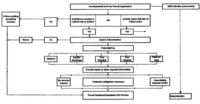
Figure 1
D. Approval or denial of a permit or development proposal pursuant to the provisions of this chapter does not discharge the obligation of the applicant to comply with the provisions of this chapter. (Ord. 2018-16 § 10, 2018: Ord. 2009-07 § 1 (part), 2009).
21.04.020 Definitions.
Words not defined in this chapter shall be as defined in the Walla Walla Municipal Code, the Washington Administrative Code, or the Revised Code of Washington. Words not found in either code shall be as defined in the Webster’s Third New International Dictionary, latest edition.
“Adaptive management” relies on scientific methods to evaluate how well regulatory and nonregulatory actions protect the critical area. An “adaptive management program” is a formal and deliberate scientific approach to taking action and obtaining information in the face of uncertainty.
“Adjacent” means immediately adjoining (in contact with the boundary of the influence area) or within a distance that is less than that needed to separate activities from critical areas to ensure protection of the functions and values of the critical areas. “Adjacent” shall mean any activity or development located:
1. On a site immediately adjoining a critical area;
2. A distance equal to or less than the required critical area buffer width and building setback;
3. A distance equal to or less than two hundred feet upland from a stream, wetland, or water body;
4. Bordering or within the floodway, floodplain or channel migration zone; or
5. A distance equal to or less than two hundred feet from a critical aquifer recharge area.
“Agricultural land” means land primarily devoted to the commercial production of horticultural, viticultural, floricultural, dairy, apiary, or animal products or of berries, grain, hay, straw, turf, seed, Christmas trees not subject to the excise tax imposed by RCW 84.33.100 through 84.33.140, or livestock, and/or that has been designated as having long-term commercial significance for agricultural production.
“Agricultural uses” means agricultural activities including farming, horticulture, silviculture, irrigation delivery systems, drainage systems, ranching and grazing of animals and pest and weed control. This includes agricultural set-aside land, lands lying idle under government programs and changes between agricultural activities.
“Alteration” means any human-induced change in an existing condition of a critical area or its buffer. Alterations include but are not limited to grading, filling, channelizing, dredging, clearing (vegetation), construction, compaction, excavation or any other activity that changes the character of the critical area.
“Applicant” means a person who files an application for permit under this chapter and who is either the owner of the land on which that proposed activity would be located, a contract purchaser, or the authorized agent of such a person.
“Aquifer” means a geological formation, group of formations or part of a formation that is capable of yielding a significant amount of water to a well or spring.
“Aquifer, confined” means an aquifer bounded above and below by beds of distinctly lower permeability than that of the aquifer itself and that contains ground water under sufficient pressure for the water to rise above the top of the aquifer.
“Aquifer recharge areas” means areas that, due to the presence of certain soils, geology, and surface water, act to recharge ground water by percolation.
“Aquifer, sole source” means an area designated by the U.S. Environmental Protection Agency under the Safe Drinking Water Act of 1974, Section 1424(e). The aquifer(s) must supply fifty percent or more of the drinking water for an area without a sufficient replacement available.
“Aquifer susceptibility” means the ease with which contaminants can move from the land surface to the aquifer based solely on the types of surface and subsurface materials in the area. Susceptibility usually defines the rate at which a contaminant will reach an aquifer unimpeded by chemical interactions with the vadose zone media.
“Aquifer, unconfined” means an aquifer not bounded above by a bed of distinctly lower permeability than that of the aquifer itself and containing ground water under pressure approximately equal to that of the atmosphere. This term is synonymous with the term “water table aquifer.”
“Best available science” means current scientific information used in the process to designate, protect, or restore critical areas that is derived from a valid scientific process as defined by WAC 365-195-900 through 365-195-925. Sources of best available science are included in “Citations of Recommended Sources of Best Available Science for Designating and Protecting Critical Areas” published by the state Office of Community Development.
“Best management practices (BMPs)” means conservation practices or systems of practices and management measures that:
1. Control soil loss and reduce water quality degradation caused by high concentrations of nutrients, animal waste, toxics, and sediment;
2. Minimize adverse impacts to surface water and ground water flow, circulation patterns, and to the chemical, physical, and biological characteristics of wetlands;
3. Protect trees and vegetation designated to be retained during and following site construction;
4. Provide standards for proper use of chemical herbicides within critical areas; and
5. Prevent or reduce the release of pollutants and other adverse impacts to the waters of Washington State.
“Biodiversity” means the variety of animal and plant life and its ecological processes and interconnections, represented by the richness of ecological systems and the life that depends on them, including human life and economies.
“Buffer” or “buffer zone” means an area contiguous to and protecting a critical habitat that is required for the continued maintenance, functioning, and/or structural stability of a critical area.
“Building setback” means the distance between the critical area buffer and a vertical building wall, intended to provide adequate room for construction, use, maintenance activities and access without infringing upon the critical area or required buffer.
“Compensation project” means actions necessary to replace project-induced critical area and buffer losses, including land acquisition, planning, construction plans, monitoring and contingency actions.
“Compensatory mitigation” means replacing project-induced critical wetland habitat losses or impacts, and includes, but is not limited to, the following:
1. Restoration. Actions performed to reestablish wetland functional characteristics and processes that have been lost by alterations, activities, or catastrophic events within an area that no longer meets the definition of a wetland.
2. Creation. Actions performed to intentionally establish a wetland at a site where it did not formerly exist.
3. Enhancement. Actions performed to improve the condition of existing degraded wetlands so that the functions they provide are of a higher quality.
4. Preservation. Actions taken to ensure the permanent protection of existing, high-quality wetlands.
“Conservation easement” means a legal agreement that the property owner enters into to restrict uses of the land. Such restrictions can include, but are not limited to, passive recreation uses such as trails or scientific uses and fences or other barriers to protect habitat. The easement is recorded on a property deed, runs with the land, and is legally binding on all present and future owners of the property, therefore providing permanent or long-term protection.
“Critical aquifer recharge areas” means areas designated by WAC 365-190-080(2) that are determined to have a critical recharging effect on aquifers used for potable water as defined by WAC 365-190-030(2).
“Critical areas” include any of the following areas or ecosystems: aquifer recharge areas, fish and wildlife habitat conservation areas, frequently flooded areas, geologically hazardous areas, and wetlands, as defined in Chapter 36.70A RCW and this chapter.
“Critical facility” means a facility for which even a slight chance of flooding, inundation, or impact from a hazard event might be too great. Critical facilities include, but are not limited to, schools, nursing homes, hospitals, police, fire and emergency response installations, and installations that produce, use or store hazardous materials or hazardous waste.
“Critical species” means all animal and plant species listed by the state or federal government as threatened or endangered.
“Cumulative impacts or effects” means the combined, incremental effects of human activity on ecological or critical areas functions and values. Cumulative impacts result when the effects of an action are added to or interact with other effects in a particular place and within a particular time. It is the combination of these effects, and any resulting environmental degradation, that should be the focus of cumulative impact analysis and changes to policies and permitting decisions.
“Developable area” means a site or portion of a site that may be utilized as the location of development, in accordance with the rules of this chapter.
“Development” means any activity upon the land consisting of construction or alteration of structures, earth movement, dredging, dumping, grading, filling, mining, removal of any sand, gravel, or minerals, driving of piles, drilling operations, bulkheading, clearing of vegetation, or other land disturbance. Development includes the storage or use of equipment or materials inconsistent with the existing use. Development also includes approvals issued by the city of Walla Walla that bind land to specific patterns of use, including but not limited to subdivisions, short subdivisions, conditional use permits, and binding site plans. Development activity does not include the following activities:
1. Interior building improvements.
2. Exterior structure maintenance activities, including painting and roofing.
3. Routine landscape maintenance of established, ornamental landscaping, such as lawn mowing, pruning and weeding.
4. Maintenance of the following existing facilities that does not expand the affected area: septic tanks (routine cleaning); wells; individual utility service connections; and individual cemetery plots in established and approved cemeteries.
“Development permit” means any permit issued by the city of Walla Walla, or other authorized agency, for construction, land use, or the alteration of land.
“Development services department” (known and referred to alternatively herein as the “city development services department,” “department,” or “staff”) means the department or such other person(s) to whom the city manager assigns the primary responsibility of administering and enforcing this code.
“Director” means the director of the development services department or such other person to whom the city manager assigns the primary responsibility of administering and enforcing this code, and such other staff granted authority to act on behalf of the director or other assigned person.
“Eco-connectivity” is a physical feature of the land as well as functional one. It is the geophysical connection between natural habitat areas that allows fish and animals to move between feeding, reproductive, rearing, and resting areas. The functional connection is dependent on the physical connection.
“EDT priority protection reach” means reach designated as a priority using the ecosystem diagnosis and treatment method.
“Elevated building” means a building that has no basement and whose lowest elevated floor is raised above ground level by foundation walls, shear walls, posts, piers, pilings, or columns.
“Emergent wetland” means a wetland with at least thirty percent of the surface area covered by erect, rooted, herbaceous vegetation extending above the water surface as the uppermost vegetative strata.
“Erosion” means the process whereby wind, rain, water, and other natural agents mobilize and transport particles.
“Erosion hazard areas” means at least those areas identified by the United States Department of Agriculture National Resources Conservation Service as having a severe rill and inter-rill erosion hazard.
“Exotic” means any species of plants or animals which are foreign to the planning area (not listed on the state plant list).
“Extreme slope hazard areas” means those areas with predevelopment slope greater than forty-five percent.
“Fish and wildlife habitat conservation areas” means areas that serve a critical role in sustaining needed habitats and species for the functional integrity of the ecosystem, and which, if altered, may reduce the likelihood that the species will persist over the long term. These areas may include, but are not limited to, rare or vulnerable ecological systems, communities, and habitat or habitat elements including seasonal ranges, breeding habitat, winter range, and movement corridors; and areas with high relative population density or species richness. “Fish and wildlife habitat conservation areas” does not include such artificial features or constructs as irrigation delivery systems, irrigation infrastructure, irrigation canals, or drainage ditches that lie within the boundaries of, and are maintained by, a port district or an irrigation district or company (WAC 365-190-030(6)). These areas are guided by the state’s priority habitats and species list and include the following:
1. Areas with which state or federally designated endangered, threatened, and sensitive species have a primary association;
2. Habitats of local importance, including but not limited to areas designated as priority habitat by the Department of Fish and Wildlife, areas that provide important habitat for neotropical migratory songbirds, areas that provide important habitat for wintering birds of prey, and areas that provide unique habitats within the city;
3. Naturally occurring ponds under twenty acres and their submerged aquatic beds that provide fish or wildlife habitat, including those artificial ponds intentionally created from dry areas in order to mitigate impacts to ponds;
4. Waters of the state, including lakes, rivers, ponds, streams, inland waters, underground waters, salt waters and all other surface waters and watercourses within the jurisdiction of the state of Washington;
5. Lakes, ponds, streams, and rivers planted with game fish by a governmental or tribal entity;
6. State natural area preserves and natural resource conservation areas; and
7. Land essential for preserving connections between habitat blocks and open spaces.
“Fish habitat” means habitat that is used by fish at any life stage at any time of the year, including potential habitat likely to be used by fish that could be recovered by restoration or management, and includes off-channel habitat.
“Forested wetland” means a wetland with at least thirty percent of the surface area covered by woody vegetation greater than twenty feet in height that is at least partially rooted within the wetland.
“Formation” means an assemblage of earth materials grouped together into a unit that is convenient for description or mapping.
“Formation, confining” means the relatively impermeable formation immediately overlying a confined aquifer.
“Functions and values” means the beneficial roles served by critical areas including, but not limited to, water quality protection and enhancement, fish and wildlife habitat, food chain support, flood storage, conveyance and attenuation, ground water recharge and discharge, erosion control, wave attenuation, protection from hazards, historical and archaeological and aesthetic value protection, and recreation. These beneficial roles are not listed in order of priority.
“Geologically hazardous areas” means areas that may not be suited to development consistent with public health, safety or environmental standards because of their susceptibility to erosion, sliding, earthquake, or other geological events as designated by WAC 365-190-030(9). Types of geologically hazardous areas include: erosion, landslide, seismic, mine, and volcanic hazards.
“Ground water” means water in a saturated zone or stratum beneath the surface of land or a surface water body.
“Ground water management area” means a specific geographic area or subarea designated pursuant to Chapter 173-100 WAC for which a ground water management program is required.
“Ground water management program” means a comprehensive program designed to protect ground water quality, to ensure ground water quantity, and to provide for efficient management of water resources while recognizing existing ground water rights and meeting future needs consistent with local and state objectives, policies, and authorities within a designated ground water management area or subarea and developed pursuant to Chapter 173-100 WAC.
“Growth Management Act” means Chapters 36.70A and 36.70B RCW, as amended.
“Habitat” means the physical and biological environment on which a given species depends for its survival; the place or type of site where a plant, organism or animal population naturally occurs.
“Habitat conservation areas” means areas designated as fish and wildlife habitat conservation areas.
“Habitat, wildlife” means the aquatic and terrestrial environments required for wildlife to complete their life cycles, including air, food, cover, water and spatial requirements.
Habitats of Local Importance. These areas include a seasonal range or habitat element with which a given species has a primary association and which, if altered, may reduce the likelihood that the species will maintain and reproduce over the long term. These might include areas of high relative density or species richness, breeding habitat, winter range, and movement corridors. These might also include habitats that are of limited availability or high vulnerability to alterations, such as cliffs, talus, and wetlands. (WAC 365-190-030.)
“Hazard areas” means areas designated as frequently flooded areas or geologically hazardous areas due to potential for erosion, landslide, seismic activity, extreme slopes, or other geological condition.
“Hazardous substances” means any liquid, solid, gas, or sludge, including any material, substance, product, commodity, or waste, regardless of quantity, that exhibits any of the physical, chemical or biological properties described in WAC 173-303-090 or 173-303-100.
“High quality wetlands” means those wetlands that meet the following criteria:
1. No, or isolated, human alteration of the wetland topography;
2. No human-caused alteration of the hydrology, or the wetland appears to have recovered from the alteration;
3. Low cover and frequency of exotic plant species;
4. Relatively little human-related disturbance of the native vegetation, or recovery from past disturbance;
5. If the wetland system is degraded, it still contains a viable and high quality example of a native wetland community; and
6. No known major water quality problems.
“Historic condition” means the condition of the land, including flora, fauna, soil, topography, and hydrology, that existed before the area and vicinity were developed or altered by human activity.
“Hydraulic project approval (HPA)” means a permit issued by the state Department of Fish and Wildlife for projects that affect the bed or flow of waters of the state in accordance with Chapter 77.55 RCW and Chapter 220-110 WAC.
“Hydric soil” means a soil that is saturated, flooded or ponded long enough during the growing season to develop anaerobic conditions in the upper part. The presence of hydric soil shall be determined following the methods described in the Washington State Wetland Identification and Delineation Manual, as amended.
“Hydrologic soil groups” means soils grouped according to their runoff-producing characteristics under similar storm and cover conditions. Properties that influence runoff potential are depth to seasonally high water table, intake rate and permeability after prolonged wetting, and depth to a low permeable layer. Hydrologic soil groups are normally used in equations that estimate runoff from rainfall, but can be used to estimate a rate of water transmission in soil. There are four hydrologic soil groups:
1. Low runoff potential and a high rate of infiltration potential;
2. Moderate infiltration potential and a moderate rate of runoff potential;
3. Slow infiltration potential and a moderate to high rate of runoff potential; and
4. High runoff potential and very slow infiltration and water transmission rates.
“Hydrophytic vegetation” means macrophytic plant life growing in water or on a substrate that is at least periodically deficient in oxygen as a result of excessive water content. The presence of hydrophytic vegetation shall be determined following the methods described in the Washington State Wetland Identification and Delineation Manual, as amended.
“Hyporheic zone” means the saturated zone located beneath and adjacent to streams that contains some portion of surface waters, serves as a filter for nutrients, and maintains water quality.
“Impervious surface” means a hard surface area that either prevents or retards the entry of water into the soil mantle as under natural conditions prior to development or that causes water to run off the surface in greater quantities or at an increased rate of flow from the flow present under natural conditions prior to development. Common impervious surfaces include, but are not limited to, rooftops, walkways, patios, driveways, parking lots or storage areas, concrete or asphalt paving, gravel roads, packed earthen materials, and oiled macadam or other surfaces which similarly impede the natural infiltration of stormwater.
“Infiltration” means the downward movement of water from the land surface to the subsoil.
Injection Well(s).
1. Class I. A well used to inject industrial, commercial, or municipal waste fluids beneath the lowermost formation containing, within one-quarter mile of the well bore, an underground source of drinking water.
2. Class II. A well used to inject fluids:
a. Brought to the surface in connection with conventional oil or natural gas exploration or production and that may be commingled with wastewaters from gas plants that are an integral part of production operations, unless those waters are classified as dangerous wastes at the time of injection;
b. For enhanced recovery of oil or natural gas; or
c. For storage of hydrocarbons that are liquid at standard temperature and pressure.
3. Class III. A well used for extraction of minerals, including but not limited to the injection of fluids for:
a. In-situ production of uranium or other metals that have not been conventionally mined;
b. Mining of sulfur by Frasch process; or
c. Solution mining of salts or potash.
4. Class IV. A well used to inject dangerous or radioactive waste fluids.
5. Class V. All injection wells not included in Classes I, II, III, or IV.
“In-kind compensation” means the same species, habitat type, and function impacted. If the impacted habitat is disturbed, it means replacement with the natural habitat that would occur. It does not mean replacement in category.
“Inter-rill” means areas subject to sheetwash.
“Isolated wetlands” means those wetlands that are outside of and not contiguous to any one-hundred-year floodplain of a lake, river, or stream, and have no contiguous hydric soil or hydrophytic vegetation between the wetland and any surface water.
“Joint aquatic resource permits application (JARPA)” means a single application form that may be used to apply for hydraulic project approvals, shoreline management permits, approvals of exceedance of water quality standards, water quality certifications, Coast Guard bridge permits, Department of Natural Resources use authorization, and Army Corps of Engineers permits.
“Landslide hazard areas” means areas that are potentially subject to risk of mass movement due to a combination of geologic landslide resulting from a combination of geologic, topographic, and hydrologic factors. These areas are typically susceptible to landslides because of a combination of factors including: bedrock, soil, slope gradient, slope aspect, geologic structure, ground water, or other factors.
“Levee” means a manmade structure, usually an earthen embankment, designed and constructed in accordance with sound engineering practices to contain, control, or divert the flow of water so as to provide protection from temporary flooding.
“Long-term commercial significance” includes the growing capacity, productivity, and soil composition of the land for long-term commercial production, in consideration with the land’s proximity to population areas, and the possibility of more intense uses of the land. (RCW 36.70A.030(10); WAC 365-190-030(11).)
“Low impact development” has the same meaning as defined in Title 20.
“Low impact development BMP” has the same meaning as defined in Title 20.
“Minerals” means materials including gravel, sand, and valuable metallic substances. (RCW 36.70A.030(11); WAC 365-190-030(12).)
“Mitigation” means avoiding, minimizing or compensating for adverse critical areas impacts. Mitigation, in the following order of preference, is:
1. Avoiding the impact altogether by not taking a certain action or parts of an action;
2. Minimizing impacts by limiting the degree or magnitude of the action and its implementation, by using appropriate technology, or by taking affirmative steps, such as project redesign, relocation, or timing, to avoid or reduce impacts;
3. Rectifying the impact to wetlands, critical aquifer recharge areas, and habitat conservation areas by repairing, rehabilitating or restoring the affected environment to the conditions existing at the time of the initiation of the project;
4. Minimizing or eliminating the hazard by restoring or stabilizing the hazard area through engineered or other methods;
5. Reducing or eliminating the impact or hazard over time by preservation and maintenance operations during the life of the action;
6. Compensating for the impact to wetlands, critical aquifer recharge areas, and habitat or critical areas by replacing, enhancing, or providing substitute resources or environments; and
7. Monitoring the hazard or other required mitigation and taking remedial action when necessary.
Mitigation for individual actions may include a combination of the above measures.
“Monitoring” means evaluating the impacts of development proposals on the biological, hydrological, and geological elements of such systems and assessing the performance of required mitigation measures throughout the collection and analysis of data by various methods for the purpose of understanding and documenting changes in natural ecosystems and features, and includes gathering baseline data.
“Native growth habitat area” means an area where native vegetation is preserved for the purpose of preventing harm to property and the environment, including, but not limited to, controlling surface water runoff and erosion, maintaining slope stability, buffering and protecting plants and animal habitat.
“Native vegetation” means vegetation comprised of plant species that are indigenous to Eastern Washington and which reasonably could have been expected to naturally occur on the site. Plant species classified as noxious weeds that are listed in Chapter 16-750 WAC are excluded from this definition.
“Natural waters” means waters excluding water conveyance systems that are artificially constructed and actively maintained for irrigation, or any waters of the state.
“Nonconformity” means a legally established existing use or legally constructed structure that is not in compliance with current regulations.
Nonindigenous. See “Exotic.”
“Off-site mitigation” means to replace critical areas away from the site on which a critical area has been impacted.
“On-site mitigation” means on or adjacent to the project impact site or in the same stream reach, based on resource needs.
“Ordinary high water mark (OHWM)” means that mark which is found by examining the bed and banks and ascertaining where the presence and action of waters are so common and usual, and so long continued in all ordinary years, that the soil or vegetation has a character distinct from that of the abutting upland.
“Out-of-kind replacement” means to replace critical areas with substitute critical areas whose functions and values do not closely approximate those destroyed or degraded. It does not refer to replacement out of category.
“Permeability” means the capacity of an aquifer or confining bed to transmit water. It is a property of the aquifer or confining bed and is independent of the force causing movement.
“Permeable pavement” has the same meaning as defined in Chapter 12.01.
“Pervious surface” means any surface material that allows stormwater to infiltrate into the ground. Examples include lawn, pasture, native vegetation areas, and permeable pavement.
“Porous soil types” means soils, as identified by the National Resources Conservation Service, U.S. Department of Agriculture, that contain voids, pores, interstices, or other openings which allow the passing of water.
“Potable water” means water that is safe and palatable for human use.
“Practical alternative” means an alternative that is available and capable of being carried out after taking into consideration cost, existing technology, and logistics in light of overall project purposes, and having fewer impacts to critical areas.
“Primary association area” means the area is used on a regular basis by, is in close association with, or is necessary for the proper functioning of the habitat of a critical species. “Regular basis” means that the habitat area is normally or usually known to contain a critical species, or based on known habitat requirements of the species, the area is likely to contain the critical species. Regular basis is species and population dependent. Species that exist in low numbers may be present infrequently yet rely on certain habitat types.
“Priority habitat” means habitat type or elements with unique or significant value to one or more species as classified by the Department of Fish and Wildlife. A priority habitat may consist of a unique vegetation type or dominant plant species, a described successional stage, or a specific structural element. (WAC 173-26-020(34).)
“Project area” means all areas within fifty feet of the area proposed to be disturbed, altered, or used by the proposed activity or the construction of any proposed structures.
“Qualified professional” means a person with experience and training in the pertinent scientific discipline, and who is a qualified scientific expert with expertise appropriate for the relevant critical area subject in accordance with WAC 365-195-905(4). A qualified professional must have obtained a B.S. or B.A. or equivalent degree in biology, engineering, environmental studies, fisheries, geomorphology or related field, and two years of related work experience.
1. A qualified professional for habitats or wetlands must be a professional wetland scientist or habitat biologist with at least two years of full-time work experience as a wetlands or habitat biologist professional, including wetland delineations or habitat assessments using the state or federal manuals, preparing wetland/habitat reports, conducting function assessments, and developing and implementing mitigation plans.
2. A qualified professional for a geological hazard must be a professional geologist (preferred) or engineer, licensed in the state of Washington.
3. A qualified professional for critical aquifer recharge areas means a hydrogeologist, geologist, engineer, or other scientist with experience in preparing hydrogeologic assessments.
“Recharge” means the process involved in the absorption and addition of water to ground water.
“Reclaimed water” means municipal wastewater effluent that has been adequately and reliably treated so that it is suitable for beneficial use. Following treatment it is no longer considered wastewater (treatment levels and water quality requirements are given in the water reclamation and reuse standards adopted by the state departments of Ecology and Health).
“Regulatory flood” means a level of flooding that a regulatory agency’s design regulations apply to.
“Repair or maintenance” means an activity that restores the character, scope, size, and design of a serviceable area, structure, or land use to its previously authorized and undamaged condition. Activities that change the character, size, or scope of a project beyond the original design and drain, dredge, fill, flood, or otherwise alter critical areas are not included in this definition.
“Restoration” means measures taken to restore an altered or damaged natural feature, including:
1. Active steps taken to restore damaged wetlands, streams, protected habitat, or their buffers to the functioning condition that existed prior to an unauthorized alteration; and
2. Actions performed to reestablish structural and functional characteristics of the critical area that have been lost by alteration, past management activities, or catastrophic events.
“Rills” means steep-sided channels resulting from accelerated erosion. A rill is generally a few inches deep and not wide enough to be an obstacle to farm machinery. Rill erosion tends to occur on slopes, particularly steep slopes with poor vegetative cover.
“Riparian habitat” means any area adjacent to surface water which possesses elements of both aquatic and terrestrial ecosystems that mutually influence each other. The width of these areas extends from the OHWM to that portion of the terrestrial landscape that directly influences the aquatic ecosystem by providing shade, fine or large woody material, nutrients, organic and inorganic debris, terrestrial insects, or habitat for riparian-associated wildlife. It includes the entire extent of the floodplain and the extent of vegetation adapted to wet conditions as well as adjacent upland plant communities that directly influence aquatic ecosystem. Riparian habitat areas include those riparian areas severely altered or damaged due to human development activities.
River. See “Watercourse.”
Scientific Process. A valid scientific process is one that produces reliable information useful in understanding the consequences of a decision. The characteristics of a valid scientific process are as follows:
1. Peer Review. The information has been critically reviewed by other qualified scientific experts in that scientific discipline.
2. Methods. The methods that were used are standardized in the pertinent scientific discipline or the methods have been appropriately peer-reviewed to assure their reliability and validity.
3. Logical Conclusions and Reasonable Inferences. The conclusions presented are based on reasonable assumptions supported by other studies and are logically and reasonably derived from the assumptions and supported by the data presented.
4. Quantitative Analysis. The data have been analyzed using appropriate statistical or quantitative methods.
5. Context. The assumptions, analytical techniques, data, and conclusions are appropriately framed with respect to the prevailing body of pertinent scientific knowledge.
6. References. The assumptions, techniques, and conclusions are well referenced with citations to pertinent existing information.
“Section 404 permit” means a permit issued by the Corps of Engineers for the placement of dredge or fill material or clearing in waters of the United States, including wetlands, in accordance with 33 USC Section 1344.
“Seeps” means spots where water oozes from the earth, often forming the source of a small stream.
“Seismic hazard areas” means areas that are subject to severe risk of damage as a result of earthquake-induced ground shaking, slope failure, settlement, or soil liquefaction.
“SEPA” means the Washington State Environmental Policy Act, Chapter 43.21C RCW.
“Shorelands or shoreland areas” means those lands extending landward for two hundred feet in all directions as measured on a horizontal plane from the ordinary high water mark; floodways and contiguous floodplain areas landward two hundred feet from such floodways; and all wetlands and river deltas associated with the streams and lakes which are subject to the provisions of the City of Walla Walla Shoreline Master Program; the same to be designated as to location by the Department of Ecology.
“Shorelines” means all of the water areas of the state as defined in RCW 90.58.030, including reservoirs and their associated shorelands, together with the lands underlying them except:
1. Shorelines of statewide significance;
2. Shorelines on segments of streams upstream of a point where the mean annual flow is twenty cubic feet per second or less and the wetlands associated with such upstream segments; and
3. Shorelines on lakes less than twenty acres in size and wetlands associated with such small lakes.
“Shorelines of statewide significance” means those areas defined in RCW 90.58.030(2)(e).
“Shorelines of the state” means the total of all shorelines, as defined in RCW 90.58.030(2)(d), and shorelines of statewide significance within the state, as defined in RCW 90.58.030(2)(c).
“Significant portion of its range” means that portion of a species’ range likely to be essential to the long-term survival of the population in Washington.
“Soil survey” means the most recent soil survey for the local area or city by the National Resources Conservation Service, U.S. Department of Agriculture.
Sole Source Aquifer. See “Aquifer, sole source.”
“Special protection areas” means aquifer recharge areas defined by WAC 173-200-090 that require special consideration or increased protection because of unique characteristics, including, but not limited to:
1. Ground waters that support an ecological system requiring more stringent criteria than drinking water standards;
2. Ground water recharge areas and wellhead protection areas that are vulnerable to pollution because of hydrogeologic characteristics; and
3. Sole source aquifer status.
“Species” means any group of animals classified as a species or subspecies as commonly accepted by the scientific community.
“Species, endangered” means any fish or wildlife species that is threatened with extinction throughout all or a significant portion of its range and is listed by the state or federal government as an endangered species.
“Species of local importance” means those species of local concern due to their population status or their sensitivity to habitat manipulation, or that are game species.
“Species, priority” means any fish or wildlife species requiring protective measures and/or management guidelines to ensure their persistence at genetically viable population levels as classified by the Department of Fish and Wildlife, including endangered, threatened, sensitive, candidate and monitor species, and those of recreational, commercial, or tribal importance.
“Species, threatened” means any fish or wildlife species that is likely to become an endangered species within the foreseeable future throughout a significant portion of its range without cooperative management or removal of threats, and is listed by the state or federal government as a threatened species.
“Stormwater facility” has the same meaning as defined in Chapter 13.06.
Stream. See “Watercourse.”
“Subbasin plan protection reach” means reaches recommended for priority protection by the Walla Walla Subbasin Plan (NPCC 2001).
“Sub-drainage basin” or “subbasin” means the drainage area of the highest order stream containing the subject property impact area. “Stream order” is the term used to define the position of a stream in the hierarchy of tributaries in the watershed. The smallest streams are the highest order (first order) tributaries. These are the upper watershed streams and have no tributaries of their own. When two first order streams meet, they form a second order stream, and when two second order streams meet they become a third order stream, and so on.
“Unavoidable” means adverse impacts that remain after all appropriate and practicable avoidance and minimization have been achieved.
Valid Scientific Process. According to WAC 365-195-905, in the context of critical areas protection, a valid scientific process is one that produces reliable information useful in understanding the consequences of a local government’s regulatory decisions and in developing critical areas policies and development regulations that will be effective in protecting the functions and values of critical areas. To determine whether information received during the public participation process is reliable scientific information, a city should determine whether the source of the information displays the characteristics of a valid scientific process. The characteristics generally to be expected in a valid scientific process are as follows:
1. Peer Review. The information has been critically reviewed by other persons who are qualified scientific experts in that scientific discipline. The criticism of the peer reviewers has been addressed by the proponents of the information. Publication in a refereed scientific journal usually indicates that the information has been appropriately peer-reviewed.
2. Methods. The methods that were used to obtain the information are clearly stated and able to be replicated. The methods are standardized in the pertinent scientific discipline or, if not, the methods have been appropriately peer-reviewed to assure their reliability and validity.
3. Logical Conclusions and Reasonable Inferences. The conclusions presented are based on reasonable assumptions supported by other studies and consistent with the general theory underlying the assumptions. The conclusions are logically and reasonably derived from the assumptions and supported by the data presented. Any gaps in information and inconsistencies with other pertinent scientific information are adequately explained.
4. Quantitative Analysis. The data have been analyzed using appropriate statistical or quantitative methods.
5. Context. The information is placed in proper context. The assumptions, analytical techniques, data, and conclusions are appropriately framed with respect to the prevailing body of pertinent scientific knowledge.
6. References. The assumptions, analytical techniques, and conclusions are well referenced with citations to relevant, credible literature and other pertinent existing information.
“Vulnerability” means the combined effect of susceptibility to contamination and the presence of potential contaminants.
“Watercourse” means any portion of a channel, bed, bank, or bottom waterward of the ordinary high water line of waters of the state including areas in which fish may spawn, reside, or through which they may pass, and tributary waters with defined beds or banks, which influence the quality of fish habitat downstream. This definition includes watercourses that flow on an intermittent basis or which fluctuate in level during the year and applies to the entire bed of such watercourse whether or not the water is at peak level. This definition does not include irrigation ditches, canals, stormwater runoff devices, or other entirely artificial watercourses, except where they exist in a natural watercourse that has been altered by humans.
“Water-dependent” means a use or portion of a use that cannot exist in a location that is not adjacent to the water, but is dependent on the water by reason of the intrinsic nature of its operations; a use that can be carried out only on, in, or adjacent to water. Examples of water-dependent uses include ship cargo terminal loading areas; fishing; ferry and passenger terminals; barge loading, ship building, and dry docking facilities; marinas, moorage, and boat launching facilities; aquaculture; float plane operations; surface water intake; and sanitary sewer and storm drain outfalls.
“Water resource inventory area (WRIA)” means one of sixty-two watersheds in the state of Washington, each composed of the drainage areas of a stream or streams, as established in Chapter 173-500 WAC as it existed on January 1, 1997.
“Water table” means that surface in an unconfined aquifer at which the pressure is atmospheric. It is defined by the levels at which water stands in wells that penetrate the aquifer just far enough to hold standing water.
Water Table Aquifer. See “Aquifer, unconfined.”
“Water typing system” means waters classified according to WAC 222-16-030, including the following:
1. “Type S Water” means all waters, within their bankfull width, inventoried as shorelines of the state under Chapter 90.58 RCW and the rules promulgated pursuant to Chapter 90.58 RCW including periodically inundated areas of their associated wetlands.
2. “Type F Water” means segments of natural waters, other than Type S Waters, which are within the bankfull widths of defined channels and periodically inundated areas of their associated wetlands, or within lakes, ponds, or impoundments having a surface area of one-half acre or greater at seasonal low water and which in any case contain fish habitat or are described by one of the following four categories:
a. Waters which are diverted for domestic use by more than ten residential or camping units or by a public accommodation facility licensed to serve more than ten persons, where such diversion is determined by the department to be a valid appropriation of water and the only practical water source for such users. Such waters shall be considered to be Type F Water upstream from the point of such diversion for one thousand five hundred feet or until the drainage area is reduced by fifty percent, whichever is less;
b. Waters which are diverted for use by federal, state, tribal or private fish hatcheries. Such waters shall be considered Type F Water upstream from the point of diversion for one thousand five hundred feet, including tributaries if highly significant for protection of downstream water quality. The department may allow additional harvest beyond the requirements of Type F Water designation, provided the department determines after a landowner-requested on-site assessment by the Department of Fish and Wildlife, Department of Ecology, the affected tribes and interested parties that:
i. The management practices proposed by the landowner will adequately protect water quality for the fish hatchery; and
ii. Such additional harvest meets the requirements of the water type designation that would apply in the absence of the hatchery;
c. Waters which are within a federal, state, local, or private campground having more than ten camping units; provided, that the water shall not be considered to enter a campground until it reaches the boundary of the park lands available for public use and comes within one hundred feet of a camping unit, trail or other park improvement;
d. Riverine ponds, wall-based channels, and other channel features that are used by fish for off-channel habitat. These areas are critical to the maintenance of optimum survival of fish. This habitat shall be identified based on the following criteria:
i. The site must be connected to a fish habitat stream and accessible during some period of the year; and
ii. The off-channel water must be accessible to fish.
3. “Type Np Water” means all segments of natural waters within the bankfull width of defined channels that are perennial non-fish-habitat streams. Perennial streams are flowing waters that do not go dry any time of a year of normal rainfall and include the intermittent dry portions of the perennial channel below the uppermost point of perennial flow.
4. “Type Ns Water” means all segments of natural waters within the bankfull width of the defined channels that are not Type S, F, or Np Waters. These are seasonal, non-fish-habitat streams in which surface flow is not present for at least some portion of a year of normal rainfall and are not located downstream from any stream reach that is a Type Np Water. Type Ns Waters must be physically connected by an above-ground channel system to Type S, F, or Np Waters.
5. For purposes of this definition:
a. “Dwelling unit” means a home, apartment, residential condominium unit or mobile home, serving as the principal place of residence.
b. “Camping unit” means an area intended and used for:
i. Overnight camping or picnicking by the public, containing at least a fireplace, picnic table and access to water and sanitary facilities; or
ii. A permanent home or condominium unit or mobile home not qualifying as a dwelling unit because of part-time occupancy.
c. “Public accommodation facility” means a business establishment open to and licensed to serve the public, such as a restaurant, tavern, motel or hotel.
d. “Natural waters” only excludes water conveyance systems which are artificially constructed and actively maintained for irrigation.
e. “Seasonal low flow” and “seasonal low water” mean the conditions of the seven-day, two-year low water situation, as measured or estimated by accepted hydrologic techniques recognized by the department.
f. “Channel width and gradient” means a measurement over a representative section of at least five hundred linear feet with at least ten evenly spaced measurement points along the normal stream channel but excluding unusually wide areas of negligible gradient such as marshy or swampy areas, beaver ponds and impoundments. Channel gradient may be determined utilizing stream profiles plotted from United States Geological Survey topographic maps (see board manual section 23).
g. “Intermittent streams” means those segments of streams that normally go dry.
h. “Fish habitat” means habitat which is used by any fish at any life stage at any time of the year, including potential habitat likely to be used by fish which could be recovered by restoration or management, and includes off-channel habitat.
“Well” means a bored, drilled or driven shaft, or a dug hole whose depth is greater than the largest surface dimension, for the purpose of withdrawing or injecting water or other liquids.
“Wellhead protection area (WHPA)” means the portion of a zone of contribution for a well, wellfield or spring, as defined using criteria established by the state Department of Ecology.
“Wetland category” means wetlands that are categorized into Category I, II, III or IV based upon the categorization procedures in the Washington State Wetland Rating System for Eastern Washington, as amended (Hruby T. 2004).
“Wetland classes,” “classes of wetlands,” or “wetland types” means the descriptive classes of the wetlands taxonomic classification system of the U.S. Fish and Wildlife Service (Cowardin, et al. 1979).
“Wetland edge” means the boundary of a wetland as delineated based on the definitions contained in this chapter.
“Wetlands” means those areas that are inundated or saturated by surface or ground water at a frequency and duration sufficient to support, and that under normal circumstances do support, a prevalence of vegetation adapted for life in saturated soil conditions. Wetlands generally include swamps, marshes, bogs and similar areas. Wetlands do not include those artificial wetlands intentionally created from nonwetland sites, including, but not limited to, irrigation and drainage ditches, grass-lined swales, canals, detention facilities, wastewater treatment facilities, farm ponds, and landscape amenities, or those wetlands created after July 1, 1990, that were unintentionally created as a result of the construction of a road, street, or highway. Wetlands may include those artificial wetlands intentionally created from nonwetland areas to mitigate the conversion of wetlands. For identifying and delineating a wetland, local government shall use the approved federal delineation manual and regional supplement, as amended.
“Wetlands mitigation bank” means a site where wetlands are restored, created, enhanced or, in exceptional circumstances, preserved expressly for the purpose of providing compensatory mitigation in advance of authorized impacts to similar resources.
“Zone of contribution” means the area surrounding a well or spring that encompasses all areas or features that supply ground water recharge to the well or spring. (Ord. 2018-161 § 11, 2018: Ord. 2017-45 § 79, 2017: Ord. 2015-12 § 1 (part), 2015: Ord. 2011-16 § 7, 2011: Ord. 2009-07 § 1 (part), 2009).
21.04.025 Severability.
If any clause, sentence, paragraph, section, or part of this chapter or the application thereof to any person or circumstances shall be judged by any court of competent jurisdiction to be invalid, such order or judgment shall be confined in its operation to the controversy in which it was rendered. The decision shall not affect or invalidate the remainder of any part thereof, and to this end the provisions of each clause, sentence, paragraph, section, or part of this law are hereby declared to be severable. (Ord. 2009-07 § 1 (part), 2009).
21.04.030 Jurisdiction – Critical areas.
A. The city shall regulate all uses, activities, and developments within, adjacent to, or likely to affect one or more critical areas, consistent with the best available science and the provisions herein.
B. Critical areas regulated by this chapter include:
1. Critical aquifer recharge areas as designated in Section 21.04.200, Critical aquifer recharge areas – Designation;
2. Wetlands as designated in Section 21.04.300, Wetlands critical areas – Designation;
3. Frequently flooded areas as designated in Section 21.10.070, Special flood hazard area – Established;
4. Geologically hazardous areas as designated in Section 21.04.500, Geologically hazardous areas – Designation; and
5. Fish and wildlife habitat conservation areas as designated in Section 21.04.600, Fish and wildlife habitat conservation areas – Designation.
C. All areas within the city meeting the definition of one or more critical areas, regardless of any formal identification, are hereby designated critical areas and are subject to the provisions of this chapter.
D. Areas Adjacent to Critical Areas Subject to Regulation. Areas adjacent to critical areas shall be considered to be within the jurisdiction of these requirements and regulations to support the intent of this chapter and ensure protection of the functions and values of critical areas. “Adjacent” shall mean any activity located:
1. On a site immediately adjoining a critical area;
2. A distance equal to or less than the required critical area buffer width and building setback;
3. A distance equal to or less than two hundred feet upland from a stream, wetland, or water body;
4. Within the floodway, floodplain, or channel migration zone; or
5. A distance equal to or less than two hundred feet from a critical aquifer recharge area. (Ord. 2015-12 § 1 (part), 2015: Ord. 2009-07 § 1 (part), 2009).
21.04.035 Critical area maps.
A. The approximate location and extent of critical areas will be displayed on various inventory maps available at the city development services department or online. These maps will be updated as inventories are completed in compliance with the requirements of the Growth Management Act, and additional maps may be added as appropriate. These maps include:
1. City of Walla Walla Critical Area Map 1: Critical Aquifer Recharge Areas;
2. City of Walla Walla Critical Area Map 2 Wetlands;
3. City of Walla Walla Critical Area Map 3: Frequently Flooded Areas;
4. City of Walla Walla Critical Area Map 4: Geologically Hazard Areas;
5. City of Walla Walla Critical Area Map 5: Fish and Wildlife Habitat Conservation Areas;
B. Maps and inventory lists are not complete and are to be considered only as guides to the general location and extent of critical areas. Maps will be used for a preliminary determination to suggest the presence or absence of a critical area. However, where additional properties containing features meeting the definitions of critical areas contained in this chapter are identified by the city, properties containing such critical areas shall be subjected to the requirements of this chapter. Where mapped areas are confirmed through an advance determination under this chapter or through site visits and analysis of other available data as part of a permit application to not actually contain critical areas, the provisions of this chapter shall not apply. (Ord. 2018-16 § 12, 2018: Ord. 2009-07 § 1 (part), 2009).
21.04.040 Best available science.
A. Protect Functions and Values of Critical Areas with Special Consideration to Anadromous Fish. Critical area reports and decisions to alter critical areas shall rely on the best available science to protect the functions and values of critical areas and must give special consideration to conservation or protection measures necessary to preserve or enhance anadromous fish, such as salmon and bull trout, and their habitat.
B. Best Available Science to Be Consistent with Criteria. The best available science is that scientific information applicable to the critical area prepared by local, state, or federal natural resource agencies, a qualified scientific professional, or team of qualified scientific professionals that is consistent with criteria established in WAC 365-195-900 through 365-195-925.
C. Nonscientific Information. Nonscientific information may supplement scientific information, but it is not an adequate substitute for valid and available scientific information. Common sources of nonscientific information include anecdotal information, nonexpert opinion and hearsay.
D. Absence of Valid Scientific Information. Where there is an absence of valid scientific information or incomplete scientific information relating to a critical area, leading to uncertainty about the risk to critical area function of permitting an alteration of or impact to the critical area, the director shall:
1. Take a precautionary or a no-risk approach that strictly limits development and land use activities until the uncertainty is sufficiently resolved; and
2. Require application of an effective adaptive management program that relies on scientific methods to evaluate how well regulatory and non-regulatory actions protect the critical area. An adaptive management program is a formal and deliberate scientific approach to taking action and obtaining information in the face of uncertainty. An adaptive management program shall:
a. Address funding for the research component of the adaptive management program;
b. Change course based on the results and interpretation of new information that resolves uncertainties; and
c. Commit to the appropriate time frame and scale necessary to reliably evaluate regulatory and non-regulatory actions affecting protection of critical areas and anadromous fisheries. (Ord. 2009-07 § 1 (part), 2009).
21.04.045 Administrative procedures.
The administrative procedures followed during the critical area review process shall conform to the standards and requirements of the city. This shall include, but not be limited to, timing, appeals, and fees associated with applications covered by this chapter. (Ord. 2009-07 § 1 (part), 2009).
21.04.050 Fees.
A. The city has established fees, as established in Chapter 2.94, Miscellaneous Planning Related Fees and Charges, or Section 15.04.050, Technical Building Codes – Fees, for critical area review processing and other services provided by the city as required by this chapter. Basis for these fees shall include, but not be limited to, the cost of engineering and planning review time, cost of inspection time, costs for administration, and any other special costs attributable to the critical area review process.
B. Unless otherwise indicated in this chapter, the applicant shall be responsible for the initiation, preparation, submission, and expense of all required reports, assessment(s), studies, plans, reconnaissance(s), peer review(s) by qualified consultants, and other work prepared in support of or necessary to review the application. (Ord. 2018-16 § 13, 2018: Ord. 2009-07 § 1 (part), 2009).
21.04.055 Administrative rules.
The city development services department is authorized to adopt such administrative rules and regulations as necessary and appropriate to implement this chapter and to prepare and require the use of such forms as necessary for its administration. (Ord. 2009-07 § 1 (part), 2009).
21.04.060 Permit processing.
A. The approval or denial of an activity or modification within or adjacent to a critical area shall be an administrative action of the director for actions requiring only a building permit or other permit actions requiring only ministerial action as defined by relevant city codes. The review process will be integrated with the review of the underlying permit. Public notice is required only if required by the underlying permit.
B. If a project requires another permitting action by the city that requires a public hearing, consideration of critical areas will be integrated with the underlying permitting process.
C. Preliminary Consultation. Any person preparing to submit an application for development or use of land that may be regulated by the provisions of this chapter shall hold a consultation meeting with the director or designee prior to submitting an application for development or other approval. At this meeting, the director or designee shall discuss the requirements of this chapter; provide critical area maps, scientific information, and other source materials; outline the review process; and work with the activity proponent to identify any potential concerns that might arise during the review process, in addition to discussing other permit procedures and requirements.
D. The city shall perform the process discussed below:
1. Verify the information submitted by the applicant for the applicable permit;
2. Evaluate the project area and vicinity for critical areas. Such evaluation may include a staff site visit if the director has reason to believe that a project may involve a critical area;
3. For wetland and/or fish and wildlife habitat conservation areas, the city may require that boundaries be verified and mapped by a qualified professional. The scale of the boundary information shall be the same as the city maps, and such boundaries shall be submitted to the city as part of the application for the applicable permit if the project is:
a. Within two hundred feet of a wetland or fish and wildlife critical area; and
b. Will not be receiving a no-impact waiver as provided in subsection E of this section.
4. The director may require that the applicant mark the following boundaries on the site to reflect the proposed construction plan: the location of the building footprint, critical area(s) boundaries, the outer extent of required critical area buffers, areas to remain undisturbed, and trees and vegetation to be removed.
a. Field markings are intended to prevent disturbance of critical areas and buffers and may include such items such as temporary fences;
b. If field markings are required by the director, the applicant shall obtain the director’s approval on the field markings before beginning any permitted activities;
c. The applicant shall maintain the field markings for critical area(s), critical area buffers, and areas to remain undisturbed throughout the duration of the permit.
5. Determine whether the proposed project is likely to impact the functions or values of critical areas; and
6. Determine if the proposed project adequately addresses the impacts and avoids impacts to the critical area associated with the project.
E. Critical Areas Present, but No Impact –Waiver. If the director determines that there are critical areas within or adjacent to the project area, but that the proposed activity is unlikely to degrade the functions or values of the critical area, the director may waive the requirement for a report or other applicable information. If the waiver involves a wetland, the director may require a wetland category rating be completed prior to determining whether a waiver can be granted. A waiver may be granted if there is substantial evidence that all of the following requirements will be met:
1. There will be no alteration of the critical area or buffer;
2. The development proposal will not impact the critical area in a manner contrary to the purpose, intent, and requirements of this chapter; and
3. The proposal is consistent with other applicable regulations and standards.
A summary of this analysis and the findings shall be included in any staff report or decision on the underlying permit.
F. Independent Review. Based on a review of the information contained in the critical area report and the conditions of the development proposal site, the director may require independent review of any such study. This independent review shall be performed by a mutually agreed upon qualified professional selected by the city and paid for by the applicant. The purpose of such independent review is to assist the city in evaluating the effects on critical areas that may be caused by a development proposal and to facilitate the decision making process. Independent review may also include a request for consultation with the State of Washington Department of Fish and Wildlife, Washington State Department of Ecology, State Department of Natural Resources, or other appropriate local, state, federal or tribal agency.
G. Critical Areas Present and Potential Impact Likely. If the director determines that the proposed project is within, adjacent to, or likely to impact a critical area, the director shall:
1. Notify the applicant that a critical area report, SEPA checklist, and other applicable information must be submitted prior to further review of the project, and indicate each of the critical area types that should be addressed;
2. Require a critical area report or other applicable information from the applicant that has been prepared by a mutually agreed upon qualified professional;
3. Review and evaluate the critical area report and other applicable information to determine whether the development proposal conforms to the purposes and performance standards of this chapter;
4. Assess potential impacts to the critical area and determine if they are necessary and unavoidable;
5. Determine if any mitigation, monitoring plans and bonding measures proposed by the applicant are sufficient to protect the functions and values of the critical area and public health, safety, and welfare concerns consistent with the goals, purposes, objectives, and requirements of this chapter; and
6. Include a summary of this analysis and the findings in any decision on the underlying permit(s). Critical area review findings may result in: (a) no adverse impacts to critical area(s); (b) list of applicable critical area(s) protection conditions for the underlying permit(s); or (c) denial of permit based upon unavoidable impacts to critical area(s) functions and values. (Ord. 2009-07 § 1 (part), 2009).
21.04.065 Appeals.
Any decision to approve, condition, or deny a development proposal or other activity based on the requirements of this chapter may be appealed according to, and as part of, the appeal procedure for the permit or approval involved, as provided in Chapter 20.38, Closed Record Decisions and Appeals. (Ord. 2009-07 § 1 (part), 2009).
21.04.070 Interpretation.
In the interpretation and application of this chapter, the provisions of this chapter shall be considered to be the minimum requirements necessary, shall be liberally construed to serve the purpose of this chapter, and shall be deemed to neither limit nor repeal any other provisions under state statute. (Ord. 2009-07 § 1 (part), 2009).
21.04.075 Relationship to other regulations.
A. These critical area regulations shall apply as an overlay to the city’s existing regulations. In the case of conflict among regulations, whichever provision or regulation provides the greater protection to the critical area involved shall apply.
B. These critical area regulations shall apply concurrently with review conducted under the State Environmental Policy Act (SEPA), as locally adopted.
C. Compliance with the provisions of this chapter does not constitute compliance with other federal, state, and local regulations and permit requirements that may be required (for example, shoreline substantial development permits, hydraulic project approvals permits, Army Corps of Engineers Section 404 permits, or National Pollutant Discharge Elimination System permits). The applicant is responsible for complying with these requirements, apart from the process established in this chapter. Where applicable, the development services director will encourage use of information such as permit applications to other agencies or special studies prepared in response to other regulatory requirements to support required documentation submitted for critical areas review. (Ord. 2009-07 § 1 (part), 2009).
21.04.080 Multiple designations.
Where any parcel may be designated as having more than one critical area designation, the development standards for each category of critical area must be met. Where there is conflict between development standards of critical area categories, the most restrictive standards shall apply. (Ord. 2009-07 § 1 (part), 2009).
21.04.085 Allowed activities.
The following developments, activities, and associated uses are allowed in critical areas, and do not require approval or submission of a critical area report, provided they are consistent with the provisions of other local, state, and federal laws and requirements. Activities may intrude into the critical area or required buffer subject to any listed conditions, related permits, and in conformance with other portions of the Walla Walla Municipal Code and applicable state or federal law or regulation.
A. Notices. If a notice of application is required for a development authorization associated with the permitted activity, the notice shall describe the CAO-related activity.
B. Allowed Activities.
1. Emergency actions are those activities necessary to prevent an immediate threat to life, to public health, safety, or welfare, or that pose an immediate risk of damage to private structures or improvements and that require remedial or preventative action in a time frame too short to allow for compliance with the procedural requirements of this chapter.
a. Emergency actions that create an impact on a critical area or its buffer shall be limited to those actions that are required to address the emergency and generally are limited to the actions necessary to remove the immediate threat. Additional actions to permanently address a deficiency generally do not qualify as emergency actions and require full compliance with the procedural requirements of this chapter. Emergency actions also must be carried out in a manner that has the least feasible impact on the critical area or its buffer.
b. The person or agency undertaking emergency action shall notify the director within one working day following commencement of the emergency activity. Within fourteen days, the director shall determine if the action taken was within the scope of the emergency actions allowed in this subsection. If the director determines that the action taken, or any part of the action taken, was beyond the scope of an allowed emergency action, then the enforcement provisions of Section 21.04.140 shall apply.
c. After the emergency, the person or agency undertaking the action shall submit a critical area report to assess effects on critical areas and conduct necessary restoration and/or mitigation for any impacts to the critical area and buffers resulting from the emergency action in accordance with an approved critical area report and mitigation plan. The person or agency undertaking the action shall apply for all approvals required by this chapter. Restoration and/or mitigation activities must be initiated within sixty days of the date of the emergency, unless an extension is approved by the director, and completed in a timely manner.
2. Maintenance, operation and/or repair of existing rights-of-way, trails, roads, utilities, buildings and other facilities within critical areas and buffers; provided, that the activity does not further alter, impact, or encroach upon the sensitive area or buffer or further affect the functions of sensitive areas, and there is no increased risk to life or property as a result of the proposed operation, maintenance, or repair; and provided further, that:
a. Prior to undertaking such actions, the applicant shall submit a written description of the maintenance activity to the director with all of the following general information:
i. Type, timing, frequency and sequence of maintenance activity to be conducted;
ii. Type of equipment to be used (hand or mechanical);
iii. Manner in which the equipment will be used; and
iv. Best management practices to be used.
3. Maintenance of existing, lawfully established landscaping and gardens within a regulated critical area or its buffer, including but not limited to mowing lawns, weeding, removal of noxious and invasive species, harvesting and replanting of garden crops, pruning and planting native vegetation, pruning of existing ornamental vegetation to maintain the condition and appearance of such areas as they existed prior to adoption of this code; provided, that native growth protection areas, mitigation sites, or other areas protected via conservation easements or similar restrictive covenants are not covered by this exception.
4. Maintenance, repair or replacement of an existing legal nonconforming structure that does not further alter or increase the impact to the sensitive area or buffer and results in no increased risk to life or property as a result of the proposed modification or replacement, or reconstruction of unintentionally damaged nonconforming structures, provided structures are not expanded or reconstructed for a new use. Development permit application for modification, replacement or reconstruction of the unintentionally damaged nonconforming structure(s) must be made within six months of the damaging incident.
5. Replacement, modification, installation, or construction of utility facilities, lines, pipes, mains, equipment, or appurtenances, not including substations, when such facilities are located within the existing improved portion of the public right-of-way (road surface, shoulder, sidewalks, and fill slopes) or the improved portion of city-authorized private roadways; provided, that no fill or discharge occurs outside the existing improved area and with appropriate best management practices to control erosion, sedimentation and other potential impacts. Excluded is work within a water body or wetland, including but not limited to culverts or bridge replacement or construction.
6. Utility projects that have minor or short-duration impacts to critical areas and buffers, as determined by the director in accordance with the criteria below, and which do not significantly impact the functions or values of a sensitive area(s); provided, that such projects are constructed with best management practices and appropriate restoration measures are provided. These activities shall not result in the transport of sediment or increased stormwater. Such allowed minor utility projects shall meet the following criteria:
a. There is no practical alternative to the proposed activity with less impact on sensitive areas;
b. The activity involves the placement of a utility pole, street signs, anchor, or vault or other small component of a utility facility; and
c. The activity involves disturbance of less than seventy-five square feet of the sensitive area and/or buffer.
7. Low-impact activities such as hiking, canoeing, nature study, photography, fishing, education or scientific research.
8. Public and private pedestrian trails, provided they are subject to the following:
a. The trail surface shall not exceed five feet in width;
b. The trail surface shall consist of gravel, a pervious surface or a boardwalk;
c. The trail shall meet all other city requirements including water quality standards;
d. Sensitive area and/or buffer widths shall be increased, where possible, equal to the width of the trail corridor, including disturbed areas; and
e. Trails proposed to be located in landslide or erosion hazard areas shall be constructed in a manner that does not increase the risk of landslide or erosion and in accordance with an approved geotechnical report.
9. The following vegetation removal activities:
a. The removal of the noxious weed species designated by Washington State in Chapter 16-750 WAC or the local weed control authority with hand labor and light equipment, or other invasive species;
b. The removal of hazard trees from sensitive areas and buffers that are posing a threat to public safety, or an imminent risk of damage to a permanent structure with consultation from a certified arborist.
10. Minor site investigative work necessary for land use submittals, such as surveys, soil logs, percolation tests, and other related activities, where such activities do not require construction of new roads, removal of native trees or shrubs, or displacement of more than five cubic yards of material. Investigations involving displacement of more than five cubic yards of material, including geotechnical soil borings, groundwater monitoring wells, percolation tests, and similar activities, shall require submittal of specific plans and restoration plans. In every case, impacts to the sensitive area shall be minimized and disturbed areas shall be immediately restored.
11. The application of herbicides, pesticides, organic or mineral-derived fertilizers, or other hazardous substances, if necessary; provided, that their use shall be conducted in accordance with applicable state and federal law.
12. Activities undertaken to comply with a United States Environmental Protection Agency superfund-related order, or a Washington Department of Ecology order pursuant to the Model Toxics Control Act that specifically preempts local regulations in the findings of the order.
13. Projects and facilities for restoration and enhancement of ecological functions of critical areas and related resources may be allowed within critical areas and buffers, upon approval of a restoration and mitigation plan in accordance with the provisions of this chapter, or for restoration and enhancement programs in an adopted shoreline restoration plan pursuant to Chapter 173-26 WAC, a watershed planning document prepared and adopted pursuant to Chapter 90.82 RCW, a watershed restoration project pursuant to RCW 89.08.460, a salmonid recovery plan, the Salmon Recovery Funding Board habitat project list, or identified by the Washington Department of Fish and Wildlife as essential for fish and wildlife habitat enhancement pursuant to RCW 77.55.290.
14. The repair and maintenance of existing drainage ditches.
15. The installation of individual service lines for agricultural purposes and to existing uses.
16. Normal and routine activities conducted by a public agency to control mosquitoes and weeds.
17. Agricultural activities including farming, horticulture, normal maintenance and repair of irrigation delivery systems and drainage systems, ranching and grazing of animals and pest and weed control. This includes land lying idle under a government program, agricultural set-aside land and changes between agricultural activities.
18. Normal and routine maintenance of agricultural ponds, livestock watering ponds and fish ponds.
19. The maintenance and repair of stormwater facilities under this chapter and designed in accordance with Chapter 13.16.
20. Normal maintenance and repair of the concrete-lined Mill Creek channel within the city’s jurisdiction from Rooks Park to Gose Street for flood control purposes.
21. Normal dredging required to maintain ongoing water navigational facilities including boat and barge slips, docking facilities, entrance channels and agricultural irrigation facilities; provided, that other applicable permits are obtained.
22. Cases where a federal or state agency has jurisdictional control over a wetland and the director determines that those permit conditions would satisfy the requirements of this chapter. (Ord. 2017-45 § 80, 2017: Ord. 2009-07 § 1 (part), 2009).
21.04.090 Reasonable use.
A. If the application of this chapter would deny all reasonable use of the subject property, the property owner may apply for an exception pursuant to this section.
B. Exception Request and Review Process. An application for a reasonable use exception shall be made to the city and shall include a critical area report, including mitigation plan, if necessary, and any other related project documents, such as permit applications to other agencies, special studies, and environmental documents prepared pursuant to the State Environmental Policy Act (Chapter 43.21C RCW) (SEPA documents). The director shall determine whether an exception request shall be granted based on review of the submitted information, a site inspection, and the proposal’s ability to comply with reasonable use exception criteria. The director shall approve with conditions or deny the request based on the proposal’s ability to comply with all of the following reasonable use exception review criteria:
1. The application of this chapter would deny all reasonable use of the property;
2. No other reasonable use of the property has less impact on the critical area;
3. The proposed impact to the critical area is the minimum necessary to allow for reasonable economic use of the property;
4. The inability of the applicant to derive reasonable use of the property is not the result of actions by the applicant after the effective date of this chapter or its predecessor;
5. The proposal meets the review criteria set forth in this chapter;
6. The proposal does not pose an unreasonable threat to the public health, safety, or welfare on or off the development proposal site; and
7. The proposal will result in no net loss of critical area functions and values consistent with the best available science, through on-site or off-site mitigation measures.
C. Burden of Proof. The burden of proof shall be on the applicant to bring forth evidence in support of the application and to provide sufficient information on which any decision has to be made on the application. (Ord. 2009-07 § 1 (part), 2009).
21.04.095 Critical area reports – General requirements.
A. Prepared by Qualified Professional. If required by Section 21.04.060(G)(2), the applicant shall submit a report prepared by a qualified professional as defined in this chapter.
B. Incorporating Best Available Science. The report shall use scientifically valid methods and studies in the analysis of data and field reconnaissance and reference the source of science used. The report shall evaluate the proposal and all probable impacts to critical areas in accordance with the provisions of this chapter.
C. Minimum Report Contents. At a minimum, the report shall contain the following:
1. The name and contact information of the applicant, a description of the proposal, and identification of the permit requested;
2. A copy of the site plan for the development proposal showing:
a. Identified critical areas, buffers, and the development proposal with dimensions;
b. Limits of any areas to be cleared; and
c. All proposed stormwater facilities and drainage alterations;
3. The names and professional qualifications of the persons preparing the report and documentation of any fieldwork performed on the site;
4. Identification and characterization of all critical areas, wetlands, water bodies, and buffers adjacent to the proposed project area;
5. A statement specifying the accuracy of the report, and all assumptions made and relied upon;
6. An assessment of the probable cumulative impacts to critical areas resulting from development of the site and the proposed development;
7. An analysis of site development alternatives;
8. A description of reasonable efforts made to apply mitigation sequencing pursuant to Section 21.04.110 to avoid, minimize, and mitigate impacts to critical areas;
9. Plans for adequate mitigation, as needed, to offset any impacts, in accordance with Sections 21.04.105 through 21.04.120, including, but not limited to:
a. The impacts of any proposed development within or adjacent to a critical area or buffer on the critical area; and
b. The impacts of any proposed alteration of a critical area or buffer on the development proposal, other properties, and the environment;
10. A discussion of the performance standards applicable to the critical area and proposed activity;
11. Provisions for financial guarantees to ensure compliance, if applicable; and
12. Any additional information required for the critical area as specified in the corresponding chapter.
D. Unless otherwise provided, a report may be supplemented by or composed, in whole or in part, of any reports or studies required by other laws and regulations or previously prepared for and applicable to the development proposal site, as approved in advance by the director. (Ord. 2017-45 § 81, 2017: Ord. 2009-07 § 1 (part), 2009).
21.04.100 Critical area reports – Modifications to requirements.
A. Limitations to Study Area. The director may limit the required geographic area of the critical area report as appropriate if:
1. The applicant, with assistance from the city, cannot obtain permission to access properties adjacent to the project area; or
2. The proposed activity will affect only a limited part of the subject site.
B. Modifications to Required Contents. The applicant may consult with the director prior to or during preparation of the critical area report to obtain city approval of modifications to the required contents of the report where, in the judgment of a qualified professional, more or less information is required to adequately address the potential critical area impacts and required mitigation.
C. Additional Information Requirements. The director may require additional information to be included in the critical area report when determined to be necessary to the review of the proposed activity in accordance with this chapter. Additional information that may be required includes, but is not limited to:
1. Historical data, including original and subsequent mapping, aerial photographs, data compilations and summaries, and available reports and records relating to the site or past operations at the site;
2. Grading and drainage plans; and
3. Information specific to the type, location, and nature of the critical area. (Ord. 2009-07 § 1 (part), 2009).
21.04.105 Mitigation requirements.
A. The applicant shall avoid all impacts that degrade the functions and values of a critical area or areas. Unless otherwise provided in this chapter, if alteration to the critical area is unavoidable, all adverse impacts to or from critical areas and buffers resulting from a development proposal or alteration shall be mitigated using the best available science in accordance with an approved critical area report and SEPA documents.
B. Mitigation shall be in-kind and on-site, when possible, and sufficient to maintain the functions and values of the critical area, and to prevent risk from a hazard posed by a critical area.
C. The director may approve off-site mitigation if the applicant demonstrates that no viable on-site mitigation opportunities exist. Compensatory mitigation proposed off site shall be provided in the location that will provide the greatest ecological benefit and have the greatest likelihood of success. Preference will be given to off-site mitigation as close as possible to the impact area and within the same watershed sub-basin as the permitted alteration; provided, that off-site mitigation may occur within the city or within water resource inventory area (WRIA) 32 upon demonstration through a watershed- or landscape-based analysis that mitigation within an alternative sub-basin of the watershed would have greater ecological benefit. Off-site mitigation sites preference shall be given to sites and restoration activities identified in an adopted shoreline restoration plan pursuant to Chapter 173-26 WAC, a watershed planning document prepared and adopted pursuant to Chapter 90.82 RCW, a watershed restoration project pursuant to RCW 89.08.460, a salmonid recovery plan, the Salmon Recovery Funding Board habitat project list, or identified by the Washington Department of Fish and Wildlife as essential for fish and wildlife habitat enhancement pursuant to RCW 77.55.290.
D. The city may approve mitigation banking as a form of compensatory mitigation for wetlands and fish and wildlife habitat conservation area impacts when the provisions of this chapter require mitigation and when it is clearly demonstrated that the use of a mitigation bank will provide equivalent or greater replacement of critical area functions and values when compared to conventional on-site mitigation; provided, that all of the following criteria are met:
1. Mitigation banks shall only be used when they provide significant ecological benefits including long-term conservation of critical areas, important species, habitats and/or habitat linkages, and when they are consistent with the city’s comprehensive plan and create a viable alternative to piecemeal mitigation for individual project impacts to achieve ecosystem-based conservation goals.
2. The mitigation bank shall be established in accordance with the Washington State Draft Mitigation Banking Rule, Proposed Chapter 173-700 WAC or as revised, and Chapter 90.84 RCW and the federal mitigation banking guidelines as outlined in the Federal Register, Volume 60, No. 228, November 28, 1995. These guidelines establish the procedural and technical criteria that banks must meet to obtain state and federal certification.
3. Preference shall be given to mitigation banks that implement restoration actions that have been identified in an adopted shoreline restoration plan, watershed planning document prepared and adopted pursuant to Chapter 90.82 RCW, a salmonid recovery plan or project that has been identified on the Salmon Recovery Funding Board habitat project list or by the Washington Department of Fish and Wildlife as essential for fish and wildlife habitat enhancement.
E. Mitigation shall not be implemented until (1) after city receipt of a report or other applicable information that includes a mitigation plan, and mitigation shall be in accordance with the provisions of the report or other applicable information; and (2) city approval of the underlying permit(s).
F. Mitigation monitoring shall be required for a minimum of five years. The project mitigation plan shall include monitoring elements that ensure certainty of success for the project’s natural value and functions. If the mitigation goals are not obtained within the initial five-year period, the applicant remains responsible for restoration of the natural values and functions until the mitigation goals agreed to in the mitigation plan are achieved. (Ord. 2009-07 § 1 (part), 2009).
21.04.110 Mitigation sequencing.
Applicants shall demonstrate that all reasonable efforts have been examined with the intent to avoid and minimize impacts to critical areas. When an alteration to a critical area is proposed, such alteration shall be avoided, minimized, or compensated for in the following order of preference:
A. Avoiding the impact altogether by not taking a certain action or parts of an action;
B. Minimizing impacts by limiting the degree or magnitude of the action and its implementation, by using appropriate technology, or by taking affirmative steps, such as project redesign, relocation, or timing, to avoid or reduce impacts;
C. Rectifying the impact to wetlands, critical aquifer recharge areas, frequently flooded areas, and habitat conservation areas by repairing, enhancing, or restoring the affected environment to the historical conditions, or pre-development, or the conditions existing at the time of the initiation of the project;
D. Minimizing or eliminating the hazard by restoring or stabilizing the hazard area through approved engineered or other methods;
E. Reducing or eliminating the impact or hazard over time by preservation and maintenance operations during the life of the action;
F. Compensating for the impact to wetlands, critical aquifer recharge areas, frequently flooded areas, fish and wildlife habitat, and vegetation conservation areas by replacing, enhancing, or providing substitute resources or environments; and
G. Monitoring the hazard or other required mitigation for a reasonable period of time and taking remedial action when necessary.
H. Mitigation for individual actions may include a combination of the above measures. (Ord. 2009-07 § 1 (part), 2009).
21.04.115 Mitigation plan requirements.
When mitigation is required, the applicant shall submit to the city a mitigation plan as part of the critical area report or other applicable information. The goals and objectives will be related to the functions and values of the impacted critical area. They include:
A. Environmental Goals and Objectives. The mitigation plan shall include a written report identifying environmental goals and objectives of the compensation proposed and including:
1. A description of the anticipated impacts to the critical areas and the mitigating actions proposed and the purposes of the compensation measures, including the site selection criteria; identification of compensation goals; identification of resource functions; and dates for beginning and completion of site compensation construction activities;
2. A review of the best available science supporting the proposed mitigation and a description of the report author’s experience to date in restoring or creating the type of critical area proposed; and
3. An analysis of the likelihood of success of the compensation project.
B. Performance Standards. The mitigation plan shall address the applicable performance standards identified in this chapter.
C. Detailed Construction Plans. The mitigation plan shall include written specifications and descriptions of the mitigation proposed, such as:
1. The proposed construction sequence, timing, and duration;
2. Grading and excavation details;
3. Erosion and sediment control features;
4. A vegetation planting plan specifying plant species, quantities, locations, size, spacing, and density; and
5. Measures to protect and maintain plants until established.
These written specifications shall be accompanied by detailed site diagrams, scaled cross sectional drawings, topographic maps showing slope percentage and final grade elevations, and any other drawings appropriate to show construction techniques or anticipated final outcome.
D. Monitoring Program. The mitigation plan shall include a program for monitoring construction of the compensation project, and for assessing a completed project. A protocol shall be included outlining the schedule for site monitoring in years one, three and five after site construction, and how the monitoring data will be evaluated to determine if the performance standards are being met. A monitoring report shall be submitted as needed to document milestones, successes, problems, and contingency actions of the compensation project. At a minimum, a monitoring report shall be submitted to document mitigation plan performance in year five after site construction.
E. Contingency Plan. The mitigation plan shall include identification of potential courses of action, and any corrective measures to be taken if monitoring or evaluation indicates project performance standards are not being met.
F. Financial Guarantees. The mitigation plan shall include financial guarantees, if necessary, to ensure that the mitigation plan is fully implemented. Financial guarantees ensuring fulfillment of the compensation project, monitoring program, and any contingency measures shall be posted in accordance with Section 21.04.120.
G. Other Permits. Other local, state, and federal regulatory jurisdictions may require permits for habitat mitigation projects. The applicant shall comply with all other appropriate regulatory permits, agreements, and authority, as required by each respective jurisdiction. (Ord. 2009-07 § 1 (part), 2009).
21.04.120 Bonds to ensure mitigation, maintenance and monitoring.
A. When mitigation required pursuant to a development proposal is not completed prior to the city final permit approval, such as final plat approval or final building inspection, the city shall require the applicant to post a performance bond or other security in a form and amount deemed acceptable by the city. If the development proposal is subject to mitigation, the applicant shall post a mitigation bond or other security in a form and amount deemed acceptable by the city to ensure mitigation is fully functional.
B. The bond shall be in the amount of one hundred fifty percent of the estimated cost of the uncompleted actions or the estimated cost of restoring the functions and values of the critical area that are at risk, whichever is greater.
C. The bond shall be in the form of a surety bond, performance bond, assignment of savings account, or an irrevocable letter of credit guaranteed by an acceptable financial institution with terms and conditions acceptable to the city attorney.
D. Bonds or other security authorized by this section shall remain in effect until the city determines, in writing, that the standards bonded for have been met. Bonds or other security shall be held by the city for a minimum of five years to ensure that the required mitigation has been fully implemented and demonstrated to function, and may be held for longer periods when necessary.
E. Depletion, failure, or collection of bond funds shall not discharge the obligation of an applicant or violator to complete required mitigation, maintenance, monitoring, or restoration.
F. Public development proposals shall be relieved from having to comply with the bonding requirements of this section if public funds have previously been committed for mitigation, maintenance, monitoring, or restoration.
G. Any failure to satisfy critical area requirements established by law or condition including, but not limited to, the failure to provide a monitoring report within thirty days after it is due or comply with other provisions of an approved mitigation plan shall constitute a default, and the city may demand payment of any financial guarantees or require other action authorized by the city code or any other law.
H. Any funds recovered pursuant to this section shall be used to complete the required mitigation. (Ord. 2009-07 § 1 (part), 2009).
21.04.125 Notice on title.
A. In order to inform subsequent purchasers of real property of the existence of critical areas, the owner of any property containing a critical area or buffer on which a development proposal is submitted should be recorded with the Walla Walla County auditor/recording office. The notice shall state the presence of the critical area or buffer on the property, the application of this chapter to the property, and the fact that limitations on actions in or affecting the critical area or buffer may exist. The notice shall run with the land.
B. This notice on title shall not be required for a development proposal by a public agency or public or private utility:
1. Within a recorded easement or right-of-way;
2. Where the agency or utility has been adjudicated the right to an easement or right-of-way; or
3. On the site of a permanent public facility.
C. The applicant shall submit proof that the notice has been filed for public record before the city approves any site development or construction for the property or, in the case of subdivisions, short subdivisions, planned unit developments, and binding site plans, as a condition of plat approval. (Ord. 2009-07 § 1 (part), 2009).
21.04.130 Building setbacks.
Unless otherwise provided, buildings and other structures shall be set back a distance of five feet from the edges of all critical area buffers or from the edges of all critical areas, if no buffers are required. The following may be allowed in the setback area:
A. Landscaping;
B. Uncovered decks;
C. Building overhangs, if such overhangs do not extend more than twenty-four inches into the setback area;
D. Impervious surfaces located at ground elevation, such as driveways and patios. Stormwater runoff from impervious surfaces shall be managed in accordance with Chapter 13.16; and
E. LID BMPs. (Ord. 2017-45 § 82, 2017: Ord. 2009-07 § 1 (part), 2009).
21.04.135 Critical area inspections.
Reasonable access to the site shall be provided to the city, state, and federal agency review staff for the purpose of inspections during any proposal review, restoration, emergency action, or monitoring period. (Ord. 2009-07 § 1 (part), 2009).
21.04.140 Unauthorized critical area alterations and enforcement.
A. When a critical area or its buffer has been altered in violation of this chapter, all ongoing development work shall stop and the critical area shall be restored. The city shall have the authority to issue a stop work order to cease all ongoing development work and to order restoration, rehabilitation, replacement or, where determined appropriate by the director, mitigation measures at the owner’s or other responsible party’s expense to compensate for violation of provisions of this chapter and other applicable city codes governing the underlying permit(s). Administrative procedures including but not limited to review and appeal of city actions related to unauthorized critical area alterations are outlined in Sections 21.04.045 to 21.04.070.
B. Restoration/Mitigation Plan Required. All development work shall remain stopped until a restoration/mitigation plan is prepared and approved by the city. Such a plan shall be prepared by a qualified professional and shall describe how the actions proposed meet the minimum requirements described in subsection C of this section and/or mitigation requirements outlined in Sections 21.04.105, 21.04.110, and 21.04.115, if mitigation is determined to be appropriate by the director. The director shall, at the violator’s expense, seek expert advice in determining the adequacy of the plan. Inadequate plans shall be returned to the applicant or violator for revision and resubmittal.
C. Minimum Performance Standards for Restoration or Mitigation.
1. For alterations to critical aquifer recharge areas, frequently flooded areas, wetlands, and habitat conservation areas, the following minimum performance standards shall be met for the restoration or mitigation of impacts to a critical area; provided, that if the violator can demonstrate in a restoration/mitigation plan that greater functional and habitat values can be obtained, these standards may be modified by the director:
a. The historic structural and functional values shall be restored, including water quality and habitat functions;
b. The historic soil types and configuration shall be replicated;
c. The critical area and buffers shall be replanted with native vegetation that replicates the vegetation historically found on the site in species types, sizes, and densities; and
d. The historic functions and values should be replicated at the location of the alteration.
2. For alterations to flood and geological hazards, the following minimum performance standards shall be met for the restoration of a critical area; provided, that if the violator can demonstrate that greater safety can be obtained, these standards may be modified:
a. The hazard shall be reduced to a level equal to, or less than, the pre-development hazard;
b. Any risk of personal injury resulting from the alteration shall be eliminated or minimized; and
c. The hazard area and buffers shall be replanted with native vegetation sufficient to minimize the hazard.
D. Site Investigations. The director is authorized to make site inspections and take such actions as are necessary to enforce this chapter. The director shall present proper credentials and make a reasonable effort to contact any property owner before entering onto private property.
E. Penalties. Any person, party, firm, corporation, or other legal entity found to be in violation of any of the provisions of this chapter shall be guilty of a misdemeanor. Each day or portion of a day during which a violation of this chapter is committed or continued shall constitute a separate offense. Any development carried out contrary to the provisions of this chapter shall constitute a public nuisance and may be enjoined as provided by the statutes of the state of Washington or by city code. The city may levy civil penalties against any person, party, firm, corporation, or other legal entity for violation of any of the provisions of this chapter. The civil penalty shall be assessed at a maximum rate of one thousand dollars. Daily fines shall not be levied until after a violator has received a notice of violation and shall not be levied while the violator is making a good faith and diligent effort to correct the violation in cooperation with city enforcement personnel nor while a notice of violation is under appeal through the applicable appeal process. All costs, fees, and expenses in connection with enforcement actions may be recovered as damages against the violator. Nothing in this chapter shall limit the city of Walla Walla from bringing any appropriate actions at law or equity, including actions of injunctive relief, to ensure than no uses are made of critical areas or their buffers which are inconsistent with this chapter. (Ord. 2009-07 § 1 (part), 2009).
21.04.200 Critical aquifer recharge areas – Designation.
Critical aquifer recharge areas (CARA) are those areas with a critical recharging effect on aquifers used for potable water as defined by WAC 365-190-030(2). CARA have prevailing geologic conditions associated with infiltration rates that create a high potential for contamination of ground water resources or contribute significantly to the replenishment of ground water. CARA in the city of Walla Walla are designated as follows:
A. Wellhead Protection Areas. Wellhead protection areas may be defined by the boundaries of the ten-year time of ground water travel or boundaries established using alternate criteria approved by the Washington State Department of Health in those settings where ground water time of travel is not a reasonable delineation criterion, in accordance with WAC 246-290-135.
B. The ten-year time of travel as defined in the wellhead protection plans submitted by communities and water providers to the Department of Health as of 2007. The city of Walla Walla maintains these groundwater capture zones. The CARA delineated by the ten-year capture zones are defined in Critical Area Map 1. Table 1 lists the communities and water providers in the city of Walla Walla that have designated wellhead protection areas. Table 1 also lists the total area encompassed by the ten-year time of travel.
|
Community/Water Provider |
Area of 10-Year Capture Zone (Square Miles) |
|---|---|
|
City of Walla Walla |
157,624 |
|
Artesia Water District |
19 |
|
Cottonwood Glen Water Association |
69 |
|
Sydney Heights Water Association |
419 |
|
Veteran Affairs Medical Center |
419 |
|
Walla Walla Airport (Port of Walla Walla) |
94 |
|
Walla Walla Labor Home |
37 |
The entire extent of the gravel aquifer as delineated in Critical Area Map 1 is not defined as a CARA; however, it is an aquifer of significance/consideration. The city will encourage voluntary implementation of best management practices associated with development in this area.
In order to protect the public health and safety, prevent degradation of ground water, and for potentially usable potable water, and to provide for regulations that prevent and control risks to the degradation of ground water quality and quantity, development in critical aquifer recharge areas shall be subject to the standards described in this section. (Ord. 2009-07 § 1 (part), 2009).
21.04.210 Mapping of critical aquifer recharge areas.
A. The approximate location and extent of critical aquifer recharge areas are shown on the following adopted critical areas map: City of Walla Walla Critical Area Map 1: Critical Aquifer Recharge Areas.
B. These maps are to be used as a guide for the city, project applicants, and/or property owners and may be continuously updated as new critical areas are identified. They are a reference and do not provide a final critical area designation. (Ord. 2009-07 § 1 (part), 2009).
21.04.220 Activities allowed in critical aquifer recharge areas.
The following activities are allowed in critical aquifer recharge areas pursuant to Section 21.04.085, Allowed activities, and do not require submission of a critical area report:
A. Construction of structures and improvements, including additions, resulting in less than five percent or three thousand five hundred square feet (whichever is greater) total site impervious surface area that does not result in a change of use or increase the use of a hazardous substance.
B. Development and improvement of parks, recreation facilities, open space, or conservation areas resulting in less than five percent total site impervious surface area that do not increase the use of a hazardous substance.
C. On-site domestic septic systems releasing less than five hundred gallons of effluent per day and that are limited to a maximum density of one system per one acre. (Ord. 2009-07 § 1 (part), 2009).
21.04.230 Critical area report – Additional requirements for critical aquifer recharge areas.
In addition to the general critical area report requirements of Section 21.04.095, critical area reports for critical aquifer recharge areas must meet the requirements of this section. Critical area reports for two or more types of critical areas must meet the report requirements for each relevant type of critical area.
A. Preparation by a Qualified Professional. An aquifer recharge area critical area report shall be prepared by a qualified professional who is a hydrogeologist, geologist, or engineer, who is licensed in the state of Washington and has experience in preparing hydrogeologic assessments.
B. Hydrogeologic Assessment. For all proposed activities to be located in a critical aquifer recharge area, a critical area report shall contain a level one hydrogeological assessment. A level two hydrogeologic assessment shall be required for any of the following proposed activities:
1. Activities that result in five percent or more impervious site area;
2. Activities that divert, alter, or reduce the flow of surface or ground waters, or otherwise reduce the recharging of the aquifer;
3. The use of hazardous substances, other than household chemicals used according to the directions specified on the packaging for domestic applications;
4. The use of injection wells, including on-site septic systems, except those domestic septic systems releasing less than five hundred gallons of effluent per day and that are limited to a maximum density of one system per one acre; or
5. Any other activity determined by the director likely to have an adverse impact on ground water quality or quantity or on the recharge of the aquifer.
C. Level One Hydrogeologic Assessment. A level one hydrogeologic assessment shall include the following site- and proposal-related information at a minimum:
1. Available information regarding geologic and hydrogeologic characteristics of the site including the surface location of all critical aquifer recharge areas located on site or immediately adjacent to the site, and permeability of the unsaturated zone;
2. Ground water depth, flow direction, and gradient based on available information;
3. Currently available data on wells and springs within one thousand three hundred feet of the project area;
4. Location of other critical areas, including surface waters, within one thousand three hundred feet of the project area;
5. Available historic water quality data for the area to be affected by the proposed activity; and
6. Best management practices proposed to be utilized.
D. Level Two Hydrogeologic Assessment. A level two hydrogeologic assessment shall include the following site- and proposal-related information at a minimum, in addition to the requirements for a level one hydrogeological assessment:
1. Historic water quality data for the area to be affected by the proposed activity compiled for at least the previous five-year period;
2. Ground water monitoring plan provisions;
3. Discussion of the effects of the proposed project on the ground water quality and quantity, including:
a. Predictive evaluation of ground water withdrawal effects on nearby wells and surface water features; and
b. Predictive evaluation of contaminant transport based on potential releases to ground water; and
4. A spill plan that identifies equipment and/or structures that could fail, resulting in an impact. Spill plans shall include provisions for regular inspection, repair, and replacement of structures and equipment that could fail. (Ord. 2009-07 § 1 (part), 2009).
21.04.240 Performance standards – General requirements.
A. Activities may only be permitted in a critical aquifer recharge area if the applicant can show that the proposed activity will not cause contaminants to enter the aquifer and that the proposed activity will not adversely affect the recharging of the aquifer.
B. The proposed activity must comply with the water source protection requirements and recommendations of the United States Environmental Protection Agency, Washington State Department of Ecology, Washington State Department of Health, and the city of Walla Walla health department.
C. The proposed activity must be designed and constructed in accordance with Chapter 13.16. (Ord. 2017-45 § 83, 2017: Ord. 2009-07 § 1 (part), 2009).
21.04.250 Performance standards – Specific uses.
A. Storage Tanks. All storage tanks proposed to be located in a critical aquifer recharge area must comply with local building code requirements and must conform to the following requirements:
1. Underground Tanks. All new underground storage facilities proposed for use in the storage of hazardous substances or hazardous wastes shall be designed and constructed so as to:
a. Prevent releases due to corrosion or structural failure for the operational life of the tank;
b. Be protected against corrosion, constructed of noncorrosive material, steel clad with a noncorrosive material, or designed to include a secondary containment system to prevent the release or threatened release of any stored substances; and
c. Use material in the construction or lining of the tank that is compatible with the substance to be stored.
2. Aboveground Tanks. All new aboveground storage facilities proposed for use in the storage of hazardous substances or hazardous wastes shall be designed and constructed so as to:
a. Not allow the release of a hazardous substance to the ground, ground waters, or surface waters;
b. Have a primary containment area enclosing or underlying the tank or part thereof; and
c. A secondary containment system either built into the tank structure or a dike system built outside the tank for all tanks.
B. Vehicle Repair and Servicing.
1. Vehicle repair and servicing must be conducted over impermeable pads and within a covered structure capable of withstanding normally expected weather conditions. Chemicals used in the process of vehicle repair and servicing must be stored in a manner that protects them from weather and provides containment should leaks occur.
2. No dry wells shall be allowed in critical aquifer recharge areas on sites used for vehicle repair and servicing. Dry wells existing on the site prior to facility establishment must be abandoned using techniques approved by the state Department of Ecology prior to commencement of the proposed activity.
C. Residential Use of Pesticides and Nutrients. Application of household pesticides, herbicides, and fertilizers shall not exceed times and rates specified on the packaging.
D. Use of Reclaimed Water for Surface Percolation or Direct Recharge. Water reuse projects for reclaimed water must be in accordance with the adopted water or sewer comprehensive plans that have been approved by the state departments of Ecology and Health.
1. Use of reclaimed water for surface percolation must meet the ground water recharge criteria given in RCW 90.46.080(1) and 90.46.010(10). The state Department of Ecology may establish additional discharge limits in accordance with RCW 90.46.080(2).
2. Direct injection must be in accordance with the standards developed by authority of RCW 90.46.042.
E. State and Federal Regulations. The uses listed in Table 2 shall be conditioned as necessary to protect critical aquifer recharge areas in accordance with the applicable state and federal regulations.
|
Activity |
Statute – Regulation – Guidance |
|---|---|
|
Above Ground Storage Tanks |
WAC 173-303-640 |
|
Animal Feedlots |
|
|
Automobile Washers |
Chapter 173-216 WAC, Best Management Practices for Vehicle and Equipment Discharges (Washington Department of Ecology WQ-R-95-56) |
|
Below Ground Storage Tanks |
Chapter 173-360 WAC |
|
Chemical Treatment Storage and Disposal Facilities |
WAC 173-303-182 |
|
Hazardous Waste Generator (Boat Repair Shops, Biological Research Facility, Dry Cleaners, Furniture Stripping, Motor Vehicle Service Garages, Photographic Processing, Printing and Publishing Shops, etc.) |
Chapter 173-303 WAC |
|
Injection Wells |
|
|
Junk Yards and Salvage Yards |
Chapter 173-304 WAC, Best Management Practices to Prevent Stormwater Pollution at Vehicles Recycler Facilities (Washington State Department of Ecology 94-146) |
|
Oil and Gas Drilling |
WAC 332-12-450, Chapter 173-218 WAC |
|
On-Site Sewage Systems (Large Scale) |
Chapter 173-240 WAC |
|
On-Site Sewage Systems (< 14,500 gal/day) |
Chapter 246-272 WAC, Local health ordinances |
|
Pesticide Storage and Use |
|
|
Sawmills |
Chapters 173-303 and 173-304 WAC, Best Management Practices to Prevent Stormwater Pollution at Log Yards (Washington State Department of Ecology, 95-53) |
|
Solid Waste Handling and Recycling Facilities |
Chapter 173-304 WAC |
|
Surface Mining |
WAC 332-18-015 |
|
Wastewater Application to Land Surface |
Chapters 173-216 and 173-200 WAC, Washington State Department of Ecology Land Application Guidelines, Best Management Practices for Irrigated Agriculture |
(Ord. 2009-07 § 1 (part), 2009).
21.04.260 Uses prohibited in critical aquifer recharge areas.
The following activities and uses are prohibited in critical aquifer recharge areas:
A. Landfills. Landfills, including hazardous or dangerous waste, municipal solid waste, special waste, woodwaste, and inert and demolition waste landfills;
B. Underground Injection Wells. Class I, III, and IV wells and subclasses 5F01, 5D03, 5F04, 5W09, 5W10, 5W11, 5W31, 5X13, 5X14, 5X15, 5W20, 5X28, and 5N24 of Class V wells;
C. Mining.
1. Metals and hard rock mining; and
2. Sand and gravel mining, prohibited from critical aquifer recharge areas determined to be highly susceptible or vulnerable;
D. Wood Treatment Facilities. Wood treatment facilities that allow any portion of the treatment process to occur over permeable surfaces (both natural and manmade);
E. Storage, Processing, or Disposal of Radioactive Substances. Facilities that store, process, or dispose of radioactive substances; and
F. Other Prohibited Uses or Activities.
1. Activities that would significantly reduce the recharge to aquifers currently or potentially used as a potable water source;
2. Activities that would significantly reduce the recharge to aquifers that are a source of significant baseflow to a regulated stream. (Ord. 2009-07 § 1 (part), 2009).
21.04.300 Wetlands critical areas – Designation.
A. Designating Wetlands. Wetlands are those areas designated in accordance with the approved federal wetland delineation manual and applicable regional supplements, as amended, that are inundated or saturated by surface or ground water at a frequency and duration sufficient to support, and that under normal circumstances do support, a prevalence of vegetation adapted for life in saturated soil conditions. All areas within the city of Walla Walla meeting the wetland designation criteria in the approved federal wetland delineation manual and applicable regional supplements, as amended, regardless of any formal identification, are hereby designated critical areas and are subject to the provisions of this title.
B. Wetland Ratings. Wetland Types I to IV shall be rated according to the Washington Department of Ecology wetland rating system found in the Washington State Wetland Rating System for Eastern Washington (Ecology Publication No. 14-06-030, or as revised and approved by Ecology). These categories are generally defined as follows:
1. Category I Wetlands. Wetlands which are alkali wetlands, wetlands that are identified by scientists of the Washington Natural Heritage Program (DNR) as wetlands with high conservation value, bogs, mature old-growth forested wetlands over one-quarter acre with slow-growing trees, forests with stands of aspen, and wetlands that perform many functions very well function at a very high level (scores twenty-two to twenty-seven points). They meet at least one of the following criteria: (a) represent a unique or rare wetland type; or (b) are more sensitive to disturbance than most wetlands; or (c) are relatively undisturbed and contain ecological attributes that are impossible to replace within a human lifetime; (d) provide a high level of functions (scores of twenty-two to twenty-seven points using the Eastside rating system); or (e) are documented wetlands of local significance. The city cannot afford the risk of any degradation to these wetlands because their functions and values are too difficult to replace. Generally, these wetlands are not common and make up a small percentage of the wetlands in the region.
2. Category II Wetlands. Category II wetlands are difficult, though not impossible, to replace, and provide high levels of some functions (scores between nineteen and twenty-one points). These wetlands occur more commonly than Category I wetlands, but still need a relatively high level of protection.
3. Category III Wetlands. Category III wetlands are (a) vernal pools that are isolated, and (b) wetlands with a moderate level of functions (scores between sixteen and eighteen points). Wetlands scoring between sixteen and eighteen points generally have been disturbed in some ways, and are often smaller, less diverse and/or more isolated from other natural resources in the landscape than Category II wetlands.
4. Category IV Wetlands. Category IV wetlands have the lowest levels of functions (scores fewer than sixteen points) and are often heavily disturbed. These are wetlands that we should be able to replace, and in some cases be able to improve. However, experience has shown that replacement cannot be guaranteed in any specific case. These wetlands may provide some important functions and also need to be protected. (Ord. 2018-16 § 14, 2018: Ord. 2009-07 § 1 (part), 2009).
21.04.310 Mapping of wetland areas.
A. The approximate location and extent of known wetlands are shown on the City of Walla Walla Critical Area Map 2: Wetlands, or the latest revision of this map. This information is to be used as a guide for the city, project applicants and/or property owners, and may be updated as new information becomes available. In some instances (uncertified boundaries), it is a reference and does not provide a final critical area designation.
B. The exact location of a wetland’s boundary shall be determined through the performance of a field investigation by a qualified professional applying the approved federal wetland delineation manual and applicable regional supplements, as amended, as required by WAC 173-22-035. (Ord. 2018-16 § 15, 2018: Ord. 2009-07 § 1 (part), 2009).
21.04.320 Critical area report – Additional requirements for wetland areas.
A. Prepared by a Qualified Professional. A qualified professional shall prepare a critical areas report for wetlands. The city shall determine whether a person is a qualified professional based on criteria established in WAC 395-195-905(4).
B. Area Addressed in Critical Area Report. The following areas shall be addressed in a critical area report for wetlands:
1. The project area of the proposed activity;
2. All wetlands and recommended buffers within two hundred feet of the project area; and
3. All shoreline areas, water features, flood plains, and other critical areas, and related buffers within two hundred feet of the project area.
C. Wetland Analysis. In addition to the minimum required contents of critical area reports in Section 21.04.095, a critical area report for wetlands shall contain an analysis of the wetlands including the following site- and proposal-related information at a minimum:
1. A written assessment and accompanying maps of the wetlands and buffers within two hundred feet of the project area, or one-half mile upstream or downstream if the wetland is a riverine wetland, including the following information at a minimum:
a. Wetland rating, wetland delineation and required buffers;
b. Existing wetland acreage;
c. Wetland category; vegetative, faunal, and hydrologic characteristics;
d. Soil and substrate conditions;
e. Topographic elevations, at two-foot contours; and
f. A discussion of the water sources supplying the wetland and documentation of hydrologic regime (locations of inlet and outlet features, water depths throughout the wetland, evidence of recharge or discharge, evidence of water depths throughout the year: drift lines, algal layers, moss lines, and sediment deposits).
2. A discussion of measures, including avoidance, minimization and mitigation, proposed to preserve existing wetlands and restore any wetlands that were degraded prior to the current proposed land use activity.
3. Functional evaluation for the wetland and adjacent buffer using a local or state agency staff-recognized method and including the reference of the method and all data sheets.
4. Proposed mitigation, if needed, including a written assessment and accompanying maps of the mitigation area, including the following information at a minimum:
a. Existing wetland acreage and proposed impact area;
b. Vegetative, faunal, and hydrologic conditions;
c. Relationship within watershed and to existing water bodies;
d. Soil and substrate conditions, topographic elevations;
e. Existing and proposed adjacent site conditions;
f. Required wetland buffers; and
g. Property ownership.
5. A discussion of ongoing management practices that will protect wetlands after the project site has been developed, including proposed monitoring and maintenance programs.
D. Additional Information May Be Required. When appropriate, the city may also require the critical area report to include an evaluation by the Department of Ecology or an independent qualified expert regarding the applicant’s analysis and the effectiveness of any proposed mitigating measures or programs, and to include any recommendations as appropriate. (Ord. 2009-07 § 1 (part), 2009).
21.04.330 Activities allowed in wetlands.
The activities listed below are allowed in wetlands in addition to those activities listed in, and consistent with, the provisions established in Section 21.04.085, and do not require submission of a critical area report, except where such activities result in a loss to the functions and values of a wetland or wetland buffer. These activities include:
A. Conservation or preservation of soil, water, vegetation, fish, shellfish, and other wildlife that does not entail changing the structure or functions of the existing wetland.
B. The harvesting of wild crops in a manner that is not injurious to natural reproduction of such crops and provided the harvesting does not require tilling of soil, planting of crops, or alteration of the wetland by changing existing topography, water conditions or water sources.
C. Recreational and educational activities.
D. Research.
E. Drilling for utilities under a wetland; provided, that the drilling does not interrupt the ground water connection to the wetland or percolation of surface water down through the soil column. Specific studies by a hydrologist are necessary to determine whether the ground water connection to the wetland or percolation of surface water down through the soil column is disturbed.
F. Enhancement of a wetland through the removal of nonnative invasive species. Weeding shall be restricted to hand removal and weed material shall be removed from the site. Bare areas that remain after weed removal shall be revegetated with native shrubs and trees at natural densities. Some hand seeding may also be done over the bare areas with native herbs. (Ord. 2009-07 § 1 (part), 2009).
21.04.340 Performance standards – General requirements.
A. Activities may only be permitted in a wetland or wetland buffer if the applicant can show that the proposed activity will not degrade the functions and values of the wetland and other critical areas.
B. Activities and uses shall be prohibited from wetlands and wetland buffers, except as provided for in this chapter.
C. Wetland Buffers.
1. Wetland buffer zones shall be required for all regulated activities adjacent to regulated wetlands. Any wetland created, restored or enhanced as compensation for approved wetland alterations shall also include the standard buffer required for the category of the created, restored or enhanced wetland.
2. Buffers shall not include areas that are functionally and effectively disconnected from the wetland by a road or other substantially developed surface of sufficient width and with use characteristics such that buffer functions are not provided.
3. Standard Buffer Widths. The standard buffer widths are based on wetland category, intensity of impacts, and wetland functions or special characteristics. The buffer is to be vegetated with native plant communities that are appropriate for the site conditions. If vegetation in the buffer is disturbed (grazed or mowed), proponents planning changes to land that will increase impacts to wetlands need to rehabilitate the buffer with native plant communities that are appropriate for the site conditions. The width of the buffer is measured in horizontal distance.
4. Measurement of Wetland Buffers. All buffers shall be measured from the wetland boundary as surveyed in the field. The width of the wetland buffer shall be determined according to the wetland category and the proposed land use. The buffer for a wetland created, restored, or enhanced as compensation for wetland alterations shall be the same as the buffer required for the category of the created, restored, or enhanced wetland.
|
Level of Impact from Proposed Change in Land Use |
Types of Land Use Based on Common Zoning Designations |
|---|---|
|
High |
• Commercial |
|
Moderate |
• Residential (1 unit/acre or less) |
|
Low |
• Low-intensity open space (hiking, bird-watching, preservation of natural resources, etc.) |
|
Wetland Characteristics |
Buffer Width by Impact of Proposed Land Use |
Other Measures Recommended for Protection |
|---|---|---|
|
Category IV Wetlands (For wetlands scoring fewer than 16 points for all functions) |
||
|
Score for all 3 basic functions is less than 16 points |
Low – 25 ft |
No recommendations at this time |
|
Category III Wetlands (For wetlands scoring 16 – 19 points or more for all functions) |
||
|
Moderate level of function for habitat (score for habitat 5 – 7 points)* *if wetland scores 8 – 9 habitat points, use row below for Category II buffers |
Low – 75 ft |
No recommendations at this time |
|
Score for habitat 3 – 4 points |
Low – 40 ft |
No recommendations at this time |
|
Category II Wetlands (For wetlands that score 19 – 21 points or more for all functions or having the “Special Characteristics” identified in the rating system) |
||
|
High level of function for habitat (score for habitat 8 – 9 points) |
Low – 100 ft |
Maintain connections to other habitat areas |
|
Moderate level of function for habitat (score for habitat 5 – 7 points) |
Low – 75 ft |
No recommendations at this time |
|
High level of function for water quality improvement and low for habitat (score for water quality 8 – 9 points; habitat less than 5 points) |
Low – 50 ft |
No additional surface discharges of untreated runoff |
|
Vernal pool |
Low – 100 ft |
No intensive grazing or tilling of wetland |
|
Riparian forest |
Buffer width to be based on score for habitat functions or water quality functions |
Riparian forest wetlands need to be protected at a watershed or subbasin scale |
|
Not meeting above characteristics |
Low – 50 ft |
No recommendations at this time |
|
Category I Wetlands (For wetlands that score 22 points or more for all functions or having the “Special Characteristics” identified in the rating system) |
||
|
Wetlands of high conservation value |
Low – 125 ft |
No additional surface discharges to wetland or its tributaries |
|
Bogs |
Low – 125 ft |
No additional surface discharges to wetland or its tributaries |
|
Alkali |
Low – 100 ft |
No additional surface water discharges to wetland or its tributaries |
|
Forested |
Buffer width based on score for habitat functions or water quality functions |
If forested wetland scores high for habitat, need to maintain connections to other habitat areas. |
|
High level of function for habitat (score for habitat 8 – 9 points) |
Low – 100 ft |
Restore degraded parts of buffer |
|
Moderate level of function for habitat (score for habitat 5 – 7 points) |
Low – 75 ft |
No recommendations at this time |
|
High level of function for water quality improvement (8 – 9 points) and low for habitat (less than 5 points) |
Low – 50 ft |
No additional surface discharges of untreated runoff |
|
Not meeting above characteristics |
Low – 50 ft |
No recommendations at this time |
(Ord. 2018-16 § 16, 2018: Ord. 2009-07 § 1 (part), 2009).
21.04.341 Signs and fencing of wetlands.
A. Temporary Markers. The outer perimeter of the wetland or buffer and the limits of those areas to be disturbed pursuant to an approved permit or authorization shall be marked in the field in such a way as to ensure that no unauthorized intrusion will occur and are subject to inspection by the director prior to the commencement of permitted activities. This temporary marking shall be maintained throughout construction and shall not be removed until permanent signs, if required, are in place.
B. Permanent Signs. As a condition of any permit or authorization issued pursuant to this chapter, the director may require the applicant to install permanent signs along the boundary of a wetland or buffer.
1. Permanent signs shall be made of an enamel-coated metal face and attached to a metal post, or another nontreated material of equal durability. Signs must be posted at an interval of one per lot or every fifty feet, whichever is less, and must be maintained by the property owner in perpetuity. The sign shall be worded as follows or with alternative language approved by the director:
Protected Wetland Area
Do Not Disturb
Contact City of Walla Walla
Regarding Uses and Restriction
2. The provisions of subsection (B)(1) of this section may be modified as necessary to ensure protection of sensitive features or wildlife.
C. Fencing.
1. The director shall determine if fencing is necessary to protect the functions and values of the critical area. If found to be necessary, the director shall condition any permit or authorization issued pursuant to this chapter to require the applicant to install a permanent fence at the edge of the wetland buffer, when fencing will prevent future impacts to the wetland.
2. The applicant shall be required to install a permanent fence around the wetland or buffer when domestic grazing animals are present or may be introduced on site.
3. Fencing installed as part of a proposed activity or as required in this section shall be designed so as not to interfere with species migration, including fish runs, and shall be constructed in a manner that minimizes impacts to the wetland and associated habitat. (Ord. 2009-07 § 1 (part), 2009).
21.04.342 Performance standards – Wetland buffer averaging.
The permit approval authority may average wetland buffer widths on a case-by-case basis when the applicant demonstrates through a critical area study to the satisfaction of the director that all the following criteria are met:
A. Averaging to improve wetland protection may be permitted when all of the following conditions are met as demonstrated by a critical area report pursuant to Section 21.04.320:
1. The wetland has significant differences in characteristics that affect its habitat functions, such as a wetland with a forested component adjacent to a degraded emergent component or a dual-rated wetland with a Category I area adjacent to a lower-rated area;
2. The buffer is increased adjacent to the higher-functioning area of habitat or more sensitive portion of the wetland and decreased adjacent to the lower-functioning or less sensitive portion;
3. The total area of the buffer after averaging is equal to the area required without averaging and all increases in buffer dimension for averaging are generally parallel to the wetland edge;
4. The buffer at its narrowest point is never less than seventy-five percent of the required width.
B. Averaging to allow reasonable use of a parcel may be permitted when all of the following are met as demonstrated by a critical area report pursuant to Section 21.04.320:
1. There are no feasible alternatives to the site design that could be accomplished without buffer averaging;
2. The averaged buffer will not result in degradation of the wetland’s functions and values;
3. The total buffer area after averaging is equal to the area required without averaging and all increases in buffer dimension for averaging are generally parallel to the wetland edge;
4. The buffer at its narrowest point is never less than three-quarters of the required width except where the director finds that there is an existing feature such as a roadway that limits buffer dimension, or an essential element of a proposed development such as access that must be accommodated for reasonable use and requires a smaller buffer.
C. The applicant implements all reasonable measures to reduce the adverse effects of adjacent land uses and ensure no net loss of wetland functions and values in conjunction with a wetland assessment study and mitigation plan. (Ord. 2009-07 § 1 (part), 2009).
21.04.343 Performance standards – Wetland buffer increase.
The permit approval authority may increase the width of the standard buffer width on a case-by-case basis, based on a critical area report, when a larger buffer is required to protect critical habitats as outlined in Section 21.04.600, or such increase is necessary to:
A. Protect the function and value of that wetland from proximity impacts of adjacent land use, including noise, light and other disturbance, not sufficiently limited by buffers provided above;
B. Maintain viable populations of priority species of fish and wildlife; or
C. Protect wetlands or other critical areas from landslides, erosion or other hazards. (Ord. 2009-07 § 1 (part), 2009).
21.04.344 Performance standards – Wetland buffer decrease.
The director shall have the authority to reduce the standard buffer widths identified in Section 21.04.340; provided, that the general standards for avoidance and minimization per Sections 21.04.110(A) and (B) shall apply; and provided further, that all of the following apply:
A. The buffer reduction shall not adversely affect the functions and values of the adjacent wetlands;
B. The buffer of a Category I or II wetland shall not be reduced to less than seventy-five percent of the required buffer or fifty feet, whichever is greater;
C. The buffer of a Category III or IV wetland shall not be reduced to less than seventy-five percent of the required buffer or twenty-five feet, whichever is greater;
D. The applicant implements all reasonable measures to reduce the adverse effects of adjacent land uses and ensure no net loss of buffer functions and values. The specific measures that shall be implemented include, but are not limited to, the following:
1. Direct lights away from the wetland and buffer.
2. Locate facilities that generate substantial noise (such as some manufacturing, industrial and recreational facilities) away from the wetland and buffer.
3. Establish covenants limiting use of pesticides within two hundred feet of wetland.
4. Implement integrated pest management programs.
5. Integrate LID BMPs such as dispersion and downspout infiltration systems into the project design to infiltrate, filter, store, evaporate, and transpire stormwater runoff.
6. Post signs at the outer edge of the critical area or buffer to clearly indicate the location of the critical area according to the direction of the city.
7. Plant buffer with native vegetation appropriate for the region to create screens or barriers to noise, light, and human intrusion and discourage domestic animal intrusion.
8. Use low impact development principles such as minimizing impervious surfaces, native vegetation loss, and stormwater runoff where appropriate.
9. Establish a permanent conservation easement to protect the wetland and the associated buffer. (Ord. 2017-45 § 84, 2017: Ord. 2009-07 § 1 (part), 2009).
21.04.345 Performance standards – Buffer management plan.
In order to maintain effective buffer conditions, values and functions, a vegetation management plan shall be required for all buffer areas. Specific provisions to be addressed in the plan include:
A. Maintaining adequate cover of native vegetation including trees and understory at densities provided in Table 8, Walla Walla County Conservation District native riparian vegetation planting guidelines;
B. Establishing a plan for control of invasive weeds, and removal of existing invasive plant species;
C. Incorporating a monitoring and maintenance plan for a period of at least five years, except this provision may be waived for isolated single-family residential lots. (Ord. 2009-07 § 1 (part), 2009).
21.04.346 Performance standards – Specific activities and uses.
The following activities may be permitted within a wetland buffer in accordance with the review procedures of this chapter, provided they are not prohibited by any other applicable law and they are conducted in a manner to minimize impacts to the buffer and adjacent wetland:
A. Conservation and Restoration Activities. Conservation or restoration activities aimed at protecting the soil, water, vegetation, or wildlife;
B. Passive Recreation. Passive recreation facilities designed and in accordance with the critical area report, including:
1. Walkways and trails shall not exceed five feet in width from shoulder to shoulder, shall meet the definition of a pervious surface and require only limited excavation for foundation or stabilization; provided, that those walkways and trails that are generally parallel to the perimeter of the wetland shall be located in the outer twenty-five percent of the buffer area;
2. Wildlife viewing structures that are temporary in nature or not built with permanent foundations; and
3. Fishing areas accessed by foot.
C. Stormwater Facilities. Stormwater facilities are not allowed in buffers of Category I or II wetlands. Stormwater facilities may be allowed within the outer twenty-five percent of the buffer of Category III or IV wetlands only; provided, that:
1. No other location is feasible; and
2. The location of such facilities will not degrade the functions or values of the wetland.
D. Subdivisions. The subdivision and short subdivision of land in wetlands and associated buffers is subject to the following:
1. Land that is located wholly within a wetland or its buffer may not be subdivided;
2. Land that is located partially within a wetland or its buffer may be divided; provided, that an accessible and contiguous portion of each new lot is:
a. Located outside of the wetland and its buffer; and
b. The buildable portion of the lot meets the minimum lot size requirements of the city zoning code (Title 20);
3. Access roads and utilities serving the proposed subdivision may be permitted within the wetland and associated buffers only if the city determines that no other feasible alternative exists in and when consistent with this title. Mitigation requirements outlined in Section 21.04.347 apply to these roads.
E. On-site sewage disposal system conventional drainfields may be permitted in the outer twenty-five percent of a Category II, III and IV wetland buffer when accessory to an approved residential structure, if the following conditions are met:
1. It is not feasible to connect to a public sanitary sewer system;
2. There is no reasonable location outside the wetland buffer based on analysis of conditions within the contiguous property owned by the applicant;
3. The facility is located as far from the wetland edge as possible and is designed and constructed in a manner that minimizes disturbance of soils and vegetation, and no trees in excess of four inches in diameter are removed or disturbed;
4. Clearing, grading, and excavation activities are limited to the minimum necessary and the area is restored following installation.
F. Maintenance, repair, or operation of existing structures, facilities, or improved areas, including minor modification of existing serviceable structures within a buffer zone where modification does not adversely impact wetland functions, and subject to the provisions for nonconforming uses and facilities.
G. Public and private roadways and railroad facilities, including bridge construction and culvert installation, if the following criteria are met:
1. There is no reasonable location or route outside the wetland or wetland buffer based on analysis of system needs, available technology and alternative routes. Location within a wetland buffer shall be preferred over a location within a wetland.
2. Facilities parallel to the wetland edge are located as far from the wetland edge as possible and in a manner that minimizes disturbance of soils and vegetation.
3. Clearing, grading, and excavation activities are limited to the minimum necessary, which may include placement on elevated structures as an alternative to fill, where feasible.
4. Impacts on wetland functions are mitigated in accordance with Section 21.04.347.
H. Access to private development sites may be permitted to cross Category II, III, or IV wetlands or their buffers, pursuant to the criteria in subsection G of this section; provided, that alternative access shall be pursued to the maximum extent feasible, including through the provisions of Chapter 8.24 RCW. Exceptions or deviations from technical standards for width or other dimensions, and specific construction standards to minimize impacts may be specified, including placement on elevated structures as an alternative to fill, if feasible.
I. Utility lines and facilities providing local delivery service, not including facilities such as electrical substations, water and sewage pumping stations, water storage tanks, petroleum products pipelines and not including transformers or other facilities containing hazardous substances, may be located in Category II, III, and IV wetlands and their buffers and/or Category I wetland buffers if the following criteria are met:
1. There is no reasonable location or route outside the wetland or wetland buffer based on analysis of system needs, available technology and alternative routes. Location within a wetland buffer shall be preferred over a location within a wetland.
2. The utility line is located as far from the wetland edge as possible and in a manner that minimizes disturbance of soils and vegetation.
3. Clearing, grading, and excavation activities are limited to the minimum necessary to install the utility line, which may include boring, and the area is restored following utility installation.
4. Buried utility lines shall be constructed in a manner that prevents adverse impacts to subsurface drainage. This may include the use of trench plugs or other devices as needed to maintain hydrology.
5. Impacts on wetland functions are mitigated in accordance with Section 21.04.347. (Ord. 2017-45 § 85, 2017: Ord. 2009-07 § 1 (part), 2009).
21.04.347 Performance standards – Mitigation requirements.
When the acreage required for compensatory mitigation is divided by the acreage of impact, the result is a number known variously as a replacement, compensation, or mitigation ratio. Compensatory mitigation ratios are used to help ensure that compensatory mitigation actions are adequate to offset unavoidable wetland impacts by requiring a greater amount of mitigation area than the area of impact. Requiring greater mitigation area helps compensate for the risk that a mitigation action will fail and for the time lag that occurs between the wetland impact and achieving a fully functioning mitigation site.
A. Definitions of Types of Compensatory Mitigation. The ratios presented are based on the type of compensatory mitigation proposed (e.g., restoration, creation, and enhancement). In its Regulatory Guidance Letter 02-02, the U.S. Army Corps of Engineers provided definitions for these types of compensatory mitigation. For consistency, the authors of this document use the same definitions which are provided under “compensatory mitigation” in Section 21.04.020.
B. The director shall have the authority to adjust these ratios when a combination of mitigation approaches is proposed. In such cases, the area of altered wetland shall be replaced at a one-to-one ratio through re-establishment or creation, and the remainder of the area needed to meet the ratio can be replaced by enhancement at a two-to-one ratio. For example, impacts to one acre of a Category II wetland requiring a three-to-one ratio for creation can be compensated by creating one acre and enhancing four acres (instead of the additional two acres of creation that would otherwise be required).
|
Category and Type of Wetland Impacts |
Re-establishment or Creation |
Rehabilitation Only1 |
Re-establishment or Creation (R/C) and Rehabilitation (RH)1 |
Re-establishment or Creation (R/C) and Enhancement (E)1 |
Enhancement Only1 |
|---|---|---|---|---|---|
|
All Category IV |
1.5:1 |
3:1 |
1:1 R/C and 1:1 RH |
1:1 R/C and 2:1 E |
6:1 |
|
|
|
|
|
|
|
|
All Category III |
2:1 |
4:1 |
1:1 R/C and 2:1 RH |
1:1 R/C and 4:1 E |
8:1 |
|
|
|
|
|
|
|
|
Category II Forested |
4:1 |
8:1 |
1:1 R/C and 4:1 RH |
1:1 R/C and 6:1 E |
16:1 |
|
Category II Vernal Pool |
2:1 |
4:1 |
1:1 R/C and 2:1 RH |
Case-by-case |
Case-by-case |
|
All other Category II |
3:1 |
6:1 |
1:1 R/C and 4:1 RH |
1:1 R/C and 8:1 E |
12:1 |
|
|
|
|
|
|
|
|
Category I Forested |
6:1 |
12:1 |
1:1 R/C and 10:1 RH |
1:1 R/C and 20:1 E |
24:1 |
|
Category I based on score for functions |
4:1 |
8:1 |
1:1 R/C and 6:1 RH |
1:1 R/C and 12:1 E |
16:1 |
|
Category I Natural Heritage site |
Not considered possible2 |
6:1 Rehabilitation of a Natural Heritage site |
R/C Not considered possible2 |
R/C Not considered possible2 |
Case-by-case |
|
Category I Alkali |
Not considered possible2 |
6:1 Rehabilitation of an alkali wetland |
R/C Not considered possible2 |
R/C Not considered possible2 |
Case-by-case |
|
Category I Bog |
Not considered possible2 |
6:1 Rehabilitation of a bog |
R/C Not considered possible2 |
R/C Not considered possible2 |
Case-by-case |
* Mitigation ratios reference: Washington State Department of Ecology, U.S. Army Corps of Engineers Seattle District, and U.S. Environmental Protection Agency Region 10. March 2006. Wetland Mitigation in Washington State – Part 1: Agency Policies and Guidance (Version 1). Washington State Department of Ecology Publication No. 06-06-011a. Olympia, WA.
1. These ratios are based on the assumption that the rehabilitation or enhancement actions implemented represent the average degree of improvement possible for the site. Proposals to implement more effective rehabilitation or enhancement actions may result in a lower ratio, while less effective actions may result in a higher ratio. The distinction between rehabilitation and enhancement is not clear-cut. Instead, rehabilitation and enhancement actions span a continuum. Proposals that fall within the gray area between rehabilitation and enhancement will result in a ratio that lies between the ratios for rehabilitation and the ratios for enhancement.
2. Wetlands of high conservation value, alkali wetland, and bogs are considered irreplaceable wetlands because they perform some functions that cannot be replaced through compensatory mitigation. Impacts to such wetlands would therefore result in a net loss of some functions no matter what kind of compensation is proposed.
C. Credit/Debit Method. To more fully protect functions and values, and as an alternative to the mitigation ratios found in the joint guidance “Wetland Mitigation in Washington State Parts I and II,” detailed in Table 5 in subsection B of this section (Ecology Publication No. 06-06-011a-b, Olympia, WA, March, 2006), the administrator may allow mitigation based on the “credit/debit” method developed by the Department of Ecology in “Calculating Credits and Debits for Compensatory Mitigation in Wetlands of Eastern Washington: Final Report” (Ecology Publication No. 11-06-015, August 2012, or as revised).
D. Buffers. Replacement wetlands established pursuant to these mitigation provisions shall have adequate buffers to ensure their protection and sustainability. The buffer shall be based on the category and land-use intensity in Section 21.04.340(C); provided, that the director shall have the authority to approve a smaller buffer when existing site constraints (such as a road) prohibit attainment of the standard buffer.
E. Mitigation Maintenance and Monitoring. Mitigation areas will be maintained and monitored for a minimum of five years or a period necessary to establish that performance standards have been met after the mitigation has been completed. Annual maintenance and monitoring reports will be submitted to the city and, where applicable, the Department of Ecology, and shall include:
1. Descriptive data for vegetation, soils, and hydrology;
2. Itemized list of dead, dying, and replaced vegetation;
3. Quantitative assessment of invasive species;
4. Descriptive photographs;
5. Statement of overall success of mitigation;
6. Schedule of activities for the next year of maintenance and monitoring.
The city may extend maintenance and monitoring for mitigation projects that fail to achieve performance standards outlined in the mitigation plan. (Ord. 2018-16 § 17, 2018: Ord. 2009-07 § 1 (part), 2009).
21.04.348 Performance standards – Wetland mitigation plan.
In addition to meeting the requirements of Section 21.04.115, a compensatory mitigation plan for wetland and wetland buffer impacts shall meet the following requirements:
A. The plan shall be based on applicable portions of the Washington State Department of Ecology’s Wetland Mitigation in Washington State Part 2: Developing Mitigation Plans, 2006, as amended, or other appropriate guidance document that is consistent with best available science.
B. The plan shall contain sufficient information to demonstrate that the proposed activities are logistically feasible, constructible, ecologically sustainable, and likely to succeed. Specific information to be provided in the plan shall include:
1. The rationale for site selection;
2. General description and scaled drawings of the activities proposed including, but not limited to, clearing, grading/excavation, drainage alterations, planting, invasive plant management, installation of habitat structures, irrigation, and other site treatments associated with the development activities and proposed mitigation action(s);
3. A description of the ecological functions and values that the proposed alteration will affect and the specific ecological functions and values the proposed mitigation area(s) shall provide, together with a description of required or recommended mitigation ratios and an assessment of factors that may affect the success of the mitigation program;
4. Overall goals of the plan, including wetland function, value, and acreage;
5. Description of baseline (existing) site conditions including topography, vegetation, soils, hydrology, habitat features (i.e., snags), surrounding land use, and other pertinent information;
6. Field data confirming the presence of adequate hydrology (surface and/or groundwater) to support existing and compensatory wetland area(s);
7. Nature of mitigation activities, including area of restored, created, enhanced and preserved wetland, by wetland type;
8. Detailed grading and planting plans showing proposed post-construction topography; general hydrologic patterns; spacing and distribution of plant species, size and type of proposed planting stock, watering or irrigation plans, and other pertinent information;
9. A description of site treatment measures including invasive species removal, use of mulch and fertilizer, placement of erosion and sediment control devices, and best management practices that will be used to protect existing wetlands and desirable vegetation.
C. Specific measurable performance standards that the proposed mitigation action(s) shall achieve together with a description of how the mitigation action(s) will be evaluated and monitored to determine if the performance standards are being met and identification of potential courses of action, and any corrective measures to be taken if monitoring or evaluation indicates that project performance standards are not being met. The performance standards shall be tied to and directly related to the mitigation goals and objectives.
D. Cost estimates for the installation of the mitigation program, monitoring, and potential corrective actions if project performance standards are not being met.
E. Timing. Mitigation activities shall be timed to occur in the appropriate season based on weather and moisture conditions and shall occur as soon as possible after the permitted alteration. (Ord. 2009-07 § 1 (part), 2009).
21.04.350 Wetland mitigation banks.
A. Credits from a wetland mitigation bank may be approved for use as compensation for unavoidable impacts to wetlands when:
1. The bank is certified under the Washington State Wetland Mitigation Bank Rule, Chapter 173-700 WAC, or as revised;
2. The director determines that the wetland mitigation bank provides appropriate compensation for the authorized impacts; and
3. The proposed use of credits is consistent with the terms and conditions of the bank’s certification.
B. Replacement ratios for projects using bank credits shall be consistent with replacement ratios specified in the bank’s certification.
C. Credits from a certified wetland mitigation bank may be used to compensate for impacts located within the service area specified in the bank’s certification. In some cases, bank service areas may include portions of more than one adjacent drainage basin for specific wetland functions. (Ord. 2018-16 § 18, 2018: Ord. 2009-07 § 1 (part), 2009).
21.04.400 Mapping of frequently flooded areas.
A. The approximate location and extent of frequently flooded areas are shown on the following adopted critical areas map: City of Walla Walla Critical Area Map 3: Frequently Flooded Areas. This map is based on data obtained from the Federal Emergency Management Agency Flood Insurance Rate Maps, December 1983, or as later revised.
B. These maps are to be used as a guide for the city, project applicants, and/or property owners and may be continuously updated as new critical areas are identified. They are a reference and do not provide a final critical area designation. (Ord. 2015-12 § 1 (part), 2015: Ord. 2009-07 § 1 (part), 2009. Formerly 21.04.410).
21.04.500 Geologically hazardous areas – Designation.
A. Geologically hazardous areas include areas susceptible to erosion, sliding, earthquake, or other geological events. The following regulations, in combination with the performance standards for development, will guide development in these critical areas. The purpose of these regulations is to maintain the natural integrity of hazardous areas and their buffers in order to protect adjacent lands from the impacts of landslides, mudslides, subsidence, excessive erosion and seismic events, and to safeguard the public from these threats to life or property. Geologically hazardous areas are designated as those areas that are susceptible to one or more of the following types of hazards:
1. Erosion hazard;
2. Landslide hazard;
3. Seismic hazard;
4. Other geological events including mass wasting, debris flows, rock falls, and differential settlement.
B. Erosion Hazard Areas. Erosion hazard areas are those areas of the city of Walla Walla which:
1. Contain soils or soil complexes identified by the U.S. Department of Agriculture’s Natural Resource Conservation Service or the soil survey for the city of Walla Walla as having moderate to severe, severe or very severe erosion hazard potential; or
2. Are impacted by shore land and/or stream bank erosion; or
3. Areas with a slope greater than fifteen percent.
C. Landslide Hazard Areas. Landslide hazard areas are those areas susceptible to landslides because of any combination of bedrock, soil, slope (gradient), slope aspect, structure, hydrology, or other physical factors. Potential landslide hazard areas exhibit one or more of the following characteristics:
1. Sensitive Sloped Areas. Slopes exceeding thirty-five percent with a vertical relief of ten or more feet except areas composed of competent rock and properly engineered slopes designed and approved by a geotechnical engineer licensed in the state of Washington and experienced with the site;
2. Areas mapped by the Washington State Department of Natural Resources (slope stability mapping) as unstable (“U”), unstable old slides (“UOS”), or unstable recent slides (“URS”);
3. Areas designated by the U.S. Department of Agriculture’s Natural Resource Conservation Service as having severe limitations for building site development;
4. Areas that have shown evidence of historic failure or instability, including but not limited to back-rotated benches on slopes; areas with structures that exhibit structural damage such as settling and racking of building foundations; and areas that have toppling, leaning, or bowed trees caused by ground surface movement;
5. Slopes greater than fifteen percent that have a relatively permeable geologic unit overlying a relatively impermeable unit and having springs or groundwater seepage;
6. Areas potentially unstable as a result of rapid stream incision, stream bank erosion, and undercutting by wave action;
7. Areas located in a canyon or active alluvial fan, presently or potentially subject to inundation by debris flows or catastrophic flooding; and
8. Areas designated as quaternary slumps, earthflows, mudflows, lahars, or landslides on maps published by the U.S. Geological Survey or Washington State Department of Natural Resources;
9. Areas that are at risk of mass wasting due to seismic forces; and
10. Slopes having gradients steeper than eighty percent subject to rock fall during seismic shaking.
D. Seismic Hazard Areas. Seismic hazard areas are those areas subject to severe risk of damage as a result of earthquake-induced ground shaking, slope failure, soil liquefaction or surface faulting including:
1. Areas subject to surface faulting during a seismic event;
2. Areas with underlying deposits indicative of a risk of liquefaction during a seismic event, including those areas mapped as moderate, moderate to high and high by the Washington State Department of Natural Resources;
3. Areas subject to slope failure during a seismic event;
4. Areas that are at risk of mass wasting due to seismic forces.
Seismic hazards shall be as identified in Washington State Department of Natural Resources seismic hazard and liquefaction susceptibility maps for eastern Washington and other geologic resources.
E. Other Hazard Areas. Geologically hazardous areas shall also include areas determined by the director those areas subject to severe risk of damage as a result of other geological events including mass wasting, debris flows, rock falls and differential settlement. (Ord. 2009-07 § 1 (part), 2009).
21.04.510 Mapping of geologically hazardous areas.
A. The approximate location and extent of geologically hazardous areas containing known or suspected risk are shown on the following adopted critical areas maps: City of Walla Walla Critical Area Map 4: Geologic Hazard Areas, or the latest revision of this map. The hazard areas outlined on these maps are based on the following data:
1. USGS ten-meter Digital Elevation Model (slope);
2. USDA Soil Survey of City of Walla Walla Area, Washington;
3. Washington State Department of Natural Resources Liquefaction Susceptibility Map of City of Walla Walla, Washington;
4. Washington State Department of Natural Resources Site Class Map of City of Walla Walla, Washington; and
5. City of Walla Walla Landslide Hazards.
B. These maps are to be used as a guide for the city, project applicants and/or property owners, and may be updated as new information becomes available. They are a reference and do not provide a final critical area designation. (Ord. 2018-16 § 22, 2018: Ord. 2009-07 § 1 (part), 2009).
21.04.520 Activities allowed in geologically hazardous areas.
The following activities are allowed in geologically hazardous areas pursuant to Section 21.04.085, and do not require submission of a critical area report; provided, that the activity will not increase the risk of the hazard:
A. Erosion and Landslide Hazard Areas. Except as otherwise provided for in this chapter, only those activities approved and permitted consistent with the critical area report in accordance with this chapter shall be allowed in erosion or landslide hazard areas.
B. Extreme Slope Hazard Areas. Installation of fences may be allowed within an extreme slope hazard area.
C. Other Hazard Areas. The following activities may be allowed within other geologically hazardous areas:
1. Construction of new buildings with less than three thousand five hundred square feet of floor area or roof area, whichever is greater, and which are not residential structures or used as places of employment or public assembly;
2. Additions to existing residences that are two hundred fifty square feet or less; and
3. Installation of fences. (Ord. 2009-07 § 1 (part), 2009).
21.04.530 Critical area report – Additional requirements for geologically hazardous areas.
A. Prepared by a Qualified Professional. A critical areas report for a geologically hazardous area shall be prepared by a geotechnical engineer or geologist, licensed in the state of Washington, with experience analyzing geologic, hydrologic, and ground water flow systems; or by a geologist who earns his or her livelihood from the field of geology and/or geotechnical analysis, with experience analyzing geologic, hydrologic and ground water flow systems, who has experience preparing reports for the relevant type of hazard. Preparation of these reports by a state of Washington registered geologist is preferred.
B. Area Addressed in Critical Area Report. The following areas shall be addressed in a critical area report for geologically hazardous areas:
1. The project area of the proposed activity; and
2. All geologically hazardous areas within two hundred feet of the project area or that have potential to be affected by the proposal.
C. Geotechnical Assessment. A critical area report for a geologically hazardous area shall contain an assessment of geological hazards including the following site- and proposal-related information at a minimum:
1. Site and Construction Plans. The report shall include a copy of the site plans for the proposal showing:
a. The type and extent of geologic hazard areas, and any other critical areas, and buffers on, adjacent to, within two hundred feet of, or that are likely to impact the proposal;
b. Proposed development, including the location of existing and proposed structures, fill, storage of materials, and drainage facilities, with dimensions indicating distances to the floodplain;
c. The topography, in two-foot contours, of the project area and all hazard areas addressed in the report; and
d. Clearing limits.
2. Assessment of Geological Characteristics. The report shall include an assessment of the geologic characteristics and engineering properties of the soils, sediments, and/or rocks of the project area and potentially affected adjacent properties, and a review of the site history regarding landslides, erosion, and prior grading. Soils analysis shall be accomplished in accordance with accepted taxonomic classification systems in use in the region. The assessment shall include, but not be limited to:
a. A description of the surface and subsurface geology, hydrology, soils, and vegetation found in the project area and in all hazard areas addressed in the report;
b. A detailed overview of the field investigations; published data and references; data and conclusions from past assessments of the site; and site-specific measurements, tests, investigations, or studies that support the identification of geologically hazardous areas; and
c. A description of the vulnerability of the site to seismic and other geologic events.
3. Analysis of Proposal. The report shall contain a geotechnical analysis including a detailed description of the project, its relationship to the geologic hazard(s), and its potential impact upon the hazard area, the subject property and affected adjacent properties; and
4. Minimum Buffer and Building Setback. The report shall make a recommendation for the minimum no-disturbance buffer and minimum building setback from any geologic hazard based upon the geotechnical analysis.
D. Incorporation of Previous Study. Where a valid geotechnical report has been prepared within the last five years for a specific site, and where the proposed land use activity and surrounding site conditions are unchanged, said report may be incorporated into the required critical area report. The applicant shall submit a geotechnical assessment detailing any changed environmental conditions associated with the site.
E. Mitigation of Long-Term Impacts. When hazard mitigation is required, the mitigation plan shall specifically address how the activity maintains or reduces the pre-existing level of risk to the site and adjacent properties on a long-term basis (equal to or exceeding the projected lifespan of the activity or occupation). Proposed mitigation techniques shall be considered to provide long-term hazard reduction only if they do not require regular maintenance or other actions to maintain their function. Mitigation may also be required to avoid any increase in risk above the pre-existing conditions following abandonment of the activity. (Ord. 2009-07 § 1 (part), 2009).
21.04.540 Critical area report – Additional requirements for specific geologically hazardous areas.
In addition to the general critical area report requirements of Section 21.04.095, critical area reports for geologically hazardous areas must meet the requirements of this section. Critical area reports for two or more types of critical areas must meet the report requirements for each relevant type of critical area.
A. Erosion, Landslide and Extreme Slope Hazard Areas. In addition to the basic critical area report requirements, a critical area report for an erosion hazard or landslide hazard area shall include the following information at a minimum:
1. Site Plan. The report shall include a copy of the site plan for the proposal showing:
a. The height of slope, slope gradient, and cross section of the project area;
b. The location of springs, seeps, or other surface expressions of ground water on or within two hundred feet of the project area or that have potential to be affected by the proposal; and
c. The location and description of surface water runoff.
2. Geotechnical Analysis. The geotechnical analysis shall specifically include:
a. A description of the extent and type of vegetative cover;
b. An estimate of load capacity including surface and ground water conditions, public and private sewage disposal systems, fills and excavations and all structural development;
c. An estimate of slope stability and the effect construction and placement of structures will have on the slope over the estimated life of the structure;
d. An estimate of the bluff retreat rate that recognizes and reflects potential catastrophic events such as seismic activity or a one-hundred-year storm event;
e. Consideration of the run-out hazard of landslide debris and/or the impacts of landslide run-out on downslope properties;
f. A study of slope stability including an analysis of proposed angles of cut and fill and site grading;
g. Recommendations for building limitations, structural foundations, and an estimate of foundation settlement;
h. An analysis of proposed surface and subsurface drainage, and the vulnerability of the site to erosion.
3. Hazards Analysis. The hazards analysis component of the critical areas report shall specifically include:
a. A description of the extent and type of vegetative cover;
b. A description of subsurface conditions based on data from site-specific explorations;
c. Descriptions of surface and ground water conditions, public and private sewage disposal systems, fills and excavations, and all structural improvements;
d. An estimate of slope stability and the effect construction and placement of structures will have on the slope over the estimated life of the structure;
e. An estimate of the bluff retreat rate that recognizes and reflects potential catastrophic events such as seismic activity or a one-hundred-year storm event;
f. Consideration of the run-out hazard of landslide debris and/or the impacts of landslide run-out on downslope properties;
g. A study of slope stability including an analysis of proposed cuts, fills, and other site grading;
h. Recommendations for building siting limitations; and
i. An analysis of proposed surface and subsurface drainage, and the vulnerability of the site to erosion.
4. Geotechnical Engineering Report. The technical information for a project within a landslide hazard area shall include a geotechnical engineering report prepared by a licensed engineer that presents engineering recommendations for the following:
a. Parameters for design of site improvements including appropriate foundations and retaining structures. These should include allowable load and resistance capacities for bearing and lateral loads, installation considerations, and estimates of settlement performance;
b. Recommendations for drainage and subdrainage improvements;
c. Earthwork recommendations including clearing and site preparation criteria, fill placement and compaction criteria, temporary and permanent slope inclinations and protection, and temporary excavation support, if necessary; and
d. Mitigation of adverse site conditions including slope stabilization measures and seismically unstable soils, if appropriate.
5. Erosion and Sediment Control Plan. For any development proposal on a site containing an erosion hazard area, an erosion and sediment control plan shall be required. The erosion and sediment control plan shall be prepared in compliance with requirements set forth in the city’s construction standards.
6. Drainage Plan. The report shall include a drainage plan for the collection, transport, treatment, discharge and/or recycling of water. The drainage plan should consider on-site septic system disposal volumes where the additional volume will affect the erosion or landslide hazard area.
7. Mitigation Plans. Hazard and environmental mitigation plans for erosion and landslide hazard areas shall include the location and methods of drainage, surface water management, locations and methods of erosion control, a vegetation management and/or replanting plan and/or other means for maintaining long-term soil stability.
8. Monitoring Surface Waters. If the director determines that there is a significant risk of damage to downstream receiving waters due to potential erosion from the site, based on the size of the project, the proximity to the receiving waters, or the sensitivity of the receiving waters, the critical area report shall include a plan to monitor the surface water discharge from the site. The monitoring plan shall include a recommended schedule for submitting monitoring reports to the city.
B. Seismic Hazard Areas. In addition to the basic report requirements, a critical area report for a seismic hazard area shall also meet the following requirements:
1. The site map shall show all known and mapped faults within two hundred feet of the project area or that have potential to be affected by the proposal.
2. The hazards analysis shall include a complete discussion of the potential impacts of seismic activity on the site (for example, forces generated, fault displacement and liquefaction potential).
3. Where liquefaction risks of high, moderate to high or moderate exist, the report shall address soil and structural mitigation measures.
C. Other Geologically Hazardous Areas. In addition to the basic report requirements, the director may require additional information to be included in the critical area report when determined to be necessary to the review of the proposed activity and the subject hazard. Additional information that may be required includes, but is not limited to:
1. Site Plan. The site plan shall show all hazard areas located within two hundred feet of the project area or that have potential to be affected by the proposal; and
2. Geotechnical Analysis. The geotechnical analysis shall include a complete discussion of the potential impacts of the hazard on the project area and of the proposal on the hazard. (Ord. 2018-16 § 23, 2018: Ord. 2009-07 § 1 (part), 2009).
21.04.550 Performance standards – General requirements.
A. Alterations of geologically hazardous areas or associated buffers may only occur for activities that:
1. Will not increase the threat of the geological hazard to adjacent properties beyond pre-development conditions;
2. Will not adversely impact other critical areas;
3. Are designed so that the hazard to the project is eliminated or mitigated to a level equal to or less than pre-development conditions; and
4. Are determined to be safe as designed and under anticipated conditions by a qualified engineer or geologist, licensed in the state of Washington.
B. Critical facilities shall not be sited within geologically hazardous areas unless there is no other practical alternative.
C. In addition to the provisions of this chapter, alterations of geologically hazardous areas or associated buffers must conform to city construction standards and building codes.
D. Seismic Hazard Areas Standards. Development may be allowed in seismic hazard areas when all of the following apply:
1. If evaluation of site-specific subsurface conditions by a qualified professional demonstrates that the proposed development site is not subject to the conditions indicating seismic risk, the provisions of this subsection shall not apply.
2. If a site is subject to seismic risk, the applicant shall implement appropriate engineering design based on analysis by a qualified professional of the best available engineering and geological practices that either eliminates or minimizes the risk of structural damage or injury resulting from seismically induced settlement or soil liquefaction, including compliance with the following criteria:
a. Subdivision within a seismic hazard area shall assure that each resulting lot has sufficient buildable area outside of the hazard area or that appropriate limitations on building and reference to appropriate standards are incorporated into subdivision approval and may be placed as restrictions on the face of the plat;
b. Structures in seismic hazard areas shall conform to applicable analysis and design criteria and provisions of building and construction codes as currently adopted by the city;
c. Public roads, bridges, utilities and trails shall be allowed when there are no feasible alternative locations and geotechnical analysis and design are provided that ensure the roadway, bridge and utility structures and facilities will not be susceptible to damage from seismically induced ground deformation. Mitigation measures shall be designed in accordance with the most recent version of the American Association of State Highway and Transportation Officials (AASHTO) Manual or other appropriate document.
3. The director may waive or reduce engineering study and design requirements for alterations in seismic hazard areas for:
a. Mobile homes;
b. Additions or alterations to existing structures that do not increase occupancy or significantly affect the risk of structural damage or injury; and
c. Buildings that are not dwelling units or used as places of employment or public assembly.
Critical facilities shall not be located in seismic hazard areas unless mitigation shall be provided which renders the proposed development as stable as if it were not located within a seismic hazard area. (Ord. 2009-07 § 1 (part), 2009).
21.04.560 Performance standards – Specific hazards.
A. Erosion and Landslide Hazard Areas. Activities on sites containing erosion or landslide hazards shall meet the following requirements:
1. Buffer Required. A buffer shall be established from all edges of erosion or landslide hazard areas. The size of the buffer shall be determined by the director to eliminate or minimize the risk of property damage, death or injury resulting from erosion and landslides caused in whole or part by the development, based upon review of and concurrence with a critical area report prepared by a qualified professional.
a. Minimum Buffer. The minimum buffer shall be equal to the height of the slope or fifty feet, whichever is greater.
b. Buffer Reduction. The buffer may be reduced to a minimum of ten feet when a qualified professional demonstrates to the director’s satisfaction that the reduction will adequately protect the proposed development, adjacent developments and uses and the subject critical area.
c. Increased Buffer. The buffer may be increased where the director determines a larger buffer is necessary to prevent risk of damage to proposed and existing development.
2. Alterations. Alterations of an erosion or landslide hazard area and/or buffer may only occur for activities for which a geotechnical analysis is submitted and determines that:
a. The development will not increase surface water discharge or sedimentation to adjacent properties beyond predevelopment conditions;
b. The development will not decrease slope stability on adjacent properties; and
c. Such alterations will not adversely impact other critical areas.
3. Construction Standards. Development within an erosion or landslide hazard area and/or buffer shall be designed to meet the following basic requirements unless it can be demonstrated that an alternative design that deviates from one or more of these standards provides greater long-term slope stability while meeting all other provisions of this chapter. The requirement for long-term slope stability shall exclude designs that require regular and periodic maintenance to maintain their level of function. In addition to those requirements outlined in Section 21.04.550, the basic development construction standards within geologically hazardous areas are:
a. The proposed development shall not decrease the factor of safety for landslide occurrences below the limits of 1.5 for static conditions and 1.2 for dynamic conditions. Analysis of dynamic conditions shall be based on a minimum horizontal acceleration as established by the current version of the International Building Code.
b. Structures and improvements shall be clustered to avoid geologically hazardous areas and other critical areas.
c. Structures and improvements shall minimize alterations to the natural contour of the slope and foundations shall be tiered where possible to conform to existing topography.
d. Structures and improvements shall be located to preserve the most critical portion of the site and its natural landforms and vegetation.
e. The proposed development shall not result in greater risk or a need for increased buffers on neighboring properties.
f. The use of retaining walls that allow the maintenance of existing natural slope area is preferred over graded artificial slopes.
g. Development shall be designed to minimize impervious lot coverage.
4. Vegetation Shall Be Retained. Unless otherwise provided or as part of an approved alteration, removal of vegetation from an erosion or landslide hazard area or related buffer shall be prohibited.
5. Utility Lines and Pipes. Utility lines and pipes shall be permitted in erosion and landslide hazard areas only when the applicant demonstrates that no other practical alternative is available. The line or pipe shall be located above ground and properly anchored and/or designed so that it will continue to function in the event of an underlying slide. Stormwater conveyance shall be allowed consistent with adopted local design and construction standards.
6. Point Discharges. Point discharges from stormwater facilities and roof drains onto or upslope from an erosion or landslide hazard area shall be prohibited except as follows:
a. Conveyed via continuous storm pipe downslope to a point where there are no erosion hazard areas downstream from the discharge;
b. Discharged at flow durations matching predeveloped conditions in accordance with Chapter 13.16, with adequate energy dissipation, into existing channels that previously conveyed stormwater runoff in the predeveloped state; or
c. Dispersed discharge upslope of the steep slope onto a low-gradient undisturbed buffer demonstrated to be adequate to infiltrate all stormwater runoff in accordance with Chapter 13.16, and where it can be demonstrated that such discharge will not increase the saturation of the slope.
7. Subdivisions. The division of land in erosion and landslide hazard areas and associated buffers is subject to the following:
a. Land that is located wholly within an erosion or landslide hazard area or its buffer may not be subdivided. Land that is located partially within an erosion or landslide hazard area or its buffer may be divided; provided, that each resulting lot has sufficient buildable area outside of, and will not affect, the erosion or landslide hazard or its buffer.
b. Access roads and utilities may be permitted within the erosion or landslide hazard area and associated buffers if the city determines that no other feasible alternative exists.
8. Prohibited Development. On-site sewage disposal systems, including drain fields, shall be prohibited within erosion and landslide hazard areas and related buffers.
B. Extreme Slope Hazard Areas. Activities on sites containing extreme slope hazards shall be considered unbuildable. This includes, but is not limited to, construction of buildings, sewage disposal systems and roads. Construction of facilities shall not be permitted in extreme slope hazard areas unless under an exception provided consistent with Section 21.04.090. If an exception is granted, the provisions of Section 21.04.550 must be satisfied. (Ord. 2017-45 § 86, 2017: Ord. 2009-07 § 1 (part), 2009).
21.04.600 Fish and wildlife habitat conservation areas – Designation.
A. Fish and wildlife habitat conservation areas include:
1. Areas where state or federal designated endangered, threatened, and sensitive species have a primary association.
a. Federal designated endangered and threatened species are those fish, wildlife, and plant species identified by the U.S. Fish and Wildlife Service and the National Marine Fisheries Service that are in danger of extinction or threatened to become endangered. The U.S. Fish and Wildlife Service and the National Marine Fisheries Service should be consulted as necessary for current listing status.
b. State designated endangered, threatened, and sensitive species are those fish, wildlife and plant species native to the state of Washington identified by the state Department of Fish and Wildlife that are in danger of extinction, threatened to become endangered, vulnerable, or declining and are likely to become endangered or threatened in a significant portion of their range within the state without cooperative management or removal of threats. State designated endangered, threatened, and sensitive species are periodically recorded in WAC 232-12-014 (state endangered species), and WAC 232-12-011 (state threatened and sensitive species). The state Department of Fish and Wildlife maintains the most current listing and should be consulted as necessary for current listing status.
2. State Priority Habitats and Areas Associated with State Priority Species. Priority habitats and species are considered priorities for conservation and management. Priority species require protective measures for their perpetuation due to their population status, sensitivity to habitat alteration, and/or recreational, commercial, or tribal importance. Priority habitats are those habitat types or elements with unique or significant value to a diverse assemblage of species. A priority habitat may consist of a unique vegetation type or dominant plant species, a described successional stage, or a specific structural element. Priority habitats and species are identified by the state Department of Fish and Wildlife.
3. Habitats and Species of Local Importance. Habitats and species of local importance are those identified by the city, including those that possess unusual or unique habitat warranting protection because of qualitative species diversity or habitat system health indicators.
4. Naturally Occurring Ponds under Twenty Acres. Naturally occurring ponds are those ponds under twenty acres and their submerged aquatic beds that provide fish or wildlife habitat, including those artificial ponds intentionally created from dry areas in order to mitigate impacts to ponds. Naturally occurring ponds do not include ponds deliberately designed and created from dry sites, such as canals, detention facilities, wastewater treatment facilities, farm ponds, temporary construction ponds, and landscape amenities, unless such artificial ponds were intentionally created for mitigation.
5. Waters of the State. Waters of the state include lakes, rivers, ponds, streams, inland waters, underground waters, salt waters, and all other surface waters and watercourses within the jurisdiction of the state of Washington, as classified in WAC 222-16-031.
6. Lakes, ponds, streams, and rivers planted with game fish by a governmental or tribal entity.
7. State Natural Area Preserves and Natural Resource Conservation Areas. Natural area preserves and natural resource conservation areas are defined, established, and managed by the state Department of Natural Resources.
8. Land essential for preserving eco-connectivity between habitat blocks and open spaces.
9. Streams shall be designated in accordance with the Washington State Department of Natural Resources (DNR) stream type as provided in WAC 222-16-030. Streams are further categorized according to ecosystem diagnosis and treatment (EDT)/Walla Walla Subbasin Plan priority protection reaches.
10. Areas of rare plant species and high quality ecosystems that are identified by the Washington State Department of Natural Resources through the Natural Heritage Program.
B. All areas within the city meeting one or more of these criteria, regardless of any formal identification, are hereby designated critical areas and are subject to the provisions of this title, where they are located outside of shoreline jurisdiction.
C. The following is identified as an area of local importance: hawk habitat identified on Critical Area Map 6.
D. Shoreline Jurisdiction. The city’s shoreline jurisdiction encompasses the Mill Creek water body plus its associated shorelands, which, in accordance with state law, includes lands within two hundred feet of the ordinary high water mark (OHWM) of Mill Creek, as well as floodways, floodplain areas within two hundred feet of a mapped floodway, and associated wetlands. Mill Creek and other fish and wildlife habitat conservation areas occurring within shoreline jurisdiction are subject to the provision of the critical areas regulations in the City of Walla Walla Shoreline Master Program, Appendix A, instead of the provisions of this title. (Ord. 2018-16 § 24, 2018: Ord. 2009-07 § 1 (part), 2009).
21.04.610 Fish and wildlife habitat conservation areas – Mapping.
The approximate location and extent of conservation areas are shown on the critical area maps adopted by the city (Critical Area Map 5: Fish and Wildlife Habitat Conservation Areas, or latest version of this map), as most recently updated, and the following critical area maps hereby adopted:
A. Department of Fish and Wildlife Priority Habitat and Species Maps;
B. Resident salmonid distribution maps contained in the Habitat Limiting Factors Reports published by the Washington Conservation Commission;
C. Department of Natural Resources State Natural Area Preserves and Natural Resource Conservation Area Maps; and
D. Additional data as determined necessary by the city.
The city of Walla Walla critical areas maps are to be used as a guide for the city, project applicants and/or property owners, and may be continuously updated as new critical areas are identified. In some instances, they are a reference and do not provide a final critical area designation. (Ord. 2018-16 § 25, 2018: Ord. 2009-07 § 1 (part), 2009).
21.04.620 Fish and wildlife habitat conservation areas – Water bodies – Allowed uses.
The following activities or uses may be permitted in streams and/or their buffers when all reasonable measures have been taken to avoid adverse effects on species and habitats, the amount and degree of the alteration are limited to the minimum needed to accomplish the project purpose, and compensatory mitigation is provided for all adverse impacts that cannot be avoided.
A. Restoration of streams previously piped or channeled into a new or relocation streambed when part of a restoration plan that will result in equal or better habitat and water quality and quantity, and that will not diminish the flow capacity of the stream or other natural stream processes; provided, that the relocation has a state hydraulic project approval and all other applicable permits.
B. Road, trail, bridge, and right-of-way crossings, provided they meet the following criteria:
1. There is no other feasible alternative route with less impact on critical areas.
2. The crossing minimizes interruption of natural processes such as the downstream movement of wood and gravel and the movement of all fish and wildlife. Bridges are preferred for all stream crossings and should be designed to maintain the existing stream gradient and substrate, provide adequate horizontal clearance on each side of the ordinary high water mark and adequate vertical clearance above ordinary high water mark for animal passage. If a bridge crossing is not feasible, culverts shall be designed according to applicable state and federal guidance criteria for fish passage as identified in Fish Passage Design at Road Culverts, WDFW (update in 2003), and/or the National Marine Fisheries Service Guidelines for Salmonid Passage at Stream Crossings, 2000 (and subsequent revisions), and in accordance with a state hydraulic project approval. The applicant or property owner shall maintain fish passage through bridge or culvert.
3. The city may require that existing culverts be removed, repaired, or modified as a condition of approval if the culvert is detrimental to fish habitat or water quality, and a feasible alternative exists.
4. Crossings shall be limited to the minimum width necessary. Common crossings are the preferred approach where multiple properties can be accessed by one crossing.
5. Access to private development sites may be permitted to cross streams, if there are no feasible alternative alignments. Alternative access shall be pursued to the maximum extent feasible, including through the provisions of Chapter 8.24 RCW. Exceptions or deviations from technical standards for width or other dimensions and specific construction standards to minimize impacts may be specified, including placement on elevated structures as an alternative to fill, if feasible.
C. Passive outdoor recreational or educational activities which do not significantly affect the function of the water body or regulated buffer (including wildlife management or viewing structures, outdoor scientific or interpretive facilities, trails, hunting blinds, etc.) and meet the following criteria:
1. Trails shall not exceed four feet in width from shoulder to shoulder, shall meet the definition of a pervious surface, and require only limited excavation for foundation or stabilization.
2. The trail or facility shall be located in the outer fifty percent of the buffer area unless a location closer to the water body edge is required for interpretive purposes.
3. The trail or facility shall be constructed and maintained in a manner that minimizes disturbance of the water body or buffer.
D. Utility lines and facilities providing local delivery service, not including facilities such as electrical substations, water and sewage pumping stations, water storage tanks, petroleum product pipelines and transformers or other facilities containing hazardous substances, may cross water bodies or be located in buffers, if the following criteria are met:
1. There is no reasonable location or route that does not cross the water body or outside the buffer based on analysis of system needs, available technology and alternative routes. Location within a buffer shall be preferred over a location within a water body. Crossings shall be contained within the footprint of an existing road or utility crossing where possible.
2. Impacts to fish and wildlife habitat shall be avoided to the maximum extent possible and mitigated when avoidance is not feasible.
3. Utilities that cross water bodies shall be as close to perpendicular to the channel as possible to minimize disturbance. Boring under the water body may be required.
4. If not a crossing, the utility line shall be located as far from the water body as possible.
5. The utility installation shall maintain the existing stream gradient and substrate.
6. Clearing, grading, and excavation activities shall be limited to the minimum necessary to install the utility line, and the area is restored following utility installation.
E. Stormwater facilities such as infiltration systems, dispersion trenches, level spreaders, outfalls, and LID BMPs may be permitted in a fish and wildlife habitat conservation area buffer on a case-by-case basis when all of the following are met:
1. Due to topographic or other physical constraints there are no feasible locations for these facilities outside the buffer.
2. The discharge is located as far from the ordinary high water mark as possible and in a manner that minimizes disturbance of soils and vegetation.
3. The discharge outlet is in an appropriate location and is designed to prevent erosion and promote infiltration.
4. The discharge meets stormwater flow and water quality standards as provided in Chapter 13.16.
F. Stream bank stabilization, shoreline protection, and public or private launching ramps may be permitted subject to all of the following standards:
1. Natural shoreline processes will be maintained to the maximum extent practicable. The activity will not result in increased erosion and will not alter the size or distribution of shoreline or stream substrate, or eliminate or reduce sediment supply from feeder bluffs;
2. Adverse impact to fish or wildlife habitat conservation areas, specifically juvenile and adult fish migration corridors, or associated wetlands will be mitigated;
3. Nonstructural measures, such as placing or relocating the development further from the shoreline, planting vegetation, or installing on-site drainage improvements, are not feasible or not sufficient;
4. Stabilization is achieved through bioengineering or soft armoring techniques in accordance with an applicable hydraulic project approval issued by the Washington Department of Fish and Wildlife;
5. Hard bank armoring may occur only when the property contains an existing permanent structure(s) that is in danger from shoreline erosion caused by riverine processes and not erosion caused by upland conditions, such as the alteration of natural vegetation or drainage, and the armoring shall not increase erosion on adjacent properties and shall not eliminate or reduce sediment supply.
G. New public flood protection measures and expansion of existing measures may be permitted; provided, that bioengineering or soft armoring techniques shall be used where feasible. Hard bank armoring may occur only in situations where soft approaches do not provide adequate protection, and shall be subject to requirements of the shoreline master program, where applicable, hydraulic project approval and other permits.
H. New docks shall be permitted only for public access, as an accessory to water-dependent uses or associated with a single-family residence:
1. To limit the effects on ecological functions, the number of docks should be limited and new subdivisions should employ shared moorage whenever feasible. Docks on shorelines of the state must comply with policies and regulations of the city of Walla Walla shoreline master program.
2. Docks shall be located and designed to minimize adverse effects on ecological processes through location where they will not interfere with fluvial and limnal processes including gradient and substrate; recruitment of woody debris; and fish habitat, including that related to anadromous fish.
3. Docks shall minimize reduction in ambient light level by limiting width to the minimum necessary and shall not exceed four feet in width, except where specific information on use patterns justifies a greater width. Materials that will allow light to pass through the deck may be required, including grating on walkways or gangplanks in nearshore areas.
4. Approaches shall utilize piers or other structures to span the entire upper foreshore to the point of intersection with stable upland soils and shall be designed to avoid interfering with stream processes.
5. Pile spacing shall be the maximum feasible to minimize shading and avoid a wall effect that would block or baffle currents, sediment movement or movement of aquatic life forms, or result in structure damage from driftwood impact or entrapment.
6. Docks should be constructed of materials that will not adversely affect water quality or aquatic plants and animals in the long term.
I. In-stream structures, such as, but not limited to, high flow bypasses, dams, and weirs, other than those regulated exclusively by the Federal Energy Regulatory Commission (FERC) shall be permitted only when the multiple public benefits are provided and ecological impacts are fully mitigated. Dams on shorelines of the state shall be regulated in accordance with the shoreline master program.
1. In-stream facility locations shall avoid areas of high habitat value for aquatic organisms, specifically anadromous fish.
2. In-stream facilities shall be designed to produce the least feasible effect on fluvial processes and shall minimize change in gradient.
3. In-stream facilities shall provide mitigation of all impacts on aquatic species and habitat.
4. In-stream facilities shall provide fish passage, in accordance with Chapter 77.57 RCW.
5. A construction bond for one hundred fifty percent of the cost of the structure and all mitigation measures shall be filed prior to construction and a maintenance agreement shall specify responsibility for maintenance, shall incorporate the maintenance schedule specified by the design engineer, shall require annual inspections by a civil engineer licensed in the state of Washington and shall stipulate abandonment procedures which shall include, where appropriate, provisions for site restoration.
J. Facilities permitted as shoreline-dependent or shoreline-oriented uses in accordance with the city shoreline master program may be located in water bodies and buffers; provided, that only those facilities that are water-dependent or water-oriented and facilities for necessary access may be located in water bodies and buffers; and provided, that the facility is located, designed, constructed and operated to minimize and, where possible, avoid critical area disturbance to the maximum extent feasible.
K. Clearing and grading, when allowed as part of an authorized use or activity or as otherwise allowed in these standards, may be permitted; provided, that the following shall apply:
1. Appropriate erosion and sediment control measures shall be used at all times. The soil duff layer shall remain undisturbed to the maximum extent possible.
2. The moisture-holding capacity of the topsoil layer shall be maintained by minimizing soil compaction or reestablishing natural soil structure and infiltrative capacity on all areas of the project area not covered by impervious surfaces.
L. Repairs to Existing On-Site Sewage Systems. Repairs to failing on-site sewage systems associated with an existing structure shall be accomplished by utilizing one of the following methods that results in the least impact:
1. Connection to an available public sanitary sewer system;
2. Replacement with a new on-site sewage system located in a portion of the site that has already been disturbed by development and is located landward as far as possible, provided the proposed sewage system is in compliance with city of Walla Walla environmental health department; or
3. Repair to the existing on-site septic system. (Ord. 2017-45 § 87, 2017: Ord. 2009-07 § 1 (part), 2009).
21.04.630 Critical area report – Additional requirements for habitat conservation areas.
A. Prepared by a Qualified Professional. A critical areas report for a habitat conservation area shall be prepared by a qualified professional who is a biologist with experience preparing reports for the relevant type of habitat.
B. Area Addressed in Critical Area Report. The following topics shall be addressed in a critical area report for habitat conservation areas:
1. The project area of the proposed activity;
2. All habitat conservation areas and recommended buffers within two hundred feet of the project area; and
3. All shoreline areas, flood plains, and other critical areas, and related buffers within two hundred feet of the project area.
C. Habitat Assessment. A habitat assessment is an investigation of the project area to evaluate the presence or absence of a potential critical fish, wildlife, or plant species or habitat. A critical area report for a habitat conservation area shall contain an assessment of habitats including the following site- and proposal-related information at a minimum:
1. Detailed description of vegetation on and adjacent to the project area;
2. Identification of any species of local importance, priority species and habitats (PHS), or endangered, threatened, sensitive or candidate species that have a primary association with habitat on or adjacent to the project area, and assessment of potential project impacts to the use of the site by the species;
3. A discussion of any federal, state, or local special management recommendations, including Department of Fish and Wildlife habitat management recommendations, that have been developed for species or habitats located on or adjacent to the project area;
4. A discussion of measures, including avoidance, minimization and mitigation, proposed to preserve existing habitats or restore any habitat that was degraded prior to the current proposed land use activity and to be conducted in accordance with Section 21.04.110; and
5. A discussion of ongoing management practices that will protect habitat after the project site has been developed, including proposed monitoring and maintenance programs.
D. Additional Information May Be Required. When appropriate due to the type of habitat or species present or the project area conditions, the city may also require the habitat management plan to include:
1. An evaluation by the Department of Fish and Wildlife or qualified expert regarding the applicant’s analysis and the effectiveness of any proposed mitigating measures or programs, to include any recommendations as appropriate;
2. An evaluation by the local Native American Indian tribe; and
3. Detailed surface and subsurface hydrologic features both on and adjacent to the site. (Ord. 2009-07 § 1 (part), 2009).
21.04.640 Performance standards – General requirements.
A. Alterations Shall Not Degrade the Functions and Values of Habitat. A habitat conservation area may be altered only if the proposed alteration of the habitat or the mitigation proposed does not degrade the quantitative and qualitative functions and values of the habitat. All new structures and land alterations shall be prohibited from habitat conservation areas, except in accordance with this chapter.
B. Nonindigenous Species Shall Not Be Introduced. No plant, wildlife, or fish species not indigenous to the region shall be introduced into a habitat conservation area unless authorized by a state or federal permit or approval.
C. Mitigation Shall Result in Contiguous Corridors. Mitigation sites shall try to achieve contiguous functioning habitat corridors in accordance with a mitigation plan that is part of the critical area report to minimize the isolating effects of development on habitat areas, so long as mitigation of aquatic habitat is located within the same aquatic ecosystem as the area disturbed.
D. Approvals of Activities May Be Conditioned. The director shall condition approvals of activities allowed within or adjacent to a habitat conservation area or its buffers, as necessary to minimize or mitigate any potential adverse impacts. Conditions shall be based on the best available science and may include, but are not limited to, the following:
1. Establishment of buffer zones;
2. Preservation of critically important vegetation and/or habitat features such as snags and downed wood;
3. Limitation of access to the habitat area, including fencing to deter unauthorized access;
4. Seasonal restriction of construction activities;
5. Establishment of a duration and timetable for periodic review of mitigation activities; and
6. Requirement of a performance bond, when necessary, to ensure completion and success of proposed mitigation.
E. Mitigation and Equivalent or Greater Biological Functions. Mitigation of alterations to habitat conservation areas shall achieve equivalent or greater biologic and hydrologic functions and shall include mitigation for adverse impacts upstream or downstream of the development proposal site. Mitigation shall address each function affected by the alteration to achieve functional equivalency or improvement on a per-function basis.
F. Approvals and the Best Available Science. Any approval of alterations or impacts to a habitat conservation area shall be supported by the best available science.
G. Buffers.
1. Establishment of Buffers. The director shall require the establishment of buffer areas for activities adjacent to habitat conservation areas when needed to protect habitat conservation areas. Buffers shall consist of an undisturbed area of native vegetation or areas identified for restoration established to protect the integrity, functions, and values of the affected habitat. Required buffer widths shall reflect the sensitivity of the habitat and the type and intensity of human activity proposed to be conducted nearby and shall be consistent with the management recommendations issued by the Washington Department of Fish and Wildlife.
2. Seasonal Restrictions. When a species is more susceptible to adverse impacts during specific periods of the year, seasonal restrictions may apply. Larger buffers may be required and activities may be further restricted during the specified season.
3. In order to maintain effective buffer conditions and functions, a vegetation management plan shall be required for all buffer areas and vegetated LID BMPs established to include:
a. Maintaining adequate cover of native vegetation including trees and understory consistent with native riparian vegetation guidelines provided in Table 8;
b. Provide a plan for control of invasive weeds, and remove existing invasive species;
c. Provide for a monitoring and maintenance plan for a period of at least five years, except this provision may be waived for single-family residential lots.
H. Signs and Fencing of Habitat Conservation Areas.
1. Temporary Markers. The outer perimeter of the habitat conservation area or buffer and the limits of those areas to be disturbed pursuant to an approved permit or authorization shall be marked in the field in such a way as to ensure that no unauthorized intrusion will occur and verified by the director prior to the commencement of permitted activities. This temporary marking shall be maintained throughout construction and shall not be removed until permanent signs, if required, are in place.
2. Permanent Signs. As a condition of any permit or authorization issued pursuant to this chapter, the director may require the applicant to install permanent signs along the boundary of a habitat conservation area or buffer.
a. Permanent signs shall be made of a metal face and attached to a metal post or another material of equal durability. Signs must be posted at an interval of one per lot or every fifty feet, whichever is less, and must be maintained by the property owner in perpetuity. The sign shall be worded as follows or with alternative language approved by the director:
Habitat Conservation Area
Do Not Disturb
Contact City of Walla Walla
Regarding Uses and Restriction
b. The provisions of subsection (H)(2)(a) of this section may be modified by the director as necessary to assure protection of sensitive features or wildlife.
3. Fencing.
a. The director shall determine if fencing is necessary to protect the functions and values of the critical area. If found to be necessary, the director shall condition any permit or authorization issued pursuant to this chapter to require the applicant to install a permanent fence at the edge of the habitat conservation area or buffer, when fencing will prevent future impacts to the habitat conservation area.
b. The applicant shall be required to install a permanent fence around the habitat conservation area or buffer when domestic grazing animals are present or may be introduced on site.
c. Fencing installed as part of a proposed activity or as required in this subsection shall be designed so as not to interfere with species migration, including fish runs, and shall be constructed in a manner that minimizes habitat impacts.
I. In areas designated as high density of wintering birds of prey, tree and perch removal shall be discouraged, and limited to hazard tree removal unless otherwise approved by the department.
J. In areas designated as hawk habitat, tree removal will be restricted to the non-nesting season, August through January, and limited to hazard tree removal unless otherwise approved by the department.
K. In areas designated as hawk habitat, and in areas where a hawk nest is known to occur, noise-generating activities should be restricted during the nesting season, specifically from March 1st through June 30th. Noise-generating activities that may be restricted include construction activities that generate more than one hundred decibels (like pile-driving, blasting or other intense, short duration impacts). (Ord. 2017-45 § 88, 2017: Ord. 2009-07 § 1 (part), 2009).
21.04.650 Performance standards – Specific habitats.
A. Endangered, Threatened, and Sensitive Species.
1. No development shall be allowed within a habitat conservation area or buffer with which state or federal endangered, threatened, or sensitive species have a primary association.
2. Whenever activities are proposed adjacent to a habitat conservation area with which state or federal endangered, threatened, or sensitive species have a primary association, such area shall be protected through the application of protection measures in accordance with a critical area report prepared by a qualified professional and submitted to the city. Approval for alteration of land adjacent to the habitat conservation area or its buffer shall not occur prior to consultation with the Department of Fish and Wildlife and the appropriate federal agency.
B. Wetland Habitats. All proposed activities within or adjacent to habitat conservation areas containing wetlands shall, at a minimum, conform to the wetland development performance standards set forth in Section 21.04.300, in addition to meeting the habitat conservation area standards in this chapter.
C. Riparian Habitat Areas. Unless otherwise allowed in this chapter, all structures and activities shall be located outside of the riparian habitat buffers.
1. Establishment of Riparian Habitat Buffers. Buffers shall be established for habitats that include aquatic systems.
2. Standard Buffer Widths.
a. A riparian habitat shall have at least the buffer width recommended in Table 6, unless a greater width is required pursuant to subsection (C)(4) of this section, or a lesser width is allowed pursuant to subsection (C)(6) of this section.
b. Widths shall be measured outward, on the horizontal plane, from the ordinary high water mark or from the top of bank if the ordinary high water mark cannot be identified.
c. The required buffer shall be extended to include any adjacent regulated wetland(s), landslide hazard areas and/or erosion hazard areas and required buffers, but shall not be extended across roads or other lawfully established structures or hardened surfaces that are functionally and effectively disconnected from the stream.
3. Buffers in Conjunction with Other Critical Areas. Where other critical areas defined in this chapter fall within the water body buffer, the buffer area shall be the most expansive of the buffers applicable to any applicable critical area.
|
Waterway Category |
River Reach Included |
Existing Conditions/Targeted Functions |
Minimum Streamside Buffer Width (per side)1 |
|---|---|---|---|
|
6a |
Mill Creek from Gose Street to Bennington Lake dam diversion |
-Flood channel |
35 feet – See SMP |
|
6b |
Yellowhawk Creek – Russell Creek to Mill Creek |
-Summer steelhead migration, limited rearing habitat and/or EDT priority protection reach |
50 feet |
|
Russell Creek – Dipping Road to Yellowhawk |
-Influence on downstream habitat |
35 feet |
|
|
Reser Creek – Wilbur Avenue to Russell Creek |
-Influence on downstream habitat |
35 feet |
|
|
Caldwell Creek – Headwaters to Yellowhawk |
-Influence on downstream habitat |
35 feet |
|
|
6b |
Stone Creek – Headwaters to Teal Street |
-Influence on downstream habitat |
35 feet |
|
Garrison Creek – Yellowhawk to Lions Park (excluding wetland) |
-Influence on downstream habitat |
35 feet |
|
|
Bryant Creek – Sprague Avenue to Fort Walla Walla Park |
-Influence on downstream habitat |
35 feet |
|
|
Titus Creek – Blackberry Lane to Mill Creek by community college |
-Influence on downstream habitat |
35 feet |
|
|
All other creeks within city limits/UGA – Intermittent open channels with piped sections |
-Influence on downstream habitat |
35 feet |
1 In stream segments where CREP buffers are established, CREP buffers become the minimum streamside buffer width.
4. Increased Buffer Widths. The director shall have the authority to increase the width of a stream buffer on a case-by-case basis when such increase is necessary to achieve any of the following:
a. Protect fish and wildlife habitat, maintain water quality, ensure adequate flow conveyance, provide adequate recruitment for large woody debris, maintain adequate stream temperatures, or maintain in-stream conditions.
b. Compensate for degraded vegetation communities or steep slopes adjacent to the stream.
c. Maintain areas for channel migration.
d. Protect adjacent or downstream areas from erosion, landslides, or other hazards.
5. Buffer Averaging. The director shall have the authority to average standard stream buffer widths on a case-by-case basis when the applicant demonstrates to the satisfaction of the director that all the following criteria are met:
a. Averaging to improve wetland protection may be permitted when all of the following conditions are met as demonstrated by an assessment study pursuant to Sections 21.04.095 and 21.04.630:
i. The water body or buffer area has significant differences in characteristics that affect its habitat functions;
ii. The buffer is increased adjacent to the higher-functioning area of habitat or more sensitive portion of the water body and decreased adjacent to the lower-functioning or less sensitive portion;
iii. The buffer averaging does not reduce the functions or values of the stream or riparian habitat, or the buffer averaging, in conjunction with vegetation enhancement, increases the habitat function;
iv. The total area of the buffer after averaging is equal to the area required without averaging and all increases in buffer dimension for averaging are generally parallel to the wetland edge;
v. The buffer at its narrowest point is never less than seventy-five percent of the standard buffer width;
vi. The slopes adjacent to the stream within the buffer area are stable and the gradient does not exceed thirty percent.
b. Averaging to allow reasonable use of a parcel may be permitted when all of the following are met as demonstrated by a critical areas report pursuant to Sections 21.04.095 and 21.04.630:
i. There are no feasible alternatives to the site design that could be accomplished without buffer averaging;
ii. The buffer averaging does not reduce the functions or values of the stream or riparian habitat, or the buffer averaging, in conjunction with vegetation enhancement, increases the habitat function;
iii. The total area of the buffer after averaging is equal to the area required without averaging and all increases in buffer dimension for averaging are generally parallel to the wetland edge;
iv. The buffer at its narrowest point is never less than seventy-five percent of the standard buffer width except where the director finds that there is an existing feature such as a roadway that limits buffer dimension, or an essential element of a proposed development such as access that must be accommodated for reasonable use and requires a smaller buffer.
c. The applicant implements all reasonable measures to reduce the adverse effects of adjacent land uses and ensure no net loss of functions and values in conjunction with a critical area mitigation plan.
6. Decreased Buffer Widths. The director shall have the authority to reduce buffer widths on a case-by-case basis; provided, that the general standards for avoidance and minimization per Sections 21.04.110(A) and (B) shall apply, and when the applicant demonstrates to the satisfaction of the director that all of the following criteria are met:
a. The buffer reduction shall not adversely affect the habitat functions and values of the adjacent habitat conservation area or other critical area.
b. The slopes adjacent to the habitat conservation area within the buffer area are stable and the gradient does not exceed thirty percent.
c. The buffer shall not be reduced to less than seventy-five percent of the standard buffer as defined in this section. A thirty-five-foot buffer cannot be decreased. Table 7 identifies potential buffer reductions with accompanying riparian habitat enhancement (see subsection D of this section).
|
No Habitat Enhancement |
Modified Buffer Width with Approved Enhancement/Treatment |
|---|---|
|
100' |
75' |
|
75' |
56' |
|
50' |
38' |
|
35' |
35' |
d. Habitat enhancement plans prepared by a qualified professional must be provided to the city identifying existing conditions, and how the enhancement plan will improve riparian functions over existing conditions. A five-year monitoring plan must be included. The plan must also address how land outside a reduced buffer would protect surface water quality. Habitat enhancement plans must be consistent with riparian native vegetation planting guides developed by the city of Walla Walla conservation district, as provided in Table 8.
|
County Area |
Zone #1 – Generally 0' – 35' |
Zone #2 – Generally 35' – 75' |
Zone #3 – Generally 75' and greater |
|---|---|---|---|
|
Central Walla Walla County: Lowden-Walla Walla 10" – 15" precipitation zone |
Black Cottonwood – moist soils, silts, slightly alkaline soils (5' – 20' from shoreline) Water Birch – moist soils, silts, pH neutral soils (3' – 12' off shoreline) Thin-leaf Alder – moist soils, pH neutral to slightly acidic silts and loess (3' – 15' off shoreline) White Alder – moist soils, pH neutral to slightly acidic silts, cobble (1' – 15' off shoreline) Coyote Willow – moist soils, pH neutral silts and clays (3' – 15' off shoreline) Peach-leaf Willow – moist soils, pH neutral to slightly alkaline (5' – 25' off the shoreline) Red-osier Dogwood – moist to well drained soils, pH neutral to slightly alkaline (2' – 25' off the shoreline) Antelope-brush (Bitterbrush) – well drained soils, pH neutral to slightly acidic |
Black Hawthorn – pH neutral to slightly alkaline silts and soils (25' – 40' off shoreline) Ponderosa Pine – well drained soils, dry sites (25' – 50' from shoreline) Mock-orange – well drained soils, slightly acidic (15' – 35' off shoreline) Chokecherry – moist-dry well drained soils, pH neutral to slightly acidic soils (5' – 25' off shoreline) Peach-leaf Willow – moist soils, pH neutral to slightly alkaline (5' – 25' off the shoreline) Smooth Sumac – well drained soils, silts and loess, pH neutral to slightly alkaline (25' – 100' off shoreline) Blue Elderberry – well drained soils, pH neutral to slightly alkaline (15' – 50' off the shoreline) Buffalo Berry – well drained soils, slightly alkaline (25' – 100'+ off the shoreline) Antelope-brush (Bitterbrush) – well drained soils, pH neutral to slightly acidic |
Smooth Sumac – well drained soils, silts and loess, pH neutral to slightly alkaline (25' – 100' off shoreline) Buffalo Berry – well drained soils, slightly alkaline (25' – 100'+ off the shoreline) Antelope-brush (Bitterbrush) – well drained soils, pH neutral to slightly acidic |
D. Anadromous Fish.
1. All activities, uses, and alterations proposed to be located in water bodies used by anadromous fish or in areas that affect such water bodies shall give special consideration to the preservation and enhancement of anadromous fish habitat, including, but not limited to, adhering to the following standards:
a. Activities shall be timed to occur only during the allowable work window as designated by the Washington Department of Fish and Wildlife for the applicable species;
b. An alternative alignment or location for the activity is not feasible;
c. The activity is designed so that it will not degrade the functions or values of the fish habitat or other critical areas;
d. Shoreline erosion control measures shall be designed to use bioengineering methods or soft armoring techniques, according to an approved critical area report; and
e. Any impacts to the functions or values of the habitat conservation area are mitigated in accordance with an approved critical area report.
2. Structures that prevent the migration of salmonids shall not be allowed in the portion of water bodies currently or historically used by anadromous fish. Fish bypass facilities shall be provided that allow the upstream migration of adult fish and shall prevent fry and juveniles migrating downstream from being trapped or harmed.
3. Fills, when authorized by the locally adopted shoreline management program, shall not adversely impact anadromous fish or their habitat or shall mitigate any unavoidable impacts and shall only be allowed for a water-dependent use.
E. Wetland Habitats. All proposed activities within or adjacent to habitat conservation areas containing wetlands shall conform to the wetland development performance standards set forth in Sections 21.04.300 through 21.04.350. If nonwetlands habitat and wetlands are present at the same location, the provisions of Sections 21.04.600 through 21.04.674 or Sections 21.04.300 through 21.04.350, whichever provide greater protection to the habitat, apply. (Ord. 2018-16 § 26, 2018: Ord. 2009-07 § 1 (part), 2009).
21.04.660 Performance standards – Subdivisions.
The subdivision and short subdivision of land in fish and wildlife habitat conservation areas and associated buffers is subject to the following:
A. Land that is located wholly within a habitat conservation area or its buffer may not be subdivided.
B. Land that is located partially within a habitat conservation area or its buffer may be divided; provided, that the developable portion of each new lot and its access are located outside of the habitat conservation area or its buffer and meet the minimum lot size requirements of the zoning code, Title 20.
C. Access roads and utilities serving the proposed subdivision may be permitted within the habitat conservation area and associated buffers only if the city determines that no other feasible alternative exists and when consistent with this chapter. (Ord. 2009-07 § 1 (part), 2009).
21.04.670 Fish and wildlife habitat conservation areas – Piped streams.
A. Building over a natural stream that is located in an underground pipe or culvert, except as allowed in Section 21.04.085 for transportation or utility crossings, is prohibited. Relocation of the piped stream system around existing structures is allowed. The relocated system shall be sized to convey the one-hundred-year future land use condition runoff from the total upstream tributary area as determined from a hydrologic and hydraulic analysis performed in accordance with standards determined by the city.
B. No riparian buffers are required along segments of piped or culverted streams unless designated by the city for removal. Any easements or setbacks from pipes or culverts shall be consistent with adopted city regulations or design standards as administered by the city public works department. Setback requirements will include an easement over the piped stream system and a building setback from the edge of the easement. The city will determine the setback requirement during the permit review process. The setback size will be dependent upon the required amount of space that would be needed for maintenance, operation and future replacement of the piped stream system. (Ord. 2009-07 § 1 (part), 2009).
21.04.671 Fish and wildlife habitat conservation areas – Mitigation standards.
A. Activities that adversely affect fish and wildlife habitat conservation areas and/or their buffers should generally be avoided through site design, including clustering. Unavoidable impacts to designated species or habitats shall be compensated for through habitat creation, restoration and/or enhancement to achieve no net loss of habitat functions and values in accordance with the purpose and goals of this chapter.
B. When compensatory mitigation is required, the applicant shall submit a compensatory mitigation plan with sufficient information to demonstrate that the proposed activities are logistically feasible, constructible, ecologically sustainable, and likely to succeed. In addition to the requirements of Section 21.04.115, specific information to be provided in the plan shall include, but not be limited to:
1. General description and scaled drawings of the activities proposed including, but not limited to, clearing, grading/excavation, drainage alterations, planting, invasive plant management, installation of habitat structures, irrigation, and other site treatments associated with the development activities and proposed mitigation action(s);
2. A description of the functions and values that the proposed mitigation area(s) shall provide, together with a description of required mitigation actions and an assessment of factors that may affect the success of the mitigation program; and
3. A description of known management objectives for the species or habitat.
C. Required mitigation shall be completed as soon as possible following activities that will disturb fish and wildlife habitat conservation areas and during the appropriate season. Mitigation shall be completed prior to use or occupancy of the activity or development. Construction of mitigation projects shall be timed to reduce impacts to existing wildlife and flora.
D. The director shall have authority to require monitoring of mitigation activities and submittal of annual monitoring reports to ensure and document that the goals and objectives of the mitigation are met. The frequency and duration of the monitoring shall be based on the specific needs of the project as determined by the director. (Ord. 2009-07 § 1 (part), 2009).
21.04.700 Landfill vicinity development standards.
All enclosed structures, requiring a building permit, within one thousand feet of a sanitary landfill or former landfill site/parcel must be protected from potential landfill gas migration. The method for ensuring a structure’s protection from landfill gas shall be addressed in a report submitted by a licensed professional engineer, at the cost of the developer, to the city of Walla Walla for review.
The report shall contain a description of the investigation and recommendation(s) for preventing the accumulation of explosive concentrations of landfill gas within or under enclosed portions of the proposed building or structure. Any changes to the design shall be documented in writing and stamped by the landfill gas design engineer and the contractor shall provide as-built drawings to the city documenting the changes. (Ord. 2017-24 § 1, 2017).
Code reviser’s note: Ord. 2018-16 inadvertently omits the amendments of Ord. 2015-12. The amendments of Ord. 2015-12 have been retained per the city’s direction.