


Chapter 17.18A
OBR DISTRICT I
Sections:
17.18A.010 Purpose, management objectives and jurisdiction.
17.18A.030 Density limitations.
17.18A.060 Lot, density and yard requirements.
17.18A.080 Maximum height limits.
17.18A.100 Manufactured storage containers.
17.18A.010 Purpose, management objectives and jurisdiction.
(1) Purpose. The Ocean Beach residential I zone exists within the urban shoreline and is intended to preserve the natural systems, processes, and amenities which maintain the unique character of the coast and attract people to this area, and to provide for low density residential development in the upland area. The area within the Ocean Beach environment will be maintained in its natural state to as great an extent as possible consistent with the requirements of this chapter.
(2) Management Objectives. To preserve and protect the beach, dune and upland areas associated with the Pacific Ocean while accommodating residential and recreational uses.
(3) Jurisdiction. The Ocean Beach residential I zone is measured to the point of land lying eastward of the primary dune system incorporating the interdunal deflation plain up to the toe of the secondary dune system, which is referred to as the “shoreland jurisdiction boundary.” The city and Washington Department of Ecology shall maintain a map showing the location of the line. Such line may be modified by specific on-site delineation approved by the Washington Department of Ecology and the city and as defined by the most recent map available. (Ord. 1362 § 2, 2005)
17.18A.020 Permitted uses.
(1) The following uses are permitted in Ocean Beach residential I: Site-built, new-designated manufactured, or modular single-family dwellings and duplex dwellings and associated uses and structures of a residential nature; day use recreation and associated uses necessary for the safety and convenience of the public; and public access to publicly owned shorelines, private recreational access, recreational uses; navigation aids; family day care providers; and adult family homes.
(2) Prohibited Uses. Any use not listed in this section as an allowable use is deemed a prohibited use. (Ord. 1578 § 3, 2015; Ord. 1464 § 2, 2010; Ord. 1362 § 2, 2005)
17.18A.030 Density limitations.
For single-family dwellings and recreational subdivisions, overall density shall not exceed six dwellings per acre. (Ord. 1362 § 2, 2005)
17.18A.040 Lot coverage.
(1) Permitted uses, the total area covered by buildings and impervious paved areas shall not exceed 45 percent of lot area.
(2) On parcels which were legally established prior to adoption of the ordinance codified in this chapter, and which are less than the minimum lot size, the area covered by buildings or impervious surfaces shall not exceed 4,000 square feet or the above stated percentage, whichever is greatest.
(3) Single-family dwellings and each dwelling unit of a duplex within the Ocean Beach Residential I zone must contain a minimum of 1,200 square feet of finished living area as defined in WMC 17.08.020 under “Living area.” (Ord. 1362 § 2, 2005)
17.18A.050 Wetland areas.
Wetlands shall be defined as provided in RCW 36.70A.030. No construction is permitted in wetland areas, except after receiving appropriate permits from U.S.C.O.E. and the Washington Department of Ecology. (Ord. 1362 § 2, 2005)
17.18A.060 Lot, density and yard requirements.
(1) Minimum lot size: 7,500 square feet.
(2) Maximum density: Six units per acre.
(3) Minimum yards: Front and rear yards shall be no less than 20 feet. Side yards shall be no less than five feet. Within the “OBR district I,” side yards shall be measured at right angles to the side lot line and shall extend into the lot to the point on the building closest to the lot line. The provisions of WMC 17.36.160 shall not apply to required side yards within the OBR district I, notwithstanding the provisions of WMC 17.36.020 through 17.36.130. (Ord. 1362 § 2, 2005)
17.18A.070 Outdoor storage.
(1) Building materials, equipment and appliances, fishing equipment, and similar items shall not be stored outdoors or outside of a building.
(2) Recreational vehicles, campers, trailers, and boats may be stored outdoors, provided they shall not be stored within the required front yard. Recreational vehicles, campers, trailers, and boats shall not be stored or parked within five feet of a side lot line. (Ord. 1362 § 2, 2005)
17.18A.080 Maximum height limits.
Maximum height limits and the method of measuring height for the areas west of Surf Street and south of Ocean Avenue:
(1) Maximum Height. The maximum height of any building or structure shall not exceed a total maximum height of 30 feet. Accessory buildings and structures shall not exceed a maximum height of 15 feet. This requirement applies to all areas described in this section, notwithstanding any provision of the zoning district within which the property is located.
(2) Measurement of Maximum Height. All building and structure heights shall be measured as set out in the following definitions and Figures 17.18A(1) and (2). The maximum building height permitted in the areas west of Surf Street and south of Ocean Avenue shall be determined based on these definitions and Figures 17.18A(1) and (2). The definitions of “building height” and “grade” in WMC 17.08.020, Definitions, shall not apply to the OBR I zone.
(A) “Average finished grade level” means the average of the topography of the portion of the lot, parcel, or tract of real property which will be directly under the proposed building or structure as that topography will exist after the building or structure is constructed and the property filled, graded, and/or excavated, and landscaped; provided, that in the case of structures to be built over water, average grade level shall be the elevation of ordinary high water. Calculation of the average grade level shall be made by averaging the elevations at the center of all exterior walls of the proposed building or structure. (See Figure 17.18A(1)).
(B) “Average natural grade level” means the average of the natural or existing topography of the portion of the lot, parcel or tract of real property which will be directly under the proposed building or structure; provided, that in the case of structures to be built over water, average grade level shall be the elevation of ordinary high water. Calculation of the average grade level shall be made by averaging the elevations at the center of all exterior walls of the proposed building or structure. (See Figure 17.18A(1)).
(C) “Height” means the maximum vertical dimension of a structure, which for the purposes of this section shall be the greater of the two vertical dimensions obtained by the following methods of measuring height:
(i) Method A. The vertical distance measured from the average natural grade level to the highest ledge or coping on a mansard or flat roof, or the highest ridge of a pitch, shed, or hip roof. (See Figure 17.18A(2)).
(ii) Method B. The vertical distance measured from the average finished grade level to the highest edge or coping on a mansard or flat roof, or the highest ridge of a pitch, shed or hip roof. (See Figure 17.18A(2)). (Ord. 1448 § 1, 2008; Ord. 1362 § 2, 2005)
FIGURE 17.18A(1): GRADE CALCULATION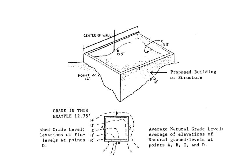
FIGURE 17.18A(2): MEASURING MAXIMUM HEIGHT OF BUILDING OR STRUCTURE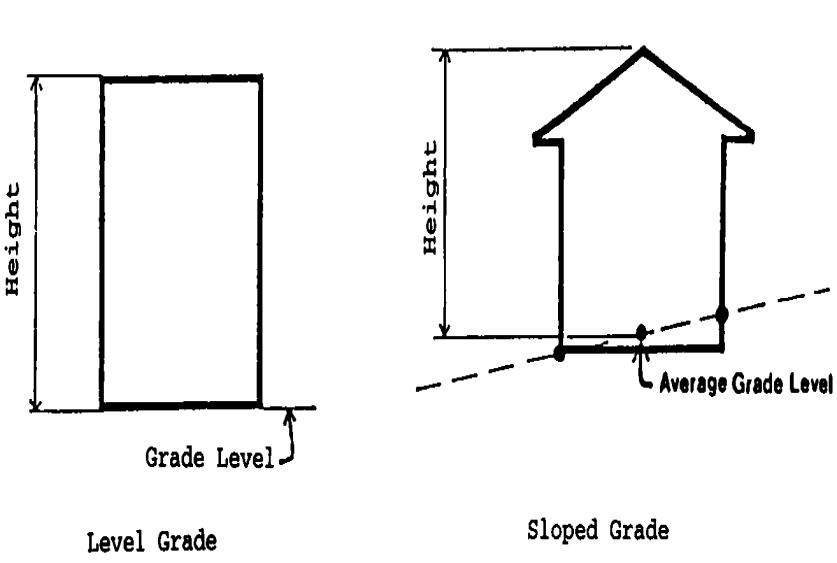
17.18A.090 Navigation aids.
No building or structure shall be constructed which would, in the judgment of the U.S. Coast Guard, interfere with any navigation or shipping aids. (Ord. 1362 § 2, 2005)
17.18A.100 Manufactured storage containers.
The use of manufactured storage containers for any use, including accessory uses, is prohibited. (Ord. 1467 § 3, 2010)