


Chapter 16.30
GEOLOGIC HAZARD AREAS
Sections:
16.30.010 Introduction.
A. Purpose. The purpose of this chapter is to safeguard public health, safety, and welfare by placing limitations on development in geologically hazardous areas consistent with the requirements of the Growth Management Act and Chapter 365-190 WAC.
B. Applicability and Exemptions.
1. Applicability. This chapter applies to all construction, development, earth movement, clearing, or other site disturbance which requires a permit, approval or authorization from the town in or within 100 feet of a geologic hazard area except for exempt activities listed in subsection (B)(2) of this section. Regulated geologic hazards include steep slope hazard areas, landslide hazard areas, seismic hazard areas, and volcanic hazard areas.
2. Exempt Activities and Uses. The following activities and uses are exempt from the provisions of this chapter:
a. Emergency activities which require immediate action to prevent an imminent threat to health, safety, or property. As soon as practical, the responsible party shall provide written notification to the responsible official and obtain all applicable permits;
b. The expansion, remodel, reconstruction, or replacement of any structure which will be set back from the geologic hazard area a distance which is greater than or equal to the setback of the original structure and which will not increase the building footprint by more than 1,000 square feet inside a steep slope hazard area, landslide area, or their buffers;
c. Any replacement, operation, repair, modification, installation, or construction by a state or locally franchised utility company in an improved right-of-way or utility corridor;
d. Normal and routine maintenance and repair of existing utility facilities, equipment, and appurtenances;
e. Any development activity on or within 100 feet of steep slopes that have been created through previous, legal grading activities is exempt from steep slope hazard regulations; and
f. All forest practices other than Class IV G (conversions).
3. This section applies to Class IV G forest practices (conversions).
C. Geologic Hazard Area Maps and Designation Criteria.
1. Maps.
a. Adopted Maps. The following maps are adopted by reference and in the town of Yacolt comprehensive growth management plan. GIS Map Store produces maps for free in the following link: Critical Areas Ordinances Maps (https://gis.clark.wa.gov/gishome/mapstore/%20-%20/mapProducts).
b. Identification. Geologic hazards are usually localized individual occurrences that may affect only small, separate areas. In addition, activities such as grading and clearing can create or increase slope instability where none was previously identified. Because of this, geologic hazard areas have not been identified on a site-specific basis.
c. Source Data. The approximate location and extent of geologic hazard areas are shown on the geologic hazard area maps adopted herein. Clark County will adopt updated mapping as more detailed information becomes available. The maps are intended to meet the designation criteria listed in WAC 365-190-080 and are based on the best available information, including:
i. Slope areas mapping for Clark County, Clark County department of assessment and GIS, and the town of Yacolt;
ii. Slope Stability of Clark County, Washington State Department of Natural Resources, 1975, and landslides mapped in Geologic Map of the Vancouver Quadrangle, Washington and Oregon, Washington State Department of Natural Resources, 1987; Construction of Liquefaction Susceptibility and NEHRP Soil-Type Maps for Clark County, Washington, Washington Department of Natural Resources, 2004;
iii. Volcanic hazard zonation for Mount St. Helens, Washington, U.S. Geological Survey, 1995; and
iv. Natural Resources Conservation Service, Soil Survey Geographic Database (SSURGO), 2004.
2. Designation Criteria. Along with geologic hazard area mapping, designation criteria for steep slope hazard areas, landslide areas, and seismic hazard areas are listed below. Where the geologic hazard area maps and designation criteria conflict, the designation criteria shall prevail.
a. Steep slope hazard areas are areas where there is not a mapped or designated landslide hazard, but there are steep slopes equal to or greater than 40 percent slope. Steep slopes which are less than 10 feet in vertical height and not part of a larger steep slope system, and steep slopes created through previous legal grading activity, are not regulated steep slope hazard areas. The presence of steep slope suggests that slope stability problems are possible.
b. Landslide hazard areas are areas that, due to a combination of slope inclination, soil type, and presence of water, are susceptible to land sliding in accordance with any of the following criteria:
i. Areas of previous slope failures including areas of unstable old or recent landslides;
ii. Areas with all three of the following characteristics:
(A) Slopes steeper than 15 percent;
(B) Hillsides intersecting geologic contacts with permeable sediment overlying a low permeability sediment or bedrock; and
(C) Any springs or groundwater seepage.
iii. Areas mapped by:
(A) Washington State Department of Natural Resources, Open File Report: Slope Stability of Clark County, as having potential instability, historical, or active landslides, or as older landslide debris; or
(B) The Washington State Department of Natural Resources Open File Report Geologic Map of the Vancouver Quadrangle, Washington and Oregon, as landslides.
D. Reasonable Use Assurance. Nothing in this section shall preclude the issuance of a single-family building permit on a lawfully created lot in accordance with YMC 16.20.110. [Ord. 569 § 2 (Exh. A), 2018.]
16.30.020 Standards.
A. General. The following requirements for development activities in geologic hazard areas list prohibited activities, buffer requirements, and setback requirements. This section describes required buffers and setbacks and general requirements for development activities in geologic hazard areas.
1. Development on steep slope hazard areas is regulated to prevent potential landslide damage by placing improvements away from steep slopes and leaving steep slopes in natural vegetation.
2. Development in landslide hazard areas is generally not allowed and requires buffers that keep vegetation in a natural state on and around the landslide hazard area.
3. Seismic hazards due to liquefaction, ground shaking amplification, and landslides exist for large areas of Clark County. Only detailed site analysis can determine how soils and structures will respond at a particular site. Site investigation requirements of the Washington State Building Code, as amended, are used to ensure that structures are built to minimum safety standards based on existing knowledge of earthquake hazard.
4. If an applicant wishes to perform development activities not allowed by subsections D and E of this section, a geologic hazard area study meeting the requirements of YMC 16.30.030(C) must be completed. The development proposal may be approved, approved with conditions, or denied based on the responsible official’s evaluation of the suitability of the mitigation measures proposed by the geologic hazard area study to protect life, safety, and slope stability on abutting properties.
B. Erosion Requirements. All activities on hillsides subject to severe erosion hazard must minimize erosion by following up-to-date BMPs.
C. Stormwater Requirements. For projects within 100 feet of steep slope hazard areas or landslide hazard areas, runoff shall not be infiltrated into the ground. Runoff should be directed through a watertight pipe beyond the base of the slope or landslide area and discharged to a suitable drainage way. An energy dissipating device shall be placed at the discharge point.
D. Steep Slope Hazard Areas.
1. Except for mineral extraction practices, development activity on or within 100 feet of slopes steeper than 40 percent that do not have a mapped or designated landslide hazard shall comply with the requirements of this section.
2. Buffer and Setback Distances.
a. For slopes greater than or equal to 40 percent and less than 100 percent, buffers shall extend a distance away from the toe of the slope that is equal to the vertical height of the slope divided by two, but not to exceed 15 feet (Figure 16.30.020-1). For slopes less than 100 percent, the toe of the slope is defined as a distinct break in slope at the base of a steep slope.
b. For slopes greater than 100 percent, the buffer shall extend a distance back from the toe of the slope equal to the height of the slope divided by two, not to exceed 15 feet. The buffer shall be measured horizontally from a plane, drawn tangent to the top of the slope at an angle of 45 degrees to the proposed structure (Figure 16.30.020-2).
c. The setback shall be eight feet beyond the buffer.
3. The responsible official may approve buffers and setbacks which differ from those required by subsection (D)(2) of this section if the applicant submits a geologic hazard area study described in YMC 16.30.030(C), which technically demonstrates and illustrates that the alternative buffer provides protection which is greater than or equal to that provided by the buffer required in subsection (D)(2) of this section.
4. The responsible official may increase buffers or setbacks where necessary to meet requirements of the Washington State Building Code, as amended.
5. All portions of steep slope hazard areas and steep slope buffers on the site which areas are planned to be undisturbed by permitted development activities shall be designated as landslide protection areas in accordance with this section.
6. Other than for exemptions listed in YMC 16.30.010(B) and 16.30.030(B), vegetation removal is not allowed on slopes over 40 percent without an approved geologic hazard area study described in YMC 16.30.030(C).
7. Buffers, landslide protection areas, and setbacks for steep slopes on projects having approved grading shall be based on regulated steep slopes that remain after that grading.
E. Landslide Hazard Areas.
1. A development proposal on a site containing a landslide hazard area shall meet the following requirements:
a. A minimum buffer of 50 feet shall be established from all edges of the landslide hazard area. The buffer shall be extended as required to mitigate a steep slope or erosion hazard or as otherwise necessary to protect the public health, safety, and welfare; and
b. All portions of landslide hazard areas and buffers shall be designated as landslide protection areas in accordance with YMC 16.30.030(B).
2. Other than exempt activities, clearing or alteration of a landslide is allowed only if the following conditions are met:
a. A development proposal does not decrease slope stability on contiguous properties;
b. Mitigation is based on best available engineering and geological practice and is described in an approved geologic hazard area study as specified in YMC 16.30.030(C); and
c. Such clearing or alteration of a landslide is certified safe as designed and under anticipated conditions by a registered geotechnical engineer or geologist licensed in the state of Washington.
3. Neither buffers nor a landslide protection area will be required if the activity meets the requirements of subsection (E)(2) of this section.
Slope Setback Diagrams
Figure 16.30.020-1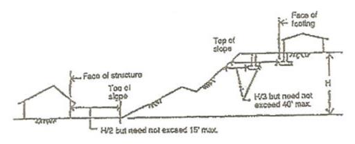
Figure 16.30.020-2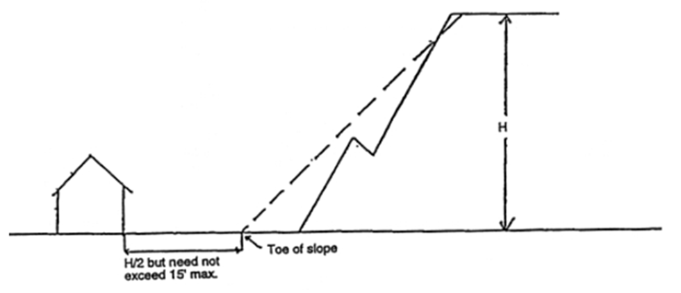
[Ord. 569 § 2 (Exh. A), 2018.]
16.30.030 Administration.
A. Binding Predetermination. Prior to submittal of a triggering application, a person may request from the responsible official a written binding predetermination of whether a probable regulated geologic hazard area exists on or within 100 feet of any parcel less than 40 acres. The predetermination shall be binding on the responsible official for a period of three years; provided, that such predetermination shall be subject to administrative appeal upon its application in conjunction with a triggering application. A complete predetermination application shall include a list of the submittal requirements for a site description under subsection (C)(3) of this section. Additional submittal requirements may later be required as a part of a geologic hazard area study under subsection (C)(4) of this section if the proposal intends to develop within a steep slope or landslide hazard area or their buffers.
B. Establishment of Landslide Protection Areas.
1. Steep slope hazard areas and landslide areas and buffers for which permanent protection is required pursuant to YMC 16.30.020(D) and (E) shall be designated landslide protection areas.
2. Landslide protection area requirements apply only to site plans and land divisions.
3. For all development activities subject to this section, landslide protection areas shall be delineated on binding site plans and plots which shall be recorded with the Clark County auditor.
4. A conservation covenant applicable to the designated landslide protection area shall be recorded in a form approved by the town attorney as adequate to incorporate the restrictions of this chapter.
5. Prior to any site development activity, the applicant shall mark with temporary markers in the field the boundary of all landslide protection areas required by this chapter, or the limits of the proposed site disturbance outside of the landslide protection areas, using methods and materials acceptable to the town of Yacolt.
6. Landslide protection area boundaries shall be permanently marked on the site prior to final inspection using methods and materials acceptable to the town of Yacolt.
7. Vegetation clearing requirements for development in landslide protection areas, steep slope hazard areas, and landslide hazard areas:
a. Clearing or vegetation removal in landslide protection areas, steep slope hazard areas, or landslide hazard areas or their buffers is prohibited except for:
i. Activities included in an approved geologic hazard area study as defined in subsection C of this section;
ii. Limited vegetation removal for surveying and testing necessary for development approvals;
iii. Emergency or fire hazard removal authorized by the district fire chief;
iv. Removal of nuisance vegetation using methods which minimize disruption of soil and non-nuisance vegetation;
v. Clearing necessary for placement or maintenance of fencing;
vi. Clearing necessary for hillside vegetation restoration;
vii. Clearing necessary for vegetation or resource conservation projects authorized by a public agency; and
viii. Clearing for three-foot-wide or narrower foot paths surfaced with wood, soil, or gravel.
b. Proposals for clearing may also be subject to other critical areas regulations. Wildlife habitat near streams, which have clearing requirements under the habitat conservation regulations, often overlap with steep slopes included in geologic hazard areas.
C. Submittal Requirements.
1. For development activity regulated by this chapter, submittal requirements will vary depending on the type of project and the type of hazard mitigations that are proposed. A review of a geologic hazard area will be conducted in conjunction with the primary development application. Projects are required to submit a basic site description sufficient to verify that the location of proposed building and access road improvements comply with buffers, setbacks, and vegetation preservation required by YMC 16.30.020(D) and (E). If a regulated activity is proposed within a geologic hazard area, additional information in the form of a geologic hazard area study must be provided to assure the project is feasible and will not cause an increased geologic hazard. The information required for a site description is included in subsection (C)(3) of this section. The requirements for a geologic hazard area study for projects wishing to build in a geologic hazard area are included in subsection (C)(4) of this section.
2. The responsible official shall waive parts of these submittal requirements if it is determined that they are not applicable to the proposed activity.
3. Site Description. As part of the development permit application, the following information describing the subject property and areas within 25 feet of the property lines or smaller area of concern as deemed appropriate by the responsible official, drawn to an engineering scale no larger than one inch equals 20 feet and no smaller than one inch equals 100 feet as deemed appropriate by the responsible official:
a. The site boundary lines;
b. The topography at contour interval of no greater than five feet;
c. The location and size of all existing and proposed site improvements including structures, wells, drain fields, drain field reserve areas, public and private right-of-way easements, and utilities;
d. The location of all drainage-flow characteristics, streams, groundwater seeps, springs, and evidence of seasonal surface water runoff or groundwater;
e. The location and extent of all existing and proposed grading activities and existing natural or artificial drainage control facilities and systems;
f. The location and description of all geologic hazards located on the site and observed on properties within 100 feet of site boundaries;
g. The general location of all vegetation and the general location, number, and description of all trees over six-inch diameter measured three feet above the ground; and
h. The location of all proposed buffers and setbacks.
4. Geologic Hazard Area Study. A geologic hazard area study is required if the proposed development does not comply with requirements of YMC 16.30.020(D), Steep Slope Hazard Areas, or YMC 16.30.020(E), Landslide Hazard Areas. Geologic investigation may also be required in some cases to meet Washington State Building Code, as amended, requirements for foundations and for seismic design. Geologic hazard area studies shall be prepared, stamped, and signed by a licensed geotechnical engineer or geologist. Based on the site characteristics and the information submitted by the applicant, the responsible official may require all or part of the following information to be included in a geotechnical report:
a. The requirements for the site description listed in subsection (C)(3) of this section;
b. Site geology information:
i. Topographic contours at two-foot intervals or as specified by the responsible official;
ii. Subsurface data that includes the exploration method, location of soil borings, borings, logs, soil and rock stratigraphy, and groundwater levels including seasonal changes;
iii. The location of landslides, or down-slope soil movement, faults, and geologic contacts on the subject property and adjacent properties;
iv. A site history that describes any prior grading, soil instability, or slope failure; and
v. A description of the site vulnerability to seismic events;
c. Geotechnical information and plan requirements:
i. A slope stability study and opinion of slope stability on the subject property and adjacent properties;
ii. Grading plan;
iii. Structural foundation requirements and estimated foundation settlements;
iv. Soil compaction criteria;
v. Allowable soil-bearing pressure for foundations, minimum footing widths, piling recommendations for foundations, and design pressure for retaining walls;
vi. Laboratory data and soil index properties for soil samples;
vii. Suitability for fill;
viii. Lateral earth pressures;
ix. Description of erosion vulnerability and an erosion control plan;
x. An evaluation of proposed surface and subsurface drainage in a stormwater control plan;
xi. Building limitations; and
xii. A vegetation management and restoration plan or other means for maintaining long-term stability of slopes;
d. A site evaluation that describes the suitability of the site to accommodate the proposed activity; and
e. Such additional information describing existing physical features for the site and surrounding area as required by the responsible official to complete review of the project under standards of the Washington State Building Code, as amended. [Ord. 569 § 2 (Exh. A), 2018.]