


Division 10-20.50:
Amendments to the Zoning Code Text and the Zoning Map
Sections:
10-20.50.010 Purpose
10-20.50.020 Applicability
10-20.50.030 Initiation of Amendments
10-20.50.040 Procedures
10-20.50.050 Appeal
10-20.50.060 Reversion of Conditional Zoning Map Amendment Approval
10-20.50.070 TNCP Zoning Map Amendments
10-20.50.010 Purpose
This division provides procedures for the amendment of the text of this Zoning Code and the Zoning Map consistent with applicable law.
(Ord. 2013-21, Amended, 11/05/2013 (Res. 2013-22))
10-20.50.020 Applicability
The procedures established in this division shall apply to all proposals to change the text of this Zoning Code, amend a parcel’s zoning designation, or a zone boundary on the Zoning Map. Amendments to the text of this Zoning Code and the Zoning Map shall only be made through the procedures described in this division and the adoption of an amending ordinance by the Council.
(Ord. 2013-21, Amended, 11/05/2013 (Res. 2013-22))
10-20.50.030 Initiation of Amendments
A. Owner Initiation.
1. A property owner, or an agent authorized by the property owner in writing, may submit:
a. A Zoning Map Amendment application for the owner’s property which is subject to the application; or
b. A Zoning Code Text Amendment to amend the zone and related provisions that directly regulate owner’s property.
2. In the event that a real property owner files an application for a Zoning Map amendment that includes property other than that owned by the applicant, the applicant shall file, on a form provided by the Director, a petition in favor of the request signed by the real property owners representing at least 75 percent of the land area to be included in the application. The petition shall bear the property owners’ signatures and addresses, the legal description and land area of each property represented on the petition, the total land area represented by the petition, and the total land area of individual properties included in the application.
B. City Council. The Director on behalf of the City Council may initiate a Zoning Code Text Amendment application or a Zoning Map Amendment application. An application initiated for amendments initiated by the City Council shall be signed by the Director.
C. Withdrawal. An applicant may withdraw a Zoning Code Text Amendment application or a Zoning Map Amendment application at any time. On behalf of the City Council, the Director may withdraw an application initiated by the City Council.
(Ord. 2020-11, Amended, 5/5/2020 (Res. 2020-17); Ord. 2013-21, Amended, 11/05/2013 (Res. 2013-22))
10-20.50.040 Procedures
A. Pre-Application Review. An optional pre-application review with the Director is recommended for all applications consistent with the procedures set forth in Section 10-20.30.040, Pre-Application Review by Director.
B. Citizen Review. All applications to amend the text of this Zoning Code or the Zoning Map shall include a process for citizen participation. Citizen participation shall, at a minimum, consist of a neighborhood meeting or a work session of the Planning Commission, as set forth below. The Director may implement additional procedures for citizen participation.
1. Zoning Map Amendments. The applicant shall schedule and conduct a neighborhood meeting in compliance with the procedures set forth in Section 10-20.30.060, Neighborhood Meeting. For requests to designate property as a landmark, historic property or historic district, a public meeting of the Heritage Preservation Commission held prior to any public hearing on the request shall satisfy the requirement for a neighborhood meeting.
2. Text Amendments to This Zoning Code.
a. A citizen review session shall be held at the Planning Commission work session that is scheduled for the consideration of any proposed text amendment. Landowners and other citizens potentially affected by the proposed text amendment will have an opportunity to comment on the proposed text amendment.
b. Notice of the citizen review session shall be given to adjacent landowners, citizens potentially affected by the proposed text amendments, and any person or group who has specifically requested notice regarding the application, in compliance with the review schedule on file with the Planning Section and A.R.S. § 9-462.04.A. The notice shall state the date, time, and place of the citizen review session and shall include a general explanation of the proposed text amendment. A copy of the notice shall be submitted to the Director. The form of notice to be used may vary according to the type of text amendment proposed. The form of notice given may include, but is not limited to, at least subsection (B)(2)(b)(1), (2) or (3) of this section, as well as optionally subsection (B)(2)(b)(4) of this section:
(1) First class mail sent to each property owner, as shown on the last assessment, whose property is directly governed by the changes;
(2) Inclusion in utility bills or other mass mailing distributed by the City;
(3) Publication in a local newspaper of general circulation distributed to City residents; or
(4) Posting on the City website.
c. The Planning Commission or Heritage Preservation Commission may take into account issues and concerns raised by landowners and other residents potentially affected by the proposed text amendments. Prior to the Council hearing, the Planning Commission or Heritage Preservation Commission shall report on the issues and concerns raised during the citizen review session.
C. Application Requirements.
1. Applications for Zoning Code text or Zoning Map amendments shall be submitted to the Director in writing on a form prescribed by the City in compliance with Section 10-20.30.020, Application Process. The application shall include the information and materials specified in the checklist, together with the required fee established in Appendix 2 (Planning Fee Schedule).
2. The submittal requirements for applications for Zoning Map amendments vary based on the size of the development and whether an amendment to the General Plan is required, as set forth below:
a. Small-Scale Zoning Map Amendments. These are applications for Zoning Map amendments for which no infrastructure analyses typically required by the Engineering Standards are necessary and which are determined by the Director to be consistent with the General Plan and compatible with surrounding development. These would typically include developments located on small lots or parcels, such as, for example, a duplex. For such applications, the requirements for a site analysis and concept zoning plan may be waived if, in the opinion of the Director, they are not warranted based on the conditions in subsections (C)(3)(b) and (c) of this section.
b. Medium-Scale Zoning Map Amendments. These are applications for Zoning Map amendments for developments that fall below the thresholds for large-scale Zoning Map amendments and that meet the following thresholds:
(1) Require a minor amendment to the General Plan as defined in Section 11-10.20.020, Major Plan Amendments and New Elements; and/or
(2) Require infrastructure analyses in accordance with the Engineering Standards.
For such applications, the minimum submittal requirements for a concept zoning plan are required including a development agreement (see Section 10-20.40.060, Development Agreements) when needed to define applicant/City obligations for such elements as off-site infrastructure improvements, affordable housing, or open space.
c. Large-Scale Zoning Map Amendments. These are applications for Zoning Map amendments that meet the following thresholds:
(1) Include residential developments over 100 units, or all commercial developments over 50,000 square feet or 15 acres, or all industrial and research and development uses over 150,000 square feet or 20 acres; or
(2) Require a major amendment to the General Plan as defined in Section 11-10.20.020, Major Plan Amendments and New Elements.
For such applications, the minimum submittal requirements for a concept zoning plan are required, as well as infrastructure analyses as required by the Engineering Standards. Compliance with the requirements of Section 10-20.30.070, Additional Requirements for Citizen Outreach, may also be required depending on the size of the proposed development. In addition, a development agreement that defines applicant/City obligations such as off-site infrastructure improvements, affordable housing, or open space is required to be submitted at such time as impact analyses have been accepted by the City Engineer or Utilities Director (see Section 10-20.40.060, Development Agreements).
d. Multi-Phase Scale Zoning Map Amendments. These are applications for Zoning Map amendments for very large projects that meet the following thresholds:
(1) Are complex in terms of their associated development issues; involve the future subdivision of land and the potential for multiple land developers; include multiple land use types; include multiple zone designations; involve complex utility infrastructure issues; and will require the design and layout of an internal street network to connect to existing streets; or
(2) Require a major amendment to the General Plan as defined in Section 11-10.20.020, Major Plan Amendments and New Elements.
For such applications, the minimum submittal requirements for an enhanced concept zoning plan are required which includes the additional information described in the checklist.
3. The Director may request any other information that is relevant to assist in the review of a Zoning Code text or Zoning Map amendment. The Director’s decision to require additional information to assist the Planning Commission and Council in their review of the Zoning Code text or Zoning Map amendment shall be based on whether any of the following apply:
a. The need to ensure that any General Plan policies and requirements that may be specific to the subject property are addressed either in a written report or on submitted plans;
b. The proposed development anticipated in compliance with the requested zoning designation while consistent with the General Plan Land Use Map may not be generally compatible with surrounding uses and neighborhoods based on the size, height, scale, mass and proportion of the proposed development (therefore a three-dimensional bulk and mass analysis may be required); or
c. The subject property is encumbered with natural resources such as floodplains, forests, and steep slopes, and compliance with the resource protection overlay (see Division 10-50.90, Resource Protection Standards) is required.
4. The Director may waive the requirements for any of the information required in this subsection (C) if it is determined that such information is not necessary in order to complete a review of the requested Zoning Map amendment.
5. An applicant may submit additional detail and more information than the minimum required in this subsection (C).
D. Application Procedures – A Two-Pronged Approach. An applicant requesting an amendment to the Zoning Map regardless of the scale of the project as defined in subsection (C)(2) of this section may elect to pursue either one of the two approaches described below:
1. Direct Ordinance with a Site Plan. The Direct Ordinance with a Site Plan process, illustrated in Figure 10-20.50.040B, provides an applicant with a shorter approval process with fewer steps. This process enables an applicant to submit fully developed site plans with all supporting information required for site plan review and approval (Section 10-20.40.140) concurrently with the Zoning Map amendment application. Once the Zoning Map amendment is approved by the Council, then the applicant may proceed directly to construction plan and building permit review (Section 10-20.40.030, Building Permits and Certificates of Occupancy), and no additional site plan review is required. However, if the Council adds conditions of approval that require substantial amendments to the site plan, as determined by the Director, then a revised application shall be submitted for site plan review and approval (Section 10-20.40.140) prior to building permit review and approval.
2. Authorization to Rezone with a Concept Zoning Plan. The Authorization to Rezone with a Concept Zoning Plan process illustrated in Figure 10-20.50.040C decouples a Zoning Map amendment application from an application for site plan review and approval. In this case, a concept zoning plan would be developed and submitted in support of the zone change request, and, assuming Council approval of the Zoning Map amendment, then a complete site plan application would be submitted at a later time in accordance with the requirements of Section 10-20.40.140, Site Plan Review and Approval.
E. Staff Review.
1. An application for a text amendment to this Zoning Code or an amendment to the Zoning Map shall be submitted to the Director and shall be reviewed and a recommendation prepared in compliance with the review schedule on file with the Planning Section.
2. The Director’s recommendation shall be transmitted to the Planning Commission in the form of a staff report prior to a scheduled public hearing. The staff report shall include the following:
a. An evaluation of the consistency and conformance of the proposed amendment with the goals of the General Plan and any applicable specific plans;
b. A recommendation on the amendment and the grounds for the recommendation based on the standards and purposes of the zones set forth in Division 10-40.20, Establishment of Zones; and
c. A recommendation on whether the text amendment or Zoning Map amendment should be granted, granted with conditions to mitigate anticipated impacts caused by the proposed development, or denied.
3. A copy of the staff report shall be made available to the public and any applicant prior to the public hearing.
F. Findings for Reviewing Proposed Zoning Map Amendments and Text Amendments.
1. An amendment to the Zoning Map or the text of this Zoning Code may be approved only if all of the following findings are made, as applicable to the type of amendment:
a. Findings for Zoning Map Amendments.
(1) The proposed amendment is consistent with and conforms to the goals of the General Plan and any applicable specific plans;
(2) The proposed amendment will not be detrimental to the public interest, health, safety, convenience, or welfare of the City and will add to the public good as described in the General Plan; and
(3) The affected site is physically suitable in terms of design, location, shape, size, operating characteristics and the provision of public and emergency vehicle (e.g., fire and medical) access and public services and utilities (e.g., fire protection, police protection, potable water, schools, solid waste collection and disposal, storm drainage, wastewater collection, treatment, and disposal), to ensure that the requested zone designation and the proposed or anticipated uses and/or development will not endanger, jeopardize or otherwise constitute a hazard to the property or improvements in the vicinity in which the property is located.
b. Findings for Text Amendments.
(1) The proposed amendment is consistent with and conforms to the objectives and policies of the General Plan and any applicable specific plan;
(2) The proposed amendment will not be detrimental to the public interest, health, safety, convenience or welfare of the City; and
(3) The proposed amendment is internally consistent with other applicable provisions of this Zoning Code.
2. If the application is not consistent with and does not conform to the General Plan and any other applicable specific plan, the applicable plan must be amended in compliance with the procedures established in Chapter 11-10, General Plans, prior to considering the proposed amendment. The Director shall determine if a General Plan (or other applicable specific plan) amendment is required and whether the amendment would be a minor or major plan amendment, based upon the criteria set forth in Section 11-10.20.020, Major Plan Amendments and New Elements.
3. An application for a major amendment to the General Plan and a Zoning Map amendment for the same development site/application will not be considered at the same time. If it is determined that a major amendment to the General Plan is required, then the application for a Zoning Map amendment shall wait until the major plan amendment has been approved.
4. An amendment to the General Plan map that is determined to be minor may be considered and heard at the same time as the application for a Zoning Map amendment.
G. Notification. Public notification of an amendment to the text of this Zoning Code or the Zoning Map shall be provided in compliance with Section 10-20.30.080, Notice of Public Hearings. When the proposed amendment involves land that abuts unincorporated areas of Coconino County, the Director shall send a copy of the notice of public hearing to the planning agency of Coconino County.
H. Planning Commission Public Hearing.
1. If the Director determines that the requested Zoning Map amendment would not require a General Plan (or other applicable specific plan) amendment, the Director shall give notice and the Planning Commission shall conduct a public hearing on the application.
2. The Planning Commission may request additional information that is relevant to assist in the review of a Zoning Code text or Zoning Map amendment subject to the criteria established in subsection (C)(3) of this section.
I. Action by the Planning Commission. The Planning Commission shall render its decision in the form of a written recommendation to the Council. The recommendation shall include the reasons for the recommendation (refer to Section 10-20.30.090, Findings Required). The Planning Commission may recommend approval, approval with modifications and/or conditions, or denial of the proposed amendment. If the Planning Commission fails to make a recommendation to the Council within 30 days after closing the public hearing, the Planning Commission shall be deemed to have recommended denial and the application shall be scheduled for public hearing and action by the Council.
J. Council Public Hearing.
1. Upon receipt of a recommendation from the Planning Commission, the Council shall conduct a public hearing and take action on any application to amend the text of this Zoning Code or the Zoning Map. The Council may refer the application back to the Planning Commission for further study and a revised recommendation.
2. The Council may request additional information that is relevant to assist in the review of a Zoning Code text or Zoning Map amendment subject to the criteria established in subsection C.3. of this section.
K. Council Action. The Council shall review the proposed amendment or Zoning Map amendment and the recommendations of the Planning Commission and Director, and shall grant or deny the application.
L. Ordinance Effective Date. An ordinance granting a Zoning Map amendment is, by State statute, subject to referendum and shall not become effective until 30 days after the date of adoption or the date the final ordinance is available from the City Clerk, whichever is later. The effective date of the ordinance is not necessarily the effective date of Zoning Map amendment. The effective date of the Zoning Map amendment is when compliance with conditions of approval is completed and certified by the Director. No permits or development approvals may be granted that are in furtherance of the Zoning Map amendment request until the 30 days have lapsed and the conditions of approval have been met.
M. Protest Procedures. A protest against a proposed amendment may be filed in writing by the owners of 20 percent or more of either:
1. The area of the parcel(s) of land included in the proposed Zoning Map amendment; or
2. The area of those parcel(s) of land immediately adjacent in the rear or any side of the subject property(ies) extending 150 feet from the subject property(ies); or
3. The area of those parcel(s) of land directly opposite the subject property(ies) extending 150 feet from the street frontage of the opposite parcels of land.
Such protest shall be hand-delivered to the City Clerk by no later than 12:00 noon five business days after the City Council first considers the application at a public hearing. If a timely protest is filed, the amendment shall not become effective except by a favorable vote of three-fourths of all members of the Council. If any member of the Council is unable to vote on such a question because of a conflict of interest, then the required number of votes for passage of the question shall be three-fourths of the remaining membership of the Council; provided, that such required number of votes shall in no event be less than a majority of the full membership of the Council.
N. Conditions of Approval.
1. The Council may impose such reasonable and appropriate conditions and safeguards as are necessary to a Zoning Map amendment request to:
a. Carry out the purposes of the General Plan or other applicable specific plans;
b. Ensure all required findings are satisfied and compatibility with adjacent land uses has been assured;
c. Reduce or minimize any potentially injurious effects on adjacent properties;
d. Protect the character and scale of the neighborhood; or
e. Protect the health, safety, or general welfare of the community.
2. Such conditions of approval may include, but are not limited to:
a. Structural or vegetative screening greater than that required by the landscaping and screening standards of Division 10-50.60, Landscaping Standards, to buffer the surrounding land uses from the proposed use;
b. Limitations on the allowable uses permitted within the approved zone that are more restrictive than the otherwise allowed uses established in Division 10-40.30, Non-Transect Zones;
c. Limitations on the height, setbacks, GFAR, or other standards specific to the approved zone which are more restrictive than the applicable requirements of Division 10-40.30, Non-Transect Zones, or 10-40.40, Transect Zones;
d. Limitations on the height, size, or illumination of signs more restrictive than the applicable requirements of Division 10-50.100, Sign Standards;
e. Limitations on the conduct of the proposed use, such as, but not limited to, hours of operation, or use of loudspeakers or external lighting, as necessary to protect adjacent land uses;
f. Public dedication of necessary right-of-way for streets, alleys, drainage ways, and public utilities, and installation of off-site improvements as are reasonably required by or related to the effect of the Zoning Map amendment;
g. A stipulation that the applicant schedule an additional neighborhood informational meeting in compliance with the procedures set forth in Section 10-20.30.060, Neighborhood Meeting, prior to submittal of an application for site plan review and approval (Section 10-20.40.140) so that interested residents may view the final site plan and other applicable plans for consistency with approved conditions of approval. The applicant shall create a written summary of the meeting, which shall be filed with the Director; and
h. A stipulation that if the subject property is not located within the Resource Protection overlay zone (see Section 10-40.50.030, Overlay Zones), then compliance with the resource protection standards established in Division 10-50.90, Resource Protection Standards, is required.
3. A violation of any condition shall be considered to be a violation of these regulations.
4. The concept zoning plan upon which the Zoning Map amendment may be approved establishes the development entitlement for the subject property. As the approval is based on a concept zoning plan, some flexibility in the layout of the property may therefore be approved by the Director; provided, that no additional external impacts to surrounding uses and infrastructure will result and there is no increase or decrease in GFAR, lot coverage, number of dwelling units, or building height in excess of that permitted in Table 10-20.40.090.A. (Types of Minor Modifications Allowed). As an example, if the concept zoning plan shows a building placed in close proximity to a street so that it has a strong relationship to the street and with parking behind it, the location and shape of the building may be adjusted; provided, that the same relationship to the street with the parking area in the rear is maintained. Similarly, internal circulation or parking areas may be adjusted; provided, that there is no impact to the location or design of access driveways or streets, and no additional impacts on adjoining City streets.
O. Figure 10-20.50.040.A., Amendments to the Zoning Code Text, summarizes the procedure for amending the text of this Zoning Code. Figure 10-20.50.040.B. (Amendments to the Zoning Map (Direct Ordinance with a Site Plan Process)) and Figure 10-20.50.040.C. (Amendments to the Zoning Map (Authorization to Rezone with a Concept Zoning Plan Process)) summarize the procedures for amending the Zoning Map following the two processes described in subsection D. of this section.
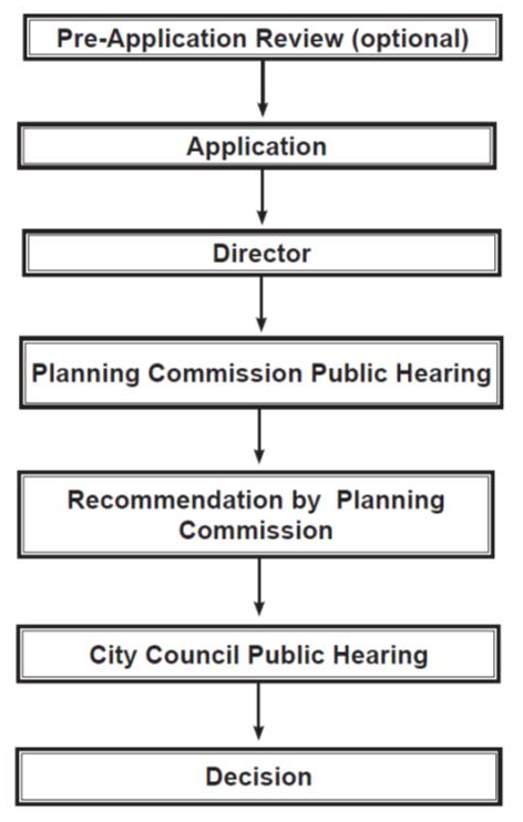
Figure 10-20.50.040.A.
Amendments to the Zoning Code Text
|
Note: Action and public hearings by the Director, Planning Commission, or City Council will be completed in accordance with the review schedule on file with the Community Development Division. |
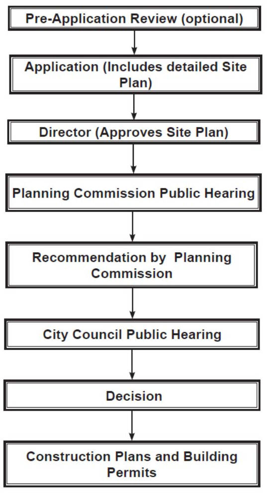
Figure 10-20.50.040.B.
Amendments to the Zoning Map (Direct Ordinance with a Site Plan Process)
|
Note: Action and public hearings by the Director, Planning Commission, or City Council will be completed in accordance with the review schedule on file with the Community Development Division. |
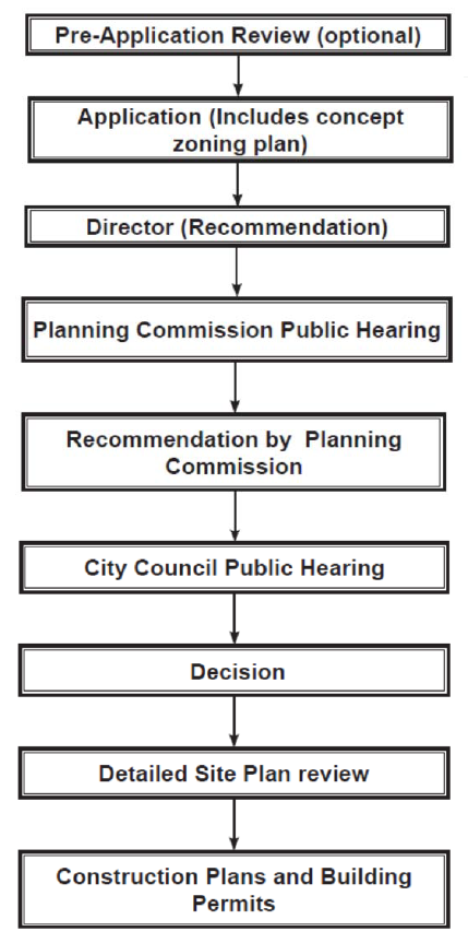
Figure 10-20.50.040.C.
Amendments to the Zoning Map (Authorization to Rezone with a Concept Zoning Plan Process)
|
Note: Action and public hearings by the Director, Planning Commission, or City Council will be completed in accordance with the review schedule on file with the Community Development Division. |
(Ord. 2020-11, Amended, 5/5/2020 (Res. 2020-17); Ord. 2016-07, Amended, 2/16/2016 (Res. 2016-02); Ord. 2013-21, Amended, 11/05/2013 (Res. 2013-22))
10-20.50.050 Appeal
A property owner may appeal a dedication or exaction required as a condition of granting approval for the use, improvement or development of real property to an administrative hearing officer designated in compliance with Section 10-20.80.040, Appeals of Dedications and Exactions.
(Ord. 2013-21, Amended, 11/05/2013 (Res. 2013-22))
10-20.50.060 Reversion of Conditional Zoning Map Amendment Approval
A. The Council may approve a Zoning Map amendment conditioned upon a schedule for development of the specific use or uses for which a Zoning Map amendment is requested. If, at the expiration of this period, the property has not been improved for the use for which it was conditionally approved, the Council may take action to extend, remove, determine compliance with the schedule for development, or the Council may set a public hearing to consider a reversion of the property to its former zoning through legislative action.
B. An applicant desiring a time extension must make an application to the Director to amend the conditions of the Zoning Map amendment approval at least 60 days prior to the date of the expiration of the original approval in compliance with the Review Schedule on file with the Planning Section. A conditional Zoning Map amendment approval subject to reversion may be extended only by going through the process for a Zoning Map amendment. Upon the expiration of the specified time period, if no application for amendment to the zoning conditions has been submitted, then the Planning Commission and Council, after notification by certified mail to the owner and applicant who requested the Zoning Map amendment approval, shall schedule public hearings to take administrative action to extend, remove, or determine compliance with the schedule for development or take legislative action to cause the property to revert to its former zone. Public hearings before the Planning Commission and Council shall be noticed in compliance with the provisions of Section 10-20.30.070, Notice of Public Hearings.
C. In public hearings to consider amendments to the schedule for development, the applicant shall provide substantial evidence to the Planning Commission and Council that:
1. In spite of the good faith efforts of the applicant, circumstances beyond the applicant’s control have prevented the timely pursuit of the development and completion of the necessary requirements within the original authorized time period;
2. The applicant has completed substantial property improvements, incurred substantial nonrecoverable monetary expenditures or commitments, or has completed supporting development-related improvements, or retained the services for preparation of supporting data in reliance upon the approval of the request; or
3. In either instance, the applicant is in good faith, continuing to diligently pursue implementation of the development to the degree authorized by the City.
D. Changes to previously approved conditional Zoning Map amendment applications may be subject to the following:
1. Modification of previously required conditions of approval as warranted by interim changes in the area and/or to ensure continued compatibility with any improvements within the context area; or
2. Site plan revisions as necessary to comply with any ordinance or Zoning Code amendments that may have taken effect since the time of the original approval.
(Ord. 2013-21, Amended, 11/05/2013 (Res. 2013-22))
10-20.50.070 TNCP Zoning Map Amendments
A. Application Requirements. An application for a Zoning Map amendment for a Traditional Neighborhood Community Plan (TNCP) shall follow the requirements of Division 10-30.80, Traditional Neighborhood Community Plans. A Zoning Map amendment request to apply transect zones within a TNCP shall only occur after a request for a General Plan amendment to the Traditional Neighborhood or Mixed Use land use designation, if needed.
B. Findings. The Planning Commission and Council shall base their decision on a TNCP on the following findings:
1. The proposed development meets the intent and purpose of a TNCP established in Division 10-30.80, Traditional Neighborhood Community Plans;
2. The proposed development is consistent with and conforms to the goals of the General Plan;
3. The proposed development will not be detrimental to the public health, safety or welfare or materially injurious to properties or improvements in the vicinity; and
4. The proposed development will promote or preserve environmental quality, conserve energy usage and energy resources (including for example, the protection of adequate sunlight for use of solar energy systems), and promote water conservation and reuse.
C. Conditions for Zoning Map Amendment. If the Council approves the application of transect zones within a TNCP, the Zoning Map shall be changed by ordinance. The Council may, as necessary, attach conditions that are reasonably determined to mitigate possible impacts from the proposed development.
D. Application Requirements. To ensure that the public’s health, welfare and safety are preserved and that provision is made for harmonious and appropriate development consistent with the goals and objectives the General Plan as amended, the Director may require submittal of the following information in addition to the requirements in Division 10-30.80, Traditional Neighborhood Community Plans, and the requirements of the City’s application form:
1. Space for public use, such as parks, schools, recreation areas and trails;
2. Coordination of street layout with existing or planned thoroughfares;
3. Adequate fire protection;
4. Additional mitigation measures to address issues of public safety and welfare, and environmental protection; and
5. Any other information as may be determined necessary by the Director to complete an analysis and review of the TNCP.
The Director may waive in writing upon request of an applicant any of the required information if it is determined that such information is not applicable.
E. Public Charrette Process. A multi-day public design charrette is required as part of the Zoning Map amendment to apply transect zones within a TNCP, unless a multi-day public design charrette was conducted as part of a request for a General Plan amendment in which case the Director may waive this requirement. The required design charrette may be used as one method to fulfill the citizen review requirements of Section 10-20.30.060, Neighborhood Meeting, or Section 10-20.30.070, Additional Requirements for Citizen Outreach.
F. Adoption of Development Plans. The development plans (for example, the illustrative plan, regulatory plan or other plans used to describe and illustrate the development) and supporting documents (for example, a development agreement) submitted with the TNCP must be approved and adopted by the Council and included or referenced in the ordinance establishing the transect zones. All public and private development within the TNCP shall comply with the development plans and other supporting statements and documents as approved and adopted by the Council.
G. Amendment Procedures. Amendments to TNCP and applicable transect zones shall be in substantial conformance with the objectives of Division 10-30.80, Traditional Neighborhood Community Plans, and the General Plan. A written application to amend one or more of the transect boundaries or regulations may be initiated by the property owner or the owner’s agent or the Council.
1. The application shall be accompanied by a statement documenting the need for the amendment, any plans and other documents in support of the amendment as determined by the Director, and the required amendment application fee established in Appendix 2, Planning Fee Schedule.
2. The Director shall determine if the amendment would result in a substantial change to the TNCP. A substantial change is one which:
a. Allows uses not otherwise permitted in the regulating plan for the TNCP or a portion of the TNCP;
b. Deviates from a TNCP policy such that the proposed layout, design and functionality of the TNCP is no longer possible or viable;
c. Increases or decreases the number of proposed residences per acre by 10 percent or more, or exceeds the maximum number of dwelling units permitted within the TNCP;
d. Varies the building height, lot coverage, building setbacks or other standards established in the form-based code by 10 percent or more of that delineated in the adopted regulating plan and form-based code for the TNCP;
e. As a consequence of more than one non-substantial change submitted concurrently, cumulatively results in a significant change in the objectives or goals of the TNCP as determined by the Director;
f. Results in a significant change in pedestrian or traffic circulation within the TNCP or in the surrounding area;
g. Could have significant impact on areas adjoining the TNCP;
h. Could have significant negative impacts on natural, heritage, cultural or architectural resources; or
i. Results in a significant change in the TNCP transect zone boundaries from those approved for the original TNCP.
3. If the request is considered to be a substantial change, the Director shall bring the amendment request before the Planning Commission and Council following the procedures established in this Section 10-20.50.040, Procedures. When a change to the originally approved TNCP is determined to be substantial, the Director may require submittal of additional items, including but not limited to documentation (in written or map form) explaining the reason for the change, the benefits to the applicant and to the community resulting from the change, and any other information required to assist in the review of the amendment application.
4. The Director may administratively approve non-substantial amendments to the TNCP following the provisions of Section 10-20.40.090, Minor Modifications to Development Standards.
5. When requested in writing by the applicant, the Director may authorize a delay in the plan amendment process.