Chapter 17.04
MOUNTAINSIDE DEVELOPMENT REGULATIONS
Sections:
17.04.010 Introduction.
17.04.020 Purpose.
17.04.030 Implementation.
17.04.040 Mountainside definitions.
17.04.050 Review and development process.
17.04.060 Documentary requirements and certification.
17.04.070 Development standards.
17.04.080 Density and subdivision/lot split standards.
17.04.010 Introduction.
As valuable scenic resources, the mountains and hillsides of the Town of Pinetop-Lakeside provide a permanent visual presence that exemplifies what is unique about this community. They define the location and character of the Town, shape our sense of place, and contribute to the Town’s identity. These land forms, their foothills, and other areas where there exists a fifteen percent (15%) or greater slope, offer a desirable setting visible to the entire area and an intrinsic aesthetic value to the Town; therefore they require unique standards resulting from the characteristics of mountainside terrain.
17.04.020 Purpose.
This chapter exists to establish provisions to: (a) regulate the intensity of development; (b) preserve and protect the mountainside environment; (c) provide for the safety and welfare of the Town and its residents; and (d) establish rules and procedures for review by the Development Review Committee of mountainside development, building, and construction plans through the implementation of the following:
A. Require buildings and other improvements to adapt to the natural mountainside topography thereby reducing the scarring effects of roads, drives, building pads and cut and fill slopes.
B. Encourage all improvements to be designed and constructed in a manner that minimizes the impact of development from viewpoints throughout the Town and adjacent slopes.
C. Prevent unnecessary grading or stripping of vegetation, preserve drainage patterns, protect the public from natural hazards of storm water runoff and erosion, and require re-vegetation in order to maintain the natural landscape environment.
D. Preserve visual open space, unique natural features, wildlife habitats, and retain the integrity and natural states of dominant peaks and ridges.
E. Provide development and construction practices and methods to ensure greater forest protection in mountainside development areas.
This chapter endeavors to enhance design quality so that the resulting development maintains the essential natural characteristics and context of the mountainside consistent with the goals and policies of the Town’s General Plan.
17.04.030 Implementation.
The provisions of this chapter shall apply to all lots where the natural terrain causes the average lot slope to be fifteen percent (15%) or greater (see example below). However, a fifteen (15%) percent or greater slope created by a natural wash on land that would otherwise not be classified as mountainside land shall be exempt from the mountainside regulations. Mountainside lands are also subject to special provisions relating to Minor Land Division and Subdivision Development as set forth in Title 16, the Subdivision Code. However, if there is a conflict between these Mountainside Development Regulations and other Town Regulations or the Town Code, these provisions shall prevail when Mountainside Development Regulations are more restrictive.
Figure 1 – 15% Slope
17.04.040 Mountainside definitions.
Where definitions are not included in this section, the definitions in Chapter 16.04.060 shall control. For purposes of this Section, the terms contained in this Section shall have the following meanings:
A. "Acre" means 43,560 square feet as measured on the horizontal plane.
B. "Alter the Mountain Top Ridge Line" means any development on the primary ridgeline shown on Figure 2a and b that disturbs or alters the natural mountain top profile.
C. "Applicant" means the person or entity desiring to improve or otherwise engage in any development of property in the Mountainside Development Area, including the owner of the property and any agents acting on behalf of the owner.
D. "Average Lot Slope" means the average slope of the natural terrain within the boundaries of a particular lot. The slope will be calculated by taking the average of a minimum of two slope lines per lot. These slope lines shall run the entire length of the lot and be as near to perpendicular as practical to the natural contour lines.
E. "Building Pad" means the total area under roof of all structures proposed for the property.
F. "Building Pad and Slope" means the percent of slope measured at right angles to the natural contours along a line passing through the center of the proposed building and termination at the end of the disturbed area limits of the building site.
G. "Code" means the Town Code of the Town of Pinetop-Lakeside, Arizona in effect as of the date of these Regulations and as may be amended.
H. "Commission" means the Planning and Zoning Commission of the Town of Pinetop-Lakeside.
I. "Committee" means the Development Review Committee of the Town of Pinetop-Lakeside.
J. "Conservation" means the retention or acquisition of land for the purpose of preservation in a natural state.
K. "Conservation Easement" means a permanent open space easement granted to the Town or to a public land trust to prohibit development of property including roads and utilities and to retain and preserve the land for the scenic enjoyment of the general public.
L. "Council" means the Town Council of the Town of Pinetop-Lakeside.
M. "Cut" means the land surface which is shaped through the removal of soil, rock, or other materials.
N. "Development" means any grading, excavation or other construction, or the preparation for construction including the removal of natural vegetation, earth moving or other preconstruction work which alters the natural features or natural grade of the lot.
O. "Disturbed Area" means that area of natural ground, including the footprint of the residence, that has been or is proposed to be altered through grading, cut and fill, removal of natural vegetation, placement of material, trenching, or by any means that causes a change in the undisturbed natural surface of the land or natural vegetation.
P. "Fill" means the deposit of soil, rock, or other material placed by man.
Q. "Finished Grade" means the final grade and elevation of the ground surface after grading is completed.
R. "Footprint" means that area of the residence measured from the outside walls (excluding any overhanging portions) which includes indoor uses such as attached garage, carports, utility room, laundry, etc., and including outdoor uses such as patios and breezeways.
S. "Grading" means any excavating, or filling or combination thereof, including the conditions resulting from any excavation or fill.
T. "Lot" means a parcel of land occupied or intended for occupancy by one main building, together with any accessory buildings and having adequate frontage on a public or private street.
U. "Mass" means the size and shape of a new facility or land form, prepared to scale.
V. "Massing Study" means the visual representation of a new facility, whether it is a road, building or other physical feature. It must show the new facility and/or the changes to the existing land, such that the viewer can understand the size and shape of the finished project, and how it fits into the existing landscape. It can be a drawing, a computer model or a rendering.
W. "Mountain Top" means the highest point on a mountain with a minimum of two hundred fifty (250) feet relief from its base to its highest peak.
X. "Mountainside Development Area" means those lands where the natural terrain has a slope of fifteen (15%) percent or greater. However, a fifteen (15%) percent or greater slope, created by a natural wash on land that otherwise would not be classified as mountainside land shall be exempt from the Mountainside regulations.
Y. "Mountainside Wash" means any creek, stream, wash, channel, or other body of water having historical banks and with a flow rate equal to or greater than two (2) cubic feet per second based on a one hundred (100) year storm event.
Z. "Natural Features, Significant" includes washes, significant vegetation, and significant rock outcroppings provided these features are in their undisturbed natural state.
aa. "Natural Grade" means the undisturbed natural surface of the land, including washes.
bb. "Primary Ridge line" means the line running from the highest peak on a mountaintop to the next highest peak along a natural ridge.
cc. "Retaining Wall" means a wall or terraced combination of walls, including negative edge pools, used solely to retain more than eighteen (18) inches of material or water but not to support or to provide a foundation or wall for a building.
dd. "Raw Spill Slope" means an area created by causing or allowing earth or other material to fall, flow, or run down the slope, thereby creating a change in the natural appearance and topography.
ee. "Rock Outcroppings, Significant" means any surface rock or group formation of rocks covering an area of two hundred (200) square feet or larger or any surface rock formation with a height greater than ten (10) feet from the surrounding grade.
ff. "Sheet Flow" means a shallow and wide overland flow of water.
gg. "Subterranean" means that space which lies totally underground, and which cannot be accessed from outside the exterior perimeter of the structure on the same horizontal plane which originates at that point where the building intersects the ground.
hh. "Town" means the Town of Pinetop-Lakeside.
ii. "Vegetation, Significant" means a stand of trees having a height greater than fifteen (15) feet or three (3) or more trees, located within a radius of fifteen (15) feet, each having a height greater than fifteen (15) feet.
jj. "View Fencing" (view fence) means fencing that is constructed in such a manner as to achieve eighty (80%) percent overall openness.
17.04.050 Review and development process.
The Development Review Committee shall review Development plans, as outlined in section B of Chapter 17.04.060, prior to any other Development permit. The review and development process consists of up to five (5) stages, depending upon the nature and scope of the proposed Development:
A. Pre-submittal Meeting: If the proposed building pad covers natural terrain having a slope of less than fifteen (15%) percent, the applicant may request a pre-submittal meeting with Town staff to determine whether or not the applicant’s plans may be submitted without being stamped and sealed by a licensed professional. In this pre-submittal meeting, Town staff shall consider lots where no grading has occurred. If grading has occurred on the lot, Town Staff will only consider the lot if it has been restored following the guidelines in paragraph C.8 of 17.04.070.
B. Concept Plan Review Meeting: The applicant, together with their architect and/or engineer, shall submit a completed application and the required fees to the Community Development Director at the time they request a concept plan review meeting (pre-submittal meeting) with the Development Review Committee. The applicant’s architect and/or engineer do not need to be present at the concept plan review meeting. The purpose of this meeting is to discuss, review, and give suggestions and guidance to the applicant regarding the proposed development including: the entire subdivision layout, if a subdivision; the location of the building pad and accessory uses; how these relate to Significant Natural Features; the preservation of existing vegetation; grading concepts and their adaptation to the natural mountainside topography; and how the requirements pursuant to these Mountainside regulations and purpose statement will guide the proposed development.
C. Formal Development Review Committee Meeting: At this stage, in addition to those materials previously submitted, the applicant shall submit all materials outlined in 17.04.060 to the Town Engineer. The Development Review Committee shall then review the submittal for compliance with the goals, purposes, and specific criteria of this ordinance and either approve, approve with conditions or changes, or deny the submittal.
D. Building Permit Review: The final construction plans for a mountainside subdivision, or a mountainside building, submitted to the Community Development Department for review and approval shall comply with the final approval of the Development Review Committee. Any variation from Chapter 70 of the Uniform Building Code must be accompanied by a soils engineering report from a testing laboratory or registered geological engineer. No site preparation, development or construction shall commence until the Town has issued a grading or building permit.

1. The plans for any development in a Mountainside Development Area must be approved by the Town and all appropriate legal permit(s) issued before any clearing and grubbing, grading, bulldozing, blasting, or movement of earth is commenced. If development does not commence within twelve (12) months after securing such approval, no construction shall occur until such plans have been resubmitted and re-approved or if such is appropriate based upon circumstances outside the control of the applicant, a one-time six (6) month extension may be granted by the Community Development Director.
2. When a grading permit is required, the applicant shall first provide the Town with a form of financial assurance, acceptable to the Town Attorney, which places the Town in an assured position to do or to contract to be done the necessary work to cover, restore and landscape exposed fills and cuts to blend with the surrounding natural terrain. The minimum acceptable assurance shall be in a dollar amount equal to the number of total cubic yards of cut and fill multiplied by twenty-five (25), or in such greater amount as deemed appropriate by the Town. In the event that construction has not commenced within six (6) months from the date of issuance of the grading or building permit, the plan approval and permit shall expire. Twelve (12) months after the date of the last inspection, such assurance shall be forfeited to the Town in such amount necessary for the purpose of restoration of the construction site to its original condition and all authorized permits shall be revoked and become void.
E. Issuance of Certificate of Occupancy: Prior to the issuance of any Certificate of Occupancy for any building constructed pursuant to these regulations, the applicant shall obtain from the Town Engineer and the Town Building Inspector certification of compliance with this chapter.
17.04.060 Documentary requirements and certification.
A. Concept Plan Review Meeting: The applicant shall submit the following:
1. Seven (7) copies of a preliminary site plan that includes, but is not limited to, the subdivision roads and utilities, building footprint, driveway, and accessory use locations along with topographic information for the subdivision and/or the lot.
2. A three-dimensional representation of the general massing of all proposed structures (e.g. a mass model, a 3-D rendering or a computer generated model in relation to topography – not a detailed model).
3. Preliminary calculations on land disturbance and cut/fill methods.
B. Formal Development Review Committee Meeting: All plans submitted to the Town for review shall be approved, stamped and sealed by the appropriate registered or licensed professional (e.g. civil engineer, land surveyor, geologist, or architect). However, when the proposed built area is on natural terrain having a slope of less than fifteen (15%) percent, the applicant may meet with Town staff in a pre-submittal meeting to determine if plans may be submitted without a professional stamp. The Development Review Committee shall review all plans. In addition, once the Committee has approved the plans the applicant shall submit final plans, in accordance with the Development Review Committee’s approved plans, to the Community Development Department for building permits. Plan review fees for each such submittal shall be paid at the time of submittal of such plans in the amount specified in the Town of Pinetop-Lakeside fee schedule, as such may be amended from time to time. The following plans and material shall be required.
1. If for a subdivision, all plans as required in Chapter 16.16.
2. If for a building, detailed site plan (24 x 36), sealed by a registered engineer or land surveyor, with topographic information for the entire lot including under the footprint of the building. This site plan shall depict: the limits of disturbance; the building envelope including the building footprint, driveway(s), swimming pools, mechanical equipment, sanitary sewer or septic systems; location, size and type of mechanical screen walls and pool barrier fencing; length and height of retaining walls; all accessory buildings; and significant natural features.
3. A detailed grading and drainage plan (24 x 36) sealed by a registered engineer, with topographic information for the entire lot. This plan shall show proposed finished contours at one (1) foot intervals
within a twenty (20) foot perimeter from the building, with maximum five (5) foot intervals elsewhere, and shall show existing and proposed contours. This plan shall show limits of excavation and fill; slope of cut and fill; total cubic yards of excavation and fill; method of concealment for each fill or exposed cut; and the calculations for amount of disturbance for the total development. This plan shall show the original drainage pattern (natural course) and proposed changes. If any structures are involved, it will be necessary to include an estimate of peak flows for a one hundred (100) year frequency storm to establish drainage facility cross-sections. Sheet flow diverted from its original drainage pattern shall be returned to its natural course before leaving the property.
17.04.070 Development standards.
A. Mountain Profile Inviolate
1. No development shall occur which will alter the mountain top ridgelines. Further, no structure may extend above a plane that originates on the primary ridgeline and angles downward from the primary ridgeline by ten (10) degrees (See figure 2a). The point along the ridgeline from which this plane originates shall be as near as practical to perpendicular to the site proposed for development (See figure 2b).
Figure 2a – Ridge Line Ten-Degree Delineation
B. Architectural Standards
1. For development within the Mountainside Development Areas, the height of structures shall be determined by the following four subsections and not by the zoning district regulations that apply to lots or parcels outside the Mountainside Development Area.
a. The height of a building or structure is limited to a thirty (30) foot-high imaginary plane that parallels the existing pre-development natural grade, as measured vertically from any point under the building (see figure 3). The subterranean portion of the structure is not included in the total height calculation provided that at least one-half (1/2) of the volume of the subterranean portion of the structure is below natural grade.
b. In the case where the natural grade has been cut and is not restored back against the building, no exposed face in any vertical plane shall exceed thirty (30) feet measured from the lowest, finished grade.
c. The maximum overall height of the building or structure, including chimneys and accessory buildings, shall not exceed forty (40) feet from the highest point of the building to natural grade at the lowest point adjacent to the structure or column (see figure 3).
Figure 3 – Building Height on Mountainside
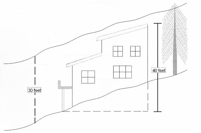
2. Structures employing the use of a cantilever may extend the cantilever a horizontal distance twice the height of the support. The maximum vertical height of the support shall be eight (8) feet. One-half (1/2) the area underneath the cantilevered element shall be calculated as disturbed area (see figure 4).
Figure 4 – Height for a Cantilevered Element
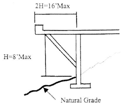
3. All of the setback requirements of the underlying zoning district shall apply in the Mountainside Development Area.
4. Material used for exterior surfaces such as structures, walls, roofs, and fences shall blend with the surrounding natural setting and avoid high contrasts. There shall be no paint or material colors used which have a LRV (Light Reflecting Value) greater than thirty-eight (38%) percent. Limited use of contrasting accent colors (in excess of 38% LRV) for small elements such as doors and window mullions may be allowed upon explicit approval of the Development Review Committee.
5. All electrical service equipment and sub-panels and all mechanical equipment including, but not limited to, air conditioning, evaporative cooling, and antennas greater than twenty four (24) inches in diameter shall not be allowed on the roof. All mechanical, electrical, and natural gas equipment along with antennas shall be screened in such a manner that they are not visible from outside the property when viewed from the same or a lower elevation. Solar panels may be allowed if they are integrated into the building design and approved by the Development Review Committee.
6. Mirrored surfaces or reflective treatment that changes or enhances ordinary glass into a mirrored surface is prohibited. Permanently reflective metallic surfaces shall be prohibited.
7. The building design should minimize the reflection of daytime glare from glass and the emission of light from within the structure during evening hours.
C. Land Disturbance Standards
1. The limits of construction and proposed disturbed areas shall be clearly staked in the field, with visible roping, prior to and during construction, and shall conform to the approved subdivision, or individual site plan. No disturbance shall be permitted beyond the areas designated as the limits of disturbance both during and after construction. If land disturbance in violation of this ordinance occurs, the illegally disturbed area(s) shall be restored to its natural grade and re-vegetated with plant material of the same species, size, and similar density prior to the illegal disturbance.
2. All disturbed land that is not otherwise used for approved development shall be restored to the natural grade and re-vegetated with natural plant material.
3. All buildings, structures, roads, and drives shall, to the fullest extent practicable, follow and utilize the natural contours of the land to minimize disturbance. The maximum height of any cut used to establish a building site shall not exceed thirty (30) feet.
4. All surplus excavated material shall be removed from the lot prior to the issuance of the Certificate of Occupancy.
5. After final grading, not more than five (5%) percent of the lot shall be steeper than the natural grade of the lot.
6. The total disturbance area shall not exceed the allowed percentage of the lot area as shown in Table 1 below.
7. Grading within street right-of-way or tracts of land for private roads is exempt from the disturbance calculations. Any roadway grading beyond the limits of the dedicated rights-of-way or private road tract shall be placed in slope easements and included within the calculations for land disturbance limitations.
8. A legally pre-existing disturbed area may be excluded from disturbed area calculations when the applicant has committed to comply with the following restoration conditions:
a. The restored area shall follow original natural contours.
b. The restoration shall be treated with an aging agent approved by the Town Engineer and planted with indigenous plant material.
c. The restoration process shall be approved, stamped and sealed by a landscape architect and/or a registered engineer or architect.
|
Average Lot Slope |
% Allowance Land Disturbance |
Building Site Slope |
% Allowed Land Disturbance |
|
15% |
45% |
45% |
18% |
|
20% |
40% |
50% |
16% |
|
25% |
35% |
55% |
15% |
|
30% |
30% |
60% |
14% |
|
35% |
25% |
65% |
13% |
|
40% |
20% |
70% |
12% |
|
|
|
75% |
10% |
D. Driveways
1. Driveways that serve a new single residence shall be: (1) a minimum of twelve (12) feet wide; (2) designed with an overall grade that does not exceed (a) twenty (20%) percent if longer than one hundred (100) feet or (b) twenty five (25%) percent if one hundred (100) feet or shorter; (3) constructed in full conformance with the requirements of the local Fire District; and (4) developed only as specifically approved by the Development Review Committee. The driveway shall be included in the calculations for land disturbance limitations.
2. Any street or driveway cut greater than eight (8) feet shall not have a length greater than one hundred (100) feet.
3. A twenty (20) foot by thirty (30) foot driveway apron may be required by the Fire Marshall or the Building Official at or near the garage, with no more than a five (5%) percent grade, to serve as a staging platform to fight a fire.
4. The maximum height, measured vertically, of any cut used to establish a street or driveway shall not exceed thirty (30) feet.
E. Grading And Drainage Standards
1. There shall be no clearing, grubbing, grading, importing or stockpiling of fill material on, or to, any site prior to approval of such Development by the Development Review Committee and approval of a grading plan by the Town Engineer, unless such clearing, grubbing, or grading, is required by the Town for public safety purposes.
2. The maximum depth of fill shall not exceed eight (8) feet except beneath the footprint of a main residence. All exposed disturbed area fill shall be contained behind retaining walls or covered with a natural rock veneer and treated with an aging agent and landscaped with indigenous plant material.
3. Rip-rap spill slopes may be allowed provided that they are approved by the Development Review Committee, and:
a. The vertical height of the spill slope does not exceed the vertical height of the exposed cut with the base of the spill slope engineered for stability and keyed into the mountain or supported by a retaining wall.
b. The spill slope does not exceed a two to one slope.
c. Retaining walls used to limit the height of the spill slope are color treated or veneered to blend in with the surrounding natural colors.
4. Raw spill slopes are prohibited. Any violation will be subject to a stop work order until the spill slope is removed, restored to its natural grade, re-vegetated, and approved by the Town.
5. A mountainside wash shall not be diverted, relocated, or moved from its present position to another location; however, a mountainside wash may be bridged by a structure so long as such structure does not impede the flow of the mountainside wash.
6. Earth contiguous to the structure shall contact that structure at an angle approximating that of the natural grade.
F. Walls And Fences
1. Curbs less than twelve (12) inches above finished grade are not considered walls.
2. No more than three hundred (300) total linear feet of wall shall be visible from any point on the property line.
3. Walls are prohibited in the Mountainside Development Area except as expressly approved by the Development Review Committee. Retaining walls, walls used to screen mechanical equipment and tennis/sport court fencing are allowed provided that they are of minimum lengths and heights, as further specified below, and are approved by the Development Review Committee.
a. Retaining Walls:
(1) The maximum length of any continuous retaining wall shall not be more than one hundred (100) linear feet. The maximum height of any retaining wall shall not be more than eight (8) feet. The height of a retaining wall is measured from the low side of natural grade when retaining fill slopes and from finished grade when retaining cut slopes to the top of the wall; whether the top is retaining earth or not.
(2) Retaining walls shall be used for the purpose of containing fill material or for minimizing cut or fill slopes. The retaining wall may only extend six (6) inches above the material it is retaining.
(3) A terraced combination of retaining walls shall be measured as a single retaining wall provided the combined walls are: (1) no more than eight (8) feet total vertical height; (2) terraced with a minimum distance between walls of four (4) feet and a maximum separation of eight (8) feet; and (3) contain appropriate vegetation between the walls so as to soften the visual impact of the combined walls (see figure 5).
(4) When a safety fence, on top of a retaining wall, is required by code it shall be a view fence and shall be painted to blend with surrounding natural colors.
(5) Where retaining walls are provided they shall be color treated, textured, or veneered to blend in with the surrounding natural colors and textures of the native rock and soils at the site.
b. Walls used to screen mechanical equipment: These walls may be solid walls provided they are of minimum height and length needed to screen the mechanical equipment and shall not exceed six (6) feet in height.
Figure 5 – Terraced Vertical Retaining Walls
G. Additions to Existing Structures:
1. The Development Review Committee may review applications for additions to existing structures if the Town Engineer in consultation with the Development Review Committee determines that the proposed addition: (i) increases the building height; or (ii) increases the existing building footprint by more than one thousand (1,000) square feet or more than fifty (50%) percent of the original building square footage; or (iii) creates an additional disturbance area; or (iv) creates a significant adverse visual impact.
2. If no new disturbance area is required and the addition meets all other mountainside requirements including allowable disturbed area, a permit for an addition to a mountainside building may be obtained without requirements for disturbed area calculations or any other specific requirements as determined by the Town Engineer.
3. Any proposed improvements to existing mountainside structures, which require additional disturbed area, shall be accompanied by calculations of prior disturbed area to determine if the entire site is within the allowed limits.
H. Sewers and Utilities
1. Grading for utility lines, including water and sewer lines and lateral lines, electric, gas, telephone and cable services, shall be included within the calculations for land disturbance limitations unless:
a. Trenches are placed under a driveway, under paving or in other areas already counted as disturbed, or
b. Trenches and related disturbed area are restored to appear as original ground, color treated and planted to blend with surrounding natural growth.
I. Fire Protection
1. The forest health and fire prevention ordinance (Chapter 17.96) shall be followed in its entirety.
17.04.080 Density and subdivision/lot split standards.
A. The maximum number of lots into which Mountainside Development Area land may be subdivided shall be the sum of the number of lots allowed in each slope category of land as shown by the following Table 2 Density/Slope Category.
B. Slope shall be calculated using a minimum of three (3) slope lines per acre. The slope lines shall be perpendicular to the slope and at equal distances across the lot.
C. Each of the resulting lots shall meet the minimum lot size requirements based upon the average lot slope shown on Table 2.
D. Building envelopes shall be conceptually indicated on preliminary plats and accurately shown on final plats.
E. The subdivider shall demonstrate by sketches, engineering drawings, charts or other means that roads, public or private, and driveway access and placement of residential structure will conform, for each lot, to current Mountainside Development Regulations and without the need for a variance.
F. All subdivision development and minor land division applications shall comply with the Mountainside Development Requirements in the Town of Pinetop-Lakeside Subdivision Ordinance. (Ord. 04-240)
|
Average Lot Slope – % |
Minimum Lot Size Square Feet |
Minimum Lot Size – Acres |
Average Lot Slope – % |
Minimum Lot Size – Square Feet |
Minimum Lot Size Acres |
|
15% |
12,500 |
0.29 |
45% |
43,560 |
1.0 |
|
20% |
15,000 |
0.34 |
50% |
57,9335 |
1.33 |
|
25% |
17,500 |
0.40 |
55% |
73,745 |
1.67 |
|
30% |
20,000 |
0.46 |
60% |
87,120 |
2.0 |
|
35% |
21,780 |
0.0 |
65% |
108,900 |
2.50 |
|
40% |
32,670 |
0.75 |
70% |
130,680 |
3.0 |
|
|
|
|
75% |
174,240 |
4.0 |