


Chapter 18.02
COASTAL ZONE DISTRICTS, USES, REGULATIONS, AND REQUIREMENTS
Sections:
18.02.030 Establishment and designation of coastal zoning districts.
18.02.040 Development requiring coastal development permit.
18.02.050 Allowed land uses and permit requirements for coastal zoning districts.
18.02.060 Site development standards.
18.02.070 Special development standards.
18.02.010 Purpose.
The purpose of this chapter is to establish the zoning districts and related components of the implementation plan, including all zoning uses, regulations and requirements consistent with the policies and provisions in the land use plan (LUP), applicable to all areas within the city of Seaside coastal zone. (Ord. 1006 § 4 (Att. 1), 2013)
18.02.020 Compliance.
All properties within the coastal zone shall be subject to compliance with applicable regulations herein. Specifically, the following rules shall apply to property within designated coastal zoning districts:
A. No structure shall be erected and no existing structure shall be moved, altered, added to, or enlarged, nor shall any land, structure, or premises be used, designated, or intended to be used for any purpose, or in any manner other than is included among the uses hereinafter listed as permitted in the district in which such structure, land, or premises is located.
B. No structure shall be erected, reconstructed, or structurally altered to exceed in height the limit hereinafter designated for the district in which such structure is located.
C. No structure shall be erected, altered, enlarged, or rebuilt, except in conformity to the setback, building site area, structure location, and other applicable regulations hereinafter designated for the district in which such structure is located.
D. No use shall be established, expanded, altered, changed, or otherwise modified except as provided for in the terms of this title. (Ord. 1006 § 4 (Att. 1), 2013)
18.02.030 Establishment and designation of coastal zoning districts.
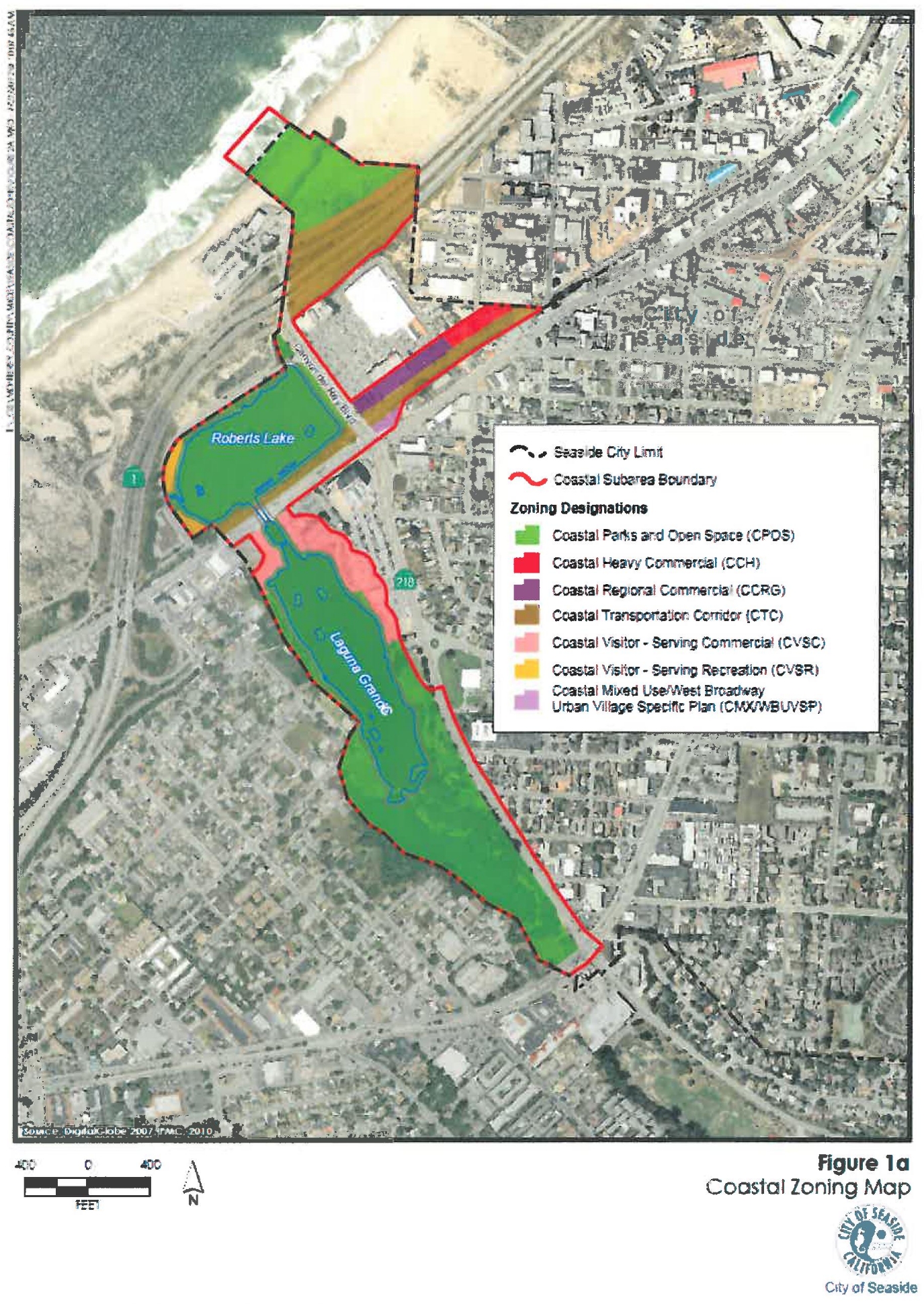
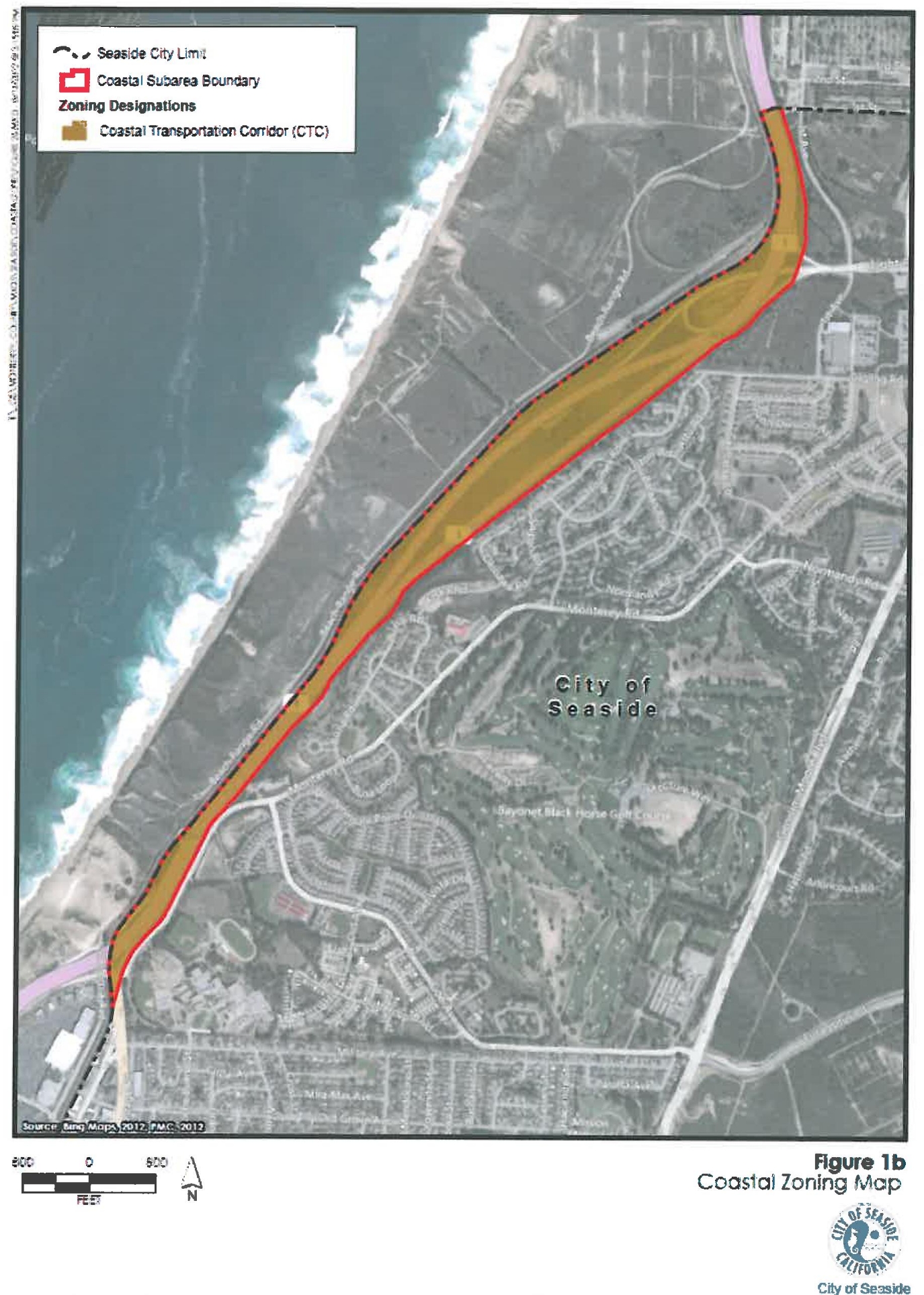
A. Establishment of Coastal Zoning Districts. The city of Seaside coastal zone is hereby divided into seven coastal zoning districts as shown below in Table 1.
|
Coastal Zoning Symbol |
Coastal Zone District Name |
Purpose |
|---|---|---|
|
CPOS |
Coastal Parks and Open Space |
To protect and preserve coastal resources, including sensitive habitats, public views, and other visual amenities, and public recreational access opportunities, within the coastal zone. This zone is also applied to existing or planned coastal parkland. Public use areas include sandy beaches, accessways, parks, trails, walkways, and other recreational amenities that are publicly owned or over which easements have been established, including where they are required as a condition of development. |
|
CVSC |
Coastal Visitor-Serving Commercial |
To establish areas to service the needs of visitors to Seaside and the surrounding area. |
|
CVSR |
Coastal Visitor-Serving Recreation |
To establish areas to service the recreational needs of visitors to Seaside and the surrounding area. |
|
CMX/WBUVSP |
Coastal Mixed Use/West Broadway Urban Village Specific Plan |
To promote pedestrian- and transit-oriented activity centers that have a mix of residential, commercial, office, and civic uses. This designation is appropriate in a portion of the Del Monte subarea consistent and compatible with the West Broadway Urban Village specific plan. The city may consider identification and development of transit parking or supporting uses as a component of this designation within the coastal zone. This designation is intended to accommodate an active mixed-use corridor along Del Monte Boulevard as identified in the West Broadway Urban Village specific plan. |
|
CCRG |
Coastal Regional Commercial |
To establish areas with existing regional commercial uses that provide employment-generating opportunities for the community. |
|
CCH |
Coastal Heavy Commercial |
To establish areas with existing heavy commercial uses (i.e., automotive repair shops, contractor yards, light manufacturing, utility substations, and warehousing). |
|
CTC |
Coastal Transportation Corridor |
To accommodate motorized and nonmotorized forms of transportation. |
B. Designation of Coastal Zoning Districts. The designations, locations, and boundaries of districts are set forth on the city of Seaside coastal zoning map, originally dated April 28, 2010. The city of Seaside coastal zoning map is on file with the city clerk and is illustrated in Figures 1a and 1b. This map may be amended by ordinance of the planning commission subject to certification by the California Coastal Commission.
(Ord. 1006 § 4 (Att. 1), 2013)
18.02.040 Development requiring coastal development permit.
All development as it is defined in Chapter 18.04 SMC requires a coastal permit (i.e., a coastal administrative permit or a coastal development permit). The following types of development require a coastal development permit (and may not be approved via a coastal administrative permit) in accordance with the provisions of Chapter 18.03 SMC regardless of which coastal zoning district or category of allowed uses it falls into:
A. Development which is deemed to have the potential to cause a significant environmental impact pursuant to the California Environmental Quality Act (CEQA).
B. Development within a visual resource area as identified on Figure 2-4, Views and Viewsheds to Visual Resources, of the LUP.
C. Development within one hundred feet of mapped or field-identified wetlands or environmentally sensitive habitat areas (ESHA).
D. Development within seven hundred fifty feet of a known archaeological resource as identified through an archaeological survey report.
E. Development within a natural hazard area as defined in Chapter 18.04 SMC or on soils with a high or very high erosion hazard potential, according to the Soil Conservation Service Soil Survey Manual. (Ord. 1006 § 4 (Att. 1), 2013)
18.02.050 Allowed land uses and permit requirements for coastal zoning districts.
A. Except as otherwise provided in this title, persons wishing to undertake any development in the coastal zone shall obtain either: a coastal administrative permit (CAP) for development associated with principal allowable uses that: (1) as proposed is consistent with the LCP; (2) requires no discretionary approval other than a coastal permit; and (3) has no adverse effect either individually or cumulatively on coastal resources, including public access; or a coastal development permit (CDP) for development associated with conditional allowable uses or any other use/development not meeting the criteria for a CAP, in accordance with the provisions of this title.
B. Table 2, below, summarizes the uses allowed in the coastal zoning districts and identifies where such uses are principally permitted (P), conditionally permitted (UP), or not allowed (–) in compliance with this title.
|
Land Use (1) |
Permit Requirements by Zoning District (2, 3) |
||||||
|---|---|---|---|---|---|---|---|
|
CPOS |
CVSC |
CVSR |
CMX/WBUVSP(4) |
CCRG |
CCH |
CTC |
|
|
Agriculture, Resource and Open Space |
|||||||
|
Ecological restoration activities |
P |
P |
P |
P |
UP |
UP |
P |
|
Habitat management |
P |
P |
P |
P |
UP |
UP |
P |
|
Nature preserve |
P |
P |
P |
P |
UP |
UP |
P |
|
Public use recreation |
P |
P |
P |
P |
UP |
UP |
P |
|
Industry, Manufacturing and Processing, Wholesaling |
|||||||
|
Manufacturing/processing – light |
– |
– |
– |
– |
– |
P |
– |
|
Research and development |
– |
– |
– |
– |
UP |
P |
– |
|
Laboratory – analysis, research and development, testing |
– |
– |
– |
– |
– |
P |
– |
|
Storage |
– |
– |
– |
– |
– |
UP |
– |
|
Recreation, Education and Public Assembly |
|||||||
|
Boating and related facilities (structures such as boathouses and launches) |
P |
P |
P |
– |
– |
– |
– |
|
Biking and related facilities (structures such as bike racks and lockers) |
P |
P |
P |
P |
– |
– |
P |
|
Conference/convention facility |
– |
UP |
– |
UP |
– |
– |
P |
|
Library, museum, art gallery |
UP |
– |
– |
UP |
P |
– |
– |
|
Sports and entertainment assembly |
UP |
– |
– |
UP |
UP |
– |
– |
|
Interpretive center/environmental education activities |
P |
P |
P |
UP |
UP |
UP |
P |
|
Carnivals, festivals, races not lasting more than three days and not involving permanent facilities |
UP |
UP |
UP |
UP |
– |
– |
– |
|
Meeting facility, public or private |
UP |
UP |
– |
UP |
– |
– |
– |
|
Health/fitness facility |
– |
– |
UP |
– |
P |
– |
– |
|
Picnic area |
P |
P |
P |
P |
UP |
UP |
UP |
|
Park, playground |
P |
P |
P |
P |
UP |
UP |
UP |
|
Bike trail |
P |
P |
P |
P |
P |
P |
P |
|
Light rail |
– |
UP |
UP |
P |
P |
P |
P |
|
Pedestrian path |
P |
P |
P |
P |
P |
P |
P |
|
Retail |
|||||||
|
Coastal recreational equipment rental |
UP |
P |
P |
– |
– |
– |
UP |
|
Furniture, furnishings, and appliance store |
– |
– |
– |
P |
P |
P |
– |
|
Shopping center |
– |
– |
– |
P |
P |
– |
– |
|
General retail – 5,000 SF or larger |
– |
– |
– |
P |
P |
– |
– |
|
General retail – less than 5,000 SF |
– |
– |
– |
P |
P |
P |
– |
|
Outdoor retail sales and activities |
– |
UP |
UP |
P |
UP |
P |
– |
|
Restaurant, cafe – coffee shop – table service |
– |
P |
– |
P |
UP |
– |
UP |
|
Restaurant, cafe – counter service such as a snack bar ancillary to a primary use |
UP |
P |
UP |
P |
– |
– |
UP |
|
Restaurant, cafe – fast food |
– |
UP |
– |
P |
UP |
– |
– |
|
Restaurant, cafe – drive-through |
– |
UP |
– |
– |
– |
– |
– |
|
Winery/wine tasting |
– |
UP |
– |
UP |
– |
– |
– |
|
Services |
|||||||
|
Lodging – hotel, motel, or inn |
– |
P |
– |
UP |
– |
– |
– |
|
Kennel, animal boarding |
– |
– |
– |
– |
– |
UP |
– |
|
Visitor/traveler support services |
– |
P |
P |
P |
– |
– |
P |
|
Catering service |
– |
– |
– |
– |
UP |
P |
– |
|
Service stations |
– |
P |
– |
– |
– |
– |
– |
|
Maintenance service |
– |
– |
– |
– |
– |
P |
– |
|
Vehicle repair |
– |
– |
– |
– |
UP |
P |
– |
|
Vehicle storage |
– |
– |
– |
– |
– |
UP |
UP |
|
Accessory Structures |
|||||||
|
Accessory structures and accessory uses appurtenant to any principal allowed use provided there is no intensification of the permitted use |
P |
P |
P |
P |
– |
– |
P |
|
Accessory structures and uses prior to establishment of allowed main use or structure |
– |
UP |
– |
UP |
– |
– |
UP |
|
Minimum accessory facilities, such as restrooms, parking accessory to other principal permitted uses |
P |
P |
P |
P |
P |
P |
UP |
Notes:
(1) Refer to Chapter 18.04 SMC, Definitions, for land use definitions.
(2) See Table 1 for district name and purpose.
(3) Additional permits (such as building permits) may be required.
(4) Refer to the applicable development standards and design guidelines for the West Broadway Urban Village specific plan for specific land uses and permit requirements (LCP Appendix C).
P Principal (permitted) use allowed, coastal administrative permit or coastal development permit required (refer to Chapter 18.03 SMC) unless exempt.
UP Conditional use allowed, coastal development permit required (refer to Chapter 18.03 SMC) unless exempt.
– Use not allowed.
(Ord. 1006 § 4 (Att. 1), 2013)
18.02.060 Site development standards.
The following development standards apply to all property within the coastal zoning districts as outlined in Table 3 below. Please refer to SMC 18.02.070 for additional special development standards that may apply.
|
Development Standard (1, 6) |
ZONING DISTRICT (2) |
||||||
|---|---|---|---|---|---|---|---|
|
CPOS |
CVSC |
CVSR |
CCRG |
CCH |
CMX/WBUVSP (3) |
CTC (5) |
|
|
Maximum structure height (except where lower heights are necessary to protect public views) (4, 7) |
24 ft. |
Lesser of five stories or 60 feet |
24 ft. |
25 ft. |
25 ft. |
See the applicable development standards and design guidelines for the West Broadway Urban Village specific plan (LCP Appendix C) |
To be determined at time of development in a manner designed to protect coastal resources, and subject to coordination with the California Department of Transportation (Caltrans), transportation agency of Monterey County (TAMC), and/or Southern Pacific Railroad Standards, as applicable |
|
Minimum setbacks |
|
|
|
|
|
||
|
Front |
30 ft. |
See SMC 18.02.070, Special Development Standards (4) |
None |
10 ft. |
|||
|
Side – interior |
30 ft. |
10 ft. |
None |
||||
|
Side – street side |
30 ft. |
None |
None |
||||
|
Rear |
30 ft. |
None |
None |
||||
|
Maximum building site coverage |
10% |
90% |
50% |
90% |
90% |
||
|
Minimum lot area |
|
1 acre |
0.5 acres |
20,000 SF |
12,000 SF |
||
|
Minimum lot width |
|
300 ft. |
80 ft. |
100 ft. |
100 ft. |
||
|
Minimum lot depth |
|
500 ft. |
125 ft. |
N/A |
N/A |
||
|
Parking requirements |
See SMC 18.02.060(A), Parking Requirements |
|
|
||||
|
Landscaping requirements |
See SMC 18.02.060(B), Landscaping Requirements |
|
|
||||
|
Lighting requirements |
See SMC 18.02.060(C), Lighting Requirements. See also SMC 18.02.070, Special development standards, for additional requirements |
|
|
||||
|
Sign requirements |
See SMC 18.02.060(D), Sign Requirements |
|
|
||||
|
Floor area ratio (FAR) |
0.01:1 |
1.0:1 |
0.5:1 |
1.0:1 |
0.5:1 |
|
|
|
Special regulations for hotels/motels (only applicable to CVSC): Maximum hotel/motel density: 1.5:1 FAR Hotels/motels parking: 1 space per guestroom; plus 2 for every 50 rooms; plus parking as required for accessory uses |
|||||||
Notes:
(1) Refer to Chapter 18.04 SMC, Definitions, for definitions.
(2) See Table 1 for district name and purpose.
(3) Refer to the applicable development standards and design guidelines for the West Broadway Urban Village specific plan for specific land uses and permit requirements (LCP Appendix C).
(4) LUP Figure 2-4, Views and Viewsheds to Visual Resources, of the LUP shall be used to assist the city in identifying significant pubic views of natural features within the coastal zone to identify viewshed enhancement areas and identify sensitive areas where height and bulk limits shall be required.
(5) State Highway 1 right-of-way is owned by Caltrans. Railroad right-of-way is owned by Southern Pacific Railroad. Bike path improvements may be subject to TAMC requirements.
(6) The identified site development standards represent maximum and minimum thresholds for compliance, and not entitlements to those exact dimensions. Depending on actual site constraints, standards that are less than the maximum or more than the minimum standards may be required to ensure adequate coastal resource protection (e.g., a structure may be required to be limited to a lesser height than the maximum allowed height to adequately protect public views).
(7) Refer to SMC 18.02.070 for special development standards for each subarea.
A. Parking Requirements.
1. General Parking Requirements. These requirements are intended to ensure that suitable off-street parking and loading facilities are provided for all uses and developments, and that the facilities are properly designed, attractive, and located to be unobtrusive while meeting the needs of the specific use. Each land use and structure, including a change or expansion of a land use or structure, shall provide suitable off-street parking and loading facilities. A land use shall not be commenced and a structure shall not be occupied until the parking and loading improvements required by this chapter are completed and approved.
a. Parking and Loading Spaces to Be Permanent. Each parking and loading space shall be permanently available, marked, and maintained for parking or loading purposes for the use it is intended to serve; provided, that the approval of a limited term permit may allow the temporary use of a parking or loading space for other purposes.
i. Subdivision of Property. No subdivision shall be approved that has the effect of reducing existing on-site parking below the minimum number of spaces required by this chapter.
ii. Lot Restriping. A parking lot shall not be restriped to reduce the number of parking spaces below the minimum required by this chapter.
b. Parking and Loading to be Unrestricted. A lessee, owner, tenant, or other person having control of the operation of a premises for which parking or loading spaces are required by this chapter shall not prevent, prohibit, or restrict authorized persons from using the spaces without the prior approval of the zoning administrator.
c. Vehicles for Sale. No vehicle, trailer, or other personal property shall be parked on private property for the purpose of displaying the vehicle, trailer, or other personal property for hire, rental, or sale, unless the applicable zone allows the use, and the person or business at that location is licensed to sell vehicles, trailers, or other personal property.
d. Recreational Vehicle (RV) Parking.
i. The storage (parking for any period longer than seventy-two hours) of a recreational vehicle (RV) and/or boat in a residential zone shall be allowed only when all portions of the vehicle or boat are located entirely within the property boundaries and do not extend into the public right-of-way.
ii. Parking within setback areas shall also comply with setback requirements and exceptions – limitations on the use of setbacks.
e. Cargo Containers. No shipping container (e.g., metal “Seatrain” or other similar cargo container) shall be stored within a designated parking space or loading area.
2. Number of Parking Spaces Required. Each land use shall be provided the number of off-street parking spaces required.
a. Parking Requirements by Land Use.
i. Each land use shall provide the number of off-street parking spaces required by Table 4, except where a greater number of spaces is authorized through minor use permit or use permit approval.
ii. A land use not specifically listed in Table 4 shall provide parking as required by the zoning administrator. The zoning administrator shall use the requirements in Table 4 as a guide in determining the appropriate number of off-street parking spaces required for the use.
iii. In any case where Table 4 expresses a parking requirement based on floor area in square feet (for example: one space for each one thousand sf), “sf” means square feet of gross interior leaseable floor area, unless stated otherwise (e.g., ground area).
iv. A single use with accessory components shall provide parking for each component. For example, a hotel with a gift shop shall provide the parking spaces required by Table 4 for a hotel (e.g., the guest rooms), and for a gift shop.
|
Land Use Type |
Vehicle Spaces Required |
|---|---|
|
Manufacturing Processing and Warehousing Land Uses |
|
|
All manufacturing, industrial, and processing uses, except the following: |
1 space for each 200 sf of office area; |
|
|
1 space for each 500 sf of floor and/or ground area devoted to other than office use; |
|
|
1 space for each 5,000 sf of open storage. |
|
Media production |
1 space for each 300 sf. |
|
Recycling facilities: |
|
|
Heavy or light processing facilities |
Determined by use permit. |
|
Large collection facilities |
Determined by use permit. |
|
Scrap/dismantling yards |
1 space for each 300 sf, plus 1 space for each 10,000 sf of gross yard area. |
|
Small collection facilities |
Determined by minor use permit. |
|
Wholesaling and distribution |
1 space for each 500 sf. |
|
Recreation, Education, and Public Assembly |
|
|
Clubs, community centers, lodges, and meeting halls |
1 space for each 4 fixed seats or 1 space for each 100 sf where there are no fixed seats. |
|
Commercial recreation facilities – Indoor, except for the following: |
1 space for each 400 sf. |
|
Arcades |
1 space for each 200 sf. |
|
Bowling alleys |
4 spaces for each alley. |
|
Pool and billiard rooms |
2 spaces for each table. |
|
Commercial recreation facilities – outdoor |
Determined by use permit. |
|
Conference/convention and sports/entertainment facilities |
1 space for each 200 sf. |
|
Retail and Service Commercial |
|
|
In an effort to simplify the calculation of parking demand and to anticipate future tenants, the list of nonresidential (e.g., retail and service commercial) off-street parking requirements shall be broken down into the following four distinct categories based on the anticipated level of parking demands. See also the parking requirements for other specific retail and service uses on the following page. |
|
|
Group One: Uses with “low parking demand.” Examples include appliance, carpet, fabric, furniture, and tile stores; book, card, and stationary stores; camera, dry cleaning and laundry, flower, gift, glass, hardware, heating and electrical, jewelry, paint, pet, plumbing, wallpaper stores; home improvement stores; photography studios, print shops; supermarkets; and other retail and light industrial uses determined to be similar by the zoning administrator. |
1 space for each 500 sf or less, with a minimum requirement of 4 spaces. |
|
Group Two: Uses with “medium parking demand.” Examples include bakeries, banks, barber shops, beauty shops, business and professional offices, convenience stores, department stores, donut and ice cream shops, liquor stores, secondhand stores, and other retail uses determined to be similar by the zoning administrator. |
1 space for each 300 sf or less, with a minimum requirement of 5 spaces. |
|
Group Three: Uses with “high parking demand.” Examples include bars, coffee houses, dental and medical offices and clinics, health clubs, laundromats, restaurants and other intense uses determined to be similar by the zoning administrator. |
1 space for each 200 sf. |
|
Group Four: Uses with “unique parking demands.” Examples include auto repair, auto sales, contractor’s yards, funeral homes, gas stations, hotels and motels, large day care facilities (e.g., child care and seniors), large group homes, mini-warehouse, self-service car wash, theaters, and other uses determined to be similar by the zoning administrator. |
|
|
Auto and vehicle repair/service |
4 spaces for each service or wash bay, plus spaces for any office as required by this section for offices. |
|
Auto and vehicle sales and rental |
1 space for each 400 sf of floor area for the showroom and offices, plus 1 space for each 2,000 sf of outdoor display area, plus spaces as required by this section for parts sales and vehicle repair/service. |
|
Contractor’s storage yards |
1 space for each 3,000 sf of lot area, plus spaces for any office as required by this section for offices. |
|
Gas stations without repair services |
0.25 space for each gas pump, plus 2 spaces for each gasoline pump island, plus spaces as required by this section for convenience goods sales. |
|
Lodging – hotels and motels |
1 space for each unit, plus 2 spaces for the manager or owner, plus required spaces for all accessory uses (e.g., conference center, restaurant, spa, or other recreational facilities). |
|
Personal storage (mini-warehouses) |
4 spaces for the manager’s office. |
|
Restaurant |
1 space for each 3 seats. |
|
Self-service car washes |
1 space for each wash bay. |
|
Theaters (e.g., movie) |
1 space for each 4 seats or 1 space for each 100 sf, whichever would yield more spaces. |
b. Expansion of Structure, Change in Use. When a structure is enlarged, or when a change in its use requires more off-street parking than the previous use, additional parking spaces shall be provided in compliance with this chapter.
c. Multi-Tenant Sites.
i. A site with multiple tenants (e.g., two or more) shall provide the aggregate number of parking spaces required for each separate use (e.g., sum of the separate requirements for each use), except where the site is developed as an integrated shopping center with shared parking and no spaces reserved for a particular use. In this instance, the parking shall be provided as required by Table 4 for a shopping center.
ii. When a multi-tenant center includes one or more uses that will need more parking than retail uses (e.g., a health/fitness facility, restaurant, or theater) additional parking shall be required for the nonretail use unless a parking reduction is approved in compliance with reduction of parking requirements, below.
d. Alternate Use of Parking Areas Prohibited. Off-street parking areas shall not be used for the repair, servicing, or storage of vehicles or materials, the sale of any goods or services, or any other work area.
e. Recreational Vehicle (RV) Parking Spaces. Off-street recreational vehicle (RV) parking spaces shall be provided as follows for retail uses, shopping centers, and visitor attractions that are required by this chapter to provide forty or more off-street parking spaces.
i. RV parking spaces shall be provided at a minimum ratio of one RV space for each forty off-street vehicle parking spaces, or fraction thereof, required by this chapter.
ii. Each RV parking space shall be designed as a pull-through space with a minimum width of twelve feet and a minimum length of forty feet, with fourteen feet of vertical clearance.
f. Rounding of Calculations. If a fractional number is obtained in calculations performed in compliance with this chapter, one additional parking space shall be required for a fractional unit of one-half or above, and no additional space shall be required for a fractional unit of less than one-half.
g. Estimating Spaces. Where fixed seating is provided as benches, bleachers, pews, or similar seating, a seat shall be defined as twenty-four inches of bench space for the purpose of calculating the number of parking spaces required by Table 4. Whenever parking requirements are based on the number of employees, calculations shall be based on the largest number of employees on duty at any one time.
h. Nonconforming Parking. A use or structure with nonconforming off-street parking may be physically changed or undergo a change in use in compliance with the following provisions:
i. The number of existing parking spaces shall be maintained on the site and additional parking shall be provided in compliance with this chapter for any additional floor area.
ii. If the use of the structure is changed to one that requires more parking than the previous use, only the difference between the number of parking spaces required for the previous use and those required for the new use shall be added.
iii. The change shall not eliminate the only portion of the site that can be used for the required or existing parking or access.
i. Reduction of Parking Requirements. No off-street parking facility shall be reduced in capacity or in area without sufficient additional capacity or additional area being provided in order to comply with the parking regulations unless they meet the following requirements:
i. Shared On-Site Parking. Where two or more adjacent nonresidential uses have distinct and differing peak parking usage periods (e.g., a theater and a bank), a reduction in the required number of parking spaces may be allowed through use permit approval. Approval shall also require a recorded covenant running with the land, recorded by the owner of the parking lot, guaranteeing that the required parking will be maintained exclusively for the use served for the duration of the use.
ii. Reduction of Required Parking. The number of parking spaces may be reduced through the granting of a minor use permit based on quantitative information provided by the applicant that documents the need for fewer spaces (e.g., sales receipts, documentation of customer frequency, information on parking standards required for the proposed land use by other cities, etc.).
j. Waiver of Requirements. The parking requirements of this chapter may be waived through use permit approval when a nonconforming structure is proposed for rehabilitation if the planning commission first finds that the existing structure location, parcel size, or topography renders the requirement unreasonable.
3. Additional Parking Provisions.
a. Disabled Parking Requirements. Each nonresidential development shall provide the following number of parking spaces for the disabled: One parking space for the disabled shall be provided within a parking lot with less than twenty-five spaces; and larger parking lots (e.g., with twenty-five or more spaces) shall include additional spaces for the disabled as required by state or federal law. Parking spaces required for the disabled shall count toward compliance with the minimum number of off-street parking spaces required by this chapter.
Each parking space for the disabled shall have a minimum width of fourteen feet. All spaces for the disabled shall be located so that: The spaces provide easy access from the closest parking area to the major entrances of the use for which they are provided; the disabled individual is not compelled to wheel or walk behind parked cars other than his or her own; and a pedestrian way accessible to physically disabled persons shall be provided from each parking space to related facilities including curb cuts and/or ramps.
b. Bicycle Parking Requirements. Each multifamily project and nonresidential land use shall provide bicycle parking. A multifamily project shall provide bicycle parking spaces equal to a minimum of ten percent of the required vehicle spaces, unless separate secured garage space is provided for each unit. The bicycle spaces shall be distributed throughout the project. A nonresidential project (e.g., office, retail, etc.) shall provide bicycle parking spaces equal to a minimum of five percent of the required vehicle spaces, distributed to serve customers and employees of the project.
Each bicycle parking space shall include a stationary parking device to adequately secure the bicycle, shall be a minimum of two feet in width and six feet in length, with a minimum of seven feet of overhead clearance, and shall be conveniently located and generally within proximity to the main entrance of a structure.
c. Motorcycle Parking Requirements. A parking lot with fifty or more vehicle parking spaces shall provide motorcycle parking spaces conveniently located near the main entrance to the primary structure and accessed by the same access aisles that serve the vehicle parking spaces in the parking lot. A minimum of one motorcycle parking space shall be provided for each fifty vehicle spaces or fraction thereof. Motorcycle spaces shall have minimum dimensions of four feet by seven feet.
d. Public Access Parking. Public access parking and related facilities shall be provided at and/or adjacent to all identified beach, park, and open space areas commensurate with demand for such facilities and the need to provide post-construction water quality measures including low impact design (LID) strategies identified in the water quality section in SMC 18.02.070(G)(5)(b).
4. Parking Design and Development Standards. Required parking areas shall be designed, constructed, and properly maintained in compliance with the following requirements:
a. Parking Lots Access and Circulation. Parking areas shall provide suitable maneuvering area so that vehicles enter from and exit to a public street in a forward direction only. Parking lots shall be designed to prevent access at any point other than at designated access drives. Multifamily dwelling units are exempt from this requirement, unless specifically required by conditions of a discretionary permit. This requirement does not apply to alleys, unless so specified in a specific zone. A nonresidential development that provides fifty or more parking spaces shall have access driveways that are not intersected by a parking aisle, parking space, or another access driveway for a minimum distance of twenty feet from the street right-of-way, to provide a queuing or stacking area for vehicles entering and exiting the parking area. A minimum unobstructed clearance height of fourteen feet shall be maintained above areas accessible to vehicles within nonresidential developments.
b. Location of Parking. Parking shall be located on the same parcel as the uses served or within three hundred feet of the parcel if shared parking or public parking facilities are used to meet parking requirements. A greater distance may be authorized by the commission through use permit approval. Parking may be located within a required side or rear setback; provided, that it is separated from the side or rear property line by a minimum five-foot wide landscaped area.
c. Parking Lot Access on Adjacent Sites. Developments are encouraged to provide on-site vehicle access to parking areas on adjacent properties to provide for convenience, safety and efficient circulation. A joint access agreement running with the land shall be recorded by the owners of the abutting properties guaranteeing the continued availability of the shared access between the properties.
d. Parking Stall and Lot Dimensions. The standard parking shall be a minimum of nine feet wide and nineteen feet long. However, depending on the stall orientation and angle the length and depth of the stall may vary as shown in Table 5.
|
Stall Orientation |
Stall Width |
Stall Depth (Measures Perpendicular to Aisle) |
Stall Length |
Aisle Width |
|
|---|---|---|---|---|---|
|
One-Way |
Two-Way |
||||
|
Standard Parking Stalls |
|||||
|
Parallel |
9' |
9' |
22' |
12' |
24' |
|
30° |
9' |
18' |
20' |
12' |
N/A |
|
45° |
9' |
20' 6" |
20' |
14' |
N/A |
|
60° |
9' |
22' |
20' |
18' |
N/A |
|
Perpendicular |
9' |
19' |
19' |
24' |
24' |
|
Compact Parking Stalls |
|||||
|
Parallel |
8' |
8' |
18' |
12' |
24' |
|
30° |
8' |
15' 6" |
16' |
12' |
N/A |
|
45° |
8' |
17' |
16' |
14' |
N/A |
|
60° |
8' |
18' |
16' |
18' |
N/A |
|
Perpendicular |
8' |
16' |
16' |
24' |
24' |
e. Use of Compact Vehicle Spaces. The first ten spaces of any project shall be standard sized spaces. In multifamily residential projects, up to thirty percent of the required uncovered parking spaces may be compact spaces (eight feet wide by sixteen feet wide). For nonresidential projects, up to thirty percent of the required parking spaces may be compact spaces. Compact spaces shall be clearly labeled for “compact cars” and grouped together in one or more locations or at regular intervals so that only compact vehicles can easily maneuver into the space.
f. Proper Grading, Surfacing and Maintenance of Parking Lots Required. All grading plans relating to the parking facilities shall be reviewed and approved by the city engineer before any work can commence. All off-street parking facilities shall be properly graded and drained so as to dispose of all surface water accumulated within the area of the parking lot. In no instance shall a storm drainage facility be designed to allow the flow of water into abutting property. All parking spaces and maneuvering areas shall be properly surfaced with two inches of asphaltic concrete over a five-inch aggregate base, or comparable material as determined by the city engineer.
g. Vehicle Overhanging Landscaped Area or Walkway Prohibited. The required length of a parking space shall not provide for a vehicle overhanging a landscaped area or walkway.
h. Water Quality Requirement. Post-construction best management practices (BMPs) and water quality mitigation measures such as site design and source control BMPs, including low impact development (LID) techniques, shall be incorporated into all parking and loading facilities projects to minimize impacts from storm water runoff and dry weather flows (see SMC 18.02.070(G)(5)(b)).
5. Driveways and Site Access. Each driveway providing site access from a street, alley, or other public right-of-way shall be designed, constructed, and properly maintained in compliance with the following:
a. Number of Driveways. The number and placement of driveways shall be limited as follows; provided, that second driveways or additional curb cuts may be approved by the traffic advisory committee. A multifamily or nonresidential development project on a parcel of two acres or less shall be limited to a maximum of two driveways, unless the city engineer determines that more than two driveways are required to accommodate the traffic for the project. Whenever a property has access to more than one street, access shall be generally limited to the lowest volume street where the impact of a new access will be minimized.
b. Distance from Street Corners and Spacing. Each driveway shall be separated from the nearest street intersection as follows, except where the city engineer allows less separation: a minimum of one hundred fifty feet from the nearest intersection, as measured from the centerline of the driveway to the centerline of the nearest travel lane of the intersecting street. For parcels with frontages less than one hundred fifty feet, the minimum distance shall be one hundred feet. Where two or more driveways serve the same or adjacent multifamily or nonresidential development, the centerline of the driveways shall be separated by a minimum of fifty feet. The city engineer may approve exceptions to this standard.
c. Driveway Dimensions. A driveway for a multifamily or nonresidential development shall have a minimum paved width of thirteen feet for a one-way driveway and twenty-six feet for a two-way driveway. The maximum driveway width shall be thirty-five feet, exclusive of any area provided for a median divider. Where unpaved driveways are otherwise allowed by this title or the review authority, each driveway shall be paved with concrete or asphalt for a minimum length of twenty feet from the public right-of-way.
d. Clearance. The nearest edge of a driveway curb cut shall be at least three feet from the nearest property line, the centerline of a fire hydrant, light standard, traffic signal, utility pole or other similar facility. Street trees shall be a minimum of ten feet from the driveway access, measured at the trunk. A driveway shall have an overhead clearance of fourteen feet in height except within a parking structure, which may be reduced to seven feet, six inches.
6. Loading Space Requirements. Off-street loading spaces shall be provided, unless determined by the city that the operating, shipping, and delivery characteristics of the use do not require the number or type of loading spaces required. Nonresidential uses shall provide off-street loading spaces as follows:
|
Floor area under 15,000 square feet |
None required; except grocery store greater than 5,000 square feet requires 1 space |
|
Floor area 15,000 to 50,000 square feet |
1 space |
|
Floor area over 50,000 square feet |
2 spaces |
a. Loading Space Types. Loading docks instead of loading spaces shall be required at big box stores, home improvement centers, and large shopping centers. Loading spaces, rather than loading docks, shall be required for convenience stores, offices, restaurants, small shopping centers where truck deliveries occur on a regular basis, but where a loading dock is not necessary.
b. Development Standards. Loading spaces shall be a minimum of twelve feet in width, forty feet in length, with fourteen feet of vertical clearance. Loading areas shall have lighting capable of providing adequate illumination for security and safety.
c. Location. Loading spaces shall be as near as possible to the main structure and limited to the rear two-thirds of the parcel, if feasible; situated to ensure that the loading facility is screened from adjacent streets; situated to ensure that loading and unloading takes place on site and in no case faces a public street, or is located within a required front or street side setback, adjacent public right-of-way, or other on-site traffic circulation areas; and situated to ensure that all vehicular maneuvers occur on site. The loading areas shall allow vehicles to enter from and exit to a public street in a forward motion only. Loading areas shall avoid adverse impacts upon neighboring residential properties. The review authority may restrict times allowed for loading and deliveries for loading spaces that are located closer than one hundred feet to a residential zone.
d. Screening. Loading areas shall be screened from abutting parcels and streets with a combination of dense landscaping and solid masonry walls with a minimum height of six feet.
e. Striping. Loading spaces shall be striped, and identified for “loading only.” The striping and “loading only” notations shall be continuously maintained in a clear and visible manner in compliance with the approved plans.
f. Surfacing. All loading areas shall be surfaced with asphalt, concrete pavement, or comparable material as determined by the city engineer.
B. Landscaping Requirements.
1. General Landscaping Requirements. For purposes of this section, “landscaping” shall mean the placement of materials (e.g., berms, decorative fences and walls, flowers, grass, groundcover, hedges, shrubs and trees) within a designated area.
a. To conserve water, the installation of native and/or drought-tolerant landscape materials is strongly encouraged.
b. All parts of a site not devoted to decks, patios, structures, and similar improvements, driveway and/or parking improvements, lighting, sidewalks, signs, and solid waste/recyclable materials collection and storage shall be landscaped in compliance with this section and this title.
c. Within coastal strand vegetation areas, undeveloped dune areas, steep dunes, and steep slope areas (those in excess of twenty-five percent slope) shall be landscaped with native, noninvasive plant species to maximize opportunities for native habitat restoration.
d. A master restoration plan shall be prepared by a qualified professional for any undeveloped private dune areas, as well as all public dune areas situated within the coastal zone.
e. Where feasible and practical, landscaping shall be designed to address post-construction water quality site design and low impact design (LID) requirements (e.g., as biofiltration, vegetated swales, or similar) and to minimize adverse impacts from storm water runoff and dry weather flows.
2. Landscaping of Parking Lots. Parking lots shall be landscaped as follows:
a. Amount of Landscaping. Multifamily, commercial, and industrial uses shall provide landscaping within each outdoor parking area at a minimum ratio of ten percent of the gross area of the parking lot. The board of architectural review may grant an exception for small, infill parking lots where compliance with this standard is not feasible without significantly reducing the number of parking spaces. Trees not less than five feet in height and fifteen-gallon container in size shall be planted throughout the parcel and along any street frontage. At a minimum, one shade tree shall be provided for every five parking spaces.
b. Landscape Materials. Landscaping shall be provided throughout the parking lot as a combination of groundcover, shrubs, and trees.
c. Location of Landscaping. Landscaping shall be evenly dispersed throughout the parking area, as follows:
i. Orchard-style planting (the placement of trees in uniformly spaced rows) is encouraged for larger parking areas;
ii. Parking lots with more than fifty spaces shall provide a concentration of landscape elements at primary entrances, including, at a minimum, specimen trees, flowering plants, enhanced paving, and project identification;
iii. Landscaping shall be located so that pedestrians are not required to cross unpaved landscaped areas to reach building entrances from parked cars. This shall be achieved through proper orientation of the landscaped fingers and islands, and by providing pedestrian access through landscaped areas that would otherwise block direct pedestrian routes.
d. Perimeter Landscaping. All surface parking areas shall be screened from streets and adjoining properties, and the open areas between the property line and the public street right-of-way shall be landscaped. A parking area for a nonresidential use adjoining a public street shall be designed to provide a landscaped planting strip between the street right-of-way and parking area equal in depth to the setback required by the applicable zone or ten feet, whichever is greater; except that the required width of the landscape strip may be reduced by the board of architectural review (BAR) upon recommendation from the city’s park supervisor, where it has been determined that the overall site area is insufficient to accommodate allowable structures and required parking along with a landscape strip of the otherwise required width.
i. The landscaping shall be designed and maintained to screen cars from view from the street to a minimum height of thirty-six inches, but shall not exceed any applicable height limit for landscaping within a setback. Screening materials may include a combination of plant materials, earth berms, raised planters, solid decorative masonry walls, or other screening devices which meet the intent of this requirement.
ii. Shade trees shall be provided at a minimum rate of one for every twenty-five linear feet of landscaped area, or other spacing as determined by the review authority to be appropriate to the site and surrounding development.
iii. Parking areas for nonresidential uses shall provide a perimeter landscape strip at least eight feet wide (inside dimension) where the parking area adjoins a side or rear property line; except that the required width of the landscape strip may be reduced by the review authority where it determines that overall site area is insufficient to accommodate allowable structures and required parking along with a landscape strip of the otherwise required width. The requirement for a landscape strip may be satisfied by a setback or buffer area that is otherwise required. Trees shall be provided at the rate of one for each twenty-five linear feet of landscaped area, or other spacing as determined by the review authority to be appropriate to the site and surrounding development.
iv. Adjacent to Structures. When a parking area is located adjacent to a nonresidential structure, a minimum eight-foot-wide (inside dimension) landscape strip shall be provided adjacent to the structure, exclusive of any building entries, or areas immediately adjacent to the wall of the structure that serve as pedestrian accessways. The required width of the landscape strip may be reduced by the review authority where it determines that overall site area is insufficient to accommodate allowable structures and required parking along with a landscape strip of the otherwise required width.
v. Adjacent to Residential Use. A parking area for a nonresidential use adjoining a residential use shall provide a landscaped buffer setback with a minimum ten-foot width between the parking area and the common property line bordering the residential use.
(A) A solid decorative masonry wall or fence, except for approved pedestrian access, and landscape buffer shall be provided along the property line to address land use compatibility issues (e.g., light/glare and nuisance noise) as determined by the review authority.
(B) Trees shall be provided at the rate of one for each twenty-five linear feet of landscaped area, or other spacing as determined by the review authority to be appropriate to the site and surrounding development
e. Groundwater Recharge. The design of parking lot landscape areas shall consider and may, where appropriate, be required to include provisions for the on-site detention of storm water runoff, pollutant cleansing and groundwater recharge.
3. Landscaping Standards.
a. Minimum Dimensions. Each area of landscaping shall have a minimum interior width of eight feet within the residential and commercial zones, and five feet in the industrial zones. These dimensions may be reduced where the review authority determines they are infeasible because of limited site area. Wherever this title requires a landscaped area of a specified width, the width shall be measured within any curb or wall bordering the landscaping area.
b. Protective Curbing. Required landscaping shall be protected with a minimum six-inch high concrete curb, except adjacent to bicycle paths, or where otherwise deemed unnecessary by the zoning administrator.
c. Safety Requirements. Landscape materials shall be located so that at maturity they do not:
i. Interfere with safe sight distances for bicycle, pedestrian or vehicular traffic;
ii. Conflict with overhead lights, utility lines or walkway lights; or
iii. Block bicycle or pedestrian ways.
d. Lawns. Lawns shall be limited to fifty percent of the total landscaped area on the site and only where the applicant provides calculations approved by the zoning administrator that demonstrate that the irrigation requirements will not exceed standard low water usage. No lawns shall be allowed:
i. In any area of ten feet or less in width; or
ii. On any slope exceeding ten percent (twenty-five percent, where other project water-saving techniques compensate for the increased runoff). A level buffer zone of eighteen inches shall be provided between bermed lawn areas and any hardscape (e.g., any street, walkway or similar feature); or
iii. A nonrecreational land use.
e. Water Features. Decorative water features (e.g., fountains, ponds, waterfalls) shall have recirculating water systems.
4. Visual Obstructions.
a. When placed within or immediately adjacent to a dedicated public right-of-way, no landscape material shall be allowed to obstruct clear vision or to create a potential traffic hazard.
b. Landscaping that is primarily intended or designed for fencing purposes shall not be allowed to exceed four feet in height within a required front setback area.
c. On the street sides of a corner parcel, no landscaping shall be allowed to exceed four feet in height above the top of the existing or proposed street curb within the traffic safety visibility area.
5. Trees.
a. In order to achieve a more immediate effect, all trees planted on the street sides of a newly developed parcel shall be transplanted from five-gallon or larger size containers. A tree proposed to replace an existing mature specimen tree shall be transplanted from a minimum twenty-four-gallon size container.
b. All trees shall be adequately supported when planted. The supports shall be maintained until the trees are capable of withstanding the force of wind on their own.
c. Where existing trees are required to be preserved, all new development shall be designed in a manner which respects the current drip lines.
6. Solar Access. When trees are incorporated into an approved landscaping plan, they shall be planted in a manner which maximizes the provision of sunlight to nearby windows and/or solar collectors situated on site or on an adjoining property.
7. Irrigation System Requirements. All landscaped areas except those approved for maintenance with intentionally nonirrigated native plants shall include an automatic irrigation system.
a. Water-efficient systems (e.g., bubbler-type, drip, mini-spray, or similar system) shall be used unless infeasible. Low-flow sprinkler heads with matched precipitation rates shall be used when spray or rotor-type heads are specified for watering shrubs and groundcover areas. Lawn areas shall be sized and shaped so they can be efficiently irrigated. Spray or runoff onto paved areas shall be avoided.
b. Dual or multi-program controllers with separated valves and circuits shall be used when the project contains more than one type of landscape treatment (e.g., groundcover, lawn, shrub, tree areas), or a variety of solar aspects. Soil moisture-sensing devices and rain sensors shall be used on larger projects (fifty thousand plus square feet of landscaped area) to minimize or eliminate over-watering.
c. Watering shall be scheduled at times of minimal wind conflict and evaporation loss.
d. Sprinkler heads shall have matched precipitation rates within each valve zone.
e. Check valves are required where elevation differential may cause low head drainage.
8. Responsibility of the Board of Architectural Review.
a. The board of architectural review (BAR) shall be primarily responsible for the review and approval of landscape plans and improvements within the city.
b. All new construction shall receive prior approval of all landscape plans from the board of architectural review (BAR).
9. Statement of Surety. When required by the city, security in the form of cash, performance bond, letter of credit, or instrument of credit, in an amount equal to one hundred fifty percent of the total value of all plant materials, irrigation, installation, and maintenance shall be posted with the city for a two-year period. The city may require statements of surety for phased development projects, a legitimate delay in landscape installation due to seasonal requirements (including adverse weather conditions) and similar circumstances where it may not be advisable or desirable to install all approved landscaping before occupancy of the site.
a. Installation and Inspection Before Occupancy. All landscaping shall be installed and inspected by a representative of the department before the city will allow occupancy of any structure or authorize the issuance of a certificate of occupancy.
10. Maintenance of Landscape Areas. All landscaping (e.g., groundcover, hedges, lawns, shrubs, and trees) shall be maintained in a healthful and thriving condition at all times. Irrigation systems and their components shall be maintained in a fully functional manner consistent with the originally approved design and the provisions of this section.
a. Regular maintenance shall include checking, adjusting, and repairing irrigation equipment; resetting automatic controllers; aerating and dethatching lawn areas; adding/replenishing mulch, fertilizer, and soil amendments; and mowing, pruning, trimming, and watering all landscaped areas. In addition, the landscaping shall regularly be kept free of weeds and debris, and all dead or decaying material shall be replaced in a timely manner. All fences and walls which have been incorporated into an approved landscaping plan shall regularly be maintained in an attractive and safe manner.
b. Maintenance Agreement Required. Before final inspection or occupancy, and before the recordation of a final subdivision map where applicable, the applicant shall enter into a landscape maintenance agreement with the city to guarantee proper maintenance in compliance with subsection (B)(10)(a) of this section. The form and content of the agreement shall be approved by the city attorney and the zoning administrator.
c. Water Waste Prohibited. Water waste in existing developments resulting from inefficient landscape irrigation leading to excessive runoff, low head drainage, overspray, and other similar conditions where water flows onto adjacent property, nonirrigated areas, walks, roadways or structures is prohibited.
d. Enforcement. Failure to maintain landscape areas in compliance with this section shall be deemed a public nuisance, and shall be subject to abatement, and/or the applicable planning permit may be revoked.
C. Lighting Requirements. Outdoor lighting on the site of a multifamily or nonresidential structure or use shall comply with the following general requirements:
1. Lighting General Requirements.
a. Maximum Height. An outdoor light fixture shall be limited to a maximum height of fourteen feet or the height of the nearest structure, whichever is less.
b. Energy Efficiency. Outdoor lighting shall utilize energy-efficient (high pressure sodium, low pressure sodium, hard-wired compact fluorescent, or other lighting technology that is of equal or greater energy efficiency) fixtures and lamps.
c. Position of Light Fixtures. All lighting fixtures shall be properly directed, recessed, and/or shielded (e.g., downward and away from adjoining properties) to prevent light bleed, spill, and glare onto adjacent properties, wetlands or natural habitat areas, beach, or public rights-of-way, by:
i. Ensuring that the light source (e.g., bulb, etc.) is not visible from off the site; and
ii. Confining glare and reflections within the boundaries of the subject site to the maximum extent feasible.
d. Maximum Illumination. No lighting on private property shall produce an illumination level greater than one foot-candle on any property within a residential zone except on the site of the light source.
e. No Blinking, Flashing or High Intensity. No permanently installed lighting shall blink, flash, or be of unusually high intensity or brightness, as determined by the city.
f. New Light Fixtures on Commercial Buildings. Installation of new light fixtures on commercial buildings shall be subject to review and approval by the city.
D. Sign Requirements.
1. Sign Permit Requirements.
a. Sign Permit Required. No sign shall be constructed, installed, or modified, unless a sign permit is first obtained from the city. Any sign visible from the general viewing points identified on Figure 2-4 of the LUP must obtain a coastal permit. No sign permit shall be approved for an existing or proposed sign unless the sign is in compliance with all applicable requirements. A building permit may also be required for sign construction/installation.
b. Master Sign Program Required. A master sign program approved by the board of architectural review (BAR) shall be required for any site with two or more tenants. As part of master sign program approval, the BAR may grant exceptions to the standards of this chapter for the maximum size and number of signs, based on design features including architectural style, proportion to landscaping, site visibility and building mass.
c. Review Authority. The board of architectural review shall review each sign permit application and approve only those that comply with the following findings of approval:
i. The proposed signs do not exceed the standards of zoning district sign standards and standards for specific sign types below and are of the minimum size and height necessary to enable pedestrians and motorists to readily identify the facility or site from a sufficient distance to safely and conveniently access the facility or site;
ii. The placement of the sign on the site is appropriate for the height and area of a freestanding or projecting sign;
iii. A flush or projecting sign relates to the architectural design of the structure. Signs that cover windows, or that spill over natural boundaries, and/or cover architectural features shall be prohibited;
iv. The proposed signs do not unreasonably block the sight lines of existing signs on adjacent properties;
v. The placement and size of the sign will not impair pedestrian or vehicular safety;
vi. The design, height, location, and size of the signs are visually complementary and compatible with the scale and architectural style of the primary structures on the site, any prominent natural features on the site, and structures and prominent natural features on adjacent properties on the same street;
vii. The proposed signs will not block, interrupt, or otherwise degrade the scenic and visual quality to and along the ocean and scenic coastal areas as identified on Figure 2-4 of the LUP; and
viii. The proposed signs are in substantial conformance with the design criteria for signs.
d. Application Requirements. An application for a sign permit shall be filed and processed. The application shall be accompanied by detailed and fully dimensioned plans, architectural drawings and sketches, and data/materials identified in the department handout for sign permits, and any applicable fees.
e. Expiration and Extension of Sign Permit Approval. Approval of a sign permit shall expire twelve months from the date of approval unless the sign has been installed, or a different expiration date is stipulated at the time of approval. Before the expiration of a sign permit, the applicant may apply to the department for an extension of up to an additional twelve months from the original date of expiration. The expiration date of the sign permit shall be automatically extended to concur with the expiration date of the companion building permit or other applicable permits for the project.
f. Exemptions from Sign Permit Requirements. The following signs are allowed without sign permit approval; provided, they comply with general requirements for all signs, and any required building permit is obtained:
i. Nonstructural Modifications and Maintenance.
(A) Modifications to sign copy on conforming signs, or changes to the face or copy of conforming changeable copy signs; and
(B) The normal maintenance of conforming signs, except as identified in subsection (D)(2)(h) of this section, Maintenance of Signs.
ii. Identification Signs. Street identification and house identification signs not exceeding two square feet.
iii. Temporary Signs. The following temporary signs are allowed without a sign permit:
(A) Real Estate Signs. Real estate signs are allowed without a sign permit in compliance with California Civil Code Section 713, and properties within commercial, industrial, and other nonresidential zones shall be allowed one real estate sign of no more than sixteen square feet, with a maximum height for freestanding signs of six feet, for each parcel frontage.
(B) Political Signs. Political signs are allowed in compliance with the following requirements:
(1) Before the placement of a political sign, the agent/candidate shall post with the city clerk a plan for the removal of all signs placed in commercial and industrial zones and removal of all signs placed by the candidate or the agent in residential zones. In the event that the signs are not removed in compliance with the plan for removal, the city shall provide notice and summary abatement. The removal plan shall also apply to signs located at campaign or party headquarters.
(2) No political sign shall be erected prior to sixty days before the election to which the sign pertains.
(3) In commercial and industrial zones, each political sign and the total political signs on a parcel shall not exceed thirty-two square feet in area.
(4) In residential zones, no political sign shall exceed six square feet in area.
(5) No political sign shall be located within a public right-of-way.
(6) All political signs shall be removed within ten days after the election to which the signs pertain.
iv. Governmental Signs. Signs installed by the city, county, or a federal or state governmental agency, because of their responsibilities for the protection of public health, safety, and general welfare, including the following signs:
(A) Emergency and warning signs necessary for public safety or civil defense;
(B) Traffic signs erected and maintained by an authorized public agency;
(C) Legal notices, licenses, permits, and other signs required to be displayed by law;
(D) Signs showing the location of public facilities (e.g., public telephones, restrooms, and underground utilities); and
(E) Any sign, posting, notice, or similar sign placed by or required by a governmental agency in carrying out its responsibility to protect public health, safety and general welfare.
v. Miscellaneous Signs.
(A) Address numbers not exceeding twelve inches in height.
(B) Official Flags on Public or Quasi-Public Buildings. Flags of national, state, or local governments, or nationally recognized religious, fraternal, or public service agencies; provided, the length of the flag shall not exceed one-fourth the height of the flag pole, and the flag is not used for commercial advertising.
(C) Illumination, patterns, pictures, and/or symbols approved as architectural ornamentation or decoration by the review authority.
(D) Historical plaques erected and maintained by nonprofit organizations, memorials, building cornerstones, and date-constructed stones; provided, that none of these exceed four square feet in area.
(E) Service station price signs required by state law, not exceeding the number and area required by state law.
(F) Signs or displays located entirely inside of a structure.
(G) Signs created by landscaping.
(H) Small, temporary signs, otherwise in conformance with the duration, number, and size requirements of this chapter, that address noncommercial issues.
g. Prohibited Signs. All signs not expressly allowed by this chapter shall be prohibited. Examples of prohibited signs include the following:
i. Abandoned signs;
ii. Animated signs, including electronic message display signs, and variable intensity, blinking, or flashing signs, or signs that emit a varying intensity of light or color, except time and temperature displays (which are not considered signs);
iii. Balloons and other inflatable devices;
iv. Billboards and any other off-premise signs;
v. Flags, except as specifically allowed by subsection (D)(1)(f)(v)(B) of this section, official flags;
vi. Illegal signs;
vii. Moving signs, and other similar signs that are stationary but contain moving parts;
viii. Obscene signs;
ix. Pennants and streamers, except in conjunction with an athletic event, carnival, circus, or fair, or as allowed in subsection (D)(4)(e) of this section, Temporary Signs;
x. Pole signs and other freestanding signs over six feet in height;
xi. Roof signs;
xii. Because of the city’s compelling interest in ensuring traffic safety, signs that simulate in color, size, or design any traffic control sign or signal, or that make use of characters, symbols, or words in a manner that interferes with, misleads, or confuses pedestrian or vehicular traffic;
xiii. Signs in the form or shape of a directional arrow, or otherwise displaying a directional arrow, except as may be approved by the review authority, or as may be required for safety and convenience and for control of pedestrian or vehicular traffic within the premises of the subject use;
xiv. Signs attached to or suspended from a boat, float, vehicle, or other movable objects parked within a public right-of-way, or in a location on private property that is visible from a public right-of-way, except a sign painted directly upon, magnetically affixed to, or permanently affixed to the body or other integral part of the vehicle;
xv. Signs burned, cut, or otherwise marked on or otherwise affixed to a hillside or tree;
xvi. Signs with reflective material;
xvii. Signs within the public right-of-way, except for signs installed or maintained by a government agency for traffic safety and directional purposes;
xviii. Signs in residential zones, except as specifically allowed in this chapter;
xix. Signs in storage or in the process of assembly or repair, located outside on premises other than that advertised in the signs, that are visible from a public right-of-way; and
xxi. Temporary and portable signs, except as specifically allowed by subsection (D)(4)(e) of this section, Temporary Signs.
2. Sign General Requirements for All Signs. The following rules shall govern the computation of sign area:
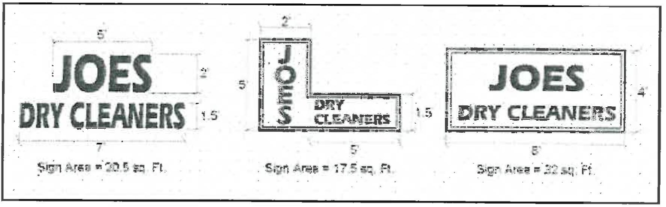
a. Sign Area Measurement. Sign area measurement to determine compliance with the sign area limitations of this chapter shall occur as follows:
i. Surface Area. The surface area of a sign shall be calculated by enclosing the extreme limits of all emblem, framing, logo, representation, writing, or other display within a single continuous perimeter composed of squares or rectangles with no more than eight perimeter lines.
ii. Sign Structure. Supporting bracing or framework that is determined by the zoning administrator to be clearly incidental to the display itself shall not be included in the calculation of total sign area.
iii. Multi-Faced Signs. The area of a double-faced sign shall be calculated for one face only, unless the two faces are not back to back, parallel, and/or are separated by more than twelve inches.
iv. Three-Dimensional Objects. The area of a sign consisting of one or more three-dimensional objects (e.g., balls, cubes, clusters of objects, sculpture, or statue-like trademarks) shall be measured as their maximum projection upon a vertical plane.
b. Sign Height.
i. Measurement. The height of a sign shall be computed as the vertical distance from the lowest point of the base of the sign at normal grade to the top of the highest attached component of the sign. Normal grade shall be construed to be the lower of either the:
(A) Existing grade before construction; or
(B) Newly established grade after construction, exclusive of any berming, filling, mounding, or excavating solely for the purpose of locating the sign.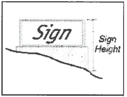
ii. Maximum Height for Freestanding Signs. A freestanding sign shall not exceed a height of six feet above normal grade in the residential zones. Freestanding signs shall be limited to fourteen feet above normal grade in all other zones.
iii. Maximum Height for Signs on Structures. The top of a sign mounted on a structure shall not extend higher than the lesser of:
(A) The window sills of the second floor;
(B) The top of the wall to which the sign is attached, in the case of a one-story structure; or
(C) Twenty feet above normal grade.
c. Sign Location Requirements. Each sign shall be located in compliance with the following requirements, and all other applicable provisions of this chapter:
i. Each sign shall be located on the same site as the subject of the sign, except as otherwise allowed by this chapter.
ii. No sign shall project over public property, or the public right-of-way, except where the city has granted an encroachment permit in addition to a sign permit.
iii. No sign shall be placed so as to interfere with the operation of a door, fire escape or window.
d. Signs Placed within the Public Right-of-Way.
i. No sign shall be allowed within the public right-of-way except for the following:
(A) Public signs erected by or on behalf of a governmental agency to convey public information, identify public property, post legal notices, or direct or regulate pedestrian or vehicular traffic;
(B) Bus stop signs installed by a public transit company;
(C) Informational signs of a public utility regarding its lines, pipes, poles or other facilities; or
(D) Emergency warning signs erected by a governmental agency, a public utility company, or a contractor doing authorized work within the public right-of-way.
ii. Any sign installed or placed within the public right-of-way other than in compliance with this section shall be forfeited to the public and be subject to confiscation.
iii. In addition, the city shall have the right to recover from the owner, or person placing the sign, the full costs for sign removal and disposal.
iv. A sign permit shall not be required for city signs placed within the public right-of-way.
e. Design Criteria. The following design criteria shall be used in reviewing the design of individual signs. Substantial conformance with each of the following design criteria shall be required before a sign permit or building permit can be approved:
i. Color. Colors on signs and structural members should be harmonious with one another and relate to the dominant colors of the other structures on the site. Contrasting colors may be utilized if the overall effect of the sign is still compatible with the structure colors and prevailing colors in the surrounding neighborhood (where a theme can be identified).
ii. Design and Construction. The intent of this subsection is to ensure public safety, achieve signs of careful construction, neat and readable copy, and durability, to reduce maintenance costs and to prevent dilapidation. Each sign shall be designed by a professional (e.g., architect, building designer, landscape architect, interior designer, or another whose principal business is the design, manufacture, or sale of signs), or others who are capable of producing professional results. Each permanent sign should be constructed by persons whose principal business is building construction or a related trade including sign manufacturing and installation businesses, or others capable of producing professional results.
iii. Materials and Structure. Sign materials (including framing and supports) shall be representative of the type and scale of materials used on the primary on-site structure and on other on-site signs. Materials for permanent signs shall be durable and capable of withstanding weathering over the life of the sign with reasonable maintenance. The size of the structural members (e.g., braces, columns, and crossbeams) shall be proportional to the sign panel they are supporting. In general, fewer larger supporting members are preferable to many smaller supports. The use of individual letters incorporated into the structure’s design is encouraged, rather than signs with background and framing other than the structure’s wall(s).
iv. Street Address. The review authority may require that a sign include the site street address, where it determines that public safety and emergency vehicle response would be more effectively served than if the street address were displayed solely on one or more structures on the site.
f. Copy Design Guidelines. The city does not regulate the message content (copy) of signs; however, the following are principles of copy design and layout that can enhance the readability and attractiveness of signs. Copy design and layout consistent with these principles is encouraged.
i. Sign copy should relate only to the name and/or nature of the business or commercial center.
ii. Permanent signs that advertise continuous sales, special prices, or include phone numbers, etc. should be avoided.
iii. Information should be conveyed briefly or by logo, symbol, or other graphic manner. The intent should be to increase the readability of the sign and thereby enhance the identity of the business.
iv. The area of letters or symbols should not exceed forty percent of the background area in commercial and industrial zones or sixty percent in residential zones.
v. Freestanding signs should contain the street address of the parcel or the range of addresses for a multi-tenant center.
g. Sign Lighting. Sign lighting shall be designed to minimize light and glare on surrounding rights-of-way and properties in compliance with subsection C of this section, outdoor lighting, and the following:
i. External light sources shall be directed and shielded so they do not produce glare on any object other than the sign, and/or off the site of the sign;
ii. The light illuminating a sign shall not be of a brightness or intensity that will interfere with the reasonable enjoyment of residential properties;
iii. Sign illumination shall not blink, flash, flutter, or change light brightness, color or intensity;
iv. Colored lights shall not be used at a location or in a manner so as to be confused or construed as traffic control devices;
v. Neither the direct nor reflected light from primary light sources shall create hazards for pedestrians or operators of motor vehicles;
vi. Reflective-type bulbs and incandescent lamps that exceed fifteen watts shall not be used so as to expose the face of the bulb or lamp to a public right-of-way or adjacent property;
vii. Light sources shall utilize hard-wired fluorescent or compact fluorescent lamps, or other lighting technology that is of equal or greater energy efficiency;
viii. Permanently installed illuminated panels, visible tubing, and strings of lights outlining all or a portion of a structure, other than lighting that is primarily for indirectly illuminating architectural features, signs, or landscaping, shall be deemed “signs” subject to this chapter and shall be counted as part of the allowed sign area. Each line of tubing or lights shall be deemed to have a minimum width of at least six inches for the purpose of calculating area.
h. Maintenance of Signs.
i. Each sign and supporting hardware, including temporary signs, shall be maintained in good repair and functioning properly at all times.
ii. Any repair to a sign shall be of equal or better in quality of materials and design as the original sign.
iii. A sign that is not properly maintained and is dilapidated shall be deemed a public nuisance, and may be abated.
iv. When an existing sign is removed or replaced, all brackets, poles, and other supports that are no longer required shall be removed.
v. Unpainted areas shall be painted to match the adjacent portion of the structure or the sign support structure.
3. Sign Requirements for Commercial Land Uses. The sign requirements shall be applicable to the CMX/WBUVSP, CVSC, CCH and CCRG land uses within the coastal zone. Allowed signs and sign standards for these land uses are summarized in Table 6, in addition to the provisions of requirements for all signs above and standards for specific sign types below, as applicable.
|
Allowed Sign Types |
Maximum Sign Height |
Maximum Number of Signs Allowed per Parcel |
Maximum Sign Area Allowed per Parcel |
|---|---|---|---|
|
Ground-Mounted and Ground Floor Signs |
|||
|
Awning, Projecting, Wall |
Below roof (1) |
• Single tenant site or structure: 3 of any combination of allowed sign types per primary structure frontage. • 1 of any allowed sign type on a secondary frontage. • Site or structure with 4 or more tenants: 1 of any allowed sign type for the primary structure frontage, and 1 for a secondary frontage. |
• Maximum Sign Area per Parcel. The total sign area on a parcel shall comply with the following requirements: • 1.0 sf for each linear foot of primary building frontage. • 0.5 additional sf for each linear foot of secondary building frontage. • Each site is allowed a total sign area of at least 25 sf regardless of frontage length. • Maximum Sign Area per Building Frontage. The total area of all signs on a primary frontage shall not exceed 100 sf; the maximum area of a sign on a secondary frontage shall not exceed 50 sf. • Site with 4 or more tenants: Allowed an additional freestanding identification sign of 0.25 sf for each linear foot of total primary structure frontage, up to a maximum of 100 sf. |
|
Freestanding
Suspended |
14 ft
Below eave/canopy; at least 8 ft above a walking surface |
||
|
Second Floor Signs |
|||
|
Awning, Projecting, Wall |
Below roof (1) |
1 per tenant space |
12 sf for each tenant. 1 directory sign not to exceed 12 sf is also allowed to identify upper floor occupants. |
|
Indoor Signs, and Outdoor Signs Not Visible from a Street |
|||
|
Awning, Freestanding, Projecting, Suspended, Wall, Window |
Below roof (1) |
|
|
Notes:
(1) At least one foot below the top of a parapet, the sill of a second floor window, and/or the lowest point of any cornice or roof overhang.
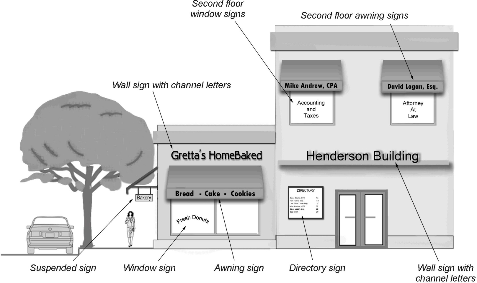
Examples of Sign Types
4. Standards by Sign Type. Proposed signs shall comply with the following standards applicable to the specific sign type:
a. Awning Signs. Awning signs are allowed within commercial land uses but must be at least one foot below the top of a parapet, the sill of a second floor window, and/or the lowest point of any cornice or roof overhang. Each tenant space may have one twelve-square-foot awning. Three of any combination of allowed sign types is the maximum allowed per primary structure frontage. The following standards apply to awning signs:
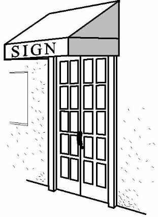
i. Signs on awnings are limited to ground level or second story occupancies only.
ii. Awnings shall not be internally illuminated. Direct exterior lighting may allowed.
iii. Translucent awning materials are prohibited.
b. Freestanding Signs. Freestanding signs are allowed within the commercial land uses to a maximum height of fourteen feet. The following standards apply to freestanding signs:
i. Multiple signs shall be separated by a minimum of seventy-five feet to ensure adequate visibility for all signs. The review authority may modify this requirement where the locations of existing signs on adjacent properties would make the seventy-five-foot separation impractical.
ii. A sign shall not project over public property, vehicular easements, or rights-of-way, and shall not obstruct a traffic safety sight area, as determined by the review authority.
iii. To assist emergency response personnel in locating the site, freestanding signs shall contain an illuminated street address plate. Numbers shall be a minimum of six inches in height. Street address numbers not exceeding twelve inches in height shall not be included in calculations of allowed sign area.
c. Murals. A mural placed on the wall of a structure may be allowed in any commercial or industrial zone subject to the following:
i. A mural without text visible from a public right-of-way shall be counted as part of the sign area allowed by sign standards allowed for that land use; a mural with text shall comply with the sign area limitations applicable to the site;
ii. Murals that illustrate the local setting and history as sources of inspiration are encouraged;
iii. The approval of a mural shall require that the review authority first find that the colors, placement, and size of the mural are visually compatible with the structure’s architecture, and that the mural will serve to enhance the aesthetics of the city.
d. Projecting Signs. Projecting signs are allowed within commercial land uses. The following standards apply to projecting signs where allowed:
i. The maximum projection of a sign from a structure wall shall not exceed eight feet or more than two-thirds of the width of the public sidewalk below. Any projection over a public right-of-way shall require an encroachment permit.
ii. The top of a projecting sign shall not exceed the lesser of fourteen feet, eave height, parapet height, or sill height of a second floor window. No portion of the sign shall project above the eave line of a sloped roof or the top of the parapet on a flat roof.
iii. A projecting sign shall maintain a minimum clearance of eight feet from the bottom of the sign to the finished grade below.
iv. Icon signs using shapes or symbols uniquely suited to the business, creative shapes, and three-dimensional signs are encouraged.
v. Each sign shall be graphically designed for pedestrians, with a maximum area of eight square feet on each sign face, regardless of the length of the building frontage.
vi. Sign supports shall be well-designed and compatible with the design of the sign.
e. Temporary Signs. Temporary signs other than A-boards are allowed subject to the following requirements. A-board signs are instead subject to the requirements of subsection D of this section.
i. Banners and Pennants. Temporary banners and pennants on private property shall comply with the following requirements:
(A) The use of a banner or pennants may be allowed only for a licensed business for a period not to exceed thirty days per year. A temporary sign permit may be issued for not less than two consecutive days, up to thirty days. A business is only allowed one temporary sign permit for banners or pennants per year. This is in addition to the thirty days allowed for a business grand opening banner;
(B) The application for a temporary sign permit for banners or pennants shall include the dates proposed by the applicant for scheduled banner use;
(C) A bond shall be posted for a banner permit as required by the zoning administrator. The bond may be revoked if the temporary banner or pennants are not removed within two days following their scheduled use.
ii. Construction Signs. Construction identification signs may be allowed in all zones in compliance with the following standards:
(A) The number, placement, size, and type of signs shall comply with the sign requirements for that land use.
(B) The signs shall be removed before final building inspection or the issuance of a certificate of occupancy.
iii. Other Temporary Signs. Temporary signs may be authorized by the city, upon submittal of a sign application, plan for removal, and the fees required by the city’s fee schedule. In a commercial or industrial zone, the combined area of temporary signs shall not exceed that allowed for the non-corner lots in the zone in which the sign will be placed. No more than one temporary sign shall be erected on a premises at a time. Temporary signs shall be subject to the same placement and height restrictions as permanent signs for the applicable land use. Temporary signs shall not be allowed for more than thirty consecutive days. Temporary signs shall not be allowed for a combined total of more than sixty days in a twelve-month period. Signs advertising a particular event shall be removed within ten days after the event. Inflatable or tethered signs are allowed for special events and may be installed for a period not to exceed five consecutive days, no more than two times in a twelve-month period. These signs may exceed the maximum sign area and sign height standards for the applicable zone.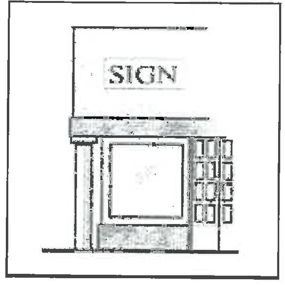
f. Wall Signs. Wall signs are allowed within commercial land uses. The following standards apply to wall signs in all zones where allowed:
i. One wall sign may be located on a primary structure frontage, and on one secondary structure frontage.
ii. The area of the largest wall sign shall not exceed ten percent of the area of the building facade on which the sign is mounted or painted, including the area of windows, doors and recesses.
iii. A wall sign shall not project more than twelve inches from the surface to which it is attached.
g. Window Signs. Windows signs are allowed within commercial land uses. The following standards apply to permanent window signs where allowed:
i. Maximum Sign Area. Permanent window signs shall not occupy more than twenty-five percent of the total window area.
ii. Sign Location. Signs shall be allowed only on windows located on the ground level and second story of a structure frontage.
iii. Sign Materials. Signs shall consist of individual letters, logos, or symbols applied to, stenciled on, or etched into the glass surface; however, neon signs with transparent backgrounds may be hung inside the window glass.
iv. Unobstructed Observation. The lowermost portion of the entire window(s) (a minimum of twenty-four inches) shall be clear of any signs in order to allow for unobstructed observation by security personnel (e.g., city police, private security, etc.).
h. Nonconforming Signs. A nonconforming sign is any permanent or temporary sign that was legally established and maintained in compliance with the provisions of all applicable laws in effect at the time of original installation but that does not now comply with the provisions of this title. A nonconforming sign shall not be: changed to another nonconforming sign; structurally altered to extend its useful life; enlarged; reestablished after a business is discontinued for thirty days; reestablished after damage or destruction to fifty percent or more of the value of the sign, or its components, as determined by the city’s building director; or reinstalled after facade improvements that required the removal of the sign during construction. Any interruption in the use of a nonconforming sign(s) that continues for sixty days or more shall be deemed to be an abandonment of the sign(s). Subsequent use shall comply with the regulations of this chapter. Nonoccupation or nonoperation of the building or business advertised on the sign shall be deemed an interruption of the use of the sign(s).
5. Public Nuisance, Abatement and Violation.
a. Signs on Vacated Buildings. Signs on premises that have been vacated for sixty days or more, and signs on multi-tenant buildings advertising a business that has been vacated for sixty days or more, shall be immediately removed by the owner after the expiration of that period. The city may issue a notice to remove the signs after the expiration of the sixty-day period. The notice to remove shall specify a fifteen-day period during which the signs shall be removed. If the owner does not remove the signs during the fifteen-day period, the city may have the sign removed at costs borne by the city. The city will bill the property owner for all costs related to removal and storage. Costs not paid to the city shall be recovered.
b. Violation, Abatement and Penalties. Any sign within the city that fails to comply with the requirements of this chapter, other applicable state statutes or city ordinances, or for which a sign permit has not been obtained in compliance with this chapter, shall be subject to abatement. (Ord. 1006 § 4 (Att. 1), 2013)
18.02.070 Special development standards.
A. Purpose. Special development standards provide for the establishment of certain regulations and/or considerations in areas where, by reason of location, topography, existing development conditions, or other circumstances, development impacts may be greater or circumstances may necessitate additional site-specific regulation to further the purposes of this title.
B. Environmentally Sensitive Habitat Area (ESHA).
1. Biological Report Requirements.
a. Applications for development of any type, including subdivision, shall include field surveys and impact analysis, by a qualified biologist to precisely determine the locations of habitat areas, including ESHAs, and to recommend siting, design, and related mitigation measures to ensure protection of any sensitive species or habitat areas present. All required setbacks, development footprint, fuel management, and landscape areas shall be illustrated on a map that depicts habitat areas. All biological reports shall include, at a minimum, the following:
i. A site-specific survey evaluating existing habitat resources that would be affected by development at the time of proposed development.
ii. A map identifying existing habitat resources within the project’s identified area of potential impact at the time of proposed development.
iii. An identification and evaluation of buffers, or setbacks, required around any identified habitat resources, including wetland or riparian vegetation, to ensure the biological integrity of the resource and consistency with the LCP.
iv. Identification of all biological impacts of the proposed development.
v. Alternatives and/or mitigation measures for reducing any identified impacts to a less than a significant level.
vi. Mitigation/restoration and monitoring program for any mitigation required.
b. All reports shall be prepared by a qualified biologist, and all field surveys for such biological reports shall be undertaken during times when documented or expected habitat evidence is most likely to be detected (e.g., flowering season, breeding season, etc.).
c. At a minimum, a report shall be prepared for all proposed development that meets one or more of the following criteria:
i. The development is or may potentially be located within an environmentally sensitive habitat area, based on current available resource information or through on-site investigation;
ii. The development is or may potentially be located within one hundred feet of an environmentally sensitive habitat area and/or has the potential to significantly degrade such area; or
iii. There is disagreement between city staff and the applicant as to whether the proposed development meets one of the above criteria.
d. The report shall be required, submitted and accepted by the planning department prior to the application being determined complete. The manner (electronic versus hard copy, number of copies, etc.) in which said report is to be submitted shall be determined by the planning department.
e. Report preparation shall be solely at applicant expense.
2. Development within or Adjacent to an ESHA.
a. Development within ESHA. ESHAs shall be protected against any significant disruption of habitat values, and only uses dependent on those resources shall be allowed within those areas.
b. Development Adjacent to ESHA. Development in areas adjacent to ESHAs shall be sited and designed to prevent impacts which would significantly degrade those areas, and shall be compatible with the protection of those habitat areas.
c. Buffers. Development shall be set back from all ESHAs, a sufficient distance to ensure the biological integrity of the resource. A minimum buffer of fifty feet, as measured from the edge of the identified ESHA, shall be required, although larger buffers are encouraged. Smaller setbacks or buffers may be allowed if it can be demonstrated that (i) a fifty-foot buffer is not possible due to site constraints or would render the site unusable for designated use, (ii) public recreational facilities, such as trail and/or nature observation platforms or piers, are provided within the buffer zone, and (iii) in the opinion of a professional biologist, and to the satisfaction of the city, a smaller buffer would provide sufficient protection of the resource. Under no circumstances shall the buffer be reduced to less than twenty-five feet. If the buffer/setback is adjusted downward, additional mitigation measures developed in consultation with the Department of Fish and Game shall be implemented.
C. Marine Resource Areas.
1. Designation of Marine Resource Areas. For any proposed development within the coastal zone, the applicant and/or city shall identify whether it is located within, adjacent to, or has watershed connection to Laguna Grande, Roberts Lake, and/or Monterey Bay, each of which is identified in the LUP as a marine resource area.
2. Biological Study. Proposed development within or adjacent to a marine resource area shall provide a site-specific biological resource report prepared by a qualified biologist. Said report shall include, at a minimum, the criteria set forth in subsection (B)(1)(a) of this section.
3. Buffer. Development shall be set back from all marine resource areas a sufficient distance to ensure the biological integrity of the resource. A minimum buffer of fifty feet, as measured from the ordinary high water mark, shall be required, although larger buffers are encouraged. Smaller setbacks or buffers may be allowed if it can be demonstrated that (a) a fifty-foot buffer is not possible due to site constraints, (b) public recreational facilities, such as trail and/or nature observation platforms or piers, are provided within the buffer zone, and (c) in the opinion of a professional biologist, and to the satisfaction of the city, a smaller buffer would provide sufficient protection of the resource. Under no circumstances shall the buffer be reduced to less than twenty-five feet. If the buffer/setback is adjusted downward, additional mitigation measures developed in consultation with the Department of Fish and Game shall be implemented.
4. Wetland Management and Enhancement Study for Development within or Adjacent to a Marine Resource. Proposed development within the coastal zone located within, adjacent to, or that has watershed connection to a marine resource area must demonstrate compliance with the city’s adopted guidelines for the maintenance, enhancement, and restoration of Roberts Lake, Laguna Grande, and associated wetlands as identified in the current version of the wetland management/enhancement and restoration program (Appendix B) (identified in Policy NCR-CZ 1.5.D of the LUP). The applicant shall submit a site-specific vegetation management plan (see subsection F of this section) and drainage plan (see subsection G of this section) that identify, at a minimum, the following:
a. Identification of the current conditions of the site including flooding potential, water quality, and natural systems.
b. Identification of all habitat types and water quality within the project area.
c. Guidelines for water quality management and/or improvement that is consistent with maintenance, reestablishment, and enhancement of marine resources area habitats and water quality.
d. An identification of appropriate methods of native habitat enhancement and restoration that will sustain the biological productivity of existing marine resources area habitats.
e. An identification of structural and nonstructural best management practices that will:
i. Maintain, and as feasible enhance, habitat and support natural systems of Laguna Grande and Roberts Lake;
ii. Maintain, and as feasible improve, water quality;
iii. Control erosion and sedimentation deposit; and
iv. Provide flood protection.
f. Identification of technical, planning, and design mechanisms for plan implementation and maintenance.
Any modifications of or discharging into jurisdictional features may be subject to Sections 401 and 404 of the Clean Water Act, and thus may require additional consultation with state and/or federal agencies, and may also require special permits. Mitigation of wetland/riparian impacts is required as a condition of any 404 permits and may include on-site preservation, restoration, or enhancement and/or off-site restoration or enhancement. For LCP-allowable modifications or discharges, and upon consultation with the appropriate state and federal resource agencies, the applicant is required to submit a plan for the preservation and/or reestablishment of equivalent (size and biological value) areas of riparian and marsh vegetation (if appropriate) including implementation and maintenance.
4. Diking, Filling, Dredging of Marine Resource Areas. Diking, filling, or dredging activities may be allowed only if such activities are:
a. The least environmentally damaging feasible alternative;
b. Are accompanied by adequate mitigation measures to minimize adverse environmental effects; and
c. Limited to the following:
i. Placement of structural pilings for public recreational piers that provide public access and recreation;
ii. Incidental public services purposes;
iii. Mineral extraction, including for restoring beaches, except in environmentally sensitive habitat areas;
iv. Restoration purposes;
v. Nature study, aquaculture, or similar resource dependent activities.
Dredging and spoils disposal shall be planned and carried out to avoid significant disruption to marine and wildlife habitats and water circulation. Dredge spoils suitable for beach replenishment shall be transported for such purposes to appropriate beaches or into suitable long shore current systems. In addition to the other provisions of this section, diking, filling, or dredging in existing estuaries and wetlands shall maintain or enhance the functional capacity of the wetland or estuary.
D. Visually Sensitive Areas.
1. Identification of Visual Resources. For any project proposed within the coastal zone, the applicant and/or city shall identify whether it is located within a visually sensitive area, including but not limited to by referring to Figure 2-4, Views and Viewsheds to Visual Resources, of the LUP. Other visually sensitive areas may be identified at the time of development consideration.
2. Consideration of Visual Resources. All proposed development projects within the coastal zone shall be required to consider and protect visual resources, such as:
a. Proposals for development identified by the city to be within a visually sensitive area shall include a map and an analysis prepared by a qualified professional identifying the development’s visual impacts including potential impacts on critical views and viewsheds identified on Figure 2-4 of the LUP.
b. Permitted development shall demonstrate that it is sited and designed to protect, and where feasible enhance, public views to Roberts Lake, Laguna Grande, Monterey Bay, and the Pacific Ocean, including from Highway 1, that it has minimized the alteration of the natural land forms, and that it is visually compatible with the character of the surrounding areas.
c. Landscaping shall be sited and installed to screen and/or reduce the impact associated with visually intrusive elements, such as parking and utility areas, in relation to public views (including views from the water and other recreation areas).
d. Permitted outdoor lighting and signs shall be designed to protect sensitive habitats, public recreation areas, public views, and night sky from intrusion, by prohibiting signs with moving parts or flashing lights, minimizing glare, shielding, and directing lighting downward within the development areas.
e. Determination of an adverse effect shall be made by the zoning administrator after review and comment by the resource management services department and public works division. Development determined to have an adverse effect on a visual resource shall not be allowed.
E. Natural Hazard Areas.
1. Designation of Natural Hazard Areas. The hazard areas identified on Figure 2-5, Flood Hazard Areas, Figure 2-6, Faults and Wildland Fire Threat Categories, and Figure 2-7, Tsunami Evacuation Areas, of the LUP shall represent a preliminary mapping of potential hazards within the LCP area.
2. Protection from Natural Hazards.
a. Proposed development shall include an analysis of hazards or hazardous constraints associated with the project, any necessary mitigation measures, and a determination that the site is suitable for the proposed development and that it will be safe from hazard over the lifetime of the development without reliance on seawalls, deep piers, or similar engineering measures (Policy NCR-CA 5.1.B.iii). All proposed development shall identify its expected lifetime (Policy NCR-CA 5.1.B.ii).
b. Mitigation of hazards shall be demonstrated by detailed technical reports specific to the hazard type in question (e.g., soils, geologic, geotechnical, erosion control, fire hazard, etc.) that are prepared by persons who are appropriately qualified in the hazard field in question (e.g., civil engineers and engineering geologists familiar with coastal processes, geotechnical engineers, etc.) and that are submitted as part of any permit application. All technical reports and analyses shall accompany development applications and/or be part of any required environmental documentation.
c. Proposed development shall be consistent with policies and mitigation outlined in the city of Seaside hazard mitigation plan (adopted September 2005), as applicable (refer to Policy NCR-CA 5.1.B.iv).
d. Geologic engineering reports prepared by qualified professionals, for any development to be located within seismic hazard areas or on fill, shall be required. Reports shall address stability of the structure as well as of the fill.
e. Geologic reports submitted to the city shall be in conformance with guidelines established for such reports by the California Division of Mines and Geology including the following:
i. Geologic reports shall include information on the regional and local geologic setting, topography, significant landforms, soil types and thickness of soil or depth to bedrock, geologic hazards, soil/rock types, geologic structures, groundwater conditions, and other relevant properties, such as erosion potential and mineral economic resources. The geologic report shall, at a minimum, contain the following ten major sections:
(A) Summary.
(B) Description of project alternatives.
(C) Impacts.
(D) Geology of the project area.
(E) Geologic and seismic impacts.
(F) Mitigation of impacts.
(G) Coordination with other agencies, groups, or consultants.
(H) Conclusions and recommendations.
(I) Report preparer’s qualifications.
(J) References.
ii. All development that would be affected by coastal hazards including but not limited to episodic and long-term shoreline retreat and coastal erosion, high seas, ocean waves, storms, tsunami, coastal flooding, landslides, bluff and geologic instability, and the interaction of same, shall also include:
(A) Regional and local geologic setting including topography, significant landforms, soil types and thickness of soil or depth to bedrock, geologic hazards, soil/rock types, geologic structures, groundwater conditions, and other relevant properties, such as erosion potential and mineral economic resources;
(B) Historic, current and foreseeable erosion, including investigation of recorded land surveys and tax assessment records in addition to the use of historic maps and photographs where available, and possible changes in shore configuration and transport, including in relation to generally accepted estimates of accelerated future sea level rise over one hundred years or the development’s lifetime, whichever is greater;
(C) Bluff geometry and site topography, extending the surveying work beyond the site as needed to depict unusual geomorphic conditions that might affect the site and the proposed development. The extent of the bluff top considered should at a minimum include the area between the face of the bluff and a line described on the bluff top by the intersection of a plane inclined at a twenty degree angle from the horizontal passing through the toe of the bluff or cliff, or fifty feet inland from the edge of the cliff or bluff, whichever is greater;
(D) Geologic conditions, including soil, sediment, and rock types and characteristics in addition to structural features such as bedding, joints and faults;
(E) Evidence of past or potential landslide conditions, the implications of such conditions for the proposed development, and the potential effects of the development on landslide activity both on site and off site;
(F) Wave and tidal action, including effects of erosion on bluffs, and identification of extreme scour platform elevation seaward of the site as well as expected maximum wave up rush elevation for the site, all in relation to generally accepted estimates of accelerated future sea level rise over one hundred years or the development’s lifetime, whichever is greater;
(G) Ground and surface water conditions and variations, including hydrologic changes caused by the development (e.g., introduction of sewage effluent and irrigation water to the groundwater system, and alterations in surface drainage);
(H) Potential effects of seismic forces resulting from a maximum credible earthquake;
(I) Effect of the proposed development including siting and design of structures, septic system, landscaping, drainage, and grading, and impacts of construction activity on the stability of the site and the adjacent area;
(J) A quantitative slope stability analysis, including identification of factors of safety for the site and structures and any other factors that may affect slope stability;
(K) Potential erodibility of site and mitigating measures to be used to ensure minimized erosion problems during and after construction without reliance on shoreline armoring and/or other such shoreline altering development (i.e., landscaping and drainage design), including analysis of the ability of the development to withstand storms comparable to the winter storms of 1982 – 1983 on the California coastline;
(L) Any other recommended mitigation measures; and
(M) When development of shoreline protection structures is proposed, in addition to the above items, the following topics shall also be addressed:
(1) Design wave height;
(2) Maximum expected wave height;
(3) Frequency of overtopping;
(4) Normal and maximum tidal ranges;
(5) Erosion rate with/without protection device;
(6) Effect of structure on adjoining property;
(7) Potential/effect of scouring at base;
(8) Sand supply impacts (beach encroachment, passive erosion, and retention of beach material);
(9) Design life of structure/maintenance provisions;
(10) Alternatives to the chosen design method including “no project”; and
(11) Maintenance provisions including methods and materials.
f. All development proposed within an area that is subject to episodic and long-term shoreline retreat and coastal erosion, high seas, ocean waves, storms, tsunami, coastal flooding, landslides, bluff and geologic instability, and the interaction of same shall be sited and designed to minimize risks to life and property over the development’s lifetime, including by ensuring it is sited and designed in such a manner as to avoid the need for hazard response, including shoreline armoring, that leads to coastal resource impacts over the development’s lifetime, and shall include enforceable provisions for addressing any future hazard dangers to the development without such resource impacting hazard response (e.g., moving the development, removing the development, etc.).
g. Development shall be adequately set back from the area of hazard, including those which have been identified by a supporting technical report, in such a way as to assure stability and structural integrity over one hundred years or the development’s lifetime whichever is greater, without creating nor contributing significantly to erosion, geologic instability, or destruction of the site or surrounding area or in any way requiring the construction of protective devices that would substantially alter natural landforms along the shoreline.
h. Development shall be sited to avoid any area that would be affected by a one-hundred-year flood, including both inland flooding and ocean flooding and an interaction of the two, as much as feasible. Development allowed in such areas shall be limited to projects that provide a significant public benefit and where appropriate measures have been included to address the flooding hazard, including flood elevation, criteria for modification/removal of endangered elements over time, etc. No habitable structure shall be allowed at an elevation lower than twelve feet above mean sea level. A structure may be allowed in the one-hundred-year floodplain only where it meets the above criteria and the standards mandated by the city’s participation in the federal Flood Insurance Program.
i. Sea Level Rise. Permitted development shall consider potential sea level rise impacts identified in the update to the local hazard mitigation plan (required by Policy NCR-CZ 5.2.C of the LUP).
F. Vegetation Management Report. For proposed development within the coastal zone, a vegetation management report prepared by a qualified biologist shall be required. The report shall be tiered off the vegetation management plan for the Seaside coastal zone (identified in Policy NCR-CZ 1.5.D), if complete. The report shall include, at a minimum, the following:
1. A site-specific survey evaluating existing known vegetation and habitat types at the time of proposed development.
2. A map identifying existing known vegetation and habitat types within the project’s identified area of potential impact at the time of proposed development.
3. A determination of which native and noninvasive plant communities best fit the area.
4. Identification of any impacts of proposed development.
5. Alternatives and/or mitigation for reducing any identified impacts to a less than significant level. Mitigation shall include procedures and planting/maintenance plans that will encourage, enhance, or reestablish desirable plant communities.
G. Water Quality.
1. Purpose. To protect and enhance the quality of coastal waters in accordance with the city’s local coastal plan (LCP; land use plan and implementation plan), Sections 30230, 30231, 30232, and 30240 of the California Coastal Act, and the city’s Phase II NPDES permit requirements. This chapter implements the applicable provisions in the land use plan to protect and enhance the quality of coastal waters, by providing standards for the review and authorization of new development and redevelopment consistent with the requirements of the California Coastal Act and Resolution No. R3-2012-0025 of the California Regional Water Quality Control Board, central coast region.
2. Applicability. The provisions of this chapter apply to the review of all coastal permit applications (CAPs and CDPs). All proposed development shall be evaluated for potential adverse impacts to coastal water quality as well as for opportunities to enhance coastal water quality of the city’s lakes and watercourses and the Monterey Bay.
3. Application Submittal Requirements. Applicants shall be required to submit to the city a preliminary post-construction runoff plan and a construction pollution prevention plan simultaneously with the submittal of a coastal permit application within the coastal zone. The preliminary construction and post-construction plans shall address impacts of storm water and dry weather runoff, and specify best management practices (BMPs) that will be developed to minimize the discharge of pollutants and minimize increases in storm water runoff volume and flow rates from the development during and after construction. Applicants shall be required to submit a final post-construction runoff plan for approval by the city prior to issuance of a building permit.
4. Construction Pollution Prevention Plan. A construction pollution prevention plan (also referred to as an erosion control and sediment plan) (CPPP or ECSP) is required for all development that involves on-site construction, to address the control of construction-phase erosion, sedimentation, and polluted runoff. This plan shall specify the temporary BMPs that will be implemented to minimize erosion and sedimentation during construction, and minimize pollution of runoff by construction chemicals and materials. The construction pollution prevention plan/erosion control and sediment plan shall demonstrate that:
a. During construction, development shall minimize site runoff and erosion through the use of temporary BMPs (including, but not limited to, soil stabilization measures), and shall minimize the discharge of sediment and other potential pollutants resulting from construction activities (e.g., chemicals, vehicle fluids, asphalt and cement compounds, debris, and trash).
b. Clearing and grading shall be limited to the minimal footprint necessary and for the shortest time necessary to avoid increased erosion and sedimentation. Soil compaction due to construction activities shall be minimized in order to retain the infiltration capacity of the soil.
c. Construction shall minimize the disturbance of plant cover (including trees, native vegetation, and root structures), which is important for preventing erosion and sedimentation.
d. Development shall implement soil stabilization BMPs, including but not limited to revegetation, on graded or disturbed areas as soon as feasible.
e. Grading operations shall not be conducted during the rainy season (from October 1st to April 30th), except in response to an emergency. The city may grant a postponement of the rainy season grading prohibition for a project for a specified length of time, based on a determination that conditions at the project site are suitable for wet weather grading without the potential for significant water quality impacts, the likelihood of significant precipitation is low during the period of postponement, adequate erosion and sedimentation control measures will be maintained during all grading operations, and all grading activities will stop if rain commences.
f. Construction Pollution Prevention Plan Content. The final CPPP/ECSP shall be submitted with the final construction drawings for all projects. The plan shall include, at a minimum, a narrative report and map that describe all temporary erosion, sedimentation, and polluted runoff control measures to be implemented during construction, including:
i. Proposed methods for minimizing clearing and grading, soil compaction, and disturbance of natural vegetation.
ii. Erosion and sedimentation controls to be implemented.
iii. BMPs to be implemented for staging, storage, and disposal of excavated materials.
iv. Revegetation, hydromulching, or other strategy plans for protecting graded or disturbed areas which require disturbance for extended periods of time.
v. Other soil stabilization BMPs to be implemented.
vi. A schedule for installation and removal of temporary erosion control BMPs, and identification of temporary BMPs that will be converted to permanent post-construction BMPs.
vii. Proposed methods to prevent the discharge of sediment and other pollutants resulting from construction activities (e.g., paints, solvents, vehicle fluids, asphalt and cement compounds, and debris) into runoff.
viii. Design specifications for any required structural construction-phase BMPs, such as sedimentation basins.
ix. Pollution prevention BMPs to be implemented for staging, storage, and disposal of construction chemicals and materials.
x. A description of pollution prevention/good housekeeping practices to be used on the construction site, including, but not limited to, maintaining an inventory of chemicals and other materials to be used on site, having a cleanup plan and cleanup materials readily available for spills and leaks, and ensuring that employees are trained in pollution prevention and spill cleanup practices.
xi. Proposed methods to prevent run-on into the construction site.
g. As applicable, obtain a construction general permit with waste discharge identification number, WDID, from the state Water Quality Control Board. Prepare and submit storm water pollution prevention plan to city for review.
5. Post-Construction Water Quality Protection. Post-construction best management practices (BMPs) and water quality mitigation measures such as site design and source control BMPs, including low impact development (LID) techniques, shall be incorporated into new development and redevelopment projects to minimize impacts from storm water runoff and dry weather flows. Treatment control BMPs should be reserved for developments with an anticipated pollutant load, such as a gas station, car wash, or auto repair station, and for development greater than five thousand square feet.
Post-construction BMP considerations include, but are not limited to, the following:
a. BMP Design Standards. Where BMPs are required, BMPs shall be selected that have been shown to be effective in reducing the pollutants typically generated by the proposed land use. The design of BMPs shall be guided by the current editions of the California Stormwater Quality Association (CASQA) Stormwater BMP Handbooks, or an equivalent BMP manual that describes the type, location, size, implementation, and maintenance of BMPs suitable to address the pollutants generated by the development, and specific to a climate similar to that of the central coast of California.
b. Low Impact Development Strategies.
i. Site and design developments to minimize the impact of development on the infiltration, purification, detention, and retention functions of natural drainage systems that exist on and adjacent to the site.
ii. Minimize the creation of impervious surfaces (including pavement, sidewalks, driveways, patios, parking areas, streets, and rooftops), especially directly connected impervious areas.
iii. Maintain, or enhance where appropriate and feasible, on-site infiltration of runoff, in order to preserve natural hydrologic conditions, recharge groundwater, attenuate runoff flow, retain dry weather runoff on site, and minimize transport of pollutants, for up to the eighty-fifth percentile twenty-four-hour storm event.
iv. Divert runoff from impervious surfaces so that it flows into permeable areas in order to maintain, or enhance where appropriate and feasible, on-site infiltration capacity. Sites that have high pollutant loading, such as commercial or industrial sites, may require pretreatment BMPs prior to infiltration.
v. Where pavement is required, use permeable pavement (e.g., interlocking paver blocks, porous asphalt, permeable concrete, decomposed granite, or reinforced grass or gravel), where feasible, to reduce runoff. Permeable pavements shall be designed so that runoff infiltrates into the underlying soil or engineered substrate, filtering pollutants, buffering runoff generation, and recharging groundwater, and development shall provide for the ongoing maintenance required to assure permeability.
c. Site Design BMPs.
i. Minimize creation of impervious surfaces.
ii. Provide adequate setbacks and buffers from coastal waters, including Laguna Grande, Roberts Lake and Monterey Bay.
iii. Divert runoff from impervious surfaces (e.g., rooftops, driveways, sidewalks, and patios) to permeable areas.
iv. Maintain or enhance on-site infiltration (e.g., using biofiltration or vegetated swales for up to two times the eighty-fifth percentile hourly rainfall intensity).
v. Install permeable pavement where pavement is required.
vi. Disconnect directly connected impervious areas.
vii. Improve and maintain soil quality.
viii. Install rain barrels or cisterns to capture roof runoff.
ix. Plant and preserve trees and other plants.
x. Install green roofs.
d. Source Control BMPs.
i. Cover outdoor storage areas.
ii. Use efficient irrigation.
iii. Minimize use of landscaping chemicals.
e. Treatment Control BMPs.
i. Vegetated swales.
ii. Detention basins.
iii. Storm drain inlet filters.
6. Post-Construction Runoff Plan. A post-construction runoff plan (PCRP) is required for all development projects to specify BMPs that will be implemented to minimize discharge of pollutants and minimize increases in storm water runoff volume and flow rate from the development after construction is completed.
At the time of submittal of a permit application, an applicant shall be required to submit to the city a preliminary PCRP, and prior to issuance of a building permit, the applicant shall submit a final PCRP for approval by the city.
The preliminary and final post-construction runoff plans shall include:
a. A map showing site drainage patterns (pre- and post-project) and a narrative describing proposed changes to drainage; and the locations of any BMPs to be implemented and maintained on site after construction has been completed.
b. A description of the development site, including explanations of the site conditions (e.g., soil type, aspect and orientation), details of any potential pollutants originating from the post-construction use of the development, and any major changes to the grade and drainage capacity on the site due to the development.
c. A description of proposed site design and source control BMPs to minimize post-construction polluted runoff and impacts to water quality, including:
i. Measures to convey runoff from impervious surfaces into permeable areas of the property in a nonerosive manner.
ii. Measures to maximize the ability of native substrates to retain and infiltrate runoff (including directing rooftop runoff to permeable areas rather than to the storm drain system).
iii. Measures to maximize the area of on-site permeable surfaces, and to limit directly-connected impervious areas, in order to increase infiltration of runoff.
iv. Measures to discharge runoff in a manner that avoids potential adverse impacts.
v. Measures to keep pollutants from coming into contact with storm water runoff.
vi. A schedule for the installation or implementation of all BMPs.
vii. An operations and maintenance plan for any required BMPs that need ongoing maintenance to protect water quality for the life of the project.
viii. A description of the relationship of the proposed development to the nearest surrounding coastal waters and wetlands, such as distance, elevation, and hydrologic connectivity.
7. Commercial and Industrial Developments. The following subset of development require additional post-construction BMPs to address the predictable pollutants from those uses:
a. Loading dock areas that have the potential for material spills to be quickly transported to the storm water conveyance system shall be covered, and shall be designed to minimize run-on and runoff of storm water. Direct connections to storm drains from depressed loading docks (e.g., truck wells) are prohibited.
b. Development associated with fueling, repairing, storing, or washing automobiles or service vehicles requires special site design and source control BMPs to prevent anticipated pollutants from vehicles mixing with storm water or surface water runoff and entering the storm drain system or coming in contact with coastal waters.
c. Any exposed maintenance or industrial activity areas and areas where such activities may not be exposed but that result in storm water contact with associated pollutants shall include designated areas for maintenance and servicing of equipment, and all such activities shall be confined to these areas. All runoff within such designated areas and within any food service washdown areas shall be contained. The perimeter of these areas shall be constructed so as to completely contain runoff (i.e., curbs, berms, shower drains, etc.), and the contained area shall be plumbed to the sanitary sewer. The sewer connection in these areas shall be equipped with shutoff valves and these areas shall be covered (e.g., roofs or awnings) in such a manner as to minimize discharge of high volume storm water flows to the sanitary sewer.
d. Site design and source control BMPs must also be included which prevent run-on of surface water or storm water from entering these service areas, where the water may come in contact with vehicle pollutants and then leave the site as polluted runoff.
e. In addition to the above requirements, the following BMPs shall be incorporated into the design of the following types of development:
i. Vehicle service facilities (e.g., gasoline stations, car washes, and automotive repair facilities) shall cover fuel dispensing and vehicle service areas with an overhanging roof structure or canopy. This cover must not drain onto the fuel dispensing area or service area, and all downspouts must be routed to prevent drainage across the fueling area.
ii. Fuel dispensing areas shall:
(A) Be paved with Portland cement concrete (or an equivalent smooth, impervious surface; the use of asphalt concrete shall be prohibited).
(B) Have a two percent to four percent slope to prevent ponding.
(C) Be separated from the rest of the site by a grade break that prevents run-on/runoff of storm water.
(D) Have a drainage system that captures all leaks and spills and connects to a sump for collection and proper disposal.
iii. Areas designated for washing/steam cleaning of vehicles and equipment must:
(A) Be equipped with a clarifier or other pretreatment facility.
(B) Be properly connected to a sanitary sewer to prevent metals, oil and grease, solvents, and phosphates from entering the storm drain system or coastal waters.
iv. Repair/maintenance bays shall:
(A) Be indoors, covered, or designed in such a way that prevents oil and grease, solvents, car battery acid, coolant, and gasoline from contacting storm water run on/runoff.
(B) Have a drainage system that captures all wash water, leaks, and spills and connects to a sump for collection and disposal.
v. Direct connection of vehicle service facilities to the storm drain system is prohibited.
vi. An industrial waste discharge permit must be obtained when required.
f. Parking lots over five thousand square feet in area shall be designed to minimize impervious surfaces, and runoff from the parking lot shall be treated and/or infiltrated before it reaches the storm drain system so that heavy metals, oil and grease, and polycyclic aromatic hydrocarbons deposited on parking lot surfaces will not be transported to surface waters.
The design of landscaped areas for parking lots shall consider and may, where appropriate, be required to include provisions for the on-site infiltration, detention, and/or retention of storm water runoff, which reduces and slows runoff, and provides pollutant cleansing and groundwater recharge. Where landscaped areas are designed for infiltration detention, and/or retention of storm water runoff from the parking lots, recessed landscaped areas (below the surface of the pavement) shall be required. Curb cuts shall be placed in curbs bordering landscaped areas, or curbs shall not be installed, to allow storm water runoff to flow from the parking lot into landscaped areas. All surface parking areas shall be provided a permeable buffer between the parking area and adjoining streets and properties.
Accumulation of particulates contaminated by oil, grease, or other water-insoluble hydrocarbons from vehicle leaks shall be removed from heavily used parking lots (e.g., fast food outlets, lots with twenty-five or more parking spaces, sports event parking lots, hotels, shopping malls, grocery stores, and discount warehouse stores) by dry vacuuming or equivalent techniques. Filter treatment systems, particularly for hydrocarbon removal BMPs, shall be adequately maintained for the life of the development.
g. Restaurants shall be designed to minimize runoff of oil and grease, solvents, phosphates, and suspended solids to the storm drain system. Equipment washing/steam cleaning areas must be equipped with a grease trap, and properly connected to a sanitary sewer. If the wash area is to be located outdoors, it must be covered, paved, have secondary containment, and be connected to the sanitary sewer. Dumpster areas must have secondary containment.
h. Outdoor storage areas for materials with the potential to pollute storm water (e.g., toxic compounds, oil and grease, heavy metals, nutrients, suspended solids, and other pollutants) must: (1) be protected by secondary containment structures such as berms, dikes, or curbs, (2) be sufficiently impervious to contain leaks and spills, and (3) have a roof or awning to minimize collection of storm water within the secondary containment area.
i. Commercial, industrial, and multi-unit residential trash storage areas must: (1) have drainage from adjoining roofs and pavement diverted around the area, (2) be covered and/or screened or walled to prevent off-site transport of trash, and (3) be inspected and cleaned regularly.
8. Development Greater than Five Thousand Square Feet. All new development and redevelopment greater than five thousand square feet in site coverage or involving impervious surfaces of five thousand square feet or more (two thousand five hundred square feet or more if within two hundred feet of a lake or ocean shoreline, or otherwise determined to be development with water quality impacts by the city) shall be subject to the following additional requirements to protect coastal waters:
a. Hydromodification shall be controlled by maintaining certain characteristics of the predevelopment hydrograph, as described herein. Where changes in storm water runoff hydrology (i.e., volume and flow rate) may result in increased potential for stream bank erosion, downstream flooding, or adverse habitat impacts, runoff control measures (e.g., storm water infiltration or detention) shall be required in order to retain on site the storm water quality design volume (SWQDv), for the city of Seaside this defined as the runoff volume from the ninety-fifth percentile, twenty-four-hour storm event.
b. If the combination of site design and source control BMPs proposed will not be sufficient to minimize the runoff pollutants of concern, then a treatment control BMP (or suite of BMPs) shall be required, that is designed and sized appropriately to remove the pollutants of concern for the city of Seaside:
i. Volume-based BMPs should be sized to treat the eighty-fifth percentile twenty-four-hour storm event; and
ii. Flow-through BMPs should be sized to treat the eighty-fifth percentile one-hour storm event (with an appropriate safety factor of two or greater).
c. A water quality and hydrology plan (WQHP) shall be required. In the application and initial planning process the applicant shall be required to submit for approval a preliminary WQHP and prior to issuance of a building permit the applicant shall submit a final WQHP for approval by the department of public works that has been certified by a California registered civil engineer, professional geologist, certified engineering geologist, or certified hydrogeologist qualified to complete this work. The water quality and hydrology plan shall contain the following:
i. A certified post-construction runoff plan for the project (subsection (G)(5) of this section, post-construction runoff plan) shall be included, either as an appendix or integrated into the WQHP.
ii. An estimate of the changes to the anticipated pollutant loads and changes in runoff flows, resulting from the proposed development; with supporting calculations.
iii. A description of any runoff control measures and/or treatment control BMPs that will be implemented to minimize post-construction hydrologic and/or water quality impacts; including a description of how LID or other alternative methods could not address the impacts.
iv. Where runoff control measures are required, provide predevelopment and post-development storm water runoff hydrographs demonstrating that the storm water quality design volume (SWQDv) will be retained on site.
v. If a treatment control BMP is required in the city of Seaside to remove a pollutant of concern, then a description of how the treatment control BMP (or suite of BMPs) will be sized to treat the eighty-fifth percentile twenty-four-hour storm event for volume-based BMPs, or the eighty-fifth percentile one-hour storm event (with an appropriate safety factor of two or greater) for flow-through BMPs shall be included in the WQHP.
vi. A long-term plan for the maintenance of all BMPs, as appropriate, to ensure that they operate as designed for the life of the development.
9. Definitions. See Chapter 18.04 SMC, Definitions.
H. Public Access and Recreation.
1. New development shall be sited and designed to maximize public recreational access opportunities. Proposed development shall enhance and shall not impair the public’s ability to access and enjoy points and passages to public access features, including those identified in Figure 2-8, Public Access Points and Passages, of the LUP.
2. New development shall plan for and provide public access to and along the shoreline and the city’s lake and wetland areas in a manner that maximizes public trail and access connectivity and utility.
3. Maximize public pedestrian access opportunities and public access improvements (e.g., trails, benches, etc.), within the coastal zone. Areas within the West Broadway Urban Village specific plan are also subject to the applicable development standards and design guidelines included in Appendix C of the LCP. All public paths shall be designed at a minimum width of ten feet.
I. Additional Standards for Coastal Zone Subareas.
1. The city of Seaside recognizes that there are unique subareas within the city’s coastal zone that require special considerations for environmental issues such as visual resources, public access and recreation, and dune management. As such, the city’s coastal zone is further divided into four coastal zone subareas: Laguna Grande subarea, Roberts Lake subarea, Beach subarea, and Del Monte subarea as illustrated in Figures 2a and 2b. In addition to the development standards that apply throughout the city’s coastal zone, the following development standards identified below shall also apply within the specified subareas:
2. Additional Standards for Laguna Grande Subarea.
a. Development within one hundred feet of Laguna Grande, including the channel area, shall be limited to one-story, not exceeding a maximum of twenty feet, except for design/architectural features (e.g., cupolas, domes, tower elements, etc.) that are otherwise consistent with LCP policies and that shall not exceed a maximum height of thirty feet.
b. To protect views and environmental function of the Laguna Grande channel area, proposed development should avoid placing structures in close proximity to the channel. However, such improvements as parking lots and recreational amenities (such as formalized viewing areas, landscaping, interpretive or directional signage, and improved trailways) shall not be prohibited if in compliance with other provisions of this title.
c. Maximize public access and access improvements, consistent with habitat protection, from the public right-of-way to and along public access trails. All public paths shall be designed at a minimum width of ten feet.
d. Development shall not interfere with the maintenance/continuance of the developed pedestrian walkway/bikeway. The walkway/bikeway shall be maintained at a minimum width of ten feet.
e. Expand/enhance public access through means such as directional/interpretive signage, public parking, and additional access points to coastal resources from Del Monte Boulevard or Canyon Del Rey Boulevard.
f. Development between one hundred feet and five hundred feet of Laguna Grande, including the channel area, shall be limited to a maximum of five stories and sixty feet in height and shall be oriented parallel to the channel (perpendicular to Del Monte) in a manner designed to maximize through Highway 1 views. Upper floors shall be set back from lower floors in a manner designed to step away from Laguna Grande, including the channel, and building facades shall include articulation (including breaking up the design with some areas of indent, varied rooflines, offsets, and projections that provide shadow patterns) designed to avoid a boxy look and to integrate the design into its surroundings in a manner protective of public views and the natural surroundings.
3. Additional Standards for the Roberts Lake Subarea.
a. Development within one hundred feet of Roberts Lake shall be limited to one story, and fifteen feet in height.
b. Maximize public access and associated trail improvements along lands adjoining the Roberts Lake subarea shoreline. All public paths shall be designed at a minimum width of ten feet. Where passing through or near the wildlife habitat area to be established in Roberts Lake, this access is to be designed so as to protect the habitat area.
4. Additional Standards for the Beach Subarea.
a. Development in the Beach subarea shall comply with applicable design guidelines for the Highway 1 corridor. Applicable guidelines include the following:
i. Vegetative and architectural screening techniques shall be incorporated into projects to protect and enhance public views.
ii. A minimum one-hundred-foot building setback from the edge of the Caltrans right-of-way. Screening techniques shall be included to protect and enhance public views.
iii. Freestanding signs shall be minimized as much as possible and shall have a minimum one-hundred-foot setback from the Caltrans right-of-way. The signage base shall be designed to blend with the coastal dune character (for example, by using earth-tone colors, etc.).
iv. Permitted structures shall be sited and designed to integrate and blend with the coastal dune character (for example, low profile, natural materials, curvilinear as opposed to straight line forms, use of earth-tone colors, etc.).
v. Views of the sky, ocean, dunes, lakes and ridgelines shall be preserved and enhanced and shall not be blocked. Signs shall be limited to those necessary to direct and inform drivers along Highway 1 and only if such signs are sited and designed to protect and enhance public views.
b. Dune Management Plan. Development within the Beach subarea must demonstrate compliance with an adopted dune management plan (as directed by Policy NCR-B 1.1.B), or if prior to completion of the plan, the applicant shall submit a dune management plan consistent with state and city guidelines.
5. Additional Standards for the Del Monte Subarea. Within the areas designated CCRG and CCH the following shall also apply:
a. Development shall be set back a minimum of fifty feet from marsh or riparian vegetation associated with Roberts Lake.
b. The former Southern Pacific Railroad corridor shall be reserved for future rail and transportation links and other pedestrian access.
For the areas designated CMX/WBUVSP please also refer to the applicable development standards and design guidelines for the West Broadway Urban Village specific plan as provided in LCP Appendix C.
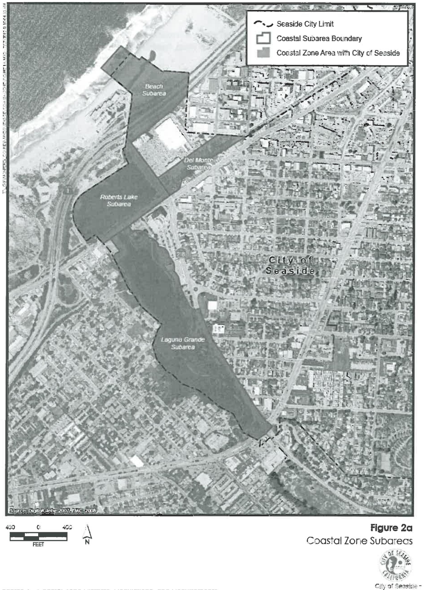
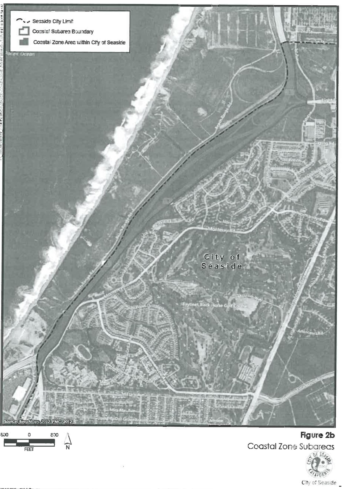
(Ord. 1006 § 4 (Att. 1), 2013)