


CONSERVATION AND OPEN SPACE ELEMENT
1.0 Introduction
1.1 Overview
1.1.1 Contents of Element
The Government Code requirements concerning topics to be addressed in conservation elements overlap many of the Government Code requirements for topics to be addressed in open space elements. For example, considerations regarding open space for the preservation of natural resources and open space used for the managed production of resources encompass the concerns of the conservation element. Therefore, this Conservation and Open Space Element of the Solana Beach General Plan is a combined element which describes existing conditions and issues related to water resources, floricultural resources, air resources, cultural resources, energy resources, and open space/visual resources. This element also contains goals, objectives, and policies established to ensure that natural resources within Solana Beach are managed wisely.
1.1.2 Key Issues
Conservation and open space issues in Solana Beach are many and diverse. The key issues involve the potential effects of general plan buildout upon natural resources such as biological systems and air resources, as well as cultural/scientific resources. Further, the scenic quality of Solana Beach’s open spaces and visual features is important, particularly in residential and park areas, and needs to be protected from potentially adverse effects of future development.
1.1.3 Overview of Goals, Objectives, and Policies
The overall goals set forth in this element are to protect and conserve the city’s natural and cultural resources, and to protect sensitive open space areas and viewsheds. The objectives and policies articulate the city’s role and responsibilities involving the management of natural and cultural resources, including open space.
1.2 Purpose
This element is mandated by state law to promote the protection, maintenance, and use of natural resources. These resources may include those that are economically productive or have intrinsic ecological/historical/archaeological value. A key purpose of this element is to guide city decisionmaking to prevent the wasteful exploitation, destruction, and neglect of natural resources.
Another key purpose of this element is to inventory existing open space land within the city and to establish a program for preserving and managing open space areas appropriately.
1.3 Authorization
As stated below, a conservation element is required pursuant to Government Code Section 65302(d):
A conservation element for the conservation, development, and utilization of natural resources including water and its hydraulic force, forests, soils, rivers and other waters, harbors, fisheries, wildlife, minerals, and other natural resources. That portion of the conservation element including waters shall be developed in coordination with any countywide water agency and with all district and city agencies which have developed, served, controlled or conserved water for any purpose for the county or city for which the plan is prepared. The conservation element may also cover:
(1) The reclamation of land and waters.
(2) Prevention and control of the pollution of streams and other waters.
(3) Regulation of the use of land in stream channels and other areas required for the accomplishment of the conservation plan.
(4) Prevention, control, and correction of the erosion of soils, beaches, and shores.
(5) Protection of watersheds.
(6) The location, quantity and quality of the rock, sand and gravel resources.
(7) Flood control.
Government Code Sections 65302(e) and 65560 through 65567 set forth the requirements for and the intent of an open space element. As stated in Section 65560(b):
“Open space land” is any parcel or area of land or water which is essentially unimproved and devoted to an open space use as defined in this section, and which is designated on a local, regional or state open space plan as any of the following:
(1) Open space for the preservation of natural resources including, but not limited to, areas required for the preservation of plant and animal life, including habitat for fish and wildlife species; areas required for ecologic and other scientific study purposes; rivers, streams, bays and estuaries; and coastal beaches, lakeshores, banks or rivers and streams, and watershed lands.
(2) Open space used for the managed production of resources, including but not limited to, forest lands, rangeland, agricultural lands and areas of economic importance for the production of food or fiber; areas required for recharge of groundwater basins; bays, estuaries, marshes, rivers and streams which are important for the management of commercial fisheries; and areas containing major mineral deposits, including those in short supply.
(3) Open space for outdoor recreation, including but not limited to, areas of outstanding scenic, historic and cultural value; areas particularly suited for park and recreation purposes, including access to lakeshores, beaches, and rivers and streams; and areas which serve as links between major recreation and open space reservations, including utility easements, banks of rivers and streams, trails, and scenic highway corridors.
(4) Open space for public health and safety, including, but not limited to, areas which require special management or regulation because of hazardous or special conditions such as earthquake fault zones, unstable soil areas, floodplains, watersheds, areas presenting high fire risks, areas required for the protection of water quality and water reservoirs and areas required for the protection and enhancement of air quality.
This combined conservation and open space element fulfills the statutory requirements related to those issues that are applicable to Solana Beach.
2.0 Existing Conditions/Issue Analysis
2.1 Water Resources
2.1.1 Watershed and Hydrology
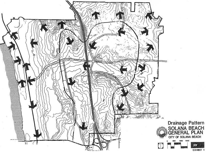
As shown on Exhibit 1, drainage from the central and south portions of Solana Beach generally flows in a southern direction to the San Dieguito River. The north and northwest portions of the city drain into the San Elijo Lagoon. As described in Section 2.4 of this element, the lagoon is a highly sensitive wetlands area. Therefore, it is very important that Solana Beach minimizes its flow of water pollutants resulting from urbanization. Such pollutants may include automobile residue, heavy metals, eroded soil, nutrients (nitrogen and phosphorus), and coliform organisms.1 Common methods that cities can use to minimize water pollutant loads involve requiring erosion control measures at construction sites and implementing periodic street sweeping programs.
2.1.2 Domestic Water Supply
The city of Solana Beach is served water by the Santa Fe Irrigation District (SFID) and the Olivenhain Water District, which obtain most of their water from the San Diego County Water Authority (SDCWA) – Metropolitan Water District (MWD) system. The SDCWA imports water and sells it to member agencies such as SFID. More than 90 percent of the SDCWA water supply consists of water imported from the Colorado River and northern California sources.
The SFID purchases unfiltered water from the SDCWA system and treats it in the 36 mgd (million gallons per day) Badger Filtration Plant owned jointly with the San Dieguito Water District. The plant is connected to the SDCWA filtered water aqueducts in the event of shutdown of the SDCWA unfiltered water pipelines or the Badger Filtration Plant.
The SFID also purchases water from the city of San Diego when runoff is available in Lake Hodges. The water, when available, is low priced. The existence of Lake Hodges and its delivery system provides a supply which is available in case of failure of the imported water system. The contract with San Diego extends until 2019.
It is the policy of MWD that it will supply the water needs within its service area. A firm supply through the year 2010 does not now exist, but it is the belief of the MWD that it will meet the water needs of the area.
Based on the SFID’s 1972 master plan,2 future water consumption will occur at a rate of approximately 0.22 acre-feet per capita per year. Solana Beach is expected to reach a population of approximately 18,317 at buildout of the general plan.3 Thus, the annual demand for water following buildout would be approximately 4,030 acre-feet. This is well within the SFID master plan projection for ultimate annual water demand in Solana Beach of approximately 6,116 acre-feet annually.4 Therefore, it is anticipated that Solana Beach’s ultimate demand for water will be met by the SFID.
2.2 Floriculture
2.2.1 Existing Operations
The principal existing “agricultural” activity in the city is the Matsumoto Floricultural Fields. These operations involve the cultivation of a variety of flowers on an approximately 15-acre site located north of Patty Hill Drive between Rios Avenue and Barbara Avenue. These flowers include carnations, tiger lilies, and iris.
The only other agricultural activity in the city is in a residentially zoned area located along Nardo Avenue and north of Nardito Lane. This site has been used historically for agricultural activities pre-dating existing zoning regulations.
Although gardens and greenhouses are allowed in residential neighborhoods under existing San Diego County zoning, they are not considered as existing “agricultural” uses since they are merely accessory uses on sites designated for residential use.
2.2.2 Future Operations
The general plan designates the Matsumoto site for agricultural use to provide for the continuation of floricultural activities. Further, such designation will preclude adverse impacts upon San Elijo Lagoon that could otherwise occur from development of the site.
The general plan does not provide for agricultural land uses at any other site within the city. The area being used for agriculture east of Nardo Avenue is designated in the land use element as low-medium residential (four dwelling units per acre).
2.3 Air Resources
2.3.1 Types of Pollutants, Pollutant Sources, and Air Quality Standards
Air pollution is generally defined as the contamination of the outdoor atmosphere resulting from human activities. In its so-called pure state, air is a gaseous mixture of nitrogen (78 percent), oxygen (21 percent), carbon dioxide (0.03 percent), inert gases such as argon (less than one percent) and traces of water vapor.
Air contaminants may be associated with natural occurrences such as volcanic eruptions, forest fires, etc. The air pollutants associated with human activities are generally classified as primary and secondary contaminants. Primary contaminants are those emitted directly by a source into the atmosphere. Secondary contaminants are formed in the atmosphere by chemical reactions of primary contaminants. The key primary and secondary air pollutants of concern are described below.
Ozone (O3) is a colorless gas with a sharp odor. It is formed in the atmosphere by a complex series of sunlight-induced chemical reactions involving oxides of nitrogen and hydrocarbons. Peak concentrations generally occur during the middle of the day since the reaction rate is directly related to the intensity of sunlight.
Carbon monoxide (CO) is a colorless, odorless gas formed by the incomplete combustion of fossil fuels. Approximately 92 percent of CO in the atmosphere is emitted by mobile sources such as trucks and automobiles. Thus, CO concentrations are generally highest in or near areas of high traffic volumes.
Oxides of nitrogen (NOx) are composed of nitric oxide (NO) and nitrogen dioxide (NO2). NO is a colorless gas emitted from mobile sources and stationary sources. NO2 is a brownish gas formed in the atmosphere by the oxidation of NO emissions.
Sulfur oxides (SOx) are byproducts of fossil fuel combustion. The principal oxide of sulfur produced in combustion is sulfur dioxide (SO2), a colorless gas with a pungent odor. Stationary sources such as power plants and petroleum refineries are primary sources of SO2 emissions. SO2 readily combines with oxygen to form sulfur trioxide (SO3), which reacts quickly with water vapor to form sulfuric acid.
Total suspended particulate (TSP) is a complex mixture of materials suspended in the atmosphere such as soil particles, sea salt, sulfates, nitrates, lead, and a variety of organic compounds. Table 1 summarizes the principal sources and effects of air pollutants.
|
POLLUTANT AND SOURCES |
GENERAL INFORMATION ON POLLUTANT EFFECTS |
|
NO2 (Nitrogen Dioxide) Mobile sources, combustion of fossil fuels. |
Produces distinctive brownish atmospheric discoloration. Causes eye, nose and throat irritation in humans and affects the lungs, causing increased susceptibility to respiratory infection. Can cause suppression of plant growth. |
|
CO (Carbon Monoxide) Mobile sources, incineration petroleum production, power generation plants. |
Harmful effects are headaches, slowed reactions and fatigue. Can cause interference with oxygen transport in blood. |
|
SO2 (Sulfur Dioxide) Mobile sources, petroleum production. Burning of fossil fuels with high sulfur content. |
Forms sulfuric acid aerosols which corrode building materials, boat and car finishes, etc. These acid aerosols penetrate the lungs and damage tissues. Rapidly converts to SO4 (particulate aerosols) in the atmosphere. |
|
O3 (Ozone) Secondary photochemical product from HC + NOx reacting in the presence of sunlight and critical temperatures. |
From mild eye irritation to possible impairment of lung function. Aggravation of respiratory and cardiac diseases, pulmonary dysfunction. Damage to vegetation: from ornamental plants to commercial food crops. |
|
TSP (Particulate Matter) Mineral Extraction & production, demolition/construction, agricultural practices, natural sources (wind blown), fire, paved and unpaved roads. |
Reduces visibility, and if in small enough particles, can be carried to the lungs. Many of the suspended particulates are toxic and are deposited on the food stuffs of animals and people. |
|
SO4 (Sulfates) Due to conversion of SO2 from stationary and mobile sources. |
Aggravation of respiratory and pulmonary disease. Produces significant reduction in visibility. Damage to vegetation. |
SOURCE: SANTA BARBARA COUNTY AIR POLLUTION CONTROL DISTRICT. 1985 ANNUAL REPORT.
2.3.2 Existing Air Quality Conditions
Ambient air quality in San Diego County is measured through a system of monitoring stations established at various locations throughout the county. These stations are operated by the San Diego Air Pollution Control District.
The station nearest to Solana Beach is in Del Mar. However, the only air pollutant measured at this station is ozone. The Oceanside monitoring station is considered most representative of Solana Beach’s ambient air quality for other pollutants. Annual air quality data for 1984 through 1986 for these stations are provided in Table 2.
|
Number of Days State/Federal Standard Exceeded; [Maximum Concentration]2 |
|||||
|
Pollutant |
Locally3 |
Countywide |
|||
|
Ozone (O3) |
1984 |
43/8 |
[.26] |
146/51 |
[.28] |
|
1985 |
48/12 |
[.18] |
148/50 |
[.22] |
|
|
1986 |
43/13 |
[.19] |
131/42 |
[.19] |
|
|
Carbon monoxide (CO) |
1984 |
0/0 |
[7.0] |
0/0 |
[16.0] |
|
1985 |
0/0 |
[8.0] |
0/5 |
[17.0] |
|
|
1986 |
0/0 |
[6.0] |
0/2 |
[16.0] |
|
|
Nitrogen dioxide (NO2) |
1984 |
0/NA |
[.23] |
0/NA |
[.23] |
|
1985 |
0/NA |
[.19] |
0/NA |
[.21] |
|
|
1986 |
0/NA |
[.21] |
0/NA |
[.22] |
|
|
Sulfur dioxide (SO2) |
1984 |
0/0 |
[.02] |
0/0 |
[.09] |
|
1985 |
0/0 |
[.06] |
0/0 |
[.08] |
|
|
1986 |
0/0 |
[.02] |
0/0 |
[.06] |
|
|
Particulates4 |
1984 |
1.7/0 |
[102] |
14.1/0 |
[164] |
|
1985 |
6.6/0 |
[124] |
23.8/0 |
[176] |
|
|
1986 |
0/0 |
[98] |
17.0/0 |
[214] |
|
1 Air Resources Board, California Air Quality Data, 1984-1986, Vols. XVI-XVIII.
2 Particulates indicated in micrograms per cubic meter (µg/m3). All other concentrations indicated in parts per million (ppm).
3 Data from Del Mar monitoring station (ozone) and Oceanside monitoring station.
4 Expressed as percentage of samples taken.
As shown on Table 2, existing air quality in the Solana Beach area is generally good. Ozone and particulates are the only pollutants that have consistently reached levels exceeding state or federal standards during recent years.
2.3.3 Impacts Resulting from General Plan Buildout
Pursuant to the land use element, the land use mix established for this general plan program is summarized in Table 3.
|
Land Use |
Acreage |
|
Estate Residential |
280.5 |
|
Low Density Residential |
253.2 |
|
Low/Medium Density Residential |
375.5 |
|
Medium Density Residential |
147.0 |
|
Medium/High Residential |
80.5 |
|
High Density Residential |
139.8 |
|
Subtotal |
1,276.5 |
|
General Commercial |
114.8 |
|
Light Commercial |
1.9 |
|
Special Commercial |
33.7 |
|
Light Industry |
13.1 |
|
Public/Institutional |
79.3 |
|
Office/Professional |
22.4 |
|
Open Space/Recreation |
231.1 |
|
Agriculture |
12.8 |
|
Right-of-Way |
88.5 |
|
Subtotal |
1,874.1 |
|
Roads |
337.4 |
|
TOTAL |
2,211.5 |
Table 4 provides a summary comparison of total annual emissions for the city’s existing land use mix versus total annual emissions for the city’s future land use mix. As shown, buildout under the adopted Land Use Plan would lead to a slight increase in annual stationary source emissions and a decrease in mobile source emissions. The projected decrease in mobile source emissions may be attributable to two factors. First, slight changes in the mix of land uses provided for in the general plan will result in a decrease in home-based vehicle trips. Thus, fewer vehicle miles of travel will occur thereby leading to a decrease in air pollutant emissions originating from automobiles. The second factor is that anticipated improvements in the automobile emission control technology would lead to fewer emissions per vehicle mile of travel. In summary, the projected decrease in mobile source emissions will more than offset the minor increase in stationary source emissions and will ultimately yield an overall decrease in total air pollutant emissions.
|
Stationary Sources |
Mobile Sources |
Total Emissions |
||||
|
Pollutant |
Existing |
Future |
Existing |
Future |
Existing |
Future |
|
Carbon monoxide |
11.93 |
12.83 |
7,713 |
5,957 |
7,724.93 |
5,969.83 |
|
Oxides of nitrogen |
64.02 |
67.16 |
464 |
337 |
528.02 |
404.16 |
|
Hydrocarbons |
1.47 |
1.66 |
1,006 |
749 |
1,007.47 |
750.66 |
|
Particulates |
1.61 |
1.65 |
– |
– |
1.61 |
1.65 |
|
Oxides of sulfur |
4.72 |
4.86 |
– |
– |
4.72 |
4.86 |
1 Based upon South Coast Air Quality Management energy consumption factors and the California Air Resources Board’s URBEMIS #1 Air Quality computer model (which does not model particulate and SOx emissions).
The county of San Diego is an area which exceeds ambient air quality standards for ozone and total suspended particulates and is therefore considered a “non-attainment” area with respect to meeting air quality goals established pursuant to the federal Clean Air Act Amendments of 1977. The San Diego portion of the 1982 “State Implementation Plan Revision” outlines a program designed to achieve healthful levels of air quality in the region. The program takes into account the additional sources of pollution likely to accompany anticipated growth and development in the county pursuant to demographic projections established by the San Diego Association of Governments.
It is therefore important to ensure that the city of Solana Beach’s projected growth does not contribute substantially to adverse long-term effects upon air quality associated with cumulative growth in the county. It is also important to ensure that Solana Beach’s local air quality environment retains its good quality.
Given the fact that automobile emissions represent the predominant source of emissions in the region, land use policies which provide for reduced automobile use are essential for the region’s ability to attain and maintain healthful air quality levels. Examples of such measures are outlined below.
1. Encourage the mixture of residential and commercial uses in and around commercial areas.
2. Encourage development which maintains a balanced relationship between jobs and housing to minimize the extent of commuter travel.
3. Establish a network of bicycle trails to facilitate non-automobile transportation.
4. Encourage new developments to provide convenient access from bikeways and public transit stops.
5. Restrict the development of auto-dependent facilities such as drive-through restaurants.
6. Integrate long-range planning and project approval procedures with air quality planning requirements.
7. Implement traffic circulation system improvements to improve traffic flow to minimize increased emissions resulting from inefficient automobile operations.
Implementing measures such as those listed above are key ways that the city of Solana Beach could contribute to minimizing the potential adverse air quality effects associated with future growth and development in the city.
2.4 Biological Resources
2.4.1 Introduction
A commitment to the conservation of biological resources begins with the recognition that human beings are part of our environment rather than apart from it. Our well being, if not our ultimate survival, depends upon our ability to minimize the degree to which human activities upset the fragile balance of natural systems. Given our incomplete understanding of the intricate web of relationships within our biosphere, a conservative approach is necessary in weighing pressures for increased urbanization with the need to preserve sensitive ecosystems.
To facilitate efforts to minimize the destruction of important biological resources due to development, this subsection of the conservation and open space element provides an inventory of sensitive resources in the Solana Beach area and a description of key considerations related to buildout of Solana Beach pursuant to the land use element of the general plan.
2.4.2 Inventory of Biological Resources
The San Elijo Lagoon is a sensitive biological resource located adjacent to and partially within the northwest portion of the city. As noted in the conservation element of the San Diego County General Plan, “[l]agoons...are of extraordinary ecological importance because they exist at the interface between air, fresh water, salt water, and land ecosystems.”5 The San Elijo Lagoon/Holmwood Canyon-San Dieguito Park area is of particular importance because it supports populations of endangered bird species such as the least tern and the Belding’s Savannah sparrow, and the declining snowy plover. The area also includes rare and endangered plant species such as San Diego thornmint, coast barrel cactus, coast white lilac, Cleveland sage chocolate lilies, and coast spice bush.6 The city of Solana Beach recognizes its ability to contribute toward the overall biological quality of the lagoon area through appropriate land use policies and planning.
Biological resources exist throughout the city of Solana Beach. The most common forms of biological resources include landscaping introduced in conjunction with urban development, horticultural activity, and grassland and chaparral on undeveloped hillside areas. While important to some degree, these resources do not represent unusual or extremely sensitive habitats. However, the age and nature of some trees located in the city could warrant preservation based more on heritage considerations as opposed to biological sensitivity.
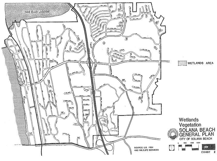
Of paramount concern are rare and endangered species and areas classified as wetlands. Within the Solana Beach city limits, natural habitat areas are practically non-existent since the city is almost completely urbanized. Although no rare or endangered species have been identified within the city, several rare and endangered species exist at the San Elijo Lagoon. As shown on Exhibit 2, the only wetlands identified in the city through the United States Fish and Wildlife Service’s “National Wetlands Inventory” program are man-made ponds on the Lomas Santa Fe Golf Course, small portions of the San Elijo Lagoon and the city’s coastline.
2.4.2 Effects of General Plan Buildout
Buildout of the general plan is expected to involve the development of existing vacant parcels and the recycling of some areas that are already developed. Such activity is not expected to affect any sensitive biological resources within the city.
The general plan provides for the retention of open space and floricultural land uses within the northwestern portion of the city adjoining San Elijo Lagoon. By limiting possibilities for new development in this area, the city expects to minimize the potential for adverse effects upon the lagoon resulting from general plan buildout.
2.5 Cultural/Scientific Resources
Introduction
Cultural resources generally consist of archaeological sites and historic sites that offer important links to our prehistoric and historic heritage. Although the California Government Code does not require consideration of cultural resources in general plans, the city of Solana Beach has chosen to include such considerations in the general plan because of their inherent importance to the Solana Beach community. It should also be noted that the preservation of these resources is mandated by the California Environmental Quality Act and is important for two basic reasons. One reason is respect for the values of Native Americans and their concern that the remains of their ancestors are left undisturbed. The second reason involves the value of these resources for anthropological and historical research. Historic structures are also a major concern since they represent important links to the heritage of Solana Beach.
A related concern is the scientific value of paleontological resources. These resources consist of subsurface prehistoric fossils. They are important for their value as specimens used in the study of the Earth’s natural history.
The following subsections briefly describe cultural and scientific resources as they relate to Solana Beach.
2.5.1 Archaeological Resources
An October 1987 records search was conducted by San Diego State University’s (SDSU) Institute for Public and Community History. The search indicates the presence of six known archaeological/historical sites within the city and 45 such sites within one mile of the city. The precise location and nature of these sites is not released to the general public in the interest of preventing disturbance of the sites. Such information is maintained on file with the city for use in identifying potential effects associated with future land development. The SDSU Institute for Public and Community History recommends that cultural resource surveys be conducted prior to any ground-disturbing activities to determine the presence of any significant cultural resources.
2.5.2 Historic Resources
Historic resources generally consist of buildings or landmarks that are significant either in terms of their relationship to local history or in terms of their unique architectural character. Solana Beach’s history dates back to the early 20th century. The area was originally settled around 1908 by George Jones. Although this area was known as Lockwood Mesa until Colonel Ed Fletcher of the Santa Fe Land and Improvement Company purchased the townsite in 1922, there exists a house at the top of Del Mar Downs Road that dates to as early as the turn of the century. On March 5, 1923, Fletcher filed the original subdivision map of Solana Beach. The community has grown from an agricultural community to a highly developed urban area.
According to long-time residents of the city, nearly all of the city’s earliest structures have given way to new development. The oldest remaining structure is generally believed to be the Gonzales House on the 700 block of Ida Street in the Eden Gardens area. This house was constructed prior to 1925 and has been well maintained. As a link to the earliest days of Solana Beach, the Gonzales House is considered an an important local historic resource.
2.5.3 Paleontological Resources
Paleontological resources are prehistoric plant and animal fossils embedded in subsurface geologic materials. They are important resources used in the conduct of natural history research in that they help to reveal the nature of biological evolution and geologic changes. The geologic formations in Solana Beach consist of marine sedimentary deposits which are expected to contain fossils. However, no significant fossil localities have been identified within the city. The localities found nearest to Solana Beach are situated along the coast between Del Mar and La Jolla.7
These resources include fossil mollusk localities, fossil calcereous nannoplankton localties, and fossil mammal localities. Aquatic shell fossils have also been found at the northwest corner of the city of Solana Beach, and they may extend into the city in very small areas.
A method to identify potentially significant paleontological resources in the city is to require a paleontological survey in conjunction with any future ground-disturbing construction activity. Should any such resources be unearthed, a paleontologist could be empowered to halt grading activities until the resources are sufficiently retrieved.
2.6 Energy Resources
2.6.1 Available Energy Supply
Solana Beach’s non-transportation energy supply consists of natural gas and electricity supplied by the San Diego Gas and Electric (SDG&E) company. The city’s electrical needs are served by SDG&E’s substations in Del Mar, Encinitas, and Rancho Santa Fe. SDG&E provides electrical power flow using an integrated mix of primary energy resources – oil, natural gas, hydropower, coal, geothermal, co-generation and nuclear. A substantial portion of SDG&E’s electrical supply is purchased from other utilities. Similarly, SDG&E purchases its entire natural gas supply from Southern California Gas Company.
2.6.2 Existing Energy Demand
Tables 5 and 6 below provide specific energy consumption factors considered applicable to land uses in Solana Beach.
|
Land Use |
Quantity |
|
Single Family Residential |
6,665 cubic feet per unit |
|
Multi-Family Residential |
3,918 cubic feet per unit |
|
Office |
2.0 cubic feet per square foot |
|
Commercial |
2.9 cubic feet per square foot |
|
Public/Institutional |
2.0 cubic feet per square foot |
|
Industrial |
3.3 cubic feet per square foot |
1 Source: Southern California Gas Company, 1986.
|
Land Use |
Quantity |
|
Residential |
6,081 kilowatt hours per dwelling unit |
|
Office |
8.8 kilowatt hours per square foot |
|
Retail |
11.8 kilowatt hours per square foot |
|
Public/Institutional |
8.8 kilowatt hours per square foot |
|
Industrial |
8.8 kilowatt hours per square foot |
1 Source: Southern California Edison, 1985.
Based on the energy consumption factors identified above and existing land use characteristics (as of 1988), it is estimated that approximately 78,731.6 megawatt hours of electricity are consumed annually in Solana Beach. Annual natural gas consumption is approximately 406.1 million cubic feet.
2.6.3 Impacts Resulting from General Plan Buildout
The Solana Beach General Plan Land Use Element identifies the mix and quantity of land uses to be developed in Solana Beach. Based upon the energy consumption factors provided in Section 2.6.2 and the maximum general plan buildout scenario, Solana Beach’s ultimate natural gas consumption is projected at approximately 442.8 million cubic feet annually while electrical consumption is projected at approximately 84,657.2 megawatt hours annually. These consumption levels represent increases of approximately 9.0 percent for natural gas and 7.5 percent for electricity. These increases are not significant and are within the parameters of SDG&E’s projected load growth for the Solana Beach area.
As new development occurs and older structures are refurbished, opportunities to implement energy conservation measures should be taken. Appropriate planning and structural design techniques will serve to minimize increasing demands for non-renewable resources and will reduce Solana Beach’s vulnerability to future energy supply shortages. Further, such measures will serve larger regional and national interests in terms of minimizing Solana Beach’s dependency on non-renewable energy supplies.
Energy savings also can be achieved through land planning that encourages a balance between residents and employees (ie., reducing the need for long commutes from home to work) and planning that maximizes opportunities for the use of non-automobile or public transportation.
Title 24 of the California Administrative Code contains building code provisions regarding energy conservation measures to be used in structural design. These measures involve proven technologies such as building insulation, weatherstripping, insulation of water heaters and pipes, water flow restrictors, and energy-efficient lighting systems. By incorporating Title 24 considerations into the design review process, the city can contribute to the goal of minimizing increased energy consumption levels.
In addition to conservation measures, the city can encourage the exploitation of renewable energy resources such as solar energy. For example, land use planning that facilitates solar access serves to encourage the use of renewable solar energy for space heating and water heating rather than continued use of fossil fuels.
2.7 Open Space and Visual Resources
2.7.1 Importance of Open Space
As stated in Government Code Section 65561, “...the preservation of open space land...is necessary not only for the maintenance of the economy of the state, but also for the assurance of the continued availability of land for the production of food and fiber, for the enjoyment of scenic beauty, for recreation and for the use of natural resources.”
The inherent importance of providing for adequate open space is to supply breaks in the pattern of development which offer visual relief from intense urban environments. Further, the provision of open space is important to facilitate the wise use of natural resources and to protect public health and safety. Section 1.3 of this element cites Government Code Section 65560(b), which identifies four basic categories of open space considered necessary and appropriate for the provision of a balanced urban development pattern. These categories are described below in relation to conditions in Solana Beach.
First, open space for the preservation of natural resources is important to protect sensitive ecological systems. For example, wetlands habitat areas and rare and endangered plant and wildlife communities are often designated as open space to preclude development activities that might destroy significant biological resources. As discussed previously in Section 2.4, the San Elijo Lagoon located immediately northwest of the city represents a significant wetlands area of concern. The Solana Beach General Plan designates open space along the area north of Canyon Drive to protect the lagoon from adverse effects that might otherwise occur with urbanization of these areas.
Second, open space used for the managed production of resources is important to maintain adequate supplies of food and fiber. Thus, agricultural lands and mineral resource zones are often designated as open space to ensure their continued productivity. In Solana Beach, the area located north of Patty Hill Drive (between Rios Avenue and Barbara Avenue) is designated for agricultural use to provide for the continuation of existing floricultural operations.
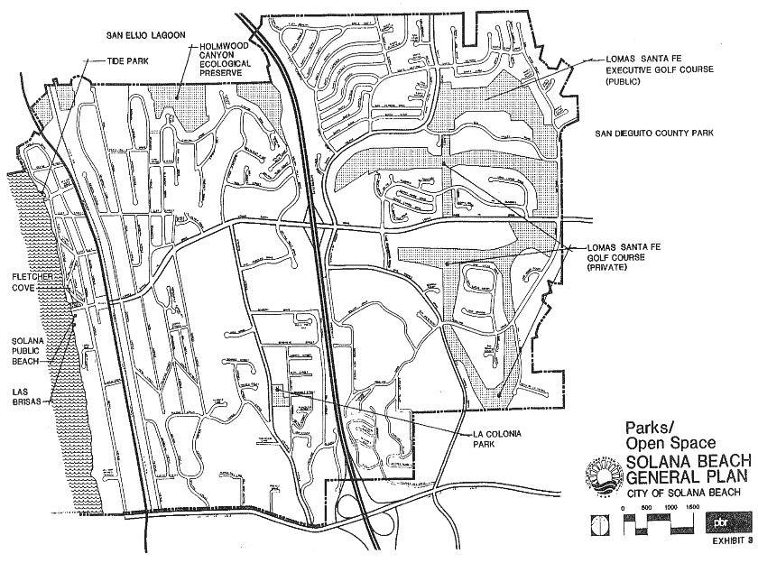
Third, open space used for outdoor recreation is important to meet the community’s recreational and cultural needs. Parkland and beaches are examples of this type of open space. Solana Beach offers approximately 1.26 miles of coastline used for beach recreation, the four-acre La Colonia Park, and the Lomas Santa Fe Golf Courses. In addition, the city is adjacent to major regional open space areas in the form of San Dieguito Park, Holmwood Canyon and San Elijo Lagoon. The provision of an adequate level of parks and recreational opportunities is important to maintaining a well-balanced community.
Fourth, open space for public health and safety is important to preclude or minimize potential hazards associated with floods, fires, slope stability, and earthquakes. Further, public health and safety interests may necessitate the designation of open space areas to protect the quality of water resources. In Solana Beach, open space is designated in the Holmwood Canyon area partly as a measure to manage potential fire hazards. Similarly, open space designated on the coastal bluff overlooking Fletcher Cove is partly intended to ensure that safety hazards involving bluff stability are minimized.
2.7.2 Types of Open Space
PERMANENT OPEN SPACE
In general, land uses expected to remain committed to open space usage during the life of a general plan are regarded as permanent open space. For example, Solana Beach Park (also known as Fletcher Cove), Tide Park Beach, La Colonia Park, Lomas Santa Fe Country Club, and Lomas Santa Fe Executive Golf Course are typical of permanent open space uses (Exhibit 3). Other types of permanent open space areas include school playgrounds and the Holmwood Canyon area.
INTERIM OPEN SPACE
Interim open space areas are typically private properties that are currently vacant or used for agriculture. Unlike permanent open space uses, which are usually publicly owned sites, vacant lands can be expected to be developed sometime during the life of the general plan. Until such time as development occurs, these land uses offer temporary open space values. In Solana Beach, the vacant land located southeast of the Lomas Santa Fe Drive/Granados Avenue is an example of interim open space since it is designated for future residential development.
2.7.3 Unique/Significant Open Space and Visual Features
The city of Solana Beach offers several open space features within and around the community. The key open spaces within the city include beaches, parks, and golf courses described previously and shown on Exhibit 3 as well as the Holmwood Canyon area adjoining San Elijo Lagoon. The lagoon and San Dieguito Park are significant open space features adjacent to the northwestern and eastern portions of the city, respectively.
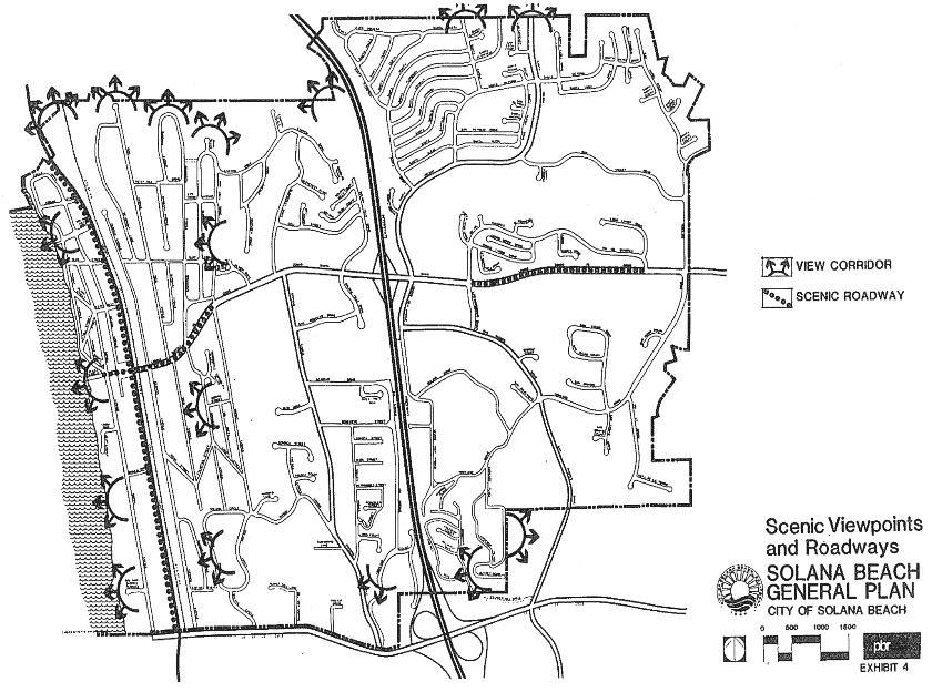
The most significant visual feature in Solana Beach is the Pacific Ocean. Scenic ocean views are available from several vantage points due to the city’s hilly terrain. As shown on Exhibit 4, the most scenic viewpoints are found at Las Brisas Viewpoint (a small clifftop area south of Solana Beach Park), along Solana Circle, and in the vicinity of the Avocado Place/Jeffrey Road intersection. Further, motorists heading west on Lomas Santa Fe Drive west of Nardo Avenue are afforded particularly scenic views of the ocean. Other scenic views are available to residents overlooking the golf courses in the eastern portion of the city and to residents overlooking the Holmwood Canyon/San Elijo Lagoon area.
3.0 Goals, Objectives, and Policies
GOAL 3.1
TO PROTECT AND CONSERVE THE CITY’S NATURAL AND CULTURAL RESOURCES
Objective 1.0
Ensure that the quality of water resources do not violate state and federal water quality standards as a result of development within the city of Solana Beach.
Policy 1.a The city shall cooperate with District 15 of the Regional Water Quality Control Board and other agencies within San Diego County in the implementation of the 208 water quality program.
Policy 1.b The city shall require the incorporation of adequate erosion control measures into development projects that may otherwise impact water resources adversely. Such measures shall be reviewed by the Planning and Engineering Departments and shall include sandbagging of newly graded slopes, prompt planting of disturbed areas, phasing of grading and construction activities to minimize exposed areas susceptible to erosion, and the routing of runoff flows through desilting basins prior to discharge into any watercourse.
Policy 1.c The city shall continue its street sweeping program to minimize the urban pollutant load which enters the city’s drainage system.
Policy 1.d The city shall encourage the use of minor natural watercourses as local open spaces.
Policy 1.f The city shall participate in cooperative agreements with other agencies in programs which encourage research and establishment of innovative sewage treatment methods as alternatives to ocean outfall and septic tanks.
Objective 2.0
Maintain adequate domestic water supplies for all residents and uses within the city.
Policy 2.a The city shall require all new developments to incorporate water conservation measures into project design to the greatest extent possible. Such measures may include, but are not limited to, the use of plumbing fixtures which reduce water usage (in accordance with Title 24 of the California Administrative Code) and xeriscape landscaping which maximizes the use of drought-tolerant plant species and drip irrigation systems.
Policy 2.b The city shall support projects involving water reclamation (such as the San Elijo treatment plant) by using reclaimed water for irrigation of public landscaped areas to the greatest feasible extent. Further, the city shall encourage the use of such water in privately owned areas.
Policy 2.c The city shall cooperate with the San Diego County Water Authority, the Metropolitan Water District of Southern California, and the Santa Fe Irrigation District by providing the agencies with general plan buildout projections and by keeping the agencies fully informed of amendments to the general plan which may affect the district’s planning for the provision of adequate water supplies.
Objective 3.0
Conserve and recycle important resources.
Policy 3.a The city shall participate in the county’s efforts to recycle waste products such as glass, broken concrete, asphalt, etc. for use as construction materials.
Policy 3.b The city shall encourage efforts to increase public participation in recycling.
Objective 4.0
Encourage sound environmental planning practices in all developments.
Policy 4.a The city shall use the environmental review procedures established by the California Environmental Quality Act (CEQA) to ensure that potential adverse effects upon natural and cultural resources are identified.
Policy 4.b The city shall not permit land uses that would have unavoidable significant adverse impacts upon natural or cultural resources unless a statement of overriding considerations is adopted by the Solana Beach City Council.
Policy 4.c Technical reports made available to the public in conjunction with environmental documentation shall include summaries written for laypersons (e.g., soils and geology reports that minimize the use of technical jargon).
Objective 5.0
Preserve important biological habitat and protect sensitive, rare, and endangered species of flora and fauna.
Policy 5.a The city shall require that all development proposals provide adequate mitigation measures for identified significant biological resources, including selective preservation, replanting, sensitive site planning techniques, the provision of replacement habitat, and/or other appropriate measures.
Policy 5.b The city shall preserve sensitive habitat areas as permanent open space.
Policy 5.c The city shall establish a heritage tree program which identifies mature trees that are to be preserved and protected from public and private development activities. Further, this program shall set forth procedures to be followed by the city staff in the site plan review process to ensure compliance with the program and shall outline appropriate measures to preserve mature trees.
Policy 5.d Permanent open space preserves designated for the purpose of protecting biological resources shall be managed primarily for their inherent ecological value. Recreational uses shall be considered a secondary activity. The use of hiking and riding trails shall be monitored periodically by a qualified biologist to determine their impact and viability as uses compatible with the biological preserve.
Policy 5.e The city shall cooperate with other appropriate agencies as necessary to preserve significant habitats in rapidly developing areas, including the acquisition of important habitats.
Policy 5.f The city shall enforce measures established elsewhere in this element to minimize existing and potential future impacts upon San Elijo Lagoon and other important marine ecosystems.
Objective 6.0
Prevent the loss of important historical, archaeological, and paleontological resources.
Policy 6.a The city shall complete an inventory of local historic resources and cultural landmarks and shall establish a list of significant resources to be preserved.
Policy 6.b The city shall require that sites proposed for future development are to be evaluated by certified archaeologists and/or paleontologists in accordance with the California Environmental Quality Act. Where potentially significant adverse impacts are identified, the city shall require appropriate mitigation measures such as in situ preservation or professional retrieval.
Policy 6.c The city shall implement the objectives and policies established in the community design element of the general plan which promote the preservation of historic landmarks, focal points, and special features.
Policy 6.d The city shall encourage and support the acquisition of significant cultural resources by private and/or public entities interested in preserving such resources.
Policy 6.e The city shall establish a historic preservation section within its zoning ordinance.
Objective 7.0
Reduce the city’s demands upon conventional, non-renewable sources of energy.
Policy 7.a The city shall require new developments to incorporate energy conservation measures and promote alternative energy systems.
GOAL 3.2
TO PROTECT AND ENHANCE SENSITIVE OPEN SPACE AREAS AND VIEWSHEDS
Objective 1.0
Preserve existing open spaces at appropriate locations throughout the city.
Policy 1.a The city shall restrict development along the bluffs overlooking Solana Beach and other areas such as the Atchison Topeka and Santa Fe railroad right-of-way to those uses which retain the open space character of these areas (eg., parks, open space spines, trails, etc.) in accordance with the Open Space Plan.
Policy 1.b The city shall ensure the preservation of existing public beaches, parks, trails, open space areas, and golf courses pursuant to the adopted land use element of this general plan.
Policy 1.c The city shall implement the objectives and policies established in the community design element of the general plan which promote the preservation and enhancement of open space features.
Objective 2.0
Preserve the city’s hillside areas and natural landforms in their present state to the greatest extent possible.
Policy 2.a The city shall enact a hillside development ordinance which contains development standards to: 1) maintain the natural visual character of the hillsides to the maximum feasible extent, 2) integrate architecture and landscaping into the hillside setting, 3) preserve significant visual and environmental elements, 4) minimize grading impacts, 5) restrict development on slopes of greater than 25 percent, 6) preserve prominent ridgelines, 7) require the contouring of manufactured slopes to blend with natural slopes, 8) encourage the use of innovative structural designs which adapt to the natural topography, 9) discourage “stair-stepping” of building pads, 10) require the blending of colors and materials with the hillside environment, and 11) provide for the planting of slopes with fire-retardant, drought-tolerant materials.
Objective 3.0
Maintain the quality of scenic views in the city as well as the overall visual quality of the city’s landscape.
Policy 3.a The city shall require new developments to be subjected to visual impact analyses where potential impacts upon sensitive locations are identified.
Policy 3.b The city shall require that new structures and improvements be integrated with the surrounding environment to the greatest possible extent.
Policy 3.c The city shall enforce its adopted design guidelines as specified in the community design element of this general plan.
Policy 3.d The city shall encourage the preservation of private views, including policies for tree trimming and removal.
Policy 3.e The city shall designate areas that will be subject to a dark sky policy.
GOAL 3.3
TO MEET THE NEEDS OF THE ENTIRE COMMUNITY BY PROVIDING AN ADEQUATE LEVEL OF PARKS AND RECREATIONAL OPPORTUNITIES.
Objective 1.0
Provide a minimum of three acres of public park and recreational facilities for every 1,000 residents.
Policy 1.a The city park land required shall be a combination of beaches, playlots, regional parks, neighborhood parks, community parks, and joint use of public school recreational areas.
Policy 1.b The city shall establish parks throughout the city. Such parks may include appropriate facilities such as tot lots, active play areas, passive open space areas, picnic facilities, and sports fields.
Policy 1.c The city shall evaluate the potential to purchase publicly owned land when it becomes available.
Objective 2.0
Establish a master plan of hiking/jogging, bicycle, and equestrian trails.
Policy 2.a The city shall adopt a master plan of trails and shall develop at least one mile of trails annually until completion of the planned system. This trail system shall link the city’s greenbelts, parks, and open space to the greatest extent possible.
Objective 3.0
Establish a park funding program to ensure that the costs of acquiring, improving, and maintaining city recreational facilities are consistent with the ability of residents to pay.
Policy 3.a The city shall adopt a park funding program by based on general revenue funds, user fees, state and federal grants, and developer contributions of land, facilities, and in lieu fees.
Policy 3.b The city shall require developers of residential land to dedicate land or fees for parks to ensure the continued provision of at least 3 acres of park land for every 1,000 residents.
4.0 The Conservation and Open Space Plan
As discussed in Section 2.0 of this conservation and open space element, a wide variety of natural resources, cultural resources, and open space areas are subject to the effects of urban development. To ensure that these issues receive proper consideration, the implementation of the policies established in this conservation and open space element is primarily the responsibility of the city Planning Department. Through its site plan review process, the Planning Department takes into consideration the compatibility of proposed development activities with natural resources, cultural resources, and open space areas.
The Planning Department is responsible for ensuring that proposed general plan amendments and land development proposals are processed pursuant to the California Environmental Quality Act (CEQA). In keeping with this responsibility, the Planning Department is able to identify potential adverse effects associated with proposed actions as related to natural resources, cultural resources, and open space. Potential adverse effects that are deemed significant should be either avoided or mitigated unless a statement of overriding considerations is adopted by the city.
As the ultimate authority in Solana Beach regarding land use policies, the City Council is responsible for approving or denying proposed general plan amendments and development proposals. The City Council has a related responsibility to certify that CEQA has been complied with adequately and, if necessary, to adopt statements of overriding considerations specifying why any significant impacts to natural resources, cultural resources, or open space are outweighed by other public interests.
5.0 Glossary
Coastal Bluff: Any bluff where the toe of slope is now, or within the past 200 years has been, subject to marine erosion.
Conservation: The management of natural resources to prevent waste, destruction, or neglect.
Erosion: The process by which soil and rock are detached and moved by running water, wind, ice, and gravity.
Lagoon: An area of shallow salt water separated from the sea by sand dunes.
Non-renewable Natural Resources: Inanimate resources that do not increase significantly with time and whose use diminishes the total stock (eg., minerals, fossil fuels and fossil water).
Renewable Natural Resources: Resources that can be replaced by natural ecological cycles or sound management practices (eg., forests and plants).
Watershed: The total area above a given point on a watercourse that contributes water to the flow of the watercourse; the entire region drained by a watercourse.
Wetlands: Areas that are permanently wet or periodically covered with shallow water, such as saltwater and freshwater marshes, open or closed brackish marshes, swamps, mud flats, and fens.
American Chemical Society, Cleaning Our Environment: A Chemical Perspective, 1978.
James M. Montgomery Consulting Engineers, Inc., Santa Fe Irrigation District: Updated Master Plan for Water System Development, October 1972.
Based upon an overall factor of 2.66 persons per dwelling unit and a total of 6,886 dwelling units at general plan buildout.
Ibid., p. 14.
County of San Diego, Conservation Element of the San Diego General Plan, revised May 1983, p. X-33.
Ibid., p. X-K-25.
California Division of Mines and Geology, Geology of San Diego Metropolitan Area, California – Bulletin 200, 1975.