


Chapter 33.16
EXISTING PHYSICAL CONDITIONS
Sections:
33.16.010 Existing physical conditions.
33.16.070 Proposed policies – Growth plan and future land use.
33.16.100 Summary of constraints and opportunities.
33.16.010 Existing physical conditions.
This section summarizes existing physical conditions in the 24 Road Corridor study area, including land use, circulation, open space, utilities and environmental conditions. Existing zoning and patterns of property ownership are also discussed. This section includes a general summary of development constraints and opportunities.
The 24 Road Corridor study area is located in western Grand Junction, between I-70 on the north and U.S. 6/50 on the south. As defined for this study, the corridor includes approximately 1,000 acres on the east and west sides of 24 Road between 23 Road and 24 1/2 Road.
Commercial development along Road 24 1/2
(Res. 109-00 § 4, 11-1-00)
33.16.020 Existing land use.
The predominant character and use of land within the study area is agricultural. Much of this area remains in 40-acre parcels, typical of development patterns in rural communities. Commercial land uses are clustered near Mesa Mall and industrial uses are primarily located adjacent to or near U.S. Highway 6/50.
The study area and adjacent environs were annexed into the City in 1995 – one of the largest area annexations. The annexation of this area provided the City with control of the development of the western-most edge of the City as well as the area north of Mesa Mall. The study area and environs are shown on Figure 1. Existing land use is summarized in Table 10 and is illustrated in Figure 2.
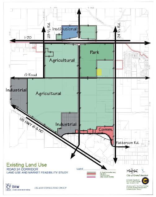
Figure 2: Existing Land Use
|
Category |
Area (acres) |
|
Residential |
52.80 |
|
Commercial |
9.57 |
|
Industrial |
71.40 |
|
Agricultural |
43.86 |
|
Institutional |
26.70 |
|
Undeveloped |
47.60 |
|
Undeveloped/Agricultural |
651.27 |
|
Public |
114.70 |
|
Total |
1,018 |
Source: BRW, Inc., and the City of Grand Junction Community Development Department.
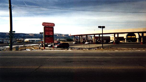
Existing commercial development near Patterson Road and 24 Road
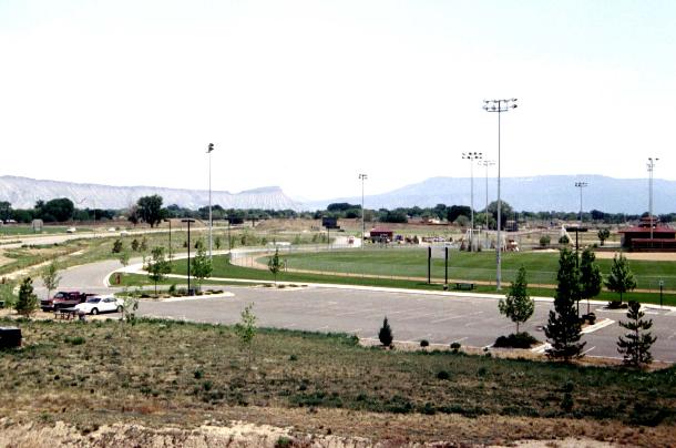
Canyon View Park
Leach Creek and undeveloped land east of 24 Road
(Res. 109-00 § 4, 11-1-00)
33.16.030 Circulation.
(a) The 24 Road Corridor is bordered on the north and south by major traffic routes in the Grand Junction area. Average daily trip volume along Interstate 70, where motorists are passing through Grand Junction, is approximately 7,000 ADT. Of the approximately 28,000 vehicles per day using U.S. Highway 6/50, most of these trips are predominately local in origin and generate the demand that has resulted in the commercial uses that line the roadway. There are approximately 4,000 vehicles per day using 24 Road between I-70 and Patterson Road. Patterson Road connects Mesa Mall with downtown and the eastern quadrant of Grand Junction and carries approximately 7,000 vehicles per day.
(b) The Colorado River and the Burlington Northern Railroad tracks run parallel to and south of U.S. Highway 6/50. One of the two bridges connecting Grand Junction with the residential development south of the river aligns with 24 Road.
(c) The area displays a hierarchy of existing streets to serve transportation regionally and within the area. The descending hierarchy of roads within the study area, based upon traffic volumes, is:
(1) U.S. Highway 6/50 is the major east/west corridor carrying inner-city and regional traffic.
(2) Patterson Road carries the majority of traffic from the Mall into the City.
(3) I-70 serves mostly pass-through traffic.
(4) G Road provides east/west access within the City.
(5) 24 Road provides north/south access between Redlands, the Mall and North Valley.
This data indicates that the highest traffic volumes are along the east-west streets and highlights a dilemma faced by the City’s transportation engineers. Travel patterns created by and reinforcing the land use pattern place the greatest demand on the east-west street network. However, there are few east-west streets that are continuous across the City. F Road, which becomes Patterson Road east of 24 Road, and G Road are both east-west streets and carry large volumes of traffic through several residential neighborhoods. The impact upon the neighborhoods limits the effective capacity of these roadways.
(d) An important public policy consideration is whether incentives should be created for motorists to use I-70 (which is significantly under-capacity) to travel east-west and then use the arterial and collector street network to travel north-south (e.g., 24 Road and other north-south arterial streets). Such an incentive could justify the expansion of 24 Road. The problem is that neither regional nor local land use patterns support that concept.
(e) The City is in the process of expanding 24 Road from two lanes to three lanes, adding a center turn lane and median. The Steering Committee and property owners would like to see 24 Road expanded to a five-lane landscaped parkway. There are three constraints which restrict the five-lane expansion:
(1) The City is receiving 80 percent of the funding for the three-lane expansion from federal and State sources and funding is only available to construct three lanes.
(2) The proximity of Leach Creek would require that all of the additional rights-of-way for a five-lane roadway would be acquired from properties on the west side of 24 Road. Several west side property owners have already voiced their concern about such an approach. The relocation of Leach Creek is a possibility, but estimates indicate that it may be prohibitively expensive.
(3) Current and projected traffic volumes, based upon the proposed new zoning designations implementing the Growth Plan, do not warrant five lanes.
(Res. 109-00 § 4, 11-1-00)
33.16.040 Open space.
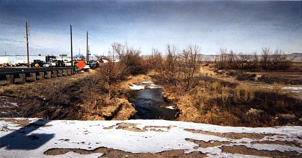
The City of Grand Junction has constructed regional park improvements in the 24 Road Corridor at the southeast corner of the I-70 interchange. Canyon View Park, a 120-acre regional park that provides ball fields and other recreational improvements, attracts users from throughout Mesa County. Two branches of Leach Creek flow from the north toward the Colorado River through the corridor. These include an open channel tributary on the east side of 24 Road south of I-70 as well as the main branch of Leach Creek which flows through the park to the west. As a result, there are two outfalls on the north side of G Road. The City is discussing the potential for using the Leach Creek drainage alignment as a route for a trail to connect the regional park with the extensive Colorado River trail system.
(Res. 109-00 § 4, 11-1-00)
33.16.050 Utilities.
The 24 Road Corridor is served by all major utilities, including water, sanitary sewer, electric, natural gas, cable television, and telephone. The City is currently involved in the process to upgrade and replace water and sanitary sewer lines in the area.
(Res. 109-00 § 4, 11-1-00)
33.16.060 Environmental.
There are limited environmental constraints to use or development land within the 24 Road Corridor. The land is gently sloped to the southwest, toward the Colorado River. Flows in Leach Creek are minimal, yet are increasing over time as runoff from development is added to the drainage basin. The Corps of Engineers has identified vegetation indicative of wetlands along Leach Creek, which may pose a constraint to filling and/or relocating this drainage.
(Res. 109-00 § 4, 11-1-00)
33.16.070 Proposed policies – Growth plan and future land use.
The land uses proposed in the Growth Plan within the 24 Road Corridor subarea are divided between approximately equal portions of commercial and residential uses. Residential densities would not exceed eight units per acre. Commercial and industrial uses would likely consist of a mix of strip retail, big-box discount retailers, and warehousing and distribution.
The vision and policies contained within the Growth Plan applicable to the area are:
(a) To “encourage the conversion of heavy commercial and industrial uses along 24 Road, Patterson Road and U.S. Highway 6/50 near Mesa Mall to a mixture of retail/service commercial and multifamily uses.” (Policy 8.6)
(b) To “support integrated commercial development using shared access points along 24 Road, Patterson Road and U.S. Highway 6/50 in areas designated for commercial use.” (Policy 8.7)
(c) To “ensure that capital improvement and land use decisions are consistent with the development of 24 Road as an arterial parkway and community gateway.” (Policy 8.8)
Future land use in the Grand Junction Growth Plan is illustrated in Figure 3.
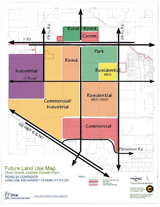
Figure 3: Future Land Use Map (from Grand Junction Growth Plan)
(Res. 109-00 § 4, 11-1-00)
33.16.080 Zoning.
Existing zoning in the area is comprised of several zoning districts including:
(a) Commercial (C-2).
(b) Highway Oriented (HO), which is primarily commercial uses.
(c) Industrial (I-1), light industrial uses.
(d) Residential Single-Family (RSR-F), not to exceed one dwelling unit per five acres.
(e) Residential Single-Family (RSF-2), not to exceed two dwelling units per acre.
(f) Planned Recreational Vehicle Resort (PRVR).
(g) Planned Residential (PR).
(h) Public Zone (PZ) (Canyon View Park).
The breakdown of the existing allocation of land area for each zoning designation in the subarea is shown below in Table 11. Existing zoning (September 1999) is shown in Figure 4.
|
Category |
Approximate Area (acres) |
|
Commercial (C-2) |
164 |
|
Highway Oriented (HO) |
417 |
|
Industrial (I-1) |
48 |
|
Residential Single-Family (RSR-F) |
161 |
|
Residential Single-Family (RSF-2) |
9 |
|
Planned Recreational Vehicle Resort (PRVR) |
76 |
|
Planned Residential (PR) |
29 |
|
Public Zone (PZ) |
115 |
|
Total |
+/-1,018 |
Source: BRW, Inc., and the City of Grand Junction Community Development Department.
As this table indicates, the predominate zoning classification is commercial zoning districts, C-2 and HO, which comprise more than 50 percent of the zoned land area. The City is facing some difficulty due to the fact that some of the property owners, under the proposed new zone designations derived from the Growth Plan process, would not be allowed the commercial uses they have today.
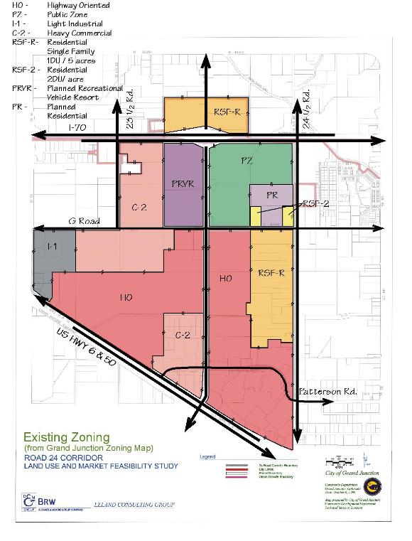
Figure 4: Existing Zoning
(Res. 109-00 § 4, 11-1-00)
33.16.090 Property ownership.
Property ownership patterns in the area reflect the existing agricultural land use pattern of large farms. Where (relatively) new development has occurred, the subdivision of property has resulted in a significantly smaller lot pattern. Although the largest parcel is almost 200 acres, the average parcel size is eight acres. Three private property owners control 41 percent or 420 acres of land within the study area. Publicly owned property, primarily Canyon View Park, comprises approximately 115 acres, making the City the third-largest land owner in the area.
(Res. 109-00 § 4, 11-1-00)
33.16.100 Summary of constraints and opportunities.
The following summarizes the general constraints and opportunities for the project area, relative to physical conditions and considering the import of market and demographic factors as discussed in Section 2. (See Figure 5.)
(a) Retail Synergism. Mesa Mall, the regional retail center for Mesa County, will continue to offer a synergistic relationship for additional retail users who will want to locate near the Mall, as well as adjacent to U.S. Highway 6/50.
(b) Land Use Supply and Demand. Based upon the market analysis, there is a greater supply of land in all categories than demand exists for the foreseeable future. Development will occur in a cyclical manner, e.g., a significant amount of development may occur over the next two years, but then no additional development may occur for the next eight years until the supply of space is absorbed.
(c) Development Cycles. It is likely that a fairly typical cycle of development will occur in Grand Junction: leading with employment, followed by single-family residential, commercial, and multifamily residential.
(d) Population Trends. According to the Growth Plan, since 1980, the population aged over 65 increased by over 30 percent, while at the same time the population aged 15 to 29 decreased by 30 percent. What this means is Grand Junction is a “graying” community. The increase in seniors can be attributed to climate, quality of life, health care facilities, and affordable housing. Therefore, recent population growth in Grand Junction has more to do with these factors than as a result of employment growth.
(e) Employment Trends. According to the Growth Plan, the top 10 employers in Grand Valley are either public employers or in the health care sector. City Market is the only employer on the list of major employers that does not fit into one of these two categories. This trend is likely to continue in the future.
(f) Transportation Circulation Patterns. The planned expansion of 24 Road from two lanes to three lanes (adding a center turn lane and median) will improve safety and increase capacity along the road corridor. The City’s plans for a secondary street system connecting to 24 Road is essential to properly serve the anticipated development.
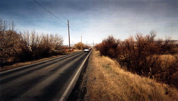
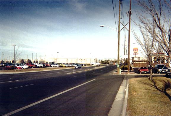
Existing conditions along 24 Road, including Leach Creek on the right
(g) Infrastructure Availability. Adequate infrastructure is available to serve development in the corridor. Utilities are in place and are being upgraded.
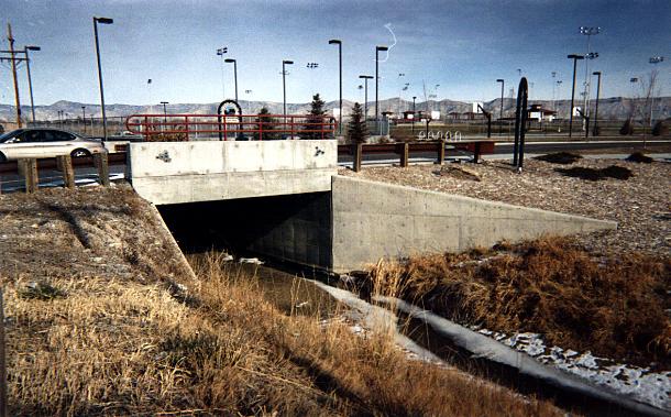
Leach Creek drainage structure near Canyon View Park
(h) Environmental Conditions. There are few environmental constraints in the project area, other than Leach Creek and associated wetlands, which may impact development.
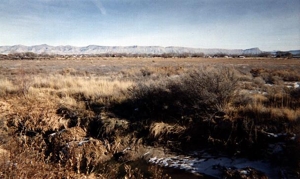
Leach Creek wetlands
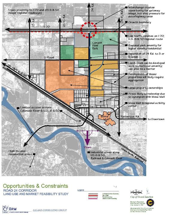
Figure 5: Opportunities and Constraints Map
(Res. 109-00 § 4, 11-1-00)