


Chapter 17.10
SIGN STANDARDS
Sections:
17.10.010 Intent and Applicability.
17.10.050 Standards Applicable to All Signs.
17.10.060 Standards Applicable to Specific Sign Types.
17.10.010 Intent and Applicability
A. Intent. The intent of this section is to:
1. Preserve the unique character of the City as reflected in distinct areas and districts within the City by ensuring signs contribute to an appropriate sense of place.
2. Enhance the visual quality of the community reflected in the visual priority of buildings, open spaces, streetscapes, and landscape.
3. Ensure safety of pedestrians, motorists or other users of the public rights-of-way and open spaces by ensuring signs are maintained and structurally safe, and do not distract or reduce the effectiveness of public safety signs.
4. Promote economic viability by assuring that the City will be a visually pleasant place to visit, conduct business, and live.
5. Provide effective and efficient identification and communication for businesses without excessive competition for visual attention.
6. Protect property values by minimizing adverse effects of signs on adjacent property, which can occur from conditions such as light trespass, obstructing the views and access, or visual blight.
7. Promote the civic beauty of the community and protect public investments in rights-of-way and open spaces by limiting the impact of sign clutter while enabling the public to locate goods, services, and facilities without difficulty and confusion.
8. Protect and enhance public and private investment in property by encouraging the design, scale, and placement of signs that are appropriately conspicuous, visible, and legible.
9. Ensure that the constitutionally guaranteed right of free speech is protected while allowing signs as a means of public communication.
B. Applicability. All new signs and replacement of existing signs shall require a sign permit demonstrating compliance with these sign standards, unless exempt from a permit by GMC 17.10.020. Ordinary maintenance, care or repair of existing signs or change of copy without altering the essential construction elements of an existing sign shall not require a permit for zoning and design standards, but any electrical or building code issues may require permitting. (Ord. 2518 § 2 (LDC § 10.01))
17.10.020 Exempt Signs
The following signs are exempt from the permit process provided they meet all other applicable requirements of this Code, and unless specifically noted do not count towards the size allocation standards in this Code:
A. Address Signs. Signs clearly indicating the property address are encouraged to enhance the ability of public safety and emergency services personnel to locate the property. One wall and one freestanding sign per address up to two square feet each, provided the following standards are met:
1. Address signs on buildings shall be mounted between four feet and nine feet high to enhance visibility.
2. Freestanding address signs shall be located at the primary access point and shall be no more than three and one-half feet high to minimize sight obstruction.
B. Public Safety or Traffic Control. Signs designed and located to control internal traffic movement and safety of vehicles and pedestrians according to uniform traffic control device standards, or otherwise required to support any official action of a federal, state or local government.
C. Flags. Up to three noncommercial flags per lot, mounted to the building and below the building height or mounted on a pole subject to the height restrictions of the zoning district.
D. Window Signs. Signs mounted to the interior of any first floor windows in nonresidential districts provided they do not exceed more than 30 percent of all first floor window area measured between two feet and 10 feet above grade, and at least 50 percent of the entire window area remains clear of any visual obstructions.
E. Temporary Signs. Temporary signs not exceeding four square feet. These signs are exempt from permits, but do count toward the total size allocation per lot for all temporary signs.
F. Minor Signs. Signs less than two square feet intended to convey messages to internal users of the site, and generally not visible from or intended to convey messages to people in the right-of-way, such as parking instructions, security warnings, or other similar minor signs that are accessory to the use of the site and building. Grouping or arranging minor signs to have the effect of a larger permitted sign makes these signs ineligible for this exemption. (Ord. 2518 § 2 (LDC § 10.02))
17.10.030 Sign Types
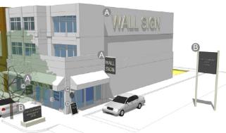
Figure 10-1 Sign Types
This figure depicts examples of various sign types listed in Table 10-1.
The following sign types are distinguished for the purposes of the sign requirements in this section:
|
|
Type |
Description |
|
|---|---|---|---|
|
A |
Wall Sign |
A sign painted, printed or attached to the exterior surface of a building, awning, canopy or other fixed building surface in a permanent manner with a scale and design legible to vehicles in the public right-of-way or pedestrians at a distance from the building. |
|
|
B |
Freestanding Sign |
A detached sign that is mounted to the ground independent from any building with a scale and design legible primarily to vehicles in the public right-of-way. Freestanding signs encompass two specific sign types: |
|
|
Monument Sign: |
A type of freestanding sign mounted on an enclosed, solid base or ornamental surface structure. |
||
|
Pole Sign: |
A type of freestanding sign constructed on one or more columns, poles or similar structures so the bottom edge of the sign surface is elevated above the ground. |
||
|
C |
Pedestrian Sign |
A sign with a design and scale to be legible to pedestrians in front of or immediately adjacent to the building, or to be legible to individuals internal to a site containing multiple buildings. Pedestrian signs may be located in a permanent manner hanging below a canopy or awning, projecting from a wall, mounted on a wall, door or window, or freestanding. |
|
|
D |
Temporary Sign |
A portable sign which is not permanently embedded in the ground or permanently affixed to a building or structure, and designed or intended to be used for a brief period of time. Does not include permanent signs with temporary or changeable messages. |
|
|
E |
Internal Ground Sign |
A sign with a design and scale to be legible to pedestrians or vehicles navigating the internal portions of a site. |
|
(Ord. 2518 § 2 (LDC § 10.03))
17.10.040 Sign Allowances
The following sign allowances apply to zoning districts or groups of zoning districts as the basic standard. Other restrictions in this section, or other regulations, may operate to further reduce the basic sign allowances within each zoning district.
A. Ancillary Signs. Signs supporting a principal or accessory use located on the same property are subject to the allowances in Table 10-2.
|
|
Residential, Agriculture and REC Districts |
C-O, CO-A and C-1 |
C-2, C-3, M-1 and M-2 |
|---|---|---|---|
|
Wall Signs |
For permitted principal nonresidential or multi-family uses: • Number – 2 signs per facade • Total Area Allowance – 5% of facade area maximum • Size – 24 s.f. per sign maximum |
• Number – 1 sign per tenant with exterior entrance (multi-tenant building); otherwise 3 signs per facade maximum • Total Area Allowance – 1.5 s.f. per each 1 linear foot of building frontage • Size – 32 s.f. per sign maximum |
• Number – 2 signs per tenant with exterior entrance (multi-tenant building); otherwise 4 signs per facade maximum • Total Area Allowance – 10% of facade area maximum |
|
Freestanding Signs |
For permitted nonresidential uses, or any residential project over 5 acres: • Number – 1 monument sign per street frontage for nonresidential uses OR per entrance for residential projects over 5 acres • Size – 24 s.f. per sign maximum at the minimum of 10' from property line; additional 8 s.f. per each additional 10' setback, to maximum of 48 s.f. per sign • Height – Monument design required; 6' high maximum Exception: Any residential project more than 10 acres may allocate this allowance into multiple signs, 8 s.f. or less, provided it is part of a streetscape plan/public amenity program with signs integrated into streetscape structures in common areas at intersections throughout neighborhoods. |
• Number – 1 sign per lot • Size – 25 s.f. per sign maximum • Height – Monument design required; 6' high maximum • Setback – 10' minimum setback from all right-of-way and lot lines |
• Number – 1 sign per each 200' of street frontage; maximum of 3 signs per lot • Separation – At least 100' between signs • Total Area Allowance – 1 s.f. per each 2 linear feet of street frontage • Size – 25 s.f. per sign maximum at the minimum of 10' from property line; additional 10 s.f. per each additional 5' setback, to maximum of 65 s.f. per sign • Height – Monument design required; 6' high maximum; and an additional 2' in height for each additional 5' setback up to 15' maximum height • Setback – 10' minimum setback from all right-of-way and lot lines Exception: Signs within 1,000' of the interstate may be pole signs up to 75' high maximum, and up to 300 s.f., per sign maximum if used in lieu of one other wall or freestanding sign. |
|
Temporary Signs |
• Freestanding: ◦ Total Area Allowance – 1 s.f. per each 5 linear feet of street frontage ◦ Size – 9 s.f. per sign maximum; 24 s.f. for lots 5 acres or more ◦ Height – 6' high maximum ◦ Separation – At least 25' between signs • Wall: ◦ Number – 2 signs per facade ◦ Total Area Allowance – 5% of facade area maximum ◦ Size – 8 s.f. per sign maximum • Total combined display time 90 days per calendar year per lot Exemption from permit: 4 s.f. per sign maximum, but still counts to total area allowance and must meet all other temporary standards. |
• Freestanding: ◦ Total Area Allowance – 1 s.f. per each 5 linear feet of street frontage ◦ Size – 32 s.f. per sign maximum ◦ Height – 6' high maximum within the right-of-way and within 10' of the right-of-way; if setback is greater than 10' from the right-of-way, an additional 2' in height for each additional 5' setback up to 15' maximum height ◦ Separation – At least 70' between signs • Wall: ◦ Number – 2 signs per facade ◦ Total Area Allowance – 5% of facade area maximum ◦ Size – 32 s.f. per sign maximum • Total combined display time 90 days per calendar year per lot Exemption from permit: 4 s.f. per sign maximum, but still counts to total area allowance and must meet all other temporary standards. Exception: Temporary signs may exceed these limits if it is in place of any other permitted sign to allow for a new business during an interim period not to exceed 90 days, and subject to all other limits of the substituted sign type. |
|
|
Pedestrian Sign |
For permitted nonresidential use: • Number – 1 sign per each public entrance • Height – 6' high maximum and within 30' of entrance if mounted on the ground • Size – 6 s.f. per sign maximum |
• Number and Size – 1 sign per each public building entrance; 8 s.f. per sign maximum; and within 20 feet of entrance AND • Number and Size – 1 sign per each 25 linear feet of building frontage; 6 s.f. per sign maximum Exemption: Portable pedestrian signs or any pedestrian sign mounted on a building that projects into the right-of-way are exempt from right-of-way prohibition in C-1 district AND on any street designed to activity street specs per subdivision design standards. Portable pedestrian signs shall meet GMC 17.10.060(B). |
|
|
Internal Ground Sign |
Not applicable |
• Number – 1 sign per each 5,000 square feet of lot • Size – 4 s.f. per sign maximum; up to 12 s.f. per sign for lots or parcels over 5 acres and if set back at least 50' from public right-of-way or lot lines • Height – 3' high maximum; up to 5' high maximum for signs on lots or parcels over 5 acres and if set back at least 50' from the right-of-way or lot lines |
|
B. Principal Use Signs. Signs are a principal use of property when the sign is not considered to be ancillary to another principal or accessory use on the same property and are subject to the allowances in Table 10-3 and the standards listed below.
|
|
Residential, Agriculture and REC Districts |
C-O, CO-A, C-1 and C-2 |
C-3, M-1 and M-2 |
|---|---|---|---|
|
Freestanding Signs |
Not Allowed |
Not Allowed |
• Location – On parcels abutting the I-35 right-of-way only; not allowed adjacent to an I-35 on-ramp or off-ramp for the extended distance of 500 feet prior to the beginning of the deceleration lane or 500 feet beyond the end of the acceleration lane of I-35 on/off ramps. • Vehicular Access – Must be provided from the nearest public road right-of-way (other than I-35) and constructed with a dust-free surface to a standard that accommodates emergency vehicle access to the sign location. • Separation – ◦ For nonelectronic/digital/LED signs 600 feet of separation distance from any other principal use sign located on either side of I-35 as measured along the centerline of the I-35 right-of-way from a point opposite any edge of a principal use sign and perpendicular to the centerline of I-35. ◦ For electronic/digital/LED signs 1,000 feet of separation distance from any other principal use sign located on either side of I-35 as measured along the centerline of the I-35 right-of-way from a point opposite any edge of a principal use sign and perpendicular to the centerline of I-35. • Total Area Allowance – 750 total square feet of sign display area facing the same direction. • Size – Height of sign face 15 feet or less; width of sign face 50 feet or less. • Height – Overall height 30 feet or less; conditional use permit required for heights greater than 30 feet up to 50 feet and for vertical stacking of signs. • Setback – 15 feet from the I-35 right-of-way; for nonelectronic/digital/LED signs 500 feet from any residentially zoned property; for electronic/digital/LED signs 1,000 feet from any residentially zoned property. |
Standards Applicable to Principal Use Signs (in addition to other sections of the Gardner Land Development Code).
1. Sign Type.
a. Monument. Subject to the standards identified in GMC 17.10.060(A).
b. Pole. Subject to the standards identified in GMC 17.10.060(F).
2. Lighting.
a. No flashing, intermittent or moving lights.
b. Direct/indirect lighting sources shall be shielded in a manner that directs light to the sign face only, prevents the light source from being visible when looking at the sign and prevents glare.
c. Electronic/digital/LED signs must display a static image for a minimum of 10 seconds between changes in display and no more than two seconds for transitions. No scrolling, flashing or animated transitions shall occur. Automatic dimming controls shall limit the illumination to no more than 500 nits at the sign surface at night or during low light times, and no more than 5,000 nits at the brightest daylight period.
3. Construction/Maintenance.
a. An initial building/sign permit is required and plans provided with applications for permitting such sign shall be certified by a licensed engineer registered in the State of Kansas.
b. Construction shall be in accordance with industry-wide standards and the adopted building regulations of the City of Gardner.
c. Maintenance activities shall ensure that the sign is structurally sound and in good condition and that the property is maintained in compliance with the adopted regulations of the City of Gardner.
d. Sign permits for such signs shall be renewed every five years through the filing of a sign permit renewal application and a certified inspection report provided by a licensed engineer registered in the State of Kansas verifying the sign is structurally sound and in good condition.
4. Conditional Use Permit (CUP) Required. Principal use sign applications with the following characteristics are subject to the CUP review and approval process outlined in GMC 17.03.050:
a. Height above 30 feet to 50 feet maximum.
b. Vertical stacked signs.
5. The sign shall be subject to meeting all other applicable state and federal regulations, including but not limited to the Kansas Highway Beautification Highway Advertising Control Act of 1972, K.S.A. 68-2231 et seq., as amended, and the United States Highway Beautification Act of 1965, 23 U.S.C. § 133, as amended. Each sign shall be permitted by the State of Kansas in accordance with K.S.A. 68-2236, as amended. In the event that an application for placement of a principal use sign is made prior to the applicant obtaining a permit from the State, any approval shall be conditioned upon the applicant subsequently obtaining a State permit. (Ord. 2722 § 3; Ord. 2584 § 1; Ord. 2518 § 2 (LDC § 10.04))
17.10.050 Standards Applicable to All Signs
A. No sign shall be attached to any public utility pole or shall be installed within the right-of-way of a public road or street, except as permitted by the applicable road authority or where specifically exempt from the right-of-way prohibition by this chapter.
B. No sign shall be erected without the property owner’s permission.
C. No sign shall imitate or resemble government signs for traffic direction or any other public safety symbol.
D. No sign shall be placed in any sight triangle applicable to public streets, internal access streets, or driveway access points using the sight distance provisions of GMC 17.04.010(D).
E. No sign shall be placed on any vehicle or trailer, when such vehicle or trailer is placed or parked visible from the right-of-way, and the primary purpose of the sign is to deviate from the standards or criteria of this chapter.
F. No sign attached to any building shall extend vertically above the highest portion of the roof line or parapet, whichever is less.
G. Any sign projecting over a walkway or other active area in front of a building or other active area where people may walk shall maintain at least eight-foot vertical clearance.
H. No sign shall include balloons, streamers, pennants or other air-activated elements and animated elements, whether animated by mechanical, electrical, or environmental means, except as authorized through any temporary use or special event permit. This limit shall not apply to pedestrian signs, provided any animated element shall apply to the overall pedestrian sign allowances.
I. Any illumination shall be designed to eliminate negative impacts on surrounding rights-of-way and properties. The light from an illuminated sign shall not flash or oscillate, or create a negative impact on residential uses in direct line-of-sight to the sign.
J. External light sources shall be directed and shielded to limit direct illumination of any object other than the sign. (Ord. 2722 § 4; Ord. 2518 § 2 (LDC § 10.05))
17.10.060 Standards Applicable to Specific Sign Types
A. Monument Signs.
1. Monument signs shall be located within a landscape area as required by the site design standards of this Code, or shall include at least three feet of landscape area on all sides of the sign base.
2. Monument signs shall have a base at least 75 percent of the width of the widest part of the sign.
3. The base and sign shall include ornamental architectural details and materials that complement the overall design of the site and building.
B. Portable Pedestrian Signs. Portable pedestrian signs (“A frame,” “sandwich board” or “T-frame”) may be placed in the public right-of-way for retail and service uses in the C-1 district, provided:
1. The sign is placed within 20 feet of the main entrance of the building.
2. The sign is no larger than eight square feet and no taller than four feet high.
3. The sign is placed on or near a sidewalk, and maintains at least six feet clear passage for pedestrians on the sidewalk, and is otherwise not put in any location that creates visual obstructions or safety hazards for users of the right-of-way.
4. The sign is removed and brought inside during nonbusiness hours.
5. The sign is designed with durable materials and quality aesthetics for use on a recurring basis. Although changeable copy can be included as part of the design, such as chalkboards, signs designed as “temporary signs” are not eligible as portable pedestrian signs, and the allowance for signs in the right-of-way specifically does not apply to any temporary sign.
C. Electronic Message Signs. Electronic message signs are subject to the following additional limitations:
1. Limited to C-2, C-3, M-1 and M-2 districts, or for a permitted institutional or civic use in all other districts.
2. Limited to one per lot.
3. The visible sign face shall be set back at least 250 feet from any adjacent residentially zoned property.
4. The electronic portion shall be limited to no more than 50 percent of the allowable sign area.
5. Automatic dimming controls shall limit the illumination to no more than 500 nits at the sign surface at night or during low light times, and no more than 5,000 nits at the brightest daylight period.
6. Only static display is permitted with at least 10 seconds between changes in display and no more than two seconds for transitions. No scrolling, flashing or animated transitions shall occur.
D. Changeable Message. Any sign may be designed with a manual changeable message portion, provided the changeable portion is limited to no more than 50 percent of the sign area.
E. Temporary Signs. Temporary signs are subject to the following additional limitations:
1. It shall be the responsibility of the person who causes the temporary sign to be erected to see that the temporary sign placed with the permission of the property owner is removed when the display time has exceeded the applicable regulatory time limit.
2. Temporary signs shall not be illuminated or painted with a light-reflecting paint.
3. Temporary signs shall be constructed of rigid material, and securely anchored so as not to pose a distraction or hazard to drivers. Nonrigid materials (such as banners) which are securely mounted on a wall, rigid backing material, or completely framed without sagging or flapping may be used as a temporary sign if set back at least 30 feet from the pavement edge of the fronting roadway.
4. The Director shall be authorized to extend the duration of display time for temporary signage pertaining to the sale of that property once per calendar year, until such time as the property is sold.
5. The Director shall be authorized to require the removal of any temporary sign that pertains to an expired event.
F. Pole Signs.
1. Pole signs shall be located within a landscape area that is at least equal to the area of the sign, and which is in addition to any landscape area required by the site design standards of this Code.
2. The additional landscape area shall be included in the calculation for minimum planting specifications and planted with materials required by the landscape section. (Ord. 2584 § 1; Ord. 2518 § 2 (LDC § 10.06))
17.10.070 Planned Districts
Projects proposed and approved through the planned development process may propose a specific sign package. The sign package shall be based on the intent, types of signs, and standards of this chapter, but the City may approve deviations to these standards through the review process and criteria of planned development districts. Any planned development not proposed and approved with a sign plan noting specific deviations shall be subject to these standards. (Ord. 2518 § 2 (LDC § 10.07))