


Chapter 8.24
FLOOD DAMAGE PREVENTION1
Sections:
8.24.010 Statutory authorization.
8.24.030 Statement of purpose.
8.24.040 Methods of reducing flood losses.
8.24.060 Lands to which this chapter applies.
8.24.070 Basis for establishing the areas of special flood hazard.
8.24.080 Coordination with the State of Oregon Building Codes Division Specialty Codes.
8.24.090 Requirement for floodplain development permit.
8.24.110 Warning and disclaimer of liability.
8.24.120 Designation of the local floodplain administrator.
8.24.130 Duties and responsibilities of the floodplain administrator.
8.24.150 Substantial damage and substantial improvement determination.
8.24.160 Watercourse alterations.
8.24.170 Requirement to submit new technical data.
8.24.180 Nonconversion of enclosed areas below the lowest floor.
8.24.190 Site improvements and subdivisions.
8.24.200 Development in regulatory floodways.
8.24.210 Development in zones with BFEs but no regulatory floodway.
8.24.220 Development in zones without base flood elevations.
8.24.230 Stream setback requirements.
8.24.250 Floodplain development standards for construction.
8.24.270 Interpretations and variances.
8.24.280 Penalties for noncompliance.
8.24.300 Abrogation and greater restrictions.
8.24.010 Statutory authorization.
The State of Oregon has in ORS 197.175 delegated the responsibility to local governmental units to adopt floodplain management regulations designed to promote the public health, safety, and general welfare of its citizenry. Therefore, the city ordains and sets out the provisions of this chapter. (Ord. 2079 §1, 2021; Ord. 1947 §1(part), 2011).
8.24.020 Findings of fact.
A. The flood hazard areas of the city are subject to periodic inundation which results in loss of life and property, health and safety hazards, disruption of commerce and governmental services, extraordinary public expenditures for flood protection and relief, and impairment of the tax base; all of which adversely affect the public health, safety, and general welfare.
B. These flood losses are caused by structures in flood hazard areas which are inadequately elevated, floodproofed, or otherwise unprotected from flood damages, and the cumulative effect of obstructions in flood hazard areas, which increases flood heights and velocities, and when inadequately anchored, damage uses in other areas.
C. The city of Central Point has the primary responsibility for planning, adoption and enforcement of land use regulations to accomplish proper floodplain management. (Ord. 1947 §1(part), 2011).
8.24.030 Statement of purpose.
It is the purpose of this chapter to promote the public health, safety, and general welfare; reduce the annual cost of flood insurance; and to minimize public and private losses due to flood conditions in specific areas by provisions designed to:
A. Protect human life and health;
B. Minimize expenditure of public money on costly flood damage and control projects;
C. Minimize the need for rescue and relief efforts associated with flooding and generally undertaken at the expense of the general public;
D. Minimize unnecessary disruption of commerce, access and public service during times of flood;
E. Minimize damage to public facilities and utilities such as water, sanitary sewer, storm drain and gas mains; electric, telephone, and television cable lines; and streets, bridges, and other appurtenances which are located in areas of special flood hazard;
F. Help maintain a stable tax base by providing for the sound use and development of flood-prone areas;
G. Ensure that potential buyers are notified that property is in an area of special flood hazard;
H. Ensure that those who occupy the areas of special flood hazard assume responsibility for their actions;
I. Manage the alteration of flood hazard areas, stream channels and shorelines to minimize the impact of development on the natural and beneficial functions of the floodplain;
J. Participate in and maintain eligibility for flood insurance and disaster relief. (Ord. 2079 §1, 2021; Ord. 1947 §1(part), 2011).
8.24.040 Methods of reducing flood losses.
In order to accomplish its purposes, this chapter includes methods and provisions to:
A. Restrict or prohibit uses which are dangerous to health, safety, and property due to water or erosion hazards, or which increase flood heights, velocities, or erosion;
B. Require development that is vulnerable to floods, including structures and facilities necessary for the general health, safety and welfare of citizens, to be protected against flood damage at the time of initial construction;
C. Control filling, grading, dredging and other development which may increase or modify flood damage or erosion;
D. Prevent or regulate the construction of flood barriers that will unnaturally divert flood waters or that may increase flood hazards to other lands;
E. Preserve and restore natural floodplains, stream channels and natural protective barriers which carry and store flood waters; and
F. Coordinate with and supplement provisions of State of Oregon Specialty Codes Enforced by the State of Oregon Building Codes Division. (Ord. 1947 §1(part), 2011).
8.24.050 Definitions.
Unless specifically defined below, words or phrases used in this chapter shall be interpreted so as to give them the meaning they have in common usage and to give this chapter its most reasonable application.
“Accessory structure” means a structure on the same or adjacent parcel as a principal structure, the use of which is incidental and subordinate to the principal structure.
“Appeal” means a request for review of the floodplain administrator’s interpretation of provisions of this chapter.
“Area of shallow flooding” means a designated AO or AH zone on the flood insurance rate map (FIRM) with base flood depths ranging from one to three feet, and/or where a clearly defined channel does not exist, where the path of flooding is unpredictable and indeterminate, and where velocity flow may be evident. AO zones are characterized as having sheet flow, and AH zones indicate ponding. For both AO and AH zones, adequate drainage paths are required around structures on slopes to guide floodwaters around and away from proposed structures.
“Area of special flood hazard” means the land in the floodplain within a community subject to a one percent or greater chance of flooding in any given year. It is shown on the flood insurance rate map (FIRM) as zone A, AO, AH, A1-30, AE, A99, AR. Also known as the special flood hazard area (SFHA).
“Base flood” means the flood having a one percent chance of being equaled or exceeded in any given year.
“Base flood elevation (BFE)” means the water surface elevation to which floodwater is anticipated to rise during the base flood. The BFE is depicted on the flood insurance rate map (FIRM) to the nearest foot and in the flood insurance study (FIS) to the nearest tenth of a foot.
“Basement” means any area of a building having its floor subgrade (below ground level) on all sides.
“Below-grade crawlspace” means an enclosed area below the BFE in which the interior grade is not more than two feet below the lowest adjacent exterior grade and the height, measured from the interior grade of the crawlspace to the top of the crawlspace foundation, does not exceed four feet at any point. Below-grade crawlspaces are allowed subject to the conditions found in FEMA Technical Bulletin 11-01 and in Section 8.24.250(F)(3).
“City” means the city of Central Point.
“Conditional letter of map revision (CLOMR)” means a formal review and comment by FEMA as to whether a proposed project complies with minimum National Flood Insurance Program (NFIP) floodplain management criteria. A CLOMR does not amend or revise effective flood insurance rate maps, flood boundary and floodway maps or flood insurance studies, nor does a CLOMR constitute a formal project approval by the city.
“Critical facility” or “essential facility” means a facility that is critical for the health and welfare of the population and is especially important following hazard events. “Critical facilities” or “essential facilities” include:
1. Hospitals and other medical facilities having surgery and emergency treatment areas;
2. Fire and police stations;
3. Tanks or other structures containing, housing or supporting water or fire-suppression materials or equipment required for the protection of essential or hazardous facilities or special occupancy structures;
4. Emergency vehicle shelters and garages;
5. Structures and equipment in emergency preparedness centers;
6. Standby power generating equipment for essential facilities; and
7. Structures and equipment in government communication centers and other facilities required for emergency response.
“Datum” means the vertical datum. The vertical datum is a base measurement point (or set of points) from which all elevations are determined. Historically, that common set of points has been the National Geodetic Vertical Datum of 1929 (NGVD 1929). The vertical datum currently adopted by the federal government as a basis for measure heights is the North American Vertical Datum of 1988 (NAVD 1988).
“Development” means any manmade change to improved or unimproved real estate, including but not limited to buildings or other structures, mining, dredging, filling, grading, paving, excavation, or drilling operations; or storage of equipment and materials located within the area of special flood hazard. Exemptions to the definition of development, for the purpose of administering this chapter, include:
1. Signs, markers, aids, etc., placed by a public agency to serve the public provided the encroachment in the special flood hazard area is no larger than a standard utility pole; and
2. Residential gardens; provided, that they do not result in unauthorized, substantial alteration of topography; and provided, that gardening methods do not include the use or application of pesticides, herbicides, fertilizers or other toxic materials.
“DFIRM” means digital flood insurance rate map. It depicts flood risk and zones and flood risk information. The DFIRM presents the flood risk information in a format suitable for electronic mapping applications.
“Elevated building” means, for insurance purposes, a nonbasement building that has its lowest elevated floor raised above ground level by foundation walls, shear walls, posts, piers, pilings or columns.
“Encroachment” means the advancement or infringement of uses, fill, excavation, buildings, permanent structures or other development into a floodway, which may impede or alter the flow capacity of a floodplain.
Essential Facility. See “Critical facility.”
“FEMA” means the Federal Emergency Management Agency.
“Flood” or “flooding” means a general and temporary condition of partial or complete inundation of normally dry land areas from:
1. The overflow of inland or tidal waters; and/or
2. The unusual and rapid accumulation of runoff of surface waters from any source.
“Flood insurance rate map (FIRM)” means the official map of a community issued by FEMA delineating the areas of special flood hazard and/or risk premium zones applicable to the community.
“Flood insurance study (FIS)” means the official report provided by FEMA evaluating flood hazards and containing flood profiles, regulatory floodway boundaries and water surface elevations of the base flood.
“Floodway” or “regulatory floodway” means the channel of a river or other watercourse and the adjacent land areas that must be reserved in order to discharge the base flood without cumulatively increasing the water surface elevation more than a designated height.
“Functionally dependent use” means a use which cannot perform its intended purpose unless it is located or carried out in close proximity to water. The term includes only docking facilities, port facilities that are necessary for the loading and unloading of cargo or passengers, and ship building and ship repair facilities, and does not include long-term storage or related manufacturing facilities.
“Highest adjacent grade” means the highest natural elevation of the ground surface prior to construction next to the proposed walls of a structure.
“Historic structure” means a structure that is:
1. Listed individually in the National Register of Historic Places (a listing maintained by the U.S. Department of the Interior) or preliminarily determined by the Secretary of the Interior as meeting the requirements for individual listing on the National Register;
2. Certified or preliminarily determined by the Secretary of the Interior as contributing to the historical significance of a registered historic district or to a district preliminarily determined by the Secretary to qualify as a registered historic district;
3. Individually listed on a state inventory of historic places and determined as eligible by states with historic preservation programs which have been approved by the Secretary of the Interior; or
4. Individually listed on a local inventory of historic places and determined as eligible by communities with historic preservation programs that have been certified either:
a. By an approved state program as determined by the Secretary of the Interior; or
b. Directly by the Secretary of the Interior in states without approved programs.
“Letter of map change (LOMC)” means an official FEMA determination by letter, to amend or revise effective flood insurance rate maps and flood insurance studies. LOMCs are issued in the following categories:
1. “Letter of map amendment (LOMA)” means a revision based on technical data showing that a property was inadvertently included in a designated special flood hazard area. A LOMA amends the current effective flood insurance rate map and establishes that a specific property or structure is not located in a special flood hazard area;
2. “Letter of map revision (LOMR)” means a revision based on technical data showing, due to human-made alterations, changes to flood zones, flood elevations, or floodplain and regulatory floodway delineations. One common type of LOMR, a LOMR-F, is a determination that a structure or parcel has been elevated by fill above the BFE and is excluded from the special flood hazard area.
“Lowest floor” means the lowest floor of the lowest enclosed area, including basement. An unfinished or flood-resistant enclosure (used solely for parking of vehicles, building access or storage) in an area other than a basement area, is not considered a building’s lowest floor; provided, that such enclosure is not built so as to render the structure in violation of the applicable nonelevation design requirements found in Section 8.24.250(F)(2) and (3).
“Manufactured dwelling” or “manufactured home” means a structure, transportable in one or more sections, which is built on a permanent chassis and is designed for use with or without a permanent foundation when attached to the required utilities. The term “manufactured home” does not include a recreational vehicle.
“New construction” means structures for which the start of construction commenced on or after the effective date of the adopted flood damage prevention requirements codified in this chapter, including subsequent substantial improvements to the structure.
“NFIP” means National Flood Insurance Program.
“Reasonably safe from flooding” means development is designed and built to be safe from flooding based on consideration of current flood elevation studies, historical data, high water marks and other reliable data known to the community. In unnumbered A zones where flood elevation information is not available and cannot be obtained by practical means, “reasonably safe from flooding” means that the lowest floor is at least two feet above highest adjacent grade.
“Recreational vehicle” means a vehicle that is:
1. Built on a single chassis;
2. Four hundred square feet or less when measured at the largest horizontal projection;
3. Designed to be self-propelled or permanently towable by a light duty truck; and
4. Not primarily designed for use as a permanent dwelling, but as temporary living quarters for recreational, camping, travel or seasonal use.
“Start of construction” means the date the development permit (which includes development, public works and building permits) was issued, provided the actual start of construction, repair, reconstruction, placement or other substantial improvement was within one year of the permit issuance date. The “actual start of construction” means either the first placement of permanent construction of a structure on a site, such as the pouring of slab or footings, the installation of piles, the construction of columns, or any work beyond the stage of excavation or the placement of a manufactured home on a foundation or blocks. Permanent construction does not include land preparation, such as clearing, grading and filling; the installation of streets and/or walkways; excavation for a basement, footings, piers or foundations; the erection of temporary forms; or the installation of the property or accessory buildings (i.e., garages or sheds) not occupied as dwelling units or which are not part of the main structure. For a substantial improvement, the “actual start of construction” means the first alteration of any wall, ceiling, floor or other structural part of a building, whether or not that alteration affects the external dimensions of the building.
“Structure” means a walled and roofed building, manufactured dwelling, a modular or temporary building, or liquid storage tank that is principally above ground.
“Substantial damage” means damage of any origin sustained by a structure on at least two separate occasions during a ten-year period whereby the cost of restoring the structure for which the cost of repairs to its before-damaged condition would equal or exceed fifty percent of the market value of the structure before the damage occurred.
“Substantial improvement” means any repair, construction, or improvement of a structure, the cost of which equals or exceeds fifty percent of the market value of the structure within the course of a ten-year period either:
1. Before the improvement or repair is started; or
2. If the structure has been damaged and is being restored, before the damage occurred.
For the purposes of this definition, “substantial improvement” is considered to occur when the first alteration of any wall, ceiling, floor, or other structural part of the building commences, whether or not that alteration affects the external dimensions of the structure. The term does not, however, include:
a. Any project for improvement of a structure to comply with existing state or local health, sanitary or safety code specifications which are solely necessary to assure safe living conditions; or
b. Any alteration of a structure listed on the National Register of Historic Places or the Oregon State Inventory of Historic Places.
“Variance” means a grant of relief from the requirements of this chapter which permits construction in a manner that would otherwise be prohibited by this chapter.
“Violation” means the failure of a structure or other development to be fully compliant with the community’s floodplain management regulations. A structure or other development without evidence of compliance, such as a FEMA elevation certificate, floodproofing certificate or other certification, is presumed to be in violation until such time as that documentation is provided.
“Watercourse” means a lake, river, creek, stream, wash, arroyo, channel or other topographic feature in, on, through, or over which water flows at least periodically.
“Water surface elevation” means the height, in relation to a specified datum, of floods of various magnitudes and frequencies in the floodplains of riverine areas. (Ord. 2079 §1, 2021; Ord. 1947 §1(part), 2011).
8.24.060 Lands to which this chapter applies.
A. Applicability. This chapter shall apply to all areas of special flood hazard within the jurisdiction of the city. All development within special flood hazard areas is subject to the terms of this chapter and other applicable regulations. Nothing in this chapter is intended to allow uses or structures that are otherwise prohibited by the zoning regulations or specialty codes.
B. Community Boundary Alterations. The floodplain administrator shall notify the Federal Insurance Administrator in writing whenever the boundaries of the community have been modified by annexation or the community has otherwise assumed authority or no longer has authority to adopt and enforce floodplain management regulations for a particular area, to ensure that all flood hazard boundary maps (FHBM) and flood insurance rate maps (FIRM) accurately represent the community’s boundaries. Include within such notification a copy of a map of the community suitable for reproduction, clearly delineating the new corporate limits or new area for which the community has assumed or relinquished floodplain management regulatory authority. (Ord. 2079 §1, 2021; Ord. 1947 §1(part), 2011).
8.24.070 Basis for establishing the areas of special flood hazard.
The areas of special flood hazard identified by the Federal Emergency Management Agency in The Flood Insurance Study (FIS) for Jackson County, Oregon and Incorporated Areas, dated May 3, 2011, with accompanying flood insurance rate maps (FIRM) and digital flood insurance rate maps (DFIRM) are adopted by reference and declared a part of this chapter. The FIS and FIRM are on file at Central Point City Hall located at 140 South 3rd Street, Central Point, Oregon.
The floodplain administrator or designee may also identify additional areas of special flood hazard which are not identified by FEMA, but have been identified as being areas of special flood hazard due to their proximity to named or unnamed ditches, creeks, streams, rivers, or channels; or that have been identified as areas of special flood hazard based on historical events or occurrences. (Ord. 1947 §1(part), 2011).
8.24.080 Coordination with the State of Oregon Building Codes Division Specialty Codes.
Pursuant to the requirement established in ORS Chapter 455 that the city of Central Point administer and enforce the State of Oregon Specialty Codes, the city council of Central Point does hereby acknowledge that the specialty codes contain certain provisions that apply to the design and construction of buildings and structures located in areas of special flood hazard. Therefore, this chapter is intended to be administered and enforced in conjunction with the specialty codes. (Ord. 1947 §1(part), 2011).
8.24.090 Requirement for floodplain development permit.
A. A floodplain development permit shall be required prior to initiating development activities in any special flood hazard areas as established in Section 8.24.070. The permit shall be for all improvements or structures (including manufactured homes and fences, as set forth in Sections 8.24.050, 8.24.250 and 8.24.260), and for all development including fill and other activities, also set forth in Section 8.24.260. Floodplain development permits shall be subject to the review procedures based on the type of development activity proposed, as set forth below:
1. Section 17.05.200, Type I procedure (administrative), applies to the following floodplain development projects:
a. Site improvements and construction, including but not limited to new construction, additions, remodels, repairs and renovations located outside a regulatory floodway;
b. Development activities located outside the special stream setback area established in Section 17.60.090;
c. Development activities that do not require a conditional letter of map revision (CLOMR) or letter of map revision pursuant to Section 8.24.170(A) and (B);
d. Water dependent uses, such as bridges, culverts or other capital improvements identified in the city’s capital improvement program that do not cause any rise in the base flood elevation per Section 8.24.200(A);
e. Stream bank stabilization projects that utilize vegetative planting techniques and contribute no fill or material other than vegetation to the stream channel, stream bank or surrounding area;
f. Bridge or culvert replacement projects deemed necessary by the floodplain administrator or designee to address immediate concerns for life, safety, health and/or the general welfare of the community; provided, that the following conditions are met:
i. The applicant is responsible for providing evidence necessary to support determination of public emergency;
ii. The bridge or culvert replacement is located along a similar or parallel alignment and contributes no additional material to the floodway;
iii. The bridge or culvert replacement project is consistent with any applicable hazard mitigation project actions identified in the Central Point Hazard Mitigation Plan; and
iv. The applicant provides certification of floodplain impacts and encroachment analysis for any permanent bridge or culvert placement at the time of application and includes:
(A) Impacts to the BFE;
(B) Impacts to the base floodplain boundaries; and
(C) Identification of any insurable structures within the base floodplain.
2. Section 17.05.300, Type II procedure (administrative), applies to floodplain development applications for minor partitions defined in Section 16.08.010(14).
3. Section 17.05.400, Type III procedure (quasi-judicial), applies to the following floodplain development projects:
a. Floodway development proposals except water dependent uses subject to the Type I review procedures per subsection (A)(1)(d) of this section;
b. Development proposals that require a conditional letter of map revision (CLOMR) and/or letter of map revision (LOMR) pursuant to Section 8.24.170(A) and (B);
c. Stream bank stabilization projects that utilize methods other than vegetative plantings to achieve shoreline stabilization and safety;
d. Projects requesting a variance to the provisions of this chapter. (Ord. 2034 §1(part), 2017; Ord. 1947 §1(part), 2011).
8.24.100 Interpretation.
In the interpretation and application of this chapter, all provisions shall be:
A. Considered as minimum requirements;
B. Liberally construed in favor of the governing body; and
C. Deemed neither to limit nor repeal any other powers granted under federal, state, or local laws, ordinances, rules, or statutes, including the state building code. (Ord. 1947 §1(part), 2011).
8.24.110 Warning and disclaimer of liability.
The degree of flood protection required by this chapter is considered reasonable for regulatory purposes and is based on scientific and engineering considerations. Larger floods can and will occur on rare occasions. Flood heights may be increased by manmade or natural causes. This chapter does not imply that land outside the areas of special flood hazards or uses permitted within such areas will be free from flooding or flood damages. This chapter shall not create liability on the part of the city, any officer or employee thereof, or FEMA, for any flood damages that result from reliance on this chapter or any administrative decision lawfully made under this chapter. (Ord. 1947 §1(part), 2011).
8.24.120 Designation of the local floodplain administrator.
The city manager or designee is hereby appointed as the floodplain administrator who is responsible for administering and implementing the provisions of this chapter. (Ord. 1969 §1(part), 2013; Ord. 1947 §1(part), 2011).
8.24.130 Duties and responsibilities of the floodplain administrator.
Duties of the floodplain administrator shall include, but not be limited to, the following:
A. Review all proposed development to determine whether it will be located in areas of special flood hazard or other flood-prone areas;
B. Review applications for new development or modifications of any existing development located in areas of special flood hazard for compliance with the requirements of this chapter;
C. Interpret flood hazard area boundaries, provide available flood hazard information, and provide BFEs where they exist;
D. Review proposed development to assure that necessary permits have been obtained from government agencies from which approval is required by federal or state law. Copies of such permits shall be maintained on file;
E. Review all development permit applications to determine if the proposed development is located in the regulatory floodway and, if so, ensure that the encroachment standards of Section 8.24.200 are met;
F. When BFE data or floodway data have not been established pursuant to Section 8.24.070, then the floodplain administrator shall obtain, review and reasonably utilize any BFE and floodway data available from a federal, state or other authoritative source in order to administer the provisions of this chapter;
G. When BFEs or other engineering data are not available from an authoritative source, the floodplain administrator shall require BFEs to be developed in accordance with Section 8.24.190(E) or take into account the flood hazards, to the extent they are know, to determine whether a proposed building site or subdivision will be reasonably safe from flooding;
H. Where a determination is needed of the exact location of boundaries of the areas of special flood hazard, such as when there appears to be a conflict between a mapped boundary and actual field conditions, the floodplain administrator shall make the interpretation. Any person contesting the location of the boundary may appeal the determination subject to the process identified in Section 8.24.300;
I. Issue floodplain development permits when the provisions of this chapter have been met, or deny the same in the event of noncompliance;
J. Coordinate with the building official to assure that the applications for building permits comply with the requirements of this chapter;
K. Obtain, verify and record the actual elevation, in relation to the vertical datum used on the effective FIRM, or highest adjacent grade where no BFE is available, of the lowest floor level, including basement of all new construction or substantially improved buildings and structures;
L. Obtain, verify and record the actual elevation, in relation to the vertical datum used on the effective FIRM, or highest adjacent grade where no BFE is available, to which any new or substantially improved nonresidential buildings or structures have been floodproofed. When floodproofing criteria are utilized for a structure, the floodplain administrator shall obtain certification of design criteria from a registered professional engineer or architect;
M. Ensure that all records pertaining to the provisions of this chapter are permanently maintained in the office of the floodplain administrator and are available for public inspection;
N. Make periodic inspections of areas of special flood hazard to establish that development activities are being performed in compliance with this chapter, and to verify that existing buildings and structures maintain compliance with this chapter;
O. Coordinate with the building official to inspect areas where buildings and structures in areas of special flood hazard have been damaged, regardless of the cause of damage, and notify owners that permits may be required prior to repair, rehabilitations, demolition, relocation or reconstruction of the building or structure; and
P. Make substantial improvement and substantial damage determinations for all structures located in areas of special flood hazard. (Ord. 1947 §1(part), 2011).
8.24.140 Permit procedures.
Application for a floodplain development permit shall be made to the floodplain administrator on forms furnished by the administrator or designee prior to starting development activities. Specifically, the following information is required:
A. Application Stage.
1. Plans in duplicate, drawn to scale with elevations of the project area and the nature, location, dimensions of existing and proposed structures, earthen fill placement, storage of materials or equipment and drainage facilities;
2. Delineation of special flood hazard areas, regulatory floodway boundaries, including BFEs, or flood depth in AO or AH zones where available;
3. For all proposed structures, elevation in relation to the highest adjacent grade and BFE or flood depth in AO or AH zones, of the:
a. Lowest enclosed area, including crawlspace or basement floor;
b. Top of the proposed garage slab, if any; and
c. Next highest floor;
4. Locations and sizes of all flood openings in any proposed building;
5. Elevation to which any nonresidential structure will be floodproofed;
6. Certification from a registered professional engineer or architect that any proposed nonresidential floodproofed structure will meet the floodproofing criteria of the NFIP and specialty codes;
7. Description of the extent to which any watercourse will be altered or relocated as a result of a proposed development;
8. Proof that application has been made for necessary permits from other governmental agencies from which approval is required by federal or state law; and
9. Copies of documentation associated with a CLOMR received from FEMA required pursuant to Section 8.24.170.
B. Construction Stage.
1. For all new construction and substantial improvements, the permit holder shall provide to the floodplain administrator an as-built certification of the floor elevation or floodproofing level immediately after the lowest floor or floodproofing is placed and prior to further vertical construction;
2. Any deficiencies identified by the floodplain administrator shall be corrected by the permit holder immediately and prior to work proceeding. Failure to submit certification or failure to make the corrections shall be cause for the floodplain administrator to issue a stop-work order for the project.
C. Certificate of Occupancy.
1. In addition to the requirements of the building codes pertaining to certificate of occupancy, prior to the final inspection, the owner or authorized agent shall submit the following documentation that has been prepared and sealed by a registered surveyor or engineer for review and approval by the floodplain administrator:
a. For elevated buildings and structures in special flood hazard areas (A zones), a completed FEMA Elevation Certificate (FEMA Form 81-31) that includes the as-built elevation of the lowest floor, including basement or, where no BFE is available, the height above the highest adjacent grade of the lowest floor; and
b. For buildings and structures that have been floodproofed, a FEMA floodproofing certificate (FEMA Form 81-65) that includes the elevation to which the building or structure was floodproofed.
2. Failure to submit certification or failure to correct violations shall be cause for the floodplain administrator to withhold a certificate of occupancy until such deficiencies are corrected.
D. Expiration of Floodplain Development Permit.
1. A floodplain development permit shall expire one hundred eighty days after date of issuance unless the permitted activity has commenced as provided in the definition of “substantial improvement” in Section 8.24.050 and thereafter is pursued until completion;
2. The floodplain administrator or designee shall, upon written request by the applicant or authorized agent and payment of the required fee, grant a written one one-hundred-eighty-day extension of the approval period with the exception that projects with extenuating circumstances may be granted additional extensions as needed; and provided, that:
a. No changes are made to the original application as approved by the city;
b. There have been no changes in the code provisions on which the approval was based. In the case where the plan conflicts with a code provision, the extension shall be either:
i. Denied; or
ii. Re-reviewed at the discretion of the floodplain administrator or designee;
c. The extension request is made prior to the expiration date of the original approved plan; and
d. The application shall be void if the original application expires and no extension has been granted. (Ord. 1947 §1(part), 2011).
8.24.150 Substantial damage and substantial improvement determination.
For application for permits to improve buildings and structures, including additions, repairs, renovations and alterations, the floodplain administrator shall:
A. Estimate the market value, or require the applicant to obtain a professional appraisal of the market value, of the building or structure before the proposed work is performed. When repair of damage is proposed, the market value of the building or structure shall be the market value before the damage occurred;
B. Compare the cost of improvement, the cost to repair the damaged building to its pre-damaged condition, or the combined costs or improvements and repairs, if applicable to the market value of the building or structure;
1. Except as indicated in subsections (B)(2) and (3) of this section, all costs to repair substantial damage, including emergency repairs and the cost of complying with any county, state or federal regulation, must be included;
2. The costs associated with the correction of pre-existing violations of state or local health, sanitary or safety code specifications that were identified by the building official, the director of environmental health or any other local code enforcement official prior to the improvement or repair, and that are the minimum necessary ensure safe living conditions, shall not be included;
3. Costs associated with the following items are not included:
a. The preparation and approval of all required plans, calculations, certifications and specifications;
b. The performance of surveys or other geotechnical or engineering studies and resulting reports;
c. Permit and review fees; and
d. The construction, demolition, repair or modification of outdoor improvements, including landscaping, fences, swimming pools, detached garages and sheds, etc.;
4. Proposed alterations to a designated historic building or structure are not to be considered a substantial improvement unless the alteration causes a loss of said designation;
C. The floodplain administrator shall make the final determination of whether the proposed improvement and/or repairs constitute a substantial improvement or substantial damage;
D. The floodplain administrator shall notify the applicant of the results of the determination in writing;
E. The applicant has the right to appeal the determination pursuant to Section 8.24.270. (Ord. 1947 §1(part), 2011).
8.24.160 Watercourse alterations.
A. Development shall not diminish the flood carrying capacity of a watercourse. If any watercourse will be altered or relocated as a result of the proposed development, the applicant must submit certification from a registered professional engineer that the flood carrying capacity will not be diminished.
B. Applicant will be responsible for obtaining all necessary permits from governmental agencies from which approval is required by federal or state law, including but not limited to Section 404 of the Federal Water Pollution Control Act Amendments of 1972; 33 U.S.C. 1334, the Endangered Species Act of 1973, 16 U.S.C. 1531 through 1544; and State of Oregon Division of State Lands regulations.
C. If the altered or relocated watercourse is part of an area of special flood hazard, the applicant shall notify adjacent communities and Oregon Department of Land Conservation and Development prior to any alteration or relocation of the watercourse. Evidence of notification must be submitted to the floodplain administrator and to FEMA as set forth in Section 8.24.170.
D. The applicant shall be responsible for the maintenance necessary for the altered or relocated portion of the watercourse, to ensure that flood carrying capacity will not be diminished. (Ord. 1947 §1(part), 2011).
8.24.170 Requirement to submit new technical data.
A. Prior to floodplain development permit approval, a FEMA CLOMR is required for the following projects:
1. Stream restoration projects;
2. Watercourse alterations;
3. Floodway development proposals that increase the base flood elevation per Section 8.24.200(D);
4. Subdivision proposals with infrastructure, lots or other improvements that encroach into the SFHA;
5. Any bank stabilization that uses methods other than vegetative plantings to achieve shoreline stabilization and safety; and
6. Projects that increase the floodway elevation or boundary.
B. Within six months of project completion, an applicant who obtains an approved CLOMR from FEMA, or whose development alters a watercourse, modifies floodplain boundaries or BFEs shall obtain a LOMR from FEMA that reflects the as-built changes to the FIRM.
C. It is the applicant’s responsibility to have technical data prepared in a format required for a CLOMR or LOMR and to submit such data to FEMA on the appropriate application forms. Submittal and processing fees for these map revisions shall be the applicant’s responsibility.
D. Applicants shall be responsible for all costs associated with obtaining a CLOMR and LOMR from FEMA.
E. The floodplain administrator shall be under no obligation to sign the community acknowledgement form, which is part of the CLOMR/LOMR application, until the applicant demonstrates that the project will or has met all applicable requirements of this chapter. (Ord. 2034 §1(part), 2017; Ord. 1947 §1(part), 2011).
8.24.180 Nonconversion of enclosed areas below the lowest floor.
To ensure that enclosed areas below the lowest floor continue to be used solely for parking vehicles, limited storage, or access to the building and not be finished for use as human habitation, the floodplain administrator shall:
A. Determine which applications for new construction and/or substantial improvements have fully enclosed areas below the lowest floor that are five feet or higher;
B. Require that the applicant enter into a nonconversion deed declaration for construction within flood hazard areas or equivalent with the city of Central Point. The deed declaration shall be recorded with the city of Central Point. The deed declaration shall be in a form acceptable to the floodplain administrator and city council. (Ord. 1947 §1(part), 2011).
8.24.190 Site improvements and subdivisions.
A. All proposed new development and subdivisions shall be consistent with the need to minimize flood damage and ensure that the building sites will be reasonably safe from flooding as set forth in Section 8.24.050. The test of reasonableness is a local judgment and shall be based on historical data, high water marks, photographs of past flooding, etc.
B. Building lots shall have adequate buildable area outside of the regulatory floodway and the special stream setback set forth in Section 8.24.230, which shall be preserved as an open space by easement.
C. New development proposals and subdivision development plans, including tentative plat and approved engineered drawings and as-builts, shall include the mapped flood hazard zones from the effective FIRM, including the regulatory floodway, if applicable, and estimated BFEs at each parcel.
D. Subdivisions shall be created and designed to minimize risk of damage to property and potential loss of life from flooding, and minimize the disturbance of floodplain riparian zones by locating infrastructure and lots outside the SFHA and preserving as open space by easement. When a subdivision proposal includes improvements that encroach into the SFHA, the applicant shall demonstrate that adverse impacts to existing and anticipated future development, in the form of increased flood elevations, flood velocity, floodplain extent and floodway extent, are avoided or mitigated by providing the following information:
1. Engineered grading plan.
2. Floodplain encroachment analysis certified by a registered professional civil engineer that identifies the cumulative impacts of the proposed encroachments, including fill and new construction, on the flooding source (i.e., stream) and all associated insurable structures, on the SFHA boundaries, BFE, and regulatory floodway, if applicable.
3. CLOMR from FEMA.
E. Where BFE data has not been provided or is not available from another authorized source, the applicant shall provide a hydrologic and hydraulic engineering analysis that generates BFEs for all subdivision proposals and other proposed developments, at least one acre or four lots in size (whichever is less).
F. New development and subdivisions shall have public utilities and facilities such as sewer, gas, electric and water systems located and constructed to minimize flood damage.
G. On-site waste disposal systems shall be prohibited.
H. Subdivisions and manufactured home parks shall have adequate drainage provided to reduce exposure to flood hazards as provided in Section 8.24.240. In AO and AH zones, drainage paths shall be provided to guide floodwater around and away from all proposed and existing structures. (Ord. 1947 §1(part), 2011).
8.24.200 Development in regulatory floodways.
Located within areas of special flood hazard established in Section 8.24.070 are areas designated as regulatory floodways. Since the floodway is an extremely hazardous area due to the velocity of flood waters, which carry debris, potential projectiles, and erosion potential, development will not normally be allowed within the floodway except when it can be demonstrated the following provisions are satisfied:
A. Except as provided in subsections E and F of this section, encroachments including fill, new construction, substantial improvements, and other development are prohibited unless certification by an Oregon registered professional civil engineer is provided demonstrating through hydrologic and hydraulic analyses performed in accordance with standard engineering practice that such encroachment shall not result in any increase in flood levels during the occurrence of the base flood discharge;
B. Provided that the conditions in subsection A of this section are met, the following additional provisions shall apply:
1. Floodplain development construction standards provided in Sections 8.24.250 and 8.24.260 are met;
2. Any fill allowed to be placed in the floodway shall be designed to be stable under conditions of flooding, including rapid rise and rapid drawdown of floodwaters, prolonged inundation, and flood-related erosion and scour;
3. No manufactured dwelling shall be placed in a floodway except in an existing mobile home park or an existing mobile home subdivision, as conditionally approved by the local administrator or designee in consideration of the conditions of Section 8.24.250(H);
C. The following activities are prohibited in the regulatory floodway:
1. Fences and walls as provided in Sections 8.24.260(A)(1) and 17.57.030; and
2. Accessory structures as provided in Section 8.24.250(J);
D. In limited circumstances encroachments associated with functionally dependent uses (i.e., bridges, roads, culverts); historic structure reconstruction, restoration and rehabilitation; and stream restoration projects as provided in subsection F of this section and Section 8.24.270(B)(2)(f), that cause an increase to the BFE are allowed; provided, that the applicant demonstrate that no other alternative is available. In such circumstances, applicants shall obtain a CLOMR from FEMA before an encroachment, including fill, new construction, substantial improvement, and other development in the floodway, is permitted that will cause any increase in the BFE, unless the development causes a temporary encroachment and conditions in subsection E of this section and the floodplain development construction standards provided in Sections 8.24.250 and 8.24.260 are satisfied;
E. Temporary encroachments in the regulatory floodway for the purposes of capital improvement projects, including bridges and culverts, may be permitted if the encroachment results in an increase in flood levels during the occurrence of the base flood discharge; provided, that a conditional letter of map revisions (CLOMR) is applied for and approved by the Federal Insurance Administrator, and the requirements for such revision as established under Title 44 of the Code of Federal Regulations, Section 65.12 are fulfilled. Temporary encroachments shall comply with all other applicable flood hazard reduction provisions of this chapter and may be permitted when:
1. The project is limited as to duration with the days and dates that the structure or other development will be in the regulatory floodway, as specified in the floodplain development permit;
2. Accessory structures (i.e., construction trailers) are restricted from the regulatory floodway;
3. The project limits placement of equipment and material in the regulatory floodway to that which is absolutely necessary for the purposes of the project. Justification that demonstrates compliance with this requirement will be documented by the applicant in the required floodplain development permit application submittal documentation;
4. The applicant identifies any insurable structures affected by temporary changes to the area of special flood hazard or BFE and notifies owners of any increased risk of flooding. Documentation demonstrating compliance with this provision shall be provided to the city as part of the floodplain development application; and
5. The project applicant is provided with written notification that they may be liable for any flood damages resulting from the temporary encroachment;
F. Projects for stream habitat restoration may be permitted in the floodway, provided:
1. The project qualifies for a Department of the Army, Portland District Regional General Permit for Stream Habitat Restoration (NWP-2007-1023);
2. The project does not result in a potential rise in the flood elevation;
3. A conditional letter of map revisions (CLOMR) is applied for and approved by the Federal Insurance Administrator for any rise in the base flood levels, and the requirements for such revision as established under Title 44 of the Code of Federal Regulations, Section 65.12 are fulfilled; and
4. An agreement to monitor the project, correct problems and ensure that flood carrying capacity remains unchanged is included as part of the local floodplain development approval. (Ord. 2079 §1, 2021; Ord. 2034 §1(part), 2017; Ord. 1947 §1(part), 2011).
8.24.210 Development in zones with BFEs but no regulatory floodway.
A. In areas with Zones A1-30 and AE on the community’s FIRM with a BFE, or where a BFE is developed according to Section 8.24.190(D), but where no regulatory floodway has been designated, new construction, substantial improvements, or other development (including fill) shall be prohibited unless it is demonstrated that the cumulative effect of the proposed development, when combined with all other existing and anticipated development, will not increase the water surface elevation of the base flood more than one foot at any point within the community.
B. Applicants of proposed projects that increase the BFE more than one foot shall obtain from FEMA a CLOMR before the project is permitted, as provided in Section 8.24.170. (Ord. 1947 §1(part), 2011).
8.24.220 Development in zones without base flood elevations.
The following standards apply in riverine areas of special flood hazard where no BFE data have been provided (approximate A zones):
A. When BFE or floodway data have not been identified by FEMA in a FIS and/or FIRM, the floodplain administrator shall obtain, review, and reasonably utilize scientific or historic BFE and floodway data available from a federal, state, or other source, in order to administer this chapter. If BFEs or other engineering data are not available from an authoritative source, the applicant shall develop BFEs in accordance with Section 8.24.190(E) or subsection (C) of this section shall apply.
B. In special flood hazard areas without BFE data,
1. No encroachments, including structures or fill, shall be located in an area of special flood hazard within an area equal to the width of the stream or fifty feet, whichever is greater, measured from the ordinary high water mark, unless a BFE is developed by a licensed professional engineer; or
2. The lowest floor of any insurable building or structure, including manufactured dwellings, shall be elevated a minimum of three feet above the highest adjacent grade. (Ord. 1947 §1(part), 2011).
8.24.230 Stream setback requirements.
Stream setbacks mitigate future flood losses by providing flood storage, enhancing channel stability, and buffering structures and other development from migrating stream channels. In addition, the stream setback establishes riparian buffer areas that provide opportunities for natural stormwater treatment, increased habitat for fish and wildlife species and increased opportunities for recreation and wildlife viewing. The stream setback shall apply to all streams in all Central Point zoning districts; provided, that the setback does not apply to the Jackson Creek Overbank regulatory floodway delineated on the effective FIRM, in accordance with the provisions provided in Section 17.60.090. (Ord. 1947 §1(part), 2011).
8.24.240 Drainage provisions.
Adequate drainage paths shall be provided around structures on slopes to guide flood waters around and away from proposed and existing structures, subject to the following criteria:
A. Surface water runoff should be treated on site using low impact development practices, such as rain gardens; and
B. Surface water runoff that is not treated on site using low impact development practices shall drain to an approved storm drain facility as provided in the public works standard specifications. (Ord. 1947 §1(part), 2011).
8.24.250 Floodplain development standards for construction.
A. Anchoring.
1. All new construction and substantial improvements shall be anchored to prevent flotation, collapse or lateral movement of the structure.
2. All manufactured homes must likewise be anchored to prevent flotation, collapse, or lateral movement, and shall be installed using methods and practices that minimize flood damage. Anchoring methods may include, but are not limited to, use of over-the-top or frame ties to ground anchors (refer to FEMA’s “Manufactured Home Installation in Flood Hazard Areas” guidebook for additional techniques and details).
B. Construction Materials and Methods.
1. All new construction and substantial improvements shall be constructed with materials and utility equipment resistant to flood damage.
2. All new construction and substantial improvements shall be constructed using methods and practices that minimize flood damage.
3. Electrical, heating, ventilation, plumbing, air-conditioning, duct systems, and equipment and other service facilities shall be elevated at least one foot above the BFE.
a. An exception is allowed for equipment and service facilities that are designed and installed to prevent water from entering or accumulating within the components and to resist hydrostatic and hydrodynamic loads and stresses, including the effects of buoyancy, during conditions of flooding to the BFE. Utilities permitted below the BFE are those specifically designed to be located in areas of flooding and may include:
i. Electrical systems, equipment and components;
ii. Heating, ventilation, air conditioning;
iii. Plumbing, appliances, and plumbing fixtures;
iv. Duct systems; and
v. Other services facilities.
b. In addition, electrical, heating, ventilation, plumbing, air conditioning, duct systems, and other equipment and services that are replaced as part of a substantial improvement shall meet all requirements of this section.
Refer to FEMA Technical Bulletin 02-08 for more information about the flood-resistant materials requirement.
C. Structures Located in Multiple or Partial Flood Zones. In coordination with the State of Oregon Specialty Codes:
1. When a structure is located in multiple flood zones on the community’s flood insurance rate maps (FIRM) the provisions for the more restrictive flood zone shall apply.
2. When a structure is partially located in a special flood hazard area, the entire structure shall meet the requirements for new construction and substantial improvements.
D. Utilities.
1. All new and replacement water supply systems shall be designed to minimize or eliminate infiltration of flood waters into the system.
2. New and replacement sanitary sewage systems shall be designed to mitigate or eliminate infiltration of flood waters into the system and discharge from the system into flood waters.
3. On-site waste disposal systems shall be located to avoid impairment to them or contamination from them during flooding consistent with the Oregon Department of Environmental Quality.
4. Storm drain systems shall be designed to adequately and completely drain all flood waters, when the flood levels diminish at the point of discharge. Discharge ends of storm drain systems shall be equipped with suitable devices which prevent the backflow of flood waters up through the storm drain collection and conveyance system.
Refer to FEMA Publication No. 348, “Protecting Building Utilities from Flood Damage” for more information about flood-resistant utilities design and construction.
E. Critical Facilities. Construction of new critical facilities shall be, to the extent possible, located outside the limits of the special flood hazard area. Construction of new critical facilities shall be permissible within the special flood hazard area if no feasible alternative site is available. Critical facilities constructed within the special flood hazard area shall have the lowest floor elevated three feet above the BFE or base depth, or to the height of the two-tenths percent (five-hundred-year) flood level, whichever is higher. Access to and from the critical facility shall be protected to the height utilized above. Floodproofing and sealing measures must be taken to ensure that toxic substances or priority organic pollutants as defined by the Oregon Department of Environmental Quality will not be displaced by or released into floodwaters.
F. Residential Construction.
1. New construction and substantial improvement of any residential structure shall have the lowest floor, including basement, elevated at least one foot above the BFE or base depth; or, if no base depth is specified in an area of shallow flooding (flood zones AO and AH), shall be elevated at least two feet above the highest adjacent grade.
2. Fully enclosed areas below the lowest floor that are subject to flooding are prohibited, or shall be designed to automatically equalize hydrostatic flood forces on exterior walls by allowing for the entry and exit of flood waters. Designs for meeting this requirement must be either certified by an Oregon registered professional engineer or architect and must meet or exceed the following minimum criteria:
a. A minimum of two openings having a total net area of not less than one square inch for every square foot of enclosed area subject to flooding shall be provided in accordance with the following additional requirements:
i. Opening area must be located below the BFE to satisfy this requirement;
ii. Openings must be at least three inches wide. This requirement applies to the hole in the wall, excluding any device that may be inserted such as a typical foundation air vent device, mesh screens and hardware cloth;
iii. The bottom of all openings shall be no higher than twelve inches above the adjacent grade;
iv. Openings may be equipped with screens, louvers, or other coverings or devices; provided, that they permit the automatic entry and exit of flood waters.
3. Below-grade crawlspace foundations are allowed where BFE data are available; provided, that they conform to guidelines provided in FEMA Technical Bulletin 11, Crawlspace Construction for Structures Located in Special Flood Hazard Areas, building codes and the below-grade crawlspace provisions set forth in subsection K of this section.
G. Nonresidential Construction. New construction and substantial improvement of any commercial, industrial, or other nonresidential structure shall either have the lowest floor, including basement, elevated at least one foot above the BFE or base depth; or, if no base depth is specified in an area of shallow flooding, shall be elevated at least two feet above grade; and together with attendant utility and sanitary facilities shall:
1. Be floodproofed so that structures below one foot above base flood level, as specified above, are watertight with walls impermeable to the passage of water;
2. Have structural components capable of resisting hydrostatic and hydrodynamic loads and effects of buoyancy;
3. Be certified by an Oregon registered professional engineer or architect that the design and methods of construction are in accordance with accepted standards of practice for meeting provisions of this subsection based on their development and/or review of the structural design, specifications, and plans. Such written certifications shall be provided to the floodplain administrator or designee as set forth in Section 8.24.130(L); and
4. Nonresidential structures that are elevated and not floodproofed must meet the same standards for space below the lowest floor as described in subsections (F)(2) and (3) of this section.
H. Manufactured Dwellings. In addition to subsections A and B of this section, new, replacement and substantially improved manufactured dwellings are subject to the following standards:
1. Manufactured dwellings shall be elevated on a permanent foundation, such that the lowest floor of the manufactured home is elevated a minimum of eighteen inches above the BFE or depth number specified on the FIRM; or if no base depth is specified in an area of shallow flooding (flood zones AO and AH), shall be elevated at least two feet above the highest adjacent grade;
2. Manufactured dwellings supported on solid foundation walls with enclosed areas below the BFE are prohibited unless the foundation walls are designed to automatically equalize hydrostatic forces by allowing for the entry and exit of floodwaters. Designs for meeting this requirement must be certified by a registered professional engineer or architect, or meet or exceed the minimum criteria set forth in subsections (F)(2)(a)(i) through (iii) of this section;
3. The bottom of the longitudinal chassis frame beam in A zones shall be at least twelve inches above the BFE;
4. The manufactured dwelling shall be anchored to prevent flotation, collapse and lateral movement during the base flood. Anchoring methods may include, but are not limited to, use of over-the-top or frame ties to ground anchors; and
5. Electrical crossover connections shall be a minimum of twelve inches above the BFE.
Refer to FEMA’s Manufactured Home Installation in Flood Hazard Areas guidebook for additional information.
I. Recreational Vehicles. In all areas of special flood hazard, recreational vehicles that are an allowed use or structure under the zoning ordinance must either:
1. Be placed on the site for fewer than one hundred eighty consecutive days;
2. Be fully licensed and ready for highway use; be on its wheels or jacking system; be attached to the site only by quick disconnect type utilities and security devices, and have no permanently attached additions; or
3. Meet the requirements of subsection H of this section, Manufactured Dwellings, and including the elevation and anchoring requirements.
J. Accessory Structures. Relief from the elevation or dry floodproofing requirements for residential and nonresidential structures in riverine (noncoastal) flood zones may be granted for an accessory structure that meets the following standards:
1. In compliance with State of Oregon Specialty Codes, accessory structures on properties that are zoned residential are limited to one-story structures less than two hundred square feet, or four hundred square feet if the property is greater than two acres in area and the proposed accessory structure will be located more than twenty feet from all property lines. Accessory structures on properties that are zoned as nonresidential are limited in size to one hundred twenty square feet;
2. Be located and constructed to minimize flood damage;
3. Be designed so as to not impede flow of flood waters under base flood conditions;
4. Be prohibited in the regulatory floodway;
5. It shall not be used for human habitation and may be used solely for parking of vehicles or storage of items having low damage potential when submerged;
6. Toxic material, oil or gasoline, or any priority persistent pollutant identified by the Oregon Department of Environmental Quality shall not be stored in an accessory structure unless confined in a tank installed in compliance with this chapter;
7. Be constructed of flood-resistant materials;
8. Be firmly anchored to prevent flotation, collapse, and lateral movement of the structure resulting from hydrodynamic and hydrostatic loads, including the effects of buoyancy, during conditions of the base flood;
9. Have electrical service and/or mechanical equipment elevated or floodproofed a minimum of one foot above the BFE as set forth in subsection (B)(3) of this section; and
10. Be designed to equalize hydrostatic flood forces on exterior walls by allowing for the automatic entry and exit of floodwater. Designs for complying with this requirement must be certified by a licensed professional engineer or architect or meet the minimum design criteria set forth in subsections (F)(2)(a)(i) through (iii) of this section.
K. Below-Grade Crawlspaces. Below-grade crawlspaces are allowed subject to the following standards as found in FEMA Technical Bulletin 11, Crawlspace Construction for Buildings Located in Special Flood Hazard Areas. Residents should note that there is an increased cost for flood insurance associated with below-grade crawlspaces. There is a charge added to the basic policy premium for a below-grade crawlspace versus a standard, at grade crawlspace foundation.
1. The building must be designed and adequately anchored to resist flotation, collapse, and lateral movement of the structure resulting from hydrodynamic and hydrostatic loads, including the effects of buoyancy. Hydrostatic loads and the effects of buoyancy can usually be addressed through the required openings stated in subsection 8.24.250(E)(2) of this section. Because of hydrodynamic loads, crawlspace construction is not allowed in areas with flood velocities greater than five feet per second unless the design is reviewed by a qualified design professional, such as a registered architect or professional engineer. Other types of foundations are recommended for these areas.
2. The crawlspace is an enclosed area below the BFE and, as such, must have openings that equalize hydrostatic pressures by allowing the automatic entry and exit of floodwaters. The bottom of each flood vent opening can be no more than one foot above the lowest adjacent exterior grade.
3. Portions of the building below the BFE must be constructed with materials resistant to flood damage. This includes not only the foundation walls of the crawlspace used to elevate the building, but also any joists, insulation, or other materials that extend below the BFE. The recommended construction practice is to elevate the bottom of joists and all insulation above BFE.
4. Any building utility systems within the crawlspace must be elevated above BFE or designed so that floodwaters cannot enter or accumulate within the system components during flood conditions. Ductwork, in particular, must either be placed above the BFE or sealed from floodwaters.
5. The interior grade of a crawlspace below the BFE must not be more than two feet below the lowest adjacent exterior grade.
6. The height of the below-grade crawlspace, measured from the interior grade of the crawlspace to the top of the crawlspace foundation wall, must not exceed four feet at any point. The height limitation is the maximum allowable unsupported wall height according to the engineering analyses and building code requirements for flood hazard areas.
7. There must be an adequate drainage system that removes floodwaters from the interior area of the crawlspace. The enclosed area should be drained within a reasonable time after a flood event. The type of drainage system will vary because of the site gradient and other drainage characteristics, such as soil types. Possible options include natural drainage through porous, well-drained soils and drainage systems such as perforated pipes, drainage tiles or gravel or crushed stone drainage by gravity or mechanical means.
8. The velocity of floodwaters at the site should not exceed five feet per second for any crawlspace. For velocities in excess of five feet per second, other foundation types should be used. For more detailed information refer to FEMA Technical Bulletin 11-01.
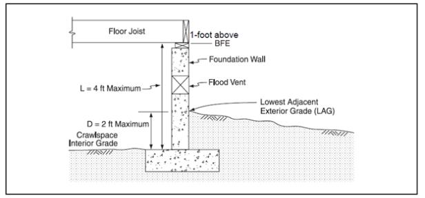
Diagram 1. Requirements regarding below-grade crawlspace construction.
(Ord. 2079 §1, 2021; Ord. 1947 §1(part), 2011).
8.24.260 Other development.
A. Fences and Walls. Fencing within the floodplain occurs frequently and can significantly increase flood elevation. This is due to the fences collecting debris and effectively creating a dam. Limited fencing will be allowed within the floodplain; provided, that it does not create flow restrictions and allows for the free flow of water. The following provisions shall apply to all fences permitted in the SFHA:
1. Fences are prohibited within the stream setback area on lots platted after the effective date of the ordinance codified in this chapter. Fences may be permitted in the stream setback area established pursuant to Section 17.60.090 on lots platted prior to the effective date of the ordinance codified in this chapter; provided, that requirements provided below are satisfied:
a. Fences in the regulatory floodway are prohibited;
b. Fences are set back a minimum of five feet from the top-of-bank;
c. Gates that are installed between properties that border a creek shall be of a width no less than twelve feet;
d. Fencing must be built in removable sections;
e. Fencing that consists of solid walls, creates a barrier impervious to stream flow or fencing that greatly restricts the flow of water is prohibited;
f. Gates installed between properties that border a creek shall have a minimum width of twelve feet;
g. Such fences, if significantly damaged or destroyed by a flood, shall require a floodplain development permit pursuant to Section 8.24.130 and subsection (A)(2) of this section to ensure that reconstruction methods are consistent with the need to minimize future flood damages.
2. Fences are a form of development and require a floodplain development permit pursuant to Section 8.24.090. Evaluation of floodplain development permit applications for proposed fences will be based on the following criteria:
a. Barbed wire fencing or other like material which creates an unreasonable or unnecessary risk of injury are prohibited.
b. Fences shall not be allowed within the special stream setback set forth in Sections 8.24.230 and 17.60.090 unless the requirements provided in subsection (A)(1) of this section are satisfied.
c. Fencing shall be limited to the types that do not greatly restrict the passage of water or cause the accumulation of debris, as provided in the table below.
3. The city may, at any time, for any reason, require removal of any fence placed in the stream setback area, with no compensation to the owner for the value of the fence. If removal is not accomplished by the owner within thirty days after city’s written request thereof, city may effect removal and disposal, and assess the property for the costs thereof in the same manner as set forth in Section 8.08.030.
4. If existing circumstances make it reasonably necessary for the city to remove a fence in the stream setback area without giving the property owner advance notice and an opportunity to remove the fence, the city may affect removal and disposal, and assess the property for the costs thereof in the same manner as set forth in Section 8.08.030, the same as if the property owner had failed to remove the fence after due notice.
5. The city shall not, under any circumstances, be responsible for any damage resulting from city’s removal of any fence placed in the stream setback area, whether such damage is to a fence, landscaping, underground sprinklers, any building or structure, loss of a pet, damage caused by a loose pet, or any other damage whatsoever, including personal injury.
|
Fence or Wall Type |
Floodway Fringe |
Regulatory Floodway |
Shallow/Sheetflow/Ponding Zones |
|---|---|---|---|
|
A |
No |
No |
No |
|
B |
Yes |
No |
Yes |
|
C |
Design review requiredi |
||
|
D |
Yes, if open at base to BFE |
No |
Yes, if open at base to BFE |
|
E |
Yes, if open at base to BFE |
No |
Yes, if open at base to BFE |
|
F |
Yes, if adequate openings at base to BFE |
No |
Yes, if adequate openings at base to BFE |
|
G |
Yes, if adequate openings at base to BFE |
No |
Yes, if adequate openings at base to BFE |
|
H |
Yes, if adequate openings at base to BFE |
No |
Yes, if adequate openings at base to BFE |
i Ensure fence will collapse under anticipated base flood conditions. Debris impacts must be considered.
|
Fence/Wall Types: |
|
|
A |
Open barb or barbless wire. “Open” means no more than one horizontal strand per foot of height |
|
B |
Open pipe or rail fencing (e.g., corrals). “Open” means rails occupy less than 10% of the fence area and posts are spaced no closer than 8 feet apart |
|
C |
Collapsible fencing |
|
D |
Other wire, pipe or rail fencing (e.g., field fence, chicken wire, etc.) which does not meet open requirements above |
|
E |
Chain link fencing |
|
F |
Continuous wood fencing |
|
G |
Masonry walls |
|
H |
Retaining walls, bulkheads |
B. Tanks.
1. New and replacement tanks in flood hazard areas shall be either elevated above the BFE on a supporting structure designed to prevent flotation, collapse or lateral movement during conditions of the base flood, or be anchored to prevent flotation, collapse or lateral movement resulting from hydrostatic loads, including the effects of buoyancy assuming the tank is empty, during conditions of the base flood. Designs for meeting the requirements above shall be certified by a registered professional engineer. The certification shall be maintained on file with the floodplain development permit as provided in Section 8.24.130(M).
2. New and replacement tank inlets, fill openings, outlets and vents shall be placed a minimum of two feet above the BFE or fitted with covers designed to prevent the inflow of floodwater or outflow of the contents of the tank during conditions of the base flood. (Ord. 1947 §1(part), 2011).
8.24.270 Interpretations and variances.
This section provides criteria and procedures for interpretations and variances to the application of provisions established in this chapter.
A. Interpretations. Requests for interpretation of the provisions of this chapter shall be made in writing to the floodplain administrator in accordance with the interpretation provisions set forth in Chapter 17.11.
1. It shall be the applicant’s responsibility to provide sufficient scientific or technical documentation to support any appeals of the floodplain administrator’s interpretation of this chapter filed in accordance with Section 17.11.200(E).
B. Variances. Exceptions to the standards and criteria of this chapter shall be made in writing to the floodplain administrator on the form provided by the city and include, at a minimum, the same information required for a floodplain development permit, a written explanation for the basis of the variance request and any necessary documentation to show the variance is warranted and meets the criteria established in subsection (B)(2) of this section.
1. Procedural Requirements. Variances shall be subject to the procedural requirements set forth in Section 17.05.400 for a Type III (quasi-judicial) review procedure.
2. Variance Criteria. The city shall approve, approve with conditions, or deny an application for a variance based on the following criteria:
a. Variances shall not be issued within a designated floodway if any increase in flood levels during the base flood discharge would result.
b. Generally, the only condition under which a variance from the elevation standard may be issued is for new construction and substantial improvements to be erected on a lot of one-half acre or less in size contiguous to and surrounded by lots with existing structures constructed below the base flood level, providing subsections (B)(2)(i)(i) though (xi) of this section have been fully considered. As the lot size increases, the technical justification required for issuing the variance increases.
c. Variances shall only be issued upon a determination that the variance is the minimum necessary, considering the flood hazard, to afford relief.
d. Variances shall only be issued upon a:
i. Showing of good and sufficient cause;
ii. Determination that failure to grant the variance would result in exceptional hardship to the applicant; and
iii. Determination that the granting of a variance will not result in increased flood heights, additional threats to public safety, extraordinary public expense, create public nuisances, cause fraud on or victimization of the public, or conflict with existing local laws or ordinances.
e. Variances may be issued for a functionally dependent use; provided, that the structure or other development is protected by methods that minimize flood damages during the base flood and create no additional threats to public safety.
f. Variances may be issued for the reconstruction, rehabilitation, or restoration of structures listed on the National Register of Historic Places or the Statewide Inventory of Historic Properties, without regard to the procedures set forth in this section.
g. Variances as interpreted in the National Flood Insurance Program are based on the general zoning law principle that they pertain to a physical piece of property; they are not personal in nature and do not pertain to the structure, or its inhabitants’ economic or financial circumstances. They primarily address small lots in densely populated residential neighborhoods. As such, variances from the flood elevations should be quite rare.
h. Variances may be issued for nonresidential buildings in very limited circumstances to allow a lesser degree of floodproofing than watertight or dry-floodproofing, where it can be determined that such action will have low damage potential, complies with all other variance criteria and otherwise complies with the building codes.
i. In passing upon such applications, the city shall consider all technical evaluations, all relevant factors, standards specified in other sections of this chapter and the:
i. Danger that materials may be swept onto other lands to the injury of others;
ii. Danger to life and property due to flooding or erosion damage;
iii. Susceptibility of the proposed facility and its contents to flood damage on the individual owner;
iv. Importance of the services provided by the proposed facility to the community;
v. Necessity to the facility of a waterfront location, where applicable;
vi. Availability of alternative locations for the proposed use, which are not subject to flooding or erosion damage;
vii. Compatibility of the proposed use with existing and anticipated development;
viii. The relationship of the proposed use to the comprehensive plan and floodplain management program for that area;
ix. Safety of access to the property in times of flood for ordinary and emergency vehicles;
x. Expected heights, velocity, duration, rate of rise, and sediment transport of the floodwaters and the effects of wave action, if applicable, expected at the site; and
xi. Costs of providing governmental services during and after flood conditions, including maintenance and repair of public utilities and facilities such as sewer, gas, electrical, and water systems, as well as streets and bridges.
3. Variance Notification. Any applicant to whom a variance is granted shall be given written notice that the issuance of a variance to construct a structure below the base flood elevation will result in increased premium rates for flood insurance and that such construction below the base flood elevation increases risks to life and property. Such notification and a record of all variance actions, including justification, shall be maintained in accordance with Section 17.05.400. (Ord. 2079 §1, 2021; Ord. 1947 §1(part), 2011).
8.24.280 Penalties for noncompliance.
No structure or land shall hereafter be constructed, located, extended, converted, or altered without full compliance with the terms of this chapter and other applicable regulations. Violations of the provisions of this chapter by failure to comply with any of its requirements (including violations of conditions and safeguards established in connection with conditions) shall constitute a misdemeanor. Each and every day during any portion of which any violation of this chapter is committed, continued or permitted by any person constitutes a separate violation. Any person who violates this chapter or fails to comply with any of its requirements shall upon conviction thereof be fined not more than two hundred fifty dollars per day or imprisoned for not more than five days, or both, for each violation and in addition shall pay all costs and expenses involved in the case. Each day that passes constitutes a separate offense. Nothing contained in this chapter shall prevent the city from taking such other lawful action as is necessary to prevent or remedy any violation. (Ord. 1947 §1(part), 2011).
8.24.290 Severability.
The chapter is hereby declared to be severable. Should any portion of this chapter be declared invalid by a court of competent jurisdiction, the remaining provisions shall continue in full force and effect and shall be read to carry out the purpose(s) of the chapter before the declaration of partial invalidity. (Ord. 1947 §1(part), 2011).
8.24.300 Abrogation and greater restrictions.
This chapter is not intended to repeal, abrogate, or impair any existing easements, covenants or deed restrictions. However, where this chapter and another ordinance, state building code, easement, covenant or deed restriction conflict or overlap, whichever imposes the more stringent restrictions shall prevail. (Ord. 1947 §1(part), 2011).
Prior ordinance history: Ords. 1585, 1716, 1749, 1767, 1768 and 1785.