


Chapter 18.85
PUBLIC FACILITIES
Sections:
18.85.010 Purpose and applicability.
18.85.020 Transportation standards.
18.85.040 Sanitary sewer and water service improvements.
18.85.050 Storm drainage and surface water management facilities.
18.85.080 Construction plan approval.
18.85.090 Facility installation.
18.85.100 Performance guarantee and warranty.
18.85.010 Purpose and applicability.
1. Purpose. The standards of this chapter implement the public facility policies of the City of Harrisburg comprehensive plan and the City’s adopted public facility master plans.
2. Applicability. This chapter applies to developments subject to land division (subdivision or partition) approval and developments subject to site design review where public facility improvements are required. All public facility improvements within the City shall occur in accordance with the standards and procedures of this chapter.
3. Public Works/Engineering Design Standards. All public facility improvements, including, but not limited to, sanitary sewer, water, transportation, surface water and storm drainage, and parks projects, whether required as a condition of development or provided voluntarily, shall conform to the City of Harrisburg “design manual.” Where a conflict occurs between this code and the manual, the provisions of the design manual shall govern.
4. Public Improvement Requirement. No building permit may be issued until all required public facility improvements are in place and approved by the Public Works Director and/or City Engineer, or otherwise bonded. The City may allow deferral of required public improvements and require the applicant to record certification of nonremonstrance in conformance with the provisions of this code and the design manual.
5. Improvements required as a condition of development approval, when not voluntarily provided by the applicant, shall be roughly proportional to the impact of the development on public facilities. Findings in the development approval shall indicate how the required improvements directly relate to and are roughly proportional to the impact of development. [Ord. 987 § 1 (Exh. A), 2022.]
18.85.020 Transportation standards.
1. General Requirements.
a. Except as provided by subsection (1)(e) of this section, existing substandard streets and planned streets within or abutting a proposed development shall be improved in accordance with the standards of this chapter as a condition of development approval.
b. All street improvements, including the extension or widening of existing streets and public access ways, shall conform to this section, and shall be constructed consistent with the City of Harrisburg Engineering Design Standards Manual.
c. All new publicly owned streets shall be contained within a public right-of-way. Public pedestrian access ways may be contained within a right-of-way or a public access easement, as required by the City Engineer.
d. The purpose of this subsection is to coordinate the review of land use applications with roadway authorities and to implement Section 660-012-0045(2)(e) of the State Transportation Planning Rule, which requires the City to adopt a process to apply conditions to development proposals in order to minimize impacts and protect transportation facilities.
(1) When a Traffic Impact Analysis Is Required. The City or other road authority with jurisdiction may require a traffic impact analysis (TIA) as part of an application for development, a change in use, or a change in access. A TIA may be required by the City Administrator where a change of use or a development would involve one or more of the following:
(a) A change in zoning or a plan amendment designation, as may be required to determine compliance with OAR 660-012-0060, Transportation Planning Rule;
(b) Operational or safety concerns documented in writing by a road authority;
(c) An increase in site traffic volume generation by 300 average daily trips (ADT) or more;
(d) An increase in peak hour volume of a particular movement to and from a street or highway by 20 percent or more;
(e) An increase in the use of adjacent streets by vehicles exceeding the 20,000-pound gross vehicle weights by 10 vehicles or more per day;
(f) Existing or proposed approaches or access connections that do not meet minimum spacing or sight distance requirements or are located where vehicles entering or leaving the property are restricted, or such vehicles are likely to queue or hesitate at an approach or access connection, creating a safety hazard;
(g) A change in internal traffic patterns that may cause safety concerns; or
(h) A TIA required by ODOT pursuant to OAR 734-051.
(2) Traffic Impact Analysis Preparation. A professional engineer registered by the State of Oregon, in accordance with the requirements of the road authority, shall prepare the traffic impact analysis.
e. The City Engineer or authorized representative may waive or allow deferral of standard street improvements, including sidewalk, roadway, bicycle lane, undergrounding of utilities, and landscaping, as applicable, where one or more of the following conditions in subsections (1)(e)(1) through (4) of this section is met. Where the City Engineer or authorized representative agrees to defer a street improvement, it shall do so only where the property owner agrees not to remonstrate against the formation of a local improvement district in the future.
(1) The standard improvement conflicts with an adopted capital improvement plan.
(2) The standard improvement would create a safety hazard.
(3) It is unlikely due to the developed condition of adjacent property that the subject improvement would be extended in the foreseeable future, and the improvement under consideration does not by itself significantly improve transportation operations or safety.
(4) The improvement under consideration is part of an approved minor partition in the R-1 or R-2 zone and the proposed partition does not create any new street.
(5) The City Administrator may accept development of a privately owned street in lieu of a standard public street improvement where the private street is designed to serve pedestrian, bicycle, and local automobile traffic and is not contrary to the City’s transportation systems plan or other development code standard.
2. Street Location, Alignment, Extension, and Grades.
a. All new streets, to the extent practicable, shall connect to the existing street network and allow for the continuation of an interconnected street network, consistent with adopted public facility plans and pursuant to subsection (4) of this section, Transportation Connectivity and Future Street Plans.
b. Specific street locations and alignments shall be determined in relation to existing and planned streets, topographic conditions, public convenience and safety, and in appropriate relation to the proposed use of the land to be served by such streets.
c. Grades of streets shall conform as closely as practicable to the original (predevelopment) topography to minimize grading.
d. New streets and street extensions exceeding a grade of 15 percent over a distance more than 200 feet, to the extent practicable, shall be avoided. Where such grades are unavoidable, the Planning Commission may approve an exception to the 200-foot standard and require mitigation, such as a secondary access for the subdivision, installation of fire protection sprinkler systems in dwellings, or other mitigation to protect public health and safety.
e. Where the locations of planned streets are shown on a local street network plan, the development shall implement the street(s) as shown on the plan.
f. Where required local street connections are not shown on an adopted City street plan, or the adopted street plan does not designate future streets with sufficient specificity, the development shall provide for the reasonable continuation and connection of existing streets to adjacent developable properties, conforming to the standards of this code and approval of the Public Works Director and/or City Engineer.
g. Existing street-ends that abut a proposed development site shall be extended within the development, unless prevented by environmental or topographical constraints, existing development patterns, or compliance with other standards in this code. In such situations, the applicant must provide evidence that the environmental or topographic constraint precludes reasonable street connection.
h. Proposed streets and any street extensions required pursuant to this section shall be located, designed, and constructed to allow continuity in street alignments and to facilitate future development of vacant or redevelopable lands.
3. Rights-of-Way and Street Section Widths. The standards contained in Table 18.85.020.3 are intended to provide for streets of suitable location, width, and design to accommodate expected vehicle, pedestrian, and bicycle traffic; to afford satisfactory access to law enforcement, fire protection, sanitation, and road maintenance equipment; and to provide a convenient and accessible network of streets, avoiding undue hardships to adjoining properties. Where a range of street width or improvement options is indicated, the City Administrator or Planning Commission shall determine requirements based on the advice of a qualified professional and all of the following factors:
a. Street classification and requirements of the roadway authority, if different than the City’s street classifications and requirements;
b. Existing and projected street operations relative to applicable standards;
c. Safety of motorists, pedestrians, bicyclists, and transit users, including consideration of accident history;
d. Convenience and comfort for pedestrians, bicyclists, and transit users;
e. Provision of on-street parking;
f. Placement of utilities;
g. Street lighting;
h. Slope stability, erosion control, and minimizing cuts and fills;
i. Surface water management and storm drainage requirements;
j. Emergency vehicles or apparatus and emergency access, including evacuation needs;
k. Transitions between varying street widths (i.e., existing streets and new streets); and
l. Other factors related to public health, safety, and welfare.
|
Table 18.85.020.3 |
||||||||||||
|---|---|---|---|---|---|---|---|---|---|---|---|---|
|
Width of each of the following (in feet) |
Alleys |
Neighborhood/Local |
Collector |
Arterial |
Transit/Rail Corridor |
Recreational Street |
||||||
|
|
R/W |
Street |
R/W |
Street |
R/W |
Street |
R/W |
Street |
R/W |
Street |
R/W |
Street |
|
Extra R/W |
2 |
– |
1 |
– |
1 |
– |
1 |
– |
1 |
– |
1 |
– |
|
Planter or utility |
– |
– |
5 |
– |
6 |
– |
6 |
– |
– |
– |
6 |
– |
|
Sidewalk |
– |
– |
5 |
– |
6 |
– |
6 |
– |
5 |
5 |
6 |
– |
|
Bike lane |
– |
– |
– |
– |
6 |
6 |
6 |
6 |
– |
– |
6 |
6 |
|
Parking lane |
– |
– |
8 |
8 |
8 |
8 |
8 |
8 |
8 |
8 |
8 |
8 |
|
Travel or turn lane |
– |
12 |
10 |
10 |
11 |
11 |
12 |
12 |
14 |
14 |
– |
11 |
|
Railroad corridor |
– |
– |
– |
– |
– |
– |
– |
– |
14-20 |
14-20 |
– |
– |
|
Minimum street width |
12 |
29 |
36 |
48 |
48 |
36 |
||||||
|
Right-of-way |
14 |
45-50 |
60 |
60-72 |
60-72 |
60 |
||||||
* All streets shall be improved in accordance with the construction standards and specifications of the applicable roadway authority, including requirements for pavement, curbs, drainage, striping, and traffic control devices. Where a parking strip is provided it shall consist of a planter/utility strip between the sidewalk and the curb or roadway. Where a swale is provided, it shall either be placed between the roadway and sidewalk or behind the sidewalk on private property, subject to City approval and recording of required public drainage way and drainage way maintenance easements. Streets with parking on one side only should be avoided. When used, they must be posted NO PARKING.
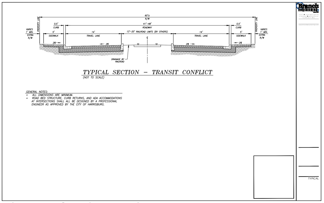
The schematic below is representative of a typical street section in relation to a transit conflict.
4. Transportation Connectivity and Future Street Plans. The following standards apply to the creation of new streets:
a. Intersections. Streets shall be located and designed to intersect as nearly as possible to a right angle. Street intersections shall have a minimum intersection angle of 75 degrees. All legs of an intersection shall meet the above standard for at least 100 feet back from the point of intersection. No more than two streets shall intersect, i.e., creating a four-legged intersection, at any one point. Street jogs and intersection offsets of less than 125 feet are not permitted. Intersections shall be designed to facilitate storm water runoff into City-approved storm water facilities.
b. Access Ways. The Planning Commission, in approving a land use application with conditions, may require a developer to provide an access way where the creation of a cul-de-sac or dead-end street is unavoidable, and the access way connects the end of the street to another street, a park, or a public access way. Access ways shall be contained within a public right-of-way or public access easement, as required by the City.
c. Connectivity to Abutting Lands. The street system of a proposed subdivision shall be designed to connect to existing, proposed, and planned streets adjacent to the subdivision. Wherever a proposed development abuts unplatted land or a future development phase of an existing development, street stubs shall be provided to allow access to future abutting subdivisions and to logically extend the street system into the surrounding area. Street ends shall contain turnarounds constructed to Uniform Fire Code standards, as the City deems applicable, and shall be designed to facilitate future extension in terms of grading, width, and temporary barricades.
d. Street Connectivity and Formation of Blocks. In order to promote efficient vehicular and pedestrian circulation throughout the City, subdivisions and site developments shall be served by an interconnected street network, pursuant to the standards in subsections (4)(d)(1) through (4) of this section. Distances are measured from the edge of street rights-of-way. Where a street connection cannot be made due to physical site constraints, approach spacing requirements, access management requirements, or similar restrictions, where practicable, a pedestrian access way connection shall be provided pursuant to Chapter 18.70 HMC.
(1) Residential zones: minimum of 200-foot block length and maximum of 750-foot length; maximum 2,000-foot block perimeter;
(2) Downtown/Main Street zone: minimum of 200-foot length and maximum of 400-foot length; maximum 1,200-foot perimeter;
(3) General commercial zone and light industrial zone: minimum of 100-foot length and maximum of 1,000-foot length; maximum 2,600-foot perimeter; and
(4) Not applicable to general industrial zone.
e. A Cul-De-Sac Street. Where the City determines that a cul-de-sac is allowed, all of the following standards shall be met:
(1) The cul-de-sac shall not exceed a length of 400 feet, except where the Planning Commission through a Type III procedure determines that topographic or other physical constraints of the site require a longer cul-de-sac. The length of the cul-de-sac shall be measured along the centerline of the roadway from the near side of the intersecting street to the farthest point of the cul-de-sac.
(2) The cul-de-sac shall terminate with a circular or hammerhead turnaround meeting the Uniform Fire Code and the standards of Table 18.85.020.3.
(3) The cul-de-sac shall provide, or not preclude the opportunity to later install, a pedestrian and bicycle access way between it and adjacent developable lands. Such access ways shall conform as specified in this chapter.
5. Engineering Design Standards. Street design shall conform to the standards of the applicable roadway authority; for City streets that is the Engineering/Public Works Design Standards Manual. Where a conflict occurs between this code and the manual, the provisions of the Engineering/Public Works Design Manual shall govern.
6. Fire Code Standards. Where fire code standards conflict with City standards, the City shall consult with the Fire Marshal in determining appropriate requirements. The City shall have the final determination regarding applicable standards.
7. Substandard Existing Right-of-Way. Where an existing right-of-way adjacent to a proposed development is less than the standard width, the Planning Commission may require the dedication of additional rights-of-way at the time of subdivision, partition, or site plan review, to mitigate the impacts of development pursuant to the standards in Table 18.85.020.3.
8. Traffic Calming. The City may require the installation of traffic calming features to mitigate the impacts of development and slow traffic in neighborhoods or commercial areas with high pedestrian traffic.
9. Sidewalks, Planter Strips, and Bicycle Lanes. Except where the City Administrator grants a deferral of public improvements, pursuant to Chapter 19.15 or 19.20 HMC, sidewalks, planter strips, and bicycle lanes shall be installed concurrent with development or widening of new streets, pursuant to the requirements of this chapter. Maintenance of sidewalks and planter strips in the right-of-way is the continuing obligation of the adjacent property owner.
10. Streets Adjacent to Railroad Right-of-Way. When a transportation improvement is proposed within 300 feet of a railroad crossing, or a modification is proposed to an existing railroad crossing, the Oregon Department of Transportation and the rail service provider shall be notified and City design standards required.
11. Street Names. No new street name shall be used which will duplicate or be confused with the names of existing streets in the City of Harrisburg or vicinity.
12. Survey Monuments. Upon completion of a street improvement and prior to acceptance by the City, it shall be the responsibility of the developer’s registered professional land surveyor to provide certification to the City that all boundary and interior monuments have been reestablished and protected.
13. Street Signs. The City shall install all signs for traffic control and street names, which shall conform to existing City design standards and the MUTCD. The cost of signs required for new development shall be the responsibility of the developer. Street name signs shall be installed at all street intersections. Stop signs and other signs may be required. All required signs must be installed and paid for prior to the issuance of a CO.
14. Streetlight Standards. Streetlights shall be relocated or new lights installed, as applicable, with street improvement projects. Streetlights shall conform to City standards, or the requirements of the roadway authority, if different than the City.
15. Mailboxes. Mailboxes shall conform to the requirements of the United States Postal Service and the State of Oregon Structural Specialty Code.
16. Street Cross-Sections. The final lift of pavement shall be placed on all new constructed public roadways prior to final City acceptance of the roadway unless otherwise approved by the Planning Commission. [Ord. 987 § 1 (Exh. A), 2022.]
18.85.030 Public use areas.
1. Dedication of Public Use Areas.
a. Where a proposed park, playground, or other public use shown in a plan adopted by the City is located in whole or in part in a subdivision or the PUZ zone, the City may require the dedication or reservation of this area on the final plat for the subdivision or major plat to mitigate development impacts, provided the open space dedication or reservation is roughly proportionate to the impacts of development on the City park system.
b. The City may purchase or accept voluntary dedication or reservation of areas, either within or near the proposed subdivision, that are suitable for the development of parks and other public uses; however, the City is under no obligation to accept such areas offered for dedication or sale. [Ord. 987 § 1 (Exh. A), 2022.]
18.85.040 Sanitary sewer and water service improvements.
1. Sewers and Water Mains Required. All new development requiring land use approval is required to connect to City water and sanitary sewer systems. Sanitary sewer and water system improvements shall be installed to serve each new development and to connect developments to existing mains in accordance with the adopted facility master plans and applicable engineering/public works design standards. Where streets are required to be stubbed to the edge of the subdivision, sewer and water system improvements and other utilities shall also be stubbed with the streets, except as approved by the City Engineer where alternate alignment(s) are provided consistent with the adopted public facility master plan.
2. Sewer and Water Plan Approval. Development permits for sewer and water improvements shall not be issued until the Public Works Director and/or City Engineer has approved all sanitary sewer and water plans in conformance with City standards and State regulatory authority, if needed.
3. Over-Sizing. The City may require as a condition of development approval that sewer and water lines serving new development be sized to accommodate future development within the area as projected by the applicable facility master plans. In these instances, the City may authorize cost-recovery or cost-sharing methods as provided under State law.
4. Inadequate Facilities. Development permits may be restricted or rationed by the Planning Commission where a deficiency exists in the existing water or sewer system that cannot be rectified by the development and which, if not rectified, will result in a threat to public health or safety, surcharging of existing mains, or violations of State or Federal standards pertaining to operation of domestic water and sewerage treatment systems. The City Administrator may require water booster pumps, sanitary sewer lift stations, and other critical facilities be installed with backup power. [Ord. 987 § 1 (Exh. A), 2022.]
18.85.050 Storm drainage and surface water management facilities.
1. General Provisions. The City shall issue a development permit only where adequate provisions for storm water runoff have been made in conformance with a 25-year storm plan. All applications for developments that increase impervious surface must submit a specific storm water plan with their application unless waived by the City Engineer.
2. Accommodation of Upstream Drainage. Culverts and other drainage facilities shall be large enough to accommodate existing and potential future runoff from the entire upstream drainage area, whether inside or outside the development. Such facilities shall be subject to review and approval by the City Engineer.
3. Effect on Downstream Drainage. Where it is anticipated by the City Engineer that the additional runoff resulting from the development will overload an existing drainage facility, the City shall withhold approval of the development until provisions have been made for improvement of the potential condition or until provisions have been made for retention of additional runoff caused by the development in accordance with City standards.
4. Over-Sizing. The City may require as a condition of development approval that sewer, water, or storm drainage systems serving new development be sized to accommodate future development within the area as projected by the applicable facility master plan. In these instances, the City may authorize cost-recovery or cost-sharing methods as provided under State law.
5. Existing Watercourse. Where a proposed development is traversed by a watercourse, drainage way, swale, channel, or stream, there shall be provided a storm water easement or drainage right-of-way conforming substantially with the lines of such watercourse and such further width as will be adequate for conveyance and maintenance to protect the public health and safety. All applications for site plan review, subdivision, and partitions must submit a specific storm water plan with their application unless waived by the City Engineer. [Ord. 987 § 1 (Exh. A), 2022.]
18.85.060 Utilities.
The following standards apply to new development where extension of electric power, natural gas or communication lines is required:
1. General Provision. The developer of a property is responsible for coordinating the development plan with the applicable utility providers and paying for the extension and installation of utilities not otherwise available to the subject property.
2. Underground Utilities.
a. General Requirement. The requirements of the utility service provider shall be met. All utility lines in new subdivisions, including, but not limited to, those required for electric, communication, lighting, and related facilities, shall be placed underground, except where the City Administrator or Planning Commission determines that placing utilities underground would adversely impact adjacent land uses. The City Administrator or Planning Commission may require screening and buffering of aboveground facilities to protect the public health, safety, or welfare.
b. Subdivisions and Partitions. In order to facilitate underground placement of utilities, the following additional standards apply to all new subdivisions:
(1) The developer shall make all necessary arrangements with the serving utility to provide the underground services. Care shall be taken to ensure that no aboveground equipment obstructs vision clearance areas for vehicular traffic, per Chapter 18.70 HMC, Access and Circulation.
(2) The City Engineer reserves the right to approve the location of all surface-mounted facilities.
(3) All underground utilities installed in streets must be constructed and approved by the applicable utility provider prior to the surfacing of the streets.
(4) Stubs for service connections shall be long enough to avoid disturbing the street improvements when service connections are made.
3. Exception to Undergrounding Requirement. The City or Planning Commission may grant exceptions to the undergrounding standard where existing physical constraints, such as geologic conditions, streams, or existing development conditions make underground placement impractical. [Ord. 987 § 1 (Exh. A), 2022.]
18.85.070 Easements.
1. Provision. The developer shall coordinate with the City and applicable utility providers in meeting the needs of each utility franchise for the provision and dedication of utility easements necessary to provide full services to the development.
2. Standards. Utility easements shall conform to the requirements of the utility service provider. All other easements shall conform to the City of Harrisburg engineering design standards/public works design standards.
3. Recordation. All easements for sewers, storm drainage and water quality facilities, water mains, electric lines, natural gas lines, or other utilities shall be recorded and referenced on a survey or final plat, as applicable. See Chapter 19.15 HMC, Site Design Review, and Chapter 19.20 HMC, Land Divisions and Property Line Adjustments. [Ord. 987 § 1 (Exh. A), 2022.]
18.85.080 Construction plan approval.
No development, including sanitary sewers, water, streets, utilities, parking areas, buildings, or other development, shall be undertaken without plans having been approved by the City of Harrisburg, permit fees paid, and permits issued. Permit fees are required to defray the cost and expenses incurred by the City for construction and other services in connection with the improvement. Permit fees are as set by City Council resolution. [Ord. 987 § 1 (Exh. A), 2022.]
18.85.090 Facility installation.
1. Conformance Required. Improvements installed by the developer, either as a requirement of these regulations or at the developer’s option, shall conform to the requirements of this chapter, approved construction plans, and to improvement standards and specifications adopted by the City.
2. Adopted Installation Standards. The City of Harrisburg has adopted various engineering/public works design standards for public improvements and private utility installation within the public right-of-way. All adapted engineering/public works design standards shall be met unless one or more partial waivers are granted by the City Engineer and City Administrator.
3. Commencement. Work in a public right-of-way shall not begin until all applicable agency permits have been approved and issued.
4. Resumption. If work is discontinued for more than six months, it shall not be resumed until the Public Works Director and/or City Engineer grants written approval for the recommencement of work or a hiatus of more than six months.
5. City Inspection. Improvements shall be constructed under the inspection of the City Engineer or Public Works Director. The City Engineer or Public Works Director may approve minor changes in typical sections and details if unusual conditions arising during construction warrant such changes in the public interest, except those substantive changes to the approved design shall be subject to review under Chapter 19.30 HMC, Modifications to Approved Plans and Conditions of Approval. (Any survey monuments that are disturbed before all improvements are completed by the developer or subdivider shall be replaced prior to final acceptance of the improvements.) Any new or disturbed monuments must be replaced by a certified land surveyor.
6. Engineer’s Certification and As-Built Plans. A registered civil engineer shall provide written certification in a form required by the City that all improvements, workmanship, and materials are in accordance with current and standard engineering and construction practices, conform to approved plans and conditions of approval, and are of high grade, prior to City’s acceptance of the public improvements, or any portion thereof, for operation and maintenance. The developer’s engineer shall also provide two sets of “as-built” plans for permanent filing with the City. If required by the City, the developer or subdivider shall provide a warranty bond pursuant to HMC 18.85.100. [Ord. 987 § 1 (Exh. A), 2022.]
18.85.100 Performance guarantee and warranty.
1. Performance Guarantee Required. The City at its discretion may approve a final plat or building permit when it determines that at least 50 percent of the public improvements required for the site development or land division, or phase thereof, are complete and the applicant has posted an acceptable assurance of performance bond for the balance of said improvements.
2. Determination of Sum. The assurance of performance bond shall be for a sum determined by the City Engineer as required to cover the cost of the improvements and repairs, including related engineering and incidental expenses, plus reasonable inflationary costs. The assurance bond shall not be less than 110 percent of the estimated improvement costs.
3. Itemized Improvement Estimate. The applicant shall furnish to the City an itemized improvement estimate, certified by a registered civil engineer, to assist the City in calculating the amount of the performance assurance.
4. Development Agreement. A written agreement between the City and applicant shall be signed and recorded. The agreement may include a provision for the construction of the improvements in stages and for the extension of time under specific conditions. The agreement shall contain all of the following:
a. The period within which all required improvements and repairs shall be completed;
b. A provision that if work is not completed within the period specified, the City may complete the work and recover the full cost and expenses from the applicant directly or an applicant-provided bond.
c. The required improvement fees and deposits.
5. When Applicant Fails to Perform. In the event the applicant fails to carry out all provisions of the agreement and the City has unreimbursed costs or expenses resulting from such failure, the City shall call on the bond, cash deposit, or letter of credit for reimbursement or take other appropriate action to recover all unreimbursed costs.
6. Termination of Performance Guarantee. The applicant shall not cause termination, nor allow expiration, of the guarantee/bond without first securing written authorization from the City.
7. Warranty Bond. A warranty bond good for two years is required on all public improvements and landscaping when installed in the public right-of-way. The warranty bond shall equal 15 percent of the total cost of improvements and begin upon acceptance of said improvements by the City. [Ord. 987 § 1 (Exh. A), 2022.]