


Chapter 19.55
DEFINITIONS
Sections:
19.55.010 Purpose.
The purpose of this chapter is to define terms that are used in the City of Harrisburg development code and other terms that may arise in interpreting the code, particularly those that may be uncommon or have more than one meaning. [Ord. 987 § 1 (Exh. A), 2022.]
19.55.020 Applicability.
1. Definitions. The definitions in this chapter apply to all actions and interpretations under the City of Harrisburg development code. The meanings of some terms in this chapter may, in certain contexts in which they are used, be clearly inapplicable. In such cases the context in which a term is used will indicate its intended meaning, and that intent shall control.
2. When a Term Is Not Defined. Terms not defined in this chapter shall have their ordinary accepted meanings within the context in which they are used. Webster’s Third New International Dictionary of the English Language, Unabridged, shall be considered a standard reference.
3. Land Use Categories. This chapter defines the land use categories used in HMC Title 18, Division 2.
4. Conflicting Definitions. Where a term listed in this chapter is defined by another section of this code or by other regulations or statutes referenced by this code, the term is not redefined herein for purposes of that other code. [Ord. 987 § 1 (Exh. A), 2022.]
19.55.030 Definitions.
The following definitions are organized alphabetically.
“Abutting” means contiguous or adjoining.
“Access” means a way or means of approach to provide pedestrian, bicycle, and/or motor vehicular entrances or exits to a property.
“Access control” means where the right of access between a property abutting the highway and the highway has been acquired by a roadway authority, or eliminated by law, pursuant to access or approach spacing standards.
“Access easement” means an easement conveyed for the purpose of providing vehicle, bicycle, and/or pedestrian access from a public street to a lot or parcel across intervening property under separate ownership from the parcel being provided access. Cross access easement is an easement providing vehicular access between two or more separate sites, so that the driver need not enter the public street system between sites.
“Access management” means the systematic control of the location, spacing, design, and operation of driveways, median openings, interchanges, and street connections to a roadway to minimize conflicts between turning and through vehicles, bicyclists, and pedestrians. The purpose of access management is to provide vehicular access to land development in a manner that preserves the safety and efficiency of the transportation system. Public facility measures to support access management include roadway design applications, such as median treatments and auxiliary lanes, and the appropriate spacing of traffic signals. Measures that may be included as conditions of approval for development decisions include, but are not limited to: (a) standards such as minimum spacing of driveways and on-site vehicle storage requirements; (b) mitigations related to site conditions such as right-in-right-out only approaches, medians, dedicated turn lanes, and shared driveways; and (c) provision for future opportunities for mitigation by land dedication or easement.
“Access management plan” means a plan adopted by the City, or jointly by the Oregon Transportation Commission (OTC) in coordination with the City, for managing access on a designated section of an arterial street or highway, or within the influence area of a highway interchange.
“Access point” means a connection providing for the movement of vehicles between a lot or parcel and a public roadway.
“Access, reasonable” means access that does not require excessive out-of-direction travel or pose a safety hazard.
“Access spacing” or “intersection spacing” means the minimum required distance from an intersection of a public or private street to the nearest driveway or other access connection, measured from the closest edge of the pavement of the intersecting street to the closest edge of the pavement of the connection along the traveled way.
“Access way” means a walkway providing a through connection for pedestrians between two streets, between two lots, or between a development and a public right-of-way. It may be an access way for pedestrians and bicyclists (with no vehicle access), or a walkway on public or private property (i.e., with a public access easement); it may also be designed to accommodate emergency vehicles. See also “Walkway.”
Accessible. Two meanings are possible depending on the specific code provision. In general, “accessible” means approachable by pedestrians, vehicles, or other transportation modes, as applicable. “Accessible” may also mean approachable and usable by people with disabilities, in conformance with the Federal Americans with Disabilities Act. Either or both definitions may apply in a particular situation.
“Accessory dwelling” means an accessory structure to a single-family dwelling used as a separate residence on the same parcel of land as the single-family dwelling it is accessory to.
“Accessory structure” means a structure of secondary importance or function on a site. In general, the primary use of the site is not carried on in an accessory structure. Accessory structures are detached from the primary structure. Examples of accessory structures include, but are not limited to, garages, decks, fences, arbors, gazebos, heat pumps, workshops, and other structures. See also “Primary structure.”
“Accessory use” means a use or activity that is a subordinate part of a primary use and that is clearly incidental to a primary use on a site. See also “Primary use.”
“Adjacent” means abutting or located directly across a street right-of-way or easement.
“Affordable housing” means any type of residential development where at least 40 percent of the proposed dwelling units are or will be available for rent or sale to the general public at amounts not to exceed 40 percent of the most recent Linn County definition (standards) for low to moderate household income.
“Alter” or “alteration” means a change in use or occupancy or physical change to a structure or site. Alteration does not include normal maintenance and repair. Alterations may or may not require land use approval, but property owners should check with the City of Harrisburg before preparing project plans or commencing development. Alterations include, but are not limited to, the following:
a. Changes in use or occupancy;
b. Changes to the exterior of a building;
c. Changes to the interior of a building;
d. Increases or decreases in floor area of a building;
e. Changes to other structures on the site, or the development of new structures;
f. Changes to exterior improvements;
g. Changes to landscaping; and
h. Changes in the topography of the site.
“Alternate access” means the right to access a property by means other than the proposed approach or access connection. It may include an existing public right-of-way, another location on the subject street or highway, an easement across adjoining property, a different street, a service road, a local road, or an alley, and may be in the form of a single or joint approach.
“Applicant” means a person who applies for a permit or approval under this code. An applicant can be the owner of the property, a contract purchaser, or someone who is legally authorized to represent the owner, such as a builder, developer, or contract purchaser.
“Bed and breakfast inn” means any establishment located in a structure designed for a single-family residence and structures appurtenant thereto, providing limited overnight lodging and meals for guests pursuant to the special use requirements for bed and breakfast inns.
“Block” means all of the property bounded by streets, rights-of-way (pedestrian or vehicle ways), water features, or any combination thereof, but is not divided or separated in any way by streets or water features.
“Block face” or “street frontage” means all of the property fronting on one side of a street that is between intersecting or intercepting streets, or that is between a street and a water feature, or end of a dead-end street. An intercepting street determines the boundary of the block frontage only on the side of the street that it intercepts. See figure below.
Block Frontage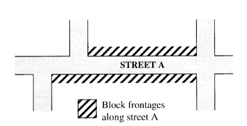
Building. See applicable building code.
“Building footprint” means the outline of a building, as measured around its foundation.
“Building Inspector” means the person certified by the State of Oregon to perform various types of building, electrical, plumbing, and mechanical inspections.
“Building line” means a line running parallel to a lot line that is the same distance from the lot line as the closest portion of a building on the site, typically used in reference to required setback yards. See figure below.
Building Lines
“Building Official” means the person certified by the State of Oregon who enforces the building ordinances and regulations for the City, and other ordinances and regulations as assigned.
“Building/structure height” means the vertical distance from the grade plane to the average height of the highest roof structure.
“Bulb-out” means a concrete traffic structure intended to make pedestrian street crossings safer and to reduce traffic speeds. They involve extending the curb and walkway a few feet into the street area and are located at intersections or in the middle of long blocks.
“Capacity” means maximum holding or service ability, as used for transportation, utilities, parks, and other public facilities. See also, definition of “occupancy” in applicable building codes.
“Carport” means a stationary structure consisting of a roof, its supports, and not more than one wall or storage cabinet substituting for a wall, used to shelter motor vehicles, recreational vehicles, or boats; does not include temporary shelters or canopies not affixed to a permanent foundation per applicable building codes.
“Change of use” means change in the primary or basic type of use(s) on a site.
“Child care facility” means a facility that provides care and supervision of minor children for periods of less than 24 hours that does not otherwise meet the definition of family daycare.
“City” means the City of Harrisburg, Oregon.
“City Planner” means the person designated by the City of Harrisburg to deal with land use matters on behalf of the City, or that person’s designee.
“Clear and objective” means decision criteria and standards that do not involve substantial discretion or individual judgment in their application.
“Clearing” (as in clearing and grading) means any activity that removes existing vegetation or strips surface material from any portion of the site and exceeding typical yard maintenance for a single-family dwelling.
“Club” means any organization, group, or association supported by the members thereof, the purpose of which is to render a service customarily rendered for members and their guests, but shall not include any organization, group, or association, the chief activity of which is to render a service customarily carried on as a business.
“Commercial” means land use involving buying/selling of goods or services as the primary activity. See also “Retail sales and service uses.”
“Commercial outdoor recreation” (land use) includes firing ranges, golf courses, and driving ranges, etc.
“Commission” means the Planning Commission of the City of Harrisburg, Oregon.
“Common area” means land jointly owned to include open space, landscaping, or recreation facilities (e. g., may be managed by a homeowners’ association).
“Community or public interest(s)” means those activities or development proposals that provide a tangible benefit(s) to the quality of life of City residents, including greater safety, educational opportunities, recreation, professional or commercial services, employment, transportation, or other public services.
Community Services (Land Use). Community services are uses of a public, nonprofit, or charitable nature generally providing a local service to people of the community, except for schools, which are categorized separately. Generally, they provide the service on the site or have employees at the site on a regular basis. The service is ongoing, not just for special events. Private lodges, clubs, and nonprofit organizations that have membership provisions may be considered a community service. Uses providing mass shelter or short-term housing where tenancy may be arranged for periods of less than one month, when operated by a public or nonprofit agency, may also be considered a community service. The use may also provide special counseling, education, or training of a public, nonprofit, or charitable nature. See also “Religious institutions and places of worship” and “Parks and open space.”
“Comprehensive plan” means the current adopted comprehensive plan of the City of Harrisburg.
“Comprehensive plan amendment” means an amendment to the text or map of the current comprehensive plan which has been adopted.
“Conditional use” means a use that requires a conditional use permit. See Chapter 19.25 HMC.
“Condominium” means ownership of a single unit in a multi-unit structure that may contain common areas and facilities; includes both residential and commercial condominiums. See ORS Chapter 100 for applicable requirements.
Corner lot. See “Lot, Corner lot.”
“Corner radius” means the radius of a street corner, as measured around the curb or edge of pavement, except as otherwise specified by applicable engineering design standards.
“Council” or “City Council” means the City Council of Harrisburg, Oregon.
“County” means Linn County.
“Days” means calendar days, unless specifically stated as working days. Working days include Monday through Friday, excluding Federal or State holidays.
“Dedication” means the designation of land by its owner for any public use as shown on a subdivision plat or deed. The term may also be used for dedications to a private homeowners’ association.
“Density(ies)” means a measurement of the number of dwelling units in relationship to a specified amount of net land in a parcel(s).
“Develop” means to construct or alter a structure or to make a physical change to the land, including excavations, clearing, and fills, but excluding structures of less than 200 square feet or temporary structures.
“Development” means all improvements on a site, including alterations to land and new or remodeled structures, parking and loading areas, landscaping, paved or graveled areas, and areas devoted to exterior display, storage, or activities.
“Discontinued use” means a use that physically left the land it was on, a permitted use that ceased, or a use terminated at the end of a lease or contract. See Chapter 18.25 HMC, Nonconforming Situations.
“Discretionary” means a permit action or decision that involves substantial judgment or discretion.
“Drive-through/drive-up facility” means a facility or structure that is designed to allow drivers to remain in their vehicles before and during an activity on the site. Drive-through facilities may serve the primary use of the site or may serve accessory uses. Examples are drive-up windows; automatic teller machines; coffee kiosks and similar vendors; menu boards; order boards or boxes; gas pump islands; car wash facilities; auto service facilities, such as air compressors, water, and windshield washing stations; quick-lube or quick oil change facilities; and drive-in theaters. All driveway queuing and waiting areas associated with a drive- through/drive-up facility are similarly regulated as part of such facility.
“Driveway” means the area that provides vehicular access to a site from a street, or the area that provides vehicular circulation on a site including the case of multiple lots sharing a single mid-block private drive (see HMC 19.20.040(3)) or flag pole (see definition of “flag lot” in this chapter), where the vehicular access to some lots is located off of a mid-block private drive or flag pole.
“Driveway approach” means a driveway connection to a public street or highway where it meets a public right-of-way. Note: The design standards of the applicable roadway authority apply. See also OAR Chapter 734, Division 51, for definitions specific to State highways.
“Driveway apron” means the edge of a driveway where it meets a public right-of-way. Note: The design standards of the applicable roadway authority apply.
“Driveway, shared” means when land uses on two or more lots or parcels share one driveway. An easement or tract (owned in common) must be created and recorded for this purpose.
“Dwelling” means a structure conforming to the definition of a dwelling under applicable building codes and providing complete, independent living facilities for one or more persons, including permanent provisions for living, sleeping, eating, cooking, and sanitation. If the individual units are self-contained, assisted living facilities for the elderly or disabled as defined by the State of Oregon, having common food preparation, dining, social, recreational, and/or housekeeping facilities are included in this definition. Typical accessory uses include: accessory storage buildings; private garage and parking areas; storage of not more than one commercial vehicle per dwelling unit; common area buildings for residents, guest houses, and guest quarters not in the main building, provided such houses and quarters are and remain dependent upon the main building for either kitchen or bathroom facilities, or both, and the guest facilities are used for temporary lodging only and not as a place of residence; and the taking of boarders or leasing of rooms by a resident family, providing the total number of boarders and roomers does not exceed two in any dwelling unit. For the purposes of this code, the following types of dwelling units are defined:
a. “Accessory dwelling” means a secondary dwelling unit on a lot where the primary use is a single-family dwelling.
b. “Attached, single-family (townhome)” means a dwelling unit located on its own lot that shares one or more common or abutting walls with one or more dwelling units on adjacent lot(s).
c. “Duplex dwelling” means a structure that contains two primary dwelling units on one lot. The units must share a common wall or common floor/ceiling or, if detached, must be constructed on a lot of 8,000 square feet or more.
d. “Dwelling unit” means a building, or a portion of a building, which has independent living facilities including provisions for sleeping, cooking, and sanitation, and that is designed for residential occupancy by one or more persons. Buildings with more than one set of cooking facilities are considered to contain multiple dwelling units or accessory dwelling units, as applicable, unless the additional cooking facilities are clearly accessory to the primary use.
e. “Manufactured home” means a structure constructed for movement on the public highways that has sleeping, cooking, and plumbing facilities; that is intended for human occupancy; that is being used for residential purposes; and that was constructed in accordance with Federal manufactured housing construction and safety standards and regulations in effect at the time of construction.
f. “Mobile home” means a structure constructed for movement on the public highways that has sleeping, cooking, and plumbing facilities; that is intended for human occupancy; that is being used for residential purposes; and that was constructed between January 1, 1962, and June 15, 1976, and met the construction requirements of Oregon mobile home law in effect at the time of construction.
g. “Multifamily development” means a structure or grouping of structures containing three or more dwellings on the same lot.
h. “Multifamily structure” means a structure containing three or more dwelling units. The land underneath the structure is not divided into separate lots.
i. “Recreational vehicle (RV)” means a vehicle, with or without motive power, which is designed for human occupancy and to be used temporarily for recreational, seasonal, or emergency purposes and is further defined by State law and/or administrative rules.
j. “Residential home” means a residential treatment or training or adult foster home licensed by or under the authority of the Department of Human Services, under ORS 443.400 to 443.825, a residential facility registered under ORS 443.480 to 443.500, or an adult foster home licensed under ORS 443.705 to 443.825 that provides residential care alone or in conjunction with treatment or training or a combination thereof for five or fewer individuals who need not be related. (See also ORS 197.660.)
k. “Residential facility” is defined under ORS 430.010 (for alcohol and drug abuse programs), ORS 443.400 (for persons with disabilities), and ORS 443.880; residential facilities provide housing and care for six to 15 individuals who need not be related. Staff persons required to meet State licensing requirements are not counted in the number of facility residents and need not be related to each other or the residents.
l. “Residential trailer” means a structure constructed for movement on the public highways that has sleeping, cooking, and plumbing facilities; that is intended for human occupancy; that is being used for residential purposes; and that was constructed before January 1, 1962.
m. “Senior housing” means housing designated and/or managed for persons over a specified age. Specific age restrictions vary, and uses may include assisted living facilities, retirement homes, convalescent or nursing homes, and similar uses not otherwise classified as residential homes or residential facilities.
n. “Single-family detached dwelling” means a detached dwelling unit located on its own lot.
“Easement” means a grant of rights by a property owner that allows others to use the owner’s land for a specific purpose, such as access, or to locate utilities. Recorded and on record at Linn County.
“Emergency apparatus lane” or “fire lane” means an unobstructed area or driveway, including a turn-around, meeting Uniform Fire Code requirements, typically not to be used for parking or loading area.
“Family daycare” means care for not more than 16 children in a home. See ORS 657A.440(4) for applicable licensing and other requirements.
“Fence, sight-obscuring” means a fence or evergreen planting arranged in such a way as to obscure vision.
“Final plat” means the diagrams, drawings, and other writing containing all the descriptions, locations, dedications, provisions, and information concerning a land division, pursuant to ORS Chapter 92 and Chapter 19.20 HMC.
“Flag lot” means a lot located behind another lot except for a narrow portion (i.e., “flag pole”) extending to the public street which is suitable for vehicular, bicycle, and pedestrian access. The “flag pole” of a flag lot is the access driveway to the buildable “flag portion” of a single lot or a flag pole can be the shared access driveway for up to four flag lots sharing a single flag pole.
“Flooding” means the rise of waters of a natural stream which periodically covers an area of land that is not usually under water.
“Floodplain/hazard area” means an area as so indicated by the Federal Flood Insurance Rate Map, as amended.
“Floor area” means the area of a building, which may be described in terms of gross (overall) square feet, or net marketable/leasable space.
“Front yard planting area” means a minimum planting area of three feet in width, and/or a maximum of three feet in height. Plants are to be maintained, as to height and width, by the property owner.
“Garage” means a covered permanent structure designed to provide shelter for vehicles, and which is accessory to a dwelling or other primary use. Carports are considered garages.
“Grade” means the lowest point of elevation of the finished surface of the ground, paving, or sidewalk within the area between the building and the property line or, when the property line is more than five feet from the building, between the building and a line five feet from the building. This is the definition used in the Oregon Structural Specialty Code (the International Building Code as amended by the State of Oregon).
“Grading” means all cuts, fills, embankments, stockpile areas, and equipment maneuvering areas associated with development.
“Ground cover” means living or processed plant material (e.g., mulch, bark chips), river rock, and cinders used for aesthetic purposes and to prevent erosion (i.e., cover bare ground) in designated landscape areas. See Chapter 18.75 HMC, Landscaping, Fences and Walls, Outdoor Lighting.
“Ground floor” means the building floor closest to street level and within four feet of finished grade.
Group Living. Group living is characterized by the long-term (i.e., more than 28 days) residential occupancy of a structure by a group of people. The size of the group typically is larger than the average size of a household. Group living structures do not include self-contained units but rather have common facilities for residents, including those for dining, social and recreational activities, and laundry. Group living is divided into two subcategories based on whether or not residents receive any personal care, training, and/or treatment:
a. Room and board facilities are group living establishments where no personal care, training, and/or treatment is provided. Examples include dormitories, fraternities, sororities, boarding houses, monasteries and convents, residential hotels, lodging houses operated by organizations for members only, and similar uses.
b Long-term care facilities are group living establishments where personal care for children, the aged, and special categories of persons with some limits on ability for self-care is provided. In addition to the provision of room and board, services such as supervision; protection; assistance while bathing, dressing, grooming, or eating; management of money; transportation; and recreation are provided. Medical care may or may not be a major element. Examples include hospice, nursing and personal care facilities, homes for the deaf or blind, and similar uses.
“Hard surfaced” means concrete or asphalt or, if approved by the City, alternatives such as brick or paving stones.
“Hazardous substances” means any substance, material, or waste listed below:
a. Nuclear or radioactive materials or waste.
b. Chemicals subject to reporting under Title III of the Superfund Amendments and Reauthorization Act (SARA) of 1986, published July 1987, U.S. Environmental Protection Agency.
c. Hazardous Materials Table, in 49 CFR, Part 172.101.
d. Other substances as determined by applicable State or Federal agency.
e. Biological waste.
“Height of building” means the vertical distance from the grade to the highest point of the coping of a flat roof or to the deck line of a mansard roof or to the average height of the highest gable of a pitch or hip roof.
“High security area” means a designated area needed by business or industry to protect equipment or materials on the premises from any exterior intrusion.
“Home occupation” or “home occupation site” means a business activity that is carried out on the same site as a dwelling unit, and which is accessory to the residential use on the site, subject to the special use provisions of Chapter 18.50 HMC.
“Hospital” means an establishment which provides sleeping and eating facilities to persons receiving medical, obstetrical or surgical care and nursing service on a continuous basis.
“Hotel” or “motel” means a building or portion thereof designed and used for occupancy of transient individuals lodged with or without meals for a continuous period not to exceed 29 days. (See ORS 446.310.)
“Household” means an individual or two or more persons who live together in a dwelling unit.
“Household day care provider” means a day care provider who regularly provides day care at the provider’s home to fewer than 13 children, including children of the provider, regardless of full- or part-time status.
“Incidental and subordinate to” means secondary to, and less apparent than, the primary use or other portion of the development.
Industrial Service Uses. Industrial service firms are engaged in the repair or servicing of industrial, business, or consumer machinery, equipment, products, or by-products. Examples include welding shops; machine shops; tool repair; electric motor repair; sales, repair, salvage, or wrecking of heavy machinery, metal, building materials, autos, or trucks (does not include junkyards); towing and temporary vehicle storage; heavy truck servicing and repair; tire retreading or recapping; truck stops; building, heating, plumbing, or electrical contractors; printing, publishing, and lithography; exterminators; recycling operations; janitorial and building maintenance services; fuel oil distributors; solid fuel yards; research and development laboratories; industrial laundry, dry-cleaning, and carpet cleaning plants; photofinishing laboratories; and similar uses.
“Intersection” means an at-grade connection of a public or private approach road to the highway.
“Junkyard” means (a) any property or establishment on which one or more persons are engaged in breaking up, dismantling, sorting, storing, distributing, buying, or selling scrap or waste materials or (b) any establishment or place of business on which two or more inoperable motor vehicles or an equivalent volume of waste or refuse are maintained, stored, bought, or sold. Includes wrecking yards, automobile graveyards, garbage dumps, and scrap metal processing facilities.
“Kennel” means any lot or premises where three or more dogs or cats aged six months or older are boarded or bred for compensation. Establishments where animals are offered for sale as the primary use, such as pet stores, are not classified as kennels.
“Land division” means the process of dividing land to create parcels or lots. See Chapter 19.20 HMC.
“Land use” means the activity or activities that occur on a piece of land. Activities may be individually identified as primary or accessory uses.
“Land use decision” means a final decision or determination made by the City of Harrisburg (or other agency with jurisdiction) that concerns the adoption, amendment, or application of the Statewide planning goals, the comprehensive plan, or any land use regulation (i.e., this code) where the decision requires the interpretation or exercise of policy or legal judgment (ORS 197.015). Note: All decisions requiring quasi-judicial review by the City of Harrisburg are land use decisions. Decisions subject to administrative review are considered limited land use decisions, pursuant to ORS 197.015.
“Landscaping” means any combination of living plants such as trees, shrubs, plants, vegetative ground cover, or turf grasses, and may include structural features such as walkways, fences, benches, plazas, works of art, rock or stonework, reflective pools, fountains, or the like. Also includes irrigation systems, mulches, topsoil, and revegetation or the preservation, protection, and replacement of trees.
Legislative. A legislative action or decision is the making of law, as opposed to the application of existing law to a particular use (e.g., adoption of, or amendment to, a comprehensive plan or development regulation). See also HMC 19.10.050.
“Level of service (“LOS”)” means a quantitative standard for transportation facilities describing operational conditions. See City of Harrisburg Transportation System Plan.
“Loading area” means the area available for the maneuvering and standing of vehicles engaged in delivering and loading goods, freight, or other articles. See also Chapter 18.80 HMC, Parking and Loading.
“Lot” means a legally defined piece of land other than a tract that is the result of a land division. The following definitions for “lot” apply to the State definition of both lot (result of subdividing) and parcel (result of partitioning). See figures below.
a. “Corner lot” means a lot that has frontage on more than one intersecting street. A street that curves with angles of 120 degrees or less, measured from the center line of the street, is considered two intersecting streets for the purpose of evaluating whether a lot is a corner lot. See figures below.
b. “Flag lot” means a lot with two distinct parts:
(1) The flag, which is the only building site and is located behind another lot; and
(2) The pole, which connects the flag to the street, provides the only street frontage for the lot, and at any point is less than the minimum lot width for the zone.
c. “Through/reverse frontage lot” means a lot that has frontage on two parallel or approximately parallel streets.
“Lot area” means the total surface area (measured horizontally) within the boundary lines of a lot.
“Lot consolidation” means the reduction in the number of lots, i.e., the creation of one lot from two or more existing lots.
“Lot coverage” means the total area of a lot covered by building(s), as provided by the applicable land use district development standards.
Lot, Double-Frontage. See “Lot, through/reverse frontage lot.”
Lot Line Adjustment. See “Property line adjustment.”
“Lot lines” or “property lines” means the property lines along the edge of a lot or site. See figures below.
a. “Front lot line” means a lot line, or segment of a lot line, which abuts a street. On a corner lot, the front lot line is the shortest of the lot lines that abut a street. The applicant or property owner can choose which lot line is to be the front lot line for the purpose of determining required setbacks. However, a through lot has two front lot lines regardless of whether the street lot lines are of equal or unequal length. See figures below.
b. “Lot of record” means a legally created lot or parcel meeting all applicable regulations in effect at the time of creation and held in separate ownership, or any other lot deemed a legal lot under Chapter 18.20 HMC.
c. “Rear lot line” means a lot line that is opposite a front lot line. A triangular lot has two side lot lines but no rear lot line. For other irregularly shaped lots, the rear lot line is all lot lines that are most nearly opposite the front lot line. See figures below.
d. “Side lot line” means a lot line that connects front and rear lot lines.
e. “Side street lot line” means a lot line that is both a side lot line and a street lot line. See figures below.
f. “Street lot line” means a lot line, or segment of a lot line, that abuts a street. Street lot line does not include lot lines that abut a dedicated alley. On a corner lot, there are two (or more) street lot lines. Street lot line can include front lot lines and side lot lines; however, both are considered front yards for the purpose of measuring required setbacks. See figures below.
Corner Lots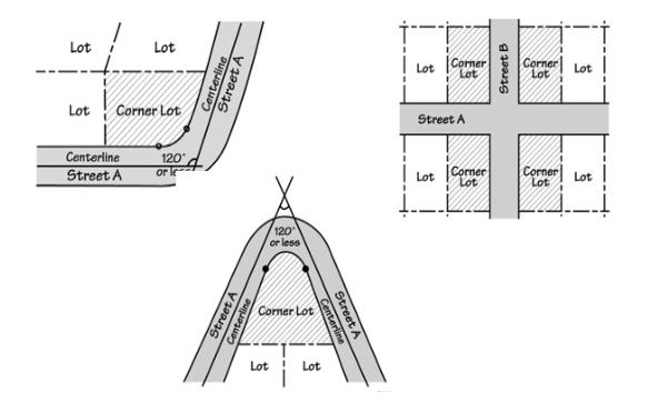
Flag Lot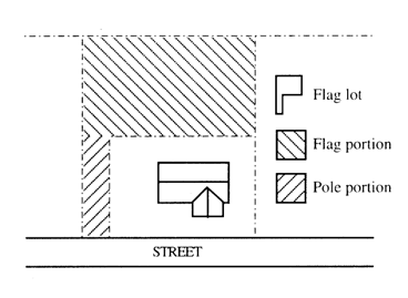
Front and Side Lot Lines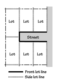
Street Lot Lines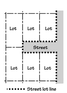
Lot Lines on Irregular Lots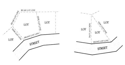
Main/Primary Building Entrance. A main entrance is the entrance to a building that most pedestrians are expected to use. Generally, each building has one main entrance; however, some buildings may have more than one primary entrance or may have entrances that open directly into the building’s lobby or principal interior ground level circulation space.
“Major remodeling” means projects where the floor area or the developed area of the site increases by 10 percent or more.
“Maneuvering area” or “aisle” means the driving area in a parking lot where motor vehicles are able to turn around and access parking or loading spaces.
Manufactured and Mobile Homes. See definitions under “Dwelling.”
“Manufactured dwelling and mobile home park” (land use) means any place where four or more manufactured dwellings are located within 500 feet of one another on a lot, tract, or parcel of land under the same ownership, the primary purpose of which is to rent or lease space, or keep space for rent or lease, to any person for a charge or fee paid, or to be paid, for the rental or lease or use of facilities, or to offer space free in connection with securing the trade or patronage of such person. Manufactured dwelling park does not include a lot or lots located within an approved subdivision being rented or leased for occupancy by one manufactured dwelling per lot. See also ORS Chapter 446.
Manufacturing and Production (Land Use). Manufacturing and production firms are involved in the manufacturing, processing, fabrication, packaging, or assembly of goods. Examples include processing of food and related products; breweries and distilleries when not accessory to a commercial use; slaughterhouses or meat packing; taxidermist; lumber mills, pulp and paper mills, and other wood products manufacturing; woodworking, including cabinet makers; production of chemical, rubber, leather, clay, bone, plastic, stone, or glass materials or products; concrete batching and asphalt mixing; production or fabrication of metals or metal products, including enameling and galvanizing; manufacture or assembly of machinery, equipment, vehicles, appliances; sign making; production of prefabricated structures, including mobile homes; and the production of energy.
“Mixed-use” means the combination of residential uses with commercial (e.g., office, retail, or services), civic, or light industrial uses on a site.
“Modifications” or “adjustments” means that limited relief from the standards of HMC Titles 18 and 19 as described and defined in Chapter 19.30 HMC.
Multifamily Development and Structure. See definitions under “Dwelling.”
“New construction” means a new structure constructed for the purpose of human occupancy, employment, recreation, etc., including placement of a manufactured dwelling or other similar dwellings.
“Nonconforming development” means an element of a development, such as lot area, setback, height, lot coverage, landscaping, sidewalk, or parking area, or lack thereof, that was created in conformance with development regulations but which subsequently, due to a change in the zone or applicable code standards, is no longer in conformance with the current applicable development regulations. See Chapter 18.25 HMC.
“Nonconforming situation” means a nonconforming development or nonconforming use. A situation may be nonconforming in more than one aspect. For example, a site may contain a nonconforming use and also have some nonconforming development. See also “Nonconforming development” and “Nonconforming use.” See Chapter 18.25 HMC.
“Nonconforming use” means a use that was allowed by right when established or a use that obtained a required land use approval when established, but that subsequently, due to a change in the zone or zoning regulations, the use or the amount of floor area of the use is now prohibited in the zone. See Chapter 18.25 HMC.
Office (Land Use). Office uses are characterized by activities conducted in an office setting and generally focusing on business, government, professional, medical, or financial services.
“Off-street parking” means all off-street areas designed, constructed, used, or required, or intended to be used, for the parking of motor vehicles. See Chapter 18.80 HMC for parking standards.
“On-street parking” means parking in the street right-of-way, typically in parking lanes or bays, when allowed by the applicable roadway authority. See Chapter 18.80 HMC for parking standards.
“Orientation” means to cause to face toward a particular point of reference (e.g., a building oriented to the street).
“Owner” means the owner of the title to real property or the contract purchaser of real property of record, as shown on the latest assessment records in the office of the County Assessor. Owner also includes a deed holder or contract purchaser whose name does not appear in the latest assessment records, but who presents to the City a copy of a deed or contract of sale signed by the owner of record.
“Parcel” means a legally defined area of land created through a partition.
“Parking area” means all the area devoted to the standing, maneuvering, and circulation of motor vehicles. Parking areas do not include driveways or areas devoted exclusively to nonpassenger loading or fire apparatus lanes.
“Parking lot perimeter” means the boundary of a parking lot area that usually contains a landscaped buffer area.
“Parking space” means an improved space designed to provide standing area for a motor vehicle. See Chapter 18.80 HMC for parking space standards.
Parking Versus Storage. Parking is to leave a motor vehicle for a temporary time. Storage is to place or leave in a location for storage, maintenance, repair, future sale, or rental, or future use for an indefinite period of time.
Parks and Open Space (Land Use). Parks and open space areas are public parks or private common areas consisting mostly of recreational facilities, community gardens, or natural areas.
“Partition (major)” means to divide an area or tract of land into three or fewer parcels within a calendar year when such area or tract of land exists as a unit or contiguous units of land under single ownership at the beginning of such year. See ORS 92.010(8).
“Partition (minor)” means to divide an area or tract of land into two or three parcels within a calendar year when such area or tract of land exists as a unit or contiguous units of land under single ownership at the beginning of such year. See ORS 92.010(8).
“Partition plat” means final map and other writing containing all the descriptions, locations, provisions, and information concerning a major or minor partition.
“Pathway” means a walkway, bikeway, or access way conforming to City standards and separated from the street right-of-way, which may or may not be within a public right-of-way.
“Paving” or “paved” means any natural surface covered with concrete, asphalt, brick, paving stones, or other hard surface materials, including semi-permeable materials.
“Pedestrian way” means a right-of-way for pedestrian traffic.
“Person” means every natural, firm, partnership, association, social or fraternal organization, corporation, estate, trust, receiver, syndicate, branch of government, or any other group or combination acting as a unit.
“Planned road or street” means a highway, road, street, or alley identified in an adopted corridor plan, comprehensive plan or transportation system plan in accordance with administrative procedures of OAR 660-012 and ORS Chapter 197, but that has not been constructed.
“Planning Commission” means the Planning Commission of the City.
“Planter strip” means a landscape area for street trees and other plantings within the public right-of-way, usually a continuous planter area between the street and a sidewalk.
“Plat” means diagrams, drawings, and other writing containing all the descriptions, locations, dedications, provisions, and information concerning a land division. This term includes the State law definitions of “partition plat” and “subdivision plat.” See also Chapter 19.20 HMC, Land Divisions and Property Line Adjustments.
“Posted speed” means the statutory speed established by ORS 811.105 or 811.180, or the designated speed established by ORS 810.180.
“Practicable” means capable of being done after taking into consideration reasonable cost, existing technology, and logistics in light of overall project purposes.
“Primary structure” means a structure or combination of structures of chief importance or function on a site. In general, the primary use of the site is carried out in a primary structure. The difference between a primary and accessory structure is determined by comparing the size, placement, design, appearance, and the orientation of the structures on a site.
“Primary use” means an activity or combination of activities of chief importance on the site. One of the main purposes for which the land or structures are intended, designed, or ordinarily used. A site may have more than one primary use.
“Project” means an existing or proposed use or development subject to one or more land use approvals.
“Property line” means the division of land between two units of land.
“Property line adjustment” means the relocation of a single common property line between two abutting properties not resulting in an increase in the number of lots, pursuant to Chapter 19.20 HMC. See figure below.
Property Line Adjustment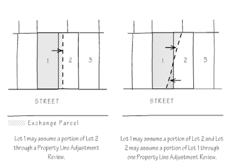
“Public access easement” means an easement granted to the public for vehicular and pedestrian access, or for nonmotorized access.
“Public improvements” means development of public infrastructure, as required by the City, a special district, or road authority, as applicable. See Chapter 18.85 HMC.
“Quasi-judicial” means an action or decision that requires substantial discretion or judgment in applying the standards or criteria of this Code to the facts of a development or land use proposal and requires a public hearing. See HMC 19.10.040.
“Radio frequency transmission facilities” (land use) includes all devices, equipment, machinery, structures, or supporting elements necessary to produce nonionizing electromagnetic radiation within the range of frequencies from 100 kHz to 300 GHz and operating as a discrete unit to produce a signal or message. Towers may be self-supporting, guyed, or mounted on poles or buildings.
“Recreational vehicle” means a vacation trailer or other unit with or without motive power which is designed for human occupancy and to be used temporarily for recreational, seasonal, or temporary purposes, and has a gross floor space of less than 400 square feet. “Recreational vehicle” includes camping trailers, camping vehicles, motor homes, park trailers, bus conversions, van conversions, tent trailers, travel trailers, truck campers and any vehicle converted for use or partial use as a recreational vehicle. The unit shall be identified as a recreational vehicle by the manufacturer or converter.
“Recreational vehicle park” (land use) means a commercial use providing space and facilities for motor homes or other recreational vehicles for recreational use or transient lodging. There is no minimum required stay in a recreational vehicle park; however, the City may establish the maximum length of stay. Uses where unoccupied recreational vehicles are offered for sale or lease, or are stored, are not included as recreational vehicle parks.
“Religious institutions and places of worship” (land use) means uses primarily providing meeting areas for religious activities; may include schools as an accessory use.
“Residential facility” is defined in ORS 443.400 to include the terms “residential care facility,” “residential training facility,” “residential treatment facility,” “residential training home,” and “residential treatment home,” and includes a facility, licensed under ORS 443.400 through 443.460, for six or more physically or mentally handicapped persons or elderly persons who need not be related. Staff persons required to meet Department of Human Resources licensing requirements shall not be counted in the number of facility residents and need not be related to each other or to any resident of the residential facility.
“Residential home” means a residence for five or fewer unrelated physically or mentally handicapped persons and for staff persons who need not be related to each other or to any other home resident.
“Residential trailer” means a structure constructed for movement on the public highways that has sleeping, cooking and plumbing facilities, that is intended for human occupancy, and that was constructed before January 1, 1962.
“Residential use” (land use) means long-term (i.e., more than 28 days) occupancy of a dwelling unit, which may be owner-occupied or rented. Occupancy of a dwelling unit for shorter periods of time is considered an overnight accommodation.
Retail Sales and Service Uses (Land Use). Retail sales and service uses sell, lease, or rent new or used products, goods, or services. They include services such as barber/salon, accountant, restaurant, bar, repair service, and similar uses. See also “Vehicle servicing.”
“Right-of-way” means real property or an interest in real property owned by a roadway authority for the purpose of constructing, operating, and maintaining public facilities.
“Roadway” means the portion of a right-of-way that is improved for motor vehicle and bicycle travel, subject to applicable State motor vehicle licensing requirements. Roadway includes vehicle travel lanes and on-street parking areas. Roadway does not include area devoted to curbs, parking strips, or sidewalks.
“Road/roadway authority” means the City or other agency (e.g., Oregon Department of Transportation, City of Harrisburg, or Linn County) with jurisdiction over a road or street.
“Schools” (land use) means public and private schools, secular or parochial, at the primary, elementary, middle, junior high, or high school level.
“Self-service storage” means mini-storage or other storage areas for individual or business uses. The storage areas are designed to allow private access by the tenant for storing personal property.
“Setback” or “setback yard” means the minimum distance required between a specified object, such as a building, and another point, measured from lot lines to a specified object. Typically, a setback refers to the minimum distance (yard dimension) from a building to a specified property line.
“Shared driveway” means a driveway used to access two or more parcels.
“Shared parking” means required parking facilities for two or more uses, structures, or lots or parcels, which are satisfied jointly with the same facilities. See Chapter 18.80 HMC.
“Sidewalk” means a paved walkway within a public street right-of-way that is generally located adjacent to and separated from the roadway by a curb, drainage facility (e.g., ditch or swale), or planter strip.
“Sight distance” means the unobstructed viewing distance measured from one object or location to another object or location, usually required for the purpose of traffic safety (e.g., a length of street or highway that a driver can see with an acceptable level of clarity, pursuant to the standards of the applicable roadway authority).
“Sign” means any outdoor device, or device visible from outdoors, providing identification, advertising, or directional information for a specific business, group of businesses, service, product, brand, person, organization, place or building. Included in this definition of signs are graphic devices such as logos and trademarks; attention- attracting objects such as wind-driven spinners, portable sign devices, logo sculptures, banners, balloons, streamers, strobe lights, flags, inflatable structures, projected picture signs, holographic projection signs, and laser projected designs/images/copy; and other attention-attracting media and devices.
Site. For land divisions, property line adjustments, and lot consolidations, the site is the lots, lots of record, parcels, or tracts proposed to be divided or reconfigured. For all other purposes, the site is an ownership except as follows:
a. If a proposed development includes multiple ownerships, then the site is the combined area of all contiguous ownerships.
b. If a proposed development includes only a portion of an ownership, and the balance of the ownership is vacant, then the applicant may choose to define the site as the portion of the ownership that is proposed for development.
c. If a proposed development includes only a portion of an ownership, and there is other development on the ownership, then the applicant may choose to define the site as the portion of the ownership that is currently developed plus the portion proposed for development.
“Site frontage” means the part of a site that abuts a street. See also “Block face” or “street frontage.”
“Spacing standards” means the minimum distance required between a proposed street or driveway connection, as applicable, and the center of the nearest existing street or driveway connection on the same side of the highway in both directions, as set forth by the standards of the applicable roadway authority. Spacing standards for State highways are contained in OAR 734-051-4020.
“Street” means an improved or unimproved public or private right-of-way that is created to provide ingress or egress for vehicular traffic to one or more lots or parcels, excluding a private drive that is created to provide ingress or egress to mid-block drives (HMC 19.20.040) or land in conjunction with the use of land for forestry, mining, or agricultural purposes. A “street” includes the land between right-of-way lines or within the ingress/egress easement areas serving multiple residential lots but excluding “flag pole” portions of flag lots. For the purposes of this code, street does not include alleys and rail rights-of-way that do not also allow for motor vehicle access, or freeways and their ramps.
“Street connectivity” is expressed as the number of street and/or access way connections within a specific geographic area. Higher levels of connectivity provide for more direct transportation routes and better dispersion of traffic, resulting in less traffic on individual streets and potentially slower speeds through neighborhoods.
“Street-facing” or “oriented to street” means a wall plane of a structure that faces or is oriented within 45 degrees or less from a street lot line.
“Street stub” means a temporary street ending where the street will be extended through adjacent property in the future, as those properties develop. Not a permanent street end or dead-end street.
“Structural alteration” means a change to the supporting members of a structure, including the supporting parts of foundations, bearing walls or partitions, columns, beams, girders, or the roof.
“Structure” means, except as provided by applicable building codes, any object constructed in or on the ground. Structure includes buildings, decks, fences, towers, flag poles, signs, utility vaults, and other similar objects. Structure does not include paved areas or vegetative landscaping materials.
“Subdivider” means a person who undertakes the subdividing of a parcel of land, including changes in street or lot lines, for the purpose of transfer of ownership or development.
“Subdivision” means to divide land into four or more lots within a single calendar year. See also Chapter 19.20 HMC, Land Divisions and Property Line Adjustments, and ORS 92.010.
“Subdivision plat” means a final map and other supplemental information containing all the descriptions, locations, specifications, dedications, provisions and other information concerning a subdivision.
“Through street” means street that connects to other streets at both ends or is planned to do so in the future, pursuant to a comprehensive plan, transportation system plan, access management plan, or land use approval.
“Topographical constraint” means where existing slopes, landforms (e.g., streams, canals, rock outcropping, etc.) or existing manmade feature (e.g., embankment or berm) make conformance with a code standard impracticable.
“Townhome” means three or more attached single-family dwellings or row houses that are individually owned.
“Tract” means a piece of land within a platted subdivision reserved for open space, utility corridor, recreation facilities, sensitive lands, or other purpose; may be dedicated to a homeowners’ association or other entity for maintenance.
“Traffic impact analysis” means a report prepared by a professional engineer that analyzes existing and future roadway conditions, and which may recommend transportation improvements and mitigation measures.
“Travel trailer” means a vacation structure or self-propelled vehicle equipped with wheels for street or highway use; intended for human occupancy; equipped with plumbing, sink, or toilets; used for vacation and recreational purposes; and not used as a residence. See ORS 446.003(5), (24), and “Recreational vehicle.”
“Turnaround” means a vehicle maneuvering area at the end of a dead-end street (e.g., hammerhead, cul-de-sac, or other configuration) that allows for vehicles to turn around.
“Use” (land use) means the purpose for which land or a structure is designed, arranged, intended, occupied, or maintained.
Utilities. For the purposes of this code, there are two types of utilities: (a) private: telephone, electric, telecommunication, and similar franchise facilities; and (b) public: water and wastewater conveyance and treatment facilities.
“Utilities” (land use) means infrastructure services, which need to be located in or near the area where the service is provided. Basic utility uses may or may not have regular employees at the site. Services may be publicly or privately provided. Examples include water and sewer pump stations; sewage disposal and conveyance systems; electrical substations; water towers and reservoirs; water quality and flow control facilities; water conveyance systems; storm water facilities and conveyance systems; telephone exchanges; suspended cable transportation systems; public safety facilities; district heating and cooling systems; solar, wind, or geothermal power generation facilities that are not accessory to a primary use; and emergency communication broadcast facilities. Larger-scale utility facilities, and those that do not conform to the above definition (e.g., biomass power generation), may be classified as industrial uses or “other” uses (e.g., utility corridor) as applicable.
“Variance” means a Planning Commission decision to lessen or otherwise modify the requirements of this code. See Chapter 19.40 HMC.
“Vehicle areas” means all of the areas on a site where vehicles may circulate or park, including parking areas, driveways, drive-through lanes, and loading areas. See also “Driveway” and “Parking area.”
“Vehicle repair” means repair of passenger vehicles, trucks or other motor vehicles such as motorcycles, boats and recreational vehicles.
“Vehicle servicing” means gas stations, unattended card key stations, car washes, commercial vehicle maintenance and/or oil and lubrication services, and similar uses.
“Vision clearance area” means areas near intersections of roadways and motor vehicle access points where a clear field of vision is required for traffic safety and to maintain adequate sight distance. See Chapter 18.70 HMC.
“Walkway” means a sidewalk or path, including any access way, improved to City standards, or to other roadway authority standards, as applicable. See also “Access way,” “Pathway,” and “Sidewalk.”
“Warehouse,” “freight movement” and “distribution” mean the storage or movement of goods, except as accessory to a primary permitted use on the subject site.
Waste-Related Use. Waste-related uses are characterized by uses that receive solid or liquid wastes from others for disposal on the site or for transfer to another location, uses that collect sanitary wastes, or uses that manufacture or produce goods or energy from the biological decomposition of organic material. Waste-related uses also include uses that receive, store, sort, and distribute post-consumer recyclable materials; and those that receive hazardous wastes from others and are subject to the regulations of OAR 340-100-110, Hazardous Waste Management.
“Waste/trash collection areas” includes areas set aside or designed to be used for garbage collection and collection of materials for recycling. Waste collection areas include areas occupied by dumpsters and other solid waste receptacles.
“Wireless communication equipment” means cellular towers, antennas, monopoles, and related facilities used for radio signal transmission and receiving.
“Yard” means the area defined by setbacks (i.e., between the setback line and nearest property line).
“Yard, front” means a yard between side lot lines and measured horizontally at right angles to the front lot line to the nearest point of the building.
“Yard, rear” means a yard extending between side lot lines and measured horizontally at right angles to the rear lot line, from the rear lot line to the nearest point of the building.
“Yard, side” means a yard between the front and rear yards measured horizontally and at right angles to the side lot line, from the side lot line to the nearest point of the building.
“Zoning Official” means an individual or committee designated by the City of Harrisburg with the duties and authority to enforce the provisions of this title. [Ord. 1002 § 2 (Exh. B), 2024; Ord. 987 § 1 (Exh. A), 2022.]