


Chapter 17.52
SUPPLEMENTARY REGULATIONS AND EXCEPTIONS
Sections:
17.52.010 Accessory uses – General provisions.
17.52.050 Storage in front setback area.
17.52.060 Clear-vision area requirement.
17.52.080 Maintenance of minimum requirements.
17.52.160 Required setbacks – Exceptions.
17.52.170 Solid waste, garbage, trash, recycling, and composting receptacle storage areas.
17.52.180 Placement and screening of mechanical equipment.
17.52.190 Building height limitations.
17.52.200 Building height limitations – General exception.
17.52.220 Tree protection and removal.
17.52.230 Public infrastructure improvement requirements.
17.52.300 Traffic impact study (TIS) requirements.
17.52.010 Accessory uses – General provisions.
Accessory uses shall comply with all requirements for the principal use except where specifically modified by this title, and shall comply with the following limitations:
A. Repealed by Ord. 2010-04.
B. A greenhouse or hothouse may be maintained accessory to a dwelling, provided the activity does not exceed that which requires a license under ORS Chapter 571, Nurseries and Nurserymen.
C. A guest house may be maintained accessory to a dwelling, provided there are no portable, temporary, or permanent cooking facilities in the guest house.
D. Repealed by Ord. 2010-04.
E. A home occupation shall not occupy more than one-quarter of the ground floor area of the dwelling. The residential character of the building shall be maintained and the activity shall not have the outward appearance of a business nor detract from the residential character of the neighborhood. There shall be no outside display or storage of merchandise, materials, signs or equipment on the premises. Noise, odor, smoke, gases, fallout, vibration, heat or glare resulting from the home occupation shall not be detectable beyond the limits of the property. (Ord. 2020-15 § 6; Ord. 2010-04 §§ 1, 2; Ord. 84-2 § 4.010)
17.52.020 Authorization of similar uses.
Repealed by Ord. 2020-15. (Ord. 2000-06-A § 1; Ord. 90-8 § 1; Ord. 84-2 § 4.020)
17.52.030 Access requirement.
Every lot shall abut a street, other than an alley, for at least 25 feet. (Ord. 84-2 § 4.030)
17.52.050 Storage in front setback area.
Boats, RVs, trailers and house trailers shall not be stored in a required front setback area. (Ord. 2020-15 § 8; Ord. 84-2 § 4.050)
17.52.060 Clear-vision area requirement.
A. Requirement to Provide Clear Vision. For public safety purposes, all properties shall have triangular clear-vision areas (aka clear-vision triangles) where streets (public or private) intersect with other streets, commercial alleys and commercial driveways. Clear-vision triangles shall also be provided for street intersections with commercial driveways as provided herein. Clear-vision areas at local intersections shall meet the requirements in this section, which are meant to be adequate to allow drivers and pedestrians who are stopped or approaching with caution to see intersecting traffic in time to avoid collisions. Clear-vision areas at intersections with Highway 101 must meet with Oregon Department of Transportation approval and comply with the requirements of this section.
B. Definition of a Clear-Vision Triangle. This section defines a clear-vision triangle differently for (1) controlled intersections, where at least one street has a stop sign or traffic control light; (2) for uncontrolled intersections; and (3) in commercial zones, for alleys and driveways. The definitions for clear-vision triangles at the intersections of two streets use “Point A,” which is the point of intersection of the lot lines (the property corner), or in the case of a curved lot line, the intersection of the tangents of the endpoints of the curve (Figure 17.52.060-1).

Figure 17.52.060-1: Point A for a curved lot line.
1. For intersections controlled by a stop sign or traffic light and for T intersections, two sides of the triangle are aligned with the property lines of the corner lot. The side of a triangle that abuts a controlled street or a street that does not continue on the other side of the intersection (ending in a T intersection) shall extend along the right-of-way of the controlled street 10 feet from point A. The side of the triangle abutting an uncontrolled street shall extend 50 feet from point A. The third side shall connect the endpoints of the other two sides. (Figure 17.52.060-2.)
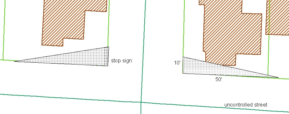
Figure 17.52.060-2: Clear-vision triangle at controlled intersection.
2. For Uncontrolled Intersections. A corner lot that abuts two uncontrolled streets shall have a triangle for each abutting street, defined by the following sides: a side extending along the right-of-way of one street 10 feet from point A; a side extending along the right-of-way of the intersecting street 50 feet from point A; and a side connecting the endpoints of the other two sides. (Figure 17.52.060-3.)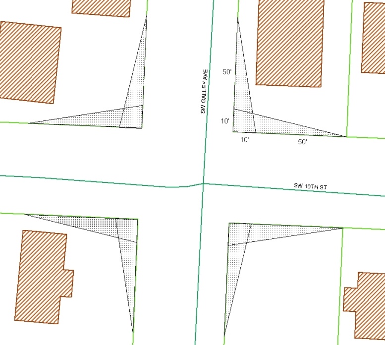
Figure 17.52.060-3: Clear-vision triangles at uncontrolled intersection.
3. Alleys and Driveways in Commercial Zones. Property owners shall maintain a clear-vision triangle on each side of a commercial driveway. One side of the triangle shall be along the edge of the commercial driveway extending 10 feet from the point of intersection with the right-of-way line. A second side along the right-of-way line shall extend from the point of intersection with the edge of the commercial driveway 50 feet. The third side shall connect the endpoints of the other two sides. (Figure 17.52.060-4.)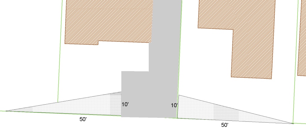
Figure 17.52.060-4: Clear-vision triangles for commercial driveways.
4. Notwithstanding the definitions set forth above, the minimum clear-vision area (clear-vision triangle) may be modified by the city engineer, with the concurrence of the director, upon written finding that more or less sight distance is necessary (i.e., due to traffic speeds or roadway alignment).
C. Clear-Vision Requirements. Clear-vision triangles shall be free of obstructions (including but not limited to plantings, fencing, or other temporary or permanent obstruction) from two-and-one-half feet to eight feet above the grade of the street, except for obstructions specified in subsection (D) of this section.
D. Exceptions. The following obstructions to clear vision may be within the clear-vision areas required by this section, unless the obstruction is identified by the city engineer and planning director as creating an unacceptable hazard:
1. Trees existing in the location prior to May 28, 2014, if limbed to at least eight feet. Trees in the clear-vision area may not be replaced.
2. Topographical features (e.g., inclines, retaining walls) existing as of May 28, 2014, or, for newer development, as determined by the city engineer and director as necessary or unavoidable.
3. Principal buildings, accessory buildings, and structures existing as of April 24, 2014. Notwithstanding the above, a legally nonconforming principal building is not subject to removal based on the hazard exception.
4. Fences Existing as of May 28, 2014. New fences that are at least 75 percent open (e.g., wire or chain link) may be within clear-vision triangles.
5. Existing driveways and existing required parking spaces may be in the clear-vision area. New required parking spaces shall be outside the clear-vision triangle. New driveways should be outside the clear-vision areas. New garages to be accessed by driveways that cross over clear-vision areas must be set back at least 20 feet from the clear-vision area.
6. Utilities existing as of May 28, 2014.
7. Public traffic signs. (Ord. 2022-25 §§ 43, 44; Ord. 2014-05 § 1; Ord. 84-2 § 4.060)
17.52.070 Measurement of clear-vision areas.
Repealed by Ord. 2014-05. (Ord. 84-2 § 4.070)
17.52.080 Maintenance of minimum requirements.
No lot area, minimum setback area, open space, or off-street parking or loading area existing on or after the effective date of the ordinance codified in this title shall be reduced below the minimum required for it by this title. (Ord. 2020-15 § 9; Ord. 84-2 § 4.080)
17.52.090 Dual use of required open space.
Repealed by Ord. 2020-15. (Ord. 92-8 § 11; Ord. 84-2 § 4.090)
17.52.100 Landscaping.
Repealed by Ord. 2022-15. (Ord. 2015-10 §§ 5, 6; Ord. 2010-06 § 10)
17.52.110 Distance between buildings.
Repealed by Ord. 2020-03. (Ord. 84-2 § 4.110)
17.52.120 Utilities.
In all zones, all electrical, telephone and cable television utility service installations or connections made as part of new construction of a building or structure shall be placed underground in accordance with city standards. (Ord. 2022-25 § 45; Ord. 2020-15 § 11; Ord. 95-15 § 11; Ord. 91-1 § 1; Ord. 84-2 § 4.120)
17.52.130 Projections from buildings.
Repealed by Ord. 2010-04. (Ord. 84-2 § 4.130)
17.52.140 Lot size requirements – General exceptions.
Repealed by Ord. 2011-03. (Ord. 84-2 § 4.140)
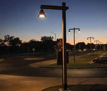
17.52.150 Exterior lighting.
Artificial exterior lighting shall not be designed to shine or create glares in any residential zone or residential use, adjacent dwelling unit or in a public right-of-way.
A. Light poles must not exceed a height of 20 feet.
B. All lighting must be shielded to avoid glare, light pollution (night sky), and light spillover onto residential properties. Shielding must be integral to the light fixture and direct light downward.
C. Luminance at the property line, or no more than five feet over the property line, must be zero.
D. Maximum initial luminance of outdoor sales displays, outdoor storage areas, service station canopies, and similar areas must not exceed 20 foot-candles.
E. Maximum initial luminance of parking lots must not exceed four foot-candles.
F. Up-lighting is prohibited. The maximum illumination limits for wall washing are one foot-candle for dark colored surfaces and one-half foot-candle for light colored surfaces.
G. Pedestrian ways and building entrances not otherwise illuminated by building-mounted lights or streetlights must provide between one and two foot-candles of light from bollards, step lights, or other low-profile fixtures that are appropriate for walkways and plazas.
H. The manufacturer’s data or measurement must demonstrate conformance with this section. Cut sheets, a photometric plan analysis, and an exterior lighting plan showing the locations, types, sizes, and heights of all exterior lighting fixtures shall be included with the applicable application submittal.
Figure 17.52.150-1. Examples of exterior lighting and photometric plan.
|
|
|
|
Full cut-off lighting illuminating parking and pedestrian connection. (Credit: landscapeonline.com) |
Example photometric or lighting plan detail. (Credit: beamltd.com). |
(Ord. 2020-10 § 12; Ord. 84-2 § 4.150)
17.52.160 Required setbacks – Exceptions.
A. Architectural Features. Architectural features such as cornices, eaves, canopies, sunshades, gutters, chimneys, flues, awnings, and bay windows may project up to 18 inches into a required setback area.
B. Accessory Structures. A required side or rear setback may be reduced to three feet for an accessory structure, provided the structure is detached from other structures by five feet or more and does not exceed a height of one story nor an area of 200 square feet.
C. Fences. Fences in any zone except the R1RE zone, within required setback areas up to and on the property line, may not exceed seven feet in height nor conflict with requirements of a clear vision area as provided in LCMC 17.52.060 or the clear vision areas of adjacent private driveways.
1. Fences in the R1RE zone may not exceed three and one-half feet in height in a required front setback area or required street side setback area, or more than six feet in height in any other required setback area. Fences in the R1RE zone may not conflict with the requirements of a clear vision area as provided in LCMC 17.52.060 or the clear vision areas of adjacent private driveways.
D. Retaining Walls. Retaining walls may be constructed in required setback areas, subject to the following limitations:
1. One or more retaining walls, none of which individually exceeds six feet in height, may be used, in front or street side setback areas, provided each successive wall is set back or stepped from the next lowest wall at least one foot for each one foot of height for that wall;
2. Within interior side and rear setback areas a retaining wall may be constructed up to eight feet in height;
3. All building code and structural permitting requirements shall be met prior to construction of any retaining wall.
E. Disabled Access Facilities. Disabled access facilities may be constructed in required setback areas as additions to existing buildings if they do not conflict with the clear vision requirements of LCMC 17.52.060. For purposes of this section disabled access facilities include ramps, sidewalks, curbing and entrances constructed for the purpose of making a building accessible to a disabled person. Disabled access facilities must be constructed in accordance with any applicable requirements of the building code in effect at the time of their construction. Disabled access facilities constructed as additions to a nonconforming structure shall not be considered an alteration or extension of the nonconforming structure.
F. Bridges. Unenclosed and uncovered pedestrian or vehicular bridges for access to a dwelling may be constructed in a required setback area.
G. Porches, Decks, and Stairs. Unenclosed and uncovered porches, decks, and stairs may be constructed in a required setback area, provided no part of the porch, deck, or stairs is more than 30 inches above the ground or otherwise requires a building permit. (Ord. 2023-20 § 3; Ord. 2022-25 § 47; Ord. 2020-15 § 12; Ord. 2016-08 § 1; Ord. 2010-04 § 4)97
17.52.170 Solid waste, garbage, trash, recycling, and composting receptacle storage areas.
All solid waste, garbage, trash, recycling, and composting receptacles shall be located within a building or within an enclosure which screens the receptacle from the view of adjacent property and from right-of-way, except those receptacles associated with a detached single-unit dwelling, attached single-unit dwelling, duplex, or manufactured home. (Ord. 2022-25 § 48; Ord. 2020-13 § 26; Ord. 84-2 § 4.170)
17.52.180 Placement and screening of mechanical equipment.
A. Any heating, air conditioning, or other mechanical equipment installed on or near a building to be used to serve the building or a function performed therein, and any propane tanks, shall be screened from the ground level view from adjacent property and from right-of-way, except those associated with a detached single-unit dwelling, attached single-unit dwelling, duplex, or manufactured home.
B. Rooftop mechanical units shall not exceed the allowable building height.
C. Ground-mounted mechanical units shall be limited to the sides or rears of buildings and screened from view from adjacent property and from right-of-way.
D. Standpipes, meters, vaults, and similar equipment shall not be placed on a front elevation unless there is no other option. (Ord. 2022-25 § 49; Ord. 2020-13 § 27; Ord. 98-11 § 4; Ord. 84-2 § 4.180)
17.52.190 Building height limitations.
A. No structure used for human habitation that exceeds 45 feet in height shall be permitted in any zone unless consent is first approved by the voters of the city at a regular or special election. For the purpose of this section, “height” means the average vertical distance from the grade at the center of all walls of the building to the highest point of the roof, excluding those excepted in LCMC 17.52.200.
B. No structure that exceeds 35 feet in height shall be permitted in a residential zone within 500 feet of any shoreline without prior approval as a Type III procedure.
C. No structures used for human occupancy shall be permitted to exceed the building height limitations of the zones in which they are located. To ensure that this standard is met the following rules apply:
1. Building permit applications must include elevations of all exterior walls of the proposed structure showing:
a. The line of the approved grade in the plane of the wall; and
b. The highest part of the structure.
2. The grade may not rely on retaining walls, riprap, other artificial restraints, or berming to increase elevation at the point of height measurement.
3. For the purposes of this subsection, “approved grade” means:
a. The existing grade, meaning one of the following:
i. The ground level before any human disturbance as shown by survey or other reliable evidence; or
ii. The ground level shown on the city’s 2018 LIDAR data (which is available from the department); or
iii. If the proposed building site has existing structures or other disturbances to the land that existed lawfully prior to October 1, 2010, the ground level established when the structure or disturbance was created (which may be determined by any of the above means); or
iv. If there has been grading on the proposed building site, without a grading permit, the director, in consultation with the city engineer, will determine the existing grade.
b. The grade shown on a grading plan approved as a part of one of the following:
i. A final master plan for a planned unit development under LCMC 17.77.120; or
ii. A partition or subdivision under Chapter 16.08 LCMC; or
iii. A development review under LCMC 17.77.070; or
iv. A conditional use permit under LCMC 17.77.060; or
v. A grading plan under Chapter 12.08 LCMC; or
vi. A building permit for a structure not subject to any of approvals in subsections (C)(3)(b)(i) through (v) of this section. (Ord. 2022-25 § 46; Ord. 2022-15 § 35; Ord. 2020-15 § 13; Ord. 2010-04 § 5; Ord. 84-2 § 4.190)
17.52.200 Building height limitations – General exception.
Projections such as chimneys, spires, domes, elevator shaft housing, towers, aerials, flagpoles, and other similar objects not used for human occupancy are not subject to the building height restrictions of this title. (Ord. 2010-04 § 6; Ord. 84-2 § 4.200)
17.52.210 Planned unit development (PUD).
Repealed by Ord. 2020-15. (Ord. 2020-10 § 9; Ord. 2012-06 § 10; Ord. 2008-14 § 2; Ord. 96-7 § 1; Ord. 91-13 § 1; Ord. 84-2 § 4.210)
17.52.220 Tree protection and removal.
A. Scope. This section applies to all trees within the city wherever located.
B. Purpose. This purpose statement provides a general philosophy to guide the specific enforcement and implementation of provisions and criteria in this section.
1. Value of Trees. The city benefits from trees. Trees of varied types add to the aesthetic beauty of the community and provide important environmental benefits including: help clean the air, help control erosion, maintain water quality and provide noise barriers.
2. Intent. The intent of this section is to protect trees where appropriate, including taking reasonable measures in development to avoid tree removal, and to prohibit damage, mutilation, and
destruction of valuable trees. Protection of trees is preferred over replacement. This section aims to:
a. Establish regulations to protect trees;
b. Encourage the preservation of trees in the city;
c. Require the preservation of trees on property subject to development approval;
d. Set standards for removal of trees;
e. Control problems of soil erosion, destruction of scenic values and wildlife habitats;
f. Improve air quality;
g. Protect water quality; and
h. Protect land from erosion.
3. Need for Exceptions. The city recognizes that, at the time of development, removing certain trees may be necessary to accommodate structures, streets, utilities, and other needed or required improvements within the development. The burden of proof is on the applicant to show removal is necessary, and that other alternatives are not feasible. Cost shall not be the sole factor in determining whether an alternative is feasible.
C. Definitions. The following definitions apply to regulations governing the preservation and removal of trees contained in this section exclusively:
“Arborist, certified” means a licensed tree care consultant, who is certified as an arborist by the International Society of Arboriculture, or other arborist approved by the city.
“Canopy cover” means the area above ground that is covered by the trunk and branches of the tree.
“Commercial forestry” means the removal of 10 or more trees per acre per calendar year for sale. Tree removal undertaken by means of an approved tree removal plan under subsection (F) of this section is not considered commercial forestry under this definition.
“Cut” means to fell or remove a tree or to do anything that has the natural result of causing the death or substantial destruction of a tree, including girdling and topping.
“Development” means grading, excavation, fill, or construction on a site requiring development review, conditional use approval, subdivision approval, or planned unit development approval.
“Diameter” means diameter of tree measured at four and one-half feet above grade on the uphill side. In the case of multi-stemmed or trunked trees, the diameter shall be the sum of diameters of all individual stems or trunks, measured at a point no more than six inches above the surrounding grade or measured six inches from the point where the stems digress from the trunk, whichever produces the larger measurement. If a tree has been removed and only a stump shorter than four and one-half feet remains, diameter shall be measured as the diameter of the top of the stump.
“Girdling” means the cutting or removal of the outer bark and conducting tissues of a tree, potentially causing death by interrupting the circulation of water and nutrients.
“Hazardous tree” means a tree that by reason of emergency conditions, disease, infestation, age, or other condition presents a known and immediate hazard to persons or to public or private property.
“Pruning” means the cutting or trimming of a tree in a manner consistent with recognized tree maintenance practices.
“Removal” means cutting or removing 50 percent or more of the crown, trunk or root system of a tree, or any action that results in the loss of aesthetic or physiological viability or causes the tree to fall or be in immediate danger of falling. “Removal” includes topping, but shall not include pruning performed to applicable standards.
“Significant natural resource areas” means those lands described in Chapter 17.46 LCMC.
“Topping” means the severe cutting back of the tree’s crown limbs to stubs to such a degree so as to remove the natural canopy and disfigure the tree.
“Tree” means a perennial woody plant, typically of eight feet or more in height, with a single main stem (the trunk or bole), or in some cases, multiple trunks, from which branches and twigs extend to form a characteristic crown of foliage.
“Large tree” includes any tree that has a trunk at least six inches in diameter (see definition of diameter).
“Mitigation tree” includes any tree required by this section as a replacement for a tree removed.
“Protected tree” includes any tree preserved in a tree protection or landscape plan, any tree planted as mitigation for removed trees, any tree planted to fulfill a requirement of the city code, and any tree planted to replace protected trees that died or were removed.
D. Tree Removal Prohibitions.
1. Tree removal is prohibited, except as allowed in this section. Violations of this section are enforceable as Class B violations.
2. Topping is prohibited, except where necessary for utility work or public safety, in which case it requires a tree removal permit. The burden of proof is on the applicant to demonstrate in the permit application that topping is necessary, the only means of accomplishing the task, and preferable to removal. The city will rely on the most recent version of the ANSI A300 Standards for Tree, Shrub, and Other Woody Plant Maintenance to distinguish topping from pruning, and will keep a copy of the publication at the planning and community development department for review.
3. Removal of protected trees is prohibited. Protected trees must be maintained according to applicable tree protection plans, CC&Rs (conditions, covenants and restrictions), and other recorded agreements.
4. Removal of trees in wetlands that fall under the jurisdiction of state or federal government removed without concurrence from those state and/or federal agencies that have jurisdiction is prohibited.
5. Removal of trees as part of commercial forestry operations, as described in this section, is prohibited, and commercial forestry is not permitted, except as specifically allowed by this section.
E. When Tree Removal Is Allowed Without a Tree Removal Permit.
1. Generally.
a. In all cases, removal of trees must be conducted in a manner consistent with LCMC 12.08.050(B), which regulates land-disturbing activities.
b. Removal of trees less than six inches in diameter is permitted without a tree removal permit, unless they are protected trees.
2. Single-Family Dwellings and Duplexes or Two-Family Dwellings, and Attached Single-Family Dwellings. Removal of trees is allowed without a permit on a lot developed with a single-family dwelling, duplex or two-family dwelling, or attached single-family dwelling, provided:
a. The lot is not capable of further land division due to size or configuration, or if the lot is capable of further division, trees to be removed are within 100 feet of the dwelling; and
b. No protected tree may be removed without a permit, except that any tree planted to fulfill the landscaping requirements in Chapter 17.55 LCMC for lots with single- and two-family dwellings may be removed, if replaced by a plant or plants with equal plant unit value, as described in Chapter 17.55 LCMC.
3. Public Utilities and Public Works.
a. Removal of trees is allowed without a permit if performed by utility or city public works personnel to remove vegetation and trees that present a danger to life or property, to restore utility services, or to reopen a public thoroughfare to traffic.
b. Removal of trees is allowed without a permit if performed by city public works personnel to remove trees that are deemed nuisances under Chapter 8.12 LCMC, Nuisances, or to remove trees necessary to install or maintain improvements on parklands, streets, sewers, or utilities within publicly owned and dedicated rights-of-way or public utility easements.
4. Dangerous and Nuisance Trees. Removal of a tree that is a hazard or a nuisance, affecting public safety as defined in LCMC 8.12.080, as demonstrated to the satisfaction of the director of planning and community development in consultation with the city engineer, as applicable to the circumstances.
F. When a Tree Removal Permit Is Required. Except as allowed in subsection (E) of this section, no person shall engage in or cause land clearance or tree removal without first having obtained a tree removal permit issued by the city.
1. A tree removal permit may be issued only for:
a. Single-Family Dwellings, Duplexes, Two-Family Dwellings, and Attached Single-Family Dwellings. Removal of trees is allowed with a permit on a lot adjacent to a lot developed with a single-family dwelling, duplex or two-family dwelling, or attached single-family dwelling, provided:
i. The adjacent lot is owned by the owner of the developed lot or the owner of the developed lot has written permission from the owner of the adjacent lot, and the trees to be removed are within 100 feet of the dwelling; and
ii. No protected tree may be removed, except that any tree planted to fulfill the landscaping requirements in Chapter 17.55 LCMC for lots with single- and two-family dwellings may be removed, if replaced by a plant or plants with equal plant unit value, as described in Chapter 17.55 LCMC.
b. Multifamily Dwellings, Commercial or Industrial Sites, Undeveloped Sites, Trees More Than 100 Feet from Single-Family Dwellings and Duplexes or Two-Family Dwellings, and Attached Single-Family Dwellings on the same lot. Removal of trees is allowed with a permit for the following reasons only:
i. Diseased or Dead. Removal of dead trees or diseased tree(s) weakened by age, storm, fire or other injury. If a visual inspection by the city staff cannot establish that the tree is dead or diseased, the applicant shall, at the applicant’s cost, obtain the services of a certified arborist to make that determination. If the arborist determines that the tree is dead or diseased and cannot be saved, the director of planning and community development shall approve its removal;
ii. Solar Access. Removal of tree(s) to allow solar access to the south face of buildings during solar heating hours, taking into account latitude, topography, microclimate, existing development, existing vegetation, and planned uses and densities, which cannot be accomplished by pruning as demonstrated by an appropriate professional;
iii. Surveyor Access. Selective removal of tree(s) and vegetation to allow reconnaissance surveys, topographical determinations of a project site, coring to permit geotechnical evaluation and soil surveys, and similar efforts, to the extent the applicant demonstrates such removal is necessary to perform such surveys;
iv. Spread of Disease, Insects and Threat of Natural Hazard. Where removal is necessary to prevent the spread of disease or insects declared to be a nuisance by a government agency or certified arborist, or to correct or eliminate a verified natural hazard to the property owner, surrounding properties, or the community at large;
v. Selective Thinning on Open Space and Park Zoned Land. Where crowding is impairing the health and vigor of trees as determined by an appropriately qualified forester, after notice and hearing pursuant to LCMC 17.76.020 and 17.76.030 the city council may allow selective thinning on property zoned open space or park according to an acceptable maintenance plan to improve the health of the forest and using the lowest impact forestry methods practical;
vi. Development. Removal of tree(s) for the placement of structures and other improvements, in accordance with subsection (F)(9) of this section and provided:
(A) The city has approved a development review, subdivision, planned development or building permit; and
(B) The city has approved a tree protection plan, if required by subsection (H) of this section.
2. Conditions. The city may place conditions on any tree removal permit as appropriate to assure that the tree removal is conducted in a manner consistent with this section and LCMC 12.08.050(B), which regulates land disturbing activities. Where conditions of a permit conflict with requirements of this section, the more restrictive shall apply.
3. Review Process. If part of a project that requires subdivision review, development review, or a conditional use permit, the permit for tree removal shall be processed as part of development or conditional use permit review. Other tree removal applications shall be reviewed by the director of planning and community development, who may require an erosion control plan to determine conformance with Chapter 12.08 LCMC, Grading and Erosion Control, and rules issued by the public works department.
Where a tree protection plan is required for development review, the city shall not issue a tree removal permit until the applicant has demonstrated compliance with all conditions of the development approval that are required to be met prior to the start of any land clearing, grading, or construction.
4. Fee. The city council may adopt by resolution a fee to cover the actual or average costs of reviewing or issuing a tree removal permit.
5. Authority. The city manager or the city manager’s designee, including the director of planning and community development in the case of development approval, or the public works director in the case of a public works permit, is authorized to issue, extend, enforce, and revoke a tree removal permit.
6. Permit Notice and Appeal.
a. The city shall provide notice of decision or hearing in conjunction with the required notice for subdivision, partition, site development review, planned development or conditional use and in accordance with Chapter 17.76 LCMC, Prodecures. Notice shall not be required for other tree removal permits.
b. Appeals of a tree removal permit shall be as provided in this title for quasi-judicial land use decision. Administrative decisions by the director of planning and community development may be appealed to the planning commission, which shall be the final appeal. Decisions of the planning commission, not including appeals of administrative decisions, may be appealed to the city council in the same manner as provided for in Chapter 17.76 LCMC.
c. The city shall not issue a tree removal permit approved in conjunction with a development review until the time allowed for appeals has passed and no appeal has been filed, or after all appeals have been exhausted. The timely filing of an appeal shall have the effect of suspending the issuance of a permit pending the outcome of the appeal.
7. Display of Permit – Inspection. The tree removal permit shall be kept on site during permitted activities. The permit grantee shall allow city representatives to enter and inspect the premises at any reasonable time, and failure to allow inspection shall constitute a violation of this section.
8. Duration. A tree removal permit shall be effective for 18 months from the date of approval. Upon written request by the applicant prior to the expiration of the existing permit, a tree removal permit shall be extended for a period of up to one year if the approval authority finds that the applicant is in compliance with all prior conditions of permit approval and that no material facts stated in the original application have changed.
9. Tree Removal for Development. Removal of tree(s) for the placement of structures and other improvements shall comply with the following:
a. Timing of Permit Issuance.
i. Building. A permit for tree removal from individual building lots shall be issued in conjunction with, and not prior to, issuance of the building permit.
ii. Infrastructure. A tree removal permit may not be issued under this subsection for removal for installation of street, gutter, curb, sidewalk, sanitary sewer, storm sewer, and water system improvements until the city engineer has given final approval to the design of the improvements and to the grading and erosion control plans, and, to the extent otherwise required by this section or this code, the owner has entered into a public infrastructure improvement agreement for the improvements and provided financial security therefor, including for tree mitigation; and the director of planning and community development has approved a tree protection and mitigation plan, if required.
iii. Phased Developments. For phased developments, a separate tree removal permit is required for each phase of infrastructure development, which will not be issued until such time as public works approves commencement of grading for the phase. Tree removal permits issued for infrastructure development shall apply only to the minimum area necessary to accommodate the improvements.
b. Tree removal shall conform to the approved tree protection and replacement plan, if required by subsection (H) of this section, and to subsection (I) of this section, Tree Protection and Replacement Plan Required.
c. Revegetation. Immediately following completion of the improvements, areas disturbed by tree removal shall be revegetated in accordance with the requirements of Chapter 17.55 LCMC.
d. Bond Required. Whenever trees are removed that according to this chapter require replacement, if removal is in conjunction with a development, the anticipated cost of replacement trees and vegetation required shall be covered by the bonding mechanism approved for the development, or a separate bond expressly for the purpose of required tree replacement.
G. Replacement of Trees Lawfully Removed.
1. Applicability. The standards of this section apply to trees removed with a permit required by subsection (F) of this section that are more than 100 feet from a building subject to development review, or conditional use approval, or that are removed to allow development of parking in excess of the amount of required parking, or that are removed for purposes other than compliance with a governmental requirement. If the tree being removed is dead, dying, diseased or dangerous to life or property, replacement is encouraged, but not required, unless the tree is a protected tree, in which case replacement is required.
2. Replacement Requirement. Removed trees six inches or more in diameter must be replaced on a one-for-one basis.
3. Pre-Development Tree Removal. Any trees that were located in the areas described in subsection (G)(1) of this section that were removed within one year prior to application for a tree permit shall be included among those required to be replaced under subsections (G)(1) and (G)(2) of this section.
4. Tree Replacement Specifications – Species, Size and Location. When replacement of a tree or trees legally removed is required by subsection (G)(2) of this section, the number, species and size shall be governed by all of the following:
a. Species. The city prefers native trees, including conifers; however, the planning commission or director of planning and community development shall take into consideration site compatibility as well as the property owner’s preference, provided the species of replacement tree is expected to mature to approximately the same environmental and aesthetic value as the tree being removed.
b. Size. The minimum diameter of a replacement tree shall be one and one-half inches. The planning and community development director or planning commission may adjust the size requirement for tree species where the applicant demonstrates to the satisfaction of the director of planning and community development that the minimum size would be unreasonable or impractical in the circumstances.
c. Location. Trees shall be replaced according to a planting plan provided by the applicant and approved by the director of planning and community development, showing all preserved and replacement trees.
5. Planting Site. The preferred replacement site shall be on the property from which a tree is being removed. Provided one or more of the replacement trees cannot be located viably on the property from which a tree is removed, the director of planning and community development may either require that (a) the applicant pay an in-lieu payment into the city tree fund an amount equivalent to the value of the replacement trees after installation, as provided in this subsection, or that (b) the applicant plant one or more replacement trees on other private or public property within the city, with the consent of the owner and under a management plan approved by the city. The planting location of mitigation trees on city property shall be determined by the city council, whose authority is hereby delegated to the city manager. The city manager, in conjunction with staff, shall select an appropriate planting site on open space, a park, or other public land suitable for new trees.
6. In-Lieu Payment. The in-lieu payment amount shall be equivalent to the cost of the replacement trees, plus the cost of delivery, installation, and maintenance for a period of one year. The in-lieu payment approved and received shall be used by the city for planting and maintenance of mitigation trees on city-owned property. Any unspent funds shall be carried forward from year to year for the purpose of meeting the intent of this chapter to maintain the city’s urban forest.
7. Responsibility to Replace Mitigation Trees. The planting of replacement trees shall take place in such a manner as to reasonably ensure that the trees grow to maturity. Any mitigation tree planted on private property dying within one year of the date of planting shall be replaced by the owner of the property.
8. Timing of Replacement. Replacement trees, including trees meant to replace a previously planted mitigation tree that has died within one year, shall be planted within six months of the date of issuance of a tree removal permit or death of a mitigation tree, unless the director of planning and community development has granted an extension of time no longer than six months due to season or unforeseen circumstances. Failure to complete mitigation within the allotted time frame shall be considered a violation of this chapter and subject to the penalties provided for in subsection (K) of this section.
H. Design Modifications for Tree Retention – Design Modifications of Public Improvements. The planning commission, with input from the city engineer, may adjust design specifications of public improvements to accommodate tree retention where possible and where it would not interfere with safety.
I. Tree Protection and Replacement Plan Required.
1. Applicability. Requirements of this subsection apply to any lot, parcel or combination of lots or parcels for which an application for a subdivision, development review, planned unit development or conditional use is filed if the proposed project will involve tree removal.
2. Elements of a Tree Protection Plan. The owner of lots or parcels specified in subsection (I)(1) of this section shall provide a tree protection plan for the planting, maintenance, removal and protection of trees, prepared by a certified arborist to meet the approval of the director of planning and community development and the city engineer. The tree protection plan shall include all of the following items; however, the director of planning and community development and the city engineer may waive one or more of the items where the required information already has been made available to the city, or is not necessary to review the application.
a. Identification of the location, size and species of all existing, large trees and protected trees.
b. An accurate topographical survey, subdivision map or plat map that bears the signature of a qualified, registered surveyor or engineer, and showing:
i. The shape and dimensions of the property, and the location of any existing and proposed structures or improvements;
ii. The location of the individual large trees and protected trees on the site, and indicating species, approximate height, diameter, canopy spread and common name; and
iii. The location of existing and proposed easements, as well as setbacks required by existing zoning requirements.
c. In lieu of the map or survey required in subsection (I)(2)(b) of this section, an applicant proposing to remove trees may provide aerial photographs with overlays, GIS documentation, or maps approved by the director of planning and community development, that clearly indicate the information required by this subsection.
d. Arborist Report. The report, prepared by a certified arborist, shall describe all large trees and all protected trees on the site and any large or protected trees removed within the period of one year prior to application for a tree permit. The report shall include the following:
i. Information on the health and condition of all large trees and protected trees;
ii. Information on species, common name, diameter, and approximate height and age of all large trees and protected trees; and
iii. Indication of those subject to removal or transplanting.
e. Tree Identification. Unless specifically exempted by the director of planning and community development and the city engineer, a statement that any trees proposed for removal will be identified by a method obvious to a site inspector, such as tagging, painting, or flagging, in addition to clear identification on construction documents.
f. Replacement Plan. A detailed description and map of the proposed tree replacement program, meeting the standards of subsection (I)(2) of this section and including the information on the number, size, species, and cost.
g. Covenants, Conditions and Restrictions (CC&Rs). Where the applicant is proposing to remove trees on common areas in a recorded subdivision or planned unit development, the applicant shall provide a copy of the applicable CC&Rs, including any landscaping provisions.
h. Tree Protection Program. A program describing how preserved trees will be protected during tree removal and construction that meets the requirements of subsection (I) of this section, unless specifically exempted by the director of planning and community development. The tree protection program shall commit the property owner to a maintenance plan that promotes the vitality of all protected trees.
3. Recording of Tree Protection Plan. Approved tree protection plans shall be recorded, either separately or included in development agreements required in LCMC Titles 16 and 17 for planned unit developments (PUDs) and subdivisions. The property owner shall record a deed restriction as a condition of approval of any development permit affected by this section to the effect that trees preserved and planted in accordance with an approved tree protection plan may be removed only with a permit and only for the reasons described in subsection (E) of this section, in which case the tree shall be replaced. The form of this deed restriction shall be subject to approval by the director of planning and community development and the city attorney. Except as provided in this subsection, removal of a tree designated for protection under a tree protection plan recorded as a condition of development approval shall constitute a Class B violation.
J. Protection Standards Related to Construction.
1. Applicability. These standards apply to all construction or development that requires a tree removal permit.
2. Standards.
a. All trees required to be protected must be clearly labeled as such.
b. The property owner shall give notice to the city a minimum of two business days (at least 48 hours) in advance of any grading or clearing of the site.
c. The property owner shall permit the city to enter the site at any time to review compliance with the tree protection plan and tree removal permit.
d. No person may conduct any construction activity likely to be injurious to a tree designated to remain, including, but not limited to, placing solvents, building material, or construction equipment, or depositing soil, or placing irrigated landscaping, within the drip line, unless a plan for such construction activity has been approved by the director of planning and community development or the planning commission based upon the recommendation of an arborist.
e. No person shall attach any device or wire to any tree unless needed for tree labeling or protection.
f. Protective Barrier.
i. Before development, land clearing, excavation, filling, or any land alteration for which a tree removal permit is required, the developer shall delineate clearly the exterior property lines of the project.
ii. The developer shall erect and maintain barriers adequate to prevent incursion of machinery within drip lines of trees the tree protection plan identifies to be preserved in and within drip lines of trees on adjoining properties.
iii. Barriers must be sufficiently substantial to withstand nearby construction activities, and the most appropriate and protective barrier shall be utilized. Plastic tape or similar forms of markers do not constitute barriers. For street rights-of-way and utility easements, however, barriers may consist of stakes set a maximum of 50 feet apart along the outside perimeters of areas to be cleared and connected with ribbon, plastic tape, rope, or similar material used for demarcation.
iv. Selection and installation of demarcations and barriers must be approved by the director of planning and community development or the city engineer prior to commencement of grading or tree removal. Protective barriers shall remain in place until the city authorizes their removal or issues a final certificate of occupancy, whichever occurs first.
K. Violation – Enforcement.
1. Responsibility/Liability. The owner and the owner’s agents and contractors, including but not limited to an arborist, contractor, engineer or other person responsible for clearing, grading, construction or tree removal on a project, are responsible for meeting the requirements of this section and shall have joint and separate liability for any violation of this section.
2. Violations Defined. A violation of this section includes cutting, damaging, or removing a tree:
a. Without a valid tree removal permit; or
b. In noncompliance with, or breach of, any condition of approval of a tree removal permit, tree protection plan, or tree maintenance plan; or
c. In noncompliance with any condition of any city permit including but not limited to a building permit, public works permit, approved tree protection plan, covenants, codes and restrictions (CC&Rs) imposed by a condition of approval and required to be reviewed and approved by the city, or other development approval that results in damage to, or contributes to the decline or failure of, a tree or its root system; or
d. In noncompliance with any recorded covenant; or
e. In noncompliance with any other section of this title or code.
3. Remedies. If the city manager or the city manager’s designee has reason to believe that a violation of this chapter has occurred, then he or she may do any or all of the following:
a. Require the owner of the land on which the tree was located to submit sufficient documentation, which may include a written statement from a certified arborist, demonstrating that removal of the tree was authorized by law;
b. Issue a stop work order, as provided in subsection (K)(4) of this section;
c. Issue a citation pursuant to Chapter 1.16 LCMC with an expedited hearing;
d. File an action to temporarily restrain and/or permanently enjoin the owner from continuing to violate this section;
e. Take any other action allowed by law.
4. Authorization to Enforce Compliance. The director of planning and community development, the building official, and the public works director are each authorized to issue a stop work order, withhold approval of a final plat or public works permit, or withhold issuance of a certificate of occupancy, permits or conduct of required inspections or acceptance of work until the provisions of this section, including any conditions attached to a public works permit, tree protection plan or tree removal permit, have been fully met.
a. Use of Stop Work Order. In the event any grading, clearing, excavation, filling, construction or land-disturbing activity on the property is about to occur, is occurring or has occurred in such a manner that preserved trees or trees required to be protected on the site are in imminent danger of damage or removal from such activities, any person authorized to enforce this chapter may order all work on the site to cease until adequate safeguards are in place as follows:
i. Notification. Based on sufficient evidence that activities on site are likely to cause or have caused harm to trees required to be protected, city staff shall immediately notify any responsible person on the project that a stop work order is imminent and that all work on the site shall cease. Staff shall make reasonable attempts to inform the owner and developer by any means, including, but not limited to, telephone, facsimile, or electronic communication;
ii. Written Form. The order shall be in written form, copied to the property owner, and include a brief description of the violations or imminent harm that are required to be immediately addressed;
iii. Posted Sign. A sign declaring the stop work order shall be posted on the site;
iv. Duration. The stop work order shall not be lifted until adequate safeguards, including any amendments to an agreement between the applicant and the city, a development approval, a tree protection plan, a tree removal permit, a public works permit, or other applicable permit, are reviewed and approved by the city;
v. Removal of Stop Work Order. The stop work order shall be removed after the city staff responsible for the matter has determined there is no longer a need for the order;
vi. Settlement. Whenever the city has issued a citation for violation of this code in connection with activities leading to issuance of a stop work order or order to cease and desist activities on land, the city and owner may agree to resolve the citations by means of settlement in lieu of further prosecution. Any monies paid in lieu of fines shall be deposited in the city tree fund. Any such settlement agreement shall be approved by the city council.
5. Violation – Penalties. A violation of this section shall be enforced as a Class B violation pursuant to Chapter 1.16 LCMC. Any person convicted of a violation of this section shall be subject to civil penalties including a fine up to the maximum amount provided by this code, with illegal removal of or damage to one tree constituting a single violation. In addition to the monetary fine, a person convicted of a violation under this section shall be required to remedy any damage caused by the violation.
a. Upon conviction of a violation of this section, a person shall be required to mitigate the unlawful tree cutting or removal by replacing the removed trees with like kind trees. If the director of planning and community development makes a determination that one or more of the replacement trees cannot be located viably on the property from which a tree is removed, the municipal court judge shall impose as a penalty a forfeiture in the amount of money equivalent to the cost of the replacement trees, plus the cost of delivery, installation, and maintenance for a period of one year.
b. In the event replacement trees are required to be planted as mitigation for unlawfully removed or damaged trees, the replacement trees must be planted in accordance with the specifications for tree replacement in subsection (K)(7) of this section.
c. The municipal court judge is authorized to impose an enhanced penalty of twice the value of the unlawfully removed or damaged trees where the tree removal was conducted in violation of this section and in disregard of any Lincoln City permit or approval.
6. Alternative Sentence for Multiple Violations. In the event a person is convicted of more than one violation of this section, the following alternative sentence may be imposed:
If a person has gained money or property through the commission of an offense under this section, then upon conviction thereof, the municipal court judge may sentence the person to pay an amount, fixed by the court, not to exceed double the amount of the gain from the commission of the offense. “Gain” is defined as the amount of money or value of property derived from the commission of the violation, less the amount of money or value of property seized by or surrendered to the city. “Value” shall be the greater of the market value or replacement cost as determined by a licensed professional in the tree, nursery, or landscape field.
7. Specifications for Replacement of Unlawfully Removed Trees. Replacement of a tree removed in violation of this section shall be according to the following:
a. Species. A replacement tree shall be a substantially similar species, taking into consideration site characteristics. If a replacement tree of the species of the tree removed or damaged is not reasonably available, the director of planning and community development may allow replacement with a different species of equivalent or greater natural resource value; and
b. Size and Number. If a replacement tree of the size cut is not reasonably available on the local market or would not be viable, the director of planning and community development shall require replacement with more than one tree of the maximum size reasonably available and viable, so that the sum of the calipers is equal to or greater than the estimated caliper of the tree removed or damaged. If this number of trees cannot be located viably on the subject property, the director of planning and community development may require one or more replacement trees to be planted on other property within the city, either public property or, with the consent of the owner, private property, or may accept fees in lieu of planting as described in subsection (G)(6) of this section; and
c. Manner of Planting. The planting of a replacement tree shall take place in a manner reasonably calculated to allow growth to maturity.
8. Exclusivity. The remedies set out in this section shall not be exclusive, and the city may take any action authorized by law to enforce this section.
9. Any person designated to enforce violations of city ordinances may enforce this section.
L. Tree Board.
1. Purpose. An advisory board is hereby established to advise staff and city council on matters relating to trees.
a. The tree board shall make recommendations on a tree manual implementing the requirements of this section and that establishes guidelines for tree selection, installation, and maintenance, using best practices. The city council shall adopt the tree manual by resolution.
b. The tree board shall make recommendations on suggested tree species for use in planting and landscaping in Lincoln City, Oregon.
c. The tree board shall make reports from time to time as it deems advisable on ordinance revisions and enforcement, information concerning tree disease or infestation, and other matters related to trees.
2. Members. The city council by ordinance shall establish the number of members and any membership qualifications of the tree board. (Ord. 2022-15 §§ 36 – 40; Ord. 2015-10 §§ 5, 6; Ord. 2011-04 § 1; Ord. 2010-03 § 1; Ord. 2008-16 § 1; Ord. 2002-09 § 2; Ord. 92-17 § 4; Ord. 84-2 § 4.220)
17.52.230 Public infrastructure improvement requirements.
A. Infrastructure, Easement, and Improvement Requirements. The issuance of a structural permit for a new building or structure in connection with any permitted or conditional use within any zone as described in this title, or in connection with a development review approval for development for which development review is required under LCMC 17.77.070, or the review of any project for which development review is required under LCMC 17.77.070 but does not involve the issuance of a structural permit, shall be subject to public works design standards, Lincoln City Transportation System Plan, and LCMC Titles 12 and 13, incorporated herein by this reference. Preliminary plans shall be submitted as part of the development review process, with final plans submitted as part of the structural permit process. If development review is not required, the plans shall be submitted for review as part of the structural permit or site development permit process.
1. Except as otherwise provided in subsections (B) and (C) of this section, the applicant shall agree to:
a. Install curbs and gutters along adjacent streets not having curbs and gutters, and also pave the roadways from the curbs to 12 feet beyond centerline of unpaved or partially unpaved streets contiguous to the property proposed for development, in accordance with applicable standards of this title, street design standards in the city’s transportation system plan, public works/engineering standards, and LCMC Title 16 (Subdivisions). If existing rights-of-way for streets contiguous to the property are not adequate in width to meet the standards of this title and LCMC Title 16 (Subdivisions), the applicant shall dedicate right-of-way to the city sufficient to allow streets that are adequate in width; and
b. Dedicate to the city utility easements five feet in width along rear lot lines, or along front lot lines, as required by the city; and
c. Dedicate easements for drainage purposes, and provide storm water detention, treatment, and drainage features and facilities, as approved by the city engineer, in order to accommodate expected runoffs as determined by a registered professional engineer licensed in Oregon, according to generally accepted drainage accommodation principles; and
d. Install sidewalks in accordance with street design standards in the city’s transportation system plan and public works/engineering standards along boundaries contiguous with streets, within existing right-of-way if adequate in width; and, if existing easements are not adequate in width, to deed easements to the city sufficient to allow sidewalks of required width;
Exceptions: In lieu of the sidewalks required by subsection (A)(1)(d) of this section, the applicant shall agree as follows:
i. For properties in a commercial zone east of Highway 101 that abut the D River, to install sidewalks five feet in width adjacent to the river, and to deed easements to the city sufficient to allow the city to add additional width to the riverfront sidewalks so that they can be a total of 10 feet in width;
ii. [Reserved];
iii. [Reserved]; and
e. Install and connect to the city systems water and sewer lines and appurtenances that conform to adopted city standards; and
f. Place underground all existing electrical, telephone, and cable television utility service installations or connections between any building or structure and the utility distribution system, in accord with city standards, in addition to meeting the requirements of LCMC 17.52.120; and
g. Develop the site and construct all buildings and improvements in strict conformity to the tendered site plan; and
h. Provide any of the following transit-related improvements, if development includes or is adjacent to existing or planned transit stops shown in the city transportation system plan or an adopted plan prepared by a transit provider, as determined by the city engineer or community development director:
i. Reasonably direct pedestrian connections between the transit stop and building entrances of the site. For the purpose of this section, “reasonably direct” means a route that does not deviate unnecessarily from a straight line or a route that does not involve a significant amount of out-of-direction travel for users;
ii. An easement or dedication for a passenger shelter or bench, if such an improvement is in an adopted plan; and
i. Maintain the sidewalk, landscape strip, and curb adjacent to the property to standards in LCMC Title 12, Streets, Sidewalks, and Public Places.
In lieu of a required improvement, the city engineer may accept a deferred improvement agreement, fee-in-lieu agreement, or other cost-allocation agreement, in a form approved by the city engineer, for installation of curbs, gutters, sidewalks, street paving, water and sewer lines and appurtenances, and storm water detention, treatment, and drainage features and facilities, if the city engineer determines that a delay is appropriate. The cost to the developer shall equal the cost of installation, including engineering and design, as determined by the city engineer, based on the applicable city standards in effect at the time of application. The applicant shall pay the fee or sign an alternative agreement prior to approval of the final plat or issuance of a building (structural) or development permit. Applicants who pay a fee in lieu of constructing a required specific improvement shall not be responsible for any future additional costs associated with that same improvement. The city shall use all such fees for construction, repair, or maintenance of the public infrastructure improvements of the type identified above and located within the city which provide a benefit to the subject property; and
2. If no street is contiguous to the property from which safe and convenient access and egress can be obtained for pedestrians and vehicular traffic, the applicant shall agree, if required by the city engineer, to dedicate a street right-of-way and to construct improvements to adopted city standards as provided in subsection (A)(1)(a) of this section.
B. Limitations on Infrastructure Requirements. If the applicant asserts that it cannot legally be required, as a condition of structural permit, site development permit, or development review approval, to provide easements or improvements at the level otherwise required by this section, then:
1. The structural permit, site development permit, or development review application shall include a rough proportionality report, prepared by a qualified civil or traffic engineer, as appropriate, showing:
a. The estimated extent, on a quantitative basis, to which the improvements will be used by persons served by the development, whether the development is for safety or for convenience;
b. The estimated level, on a quantitative basis, of improvements needed to meet the estimated extent of use by persons served by the development;
c. The estimated impact, on a quantitative basis, of the development on the public infrastructure system of which the improvements will be a part;
d. The estimated level, on a quantitative basis, of improvements needed to mitigate the estimated impact on the public infrastructure system; and
2. The applicant shall, instead, be required to provide easements and improvements that are roughly proportional to what is needed for the safety or convenience of persons served by the development, plus those additional easements and improvements that are roughly proportional to what is needed to mitigate the impact of the development on the public infrastructure system of which the improvements will be a part, if the impacts are not fully mitigated by the easements and improvements needed for the safety or convenience of persons served by the development.
C. Easements and Improvements Deferred from Land Divisions. If a prior land division approval under LCMC Title 16 affecting the development has deferred, until submission of a structural permit, site development permit, or development review application, the definition of the level of easements or public infrastructure improvements required to be provided in relation to the land division, based on an assertion that the level of easements or improvements required cannot be defined until actual development is proposed for the divided land, then the applicant shall provide with the application a report as described in subsection (B) of this section and, as a condition of application approval, shall be required to dedicate easements and provide public infrastructure improvements required under LCMC Title 16, to the extent the easements and improvements meet the standards set out in subsection (B)(2) of this section.
D. Appeals.
1. Any person aggrieved by that person’s inability to obtain a structural permit or site development permit pursuant to this section or by the decision of any administrative officer or agency based upon or made in the course of the administration or enforcement of this section may appeal as a Type III procedure pursuant to LCMC 17.76.050.
2. Notwithstanding subsection (D)(1) of this section, decisions of the city manager, public works director, city engineer, director, or designated representative in the enforcement of deferred improvement agreements entered into under subsection (A)(1) of this section shall not be subject to appeal. (Ord. 2022-25 § 50; Ord. 2020-15 § 14; Ord. 2017-09 § 13; Ord. 2016-09 § 1; Ord. 2000-06-A §§ 2 – 8; Ord. 98-11 § 2; Ord. 91-1 § 7; Ord. 90-15 § 1; Ord. 84-2 § 4.300)
17.52.240 Site plan review.
Repealed by Ord. 2020-15. (Ord. 2016-21 § 11; Ord. 2010-05 §§ 5, 9, 10; Ord. 98-11 § 1; Ord. 97-10 §§ 1, 2; Ord. 95-15 §§ 12, 13; Ord. 93-3 § 1; Ord. 91-7 § 1; Ord. 84-2 § 4.310)
17.52.250 Standards for manufactured homes.
Repealed by Ord. 2022-25. (Ord. 2020-10 § 11; Ord. 95-15 § 14; Ord. 94-19 § 1; Ord. 91-4 § 6; Ord. 84-2 § 4.320)
17.52.260 Standards for attached single-family dwellings development.
Repealed by Ord. 2022-15. (Ord. 2020-10 § 15; Ord. 2011-09 § 3; Ord. 94-12 § 5; Ord. 84-2 § 4.330)
17.52.270 Wireless communications facilities.
Recodified as LCMC 17.80.180.
17.52.300 Traffic impact study (TIS) requirements.
A. Purpose. The purpose of traffic impact study (TIS) requirements is to implement Sections 660-012-0045(2)(b) and (e) of the Oregon Transportation Planning Rule that require the city to adopt standards and a process to protect the future operations of roadways and transit corridors. This section establishes when a land use application requires a TIS and the city’s criteria for approval. This section establishes the TIS as a basis for requiring improvements to minimize impacts to transportation facilities and ensure adequate facilities for both motorized and nonmotorized modes of transportation, access, and circulation. The city will coordinate its traffic impact study requirements with ODOT, so that an applicant need complete only one such study to comply with the requirements of both agencies.
B. Applicability. A TIS shall accompany a land use application at the request of the city engineer, if the proposal involves one or more of the following:
1. An amendment to the Lincoln City comprehensive plan or zoning map;
2. A new direct property approach road to US 101;
3. Likely generation of 50 or more p.m. peak-hour trips on US 101, or 100 or more p.m. peak-hour trips on the local transportation system, according to the Institute of Transportation Engineers (ITE) Trip Generation Manual;
4. If use on any street or direct property approach road intersecting with US 101 increases by 10 vehicles or more per day that exceed 20,000 pounds gross vehicle weight;
5. An existing or proposed access driveway that does not meet minimum spacing or sight distance requirements, or a driveway located where vehicles entering or leaving the property are restricted, or such vehicles are likely to queue or hesitate at an approach or access connection, thereby creating a safety hazard; or
6. A change in internal traffic patterns that may cause safety problems, such as back-up onto the highway or traffic crashes in the approach area.
C. Preparation. The applicant shall retain an Oregon registered professional engineer qualified to perform traffic engineering analysis to prepare the TIS using best practices suggested by ODOT or another reputable professional source.
D. TIS Approval Criteria. The city shall evaluate the development proposal contents for completeness, and the analysis against reasonably expected outcome, before accepting submittal of the document. The city engineer, and ODOT staff, as appropriate, shall approve the TIS, if it meets the following criteria:
1. The study complies with the content requirements set forth by the city engineer and, if applicable, ODOT staff;
2. The study demonstrates that adequate transportation facilities exist to serve the proposed land use action or identifies mitigation measures that resolve identified traffic safety problems in a manner that is satisfactory to the city engineer and, if state facilities are affected, to ODOT;
3. The TIS demonstrates the project will meet applicable mobility standards established in the city’s adopted 2015 Transportation System Plan in Volume 1, pages 57 through 59, and will meet a level of service standard E or better, as defined by the plan;
4. Proposed design and construction of transportation improvements are in accordance with the street design standards specified in the Transportation System Plan, Volume 1, pages 43 through 60, and the access spacing standards in LCMC 16.12.170;
5. The TIS specifies timing of the proposed improvements; and
6. A TIS required for streets other than Highway 101 must include the estimated number of trips, impact on transit, compliance with the Americans with Disabilities Act, and must include crosswalk and sidewalk requirements in the 2015 Lincoln City Transportation System Plan, Volume 1, pages 43 through 60. (Ord. 2016-21 § 12)