


Chapter 16.25
FINAL PLATS
Sections:
16.25.010 What this chapter does.
16.25.030 Final plat approval required.
16.25.060 Prior to recordation.
16.25.070 Security for public improvements.
16.25.080 Changing an approved final plat.
16.25.090 Vacating or changing a recorded subdivision plat.
16.25.100 Expirations and extensions of approvals.
16.25.010 What this chapter does.
This chapter establishes the final plat review and approval process, submittal requirements and duties of the planning director regarding the review and processing of final plats. [Ord. O-07-2014 (Exh. A); Ord. O-16-2010 § 2 (Exh. A); Ord. O-23-2008 § 2 (Exh. A § 5.1); Ord. O-23-2005 § 3 (Exh. 1(2) § 5.1)].
16.25.020 Purpose.
The purpose of the final plat process is to verify that the final plat and the accompanying construction plans submitted shall conform in all respects to those regulations and requirements set forth in the state statutes, city ordinances and any other applicable regulations before the plat is recorded in the office of the Utah County recorder. The final plat process is also provided to ensure compliance with the previously approved master development plan and its accompanying agreement and the conditions of previous preliminary plat approvals. [Ord. O-07-2014 (Exh. A); Ord. O-16-2010 § 2 (Exh. A); Ord. O-23-2008 § 2 (Exh. A § 5.2); Ord. O-23-2005 § 3 (Exh. 1(2) § 5.2)].
16.25.030 Final plat approval required.
Final plat approval entitles the applicant to recordation of the final plat subject to compliance with the city ordinances for installation of public improvements and dedication of water rights for the plat. [Ord. O-07-2014 (Exh. A); Ord. O-16-2010 § 2 (Exh. A); Ord. O-23-2008 § 2 (Exh. A § 5.3); Ord. O-23-2005 § 3 (Exh. 1(2) § 5.3)].
16.25.040 Application.
Only property owners or their duly authorized agents shall make application for a final plat on forms prepared by the planning director. No final plat application shall be processed without approval or submission of the preliminary plat, the submission of the application, all the supporting materials as required by this chapter, and the processing fee. Incomplete applications shall not be processed under any circumstance.
A. Supporting Materials. The final plat application shall be submitted with the materials listed below. The planning director or development review committee (DRC) members may determine that additional items be submitted in order to properly evaluate the proposed final plat application. The number of hard copies and electronic copies, as well as the appropriate format of each, will be determined by the planning director.
1. Final Plat. The final plat prepared at a scale of not less than one inch equals 100 feet, with all dimensions shown in feet and decimals thereof, will be required for final approval prior to recordation. Plats of large areas may be prepared on multiple, serially numbered sheets with match lines and an index map, with vicinity and index maps appearing on the first of the serially numbered sheets. Final plats must show trails, roads, sidewalks and other public facilities, which will be deeded to the city in accordance with the requirements of this title. The city shall provide a set of standard cross-sections for roads, trails and sidewalks. The final plat submission must conform in all major respects to the preliminary plat as previously reviewed and approved by the planning commission or city council as applicable (unless processed simultaneously). Final plat submissions shall include all information listed below, delineated in permanent ink on waterproof tracing cloth or Mylar for recordation (which can be submitted after the city council grants final approval) and submitted in an electronic format:
a. A title block showing the name of the proposed subdivision and its location by quarter-quarter section, section, township, range, principal meridian, city, county, and state;
b. The name, address, telephone number, stamp, signature and registration number of a land surveyor registered in the state of Utah who prepared or reviewed the final plat;
c. A north point, and both graphic and written scales;
d. A vicinity map that locates the proposed subdivision within its township and the section, shows major roads and watercourses adjacent to or near the subdivision, and shows the boundaries of and recorded names of adjacent or nearby subdivisions;
e. The point of beginning for the survey, which shall be tied to a section or quarter-section corner, and the location and a description of all existing monuments found during the course of the survey;
f. The location, nature, and boundaries, with bearings and distances, of all existing public ways and public or private easements in or adjacent to the subdivision, including the county book and page number references of the instruments establishing those ways or easements;
g. The exterior boundaries of the subdivision, with all bearings and distances, including curve data for curving boundaries;
h. The location, exterior dimensions, and consecutive number of all lots and blocks, or other parcels created by the subdivision, including bearings and distances and curve data for curving boundaries (with all curve dimensions for boundary lines shown outside any such boundaries);
i. The acreage of each lot and a table showing the total number of lots, total acreage of the subdivided area, the total acreage in lots, the average lot size, the total acreage in streets, and the total acreage of any parcels dedicated to public use or held in common by the lot owners;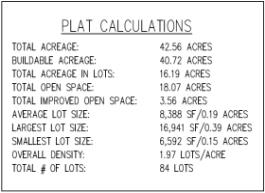
j. The names of all streets and widths and boundaries of all street and trail rights-of-way and utility easements, including bearings and distances and curve data for curving boundaries;
k. The location and a description of all monuments set during the course of the survey;
l. A signed and dated owner’s dedication in the form approved by the city which includes a complete legal description of the parcel being subdivided, and in which the owners of record dedicate all open space, public ways, utilities and other public spaces to public use;
m. A public notary’s acknowledgment of the owner’s certificate;
n. A signed and dated certificate of consent in which all mortgagors, lienholders, and other parties with any real property interest, including the holders of mineral rights, in the property consent to its subdivision;
o. A public notary’s acknowledgment of the certificate of consent;
p. Signature blocks for approval by the city council, city engineer and city attorney;
q. An owner’s dedication certificate, notary public acknowledgement for each signature on the plat, a correct metes and bounds description of all property included within the subdivision, other affidavits, certificates, acknowledgements, endorsements and notarial seals as required by law, this title or by the city recorder or city attorney;
r. A certificate for use by the county recorder in recording the plat after its approval;
s. Building envelopes for each lot shall be shown on the final plat;
t. Water rights conforming to the city’s requirements or a public water supply agreement shall be submitted to the city attorney for approval.
2. Construction Plans. Construction drawings for required public improvements will include the following and are required to be submitted with all final plat applications:
a. Plan, profile and construction detail drawings prepared by a licensed professional engineer, with his/her signature and seal.
b. Control data shall be referenced to information contained on county area reference plats.
c. Elevations shall be tied to an existing Utah County benchmark. Drawings shall show an elevation benchmark for the project.
d. The drawing scale shall be one inch equals 20 feet horizontal and one inch equals two feet vertical. The vertical scale may be smaller if warranted by unusual circumstances.
e. Stationing shall increase from left to right.
f. Centerline data and property line data shall be shown, including details of all curves.
g. Existing ground profiles shall be shown a minimum of 300 feet each way from the ends of subdivision streets.
h. All existing and proposed improvements within the project or within 100 feet of the project or adjoining the subdivision shall be shown. This includes curb, gutter, sidewalk and underground pipes and utilities, ditches, canals, fire hydrants, street lights, water valves, etc.
i. All proposed structures such as manholes, catch basins, clean-outs, etc., shall be shown. If city standard structure details exist, they may be referenced in lieu of detail.
j. All proposed drainage facilities, including pipe and boxes, shall be shown. This includes plan and profile of the system showing the method of drainage water disposal.
k. All vertical curves and horizontal distances shall be constructed in accordance with AASHTO requirements and standards.
l. Elevations shall be shown on all horizontal and vertical curves at approximately 25-foot intervals and at the points of curvature and points of tangency.
m. The minimum grade for curb and gutter shall be one-half percent identified on all curb returns and cross gutters. Percent of grade shall also be shown on straight grades with elevations at approximately 50-foot intervals with flow arrows to indicate the direction of drainage.
n. All street names shall be shown.
o. Show typical roadway cross-sections.
p. The existing grade elevations shall be shown in the profile.
q. Construction standards and specifications shall be referenced.
r. Road signs and stop signs shall be shown.
3. Landscaping and Irrigation Plan. A landscaping plan, prepared and stamped by a licensed landscape architect, indicating the location, spacing, types and sizes of landscaping elements, sprinkler system plans, existing trees if any, and showing compliance with the landscaping or buffering requirements of the appropriate zoning district. The landscaping plan shall include, at a minimum, the following information:
a. The location and dimension of all existing and proposed structures, property lines, easements, parking lots, power lines, rights-of-way, amenities, and lighting.
b. The plant names (both botanical and common name), location, quantity, and size of all existing and proposed plants. The proposed plan should indicate the size of the plant material at maturation (see Chapter 17.60 EMMC for more landscaping standards).
c. The landscaping plan should also exhibit the existing landscaping 20 feet beyond the property lines.
d. Existing and proposed grading of the site indicating contours at two-foot intervals.
e. Plans showing the irrigation system shall also be included in the landscaping plan submittal.
f. Proposed and existing fences and identification of the fencing materials.
g. A summary of the total percentage of landscaped areas, domestic turf grasses, drought-tolerant plant species along with the estimated cost of all the improvements.
h. Make, model number(s), and picture(s) of all proposed structures (playgrounds, pavilions, benches, etc.).
4. Final Utility Plan. Utility plans showing all the utilities including but not limited to water, sewer, and storm drain. The location and size of existing and proposed utility lines and facilities in or adjacent to the proposed development shall also be shown.
5. Grading, Drainage, and Erosion Plan. A grading, drainage, and erosion plan prepared and stamped by a licensed engineer shall be submitted. The report shall contain the drainage basin map and a plan view of the overall storm water system. The grading, drainage, and erosion plan shall address the following issues: description of features and hydrological conditions; drainage basin and subbasin; drainage facility design criteria; infrastructure design criteria; grading plan; and erosion control. Specifically, the report shall contain at a minimum the following information:
a. The existing roadways, drainage ways, vegetation and hydrological conditions of a 10-year, 24-hour event and a 100-year, 24-hour event.
b. The major basin descriptions referencing all major drainage reports such as FEMA, major drainage planning reports, or flood insurance maps and the basin characteristics and planned land uses.
c. The subbasin description showing the historical drainage pattern and off-site drainage patterns both upstream and downstream of the property.
d. A general discussion of how the proposed system conforms to existing drainage patterns and off-site upstream drainage will be collected to protect development.
e. The water quality evaluation showing the water quality shall not be degraded from existing storm water quality including how solids are collected and not allowed to be discharged into downstream waters and how oils and greases are separated from storm water.
f. Maintenance plan and procedure for storm water system; thorough narrative of all charts, graphs, tables or other information included in the report describing how it affects the proposed development.
g. Infrastructure design criteria showing the piping is sized to handle the peak intensity of the 10-year storm event; all detention basins are sized to handle a 100-year storm while discharging at a maximum 10-year, 24-hour historical rate; a 10-foot traffic lane in both directions is maintained at all locations within the development; and that the roadway and infrastructure will handle a 100-year storm event without flooding homes or damaging public property.
h. Grading plan showing soil map depicting unique soil features such as collapsible soil, rock features, etc.; a grading plan showing all cut and fill areas within development including: the identification of slopes; fill and cut depths; and rock features within 10 feet of post-grade soil surface.
i. The grading plan shall also show how the grades will allow water to run off of lot areas without ponding and creating flooding problems for homes.
j. Erosion control shall: show how erosion will be controlled during construction; explain and design such that construction debris and silts will not be collected by storm water system; show and design for all cut and fill slopes will not be eroded and how these areas will be revegetated.
6. Easements. The proposed grants of easement to be imposed on any land within the development.
7. Soils Report. A soils report prepared and stamped by a licensed engineer.
8. Engineer’s Estimate. An engineer’s estimate prepared by the design engineer, including detailed estimates of park amenities and landscaping improvements.
9. Fee. The processing fee required by the current consolidated fee schedule approved by the city council. [Ord. O-20-2018 § 2 (Exh. A); Ord. O-07-2014 (Exh. A); Ord. O-13-2012 § 2 (Exh. A); Ord. O-16-2010 § 2 (Exh. A); Ord. O-23-2008 § 2 (Exh. A § 5.4); Ord. O-23-2005 § 3 (Exh. 1(2) § 5.4)].
16.25.050 Approval process.
Upon completion and approval of a preliminary plat, the developer shall file a properly completed final plat application that includes a proposed final plat and all required supporting materials and the required application fee at least 28 calendar days before the planning commission meeting at which the application is to be reviewed.
A. Final Plat Procedure(s). Upon completion and approval of a preliminary plat, the developer shall file a properly completed final plat application that includes a proposed final plat and all required supporting materials and the required application fee.
1. No later than 20 business days after the day on which an applicant submits a complete final plat application the city shall complete a review of the application. However, if an applicant fails to address a review comment in the response, the review cycle is not complete and the subsequent review cycle may not begin until all comments are addressed.
2. Review Cycles. During the review process, the city may require up to four redline review turnaround cycles. Redline corrections shall be comprehensive and redlines in subsequent review cycles shall specifically address changes in response to the applicant’s adjustment to a plan set or phasing plan that adjusts the infrastructure needed for the specific development; however, modifications or corrections necessary to protect public health and safety or to enforce state or federal law may still be added.
Exception: If an applicant makes a material change to a plan set, the municipality has the discretion to restart the review process at the first review of the final application, but only with respect to the portion of the plan set that the material change(s) substantively effect(s).
3. Final Plat Review Redline Process.
a. First Round. If an applicant does not submit/return a revised plan within 20 business days after the city requires a modification or correction, the city shall have an additional 20 business days to respond to the plans.
b. Final Round. After the applicant has responded to the final review cycle, and the applicant has complied with each modification requested in the city’s previous review cycle, the city may not require additional revisions if the applicant has not materially changed the plan, other than changes that were in response to requested modifications or corrections.
4. Applicant’s Written Narrative. In addition to revised plans, an applicant shall provide a written explanation in response to the city’s review comments, identifying and explaining the applicant’s revisions and reasons for declining to make revisions, if any. The applicant’s written explanation shall be comprehensive and specific, including citations to applicable standards and ordinances for the design and an index of requested revisions or additions for each required correction.
5. Disputes. Should a dispute arise respecting the subdivision improvement plans, the city shall assemble an appeal panel in accordance with Section 10-9a-508(5)(d), Utah Code Annotated 1953, to review and approve or deny the final revised set of plans, or, for a dispute arising from the subdivision ordinance review, advise the applicant, in writing, of the deficiency in the application and of the right to appeal the determination to a designated appeal authority.
B. Final Plat Review Authorities.
1. Planning Director’s Responsibilities. The planning director shall review the application for completeness and distribute the application materials to the development review committee (DRC) members for review, comment and recommendation. If the application materials are complete, all required fees are paid and the final plat conforms to the requirements of the applicable master development plan or master development plan agreement and is in compliance with the approved preliminary plat, the DRC shall review the proposed application at its next regularly scheduled meeting when materials may be adequately distributed.
2. City Engineer’s Responsibilities. The city engineer shall review the final plat and construction plans and decide whether or not the submittal complies with the engineering and surveying standards and criteria set forth in this title, the proposed development agreement and all other applicable state statutes and city ordinances. The city engineer shall determine if the survey description is correct and that all easements are correctly described and located on the plat. If the plat conforms to the required standards, the city engineer shall prepare an estimate of the construction costs for all proposed public improvements. The city engineer shall forward this cost estimate to the city attorney, city recorder, and planning department for inclusion in the final development and improvement collateral. If the final plat and/or construction plans do not comply, the city engineer shall return the plat to the applicant or the subdivider’s engineer with comments.
3. Development Review Committee (DRC) Responsibility. The DRC shall review the final plat to determine whether the plat conforms to the requirements of the preliminary plat, with all requested changes or conditions of approval and any requirements of the master development plan agreement. If the DRC determines that the final plat is in conformity with all requirements and the ordinances of the city, the DRC members shall sign off on the approval checklist and the planning director shall prepare a notice of decision to be sent to the applicant and filed with the city recorder. The DRC includes the department head or assigned representative from each of the following departments or groups: attorney, building, energy, engineering, fire, parks, planning, public works.
4. City Attorney’s Responsibilities. The city attorney shall review the final plat for compliance with the state statutes and any applicable city ordinances, the master development plan, and the conditions of the preliminary plat.
5. City Recorder’s Responsibilities. The city recorder, subsequent to the approval of a final plat by the DRC, shall be responsible to collect original documents and all required signatures on such documents which include, but are not limited to, the original Mylar plat, improvement collateral, current title report as defined in this chapter, submittal of required water rights (as certified by the city engineer and city attorney), submittal of any required fees including recording and inspection fees and any other applicable documents. When all documents and signatures have been collected, the applicant has executed the improvement collateral including the posting of security required, the payment of all outstanding fees for this development or any other business transaction with the city has been received, and all other outstanding conditions have been met, the city recorder shall record the final plat and any other documents that the city determines should be recorded with the subdivision. [Ord. O-38-2023 § 2 (Exh. A); Ord. O-07-2014 (Exh. A); Ord. O-16-2010 § 2 (Exh. A); Ord. O-23-2008 § 2 (Exh. A § 5.5); Ord. O-23-2005 § 3 (Exh. 1(2) § 5.5)].
16.25.060 Prior to recordation.
Prior to recordation, the applicant shall submit the following:
A. Recorded Boundary Survey. A boundary survey that is recorded with Utah County that defines the out boundary of the proposed subdivision.
B. Past Taxes. Documentation that all the taxes for the subject parcel have been paid to the Utah County tax commission.
C. Title Report Required. A current title report to be reviewed by the city attorney. A “current title report” is considered to be one which correctly discloses all recorded matters of title regarding the property and which is prepared and dated not more than 30 days before the proposed recordation of the final plat.
D. If the plat has not been recorded within 180 days of its approval, a staff review is required and a fee charged (according to the consolidated fee schedule) to assure that the cost estimates and construction standards are current. [Ord. O-07-2014 (Exh. A); Ord. O-16-2010 § 2 (Exh. A); Ord. O-23-2008 § 2 (Exh. A § 5.6); Ord. O-23-2005 § 3 (Exh. 1(2) § 5.6)].
16.25.070 Security for public improvements.
Prior to recordation by the city recorder of any final plat, the applicant shall either (A) install all required improvements from the construction documents before the final plat is recorded; or (B) comply with the security provisions of this title which require full approved collateral or approved surety in the form of a corporate bond approved by the city attorney to assure completion of all improvements before building permits are issued by the city. Under option (B) above, the developer shall be required to enter into an improvement collateral agreement. This agreement shall be in a form approved by the city council and may contain specific provisions approved by the city attorney and shall include, but not be limited to, provisions that address timing and phasing of construction, time allowed for the completion of required improvements, expiration date, amount of funds to be used, a method and schedule for the release of funds, city access to funds, warranty amounts and period of warranty, maintenance of improvements during bonding and warranty periods and final acceptance of improvements. Improvement collateral requirements shall be recalculated if the subdivision was approved more than 180 days prior to the date of proposed recordation. [Ord. O-07-2014 (Exh. A); Ord. O-16-2010 § 2 (Exh. A); Ord. O-23-2008 § 2 (Exh. A § 5.7); Ord. O-23-2005 § 3 (Exh. 1(2) § 5.7)].
16.25.080 Changing an approved final plat.
Minor modifications to an approved final plat may be administratively approved at the discretion of the planning director. Major changes require an amendment to the preliminary plat (see Chapter 16.20 EMMC for the preliminary plat approval process). Major changes include an increase of lots/units, reduction of improved open space, changes to the general street layout, or any major changes to these elements of the plat. [Ord. O-07-2014 (Exh. A); Ord. O-16-2010 § 2 (Exh. A); Ord. O-23-2008 § 2 (Exh. A § 5.8)].
16.25.090 Vacating or changing a recorded subdivision plat.
Proposals to vacate or change a recorded subdivision plat shall follow the process outlined in Chapter 16.55 EMMC. [Ord. O-07-2014 (Exh. A); Ord. O-16-2010 § 2 (Exh. A); Ord. O-23-2008 § 2 (Exh. A § 5.9); Ord. O-23-2005 § 3 (Exh. 1(2) § 5.8). Formerly 16.25.080].
16.25.100 Expirations and extensions of approvals.
Final plat approvals shall expire one year from the date of approval by the city council if the plat has not been recorded at the county.
A. Extensions of Time. An extension of time may be requested by an applicant with the following requirements:
1. A written, signed request for an extension of time shall be received by the planning director prior to the expiration date of the project.
2. The request for an extension of time shall specify any progress made on the project’s condi-
tions of approval and the reasons for the extension request, along with supporting documentation.
B. Criteria for Approving Extensions of Time. It is the responsibility of the applicant to request an extension of time prior to a project’s expiration. The city is not responsible to remind applicants of expiration dates. The planning director shall approve or deny a request for an extension of time within a reasonable period of time after receiving the request. The planning director may grant up to a single one-year extension of time to any project that meets one of the following criteria:
1. The applicant must have shown a good faith effort to initiate the project by systematically completing predevelopment conditions.
2. The applicant’s initiation of development activities is based on an action by the city or other public agency which has not taken place or was delayed, resulting in a time delay beyond the permit holder’s control.
C. Appeals. An applicant may appeal the planning director’s decision to the planning commission within 15 days of the date of the decision. The applicant may then appeal a decision of the planning commission to the city council within 15 days of the planning commission’s decision. In no case shall the planning commission or city council approve more than a single one-year extension of time.
D. Resubmitting an Expired Project. A project that has expired may be resubmitted within two years of the expiration date for a fee to cover time and materials, not to exceed 50 percent of the original fee, if the project is substantially similar to the expired plan. The resubmitted project must be in compliance with the current development code at the time of resubmittal. [Ord. O-07-2014 (Exh. A); Ord. O-16-2010 § 2 (Exh. A)].