


Chapter 12.116
TRANSPORTATION STANDARDS
Sections:
12.116.030 Transportation facilities—Standard specifications adopted.
12.116.040 Transportation facilities—Design criteria.
12.116.050 Transportation facilities—Construction plans.
12.116.060 Transportation facilities—General specifications.
12.116.080 Transportation facilities—Traffic calming measures.
12.116.090 Transportation facilities—Construction bonds.
12.116.100 Transportation facilities—Record drawing plans.
12.116.110 Transportation facilities—Inspections.
12.116.120 Transportation facilities—Acceptance by the city.
12.116.130 Transportation facilities—Private streets—General specifications.
12.116.140 Private streets—Design and construction standards.
12.116.145 Private streets—Pedestrian-oriented streets.
12.116.150 Private streets—Maintenance.
12.116.160 Developments—Generally.
12.116.170 Developments—Right-of-way.
12.116.175 Developments—Traffic impact study.
12.116.180 Developments—Frontage improvements.
12.116.190 Developments—Access streets—Drainage.
12.116.200 Developments—Cross streets.
12.116.205 Developments—Cul-de-sacs—Hammer-heads—Dead ends.
12.116.210 Intersection design.
12.116.215 Intersection alignment.
12.116.240 Developments—Off-site and extra-capacity improvements.
12.116.243 Residential driveways.
12.116.246 Nonresidential driveways.
12.116.250 Arterials—Residential street intersections.
12.116.260 Major collectors and arterials—Access policy.
12.116.270 Developments—State access roads.
12.116.295 Conflicting road standards.
12.116.300 Construction details.
12.116.010 Purpose.
A. It is the purpose of this chapter to establish minimum standards for transportation facilities. Transportation facilities include public and private streets, transit facilities (e.g., bus pullouts and shelters), sidewalks, accessways, trails, bicycle lanes, street lighting, planter strips and other landscape features (e.g., islands, medians and parkways) developed as part of the streetscape. This chapter applies to all transportation facilities hereinafter constructed or improved by another as a condition of city approval of a development or by the city.
B. The intent of this chapter is to promote traffic calming in residential neighborhoods; to promote greater on-street parking opportunities; to promote more efficient use of impervious surfaces to improve overall water quality; to minimize driveway curb cuts for greater public safety; to encourage a driving-optional community; to improve safety for vehicles, pedestrians and bicyclists; to create a pedestrian-friendly community; to build upon and enhance the aesthetic look and character of the community; to improve water quality in the community through effective use of landscaping within the public right-of-way; to reduce vehicle miles traveled (VMTs); and to encourage greater inner community connectivity. (Ord. 18-06 § 2 (part), 2018: Ord. 17-04 § 2 (part), 2017: Ord. 04-021 § 7 (part), 2004: Ord. 00-021 § 3, 2000; Ord. 99-004 § 1 (part), 1999: Ord. 95-769 § 1 (part), 1995)
12.116.020 Definitions.
“Accessway” means a pedestrian and/or bicycle pathway which connects to two public streets. Accessways may pass through building side or rear yards, a building complex or between lots, but not adjacent to or within the right-of-way of a public street (i.e., the latter is a “sidewalk”). Typically accessways are contained within a separate right-of-way or easement.
“Alley” means a street providing vehicular access within a block. An alley may be a through street (e.g., connecting two streets), or terminate within the block (e.g., in a parking court). Access must be provided within the right-of-way.
“Average daily trips (ADT)” means the average number of trips on the city’s transportation system, including automobile, bicycle, walking and transit trips.
“Bicycle lane” means a lane within the street right-of-way dedicated to bicycle use. Bicycle lanes may be demarked by painted striping and/or medians.
“City engineer” means the city engineer or his/her designee.
“Controlled” means that no access is allowed unless it is the only possible option and access can be limited to right-in/right-out.
“Corner lot” is a lot at the junction of and fronting on two or more intersecting public or private streets.
“County road” means a road maintained for public travel by Clark County.
“Cul-de-sac” means a dead-end street of limited length having a primary function of serving adjoining land and constructed with a turnaround at its end.
“Development” means any subdivision, short subdivision, rezone, construction requiring a building permit, conditional use permit or other project requiring a land use permit or approval from Clark County or the city; provided, the development shall not include construction of a Group R Division 3 or Group M occupancy as defined in the 1991 Uniform Building Code.
“Development review authority” means the person charged with making a decision on a development permit as defined in Chapter 17.200 BGMC.
“Easement” means an interest in land owned by another that entitles its holder to a specific limited use or enjoyment.
“Fire code” means the currently adopted fire code listed in BGMC 15.104.011.
“Grading permit” means the permit required by the currently adopted building code listed in BGMC 15.104.010.
“Half-width street” means any public or private street right-of-way or easement which is less than the full required width specified in this chapter and which is established so that the additional half-width right-of-way or easement may be provided at a later date to complete a full-width roadway.
“Hammer-head street” means a dead-end street which terminates in a “T” configuration.
“Highway” means a street whose primary function is to provide through movement. For the purposes of this code, highways are generally limited to the city’s arterial streets.
“Local street” means a street, the primary function of which is to provide direct access to adjoining properties and which serves a limited area, usually a neighborhood.
“Loop” means a street of limited length forming a loop, having a beginning and ending on the same street, having no other intersecting street, and having as its primary function the provision of direct access to adjoining properties.
“Major collector” means a public street, the function of which is to collect traffic from neighborhoods and local streets and which connects to another public street of equal or greater classification. A major collector also may provide direct access to adjacent properties.
“Minor (secondary) arterial” means a public street connecting two or more roads of equal or greater classification, or connecting two or more communities. A secondary arterial may serve as an alternate route to a higher classified road or a traffic generation of medium importance (e.g., a commercial area) and serves an additional function of land service.
“MUTCD” means the Manual of Uniform Traffic Control Devices for streets and highways as adopted by the Washington State Department of Transportation, current edition.
“Neighborhood collector” means a street, the primary function of which is to provide direct access to adjoining properties but which also provides for traffic circulation within and through a neighborhood.
“Parkway” means a linear park or open space area adjacent to a public street. Parkways typically include trails and landscaping and may be used to satisfy the city’s open space and park dedication standards when required as a condition of development approval.
“Pedestrian-oriented street” means a private street where access is only for pedestrians and emergency and maintenance vehicles.
“Planning director” means the city’s planning director or his/her designee.
“Planter strip” means a planted area between the street curb and sidewalk or between the sidewalk and adjacent property line. Planter strips typically include street trees, ground cover plantings, and street lighting. They may be interrupted by transit facilities (e.g., bus pullouts, shelters and benches), postal service delivery and drop boxes, and similar facilities as approved by the planning director.
“Principal (major) arterial” means a street connecting two or more towns or communities, connecting two highways of equal or greater capacity, or serving as the primary access to a large land area. A major arterial may also serve a large traffic generator (e.g., an industrial area) and perform a secondary function of providing local access.
“Private street” means a street not maintained by the city, the county, or the Washington State Department of Transportation.
“Protected natural area” means unique and natural habitats for a broad biological diversity of fauna and flora, where human encroachment is restricted in order to preserve biodiversity for present and future generations.
“Public street” means a street maintained by the city, the county, or the Washington State Department of Transportation.
“Roadside” means the portion of an easement or right-of-way lying on either side of the roadway, including curbs, sidewalks and ditches.
“Roadway” means the improved portion of an easement or right-of-way, excluding curbs, sidewalks, and ditches.
“Sidewalk” means a pedestrian access adjacent to or within the right-of-way of a public road.
“Spacing” means the distance between two points as measured from centerline to centerline except for BGMC 12.116.220, Sight distances, and where otherwise noted in this chapter.
“Special provisions” means road construction requirements peculiar to a specific project and which are not otherwise thoroughly or satisfactorily detailed and set forth in the standard specifications.
“Standard specifications” means those specifications adopted for street construction by the city engineer.
“Structure” means that which is built or constructed, an edifice or building of any kind, or any piece of work, artificially built up or composed of parts jointed together in some definite manner, but does not include utility poles for the purposes of this chapter.
“Traffic calming” means any design technique approved by the city engineer to slow traffic, including but not limited to: neighborhood entries (e.g., landscaped medians and islands); curvilinear streets; and design details (e.g., curb extensions, roundabouts, humps, chicanes, etc.). For specific traffic calming definitions, please refer to BGMC 12.116.080.
“Trail” means a meandering or separated pathway designed for pedestrians, or pedestrians and bicyclists. Typically a trail is developed within a linear park or “parkway.” Trails may be contained within the street right-of-way or a separate right-of-way or easement.
“Transit facility” means any street improvement which supports transit service (e.g., bus pullout, waiting area, shelter, kiosk). The design and location of transit facilities are subject to city standards as well as C-TRAN requirements. (Ord. 18-06 § 2 (part), 2018: Ord. 17-04 § 2 (part), 2017: Ord. 14-07 § 6 (part), 2014: Ord. 04-021 § 7 (part), 2004: Ord. 01-003 § 1 (part), 2001; Ord. 99-004 § 1 (part), 1999: Ord. 95-769 § 1 (part), 1995)
12.116.030 Transportation facilities—Standard specifications adopted.
A. The standards for city streets and bridges and all other construction within publicly owned rights-of-way shall consist of the current editions of the following: the “Standard Specifications for Road and Bridge Construction” as published by the Washington State Department of Transportation, jointly with the Washington State Chapter of the American Public Works Association and all subsequent revisions thereto, the “Washington State Department of Transportation Design Manual” and all subsequent revisions thereto, the American Association of State Highway and Transportation Officials’ “A Policy on Geometric Design of Highways and Streets” and all subsequent revisions thereto, the “Manual on Uniform Traffic Control Devices (MUTCD)” prepared by the U.S. Department of Transportation, Federal Highway Administration and all subsequent revisions thereto, the “Trip Generation Manual” prepared by the Institute of Transportation Engineers (ITE) and all subsequent revisions thereto, the design criteria set forth in BGMC 12.116.040, and the construction details provided in BGMC 12.116.300. Standard specifications for private streets shall be determined in conformance with BGMC 12.116.130 through 12.116.145.
B. The city engineer shall specify which of the standard specifications will apply to each construction project.
C. Copies of the standard specifications for utility improvement are available at the office of the city engineer or City Hall for review.
D. When the design criteria set forth in BGMC 12.116.040 conflict with the above-referenced Washington State Department of Transportation (WSDOT) design standards, BGMC 12.116.040 shall prevail, except as may be required for WSDOT facilities. (Ord. 18-06 § 2 (part), 2018: Ord. 17-04 § 2 (part), 2017: Ord. 04-021 § 7 (part), 2004: Ord. 01-003 § 1 (part), 2001; Ord. 99-004 § 1 (part), 1999: Ord. 95-769 § 1 (part), 1995)
12.116.040 Transportation facilities—Design criteria.
A. The following design criteria (see Tables 12.116.040(A) through (D) and Figures 12.116.040(A) through (D)) are adopted as a portion of the city’s standard specifications. All streets shall be designed to a minimum twenty-year life unless otherwise specified by the city engineer. When upgrading facilities, all utility poles and other conflicting structures shall be relocated outside the sidewalk limits and undergrounded except when allowed under the modification process of BGMC 12.116.290.
B. Except where needed for public circulation, streets within mobile home parks and multifamily developments may be private and can serve more than eight units when allowed under the modification process of BGMC 12.116.290. Required or proposed city streets shall be built to those standards adopted by reference in this chapter. Private roads shall additionally be built in accordance with the conditions of BGMC 12.116.130 and 12.116.145. Right-of-way and roadway widths may be reduced pursuant to the modification procedure contained in BGMC 12.116.290.
|
Table 12.116.040A Arterial Streets |
||
|---|---|---|
|
|
.1 Principal Arterial |
.2 Minor Arterial |
|
Function |
Intercommunity highway serving as primary access to a large land area |
Highway connecting two or more streets of equal or greater classification and serves as an additional function of land service |
|
Access |
Controlled |
Controlled |
|
Maximum Arterial Spacing |
2 to 5 miles |
Under 2 miles |
|
Average Daily Trips Daily Hourly Volume |
10,000+ over 600 |
8,000+ 200—600 |
|
Right-of-Way |
100 feet (4 travel lanes; 1 center turn lane or median) |
70 feet (3 travel lanes; or 2 travel lanes and center turn lane/median) |
|
Pavement |
70 feet +/- curb to curb |
46 feet +/- curb to curb |
|
Lane Width |
11—12 feet |
12 feet |
|
Bicycle Lane |
6 feet, striped, in both directions |
5 feet, striped, in both directions |
|
Parking/Shoulder |
No parking on shoulder, except in approved bays |
No parking on shoulder, except in approved bays |
|
Median/Turn Lane |
14 feet, 12-foot median (face of curb to face of curb) |
12 feet, 10-foot median (face of curb to face of curb) |
|
Street Lighting |
Required |
|
|
Planter Strip and Sidewalks2 |
8-foot-wide planter strip and 6-foot-wide detached sidewalk required on both sides of the street |
6-foot-wide planter strip and 6-foot-wide detached sidewalk required on both sides of the street |
|
Transit Facilities |
As recommended by transit agency and approved by city engineer |
|
|
Minimum Full-Access Intersection Spacing1 |
600 feet |
500 feet |
|
1. Intersection with public or private streets serving a potential of eight or fewer single-family residential lots shall be subject to the driveway spacing requirements. 2. In all commercial zones, the entire planter strip and sidewalk width are required to be sidewalk. Tree wells shall be provided every thirty feet, replacing the planter strip. |
||
|
Table 12.116.040A Arterial Streets |
|
|---|---|
|
|
.3 Modified Minor Arterial1 |
|
Function |
Highway connecting two or more streets of equal or greater classification and serves as an additional function of land service |
|
Access |
Controlled |
|
Maximum Arterial Spacing |
Under 2 miles |
|
Average Daily Trips Daily Hourly Volume |
8,000+ 200—600 |
|
Right-of-Way |
60 feet (2 travel lanes and center turn lane/median) |
|
Pavement |
44 feet +/- curb to curb |
|
Lane Width |
11 feet |
|
Bicycle Lane |
5 feet, striped, in both directions |
|
Parking/Shoulder |
No parking on shoulder, except in approved bays |
|
Median/Turn Lane |
12 feet |
|
Street Lighting |
Required |
|
Planter Strip and Sidewalks |
3-foot-wide planter strip and 5-foot-wide detached sidewalk required on both sides of the street |
|
Transit Facilities |
As recommended by transit agency and approved by city engineer |
|
Minimum Full-Access Intersection Spacing2 |
500 feet |
|
1. This cross-section may only be used on existing roads and when approved by the city engineer. 2. Intersection with public or private streets serving a potential of eight or fewer single-family residential lots shall be subject to the driveway spacing requirements. |
|
Figure 12.116.040A.1
Arterial Streets Section Drawings
Principal Arterial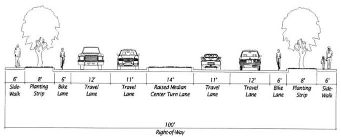
Figure 12.116.040A.2
Arterial Streets Section Drawings
Minor Arterial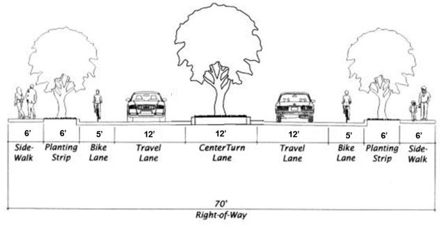
Figure 12.116.040A.3
Modified Minor Arterial Street Section Drawings
Modified Minor Arterial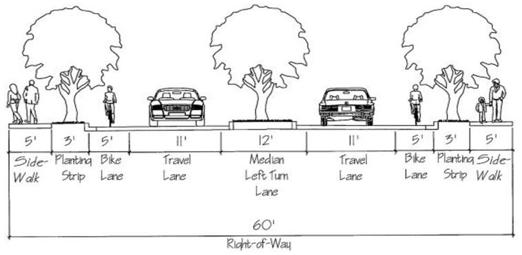
|
Table 12.116.040B Collector Streets |
||
|---|---|---|
|
|
.1 Major Collector—Option 1 |
.2 Major Collector—Option 2 |
|
Function |
Street collecting traffic from neighborhoods or commercial/industrial districts; connects to another public street of equal or greater classification |
|
|
Access |
Controlled |
|
|
Average Daily Trips (approximate) |
5,000+ |
|
|
Right-of-Way |
64 feet |
60 feet |
|
Pavement |
46 feet curb to curb except as reduced for medians |
44 feet curb to curb except as reduced for medians |
|
Lane Width |
12 feet |
11 feet |
|
Bicycle Lane |
5 feet, striped, in both directions |
|
|
Parking/Shoulder |
None |
|
|
Median/Turn Lane |
12 feet (landscaped median typical, except where turn lane required), 10-foot median (face of curb to face of curb) |
|
|
Street Lighting |
Required |
|
|
Planter Strip and Sidewalk2 |
4-foot-wide planter strip and 5-foot-wide sidewalk required on both sides of street |
3-foot-wide planter strip and 5-foot-wide sidewalk required on both sides of street |
|
Transit Facilities |
As recommended by transit agency and approved by city engineer |
|
|
Intersection Spacing3 |
250 feet minimum 500 feet maximum |
|
|
1. Option 1 is the standard for Battle Ground. It will be used in all cases except where Option 2 or 3 is approved by the city engineer. Option 2 may be approved where it is not feasible to provide additional right-of-way to construct Option 1. Option 3 may be approved when a majority of the rest of the road segment has been previously built to this standard. 2. In all commercial zones, the entire planter strip and sidewalk are required to be sidewalk. Tree wells shall be provided every thirty feet, replacing the planter strip. 3. Intersection spacing on major collectors shall be as close to five hundred feet as is practical. Cul-de-sacs and the like, as allowed by Table 12.116.040E, shall be used when necessary to achieve this. The city engineer shall approve any intersection to a major collector. |
||
|
Table 12.116.040B Collector Streets |
||
|---|---|---|
|
|
.3 Major Collector—Option 3 |
.4 Neighborhood Collector |
|
Function |
Street collecting traffic from neighborhoods or commercial/industrial districts; connects to another public street of equal or greater classification |
Street connecting two or more neighborhoods with access to adjoining properties. The neighborhood collector is the typical street for multifamily and commercial developments when an arterial street is not required |
|
Access |
Controlled |
Access limited to abutting lots not fronting on local streets or alleys |
|
Average Daily Trips (approximate) |
5,000+ |
Under 2,000 (except in commercial areas) |
|
Right-of-Way |
60 feet |
50 feet |
|
Pavement |
40 feet curb to curb except as reduced for medians |
32 feet curb to curb except as reduced for neighborhood entries |
|
Lane Width |
14 feet, shared with bicycles |
16 feet total |
|
Bicycle Lane |
Bicycles share the travel lanes |
4 feet, striped, in both directions, except when on-street parking is required, bicycles share street |
|
Parking/Shoulder |
None |
8-foot-wide parking shoulder on one or both sides, except when separate bicycle lanes required (see above) |
|
Median/Turn Lane |
12 feet (landscaped median typical, except where turn lane required), 10-foot median (face of curb to face of curb) |
None, except when landscape entryway provided (BGMC 12.116.080)
|
|
Street Lighting |
Required |
Decorative lighting required |
|
Planter Strip and Sidewalk2 |
5-foot-wide planter strip and 5-foot-wide sidewalk required on both sides of street |
4-foot-wide planter strip and 5-foot-wide sidewalk required on both sides of street |
|
Transit Facilities |
As recommended by transit agency and approved by city engineer |
|
|
Intersection Spacing3 |
250 feet minimum 500 feet maximum |
|
|
1. Option 1 is the standard for Battle Ground. It will be used in all cases except where Option 2 or 3 is approved by the city engineer. Option 2 may be approved where it is not feasible to provide additional right-of-way to construct Option 1. Option 3 may be approved when a majority of the rest of the road segment has been previously built to this standard. 2. In all commercial zones, the entire planter strip and sidewalk are required to be sidewalk. Tree wells shall be provided every thirty feet, replacing the planter strip. 3. Intersection spacing on major collectors shall be as close to five hundred feet as is practical. Cul-de-sacs and the like, as allowed by Table 12.116.040E, shall be used when necessary to achieve this. The city engineer shall approve any intersection to a major collector. |
||
Figure 12.116.040B.1
Collector Streets Section Drawings
Major Collector—Option 1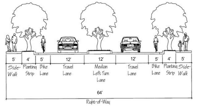
Figure 12.116.040B.2
Collector Streets Section Drawings
Major Collector—Option 2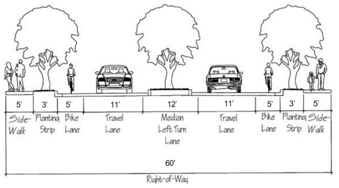
Figure 12.116.040B.3
Collector Streets Section Drawings
Major Collector—Option 3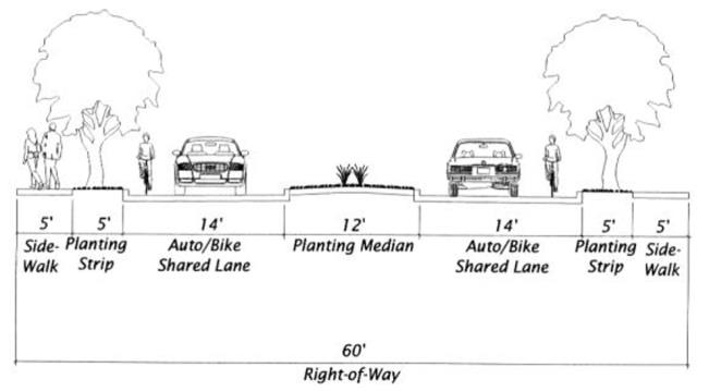
Figure 12.116.040B.4
Collector Streets Section Drawings
Neighborhood Collector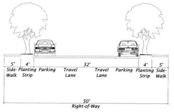
|
Table 12.116.040C Local Streets |
||
|---|---|---|
|
|
.1 Local Street “A”1 |
.2 Local Street “B”1 |
|
Function |
Neighborhood street providing direct access to residential lots. May also provide access to alleys. Local Street “A” is an optional street standard for small multifamily residential developments |
Neighborhood street with limited access to adjoining lots (access shall be provided from alleys, via cross streets) |
|
Access |
Full access to adjoining lots |
Limited direct access to adjoining lots |
|
Average Daily Trips (approximate) |
Under 1,000 |
Under 500 |
|
Right-of-Way |
48 feet |
40 feet |
|
Pavement |
30 feet curb to curb |
22 feet curb to curb |
|
Lane Width |
14 feet total |
14 feet total |
|
Bicycle Lane |
Bicycles share roadway |
Bicycles share roadway |
|
Parking/Shoulder |
8 feet on both sides of the street |
8 feet on one side |
|
Street Lighting |
Decorative lighting required |
|
|
Planter Strip and Sidewalk2 |
4-foot-wide planter strip and 5-foot-wide detached sidewalk required on both sides of the street |
4-foot-wide planter strip and 5-foot-wide detached sidewalk required on both sides of the street |
|
Minimum and Maximum Intersection Spacing |
240 feet minimum distance between “A” streets and other streets, except as provided in Tables 500 feet maximum intersection spacing, except as provided by BGMC 12.116.070, Pedestrian circulation; 12.116.200, Cross streets; and 12.116.290, Modifications |
240 feet minimum distance between “B” streets and other streets, except as provided in Tables 500 feet maximum intersection spacing, except as provided by BGMC 12.116.070, Pedestrian circulation; 12.116.200, Cross streets; and 12.116.290, Modifications |
|
Cul-de-Sacs and Hammer-Head Streets |
Cul-de-sac and hammer-head streets are not allowed, except when necessary for access management or protection of parks and natural resources. When approved under BGMC 12.116.290, Modifications, cul-de-sac shall provide a 45-foot turnaround radius and comply with BGMC 12.116.070, Pedestrian circulation |
Cul-de-sac and hammer-head streets are not allowed, except when necessary for access management or protection of parks and natural resources. When approved under BGMC 12.116.290, Modifications, cul-de-sac shall provide a 45-foot turnaround radius and comply with BGMC 12.116.070, Pedestrian circulation |
|
1. Table 12.116.040E provides a key for determining required street standards for various scenarios. Additional right-of-way may be required when parkways or parking bays are incorporated into the streetscape, or when slopes/physical conditions require additional right-of-way. Right-of-way requirements shall be determined through the subdivision and site design review permit process. 2. In all commercial zones, the entire planter strip and sidewalk width is required to be sidewalk. Tree wells shall be provided every thirty feet, replacing the planter strip. |
||
Figure 12.116.040C.1
Local Streets Section Drawings
Local Street—Option “A”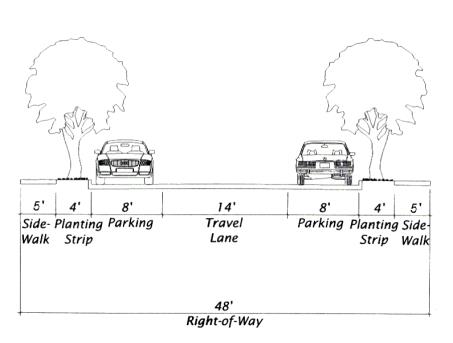
Figure 12.116.040C.2
Local Streets Section Drawings
Local Street—Option “B”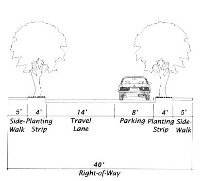
|
Table 12.116.040D Alleys |
||
|---|---|---|
|
|
.1 One-Way Alley1, 2 |
.2 Two-Way Alley1, 2 |
|
Function and Limitations |
Alleys provide direct access to adjoining lots. They reduce the number of required curb cuts along public streets and improve the appearance and human scale of streetscapes (i.e., by reducing the amount of parking and parking garages oriented to the street). Short alleys are appropriate in low-density residential zones with minimal traffic generation and relatively short blocks (i.e., under 200 feet). Short alleys may function as through-travel lanes or parking courts (e.g., hammer-head terminus). When used as parking courts, alleys may not exceed 150 feet in length |
Long alleys are appropriate for low-density residential development on longer blocks (i.e., 400—500 feet), and medium- and high-density residential development when parking bays are provided. They may also provide access to commercial development. Long alleys may function as through-travel lanes or parking courts (e.g., hammer-head terminus). When used as parking courts for more than four vehicles, alleys may not exceed 150 feet in length (i.e., from street access to parking bay)
|
|
Access |
Full access to adjoining lots; provided, that all lots having alley access front on a public or private street as designated by this title; and provided, that alleys are a permanent secondary, not primary, means of access to the lot, unless otherwise authorized by the city engineer or hearing examiner |
Full access to adjoining lots; provided, that all lots having alley access front on a public or private street as designated by this title; and provided, that alleys are a permanent secondary, not primary, means of access to the lot, unless otherwise authorized by the city engineer or hearing examiner |
|
Average Daily Trips |
Under 150+/- |
Under 500+/- |
|
Right-of-Way or Easement |
12 feet minimum 15 feet maximum |
20 feet minimum and maximum except as wider sections may be approved as necessary for parking courts |
|
Pavement Width |
10 feet (1-foot clear zone on both sides) |
18 feet (1-foot clear zone on both sides) |
|
Building Setbacks and Clear Vision Zones |
Please refer to zoning chapters |
Please refer to zoning chapters |
|
Lighting |
Low-profile, security lighting shall be required with new development |
Low-profile, security lighting shall be required with new development |
|
Intersection Spacing:3 Alley to Local Street “A” and Local Street “B” Alley to Collector and Higher Classification Street |
Minimum 110 feet
Minimum 110 feet
|
Minimum 110 feet
Minimum 110 feet
|
|
Dead-End Alleys |
Alleys over 150 feet in length shall not end in a dead end except in the following conditions: (1) the alley dead-ends to prevent access to a controlled access street; or (2) there are unusual topographic conditions or existing construction that would prevent continuation of the alley. If an alley meets one of these conditions, then an approved turn-around, per the AASHTO Policy on Geometric Design of Highways and Streets, must be provided. |
|
|
1. Additional right-of-way or easement area may be required when parking bays are incorporated into the streetscape, or when slopes/physical conditions require additional right-of-way. Right-of-way requirements shall be determined through the subdivision and site design review permit process. 2. Alleys over five hundred feet long shall have a minimum of three entrances. 3. Measured from curb to centerline of alley. |
||
Figure 12.116.040D.1
Alley Section Drawings
One-Way Alley
Figure 12.116.040D.2
Alley Section Drawings
Two-Way Alley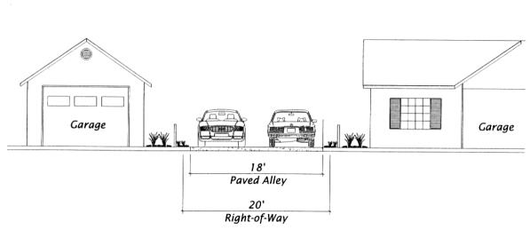
|
Table 12.116.040E Determination of Required Street Standards |
||||||
|---|---|---|---|---|---|---|
|
The following shall be used in determining which of the street standards listed in Tables 12.116.040A through 12.116.040D are required for new development. Exceptions to these standards shall be subject to review under BGMC 12.116.290. |
||||||
|
Arterial Streets |
All required arterial streets are shown on the city’s adopted 20-year transportation plan. The “minor arterial” street is the standard street section for commercial and industrial developments, except where the transportation plan requires a major arterial
|
|||||
|
Collector Streets |
1. Collector streets are required in corridors identified by the city’s transportation plan 2. The “neighborhood collector” street is the standard street section for multifamily developments, except that the “Local-A” street may be approved where multifamily zone districts adjoin single-family zone districts along local streets. This determination shall be subject to review and approval by the development review authority |
|||||
|
Residential Streets1 |
||||||
|
|
Zone A (R3, R5, and R7)2 |
Zone B (R10, R12, R16, and R20)2 |
||||
|
Frontage Types |
Zone A—Alleys Two parallel blocks receive access from alleys |
Zone A—Hybrid One block receives alley access; parallel block receives street access |
Zone A—Streets Access from streets on two parallel blocks |
Zone B/Zone B Both sides of street are zoned Zone B |
Zone A/Zone B One side of street zoned Zone A, other zoned Zone B |
Zone B/ Nonresidential One side of street zoned Zone B, other side is nonresidential zone |
|
Local Streets |
Local “B” is required |
Option for “A” or “B,” subject to review and approval by the development review authority |
Local “A” is required |
Neighborhood collector, or other, as determined by the development review authority |
Local “A” is option, subject to review and approval by the development review authority |
Major collector, or other, as determined by the development review authority |
|
Alleys |
Alleys may be used in new residential development when lots face a restricted access street (e.g., major collector or higher) or when the lots being served have street frontage of 60 feet or less. Alleys shall conform to the specifications in Table 12.116.040D. |
|||||
|
Traffic Calming |
Traffic calming is required for all residential streets. See standards in BGMC 12.116.080 |
|||||
|
Cul-de-Sac and Hammer-Head Streets |
Cul-de-sac and hammer-head streets are not allowed, except when necessary for access management or protection of parks and natural resources. When approved under BGMC 12.116.290, Modifications, cul-de-sacs shall provide a 45-foot turnaround radius and comply with BGMC 12.116.070, Pedestrian circulation. When approved under BGMC 12.116.290, Modifications, hammer-head streets shall be designed in accordance with the currently adopted fire code |
|||||
|
Dead-End Streets |
Streets that dead end and are over 150 feet in length are required to have a temporary cul-de-sac or hammer-head as described above. Streets that dead end, are over 150 feet, cannot be extended in the future, and do not meet the requirements for cul-de-sac and hammer-head streets above are not allowed. Length is measured from the closest parallel curb of the cross street to the end of the road. Removal of the temporary turnaround and extension of the sidewalk shall be responsibility of the developer who extends the road. The easement for a temporary turnaround may be extinguished without city approval after the temporary turnaround is determined to be no longer necessary |
|||||
|
1. Residential streets include streets in Zone A and Zone B, defined above. “Access” refers to access for residential streets. “Parallel blocks” refer to blocks with rows of lots/houses facing each other. 2. Zone A and Zone B designations are for clarification of this table only. |
||||||
(Ord. 22-17 § 1, 2022; Ord. 21-32 § 3, 2021; Ord. 21-07 § 2, 2021; Ord. 18-06 § 2 (part), 2018: Ord. 17-04 § 2 (part), 2017: Ord. 16-12 § 1 (part), 2016; Ord. 14-07 § 6 (part), 2014; Ord. 09-08 § 5, 2009; Ord. 06-07 § 1, 2006; Ord. 04-021 § 7 (part), 2004: Ord. 01-003 § 1 (part), 2001; Ord. 00-021 § 1 (part), 2000; Ord. 99-04 § 1 (part), 1999; Ord. 95-769 § 1 (part), 1995)
12.116.050 Transportation facilities—Construction plans.
A. The designing engineer shall submit plans and specifications for street and utility construction for the proposed development. The specifications shall include a vicinity map, a plan and profile, special provisions, and reference to the standard specifications, including the typical sections. The applicant shall also submit a landscape plan for all planting areas, including street trees, planter strips, landscaped medians, islands, entry features, and other planted areas within the public right-of-way.
B. Streets and Utilities Plan. The plan shall include the street alignment at a scale of not less than one inch to one hundred feet, showing bearings on centerline, curve data on all horizontal curves (unless shown on an accompanying plat), right-of-way lines, topography within the right-of-way, relevant topography adjacent to the right-of-way, existing and proposed utility location, street names in the development and adjoining the development, typical roadway section showing placement of utilities, existing and proposed drainage structures, and such further data as may be required by the city engineer.
C. Streets and Utilities Profile. The profile shall show the original ground lines, same stationing as in the plan, control elevations, grade line showing the grades, horizontal and vertical curves, all bench marks, the data plane and such further information as may be reasonably required by the city engineer. The ground lines for streets extending to the perimeter of any development shall be extended a sufficient distance beyond the perimeter to include any change in contours which would affect the profile of the proposed street, which extension shall in no event be less than two hundred feet. Plan and profile may be shown in the same sheet with the profile on the bottom half. Sheets shall measure twenty-two to twenty-four by thirty-four to thirty-six inches with a borderline of two and one-half inches on the left side and one-half inch on the remaining sides.
D. Streets and Utilities Plan—Special Provisions. The cover sheet of all plans shall include a statement identifying which standard specifications will apply to the project. Any special technical provisions will also be shown on the plans.
E. Streets and Utilities Plan—Format. When more than two plan sheets are used, an overall development layout shall be submitted showing the relationship of streets and utilities. Record drawing plans shall be provided in accordance with BGMC 12.116.100.
F. Landscape Plan. Landscape plans shall identify all planting areas, including street trees, planter strips, landscaped medians, islands, entry features, and other planted areas within the public right-of-way. Plans shall include a planting list (i.e., with species, quantities, size/caliper), soil specifications, planting details or specifications and irrigation plan or specifications. The landscape plan shall be subject to review and approval by the city engineer, who may impose conditions of approval to ensure that the planting complies with the city’s approved plant list (on file with the public works department). Record drawing plans shall be provided in accordance with BGMC 12.116.100.
G. Driveway Plan. Driveway plans shall identify all curb cuts and show all utilities to avoid potential conflicts. The driveway plan shall be combined with the landscape plan where possible. Record drawing plans shall be provided in accordance with BGMC 12.116.100.
H. Signing, Striping, and Street Lighting Plan. This plan shall show the locations of all signs and striping, designed in accordance with the MUTCD, and the location of all street lighting, designed in accordance with the latest Illuminating Engineering Society (IES) standards. Record drawing plans shall be provided in accordance with BGMC 12.116.100.
I. Traffic Calming. This plan shall show the location and type of all traffic calming, designed in accordance with this chapter. A preliminary plan shall be provided with subdivision application submittal. Record drawing plans shall be provided in accordance with BGMC 12.116.100. (Ord. 22-17 § 1, 2022; Ord. 18-06 § 2 (part), 2018: Ord. 17-04 § 2 (part), 2017: Ord. 16-12 § 1 (part), 2016; Ord. 14-07 § 6 (part), 2014: Ord. 04-021 § 7 (part), 2004: Ord. 99-004 § 1 (part), 1999: Ord. 95-769 § 1 (part), 1995)
12.116.060 Transportation facilities—General specifications.
A. Typical Roadway Section. The city’s standard roadway sections are not intended to eliminate the need for design of sections for streets. The city’s standard typical sections are minimums and all road improvements shall be designed and certified by or under the supervision of a registered civil engineer prior to acceptance by the city. The roadway section shall be detailed on the construction plans submitted for each new roadway or improvement to an existing roadway.
The typical section shall show the width of right-of-way, width of roadway, type and compacted depth of base material, type and depth of soil for planting beds, type and compacted depth of surfacing, type and compacted depth of paving and such other dimensions as may be necessary or required. Shown also shall be the location and width of sidewalks, bicycle lanes, accessways, trails, curbs or curb and gutter, when applicable.
B. Surfacing/Depth Determination. The depth of materials shall be shown on the typical sections for roadway construction and as stated in this chapter unless modified as follows:
1. The city engineer, after reviewing soil tests prepared by a qualified soils engineer, determines a heavier section is required; or
2. The developer provides a soil test reported to the city engineer prepared by a qualified soils engineer, indicating a lesser depth is satisfactory, and the engineer approves the lesser depth. Any modification approved by the engineer under this subsection shall be based upon the standard specifications taking into consideration anticipated traffic loading characteristics, soil types, surfacing materials and other relevant factors.
C. Construction Revisions. Changes after approval may be made only upon written request of the owner approved by the city engineer, or request by the city engineer approved by the owner. If there is a contract between the owner and a contractor, the contractor must be involved in the revision. The planning director shall be responsible for reviewing any changes to approved landscape plans, in coordination with the city engineer and contractor, if applicable.
D. Grades and Drainage Structures. Drainage details and street centerline profile grades shall be shown on the construction plans. Centerline profile street grades shall not be less than three-tenths percent. If any grading or filling to lots or other areas outside the street is to be done which exceeds those amounts specified in the currently adopted building code listed in BGMC 15.104.010, an overall grading plan shall be submitted as a part of the plans.
E. Construction. Construction shall not start prior to the construction plans having been signed by the city engineer and, as applicable, the final plat survey computations having been approved by the city engineer, and the landscape plan (i.e., for plantings within the public right-of-way) having been signed by the planning director. Rough grading operations may proceed before the plans are approved by the city engineer and planning director only under the following conditions:
1. The grading plan is submitted separately along with an application for a grading permit;
2. The grading plan is in conformance with the approved preliminary plat;
3. The grading plan will not be in substantial conflict with the street profiles and drainage structure plans;
4. The grading permit is issued; and
5. The grading plan preserves and protects all trees and other vegetation which are required to be protected in accordance with the approved preliminary plat or site plan approval. (Ord. 18-06 § 2 (part), 2018: Ord. 17-04 § 2 (part), 2017: Ord. 04-021 § 7 (part), 2004: Ord. 99-004 § 1 (part), 1999: Ord. 95-769 § 1 (part), 1995)
12.116.070 Transportation facilities—Pedestrian and bicycle circulation—Sidewalks, accessways, trails, pedestrian paths, and bicycle lanes.
A. Sidewalk Requirement. Sidewalks shall be constructed adjacent to and/or within a parcel being developed as provided for below:
1. Within the city’s urban service area and within the city limits:
a. Sidewalks shall be constructed:
i. Along the frontage of all public and private streets in the urban service area in accordance with the street design standards in BGMC 12.116.040;
ii. Along both sides of roads, including private streets, serving residential multifamily, commercial or industrial developments;
b. Sidewalks, when required in accordance with this section, shall be constructed along the frontage of all public and private streets adjacent to a parcel located within the urban area whenever any one of the following occurs:
i. A project subject to site plan review is hereinafter constructed on the parcel; or
ii. The parcel is hereinafter granted plat or short plat preliminary approval.
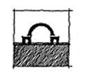
B. Accessway Requirement. An accessway shall be provided between streets when the length of the block between the two subject streets exceeds five hundred feet, to provide direct and convenient pedestrian circulation. The developer may be required to install stairways and/or retaining walls to complete an accessway. Accessways shall be required to connect cul-de-sacs with adjacent streets when (1) cul-de-sacs are approved in accordance with BGMC 12.116.290, Modifications, (2) the adjacent street is located within two hundred fifty feet of the cul-de-sac, and (3) unobstructed right-of-way or easement(s) can reasonably be dedicated for the accessway. The required section for accessways is provided in Figure 12.116.070.
C. Trails. Where called for in the city of Battle Ground’s parks, recreational and open space plan trails shall be constructed as provided below:
1. Abutting the Right-of-Way.
a. Trail shall be constructed of concrete;
b. Trail shall be a total of twelve feet wide including the portion of standard sidewalk required by BGMC 12.116.040; and
c. A trail easement shall be dedicated to the city by the developer, for the remaining width, minus the standard sidewalk, that is required to equal twelve feet.
2. Not Abutting the Right-of-Way.
a. Trail shall be constructed of asphalt;
b. Trail shall be a total of twelve feet wide; and
c. A trail easement fifteen feet in width shall be dedicated to the city by the developer.
D. Pedestrian Paths. Pedestrian paths are those paths installed in parks, wetlands, or tracts that would not meet the trail definition of subsection C of this section.
1. The width shall be per Figure 12.116.070 unless modified per BGMC 12.116.290.
2. The path is subject to review and approval by the city engineer and planning director. Paths must be developed with asphalt or concrete that complies with the Americans with Disabilities Act (ADA). Alternative materials may be approved by the city engineer; provided, that the material meets all ADA requirements and can be shown to be no more difficult to maintain than asphalt or concrete.
E. Bicycle Lane Standard. Bicycle lanes shall be designed in accordance with BGMC 12.116.040.
F. Sidewalk Construction Standards. Materials and construction for sidewalks adjacent to city streets shall conform to the standard specifications found in BGMC 12.104.010 and the Americans with Disabilities Act.
G. Construction. Unless earlier installation is required by the city engineer, required sidewalks, trails, accessways and bicycle lanes shall be installed in conjunction with either the construction of an adjacent public street or the construction of a building structure. That portion of any required sidewalks adjacent to any lot shall be constructed prior to issuance of a certificate of occupancy for a building constructed on such lot, unless a mitigation agreement and/or bond is requested by the city engineer and implemented by the developer. Utility poles and other conflicting structures shall be relocated outside the sidewalk limits.
H. Construction Bond. If the city engineer determines that construction is not feasible when a building is ready for occupancy, a construction bond or other security acceptable to the city engineer shall be posted guaranteeing the construction of required sidewalks, accessways, trails, pedestrian paths, and bicycle lanes. The amount of such construction bond, or other security, shall be set by the city engineer based upon the estimated cost of installation at the time when the improvement is to be constructed.
I. Procedure. Except as modified in this chapter, the reviews, approval, inspection and acceptance procedures established elsewhere in this chapter shall similarly apply to sidewalks.
Figure 12.116.070
Typical Section for Paths and Accessways
Pedestrian-Bike Pathway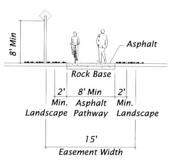
(Ord. 22-17 § 1, 2022; Ord. 18-06 § 2 (part), 2018: Ord. 17-04 § 2 (part), 2017: Ord. 15-04 § 12, 2015: Ord. 04-021 § 7 (part), 2004: Ord. 99-004 § 1 (part), 1999: Ord. 95-769 § 1 (part), 1995)
12.116.080 Transportation facilities—Traffic calming measures.
Traffic calming improves neighborhood livability and the pedestrian environment by reducing vehicle speeds, vehicle noise, visual impacts and through traffic volumes. Traffic calming includes a variety of design techniques and traffic management programs. The following traffic calming standards apply to new development:
A. Preliminary plats and multifamily site plans shall provide traffic calming as an integral part of the design.
B. Traffic calming measures are required for all residential streets. Residential streets include public and private streets developed within or adjacent to a residential zone district. Every proposed residential street shall include at least one of the “developer options” for traffic calming, as shown in Figure 12.116.080A.
C. Traffic calming measures shall be subject to review and approval through the subdivision or site plan review process, as applicable.
D. Street construction plans submitted under BGMC 12.116.050 shall incorporate traffic calming measures as required by preliminary plat and site plan approvals.
|
Figure 12.116.080A Traffic Calming Measures—City and Developer Options |
||
|---|---|---|
|
The city of Battle Ground and private developers have the option of implementing the following traffic calming methods. Methods which do not place an obstruction in the roadway are encouraged, such as narrow streets, curb bulbouts, special paving or chicanes. |
||
|
Drawings* |
Technique |
Description |
|
|
Neighborhood Entry |
Travel lanes separated by a landscaped median and lined with street trees can provide an attractive traffic calming transition between collector streets and local neighborhood streets. (See detail in Figure 12.116.080C.) |
|
|
Narrower Streets |
Narrower streets limit the expanse of pavement visible to motorists and can be effective in slowing traffic, especially when lined with trees or on-street parking. Local street option B is consistent with this method. |
|
|
Traffic Circles/ Roundabouts |
Circular raised islands centered within intersections. Must be landscaped. Landscaping can be maintained by the city or by neighborhood volunteers. Traffic circles are stop controlled and are typically used on smaller classification streets while roundabouts are yield-at-entry and are typically used on larger classification streets. |
|
|
Curb Extensions/ Bulbouts/Neckdowns |
Curb extensions placed at mid-block locations or intersections which narrow the street to provide visual distinction and reduce pedestrian crossing distances. Bulbouts help to provide a clear visual signal to motorists that a crossing is approaching and make waiting pedestrians more visible. Neckdowns are often longer than bulbouts and often line up with and help to define parallel street parking areas. They narrow the appearance of the street and can be attractive, especially when landscaped. |
|
|
Signs and Neighborhood Gateways |
Signs such as “Residential Street,” “Local Access Only,” or monuments that identify neighborhood districts can be effective, especially in conjunction with other techniques including those listed herein, such as pavement markings and textured warning strips. |
|
|
Special Paving |
Alternative road surfaces approved by the city (such as brick, colored concrete or special pavers) can be used at crossings, intersections, or along the sides of the street to break up the visual expanse of pavement and define areas of pedestrian travel. |
|
|
Chicanes |
Alternately placed curb extensions into the street that force motorists to drive in a serpentine pattern. Chicanes are offset from each other in mid-block locations and can be used to keep through-trucks versus local delivery off local neighborhood streets. |
|
|
Offset Intersections |
Offset street intersections discourage through traffic when alternate streets (i.e., collectors and arterials) provide a more direct route. Intersection offsets must provide adequate turning radius and sight distances. They are recommended only for local streets. |
|
* Refer to city of Battle Ground construction standards. |
||


|
Figure 12.116.080B Traffic Calming Measures—City Options |
||
|---|---|---|
|
The city of Battle Ground has the option of implementing the following traffic calming methods. |
||
|
Drawings* |
Technique |
Description |
|
|
Speed Watch Programs |
Citizens and organizations can utilize a radar device and electronic signboard to measure speeds of passing vehicles in their neighborhoods. Letters of warning or traffic citations can be sent to the registered owners of offending vehicles. |
|
|
One-Way Entry and Exit |
Curb bulbs/extensions are used to close one lane of traffic at intersections; stops through traffic but allows ingress or egress depending on the direction and location of the closure. |
|
|
Forced Turns and Partial Diverters |
Truncated diagonal diverters (one end remains open) and other types of partial diverters discourage commuter traffic by forcing turns, but provide local access opportunities. |
|
|
Diagonal Diverters |
Eliminates through traffic while providing partial access in opposite directions; island can become amenity and provide refuge for pedestrians. |
|
|
Speed Humps/Tables |
A speed hump is wider and smoother than a speed bump, and effective in slowing cars as they approach pedestrian zones. A speed table is a speed hump with a flat surface at the top that often provides a pedestrian crossing. These are most appropriately used on local streets. |
|
|
Cul-de-Sac/Street Closures |
Street is closed and turned into a cul-de-sac; end of street becomes a neighborhood amenity and focal point (landscaped minipark); the ongoing provision of pedestrian and bicycle access is important. This method should only be used in limited situations where no other method will work. |
|
*Refer to city of Battle Ground construction standards. |
||


Figure 12.116.080C
Traffic Calming Measures—Neighborhood Entry Section
Neighborhood Entry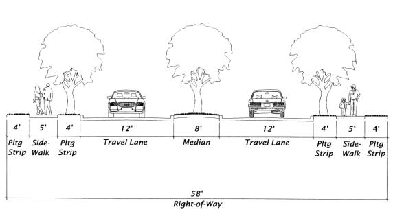
(Ord. 18-06 § 2 (part), 2018: Ord. 17-04 § 2 (part), 2017: Ord. 04-021 § 7 (part), 2004: Ord. 99-004 § 1 (part), 1999: Ord. 95-769 § 1 (part), 1995)
12.116.090 Transportation facilities—Construction bonds.
Bonding shall be provided per BGMC 15.136.060. (Ord. 18-06 § 2 (part), 2018: Ord. 17-04 § 2 (part), 2017: Ord. 09-08 § 6, 2009: Ord. 04-021 § 7 (part), 2004: Ord. 99-004 § 1 (part), 1999: Ord. 95-769 § 1 (part), 1995)
12.116.100 Transportation facilities—Record drawing plans.
Record drawings shall be completed per BGMC 15.136.070. (Ord. 18-06 § 2 (part), 2018: Ord. 17-04 § 2 (part), 2017: Ord. 16-12 § 1 (part), 2016: Ord. 14-07 § 6 (part), 2014: Ord. 04-021 § 7 (part), 2004: Ord. 99-004 § 1 (part), 1999: Ord. 95-769 § 1 (part), 1995)
12.116.110 Transportation facilities—Inspections.
A. General. No construction shall begin until the approval provided for in BGMC 12.116.060 has been obtained. The city engineer’s office shall be notified not less than twenty-four hours prior to the start of any phase of construction.
B. Subgrade. The subgrade must be inspected and approved by the city engineer for application of the base material.
C. Materials. The standard specifications shall apply to all materials and workmanship. Approval of the source of surfacing materials must be obtained from the city engineer prior to using the material on the roadway. The base course shall be thoroughly compacted with approved construction equipment prior to the application of top course. Inspection and approval of the finished base course is required prior to the application of the top course.
D. Paving. The office of the city engineer shall be notified not less than twenty-four hours in advance of the application of any type of paving and, in accordance with the standard specifications, the city engineer may stop or delay paving operations when, in his opinion, the weather or other conditions indicate that suitable results cannot be obtained.
E. Alternate Surface Treatment. Alternate surface treatment may be used only upon written permission of the city engineer. Specifications for materials and application rates will be supplied by the designing engineer subject to approval by the city engineer. (Ord. 18-06 § 2 (part), 2018: Ord. 17-04 § 2 (part), 2017: Ord. 04-021 § 7 (part), 2004: Ord. 99-004 § 1 (part), 1999: Ord. 95-769 § 1 (part), 1995)
12.116.120 Transportation facilities—Acceptance by the city.
Transportation facilities will be accepted for provisional maintenance by the city upon recommendation of the city engineer; provided, prior to such acceptance, a bond in the amount and with surety acceptable to the city engineer, or other secure method, shall be required providing for and securing to the city of Battle Ground the satisfactory performance and maintenance of such transportation improvements for a two-year period. Transportation improvements include all roadways, bicycle and pedestrian facilities and landscaping within public rights-of-way. Final acceptance will be made within two years of the date of provisional acceptance when, in the city engineer’s opinion, all specifications have been fully met. The owner and/or his contractor and the utilities must repair any failure within a period specified by the city engineer at the expense of the owner or his contractor or the utilities responsible. Prior to final acceptance, the city shall require the developer to obtain a revocable license for use of the public right-of-way for entry monuments, landscape medians and other private landscape improvements. Maintenance of such facilities shall be the responsibility of a homeowners association, and shall be stipulated in development conditions, covenants and restrictions (CC&Rs). (Ord. 18-06 § 2 (part), 2018: Ord. 17-04 § 2 (part), 2017: Ord. 04-021 § 7 (part), 2004: Ord. 99-004 § 1 (part), 1999: Ord. 95-769 § 1 (part), 1995)
12.116.130 Transportation facilities—Private streets—General specifications.
A. General Requirements—Applicable to All Private Streets.
1. Private streets, alleys and courts (cul-de-sac streets and streets with hammer-head turnarounds) shall be allowed only for such streets that have no public interest for traffic circulation and are to be built in accordance with the standards adopted in this chapter. Private streets are not allowed when in conflict with the adopted street circulation plans or studies.
2. The city shall not maintain streets, street lights, or signs within private rights-of-way.
3. The cover sheet of any development plan, including subdivision plats, containing a private street shall bear the following language:
The City of Battle Ground has no responsibility to improve or maintain the private streets, including street lights and signs, contained within, or private streets providing access to, the property designed in this development.
4. When three or more lots are served and the road is over one hundred fifty feet in length as measured from the curb of the intersecting street to the end of the road, a turnaround having an improved radius of forty-five feet, or an equivalent, workable maneuvering area, shall be provided at the end of the private street unless modified pursuant to BGMC 12.116.290. Hammer-head designs shall be acceptable as an alternative to the standard forty-five-foot turnaround. Easements may be required to be expanded to accommodate turnaround requirements.
5. A private maintenance agreement shall be required for any development.
6. Private street signs with street designations shall be provided by the developer at the intersection of private streets with private and public streets. Such signs shall meet the specifications shown in the MUTCD as a portion of the standard specifications and, in the case of intersections with public streets, shall either be located within the public right-of-way or a separate maintenance easement shall be provided.
7. Private streets are the responsibility of the developer to construct in accordance with the criteria of this section and BGMC 12.116.140. Upon completion of the required improvements, certification by the developer and his contractor shall be required stating that the improvements have been completed in accordance with the adopted standards.
8. All lots abutting a private street are required to take access from the private street.
B. Reduced Private Street Requirements—When Permitted. The right-of-way width requirements for extensions of existing private streets which were created before the effective date of the ordinance codified in this chapter may be reduced in accordance with the provisions of BGMC 12.116.290 so long as the following are found:
1. No traffic hazard will result; and
2. No additional extensions will be necessary or permitted; and
3. There is no public street access alternative available to serve the additional lots; and
4. The right-of-way of the existing private street cannot be expanded.
C. Units Served—Determination Of.
1. Where potential additional lots are planned to be served by the private street, there shall be established on the plat an easement for roadway and utility installations which provides for future extensions of the private street to serve the remainder of the potential lots for which the street is designed. (Ord. 18-06 § 2 (part), 2018: Ord. 17-04 § 2 (part), 2017: Ord. 14-07 § 6 (part), 2014: Ord. 13-07 § 6, 2013: Ord. 04-021 § 7 (part), 2004: Ord. 99-004 § 1 (part), 1999: Ord. 95-769 § 1 (part), 1995)
12.116.140 Private streets—Design and construction standards.
Private streets shall be constructed in accordance with the criteria set forth in subsection A of this section. Gated streets are prohibited.
A. Urban Private Street Standards.
1. Easement. Private road easement widths shall depend on the potential number of lots or units that may be served in accordance with the following schedule:
|
Potential Number of Lots/Units to Be Served |
Required Easement Width |
|---|---|
|
1—2 |
24 feet |
|
3—4 |
32 feet |
|
5 or more |
48 feet |
Where the street is required for public circulation, as determined by the city engineer, then right-of-way shall be dedicated to the city in accordance with the design criteria of BGMC 12.116.040, within which a private street may not be constructed.
2. Roadway. Private roadway construction shall depend on the actual number of lots or units to be served, in accordance with the following schedule:
|
Actual Number of Lots/Units |
Minimum Surfacing Width Required |
|---|---|
|
1—2 |
22 feet, with no parking on one side |
|
3—4 |
30 feet for roads not longer than 120 feet in length; roads longer than 120 feet in length shall be constructed in conformance with the standards for five or greater lots |
|
5 or more |
A private street meeting Local “A” standards can be built with the approval of the city engineer or when required by BGMC 12.116.205 |
3. Construction. Urban private streets shall be designed and constructed, at a minimum, to support a sixty-two-thousand-pound fire truck and consist of an asphaltic concrete pavement, concrete, or interlocking pavers over a compacted subgrade in accordance with the applicable typical section adopted in subsections (A)(1) and (2) of this section.
4. Street Lights. All private streets shall incorporate decorative street lighting designed in accordance with the latest Illuminating Engineering Society (IES) standards.
5. Plans. Plans for final plat or final short plat private streets shall be prepared and submitted for approval in accordance with the provisions of BGMC 12.116.030 through 12.116.060. (Ord. 23-08 § 1, 2023; Ord. 18-06 § 2 (part), 2018: Ord. 17-04 § 2 (part), 2017: Ord. 16-12 § 1 (part), 2016; Ord. 11-06 § 1, 2011: Ord. 04-021 § 7 (part), 2004: Ord. 00-021 § 1, 2000; Ord. 99-004 § 1 (part), 1999: Ord. 95-769 § 1 (part), 1995)
12.116.145 Private streets—Pedestrian-oriented streets.
A. Pedestrian-oriented streets may be used only when all of the following conditions are met:
1. Requirements of BGMC 12.116.140 are met.
2. The street is not required for public circulation.
3. Homes will be built on both sides of the street.
B. When allowed by subsection A of this section pedestrian-oriented streets shall be built to the following minimum standards:
1. The easement width shall be per BGMC 12.116.140.
2. The minimum sidewalk width shall be ten feet and be built to support emergency and maintenance vehicles.
3. There will be a minimum of two feet on each side of the sidewalk that shall be clear from encroachments including, but not limited to, trees, plants, and structures.
4. Alleys will provide secondary access to lots and must be built to fire code requirements.
5. The maintenance of the sidewalk and all landscaping shall be the responsibility of the homeowners abutting the street. A private road maintenance covenant shall be put in place spelling out the responsibilities of the homeowners. (Ord. 18-06 § 2 (part), 2018: Ord. 17-04 § 2 (part), 2017: Ord. 04-021 § 7 (part), 2004)
12.116.150 Private streets—Maintenance.
A. Each lot, tract or parcel in a subdivision or short subdivision utilizing a private street for access shall have a disclosure statement on the face of the plat or short plat and in the form of a deed covenant running with the land identifying the mutual maintenance responsibilities of each property owner, establishing easements for access and for necessary utilities. (Ord. 18-06 § 2 (part), 2018: Ord. 17-04 § 2 (part), 2017: Ord. 04-021 § 7 (part), 2004: Ord. 99-004 § 1 (part), 1999: Ord. 95-769 § 1 (part), 1995)
12.116.160 Developments—Generally.
Dedicated rights-of-way providing access to a parcel being developed shall have a minimum right-of-way width as specified in the design criteria contained in BGMC 12.116.040. In situations where the property being developed does not permit full public or private streets, half roads having a minimum right-of-way or easement width of one-half of the design width may be permitted when placed adjacent to adjoining property so long as there is no physical obstruction or development constraint prohibiting completion of the road on such adjoining property; provided further, that a half-width public street shall have a minimum roadway width of twenty-five feet unless otherwise approved through the adopted road modification procedures of this chapter. Half roads may not be developed in the following situations: alleys, local “B” streets, and commercial or industrial developments requiring site plan review. (Ord. 18-06 § 2 (part), 2018: Ord. 17-04 § 2 (part), 2017: Ord. 04-021 § 7 (part), 2004: Ord. 00-021 § 1 (part), 2000: Ord. 99-004 § 1 (part), 1999: Ord. 95-769 § 1 (part), 1995)
12.116.170 Developments—Right-of-way.
No development shall occur on any parcel which does not abut a public street right-of-way or private street easement which meets the minimum right-of-way or easement standards set out in BGMC 12.116.040 and 12.116.140; provided, that this prohibition shall not apply to the construction, remodeling or enlargement of any Group R, Division 3 or Group M occupancy (as defined by the currently adopted building code listed in BGMC 15.104.010), to the construction of any accessory residential structure, to any sign, or to the structural addition, alteration or repair to any existing structure within any twelve-month period which neither exceeds twenty-five percent of the value of the existing structure nor increases the total floor space of the structure by more than ten percent.
If the lot abuts an existing publicly maintained street or road, the requirements of this section shall be deemed satisfied in the half width of the right-of-way standards set forth in this chapter. If the lot abuts a private easement or street, such private easement or street shall meet the minimum standards set forth in this chapter along the entire frontage of such lot and along the full-length of the private easement or street from such lot to an opened, constructed and maintained public street; provided, that a half-width private easement or street may be approved pursuant to BGMC 12.116.160. (Ord. 18-06 § 2 (part), 2018: Ord. 17-04 § 2 (part), 2017: Ord. 04-021 § 7 (part), 2004: Ord. 99-004 § 1 (part), 1999: Ord. 95-769 § 1 (part), 1995)
12.116.175 Developments—Traffic impact study.
A. In order to assess the traffic impacts of a proposed development, the planning director or development approval authority will require submittal of a traffic study, unless exempted by subsection C of this section, undertaken by an engineer licensed to practice in the state of Washington with special training and experience in traffic engineering and transportation. The city engineer shall develop guidelines, in accordance with recognized traffic engineering and transportation principles, regarding the content of such studies, which is available from the city.
B. A queuing analysis shall be performed as part of the traffic impact study for any driveway where the queuing distance is under seventy-five feet for arterials, fifty feet for collectors, and twenty-five feet for local streets, as measured from the edge of the right-of-way to the first conflict point.
C. Exemptions.
1. For development of property with an existing use, no traffic impact study shall be required, pursuant to the provisions of this chapter, where the proposed development will generate less than ten new p.m. and a.m. peak hour vehicle trips.
2. For development of bare land, no traffic impact study shall be required, pursuant to the provisions of this chapter, where the proposed development will generate less than ten new p.m. and a.m. peak hour vehicle trips. However, an engineer licensed to practice in the state of Washington with special training and experience in traffic engineering and transportation shall provide a letter addressing trip generation, trip distribution, and any safety related issues, such as but not limited to sight distance. (Ord. 18-06 § 2 (part), 2018: Ord. 17-04 § 2 (part), 2017: Ord. 13-07 § 7, 2013: Ord. 04-021 § 7 (part), 2004)
12.116.180 Developments—Frontage improvements.
A. Unless already fully developed, and subject to the limitations of BGMC 12.116.170 and the modification provisions of BGMC 12.116.290, a half-width road improvement shall be constructed to the applicable standards set out in this chapter to that portion of an access street which abuts the parcel being developed, as a requirement of approval of a final plat, final short plat, site plan application, or conditional use permit; provided, that all projects that are subject to land use or construction permit approval shall be provided adequate vehicular and pedestrian access and based upon an engineering traffic study that will not result in an increase in site trip generation of more than ten percent and shall only be required to make intersection and sight distance frontage improvements in accordance with BGMC 12.116.220 and 12.116.230, unless the city engineer determines that additional frontage improvements are clearly necessary in order to provide minimally safe access to such development. Required private access street improvements shall be completed prior to issuance of final or short plat approval, occupancy, or in accordance with BGMC 12.116.130. Required public access street improvements shall either be completed in like manner or construction thereof shall be guaranteed as provided for in this chapter; provided, that in the event that required public frontage improvements are included as a portion of a city street project scheduled on the city’s comprehensive street program to be undertaken within five years, the developer in lieu of construction or guaranteeing the construction of such frontage improvements may be permitted to contribute a proportionate share towards the cost of the city street project. Such payment obligation may be deferred until after completion of the city street project by a mitigation agreement to pay, constituting a covenant running with the land to be developed or other secure method consistent with the requirements of RCW 82.02.020 and other city of Battle Ground ordinances.
B. Where frontage improvements are required, the developer will construct frontage improvements to the centerline, provided the road has not been constructed or reconstructed to current city standards in the last five years. Where the road has been constructed or reconstructed in the last five years, the improvements shall consist of the new areas and a two-foot overlap of the existing area.
C. If frontage improvements are not required to the centerline, as required by subsection B of this section, then the developer shall mill the remaining asphalt to the centerline if the pavement has a pavement condition index score of seventy or less as determined by the city engineer.
D. When frontage improvements are triggered by subsection A of this section and the development occurs on already improved parcels, if the abutting sidewalk and/or curb ramps do not meet current ADA requirements then they will need to be reconstructed with said development.
E. When frontage improvements are triggered by subsection A of this section and the development abuts a street where frontage improvements are completed on the opposite side of the street then the development shall install full medians when required by the applicable city cross-section in BGMC 12.116.040.
F. When a project is phased, half-width improvements are not allowed between two phases of the same project. The entire width must be constructed with the first phase to go to construction.
G. The city engineer may grant modification to this section on the basis of safety, grade, condition, and/or alignment concerns conditioning such modification, where appropriate and consistent with the requirements of applicable codes upon the property owner’s commitment to participate in a future street improvement district or other method of accomplishing frontage improvements which are anticipated to be needed to serve the development in the future.
H. Nothing in this chapter shall be construed to preclude denial of a proposed development where off-site street conditions are inadequate to provide a minimum level of service, or a significant traffic hazard or hazards would be caused or aggravated by the proposed development; provided, that the developer may voluntarily agree to mitigate such direct impacts in accordance with the provisions of RCW 82.02.020 and this code. (Ord. 22-17 § 1, 2022; Ord. 19-19 § 1 (part), 2019; Ord. 18-06 § 2 (part), 2018: Ord. 17-04 § 2 (part), 2017: Ord. 16-12 § 1 (part), 2016: Ord. 11-06 § 2, 2011: Ord. 04-021 § 7 (part), 2004: Ord. 99-004 § 1 (part), 1999: Ord. 95-769 § 1 (part), 1995)
12.116.190 Developments—Access streets—Drainage.
Access street drainage facilities shall be sufficient to prevent water damage or impairment from normal rain flow or surface water, in accordance with Chapter 18.250 BGMC, Stormwater Control and Drainage. (Ord. 18-06 § 2 (part), 2018: Ord. 17-04 § 2 (part), 2017: Ord. 04-021 § 7 (part), 2004: Ord. 99-004 § 1 (part), 1999: Ord. 95-769 § 1 (part), 1995)
12.116.200 Developments—Cross streets.
The city’s intent is to facilitate the development of an efficient street grid network in conformance with the adopted transportation plan for the city of Battle Ground. On all dedicated rights-of-way exceeding five hundred feet in length, cross streets shall be provided at intervals not greater than five hundred feet in length, regardless of property width or depth; provided, in order to minimize through traffic in residential neighborhoods, an overall development plan providing longer intersection intervals may be approved so long as it provides adequate vehicular circulation in the vicinity of the development; provided further, that when cross street spacing exceeds five hundred feet, pedestrian walkways connecting streets shall be required; provided further, that alternative cross street design shall be required. The cross streets shall extend the full depth of the property at approximate right angles to the dedicated right-of-way and shall provide for a minimum width as specified in BGMC 12.116.040. Cross streets shall be aligned to join the existing streets at the terminal points for developing circulation of traffic. (Ord. 18-06 § 2 (part), 2018: Ord. 17-04 § 2 (part), 2017: Ord. 04-021 § 7 (part), 2004: Ord. 01-003 § 1 (part), 2001: Ord. 99-004 § 1 (part), 1999: Ord. 95-769 § 1 (part), 1995)
12.116.205 Developments—Cul-de-sacs—Hammer-heads—Dead ends.
When cul-de-sacs, hammer-heads, or dead ends are approved for purposes of access management, the landscaped parkway requirement of BGMC 16.125.100 must be provided on the street where the cul-de-sac, hammer-head, or dead end is managing access. The parkway must be provided for any lot whose side or rear yard abuts the street. The parkway will be maintained by the developer or homeowners association unless accepted by the city. When cul-de-sacs, hammer-heads, or dead ends, except temporary, are approved for any purpose they will be considered private streets and be privately maintained unless accepted by the city. (Ord. 18-06 § 2 (part), 2018: Ord. 17-04 § 2 (part), 2017: Ord. 16-12 § 1 (part), 2016)
12.116.210 Intersection design.
Private and public streets shall be laid out so as to intersect at an angle as near to a right angle as practicable, but in no case less than sixty degrees for residential road intersections and no less than seventy-five degrees for roads intersecting arterials unless modified pursuant to BGMC 12.116.290. Intersections of local streets shall have a minimum curb radius of twenty feet, intersections of a local street with a collector street shall have a minimum curb radius of twenty-five feet, and intersections of two collectors or any street with an arterial shall have a minimum curb radius of thirty-five feet. Larger curb radii may be required by the city engineer to accommodate large vehicle turning movements and/or ADA ramps. (Ord. 18-06 § 2 (part), 2018: Ord. 17-04 § 2 (part), 2017: Ord. 14-07 § 6 (part), 2014: Ord. 04-021 § 7 (part), 2004: Ord. 99-004 § 1 (part), 1999: Ord. 95-769 § 1 (part), 1995)
12.116.215 Intersection alignment.
Private and public streets shall be laid out so that the centerline of streets aligning at an intersection shall match where possible with a maximum six-foot offset allowable. Streets not meeting this standard shall meet the intersection spacing standards of BGMC 12.116.040 unless allowed by BGMC 12.116.080 (Traffic calming measures) or modified by BGMC 12.116.290. (Ord. 18-06 § 2 (part), 2018: Ord. 17-04 § 2 (part), 2017: Ord. 04-021 § 7 (part), 2004)
12.116.220 Sight distances.
Unless modified pursuant to BGMC 12.116.290, public and private streets shall comply with the following sight distance clearance requirements:
A. Stopping Sight Distance. Public streets shall have adequate stopping sight distance as measured from a driver’s eye height in a standard passenger car of three and one-half feet above the roadway surface to a roadside target nominally two feet in height above the roadway surface, in accordance with the following table:
|
Posted Speed (mph) |
Minimum Stopping Distance* (feet) |
|---|---|
|
25 |
150 |
|
30 |
200 |
|
35 |
250 |
|
40 |
325 |
|
45 |
400 |
|
50 |
475 |
* Grades steeper than three percent refer to the current AASHTO “Policy on Geometric Design of Highways and Streets.”
B. Controlled Intersection Sight Distance Triangle. Public streets, private streets, and driveways, which are controlled by a stop sign at an intersection with an uncontrolled public street, shall have adequate sight distance clearance as measured from a seeing height of three and one-half feet above the roadway surface on the controlled street at least fifteen feet from the edge of the uncontrolled public street to an object height on the uncontrolled public street of four and one-half feet above the roadway surface, in accordance with the following table:
|
Posted Speed Uncontrolled Street (mph) |
Minimum Sight Distance* (feet) |
|---|---|
|
25 |
250 |
|
30 |
300 |
|
35 |
350 |
|
40 |
400 |
|
45 |
450 |
|
50 |
500 |
* Grades steeper than three percent refer to the current AASHTO “Policy on Geometric Design of Highways and Streets.”
C. Uncontrolled Intersection Sight Distance Triangle. Submit design for the approval of the city engineer.
D. Alley Sight Distance Triangle. Where alleys intersect with streets or other alleys they shall have adequate sight distance as required in subsection B of this section.
E. Obstructions within Sight Distance Triangle. The following are allowed within the sight distance triangle: single-trunk trees, power poles, street lights, traffic signage, and objects and vegetative plantings under forty-two inches in height.
F. Signing. The city engineer may require installation of appropriate warning or stop and private street designation signs as a condition of approving a private access intersection with a public street. Such installation shall be at the applicant’s expense.
G. Modifications. The provisions of this section shall take precedence over any building setback, except in any commercial district, where the city engineer may authorize lesser requirements upon finding that the public health, safety, and welfare will not be adversely impacted. Additionally, the sight distance triangle standards may be modified by the city engineer, in accordance with BGMC 12.116.290, upon review of evidence which shows that traffic speeds or physical conditions warrant a different standard. Such evidence may include radar speed studies or traffic accident history and shall comply with the requirements of the MUTCD. (Ord. 18-06 § 2 (part), 2018: Ord. 17-04 § 2 (part), 2017: Ord. 16-12 § 1 (part), 2016; Ord. 14-07 § 6 (part), 2014: Ord. 09-08 § 7, 2009: Ord. 04-021 § 7 (part), 2004: Ord. 01-003 § 1 (part), 2001: Ord. 99-004 § 1 (part), 1999: Ord. 95-769 § 1 (part), 1995)
12.116.230 Street extensions.
Where a public or private street has been constructed or created in such a manner as to be able to be extended or widened in accordance with adopted street plans or this chapter, then:
A. All residences, buildings or structures shall be constructed in such a position on the property that they will not interfere with the extension or widening of the roadway to adjacent areas and shall be so situated that such extension will make orderly and planned development for additional street installations to meet the reasonable minimum requirements of good and safe traffic circulation; and
B. Right-of-way or private easements necessary to such extension or widening and falling within parcels being developed shall be granted or created as a condition of development approval. The city engineer may require the provisions of a temporary vehicular turn-around area at a street end for fire and life safety purposes. (Ord. 18-06 § 2 (part), 2018: Ord. 17-04 § 2 (part), 2017: Ord. 04-021 § 7 (part), 2004: Ord. 99-004 § 1 (part), 1999: Ord. 95-769 § 1 (part), 1995)
12.116.240 Developments—Off-site and extra-capacity improvements.
Dedication of arterial and collector rights-of-way shall occur within developments in accordance with the transportation element of the city of Battle Ground’s comprehensive plan. In the case of a development containing an arterial or collector street, or fronting on an arterial or collector street, the developer shall only be required to construct half-width improvements, including curbs, sidewalks, travel lanes, bicycle lanes, street trees and other required street landscaping, in conformance with BGMC 12.116.040. Construction of a wider section may be required by the development review authority as necessary to accommodate the development. The developer may also be required to construct or financially contribute toward construction of off-site transportation improvements which are necessary to accommodate the development. When “extra-capacity improvements” are required as a condition of development approval, the developer may receive credit toward required impact/mitigation fees, in accordance with BGMC 12.116.180 and RCW 82.02.020. Extra-capacity improvements are those improvements which are in addition to those required to mitigate development impacts. (Ord. 18-06 § 2 (part), 2018: Ord. 17-04 § 2 (part), 2017: Ord. 04-021 § 7 (part), 2004: Ord. 99-004 § 1 (part), 1999: Ord. 95-769 § 1 (part), 1995)
12.116.243 Residential driveways.
A. Spacing. Driveways must be a minimum of five feet from the property line, as measured from the edge of the throat, the portion of the driveway before the transition back to the curb begins, unless the driveway serves as a shared driveway between two lots. Driveways on corner lots shall be as far away from the intersection as this section allows. When a corner lot abuts an arterial, the lot abutting the arterial must share a driveway with the abutting lot unless there is one hundred five feet of spacing.
B. Width. Maximum single-family residential driveway width is twenty-five feet for a two-car garage and thirty-five feet for a three-car garage or fifty percent of the lot frontage, whichever is less. Maximum multifamily residential driveway width is thirty-five feet or fifty percent of the lot frontage, whichever is less. Width is throat width (bottom of wing to bottom of wing).
C. Number of Driveways.
1. Single-Family Residential. Only one driveway per lot is allowed unless approval is granted by the development review authority for a second driveway. Approval of a second driveway will only be allowed if the requirements of BGMC 12.116.290, Modifications, are met.
2. Multifamily Residential. For developments with one hundred units or more, a minimum of two driveways are required. The total number of driveways allowed will be determined by the development review authority.
D. Shared Driveways. Shared driveways are allowed and even encouraged between two or more lots. When a lot is less than forty feet in width and not served by an alley a shared driveway must be used.
E. Exemptions. Residential driveways on major collectors and arterials shall be controlled by BGMC 12.116.040 and/or 12.116.260. (Ord. 19-19 § 1 (part), 2019; Ord. 18-06 § 2 (part), 2018: Ord. 17-04 § 2 (part), 2017: Ord. 10-08 § 1, 2010; Ord. 04-021 § 7 (part), 2004)
12.116.246 Nonresidential driveways.
A. Spacing. Driveways must be a minimum of five feet from the property line, as measured from the edge of the throat, the portion of the driveway before the transition back to the curb begins, unless the driveway serves as a shared driveway between two lots. Driveways on corner lots shall be as far away from the intersection as this section allows. When a corner lot abuts an arterial, the driveway must be two hundred fifty feet from the arterial. When a corner lot abuts a major collector, the driveway must be one hundred five feet from the major collector. If lot width prevents this spacing requirement then the driveway must be placed as far back as possible. Driveways placed on neighborhood collectors shall be spaced one hundred five feet apart.
B. Width. Driveway width shall be fifteen to thirty-five feet. Width is throat width (bottom of wing to bottom of wing).
C. Number of Driveways. The number of driveways shall be determined by the development review authority based on a traffic impact analysis and with consideration to the following guidelines.
1. Driveway average daily trips (ADT) over one thousand trips, provide two driveways;
2. Driveway average daily trips (ADT) over five thousand trips, provide additional driveways.
D. Shared Driveways. Shared driveways between users on the same or abutting properties shall be required wherever possible.
E. Exemptions. Nonresidential driveways on major collectors and arterials shall be controlled by BGMC 12.116.040 and/or 12.116.260. (Ord. 18-06 § 2 (part), 2018: Ord. 17-04 § 2 (part), 2017: Ord. 16-12 § 1 (part), 2016; Ord. 10-08 § 2, 2010; Ord. 04-021 § 7 (part), 2004)
12.116.250 Arterials—Residential street intersections.
In order to limit the number of residential streets intersecting with arterials while providing adequate neighborhood circulation, residential streets intersecting with arterials shall be classified and constructed to standards applicable to neighborhood collector streets or major collector streets (BGMC 12.116.040) unless the city engineer finds that a lesser classification adequately provides for the circulation needs of the surrounding area. In those cases in which a local or collector street is approved, such street shall have a minimum width of the required standard or no less than twenty-eight feet at the intersection with the arterial and shall be tapered as required by the city engineer. A neighborhood entry or landscape median may be required at the intersection in accordance with the traffic calming standards of BGMC 12.116.080. (Ord. 18-06 § 2 (part), 2018: Ord. 17-04 § 2 (part), 2017: Ord. 04-021 § 7 (part), 2004: Ord. 99-004 § 1 (part), 1999: Ord. 95-769 § 1 (part), 1995)
12.116.260 Major collectors and arterials—Access policy.
A. Spacing. Driveways on major collectors and arterials, when allowed, shall be spaced in accordance with the following table:
|
Arterial/Major Collector Speed |
Minimum Separation* (feet) |
|---|---|
|
20 |
85 |
|
25 |
105 |
|
30 |
125 |
|
35 |
150 |
|
40 |
185 |
|
45 and over |
230 |
* Distances between adjacent one-way driveways with the inbound drive upstream from the downstream drive may be one-half the distance shown. Residential driveways may be clustered to meet the required separation.
B. Width. A residential driveway onto a major collector or an arterial shall be fifteen to twenty feet wide for one-way traffic and thirty-five feet wide maximum for two-way traffic. Nonresidential driveways onto an arterial shall be fifteen to thirty-five feet in width; driveways for two-way traffic (nonresidential) shall be the minimum width necessary to accommodate traffic generated by the development. Driveway requests larger than thirty-five feet shall require an AutoTURN analysis provided by a registered engineer in the state of Washington.
C. Corner Clearance. To provide adequate corner clearance, the tangent street shall be fifty feet. Where the intersection is signalized or is planned for signalization, driveways shall be limited to right turn movements if located within one hundred seventy-five feet on major collectors and two hundred fifty feet on minor and principal arterials.
D. Number of Driveways. The number of driveways and driveway lanes shall be determined by the city engineer based upon a traffic analysis and with consideration to the following guidelines:
1. Driveway average daily trips (ADT) over one thousand, provide two driveway exit lanes;
2. Driveway average daily trips (ADT) over five thousand, provide additional driveway or driveways.
E. Shared Driveways. Shared driveways between users on the same or abutting properties shall be required wherever possible.
F. Additional Improvements. The installation of other improvements such as left turn lanes, right turn lanes and traffic signals may be required by the city engineer where found necessary on the basis of a traffic engineering study. Such study may be required by the developer prior to approval by the city engineer. (Ord. 18-06 § 2 (part), 2018: Ord. 17-04 § 2 (part), 2017: Ord. 04-021 § 7 (part), 2004: Ord. 99-004 § 1 (part), 1999: Ord. 95-769 § 1 (part), 1995)
12.116.270 Developments—State access roads.
If the access road serving a development is a state road or highway, required dedication and/or improvements thereto shall be governed by the provisions of this chapter dealing with city access roads unless specified otherwise by the Washington State Department of Transportation. (Ord. 18-06 § 2 (part), 2018: Ord. 17-04 § 2 (part), 2017: Ord. 04-021 § 7 (part), 2004: Ord. 99-004 § 1 (part), 1999: Ord. 95-769 § 1 (part), 1995)
12.116.280 Permits.
Permits will be issued pursuant to Chapter 12.118 BGMC. (Ord. 18-06 § 2 (part), 2018: Ord. 17-04 § 2 (part), 2017: Ord. 04-021 § 7 (part), 2004: Ord. 99-004 § 1 (part), 1999: Ord. 95-769 § 1 (part), 1995)
12.116.290 Modifications.
A. Quasi-judicial modification requests pertaining to development actions to street standards shall only be granted when the applicant for said modification can demonstrate conformity to BGMC 12.116.010(B) and demonstrates the following criteria are met:
1. There are topographical or physical conditions such as steep slopes, wetlands, water area, structures, streets, utilities, lot patterns, street patterns, or other conditions that justify departure from strict adherence to the standard to be modified;
2. That the modification is consistent with sound engineering principles and it will be safe, practical, and efficient;
3. That the proposed modification is consistent with the intent and purpose of the standard being modified; and
4. That the proposed modification is consistent with the goals and policies of the comprehensive plan.
B. Applicants for a road modification shall make a written request addressing this section of the code and shall make such requests to the attention of the city engineer. Applications for road modifications shall be processed consistent with Chapter 17.200 BGMC. Where an underlying development application is involved, the modification request shall be considered concurrently with such application. Appeals of a decision on a road modification shall be made consistent with BGMC 17.200.140.
C. The city engineer may modify the technical design standards contained within this chapter to achieve best engineering practices or accommodate physical constraints for public road projects identified on the city’s capital facilities plan. If the modification being sought is a significant departure from the adopted standards, then the modification should be considered through the city’s legislative amendment process. Where the city council has approved an alternate public involvement process as part of the public project, the city engineer may refer the modification to the city council for review and approval. Where the city council has not approved an alternate public involvement process as part of the public project, the city engineer may refer the modification for review as a legislative amendment under the provisions of BGMC 17.200.075. (Ord. 18-06 § 2 (part), 2018: Ord. 17-04 § 2 (part), 2017: Ord. 16-12 § 1 (part), 2016; Ord. 04-021 § 7 (part), 2004: Ord. 00-021 § § 1, 4 (part), 2000; Ord. 99-004 § 1 (part), 1999: Ord. 95-769 § 1 (part), 1995)
12.116.295 Conflicting road standards.
Where there is a conflict between the requirements of this chapter and the fire code, the provisions of this chapter shall prevail, except BGMC 12.116.145(B)(4). (Ord. 18-06 § 2 (part), 2018: Ord. 17-04 § 2 (part), 2017: Ord. 04-021 § 7 (part), 2004)
12.116.300 Construction details.
The city of Battle Ground’s construction details for transportation facilities are maintained by the city engineer and on file at City Hall. (Ord. 18-06 § 2 (part), 2018: Ord. 17-04 § 2 (part), 2017: Ord. 16-12 § 1 (part), 2016: Ord. 04-021 § 7 (part), 2004: Ord. 99-004 § 1 (part), 1999)