


Chapter 18.10
CRITICAL AREAS
Sections:
18.10.060 Applicability – Regulated activities.
18.10.080 Critical areas permits – Applications and approvals.
18.10.090 Optional incentives for nondevelopment of critical areas.
18.10.100 Relationship to other regulations.
18.10.110 Critical area inventory maps.
18.10.120 Critical area wetlands.
18.10.130 Fish and wildlife habitat conservation areas.
18.10.140 Frequently flooded critical areas.
18.10.150 Geologic hazard areas.
18.10.160 Critical aquifer recharge areas.
18.10.170 Mitigation plan performance standards.
18.10.210 Penalties – Violations.
18.10.230 Liability for damages.
Appendix 18.10A Qualified expert and valid scientific process.
Appendix 18.10B Geotechnical assessments.
Appendix 18.10C Geotechnical report.
Appendix 18.10D Erosion hazard assessments.
Appendix 18.10E Wetland assessment.
Appendix 18.10F Habitat management plan requirements.
Appendix 18.10G Hydrogeologic testing and site evaluation.
Figure 1 Overall critical areas.
Figure 2 Critical area – Wetland.
Figure 3 Critical area – Special flood hazard area (SFHA).
Figure 4 Critical area – Severe soils.
Figure 5 Critical area – Steep slopes.
18.10.010 Title.
This chapter is known as the city of Castle Rock critical areas protection ordinance. [Ord. 2002-03 Att. A § 1, 2002].
18.10.020 Preamble.
The city has responded to state mandates contained in the Growth Management Act, RCW 36.70A.060, by developing and adopting the ordinance codified in this chapter which classifies, designates, and protects critical areas. The city believes it important to strike a balance between critical land protection, private property rights, economic development and diversification. Consequently, this chapter has been designed to encourage landowners to protect critical areas by offering a range of incentives intended to provide equitably for such protection. In addition, it is the intent of the city to actively and constructively assist the applicant in the preparation and processing of permits, approvals, plans, requirements or procedures. The ultimate responsibility for providing complete and accurate application material and/or required information falls on the applicant.
A limited amount of scientific data is available to address all critical areas within the city. As more information becomes available, it will be incorporated. [Ord. 2002-03 Att. A § 2, 2002].
18.10.030 Purpose and intent.
A. The state of Washington’s Growth Management Act requires the city to adopt development regulations affecting certain types of land to assure the conservation of such areas. This chapter is intended to comply with this state mandate. “Critical areas” include: wetlands, aquifer recharge areas, geologically hazardous areas, fish and wildlife habitat, and frequently flooded areas. These areas contain valuable natural resources, provide natural scenic qualities important to the character of the community, perform important ecological functions and processes, or present a hazard to life and property. Identification, management, and protection of these lands and areas is, therefore, necessary to protect the public health, safety, and general welfare of Castle Rock’s citizens. This chapter also describes the process used to determine if a critical area exists on or adjacent to a particular parcel of land. The process includes the use of maps, physical inspections and other methods of fact-finding. It is the intent of the city to use, with this chapter, the best available science and data in making a critical area determination. It is the intent of this chapter to:
1. Implement the goals, objectives, and policies of the environmental and land use elements of the city’s comprehensive plan;
2. Comply with the requirements of the Growth Management Act (Chapter 36.70A RCW) which mandate such rules and guidelines;
3. Coordinate Castle Rock’s critical area protection activities and programs with those of other jurisdictions;
4. Coordinate environmental review and permitting of proposals to avoid duplication and delay;
5. Assist landowners by providing incentives for critical area protection.
It is therefore incumbent upon the developer or proponent of an action, when it is determined that a critical areas permit is required, to work with the city to meet all permit requirements. Also, providing to the city staff all identified studies and requested analyses of the project’s potential environmental impacts, as per RCW 36.70A.172, which directs cities and counties to use the best available science when reviewing proposals that are found to require a critical areas permit.
B. Critical Areas Functions.
1. Wetlands. Wetlands provide numerous valuable functions, including but not limited to providing wildlife and fish habitat areas, water quality enhancement, flood and erosion control, aquifer recharge and discharge, shoreline stabilization, research and education opportunities, and recreation.
2. Geologic Hazards. Geologic hazards pose a risk to public and private property and to the natural systems that make up the city’s environment. These lands are susceptible to slides, erosion, seismic effects, and volcanic and mining hazards. Building and development practices should consider topographical and geological features. Future development shall be directed to more geologically stable areas and restricted on unsuitable ground. Regulating these lands and avoiding or minimizing alteration of geologic hazards is necessary to protect the health, safety, and general welfare; therefore, two categories have been established for review which are as follows: potentially geologically hazardous areas which require more extensive review because of the severity of conditions and areas of geological concern which may only require a minimal amount of geological information with recommendations for site development suitability.
3. Aquifer Recharge Areas. Aquifer recharge areas perform many important biological and physical functions that benefit the city and its residents, including but not limited to storing and conveying groundwater. Protection of aquifer recharge areas is, therefore, necessary to protect the public health, safety, and general welfare.
4. Fish and Wildlife Habitat Conservation Areas. Fish and wildlife habitat conservation areas perform many important physical and biological functions that benefit the city and its residents. These functions include but are not limited to: food, cover, nesting, breeding and movement areas for fish and wildlife; maintaining and promoting diversity of species and habitat; maintaining air and water quality; controlling erosion; providing for recreation, education and scientific study and aesthetic appreciation; and providing neighborhood separation and visual diversity within urban areas.
5. Frequently Flooded Areas. Frequently flooded areas pose a risk to public and private property and public health. Regulation of these lands will promote efficient use of the land and water resources by allocating frequently flooded areas (as determined by the Federal Emergency Management Agency’s Flood Rate Insurance Maps) to the uses for which they are best suited and to discourage obstructions to flood-flows or uses which pollute or deteriorate natural waters and watercourses. [Ord. 2002-03 Att. A § 3, 2002].
18.10.040 Authority.
The ordinance codified in this chapter is adopted under the authority of Chapter 36.70A RCW. [Ord. 2002-03 Att. A § 4, 2002].
18.10.050 Definitions.
For the purposes of this chapter, the following definitions shall apply unless the context clearly requires otherwise. It is further acknowledged that several of the following terms appear in other codes and those may be slightly different than those contained in this code.
“Adjacent to” means immediately adjoining (in contact with the boundary of the subject area) or within a distance that is less than that needed to separate activities from critical areas to ensure protection of the function and values of the critical areas. “Adjacent to” shall also mean any activity or development located:
1. On a site immediately adjoining a critical area;
2. A distance equal to or less than the required critical area buffer or zoning and building setback requirements;
3. A distance equal to or less than one-half mile (2,640 feet) from a bald eagle’s nest;
4. A distance equal to or less than 300 feet upland from a stream, wetland or water body;
5. Bordering or within the floodway, floodplain, or channel migration zone; or
6. A distance equal to or less than 200 feet from a critical aquifer recharge area.
“Agricultural activities (existing and ongoing)” means those activities conducted on lands defined in RCW 84.34.020(2), Open space, agricultural, timber lands – Current use – Conservation futures, and those activities involved in the production of crops and livestock, including but not limited to operation and maintenance of existing farm and stock ponds or drainage systems, irrigation systems, changes between agricultural activities, and maintenance or repair of existing serviceable structures and facilities. Activities which bring an area into agricultural use are not part of an ongoing activity. An activity ceases to be ongoing when the area on which it was conducted has been converted to a nonagricultural use or, with the exception of forest practices, has been unattended for five years.
“Alluvial fan” means a low, outspread, relatively flat to gently sloping mass of loose alluvium, shaped like an open fan, deposited by a stream where it issues from a narrow valley, or where a tributary stream issues into the main stream, or wherever a constriction in a valley abruptly ceases or the gradient of the stream suddenly decreases; it is steepest near the mouth of the valley where its apex points upstream, and it slopes gently and convexly outward with gradually decreasing gradient.
“Alluvium” means sand, clay, etc., gradually deposited by moving water, as along a riverbed, stream or shore of a lake.
“Alteration” means a human-induced action which materially affects a regulated critical area or associated buffer, such as a physical change to the existing condition of land or improvements, including but not limited to construction, clearing, filling, and grading.
“Applicant” means the person, party, firm, corporation, Indian tribe, or federal, state or local government, or any other entity that proposes any activity that could affect a critical area.
“Aquifer recharge area” means areas where water infiltrates the soil and percolates through it and surface rocks to the groundwater.
“Best available science” means scientific methodology that is the product of a valid scientific process. Such a process will have undergone peer review (see Appendix 18.10A), be replicable, contain logical conclusions and reasonable inferences, and be based on scientific research, inventories, surveys, assessments and/or statistical analysis conducted by a qualified scientific expert.
“Best management practices” means systems of practices and management measures that: (1) control soil loss and reduce water quality degradation caused by nutrients, animal waste, and toxins; (2) control the movement of sediment and erosion caused by land alteration activities; (3) avoid adverse impacts to surface and groundwater quality, flow, and circulation patterns; and (4) avoid adverse impacts to the chemical, physical, and biological characteristics of a critical area.
“Buffer” or “buffer area” means an area established to protect the integrity or functions and values of a critical area from potential adverse impacts.
“Clearing” means the removal of trees, brush, grass, ground cover, or other vegetative matter from a site.
“Conservation easement” means an interest or right of use over a property, less than fee simple (means that the easement has been conveyed to the public by deed or other document, but the actual land stays with the original landowner), to protect, preserve, maintain, improve, restore, limit the future use of, or conserve for open space purposes any land or improvement on the land.
“Construction” means any act or process that requires a building or fill and grading permit, and/or that adds an addition onto an existing building or erects a new principal or accessory structure on a lot which is subject to the design standards for the district in which the property is located.
“Council” means Castle Rock city council.
“Critical” means dangerous or risky lands and/or waters. Those land and water areas that have either caused a danger to human life and property or are understood through existing knowledge to pose a risk of becoming dangerous to human life and property, or those lands and waters sensitive to fish and wildlife habitat conservation.
“Critical areas” means a geographic or identifiable location or site and includes the following areas and ecosystems: (1) wetlands; (2) areas with a critical recharging effect on aquifers used for potable water; (3) fish and wildlife habitat conservation areas (WAC 365-190-080(5)(c)); (4) frequently flooded areas; and (5) geologically hazardous areas (RCW 36.70A.030).
Department. (Not identified.)
“Development” means a construction project involving property improvement or a change of physical character within the site; the act of using land for building or extractive purposes. “Development” shall include, but shall not be limited to, the activities identified in CRMC 18.10.060.
“Edge” means the outer edge of a stream’s bank width or, where applicable, the ordinary high water mark.
“Enhancement” means actions performed to improve the condition or functions and values of an existing viable wetland or buffer, or fish and wildlife habitat area or buffer. Enhancement actions include but are not limited to increasing plant diversity, increasing fish and wildlife habitat, installing environmentally compatible erosion controls, and removing invasive plant species such as milfoil and loosestrife.
Erosion Hazard Area. See “geologic hazard areas.”
“ESA” means the Endangered Species Act, specifically Section (4)(d), Protective Regulations.
“Excavation” means the mechanical removal of earth material.
Existing and Ongoing Agricultural Activities. See “agricultural activities.”
“Filling” means the act of placing fill material (on any critical area) including temporary stockpiling of fill material.
“Fill material” means a deposit of earth or other natural or manmade material placed by artificial means.
“Fish,” as used in this chapter, refers to resident game fish; anadromous fish and specified salmonoids listed as endangered or threatened under the Federal Endangered Species Act, Section (4)(d), or the Washington State List of Threatened and Endangered Species.
“Fish and wildlife habitat conservation areas” means those habitats designated by WAC 365-190-080(5)(a) and include all areas listed in the WAC.
“Geologic hazard areas” means areas susceptible to erosion, sliding, earthquake, or other geologic events (see CRMC 18.10.150 for classifications).
“Geologist” means a person who is licensed as a professional geologist in Washington State in accordance with Chapter 18.220 RCW.
“Geotechnical assessment” means an assessment prepared by a geotechnical engineer licensed by the state of Washington, which evaluates the site conditions and the effects of a proposal, and identifies mitigating measures to ensure that the risks associated with geologic hazards will be substantially reduced. See Appendix 18.10A.
“Geotechnical engineer (engineering geologist)” means a practicing geotechnical/civil engineer licensed as a professional civil engineer with the state of Washington, who is also licensed as a professional geologist in Washington State in accordance with Chapter 18.220 RCW.
“Geotechnical report” means a report prepared by a geotechnical engineer including a description of the site geology, conclusions, and recommendations regarding the effect of geologic conditions on the proposed development, opinions and recommendations of the adequacy of the site to be developed, the effects of groundwater interception and infiltration, seepage, potential slip planes, and changes in soil bearing strength, and the impacts of the proposed development and appropriate mitigating measures. See Appendix 18.10B.
“Grading” means an excavating and/or filling of the earth’s surface or combination thereof.
“Hydric soils” means soils which are wet long enough to periodically produce anaerobic (reduced oxygen) conditions, thereby influencing plant growth.
“Hydrogeologist” means a person who is licensed as a professional hydrogeologist in Washington State in accordance with Chapter 18.220 RCW.
“Hydrologic unit (watershed)” means an area of land above or upstream from a specific point on a stream, which is enclosed by a topographic divide (i.e., hillsides, mountains, cliffs, etc.) such that direct surface runoff from precipitation normally drains by gravity into the stream or the area above the specified point on a stream.
“Indigenous” means any native species of plant or wildlife that occurs naturally on a particular site or area.
“International Building Code” means the Washington State International Building Code’s most currently adopted edition, as adopted by the city.
“Lake” means a naturally existing or artificially created body of standing water, including reservoirs, 20 acres or greater in size, which exists on a year-round basis and occurs in a depression of land or expanded part of a stream.
“Landfill” means a disposal facility or part of a facility at which solid waste is placed in or on land.
“Landslide” means abrupt downslope movement of a mass of soil or rock.
Landslide Hazard Area. See CRMC 18.10.150(C).
“Liquefaction” means a process in which soil loses strength, and behaves like a liquid.
“Mitigation” means compensating action designed to replace project-induced critical area losses or impacts, including, but not limited to, avoiding, minimizing, or compensating for adverse wetland impacts.
1. In-Kind Mitigation. Replacement of wetlands or surface water systems with substitute wetlands or surface water systems whose characteristics and functions and values closely approximate those destroyed or degraded by a regulated activity.
2. Out-of-Kind Mitigation. Replacement of surface water systems or wetlands with substitute surface water systems or wetlands whose characteristics do not closely approximate those destroyed or degraded by a regulated activity.
“Mitigation plan” means a plan that outlines the activities that will be undertaken to alleviate project impacts. The plan generally contains: a site and project description; an environmental assessment of the functions and values of the site that will be impacted; a description of the proposed mitigation; the goals and objectives of the proposed mitigation; the performance standards against which success will be measured; monitoring of and reporting on the success of the mitigation; and a contingency plan in case of failure.
“Noxious weeds” means any plant which, when established, is highly destructive, competitive, or difficult to control. The county maintains a noxious weed list.
“Open space” means land eligible for tax assessment at its current use value as authorized by Chapter 84.34 RCW.
“Pond” means a naturally existing or artificially created body of standing water which exists on a year-round basis and occurs in a depression of land or expanded part of a stream.
“Priority habitat” means those habitat types or elements with a unique or significant value to a diverse assemblage of species. A priority habitat may consist of a unique vegetation type or dominant plant species, a described successional stage, or a specific structural element.
“Priority species” means fish and wildlife species requiring protective measures and/or management guidelines to ensure their perpetuation as determined by the Washington State Department of Fish and Wildlife’s Priority Habitats and Species List, as now exists or is hereafter amended.
“Qualified expert,” for the purposes of these regulations, means a person who has received a degree from an accredited college or university in a field necessary to identify and evaluate a particular critical area, and/or a person who is professionally trained, licensed and certified in such field(s). Areas of technical expertise shall generally be as follows: wetlands biology or ecology (for wetlands); stream and/or fisheries biology or ecology (for streams); wildlife biology or ecology (for critical habitat); or a licensed geologist, hydrogeologist or engineering geologist (most frequently referred to as a geotechnical engineer) for geologic hazard areas in accordance with Chapter 18.220 RCW. When a landscape or planting plan is required by these regulations, a qualified expert is one who has demonstrated expertise in the use of indigenous plant species, slope stabilization, and arboricultural practices. Professionals shall be required to demonstrate the basis for their qualifications, and submit copies of past reports that have been accepted by other jurisdictions on critical area permit applications. A demonstration of qualifications may include, but shall not be limited to, submission of a copy of professional certification, such as either a graduate certificate or state license.
Regulated Activity. It is recognized that activities such as those described herein are also covered by other codes and ordinances, such as the IBC regulations regarding excavating and grading. The purpose of this definition is for the determination as to whether or not a particular activity needs a critical areas permit. Not requiring a critical areas permit does not exclude the requirement for a building permit. Activities occurring in a critical area or associated buffer are subject to the provisions of this chapter. Regulated activities generally include but are not limited to any filling, dredging, dumping or stockpiling, draining, excavation, grading, flooding, construction or reconstruction, driving pilings, obstructing, shading, clearing or harvesting.
Regulated Wetland. Washington State Department of Ecology’s Publication No. 97-112, February 1998, titled How Ecology Regulates Wetlands, pages 8 and 9, presents the following definition on regulated wetlands:
In understanding wetland regulation it is important to distinguish between “biological,” “jurisdictional,” and “regulated” wetlands. (1) Biological wetland: A biological wetland is one that is determined (by a qualified expert) to have the physical, biological and chemical characteristics to be called a “wetland” [see definition of “wetland” in this section]; (2) Jurisdictional wetland: A jurisdictional wetland is one that a particular law has determined should be regulated by the provisions of the law. It may be the same as a biological wetland or it may represent a subset of biological wetlands. For example, the Shoreline Management Act has defined wetlands under its jurisdiction as being all wetlands associated with tidal waters and certain lakes and streams. Most freshwater wetlands in the state are not within the shorelines jurisdiction. The SMA definition further restricts jurisdictional wetlands by specifically excluding artificial wetlands intentionally created from nonwetland sites such as canals, farm ponds and landscape amenities. Thus, even though some of these areas may meet the above biological definition, the SMA would not regulate them; (3) Regulated wetland: While most jurisdictional wetlands are going to be regulated to some extent, there are always certain activities that are exempt from a given law. This results in some jurisdictional wetlands not being regulated. For example, a wetland may fall under SMA jurisdiction because it meets the specific criteria contained in the SMA wetland definition. However, if the wetland occurred in an area that had been historically farmed, a landowner could plow the wetland to plant a crop without having to get a shoreline permit because the activity is exempt. Thus, some people have been confused by the notion that an area may meet the above jurisdictional definition of a wetland, are delineated as such, and still be exempt from any regulation because of the particular activity proposed.
Resident Game Fish. “Game fish,” as described in the Washington Game Code, spend their life cycle in freshwater. Steelhead, Sea-Run Cutthroat and Dolly Varden trout are anadromous game fish and should not be confused with resident game fish.
“Restoration” means efforts performed to reestablish functional values and characteristics of a critical area that have been destroyed or degraded by past alterations (e.g., filling or grading).
“Riparian habitat area (RHA)” means an area adjacent to aquatic streams with flowing water (e.g., rivers, perennial or intermittent streams, seeps, springs) that contains elements of both aquatic and terrestrial ecosystems which mutually influence each other.
“Riparian zone” means the upland area immediately adjacent to and paralleling a body of water and is usually composed of trees, shrubs and other plants. Riparian functions include bank and channel stability, sustaining water supply, providing flood storage, retainment of woody debris, leaf litter, nutrients, sediment and pollutant filtering, while providing shade, shelter and other functions that are important to the survival of both fish and wildlife.
“Roads – Adjacent parallel to existing streams” means roads in a riparian management zone on a landowner’s property (including roads used by others under easements or cooperative road agreements) that have an alignment parallel to the general alignment of a stream. This includes stream crossings where the alignment of the road continues to parallel the stream. It does not include segments of road near streams that are part of a road approach for a stream crossing where the approach is generally perpendicular to the alignment of a stream.
Seasonal Stream. See “Type 5 waters.”
“Site” means any parcel or lot or combination of contiguous parcels, or right-of-way or combination of contiguous rights-of-way under the applicant’s ownership or control where the proposed project occurs.
“Slope” means an inclined earth surface, the inclination of which is expressed as the ratio of horizontal distance to vertical distance. In these regulations, slopes are generally expressed as a percentage; percentage of slope refers to a given rise in elevation over a given run in distance. Slopes 15 to 30 percent constitute areas of geologic concern. Slopes greater than 30 percent constitute potential areas of geological hazard.
“Snag” means any dead, partially dead, or defective (cull) tree at least 10 feet tall and 12 inches in diameter at breast height.
“Snag-rich areas” means areas that are characterized by the presence of relatively high numbers of large diameter (greater than 20 inches dbh) snags, in varying states of decay, suitable for use by broad and diverse groups of wildlife. Snag-rich areas include naturally regenerated (unmanaged) forests, riparian areas, and burned, damaged or diseased forests. Snag-rich areas may also include individual snags or small groups of snags of exceptional value to wildlife due to their scarcity or location in particular landscapes.
“Soil with severe erosion hazard” means any soil type having a degree of hazard or limitation of severe or very severe according to Table 3 of the Soil Survey of Cowlitz County Area, Washington, issued February 1974 by the U.S. Department of Agriculture, Soil Conservation Service.
“Streams,” for the purpose of this chapter, are waterways, as determined by the Washington State Department of Natural Resources Earth Science Division, that are used by anadromous or resident game fish for spawning, rearing or migration. These include:
1. Type 2 Stream Segments. These streams generally have a defined channel 20 feet or greater width between the ordinary high water marks and having a gradient of less than four percent.
2. Type 3 stream segments, believed to contain anadromous fish, generally have a defined channel of five feet or greater in width between the ordinary high water marks and having a gradient of less than 12 percent and not upstream of a falls of more than 10 vertical feet.
3. Type 3 stream segments, believed to contain moderate to slight numbers of anadromous or resident game fish, generally have a defined channel of 10 feet or greater in width between the ordinary high water marks; and a summer low flow greater than three-tenths cubic feet per second; and a gradient of less than 12 percent (see Washington Forest Practices Act – Chapter 76.09 RCW and WAC 222-16-030).
“Talus slope” means a slope formed by the accumulation of rock debris at the bottom of steep slopes or cliffs.
The following water types were taken from the Washington State Department of Natural Resources, Forest Practices Board Manual, 2000, as per Chapter 76.09 RCW:
“Type 1 waters” means all waters inventoried as “shorelines of the state” under Chapter 90.58 RCW and the rules promulgated pursuant to Chapter 90.58 RCW, including those waters’ associated wetlands as defined in Chapter 90.58 RCW.
“Type 2 waters” means segments of natural waters which are not classified as Type 1 waters and have a high fish, wildlife, or human use. These are segments of natural waters and periodically inundated areas of their associated wetlands, which:
1. Are used by substantial numbers of fish for spawning, rearing or migration. Waters having the following characteristics are presumed to have highly significant fish populations:
a. Stream segments having a defined channel 20 feet or greater within the bankful width and having a gradient of less than four percent;
b. Lakes, ponds, or impoundments having a surface area of one acre or greater at seasonal low water; or
2. Are used by salmonoids for off-channel habitat. These areas are critical to the maintenance of optimum survival of juvenile salmonoids. This habitat shall be identified based on the following criteria:
a. The site must be connected to a stream bearing salmonoids and accessible during some period of the year; and
b. The off-channel water must be accessible to juvenile salmonoids through drainage with less than a five percent gradient.
“Type 3 waters” means segments of natural waters which are not classified as Type 1 or 2, and have a moderate to slight fish, wildlife, and human use. They contain segments of periodically inundated associated wetlands that are used during the time of inundation by fish for spawning, rearing or migration. Any stream that supports fish qualifies at a minimum as a Type 3 stream. Waters that have the following characteristics are presumed to support fish:
1. Stream segments having a defined channel of two feet or greater within the bank width and having a gradient of 16 percent or less;
2. Stream segments having a defined channel of two feet or greater within the bank width and having a gradient greater than 16 percent and less than or equal to 20 percent, and having up to 50 acres in the receiving basin;
3. Ponds or impoundments having a surface area of less than one acre at seasonal low water and having an outlet to a fish-bearing stream;
4. Ponds or impoundments having a surface area greater than five acres at seasonal low water.
Waters with the following characteristics shall not be considered Type 3 waters:
1. Waters that have confirmed long term, naturally occurring water quality parameters incapable of supporting fish;
2. Snowmelt streams that have short flow cycles that do not support successful life history phases of fish. These streams typically have low flow in the winter months and discontinue flow by June 1st; or
3. Sufficient information about a geographic region is available to support a departure from the characteristics in this definition, as determined in consultation with the Department of Fish and Wildlife, Department of Ecology, affected tribes and interested parties.
“Type 4 waters” means segments of natural waters within the bank width of defined channels that are not Type 1, 2 or 3 waters and which are perennial waters of non-fish-bearing streams. Perennial waters using indicators such as nonmigrating seeps or springs that cannot be identified with simple, nontechnical observations, are considered perennial streams if their basin size is greater than 50 acres.
“Type 5 waters” means segments of natural waters within the bank width of defined channels that are not Type 1, 2 or 3 waters and which are seasonal non-fish-bearing streams. “Seasonal stream” means those streams that are not perennial but area physically connected by a defined channel system to downstream waters so that water or sediment initially delivered to these waters may eventually be delivered to a Type 1, 2, 3 or 4 water. Stormwater drainage channels are considered in this type.
“Undisturbed buffer” means a protective area left in its natural state, except for any access and/or utility crossings approved by the city planner, between land development and a critical area.
“Utility line” means pipe, conduit, cable, or other similar facility by which services are conveyed to the public or individual recipients. Such services shall include, but are not limited to, water supply, electric power, natural gas, communications, and sanitary sewer.
“Wetland” means areas that are inundated or saturated by surface water or groundwater at a frequency and duration sufficient to support, and that under normal circumstances do support, a prevalence of vegetation typically adapted for life in saturated soil conditions. Wetlands generally include swamps, marshes, bogs, and similar areas. Wetlands do not include those artificial wetlands intentionally created from nonwetland sites, including, but not limited to, irrigation and drainage ditches, grass-lined swales, canals, detention facilities, wastewater treatment facilities, farm ponds, and landscape amenities. This wetlands definition does include, however, those artificial wetlands intentionally created to mitigate the conversion of existing wetlands. The three general types of wetlands are emergent, forested, and scrub-shrub. The 1997 Washington State Wetlands Identification and Delineation Manual, developed by the Department of Ecology and based on the 1987 “Corps of Engineers Wetlands Delineation Manual” will be used to delineate wetland boundaries.
“Wetland evaluation technique” means a technique for evaluating wetlands as described in the Washington State Department of Ecology Publication Nos. 99-115 and 99-116 titled Methods of Assessing Wetland Functions (see www.ecy.wa.gov.).
“Wetland functions” are determined by physical, chemical, and biological characteristics and include but are not limited to fish and wildlife habitat, aquifer recharge and discharge, water quality, shoreline stabilization, and flood and erosion control.
“Wetland value” means wetland processes or attributes that are valuable or beneficial to society. [Amended during 2009 recodification; Ord. 2002-03 Att. A § 5, 2002].
18.10.060 Applicability – Regulated activities.
A. Development Outside of Shoreline Jurisdiction. All persons proposing development in critical areas or their buffers, and outside of the shoreline jurisdiction, shall first obtain a critical areas permit pursuant to this chapter, except as exempted pursuant to CRMC 18.10.070. Developments adjacent to (“adjacent to,” see CRMC 18.10.050) a critical area or its buffer area, not separated by a major arterial or other natural or manmade barriers, shall be reviewed for its impact to the critical area and/or its buffer.
Development activities shall include, but are not limited to, the following:
1. Removing, clearing, grading, excavating, disturbing, or dredging soil, sand, gravel, minerals, organic matter or materials of any kind;
2. Dumping, discharging, or filling with any material in amounts greater than 500 cubic yards on slopes greater than 26 percent as listed in CRMC 18.10.070(G);
3. Subdivisions, condominiums, short subdivisions, planned unit developments (PUDs), manufactured housing, parks, binding site plans and RV parks;
4. Construction, reconstruction, demolition, or alteration of any structure that would not increase the size of that structure greater than 50 percent of the original square footage, as listed in CRMC 18.10.070(E), or infrastructure, except as identified in the exemptions as listed in CRMC 18.10.070;
5. Construction of any new public or private road or driveway, except as identified in the exemptions as listed in CRMC 18.10.070;
6. Destroying, planting, or altering vegetation through clearing, harvesting, cutting, intentional burning, shading, or planting nonnative species where these activities would alter the character of a critical area, or its buffer, except as identified in the exemptions as listed in CRMC 18.10.070;
7. Draining, flooding, or disturbing the water level or water table;
8. Activities causing changes in water temperature, physical or chemical changes of water sources to wetlands or surface water systems;
9. Application of pesticides, fertilizers, and/or other chemicals in amounts or at times demonstrated as harmful to wetland habitat, riparian corridors associated with surface water systems, or wildlife or fish life.
B. Development Within Shoreline Jurisdiction. All proposed development or any land division in critical areas or their buffers within shoreline jurisdiction shall be separately governed by the critical areas regulations contained in Appendix B to the Shoreline Master Program adopted under Chapter 18.08 CRMC. [Ord. 2016-09 § 6, 2016; Ord. 2002-03 Att. A § 6, 2002].
18.10.070 Exemptions.
The following activities shall be exempt from the provisions of this chapter:
A. The policies, regulations, and procedures of this chapter do not apply to those activities and uses conducted pursuant to the Washington State Forest Practices Act and its rules and regulations, Chapter 76.09 RCW and WAC Title 222, where state law specifically limits local authority, except with regard to developments and conversions requiring local approval, when the city is the lead agency for environmental review;
B. Existing and ongoing agricultural activities as defined in this chapter;
C. Development occurring within a seismic hazard area as described in CRMC 18.10.150(F) and containing no other critical area as defined by this chapter;
D. Development occurring within frequently flooded areas and containing no other critical area as defined by this chapter, provided the development meets the requirements of Chapter 15.24 CRMC, Flood Damage Prevention;
E. Maintenance, operation, reconstruction of existing public and private roads, streets, driveways, utility lines, exterior alterations to existing single-family residential structures, comprising up to 50 percent of the existing building’s square footage, if such alteration or construction does not involve the excavation of materials from any adjacent slope which is greater than 12 percent and does not encroach into a critical area, wildlife habitat or their buffers. This exemption also applies for those structures on lots with slopes greater than 12 percent – if that lot has had a biological assessment of fish and wildlife habitats, and has been examined by a geotechnical engineer within five years prior to the application for the building permit, and a report has been developed clearly stating that construction on the site will not cause any geologic hazards to the proposed building or surrounding properties and has been filed with the city. Existing public buildings and facilities are also exempt from this chapter; provided, that reconstruction of any such facilities does not extend outside the previously established rights-of-way and building set-back requirements;
F. Construction, alteration or enlargement of decks, patios, walkways and other outside fixtures common to residential housing and commercial activities, not involving the use of industrial construction equipment such as backhoes, tractors, cranes, etc., and does not create an impact on the adjacent critical area;
G. Grading, Excavation and Fill. The following amounts of grading, excavation and fill on lands not involving wetlands (including buffers), wildlife habitats, designated endangered species areas, or slopes greater than 15 percent are exempted from this chapter:
1. If the grading and excavation is less than two feet in depth or does not create a cut slope greater than five feet in height and steeper than one unit vertical in one and one-half units horizontal (66.7 percent slope) (as stated in the Uniform Building Code Appendix Chapter 33.3306.02(8));
2. If the fill is less than one foot in depth and placed on natural terrain with a slope flatter than one unit vertical in five units horizontal (20 percent slope), or less than three feet in depth, not intended to support structures, that does not exceed 50 cubic yards on any one lot and does not obstruct a drainage course (as stated in the Uniform Building Code Appendix Chapter 33.3306.02(9));
H. Maintenance of ground cover or other vegetation in a critical area or buffer area that was disturbed prior to the effective date of the ordinance codified in this chapter; provided, that no further disturbance is created;
I. Minimal site investigative work required by the city, state, or a federal agency, or any other applicant such as surveys, soil logs, percolation tests, and other related activities provided impacts on environmentally critical areas are minimized and disturbed areas are restored to the preexisting level of function and value within one year after tests are concluded;
J. Passive recreational uses, sport fishing or hunting, scientific or educational review, or similar minimum impact, nondevelopment activities;
K. Maintenance of intentionally created artificial wetlands or surface water systems including irrigation and artificially created drainage ditches, grass-lined swales and canals, detention facilities, farm ponds, and landscape or ornamental amenities. Development activities involving wetlands, streams, lakes, or ponds created as mitigation for approved land use activities or that provide critical habitat and wildlife protection are not exempt and shall be regulated according to the mitigation plan. Drainage ditches that occur naturally and/or represent formerly natural streams are not exempt from this chapter and shall require a critical areas permit;
L. Activities occurring in nonregulated wetlands. Shoreline, state, and federal regulations may apply to wetlands not regulated under this chapter;
M. Emergency actions which must be undertaken immediately or for which there is insufficient time for full compliance with this chapter when it is necessary to:
1. Prevent an imminent threat to public health or safety; or
2. Prevent imminent danger to public or private property; or
3. Prevent an imminent threat of serious fish and wildlife habitat environmental degradation;
4. In the event an emergency agency, or private property owner, determines that the need to take emergency action is so urgent that there is insufficient time for review by the city, such emergency action may be taken immediately to the minimum degree necessary to alleviate the emergency. After the emergency is over, the agency/person overseeing the emergency work shall make full restoration of any damage to the critical area caused by the emergency repair or restoration work;
5. The agency/person undertaking such action shall notify the city within one working day following the commencement of the emergency activity. Following such notification the city shall determine if the action taken was within the scope of the emergency actions allowed in this subsection. If the city determines that the action taken or part of the action taken is beyond the scope of allowed emergency actions, enforcement action is authorized, as outlined in CRMC 18.10.200. [Ord. 2002-03 Att. A § 7, 2002].
18.10.080 Critical areas permits – Applications and approvals.
All critical areas shall be designated as “environmentally sensitive areas” under SEPA and all persons proposing to develop in or adjacent to a critical area or its associated buffers shall first obtain a critical areas permit pursuant to this chapter, except as exempted in CRMC 18.10.070. All critical areas permit applications shall proceed in conformance with this section.
A. Critical Areas Building/Subdivision Permit – Coordination with Other Permits. To avoid duplication, the information required by this section shall be coordinated by the city with the assessments and requirements for other associated permits.
B. Request for Determination of Critical Areas. The city planner will conduct an environmental review, based on existing in-house data and an on-site inspection, to determine if critical areas exist on any parcel proposed for building construction or where preliminary standard or short-plat subdivision approval is sought. The building permit/subdivision applicant shall supply the following information:
1. A completed master application;
2. A vicinity map;
3. An assessor’s map of the property;
4. A fee in the amount established in CRMC 18.10.220 shall be paid to the city clerk-treasurer prior to a critical area determination being conducted; and
5. Other information as needed.
When the determination of critical areas has been completed, the original master application and a written report will be issued to the applicant, with a copy placed in an address file, and a copy sent to the property owner of record if different from the applicant. A critical areas permit cannot be issued until proof of recording with the Cowlitz County auditor of the notice of critical area determination is provided to the city as required by this section. A property owner may request a redetermination by the staff once in any 12-month period, subject to fees, when a change in physical conditions or government institutional actions warrant such redetermination.
C. Critical Areas Permit. A critical areas permit associated with any building permit or subdivision approval is required, if it is determined that the proposed alteration or development is located within a critical area or associated buffer.
The permit application shall at a minimum include the following:
1. Master Application. A completed master application signed by the applicant and the property owner, if different from the applicant, a vicinity map, a SEPA environmental checklist, and any supplemental information required by the city.
2. Site Plan Information. A site plan drawn to scale. The site plan should clearly show the following information:
a. North arrow;
b. Property boundary line and dimensions;
c. Location and dimensions of all existing and proposed development or alterations, including public and private roads, sewer and water lines, wells, utilities, easements, water sources, lakes and springs, drainage facilities, on-site sewage disposal and drainfield areas, within the property boundary;
d. Critical area information required shall be as stated in this chapter and may be reviewed in conjunction with Chapter 17.77 CRMC, Development Review Procedures.
3. Technical Assessments. The applicant shall be required to submit technical assessments (see appendices) which shall be adequate for staff to evaluate the development proposal and all probable adverse impacts to critical areas regulated by this chapter, unless the city finds that such technical assessments are not necessary for the reason that adequate factual information already exists at the disposal of the city to facilitate such evaluation. The city shall provide or advise the applicant in writing of any existing technical information the staff feels to be pertinent to the subject property. Technical assessments shall be attached to or incorporated into any environmental checklist required for the proposal.
4. Fees. A fee in the amount established shall be paid to the city at the time an application for a critical areas permit is filed.
D. Expert Qualifications and City Review. All critical area technical assessments and studies required of the applicant by this chapter shall be prepared by a qualified expert, at the expense of the applicant. A qualified expert is as defined in this chapter (see CRMC 18.10.050, Definitions, “qualified expert”). The city staff’s decision to require additional studies shall be based on the complexity of the project and an on-site inspection. City staff shall send written notice of this decision to the applicant and retain a copy for the file.
E. Comments. The city staff shall have the option of soliciting comments and technical assistance on the critical areas permit application from resource agencies; these agencies shall have up to 30 days to respond.
F. Permit Action. Regarding actions for development permits where the decisions are made administratively, the city staff may approve, approve with modifications and/or conditions, or deny a critical areas permit. In review for approval of applications for development permits, such as subdivisions, shoreline permits, etc., where decisions are made by the planning commission or city council, the decision-making body may approve, approve with modifications and/or conditions, or deny a critical areas permit as part of the overriding action. All notifications of approval shall include the conditions, modifications and restrictions regarding the location, character, and other features of the proposed development the staff finds necessary to make the proposal compatible with the purposes and standards of this chapter. Prior to notification of approval, approval with conditions/modifications, or denial, the decision-maker(s) shall make written findings that:
1. Confirm the nature and type of the critical area;
2. Determine if a proposed alteration to a critical area meets the standards contained in this chapter;
3. Determine if the assurances for the mitigation(s) proposed by the applicant is/are sufficient to protect the critical area consistent with this chapter; and
4. Determine that there will be no net loss or reduction to any critical habitat area or its associated buffer.
G. Permit Duration. All approved development projects must be complete within five years. Critical area permits may be administratively extended for one additional year. Further extensions may be granted only upon approval by the city council. Permits run with the land. [Ord. 2010-01 Att. A, 2010; Ord. 2002-03 Att. A § 8, 2002].
18.10.090 Optional incentives for nondevelopment of critical areas.
A. Introduction. This section describes the alternatives available to property owners and incentives they may pursue in lieu of developing or altering their property under the terms and standards of this chapter. The incentives and options listed allow property owners to use any or all of the options that best suit their needs. City staff review of a selected incentive option(s) will be undertaken with the advice and consent of the applicable state agency or agencies.
B. Open Space. Any person who owns an identified critical area as defined by this chapter may apply for current use assessment pursuant to Cowlitz County Code Chapter 18.52, Open Space Rating Ordinance; and Chapter 84.34 RCW, Open Space, Agricultural, Timber Lands – Current Use – Conservation Futures. The Open Space Tax Act allows Cowlitz County to designate lands which should be taxed at their current use value and results in reduced property tax assessment. The county has programs for agricultural lands, small forest lands less than 20 acres in size, and other open spaces. Cowlitz County has adopted a public benefit rating system which classifies properties on the basis of their relative importance of natural and cultural resources, the availability of public access, and the presence of a conservation easement. These features are given a point value, and the total point value determines the property tax reduction. The open space program has property tax reductions of 50, 70, or 90 percent. Lands with wetlands, an important habitat or species would commonly qualify for this voluntary program. Applications are approved by the board of Cowlitz County commissioners at a public meeting.
C. Conservation Easement. Any person who owns an identified critical area as defined by this chapter shall be entitled to place a conservation easement over that portion of the property designated a critical area by naming the city as their qualified designee under RCW 64.04.130. The purpose of the conservation easement shall be to protect, preserve, maintain, restore, limit the future use of, or conserve for open space purposes the land designated as critical area(s), in accordance with RCW 64.04.130. Details governing easement restrictions shall be negotiated between the property owners and the city. See subsection (E) of this section, Process for Conservation Easement or Density Incentives.
D. Density Adjustments. The city shall allow transfer of density for residential uses from lands containing critical areas, as defined by this chapter, when developed pursuant to CRMC Title 17, Zoning. Residential density may only be transferred from a critical area to an area on the same site which is not a critical area. For development proposals on lands determined to contain critical areas as defined by this chapter, the city shall determine allowable dwelling units for residential development proposals based on the formula below.
|
Percentage of Site in Critical Area |
Percentage of Adjustment |
|---|---|
|
1 – 10% |
100% |
|
11 – 20% |
90% |
|
21 – 30% |
80% |
|
31 – 40% |
70% |
|
41 – 50% |
60% |
|
51 – 60% |
50% |
|
61 – 70% |
40% |
|
71 – 80% |
30% |
|
81 – 90% |
20% |
Density adjustment can only be applied within the development proposal site and any fractional amounts will be rounded down. The applicant may reduce lot sizes below the minimum required for that zone (designation) to accommodate the transfer of density but it cannot change the uses permitted in that zone.
Example: Size of proposed development site is 10 acres. Zone is R-1 low density residential. Lot size is 6,000 square feet or seven lots per acre. (10 acres equals 433,600 square feet divided by 6,000 square feet equals 72 lots). There are three acres of critical areas on the 10-acre site, or 30 percent of the total site area. The density adjustment according to the above table is 80 percent. The allowable adjustment is 72 lots multiplied by 80 percent equals 58 lots. Note: without the density adjustment the developer would exclude the three-acre critical area from development. The site would be seven acres at 6,000 square feet per lot for 50 lots.
E. Process for Conservation Easement or Density Incentives.
1. Contents of Conservation or Density Incentive Application. Recorded owners of real property seeking relief under this section shall file with the city an application for a conservation easement, density incentives, or adjustments.
2. Preapplication Conference. City planner will contact the applicant and other city staff to establish the date, time and place for a preapplication conference. The final application fee amount will include the cost of city staff time expended on the preapplication conference.
3. Applicant Responsibilities. The applicant is responsible for submitting a complete and accurate master application. Such application shall include, at minimum:
a. A map drawn to scale showing the following information;
b. Name, address, and telephone number of the property owners(s);
c. Name, address, and telephone number of the preparer of the application;
d. North arrow;
e. Property boundary lines;
f. A legal description of the site’s area proposed for conservation easement or critical area for density incentive adjustment as per subsection (D) of this section;
g. Description of the nature, size, and location of each critical area located on the property, as determined by a qualified expert;
h. All existing public and private roads, sewer and water lines, wells, county utilities, easements, watercourses, lakes, springs, drainage facilities, on-site sewage disposal drainfield areas, on and within 100 feet of the property boundaries;
i. The boundaries of all lands reserved in the deeds for the common uses of the property owners.
4. City Staff Action. The city clerk-treasurer, public works director, and city planner shall determine if the application is complete within 30 working days of the receipt of the application. If additional information is necessary, the application shall be returned to the property owner together with a list identifying the deficiencies. When the application is complete, the city staff shall determine, within seven working days, whether all or part of the property is in fact eligible for participation under this section. Staff shall forward written findings to the applicant and to the city council.
5. Council Decision. Within 30 days of receipt of the staff’s written findings, the council shall make the final determination on whether all or part of the property is subject to this chapter. For conservation easement applications, if the council determines that all or part of the property is subject to this chapter, the council shall accept, as beneficiary on behalf of the city or its qualified designee under RCW 64.04.130, a conservation easement over that portion of the property subject to this chapter to the extent requested by the record owner of the property. For residential density incentive applications, the council shall approve requested density transfers subject to its final approval of CRMC Title 16, Subdivisions, and Title 17, Zoning, and any preliminary site plans developed pursuant to this code and Chapter 17.77 CRMC. The application may be filed at any time; provided, that all applications be filed in accordance with the requirements of this section.
F. Land Exchange. State agencies or local government may convey, sell, lease, or trade existing public lands in order to obtain public ownership of a fee interest, leasehold interest, or conservation easement over all or part of a critical area. Such exchanges may occur only upon agreement between the record owner and state and local agencies authorized to exchange the subject land. For the purposes of this section, any requirements to provide information, appraisals or notice relating to the “property” or “subject property” shall apply to all properties involved in the proposed exchange. The process for land exchange involving the city will be as follows:
1. Preapplication Conference. City planner will contact the applicant and other city staff to establish the date, time and place for a preapplication conference. The final application fee amount will include the cost of city staff time expended on the preapplication conference.
2. Contents of Land Exchange Application. The applicant is responsible for submitting a complete and accurate application. Such application shall include, at minimum:
a. Completed master application and/or any required supplement sheets signed by the recorded owner of the property;
b. A map, drawn to scale, showing the following information:
i. Name, address, and telephone number of the property owners(s);
ii. Name, address and telephone number of the preparer of the application;
iii. Date of submittal;
iv. North arrow;
v. Property boundary lines and dimensions;
vi. Legal description of the property;
vii. Description of the nature, size, and location of each critical area located on the property, as determined by a qualified expert;
viii. All existing public or private roads, sewer and water lines, wells, city utilities, easements, watercourses, lakes, springs, drainage facilities, on-site sewage disposal drainfield areas, on and within 100 feet of the property boundaries;
ix. The boundaries of all lands reserved in the deeds for the common uses of the property owners;
x. A written appraisal from a licensed appraiser of the fair market value of the properties when subject to the critical area regulations in this chapter, and a written appraisal by the same appraiser of the fair market value of the property if not subject to the critical area regulations in this chapter;
xi. All other information identified by the city staff during any preapplication conference.
3. City Staff Action. The city clerk-treasurer, public works director, city engineer and the city planner shall determine if the land exchange application is complete within 30 days. If additional information is necessary, which will result in requiring more time, the application shall be returned to the property owner, together with a list identifying the deficiencies and explaining that the 30-day time clock has stopped, and will not start again until the newly requested information is supplied in a readable format. When the application is complete, the city clerk-treasurer shall consult with the county assessor for a comparison of the fair market value of the property when subject to the critical area regulations in this chapter as compared to the same property’s value if it were not subject to this chapter. Staff shall forward written findings to the council.
4. Council Action. The Castle Rock city council shall hold a public hearing to review all property owner requests, pursuant to this section. Notice of public hearing shall be made at least 30 days prior to the scheduled hearing date. Notice shall consist of the publication of a legal notice in the newspaper of record stating the description of the property, and the purpose, date, time and location of the hearing. Such notice shall also be mailed first class to the property owner and all persons owning property, as identified in the auditor’s records, within 300 feet of the subject property boundaries 30 days prior to the hearing. And two or more notices shall be posted in the vicinity of the subject property 10 days prior to the hearing.
Following the public hearing, the council shall issue its written decision, with findings, within 30 days. There shall be no time limitation on applications for land exchanges. [Ord. 2010-01, 2010; Ord. 2002-03 Att. A § 9, 2002].
18.10.100 Relationship to other regulations.
Areas characterized by a particular critical area may also be subject to other regulations due to the overlap of multiple functions of critical areas. In the event of any conflict between these regulations and any other regulations of the city, such as, but not limited to, the State Shoreline Management Act, the State Environmental Policy Act, and the Federal Clean Water Act, the regulations which provide the greater protection for critical areas shall apply, with the exception of incentive options. No permit granted pursuant to this chapter shall remove applicant’s obligation to comply in all respects with the applicable provision of any other federal, state, or local law or regulation. [Ord. 2002-03 Att. A § 10, 2002].
18.10.110 Critical area inventory maps.
The approximate location and extent of critical areas within the city planning area are shown on the map adopted as part of this chapter. The map is based on the best available information and is intended to be used as a general guide for the assistance of property owners and as information for the public. Boundaries are generalized; field investigation and analysis by a qualified expert may be required to confirm the existence of a critical area. The city will update information and resource material when new data is available and updates are feasible.
In the event of any conflict between the location, designation, or classification of a critical area shown on the city maps and the criteria or standards of this section, the criteria, standards and determination of any field investigation shall prevail.
|
Topic |
Map/Data Source(s) |
|---|---|
|
Geologically Hazardous Areas |
1. Geologic Hazard Map of Cowlitz County, Cowlitz County GIS Department. |
|
|
2. Soil Conservation Service, Cowlitz County Area Soil Survey, 1974, or as amended. |
|
|
3. Other Department of Natural Resource Maps – when available. |
|
Frequently Flooded Areas |
4. FEMA, National Flood Insurance Program, Flood Insurance Rate Maps. |
|
Critical Aquifer Recharge Areas |
5. Cowlitz County Aquifer Recharge Map, Cowlitz County GIS Department, 1993. |
|
Wetlands |
6. City of Castle Rock’s Wetland Inventory Map, Cowlitz County Wetlands Map, Cowlitz County GIS Department, 1993 Source: Hydric Soils, USDA, Soil Conservation Service; National Wetlands Inventory Maps, U.S. Department of the Interior, Fish and Wildlife Service. |
|
Fish and Wildlife Habitat Conservation Areas |
7. Priority Habitat and Species Maps, Washington State Department of Fish and Wildlife, 1991, as amended. |
|
|
8. Forest Practices Act Stream Mapping. |
[Ord. 2002-03 Att. A § 11, 2002].
18.10.120 Critical area wetlands.
A. Wetland physical functions include but are not limited to:
1. Flood control functions;
2. Fish and wildlife habitat environments;
3. Ground and surface water aquifer recharge functions;
4. Sediment retention and pollution control functions.
B. Wetland Classification. Wetlands shall be rated according to the Department of Ecology’s publication titled Wetlands Rating System for Western Washington (Publication No. 93-074, 1991), which is based on the Washington State Four-Tier Wetlands Rating System, and regulated according to the threshold outlined in subsection (C) of this section.
1. Category 1. Documented site-specific habitat for state or federally listed endangered, threatened, or sensitive animal and/or fish species and plant species associated with wetlands recognized by state and federal agencies, which also include rare or irreplaceable wetland communities, natural heritage sites and wetlands of local significance. (Chapter 232-12 WAC, Department of Wildlife, Permanent Regulations, as amended; Federal Register – Part II – Department of Commerce – National Oceanic and Atmospheric Administration – 50 CFR Part 223, January 3, 2000, as hereafter adopted and/or amended.)
2. Category 2.
a. High quality, regionally rare wetland with irreplaceable ecological functions; or
b. Complex wetlands of three or more wetland types which cannot be replicated through newly created wetlands or restoration; or
c. Wetlands improved or enhanced by agency-approved mitigation projects.
3. Category 3.
a. Wetlands of sufficient characteristics to provide any of the following:
i. Flood control functions; or
ii. Ground and surface water aquifer recharge function; or
iii. Fish and wildlife habitat; or
iv. Water quality attributes for sediment retention and pollution control;
b. Wetlands of any size created as a result of agency-approved/permitted mitigation projects.
4. Category 4.
a. Wetlands dominated by nonnative, invasive plant species;
b. Wetlands one acre or larger which are not classified Category 1, 2 or 3 wetlands.
C. Regulated Wetland Designation for Minimum Size. For the purposes of this chapter, “regulated wetland designation for minimum size” is as follows:
|
Wetland Classification |
Minimum Size |
|---|---|
|
Category 1 |
No minimum size |
|
Category 2 |
No minimum size |
|
Category 3 |
10,000 sq. ft. |
|
Category 4(a) |
10,000 sq. ft. |
|
Category 4(b) |
1 acre |
D. Wetlands Development/Alteration Limitations. Developments in, or adjacent to, regulated wetlands, or their associated buffers, as described in subsection (E) of this section, shall conform with and be governed by the following:
An applicant or property owner desiring to alter or develop within a regulated wetland shall apply for a critical areas (wetland) development permit. Criteria for issuing a critical areas (wetland) permit shall be as follows:
1. Development in, or alteration of, a Category 1 wetland is prohibited unless the alteration would improve or maintain the existing wetland function and value, or the alteration would create a higher value or less common wetland type which would improve the functions or values of the wetland as indicated within the wetland technical study and the mitigation plan, developed by a qualified wetland, wildlife and fish habitat expert.
2. Development in, or alteration of, a Category 2 wetland may be allowed only when it is demonstrated by a qualified wetland, wildlife and fish habitat expert, through wetlands and wildlife habitat site assessments, that the following criteria can be met:
a. Significant public benefit will accrue through the alteration and no reasonable and practical alternative to the alteration exists through on-site design or through acquisition of additional area; or
b. The development or alteration would improve or maintain the existing wetland function and value, or the alteration would create a higher value or less common wetland type with more functions and values as indicated within the wetland technical study and the mitigation plan.
3. Development or alteration of a Category 3 regulated wetland may be allowed only when it is demonstrated through a wetlands site evaluation conducted by a qualified wetlands or fish and wildlife habitat expert that the following criteria can be met:
a. Significant public benefit will accrue through the alteration; or
b. No reasonable and practical alternative to the development or alteration exists through on-site design; or
c. The development or alteration would improve or maintain the existing wetland function and value; or the alteration would create a higher value or less common wetland type with more functions and values as indicated within the wetland technical study and the mitigation plan.
4. Development or alteration of a Category 4 regulated wetland may be allowed if practicable alternatives cannot be identified during the site plan review process and other state and federal regulatory agencies concur with the alteration.
E. Wetland Buffers. The purpose of a buffer is to provide appropriate protection to any identified wetland to maintain the structure, function, and values of the wetland system.
1. Buffers are required for all regulated wetlands (see definitions for “regulated wetland”). Wetland buffer widths are established, based on the wetland category and the land use intensity adjacent to it (as determined by the city zoning code), as follows:
|
Categories |
Buffer Width |
|
|---|---|---|
|
High Intensity |
Low Intensity |
|
|
I |
300 |
200 |
|
II |
200 |
100 |
|
III |
100 |
50 |
|
IV |
50 |
25 |
2. Buffer widths shall be measured perpendicular to the delineated boundaries of the regulated wetland and extend horizontally the required distance.
3. Variable buffer widths set forth in Table 4 of this section are intended to protect the wetlands’ physical functions. Compliance with this section shall be demonstrated by the following steps:
a. A complete mapping of the wetland category unit on which the regulated wetland is located shall be submitted for approval by the city; and
b. Following a site visit by a qualified wetland, wildlife and fish habitat specialist, a report shall be submitted to the city, which evaluates the impact of current and proposed land uses on the regulated wetland site, and how the selected buffer width will minimize or reduce those impacts.
4. Buffer widths intended to protect the wetland and associated fish and wildlife habitat shall be based on the open water component associated with the regulated wetland (see Table 5 of this section).
5. Buffer widths can be reduced below minimums when site-specific, abrupt topographical changes, existing roadways, structures and/or developed areas indicate the wetland functions will be protected. For development proposed to be located in a wetland buffer that is physically isolated from its corresponding wetland by a preexisting barrier, as identified here, the standard buffer width as contained within Tables 4 and 5 of this section may be reduced if the applicant can demonstrate to the city council that reduction of the buffer width will not have any negative impacts to the corresponding wetland functions and values.
F. Wetland Buffer Width Alterations – Variances and Width Averaging.
1. The city may grant wetland buffer width variances and averages, in accordance with procedures as set forth in CRMC 18.10.180, from the regulated buffer widths as set forth in this chapter, where it can be shown, through a report prepared by a qualified wetlands specialist, that granting the variance will not negatively impact the required enhancements, functions and values of the wetland the buffer is intended to protect.
2. One of the ways that the wetland buffer widths may be modified or altered is by averaging (decreasing or increasing) the buffer width. For example, if the widest width in a proposed buffer is 50 feet and the narrowest width is 25 feet, the average width would be 37 feet, six inches wide. This concept may be applied through the variance process as set up in the city zoning code.
3. The hearings examiner can grant the wetland buffer width averaging only if the applicant can demonstrate to the city, through a report prepared by a qualified wetlands specialist, all of the following:
a. The buffer width averaging will not adversely impact the function and/or values of the wetland.
b. Low intensity land uses will be adjacent to the reduced buffer widths.
c. The total area contained within the averaged buffer is equal to the minimum required within the standard buffer.
d. In no instance will the buffer width be reduced more than 50 percent or be less than 50 feet for any stream, stormwater drainageway or a wetland site.
e. The buffer area proposed to be designated in buffer width averaging shall be contiguous to the original buffer area and shall not include on-site septic systems, public or private roadways, structures, or aboveground utilities. Existing disturbed areas may not be approved for use as a buffer averaging area unless a buffer restoration or buffer enhancement plan has been submitted that conforms with this section.
G. Buffer Widths for Fish and Wildlife Habitat Areas. Buffer widths that are designed for the protection of the functions of fish and wildlife habitat will be guided by Table 5 of this section, unless a report is submitted and accepted by the city, prepared by a qualified fish and wildlife habitat expert, which provides for a different buffer width that will achieve the same functions and values as the buffer widths set forth in this chapter.
|
Description |
Buffer Width |
|
|---|---|---|
|
Maximum |
Minimum |
|
|
(A) Regulated wetlands with open water component (mapped open water or aquatic bed) at least 1/4 acre in size but less than 20 acres |
200 ft. |
100 ft. |
|
(B) Vegetated regulated wetland associated with a riverine system or wetland on a lake 20 acres or greater in size |
150 ft. |
75 ft. |
|
Wetlands with special sensitivities: |
Case by case evaluation and management plan required |
|
|
Heritage sites |
||
|
Bogs and fens |
||
|
Mature forested swamps (21-inch dbh) |
||
|
Island systems |
||
|
Lakes and shorelines of statewide significance |
||
|
Evolutionarily significant units (as defined by National Oceanic and Atmospheric Administration Fisheries – NOAA) |
||
H. Activities Allowed in a Wetland Buffer Zone.
1. Activities that do not have an adverse impact on the function of buffer zones may be allowed under a conditional use permit, in accordance with procedures set forth in Chapter 17.79 CRMC and CRMC 18.10.180. Conditional use examples include: educational or scientific projects, nonmotorized recreation, and utilities. Such activities or projects shall be consistent with the wetland development limitations and mitigation standards set for the buffered wetland.
2. Prior to development within the buffer zone, the applicant shall demonstrate, through a report prepared by a qualified wetlands specialist, that the development has:
a. Minimized the buffer impact on regulated wetlands;
b. Fully mitigated or compensated for all buffer alterations on regulated wetlands.
I. Mitigation Standards. (Refer to CRMC 18.10.170, Mitigation plan performance standards.)
1. All adverse impacts to Category 2 and 3 wetlands and buffers as identified in the wetlands assessment shall be specified in a mitigation plan consistent with CRMC 18.10.170 and prepared by a qualified wetland expert on behalf of the applicant.
2. When an applicant proposes to alter or eliminate a regulated wetland, he/she shall be required to replace or enhance the functions and values of the wetland based upon an approved evaluation procedure such as Wetland Evaluation Technique (WET) or comparable wetland functional assessment method as outlined in the Department of Ecology’s manuals on wetland functional assessments. When replacement of a wetland is proposed, the wetland and associated buffer shall be replaced at the following ratio:
|
Regulated Wetland Type |
Minimum Ratio of Replaced Wetland to Lost Wetland |
|---|---|
|
Category 1 |
Not applicable. |
|
Category 2 and 3 |
At least 3 to 1, or as required by the Department of Ecology, not to exceed 4 to 1. |
|
Category 4(a) and 4(b) |
At least 3 to 1 as required by the Department of Ecology. |
3. For proposed development consisting of an expansion of an existing single-family residential structure (including manufactured housing) within a wetland buffer, for which the proposed expansion is on the landward side of the structure furthest from the wetland, no mitigation shall be required for such expansion, so long as the width of the expanded structure parallel to the wetland boundary is not increased.
J. Wetland Delineation. For the purposes of this chapter, wetland delineations shall be performed in accordance with the procedures as specified in the Washington State Wetlands Identification and Delineation Manual, as developed by the Washington State Department of Ecology, March 1997, and based on the Corps of Engineers Wetlands Delineation Manual (1987). [Ord. 2002-03 Att. A § 12, 2002].
18.10.130 Fish and wildlife habitat conservation areas.
A. Designation of Critical Fish and Wildlife Habitat Conservation Areas. Critical fish and wildlife habitat conservation areas are designated according to the classifications in the following table:
|
Classifications |
Description |
|---|---|
|
(1) Areas with which state/federal-designated endangered, threatened, candidate, or sensitive species have a primary association. |
Areas which, if altered, may reduce the likelihood that the species will reproduce over the long term. Habitats associated with these species are those identified by Washington State Department of Fish and Wildlife’s current system for mapping species of concern. These habitats are designated as critical areas, where endangered, threatened, candidate, and sensitive species are verified to have a primary association. |
|
(2) Species and habitats of local importance, as set forth in WDFW’s Priority Habitats and Species (PHS) list as defined in WAC 365-190-030 |
Habitat: Unique or significant habitats which regionally rare wildlife species depend upon and that have high wildlife concentrations, including: 1. Caves, urban and rural natural open spaces; 2. Talus slopes, riparian systems, oak/conifer associations; 3. Snag and log-rich areas (outside forest practices); and 4. Old growth/mature forests, shrub-steppe areas, etc., see WAC 365-190-030. |
|
|
Species: Wildlife species which require protective measures for their continued existence due to their population status or sensitivity to habitat alterations or are highly valued by the local citizens. Species meeting the above criteria but not depending upon a habitat of local importance (as listed above) to meet criteria habitat needs are those documented, verified, and mapped in Cowlitz County by the Department of Fish and Wildlife. |
|
(3) Species of “candidate” designation. |
Wildlife species that are designated, by the Washington State Department of Fish and Wildlife and associated federal agencies, as in danger of failing, declining, or are vulnerable, due to factors including, but not restricted to, limited numbers, disease, predation, exploitation, or habitat loss or change. |
|
(4) Commercial and recreational shell fish areas. |
There are no known commercial and recreational shell fish areas in Castle Rock. |
|
(5) Kelp and eelgrass beds; herring and smelt spawning areas. |
There are no kelp, eelgrass beds, or herring spawning areas known to occur in Castle Rock, but smelt have spawning areas along the shorelines of the Cowlitz River. The Washington State Hydraulic Code guidelines (WAC Title 232) and information from the Washington State Department of Fish and Wildlife are used to identify smelt spawning areas. |
|
(6) Naturally occurring ponds under 20 acres and their submerged aquatic beds that provide fish or wildlife habitat. |
Naturally occurring ponds are waters with a surface area of less than 20 acres but greater than one acre and manmade ponds developed as mitigation as part of a permitting process or mitigation agreement. Naturally occurring ponds do not include ponds deliberately created such as canals, detention facilities, wastewater treatment facilities, farm ponds, temporary construction ponds (of less than three years’ duration), and landscape amenities. |
|
(7) Waters of the state. |
Waters of the state shall be those defined in WAC 222-16-030, Forest Practices Board, Definitions. |
|
(8) Lakes, ponds, streams, and rivers planted with game fish by a governmental or tribal entity. |
Waters of the state which regularly have game fish introduced. |
|
(9) State natural area preserves and natural resource conservation areas. |
Currently, there are no known areas in the city of Castle Rock. |
|
(10) Unintentionally created ponds. |
Ponds with a surface area of less than 20 acres, but greater than one acre. |
B. Buffer Widths for Streams. Streams and tributaries located within the city are classified according to the Washington State Department of Natural Resources (DNR) Stream typing methodology (WAC 222-16-030). The following stream buffer widths are set forth in accordance with the Washington State Department of Fish and Wildlife publication titled Management Recommendations for Washington’s Priority Habitats – Riparian, December 1997:
|
Streams |
Buffer Widths |
|---|---|
|
Type 1 and 2 |
250 feet |
|
Type 3 (5 – 20 feet wide) |
200 feet |
|
Type 3 (less than 5 feet wide) |
150 feet |
|
Type 4 and 5 (low mass wasting potential) |
150 feet |
|
Type 4 and 5 (high mass wasting potential) |
225 feet |
C. Development Performance Standards. Development activities, as described in CRMC 18.10.060, shall conform and be governed by the following items in this subsection, and in subsections (D) through (K) of this section. When impacts to critical fish and wildlife habitat cannot be avoided, the performance standards contained in this section shall be used to develop plans submitted for regulated activities. Critical area permits may be conditioned (that is, approved with conditions) to reflect the following performance standards:
1. Best available science shall be used to conduct any biological assessments of fish and wildlife habitats and to propose mitigation steps required for specific developments;
2. Locate buildings and structures in a manner that preserves the habitat or minimizes adverse impacts;
3. Consolidate habitat and vegetated open space in contiguous blocks, and where possible locate habitat contiguous to other habitat, open space or landscaped areas to contribute to a continuous system or corridor that provides connections to adjacent habitat areas;
4. Use native species in any landscaping of disturbed or undeveloped areas and in any enhancement of habitat or buffers. Emphasize diversity in selection of plant materials and structure of landscaping;
5. Remove and/or control any noxious or undesirable species of plants as identified by the Cowlitz County weed control board;
6. Demonstrate how existing trees will be preserved, preferably in groves;
7. Preserve and introduce native plant species which serve as a food source for wildlife; provide shelter from climatic extremes and predators; provide structure and cover for reproduction and rearing of young;
8. Preserve the natural hydraulic and ecological functions of drainage systems;
9. Preserve critical fish and wildlife habitat areas through maintenance of stable channels, adequate low flows, management of stormwater runoff, erosion, and sedimentation;
10. Manage access to critical fish and wildlife habitat areas to protect species which are sensitive to human disturbance;
11. Maintain or enhance water quality through control of runoff and use of best management practices.
D. Overlap of Critical Areas. CRMC 18.10.100 notwithstanding, if a fish or wildlife habitat classification is determined to be a wetland then the wetland regulations in CRMC 18.10.120 shall apply. If two or more critical areas overlap, then the more protective standards of the two shall apply.
E. Habitat Management Plan for Classification 1 Only (Table 7). A habitat management plan shall be required (Appendix 18.10F) if the regulated activity is within 250 feet of a Classification 1 habitat area, or identified within 1,000 feet of a point location (nests, dens, etc.) for a Classification 1 habitat area. To ensure that potential conflicts between habitat and species protection measures and development activities are adequately identified, all projects within a minimum of 1,300 feet from endangered, threatened or sensitive species or habitat locations shall be reviewed for possible habitat management plan requirements set forth in Appendix 18.10F.
F. Habitat Management Plan Requirements.
1. The habitat management plan will be prepared by a qualified fish and/or wildlife expert. See Appendix 18.10F.
2. Habitat management plans will be sent to the Washington State Department of Fish and Wildlife, National Oceanic and Atmospheric Administration – Fisheries and other appropriate state and federal agencies as an attachment to the SEPA checklist.
G. Habitat Protection for Classification 2 (Table 7). Protection for these habitat areas shall be through the development performance standards listed above.
H. Habitat Protection for Classification 3 and 4 (Table 7). If found to occur, protection of these areas shall be coordinated by the city with the Washington State Department of Fish and Wildlife.
I. Habitat Protection for Classification 5, 6 and 7 (Table 7). Buffer depth determination for these habitat areas shall be through the Shoreline Management Act, SEPA, the Federal Clean Water Act, and the State Hydraulic Code and/or best management practices. Within Classification 6, Type 1 through 5 waters, as defined in Chapter 222-16-030 WAC, Forest Practices Board, Definitions, are regulated streams.
J. Habitat Protection for Classification 8 (Table 7). Protection for state natural area preserves and natural resource conservation area habitats will be achieved through assistance from the Washington State Department of Natural Resources, Department of Fish and Wildlife and the Department of Ecology.
K. Habitat Protection for Classification 9 (Table 7). Protection for habitat provided by unintentionally created ponds shall be through the development performance standards in subsection (C) of this section. [Ord. 2002-03 Att. A § 13, 2002].
18.10.140 Frequently flooded critical areas.
A. Frequently Flooded Area Classifications and Designations. All lands identified in the Federal Emergency Management Agency (FEMA) Flood Insurance Rate Maps, as amended, and approved by the city as within the 100-year floodplain are designated as frequently flooded areas. These maps are based on Flood Insurance Study No. 53015CV001A – Cowlitz County, Washington and Incorporated Areas, Vols. 1 – 3, December 16, 2015.
B. Development Limitations. All development within designated frequently flooded areas shall comply with Chapter 15.24 CRMC, Flood Damage Prevention, as now or hereafter amended. [Ord. 2015-12 § 2, 2015; Ord. 2002-03 Att. A § 14, 2002].
18.10.150 Geologic hazard areas.
A. Geologic hazard areas fall within two designations:
1. Areas of Geological Concern. Slopes between 12 percent and 25 percent (an area that may only require a minimal amount of geologic information with recommendations for site development);
2. Areas of Potential Geological Hazard. Slopes greater than 26 percent (such areas require more extensive review because of the severity of conditions).
B. Geotechnical Assessments and/or Reports.
1. A geotechnical assessment of the effects of potential site development shall be conducted to determine if a site is an area of geologic concern or an area of potential geologic hazard. It shall take into consideration steepness of slope, retention of natural vegetation, soil characteristics, geology, drainage, groundwater discharge, and engineering recommendations relating to slope and structural stability. The geotechnical assessment shall be prepared by a geotechnical engineer meeting the minimum qualifications as defined by this chapter. See Appendices 18.10A and 18.10B.
2. If the assessment indicates an area of potential geological hazard on the site, a geotechnical report (Appendix 18.10C) will be required. A geotechnical report involves greater detailed surface and subsurface examinations than does a geotechnical assessment. The minimum requirements for the erosion hazard, geotechnical assessments and the geotechnical report are included in the appendices.
C. Classification – Landslide Hazard Areas. Landslide hazard areas are those areas meeting any of the following criteria:
1. Areas of historic failure, such as areas designated as quaternary slumps, earthflows, mudflows, or landslides;
2. Any area with all of the following:
a. Slope greater than 26 percent; and
b. Steep hillsides intersecting geologic contacts with a relatively permeable sediment overlying a relatively impermeable sediment or bedrock; and
c. Springs or groundwater seepage;
3. Slopes that are parallel or subparallel to planes of weakness, such as bedding planes, joint systems, and fault planes;
4. Slopes having gradients greater than 80 percent (38 to 39 degrees) and subject to rockfall during seismic shaking;
5. Areas potentially unstable as a result of rapid stream incision, stream bank erosion, and undercutting by wave action;
6. Areas located in a canyon, on an active alluvial fan, or that are presently subject to inundation by debris flows or catastrophic flooding;
7. Areas identified as being unstable or very unstable through on-site investigations;
8. Steep slopes that are greater than 30 percent and higher than 10 feet;
9. Areas that include soil creep, which is a gradual movement of soil in response to gravity and weather. Severe soil creep can be an indicator of future landslide activity.
D. Classification – Erosion Hazard. Erosion hazard areas are those areas identified by the presence of soils which are recognized as having a severe erosion hazard by the Natural Resources Conservation Service, Cowlitz County Area, Washington.
E. Development Standards for Landslide Hazard and Erosion Hazard Classifications. Any area identified as potential geological hazard for landslides and erosion will require further studies and methods of mitigation prior to any consideration of development in the area. Any allowed or regulated activity on areas identified as landslide or erosion hazards or their buffers shall conform to the following standards:
1. Grading. The city has adopted Chapter 33 of the Appendix to the Uniform Building Code, Excavation and Grading. Unless activity is exempted, an excavation and grading permit is required.
a. Clearing, grading, and other construction activities shall not aggravate or result in slope instability or surface sloughing.
b. Slope disturbance shall be minimized. Clearing, grading or filling of sloped areas containing landslide or erosion hazard areas shall be limited to the period between April 30th and October 1st, unless the applicant provides an erosion control plan that specifically identifies methods of erosion control for wet-weather conditions, that is consistent with the standards set forth in the Stormwater Management Manual for Western Washington – Seasonal Work Limitations.
c. All authorized clearing for roads and utilities shall be limited to the minimum necessary to construct the engineered design.
d. Undergrowth and vegetation shall be retained to the maximum extent feasible.
e. No dead vegetation or other foreign material shall be placed within landslide or erosion hazard areas, other than approved for bank stabilization or if such grading is consistent with authorized activities specified in a geotechnical report.
2. Erosion Control. Compliance with Chapter 15.24 CRMC, Flood Damage Prevention; Chapter 18.08 CRMC, Shorelines Management Master Program; and Chapter 2.5.2 – Stormwater Pollution Prevention, Elements 1 through 12 of the Stormwater Management Manual for Western Washington is required and includes the use of best management practices (BMP).
a. Disturbance of trees and vegetation shall be minimized to reduce erosion and maintain existing stability of hazard areas.
b. Vegetation removal on the slopes of waterways between the ordinary high water mark and the top of the banks shall be minimized because of the potential for erosion.
c. Vegetation and organic soil material shall be removed from fill sites prior to the placement of fill.
d. Thinning of limbs of individual trees is preferred over tree removal as a means to provide view corridors.
e. Vegetative cover or engineered ground covers shall be placed on any disturbed surface to the extent feasible.
3. Drainage.
a. Surface drainage, including down spouts, shall not be directed across the face of a hazard area. If drainage must be discharged from the top of a hazard area to its toe, it shall be collected above the top and directed to the toe by a tight line drain, which is an energy dissipating device at the toe for discharge to a swale or other acceptable natural drainage areas. The tight line is to be sized and designed by a qualified expert.
b. Stormwater retention and detention systems, including percolation systems utilizing buried pipe, are prohibited unless a geotechnical assessment proves that such a system shall not affect slope stability and the systems are designed by a qualified expert. The qualified expert shall also certify that the systems are installed as designed.
c. The proposed project will not increase the rate of surface water discharge or sedimentation and will not decrease the adjacent property slope stability.
4. Buffers.
a. An undisturbed 50-foot buffer, as measured on the surface, is required from the top, toe, and along all sides of any existing landslide or erosion hazard areas.
b. Based on the results of the geotechnical assessment, the city may increase or decrease the buffer as indicated.
c. The buffer shall be clearly staked before and during any construction or clearing.
5. Sanitary Sewage Lines. For the purpose of landslide or erosion control, the sanitary sewage lines shall be located outside of the hazard area buffer, unless otherwise justified by a qualified expert. The placement of all sanitary sewage lines must be in compliance with all local government health regulations.
6. Design Guidelines.
a. Structures should be clustered where possible to reduce disturbance and removal of vegetation.
b. Foundations shall be stepped to the contours of the slope to the extent possible.
c. Roads, walkways, and parking areas should be designed to parallel the natural contours of the site.
d. Development proposals shall be designed to minimize the impacts of the project resulting in the least disturbance to the adjacent affected areas.
F. Classification – Seismic Hazard Areas. For the purposes of this classification, a seismic hazard area is any area indicated by a Zone 2B or higher rating as defined by the Seismic Risk Map of the United States, adopted by the Washington State Legislature and defined in the Uniform Building Code (UBC).
G. Development Standards – Seismic Hazard Areas. All development within areas that meet the classification for seismic hazard areas shall comply with the Uniform Building Code. A critical areas permit is not required by this chapter for seismic hazards.
H. Classification – Mine Hazard Areas. For the purposes of this classification, mine hazard areas are:
1. Abandoned mines, shafts, tunnels, and/or workings where locations are known;
2. Abandoned mines, shafts, tunnels, and/or workings where exact locations are unknown, but based upon the best available information that there is good cause to believe it is within an area which may be reasonably delineated;
3. Abandoned powder magazines or bunkers.
I. Development Standards – Mine Hazard Areas. Development adjacent to (as defined in this chapter) a mine hazard area is prohibited unless the applicant can demonstrate the development will be safe. If a proposal is located adjacent to a mine hazard area, a geotechnical report shall be required.
J. Classification – Volcanic Hazard Areas. For the purposes of this classification, all volcanic mudflow hazard areas shall be identified as the 500-year floodplain areas identified in FEMA maps.
K. Development Standards – Volcanic Hazard Areas. Development shall comply with existing Federal Emergency Management Agency regulations for floodplain management.
L. Designations. Lands within the city of Castle Rock meeting the classification criteria for geologic hazard areas are hereby designated, under Chapter 36.70A RCW, as geologic hazard areas. Maps that illustrate critical areas include, but are not limited to:
1. Soil Conservation Service, Cowlitz County Area Soil Survey, 1996 (Critical Soils);
2. Flood Insurance Rate Map for Castle Rock, FEMA, 2015 (Flood Plain);
3. USGS, Derived from 10 Meter Digital Elevation Model, 2001 (Steep Slope);
4. National Wetlands Inventory, U.S. Fish and Wildlife Service, 1989 (Wetlands). [Ord. 2015-12 § 2, 2015; Ord. 2002-03 Att. A § 15, 2002].
18.10.160 Critical aquifer recharge areas.
A. Classification – Critical Aquifer Recharge Areas. For the purposes of this classification, the critical aquifer recharge areas are determined by the combined effects of soil types and hydrogeology. (Critical Aquifer Recharge Map, Cowlitz-Wahkiakum Council of Governments, 1993.)
Classification 1: High susceptibility areas, identified on the Aquifer Recharge Map, with a very high susceptibility to contamination of the underlying aquifer due to high soil permeability and high water table.
B. Regulated Activities – Classification 1. The following activities are regulated in classification critical aquifer recharge areas:
1. Solid Waste Disposal Facilities, Junkyards, Etc. Landfills, junkyards, salvage yards, auto wrecking yards, and other solid waste disposal facilities, except those for the disposal of brush and stumps, sawdust, and inert construction debris.
2. Aboveground and Underground Storage Tanks and Vaults. Aboveground or underground storage tanks or vaults for the storage of hazardous substances or dangerous wastes as defined in Chapter 173-303 WAC, Dangerous Waste Regulations, or any other substances, solids, or liquids in quantities identified by the county health department, consistent with Chapter 173-303 WAC, as a risk to groundwater quality, shall conform to the Uniform Fire Code, Chapter 173-360 WAC, Underground Storage Tank Regulations.
3. Utility Transmission Facilities. Utility facilities which carry liquid petroleum products or any other hazardous substance as defined in Chapter 173-303 WAC.
4. Land Divisions. Subdivisions, short subdivisions and other divisions of land will be evaluated for their impact on groundwater quality within the Classification 1 aquifer recharge areas. The following measures may be required:
a. An analysis of the potential contaminate loading;
b. Alternative site designs, phased development and/or groundwater quality monitoring;
c. Open spaces within development proposals.
C. Hydrogeologic Testing and Site Evaluation.
1. Hydrogeologic testing and site evaluation may be required for any regulated activity. If federal or state regulations require hydrogeologic testing, the city may waive the requirement for additional testing provided the staff has adequate factual information to evaluate the proposal.
2. If hydrogeologic testing and site evaluation are required, they shall be conducted by a qualified expert (at the applicant’s cost), and must include but are not limited to the requirements in Appendix 18.10G.
3. Development which negatively impacts the quality of any Classification 1 critical aquifer recharge area shall be prohibited unless the hydrogeologic testing and site evaluation satisfactorily demonstrate that significant adverse impacts will be mitigated. [Ord. 2002-03 Att. A § 16, 2002].
18.10.170 Mitigation plan performance standards.
A. Mitigation Planning Requirements. All critical areas mitigation projects required pursuant to this chapter, either as a permit condition or as the result of an enforcement action, shall follow a mitigation plan approved by the city planning commission and city council and prepared by or on behalf of the applicant.
Mitigation in order of preference is as follows:
1. Avoiding the impact altogether by not taking a certain action or parts of actions;
2. Minimizing impacts by limiting the degree or magnitude of an action and its implementation;
3. Rectifying impacts by repairing, rehabilitating, or restoring the affected environment;
4. Reducing or eliminating an impact over time by preservation and maintenance operations during the life of the action;
5. Compensating for an impact by replacing or providing substitute resources or environments. When a mitigation plan is required it shall be approved by the city planning commission and city council prior to any site disturbance. The city may seek assistance from state and/or federal resource agencies prior to making a decision. At a minimum the plan shall meet the following standards:
a. The mitigation plan shall be prepared by an applicant or qualified expert and shall be acceptable to the city. The cost of preparation is paid by the applicant.
b. The mitigation plan shall include:
i. An assessment of the existing function and values of the critical area;
ii. The functions and values that will be lost;
iii. The critical area’s expected functions and values after mitigation.
c. Objectives shall be stated in measurable terms, if feasible.
d. The mitigation plan shall specify and describe how functions and values will be replaced.
e. The mitigation plan shall include provisions for monitoring the mitigation area as reasonably necessary to determine whether stated objectives have been accomplished. A contingency plan shall be included in the event the stated objectives are not accomplished.
f. Mitigation shall be provided on site, except where on-site mitigation is not scientifically feasible, economical, or practical due to physical features of the property. The burden of proof shall be on the applicant to demonstrate that mitigation cannot be provided on site, and found acceptable by the city council.
g. When mitigation cannot be provided on site, mitigation shall be provided in the immediate vicinity of the permitted activity on property owned or controlled by the applicant where such mitigation is practical and beneficial to the critical area and associated resources. Where possible, this means within the same hydrology unit as the location of the proposed project.
h. Mitigation plans shall be approved by the city planning commission and city council prior to any site alterations.
6. Restoration shall be required when a critical area has been altered by the landowner after the adoption of the critical areas ordinance and prior to project approval or when a critical area is temporarily affected by construction or any other temporary phase of a project. [Ord. 2002-03 Att. A § 17, 2002].
18.10.180 Variance allowance.
If an applicant asserts that application of this chapter would deny a property owner reasonable use of the property, the applicant may apply for a variance. A variance allowance is intended to address those cases in which the application of this chapter unreasonably restricts all economic use of a parcel of land and the restriction cannot be remedied by other authorized techniques or conditions.
A. A request for a variance shall be made to the hearings examiner on forms provided by the city clerk-treasurer and shall accompany an application for a development permit and include the appropriate fees. Before an application for a variance is acted upon, all of the matters relating to the application shall be reviewed by the city planner and his/her findings shall be forwarded to the hearings examiner.
B. Before a critical area variance is granted it shall be shown by the applicant:1
1. That the application of this chapter will deny all economically viable use of the subject property otherwise allowed by applicable law; and
2. That because of special circumstances applicable to the subject property including size, shape, topography, and location, the enforcement of this chapter would result in unwarranted hardship; and
3. That an interpretation of this chapter will deprive the landowner of rights commonly enjoyed by other properties in similar areas within the critical area or buffer; and
4. That the granting of a critical area variance will not confer upon a landowner any special privilege that would be denied by the terms of this chapter to other lands or structures within the critical area or buffer that are of a similar nature or circumstance; and
5. That the critical area variance request is not based upon conditions or circumstances which are the result of actions by the current or previous landowners or that the request arises from any condition related to land or building use, either permitted or nonconforming, on any neighboring property. Such conditions or circumstances include:
a. Prior subdivision or segregation of the subject property, or changes to the boundaries of the subject property through a boundary line adjustment or otherwise;
b. Prior actions taken in violation of this chapter or any local, state or federal law or regulation;
c. Natural constraints of the subject property that would otherwise preclude the proposed development activities; and
6. That, as a result of the proposed development varying from the terms of this chapter, there will be no threat to the public health, safety, or welfare on or immediately adjacent to the subject property; and
7. Any critical area variance granted shall be for the least intrusion into the critical area or buffer necessary to allow an economically viable use of the subject property; and
8. That any authorized alteration of a critical area or buffer under this section shall be subject to conditions established by the city planner and the hearings examiner, in accordance with this chapter, and may require mitigation under an approved mitigation plan. [Ord. 2002-03 Att. A § 18, 2002].
18.10.190 Appeals.
A. Any person aggrieved by an administration decision of the city planner may, within 30 days following the date of the written decision, submit an appeal to the hearings examiner of the city planner’s decision. The burden of proof in any appeal is the responsibility of the appellant. Any appeal shall be in written form and filed with city clerk-treasurer together with a fee (for actual cost incurred by the city staff and cost of public notices) established by resolution by the city council. Any appeal shall, as a minimum, contain the following information:
1. An explanation and description of how the appellant is aggrieved;
2. A statement describing why the appellant believes the decision of the city planner is in error and the specific relief sought;
3. A statement showing why upholding an appeal will not be detrimental to public health, safety or welfare, or significantly negate the functions of a critical area, the goals, objectives and policies of the Growth Management Act, and the purposes this chapter;
4. A statement describing any mitigating measures the appellant proposes to assure that the function of the critical area will not be irrevocably jeopardized in the event the appeal is successful.
B. All administrative appeals shall be heard at a public hearing, in accordance with CRMC 17.20.120.
C. Any interpretation or decision made by the hearings examiner in the administration of this chapter is final and conclusive unless appealed to the superior court of Cowlitz County pursuant to state law. [Ord. 2002-03 Att. A § 19, 2002].
18.10.200 Enforcement.
The city planner is delegated the powers of enforcement for the purpose of assuring development compliance with this chapter. As such, the planner shall have authority under this chapter to issue stop work orders and citations for known violations to the standards and rules of this chapter. [Ord. 2002-03 Att. A § 20, 2002].
18.10.210 Penalties – Violations.
It is a civil infraction for any person to violate this chapter or assist in the violation of this chapter. Violations are subject to the provisions of CRMC 17.80.060. Each day a violation exists is a separate violation. [Ord. 2002-03 Att. A § 21, 2002].
18.10.220 Fees.
Fees for administering the provisions of this chapter shall be set as follows:
|
Critical Area Determination |
$50.00 plus costs of any special studies needed. |
|
Critical Area Permits |
$150.00 plus actual costs associated with the application. |
These fees are in addition to any other applicable application fees. Actual costs include, but are not limited to, copies, postage, publication costs, city planner fees, and any outside consultant fees. However, if an outside consultant is required, the applicant shall pay the consultant directly. The fees in this chapter provided may hereafter be modified or amended by the city council by resolution duly enacted and approved at any regular meeting called for that purpose. [Ord. 2002-03 Att. A § 22, 2002].
18.10.230 Liability for damages.
This chapter shall not be construed to hold the Castle Rock city council, members of the Castle Rock city planning commission, or any officer or employee of the city of Castle Rock responsible for any damages to persons or property by reason of the certification, inspection or noninspection of any building, equipment or property as herein authorized. [Ord. 2002-03 Att. A § 23, 2002].
Appendix 18.10A Qualified expert and valid scientific process.
A. Qualified Scientific Expert.
WAC 365-195-905(4) states:
Whether a person is a qualified scientific expert with expertise appropriate to the relevant critical areas is determined by the person’s professional credentials and/or certification, licenses, and any advanced degrees earned in the pertinent scientific discipline, recognized leadership in the discipline of interest, formal training in the specific area of expertise, and field and/or laboratory experience with evidence of the ability to produce peer-reviewed publications or other professional literature. No one factor is determinative in deciding whether a person is a qualified scientific expert. Where pertinent scientific information implicates multiple scientific disciplines, counties and cities are encouraged to consult a team of qualified scientific experts representing the various disciplines to ensure the identification and inclusion of the best available science.
For the purposes of these regulations, a qualified expert shall mean a person who has received a degree from an accredited college or university in a field necessary to identify and evaluate a particular critical area, and/or a person who is professionally trained, licensed and certified in such field(s). Areas of technical expertise shall generally be as follows: wetlands biology or ecology (for wetlands); stream and/or fisheries biology or ecology (for streams); wildlife biology or ecology (for critical habitat); or a licensed geologist, hydrogeologist or engineering geologist (most frequently referred to as a geotechnical engineer) in accordance with Chapter 18.220 RCW for geologic hazard areas. When a landscape or planting plan is required by these regulations, a qualified expert is one who has demonstrated expertise in the use of indigenous plant species, slope stabilization, and arboricultural practices. Professionals shall be required to demonstrate the basis for their qualifications, and submit copies of past reports that have been accepted by other jurisdictions on critical area permit applications. A demonstration of qualifications may include, but shall not be limited to, submission of a copy of professional certification, such as either a graduate certificate or state license. The city of Castle Rock will abide by this section upon accepting any person’s statement that they are a “qualified scientific expert.”
B. Valid Scientific Process.
WAC 365-195-905(5) states:
Scientific information can be produced only through a valid scientific process. To ensure that the best available science is being included, a county or city should consider the following:
(a) Characteristics of a valid scientific process. In the context of critical areas protection, a valid scientific process is one that produces reliable information useful in understanding the consequences of a local government’s regulatory decisions and in developing critical areas policies and development regulations that will be effective in protecting the functions and values of critical areas.
To determine whether information received during the public participation process is reliable scientific information, the city of Castle Rock will review each report to ensure that the report’s information was obtained and formatted in a manner that displays the characteristics of a valid scientific process as follows:
1. Peer Review. The information has been critically reviewed by other persons who are qualified scientific experts in that scientific discipline. The criticism of the peer reviews has been addressed by the proponents of the information. Publication in a refereed scientific journal usually indicates that the information has been appropriately peer-reviewed.
2. Methods. The methods that were used to obtain the information are clearly stated and able to be replicated. The methods are standardized in the pertinent scientific discipline or, if not, the methods have been appropriately peer-reviewed to assure their reliability and validity.
3. Logical Conclusions and Reasonable Inferences. The conclusions presented are based on reasonable assumptions supported by other studies and consistent with the general theory underlying the assumptions. The conclusions are logically and reasonably derived from the assumptions and supported by the data presented. Any gaps in information and inconsistencies with other pertinent scientific information are adequately explained.
4. Quantitative Analysis. The data have been analyzed using appropriate statistical or quantitative methods.
5. Context. The information is placed in proper context. The assumptions, analytical techniques, data and conclusions are appropriately framed with respect to the prevailing body of pertinent scientific knowledge.
6. References. The assumptions, analytical techniques, and conclusions are well referenced with citations to relevant, credible literature and other pertinent existing information.
a. Common Sources of Scientific Information. Some sources of information routinely exhibit all or some of the characteristics listed in subsection (A) of this section. Information derived from one of these sources may be considered scientific information if the source possesses the characteristics listed in the following table. Castle Rock may consider information to be scientifically valid if the source possesses the characteristics listed in subsection (A) of this section. The information found in the following table provides a general indication of the characteristics of a valid scientific process typically associated with common sources of scientific information.
b. Common Sources of Nonscientific Information. Many sources of information usually do not produce scientific information because they do not exhibit the necessary characteristics for scientific validity and reliability. Nonscientific information may provide valuable information to supplement scientific information, but it is not an adequate substitute for scientific information. Nonscientific information should not be used as a substitute for valid and available scientific information. Common sources of nonscientific information include the following:
i. Anecdotal Information. One or more observations which are not part of an organized scientific effort (for example, “I saw grizzly bears in that area while I was hiking”).
ii. Nonexpert Opinion. Opinion of a person who is not a qualified scientific expert in a pertinent scientific discipline (for example, “I do not believe there are grizzly bears in that area”).
iii. Hearsay. Information repeated from communication with others (for example, “At a lecture last week, Dr. Smith said there were no grizzly bears in that area”).
c. The city of Castle Rock will monitor and evaluate its efforts in critical areas protection and update this appendix to include new scientific information as it becomes available.
|
|
CHARACTERISTICS |
|||||
|---|---|---|---|---|---|---|
|
SOURCES OF SCIENTIFIC INFORMATION |
Peer review |
Methods |
Logical conclusions and |
Quantitative analysis |
Context |
References |
|
A. Research. Research data collected and analyzed as part of a controlled experiment (or other appropriate methodology) to test a specific hypothesis. |
X |
X |
X |
X |
X |
X |
|
B. Monitoring. Monitoring data collected periodically over time to determine a resource trend or evaluate a management program. |
|
X |
X |
Y |
X |
X |
|
C. Inventory. Inventory data collected from an entire population or population segment (e.g., individuals in a plant or animal species) or an entire ecosystem or ecosystem segment (e.g., the species in a particular wetland). |
|
X |
X |
Y |
X |
X |
|
D. Survey. Survey data collected from a statistical sample from a population or ecosystem. |
|
X |
X |
Y |
X |
X |
|
E. Modeling. Mathematical or symbolic simulation or representation of a natural system. Models generally are used to understand and explain occurrences that cannot be directly observed. |
X |
X |
X |
X |
X |
X |
|
F. Assessment. Inspection and evaluation of site-specific information by a qualified scientific expert. An assessment may or may not involve collection of new data. |
|
X |
X |
|
X |
X |
|
G. Synthesis. A comprehensive review and explanation of pertinent literature and other relevant existing knowledge by a qualified scientific expert. |
X |
X |
X |
|
X |
X |
|
H. Expert Opinion. Statement of a qualified scientific expert based on his or her best professional judgment and experience in the pertinent scientific discipline. The opinion may or may not be based on site-specific information. |
|
|
|
X |
X |
X |
x = Characteristic must be present for information derived to be considered scientifically valid and reliable.
y = Presence of characteristic strengthens scientifically validity and reliability of information derived, but is not essential to ensure scientific validity and reliability.
[Ord. 2002-03 Appx. A, 2002].
Appendix 18.10B Geotechnical assessments.
A. The applicant must submit a geotechnical assessment prepared by a qualified geotechnical engineer, licensed by the state of Washington in accordance with Chapter 18.220 RCW.
B. The geotechnical assessment shall include at a minimum the following:
1. A discussion of the surface and subsurface geologic conditions of the site;
2. A site plan of the area delineating all areas of the site subject to landslide hazards based on mapping and field examination;
3. A contour map of the proposed site, at a reasonable scale (not smaller than one inch equals 200 feet) that clearly delineates slopes for ranges between 12 and 25 percent and 26 percent or greater, and includes figures for area coverage of each slope category on the site.
C. Site Evaluation. A written evaluation of the ability of the site to accommodate the proposed activity without causing either soil slippage, landslide or soil erosion. [Ord. 2002-03 Appx. B, 2002].
Appendix 18.10C Geotechnical report.
A. The geotechnical report shall include at a minimum the following. Technical justification shall be provided where any information is not deemed applicable by the qualified expert.
1. Site Geology Information Required.
a. Topographic Data. Contour map of proposed site at a scale of one inch equals 200 feet, that clearly delineates the slopes between 12 and 25 percent and 26 percent or greater, including figures for area coverage of each slope category on the site;
b. Subsurface Data. Boring logs and exploratory methods, soil and rock stratification, groundwater levels including seasonal changes;
c. Site History. Description of any prior grading, soil instability, or slope failure;
d. Seismic Hazard. Data concerning the vulnerability of the site to seismic events.
2. Geotechnical Engineering Information Required.
a. Slope stability studies and opinion of slope stability;
b. Proposed angles of cut and fill slopes and site grading requirements;
c. Structural foundation requirements and estimated foundation settlements;
d. Soil compaction criteria;
e. Proposed surface and subsurface drainage;
f. Lateral earth pressures;
g. Erosion vulnerability of site; illustration of steps that will be taken to prevent soil erosion or stormwater runoff;
h. Suitability for fill;
i. Laboratory data and soil index properties for soil samples; and
j. Building limitations.
3. Site Evaluation. A written evaluation of the ability of the site to accommodate the proposed activity without causing either soil slippage, landslide or soil erosion.
B. Where a valid geotechnical report has been prepared within the last five years for a specific site, and where the proposed activity and surrounding site conditions are unchanged, said report may be referenced in a new report. [Ord. 2002-03 Appx. C, 2002].
Appendix 18.10D Erosion hazard assessments.
A. The applicant must submit an erosion hazard assessment (as set forth in CRMC 18.10.150) prepared by a qualified expert.
B. The erosion hazard assessment shall include, at a minimum, the following:
1. An overview of the existing channel or drainageway characteristics and stream hydraulics at the entrance and exit to and from the subject property.
2. An assessment of the probability for storm-induced erosion to occur along the drainageway on the subject property and the estimated extent of the property that would be affected and what steps the applicant will take to prevent erosion damage to subject property and/or adjacent properties, including public stormwater drainage ditches.
3. A site map of the property, drawn to scale, delineating the relationship of any streams and drainageway to the property, and existing erosion areas and/or potential erosion areas, and the proposed development, including structural dimensions.
4. A cross-section map, drawn to scale and at five-foot contour intervals, from the edge of the stream or drainageway or river’s surface to the furthest landward boundary of the property, and including the proposed development. [Ord. 2002-03 Appx. D, 2002].
Appendix 18.10E Wetland assessment.
A wetland assessment shall include the following. Technical justification shall be provided where any information is not deemed applicable by the qualified expert.
A. An on-site wetland delineation performed by a qualified expert. The wetland boundaries shall be staked and flagged. The recommended wetland buffer shall be staked and flagged with different colored flags than those used for the wetland delineation.
B. Vicinity map drawn to scale and including a north arrow, public roads and other known landmarks in the vicinity.
C. A copy of the Cowlitz County wetlands inventory map and the National Wetlands Inventory Map (U.S. Fish and Wildlife Service) identifying wetlands on or adjacent to the site.
D. Site Map. This map must be drawn to a usable scale, one inch equals 100 feet or better, and must include a north arrow and all of the following requirements:
1. Site boundary/property lines and dimensions;
2. Wetland boundaries based upon a wetland specialist’s delineation and depicting sample points and differing wetland types, if any;
3. Recommended wetland buffer boundary;
4. Internal property lines such as rights-of-way, easements, etc.;
5. Existing physical features of the site including buildings and other structures, fences, roads, utilities, parking lots, water bodies, etc.;
6. Topographical variations.
E. Report. This document must include each of the following:
1. Location information (legal description, parcel number and address);
2. Site characteristics including topography, total acreage, delineated wetland acreage, other water bodies, vegetation, soil types, etc., and distances to and sizes of other off-site wetlands and water bodies within one-fourth mile of the subject wetland;
3. Identification of the wetland’s classification as defined in this chapter, including the rationale for selecting the wetland category;
4. Analysis of functional values of existing wetlands, including flood control, water quality, aquifer recharge, fish and wildlife habitat, and hydrology characteristics;
5. A complete description of the proposed project and its potential impacts to the wetland and, if applicable, adjacent off-site wetlands, including construction impacts;
6. Discussion of project alternatives including total avoidance of impacts to wetland areas;
7. If mitigation for wetland impacts is proposed, a description and analysis of that mitigation;
8. A wetland buffer recommendation and rationale for the buffer size determination.
F. Completed wetland data form submitted to the city. [Ord. 2002-03 Appx. E, 2002].
Appendix 18.10F Habitat management plan requirements.
At a minimum, the habitat management plan shall typically contain the following information. Technical justification shall be provided where any information is not deemed applicable by the qualified expert. A qualified expert is defined in CRMC 18.10.050 and Appendix 18.10A.
A. A description of state or federally designated endangered, threatened or sensitive fish or wildlife species, or indigenous species of local importance, on site or adjacent to the subject property within a distance typical of the normal range of the species.
B. A description of the critical wildlife habitat for the identified specifies known or expected to be located on site or immediately adjacent to the subject property.
C. A site plan that clearly identifies and delineates fish and wildlife habitats found above.
D. An evaluation of the project’s effects on fish and wildlife habitat both on and adjacent to the subject property.
E. A summary of any federal, state, or local management recommendations which have been developed for the critical fish or wildlife species or habitats located at the site.
F. A statement of measures proposed to preserve existing habitats and restore wildlife habitat area(s) degraded as a result of the proposed activities.
G. A description of proposed measures that mitigate the impacts to wildlife habitats resulting from the proposed project.
H. An evaluation of ongoing management practices which will protect fish and wildlife habitats after the project site has been fully developed, including a proposed adaptive management program, in concert with monitoring and maintenance programs of the subject property. [Ord. 2002-03 Appx. F, 2002].
Appendix 18.10G Hydrogeologic testing and site evaluation.
If hydrogeologic testing and site evaluation are required, they shall be conducted by a qualified expert and include at least the following. Technical justification shall be provided where any information is not deemed applicable by the qualified expert.
A. A characterization of the site and its relationship to the aquifer and evaluation of the ability of the site to accommodate the proposed activity;
B. A discussion of the effects of the proposed project on groundwater quality and quantity; and
C. Recommendations on appropriate mitigation, if any, to assure that there shall be no significant degradation of groundwater quality or quantity.
D. In addition, the testing and evaluation must include, but not be limited to, an analysis of:
1. Geologic setting and soils information of the site and surrounding area;
2. Water quality data, including pH, temperature, conductivity, nitrates, and bacteria;
3. Location and depth to perched water tables;
4. Recharge potential of facility site (permeability/transmittancy);
5. Local groundwater flow, direction and gradient;
6. Surface water locations within 1,000 feet of the site. [Ord. 2002-03 Appx. G, 2002].
Figure 1 Overall critical areas.
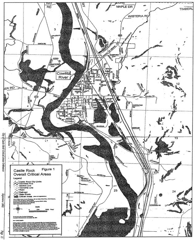
[Ord. 2002-03 Att. A, 2002].
Figure 2 Critical area – Wetland.
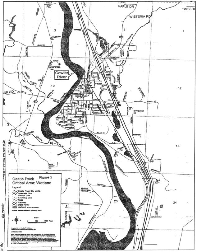
[Ord. 2002-03 Att. A, 2002].
Figure 3 Critical area – Special flood hazard area (SFHA).
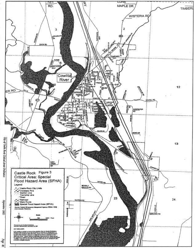
[Ord. 2002-03 Att. A, 2002].
Figure 4 Critical area – Severe soils.
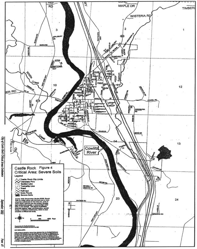
[Ord. 2002-03 Att. A, 2002].
Figure 5 Critical area – Steep slopes.
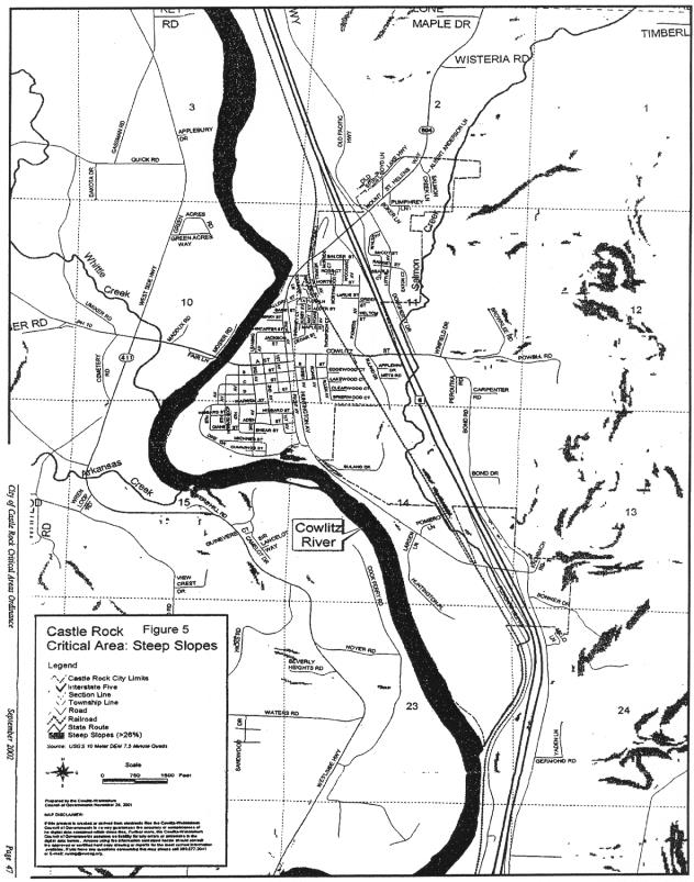
[Ord. 2002-03 Att. A, 2002].
Figure 6 Official zoning map.
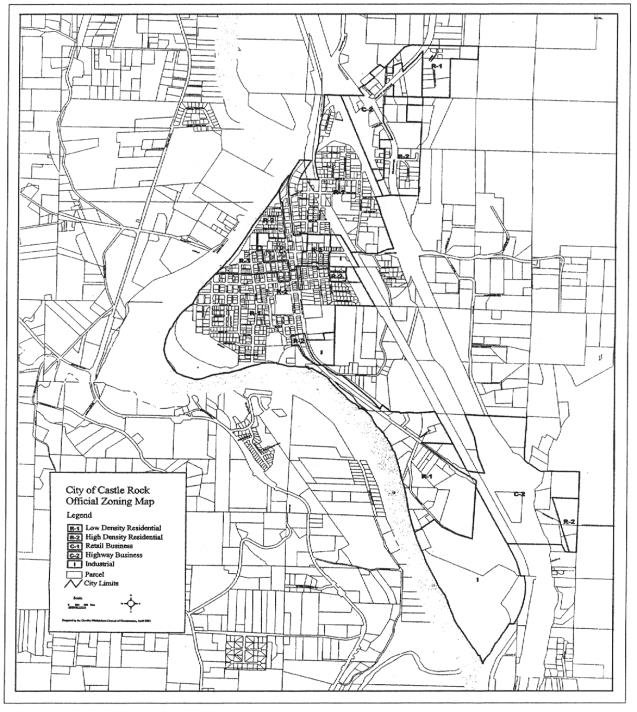
[Ord. 2002-03 Att. A, 2002].
The list in this subsection is illustrative of the bases for the decision of whether or not to grant the variance.