


Chapter 5 Watershed Basins
Chapters 3 and 4 describe Olympia's wastewater system in terms of system components: gravity sewer pipes, lift stations, STEP systems, grinder pump systems and septic systems, also known as onsite sewage systems (OSS). This chapter looks at the wastewater system from a basin perspective with an analysis of the unique characteristics and needs of each region of the Sewer Service Area.
In many cases, these characteristics and needs relate directly to the wastewater challenges discussed in Chapter 8.
Each regional wastewater basin is briefly described in terms of receiving waters, existing infrastructure, projected development, wastewater (also known as sewage) flow, number of STEP and OSS, water quality issues and specific challenges. Additionally, the maps in Appendix J show the location of gravity sewer pipes, lift stations and force mains (pressurized pipes), STEP force mains and tanks, and OSS within each basin.
The regional wastewater basins are delineated in Figure 5.1. Each basin shares a common sewer pipe at the downstream end of the basin. All of the wastewater in a basin flows to and through that pipe. Basins can be drawn very large such as the eastside of the city versus the westside. They can also be drawn very small, with a single street or neighborhood as a basin. These six regional basins were chosen because they share some common characteristics and form a basis for discussing the wastewater system as a whole. Each regional basin contains a unique mix of wastewater infrastructure. Table 5.1 summarizes the basin's wastewater characteristics.
|
Characteristics |
Central |
East |
Northeast |
Southeast |
Far West |
Near West |
|---|---|---|---|---|---|---|
|
OSS within 200' of sewer |
29 |
360 |
82 |
432 |
106 |
136 |
|
Total OSS |
48 |
1,306 |
228 |
1,930 |
488 |
282 |
|
STEP Systems |
23 |
370 |
34 |
1,220 |
118 |
34 |
|
Grinder Pumps |
12 |
41 |
28 |
63 |
86 |
59 |
|
Lift Stations (including City and LOTT owned) |
2 |
6 |
5 |
8 |
10 |
5 |
|
Percentage of basin served by combined sewer pipes |
56% |
8% |
16% |
3% |
0% |
0% |
|
Single-family Residential Customers |
899 |
2,321 |
1,847 |
3,280 |
3,025 |
2,539 |
|
Multi-family Residential Customers (# of apartments) |
73 (1,425) |
171 (1,843) |
34 (348) |
51 (494) |
329 (3,522) |
92 (1,380) |
|
Commercial Customers |
377 |
527 |
56 |
36 |
401 |
132 |
|
Total Sewer Customers |
1,349 |
3,019 |
1,937 |
3,367 |
3,755 |
2,763 |
|
% Basin Undeveloped |
5% |
14% |
9% |
15% |
11% |
12% |
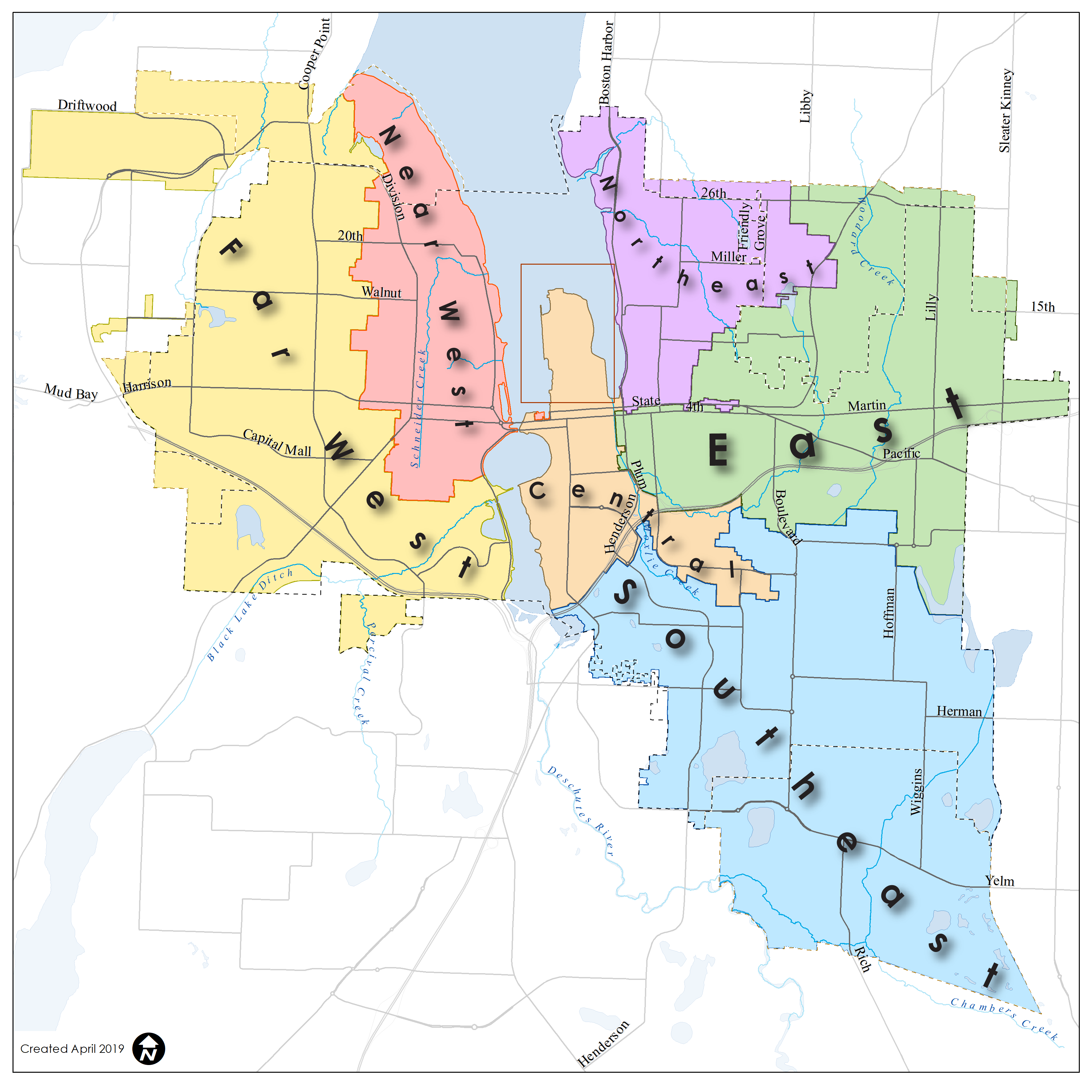
View Figure 5.1 Olympia's Regional Wastewater Basins
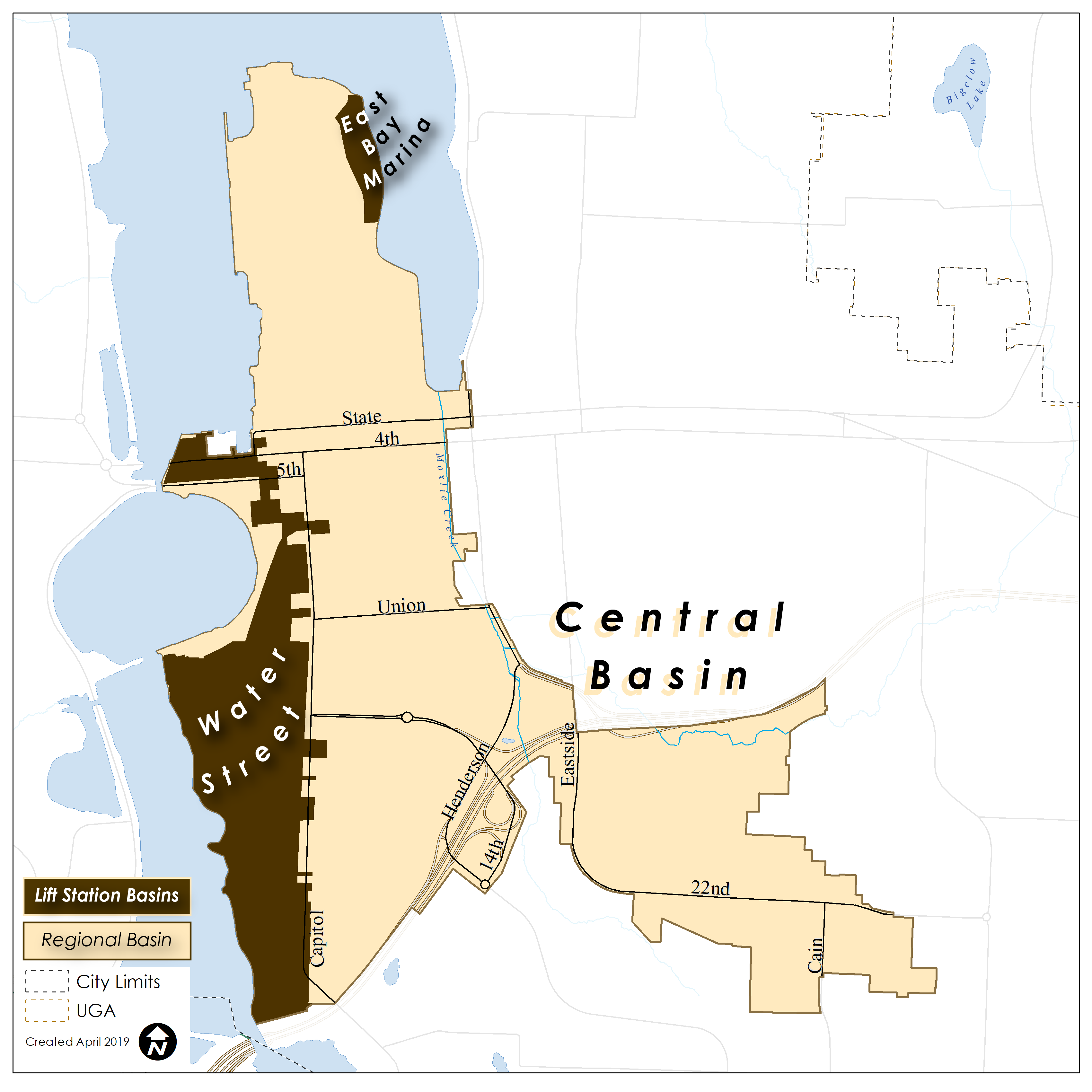
5.1 Central Basin
The Central basin (Figure 5.2) encompasses the older developed areas of Olympia. It is dominated by the central business district; the Ellis, Mission and Indian Creek watersheds on the east and south side; and that part of the near west side of the City and its Urban Growth Area (UGA) that drains to Capitol Lake or Budd Inlet. Population and business density in the basin is high.
The precipitation, surface water and ground water within the Central basin discharge to Budd Inlet. Most the City's water quality monitoring data focus on Budd Inlet and its tributary waters. Budd Inlet is the focus of extensive technical analysis and regulation.
Much of this basin is already developed (86%) with future development largely limited to redevelopment and small new developments. Wastewater flows are not expected to increase appreciably. The anticipated increase in peak wastewater flows is only one percent through 2025. Nearly all of this projected increase is expected to come from residential infill and commercial development/redevelopment. The existing wastewater system in the Central basin typically has adequate capacity and facilitates the connection of new development to sewer service.
The main challenge with the wastewater system in the Central basin is its age. Many pipes are well over 50 years in age and some are more than 100. With age, the pipes become susceptible to structural deterioration, collapse, and increased infiltration and exfiltration. Infiltration occurs when groundwater enters the sewer pipe through cracks. Similarly, wastewater can leave the pipe and enter soils and groundwater (exfiltration). Operation and maintenance needs in the basin are typically greater and more intricate than in other basins.
The Central basin also contains the City's highest percentage of combined wastewater/stormwater pipes. The combined system collects stormwater from streets and buildings and routes it to the LOTT Clean Water Alliance's Budd Inlet Treatment Plant through sewer pipes. Stormwater flows tax the capacity of otherwise adequately-sized sewer pipes. A number of areas are projected to have capacity issues in the event of a major rain event. These areas are addressed in Chapter 10.
Two lift stations, including the large Water Street station, are essential to the operation of the Central basin wastewater system. The service areas of the lift stations (LS) are delineated in Figure 5.2.
Given its evolution over time, the Central basin's wastewater system is complex and sometimes challenging to analyze. The management of these pipe systems focuses on refining Utility staff's understanding of the system and maintaining its integrity as it ages. Pipe maintenance and upgrades in this basin are costly.
The basin has only 23 STEP systems, 12 grinder pumps systems and 48 OSS, leaving the vast majority of the basin served by gravity sewer.
The complex, aging public infrastructure creates the potential for water quality impacts to Budd Inlet. State efforts through Clean Water Act water quality studies are underway to improve water quality in Budd Inlet. From a water quality perspective, the Central basin is carefully managed to prevent spills, correct unintentional cross connections with stormwater systems, and ensure the structural integrity of the pipes.
5.2 East Basin
The East basin (Figure 5.3) is located east of the Central basin. It includes some of the oldest residential neighborhoods in Olympia as well as the commercial corridor on both sides of Martin Way. Development pressure remains strong in this basin. New development in the basin will include subdivisions such as the Village at Mill Pond, infill, redevelopment, and some light commercial. The Lilly Road area also includes the Providence/St. Peters Hospital and Kaiser Permanente Medical Center, along with ancillary medical practices in the vicinity.
The East basin is partially within the Henderson Inlet Shellfish Protection Area, a water quality and shellfish harvesting priority. Precipitation and surface water split with the northern part draining to Woodard Creek and subsequently to Woodard Bay in Henderson Inlet while the southern part drains to Indian Creek and from there to Budd Inlet. Historical bacterial contamination in Henderson Inlet has declined and the shellfish beds are productive and commercially viable. Management of public and private wastewater systems is a key aspect of maintaining the Inlet's shellfish industry.
The wastewater system in the East Basin is comprised of a fragmented mix of gravity sewer pipes, lift stations, STEPs, grinder pumps, and OSS. The basin's inconsistent topography resulted in this mix of wastewater technologies. The basin has a large number of STEP systems (370), grinder pumps (41) and OSS (1,305) for its total area.
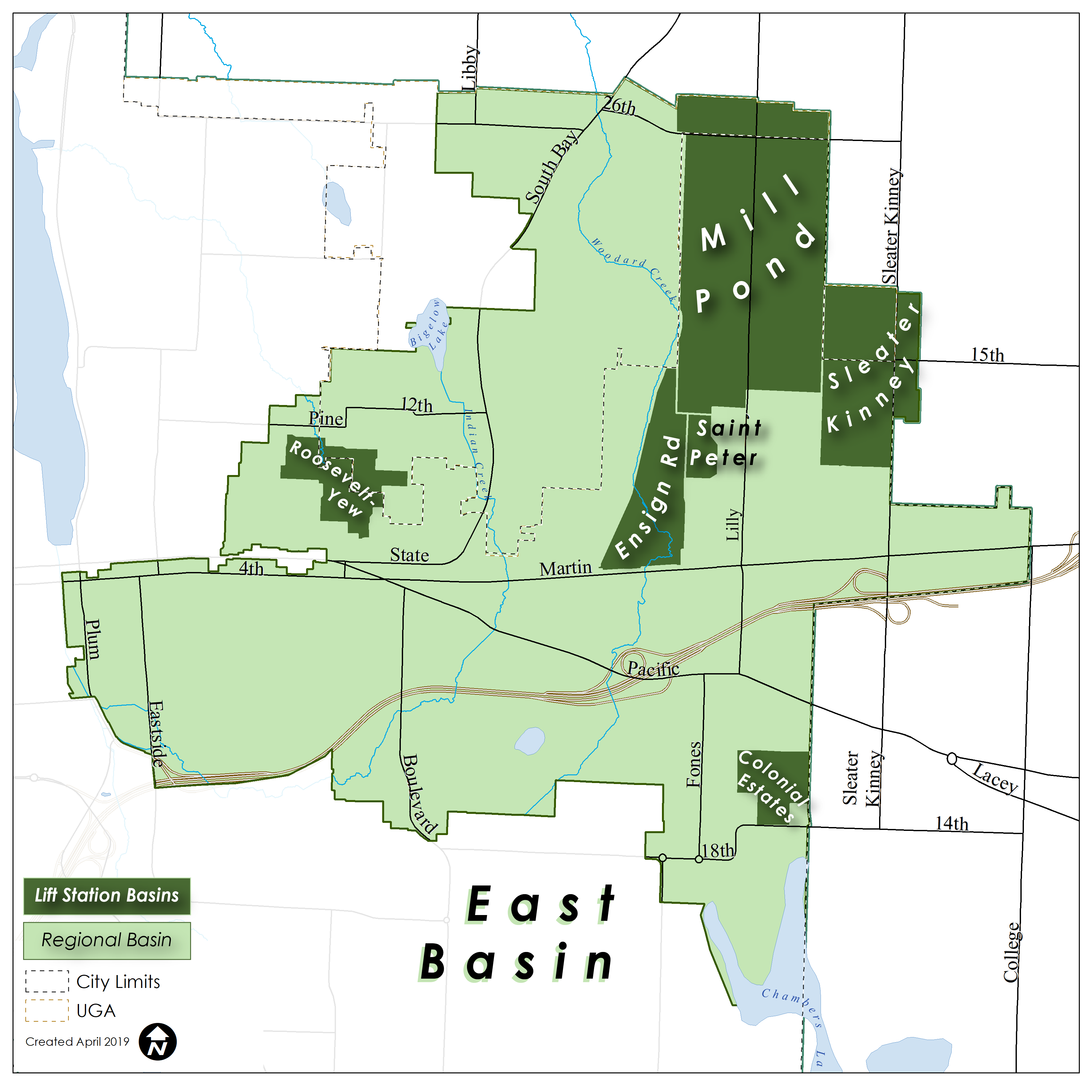
As development continues, the East basin may struggle to extend sewer infrastructure, especially in the South Bay Road area. See Appendix J for a map showing future lift station areas and major infrastructure. Successful water resource management will focus on connection of new development to sewer service as well the conversion of OSS.
5.3 Northeast Basin
The Northeast watershed basin (Figure 5.4) can be challenging from both wastewater and water resource management perspectives. Both topographical and development patterns make wastewater systems difficult to link into a regional system. Areas of relatively low development density and pockets of OSS hamper the orderly expansion of the wastewater system.
Precipitation and surface water drain to Budd Inlet through various creeks including Moxlie Creek.
Streams generally flow south to north. The main sewer pipes in the basin flow north to south, along East Bay Drive. Secondary sewer pipes and lift stations collect and transport wastewater into these main pipes. Flows subsequently travel west in the LOTT pipes. Sewer pipes in the basin range from older to contemporary.
This basin is projected to experience a lower rate of development over the next 25 years. Development becomes increasingly residential, and less dense, in the northern portions of the basin. Light commercial development is scattered throughout.
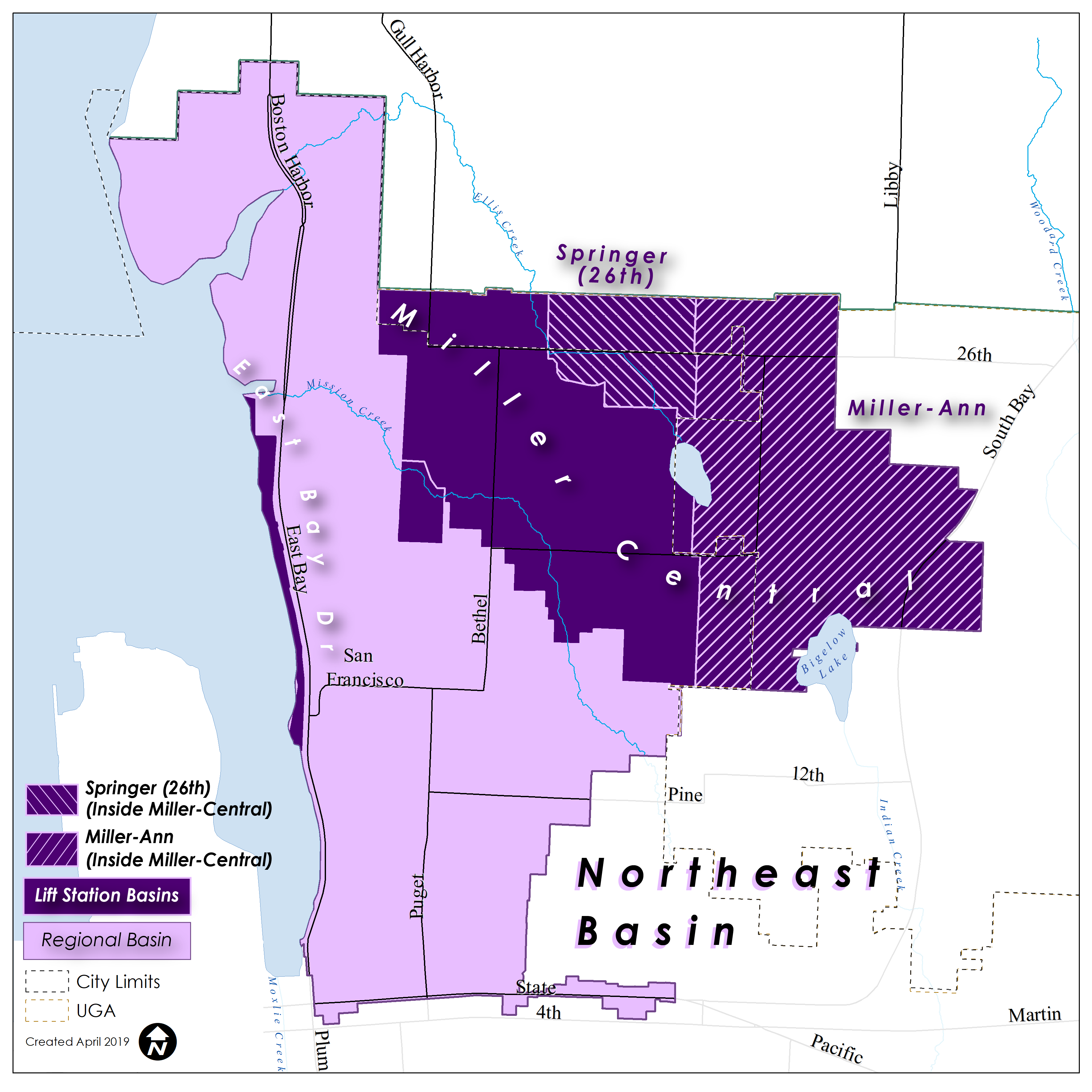
View Figure 5.4 Northeast Basin
The Northeast basin has 10 STEP systems, 28 grinder pump systems and 228 OSS. In general, the OSS are located more than 200 feet from an available sewer pipe. See Appendix J for a map showing future lift station areas and major infrastructure.
5.4 Southeast Basin
The Southeast basin (Figure 5.5) includes some of the initial residential neighborhoods that were developed as Olympia spread to the southeast in the 1950s - 1970s. Development pressure remains strong in this basin. New development will include subdivisions, infill, redevelopment and some light commercial. Peak flows in this basin are expected to increase more than other basins over the next 20 years. Planning for these flows is important to the orderly operation of the Wastewater Utility.
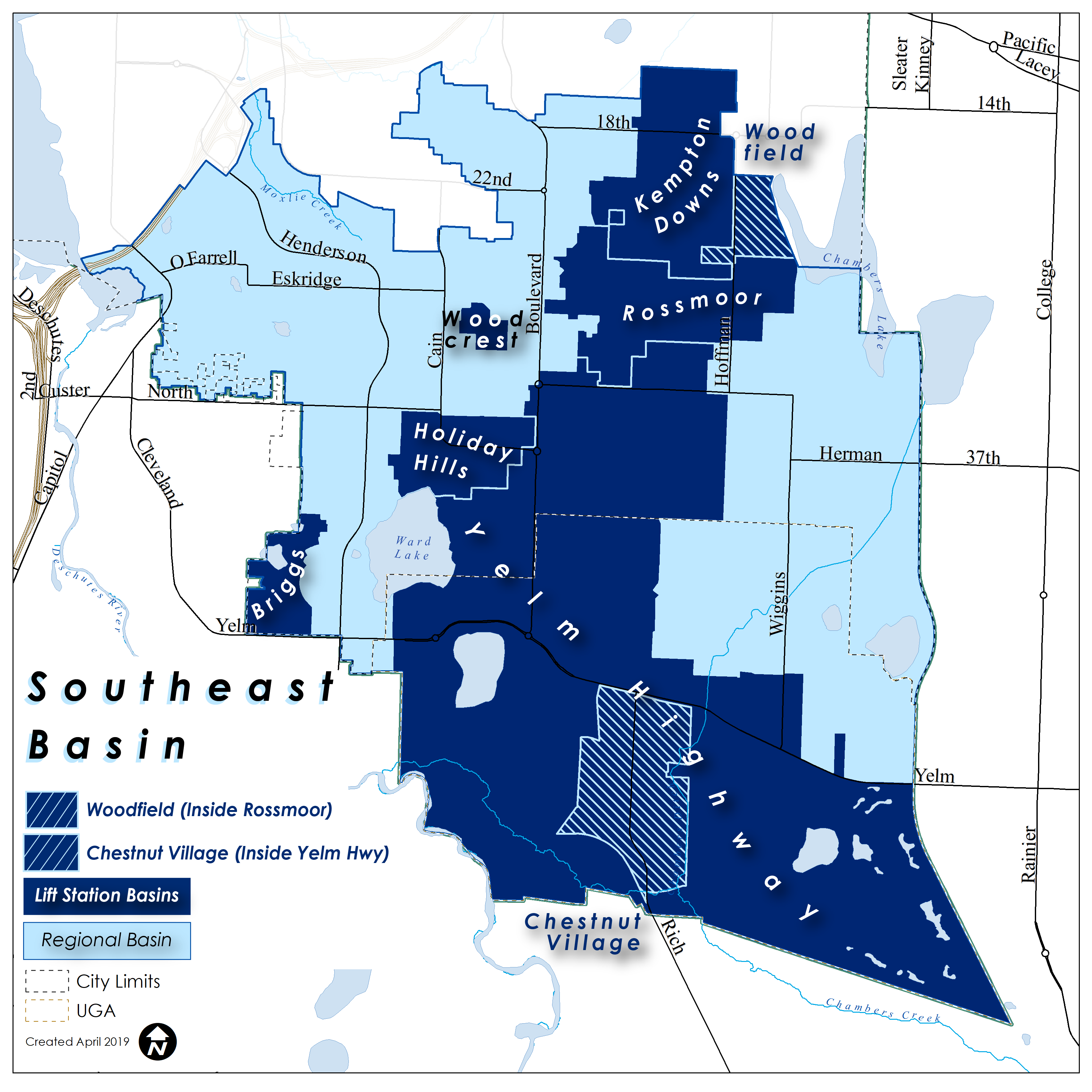
View Figure 5.5 Southeast Basin
This basin, characterized by its flat topography, has been the focus of considerable STEP system development since the mid-1990s. Additionally, many of the older residences in this basin are served by OSS. There are 1,220 STEP systems, 63 grinder pump systems and 1,930 OSS in the basin. OSS are typically distant from the gravity flow portion of the wastewater system.
Stormwater and surface water in the Southeast basin mainly discharge to the Deschutes River and ultimately Budd Inlet. Some of the storm and surface water drains to kettles such as Ward Lake and Hewitt Lake. Other water bodies include portions of Chambers Lake and Chambers Creek, which discharges into the Deschutes River. The river is a major contributor of flows and potential contaminants to Budd Inlet. The basin's topography requires several lift stations. Ongoing new development in the basin prompts the need for carefully managed sewer infrastructure extensions.
As development continues, the Southeast basin may struggle to extend sewer infrastructure, especially in the Chambers Prairie area. The area around Wiggins Road and south of Yelm Highway will need to be served by pumps, either through lift stations or individual pumps. See Appendix J for a map showing future lift station areas and major infrastructure.
5.5 Far West Basin
The Far West basin (Figure 5.6) includes newer neighborhoods of west Olympia, and much of the Westside commercial district. With both redevelopment and new development forecast for this basin, sewer flows in the basin will increase.
Surface water flows in the Far West basin discharge to Green Cove which is connected to Eld Inlet to the north. To the south, water flows to Black Lake Ditch, Percival Creek, Capital Lake, and finally Budd Inlet. The Percival Creek system is the City's largest stream and the most viable for salmon. Bacteria levels in the stream are typically low, potentially reflecting the extensive wastewater system and low number of OSS (489) in the basin. The relatively high water quality of Eld Inlet warrants continued protection as urban scale development extends to the west of Olympia. In order to help protect its aquatic resources, the City has enacted special zoning and development requirements for the Green Cove basin.
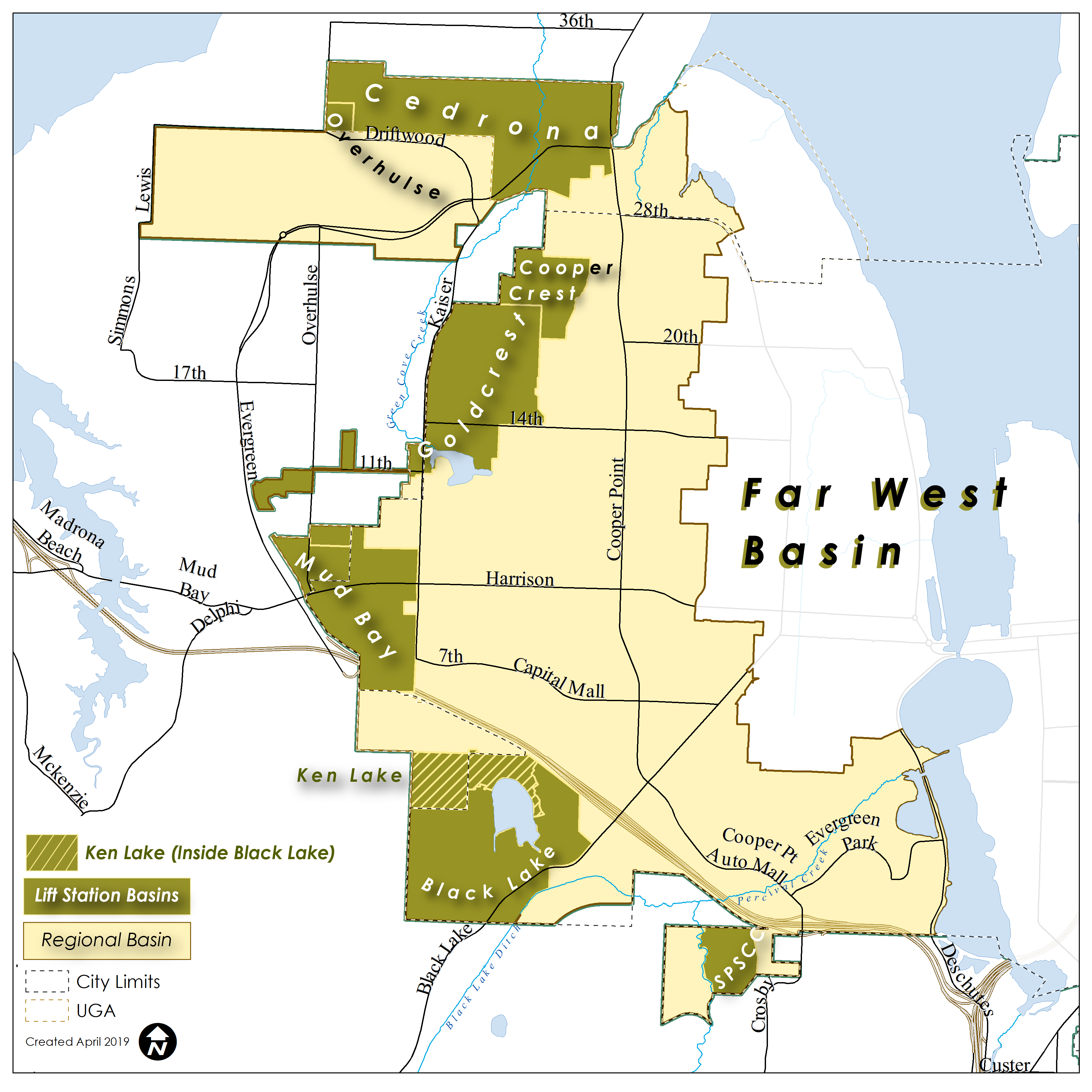
View Figure 5.6 Far West Basin
Older wastewater infrastructure dominates the residential neighborhoods of West Olympia. Conversely, the newer neighborhoods, commercial and multifamily areas are typically served by newer pipe systems including 118 STEP systems. The topography of the basin supports extensive use of gravity pipe systems as well as a number of lift stations. The wastewater system in the basin is generally able to accommodate growth.
Future wastewater management will focus on maintaining the older residential wastewater system and ensuring the orderly extension of new sewer infrastructure. Key challenges for this basin focus on providing sewer infrastructure extensions to the low-lying areas. See Appendix J for a map showing future lift station areas and major infrastructure.
5.6 Near West Basin
The Near West basin (Figure 5.7) is dominated by some of the oldest neighborhoods in the city. The surface and groundwater flows from the basin discharge to Schneider Creek, other smaller creeks and eventually Budd Inlet.
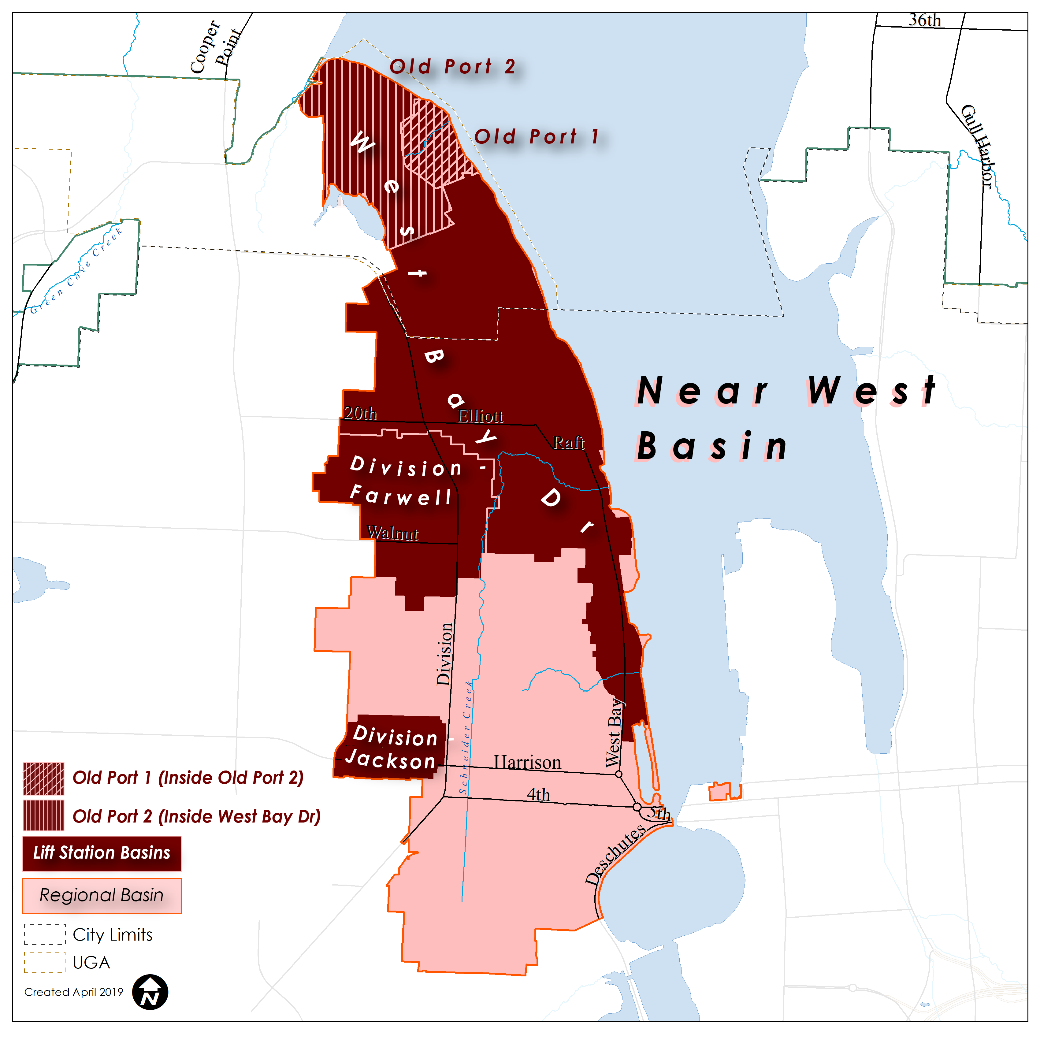
View Figure 5.7 Near West Basin
The basin includes 34 STEP systems, 59 grinder pump systems and 282 OSS, mainly located in the north half of the basin. Key challenges for this basin focus on management of older infrastructure and inflow and infiltration.
A few areas in this basin are projected to have capacity issues in the event of a major rain event. These areas are addressed in Chapter 10.