


Chapter 19.110
SPECIAL OVERLAY ZONES
Sections:
19.110.030 Airport hazard overlay.
19.110.040 Pipeline hazard overlay.
19.110.010 Medical Office Overlay.
Repealed by Ord. 16-018. (Ord. 07-015 § 4, 2007).
19.110.020 Spokane Valley Sprague and Appleway Corridors Subarea Plan.
Repealed by Ord. 11-010. (Ord. 09-028 § 1, 2009; Ord. 09-026 § 1, 2009; Ord. 09-021 § 2, 2009; Ord. 09-012 § 2, 2009; Ord. 07-015 § 4, 2007).
19.110.030 Airport hazard overlay.
A. Purpose and Intent. The purpose and intent of the Airport Hazard Overlay (AO) zone is to reduce the potential for airport hazards, because:
1. Airport hazards endanger the lives and property of users of landing fields and persons in the vicinity of Felts Field;
2. Airspace obstructions and incompatible land uses impair the utility of an airport and diminish the value of the public investment therein; and
3. Preventing the creation or establishment of incompatible land uses and airport hazards protects the public health, safety, and general welfare, and promotes the most appropriate use of land.
B. Applicability. The AO zone applies to areas surrounding Felts Field, as established herein. Chapter 19.110 SVMC shall apply to all lands, buildings, structures, natural features, and uses located within the AO zoning district as depicted on the maps, except that the provisions of Chapter 19.110 SVMC shall not apply to any use that is defined as an aviation use. All uses and activities are at all times subject to the underlying zoning district. Where the requirements and restrictions imposed by the AO zone conflict with the requirements of the underlying zoning district, the more restrictive requirement shall apply.
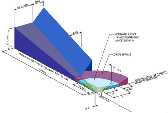
C. Air Hazard Height Restrictions. Except as otherwise provided herein, no building or structure shall be erected, altered, or maintained so as to project or otherwise penetrate the Federal Aviation Regulations Part 77 airspace surfaces shown on the Airport Hazard Map attached to the ordinance codified in SVMC 19.110.030 and made a part hereof for all purposes. Such applicable height limitations are hereby established for each of the zones as follows:
1. Primary Surface. A surface longitudinally centered on a runway. The primary surface extends 200 feet beyond each end of the runway and is 1,000 feet wide. The elevation of any point on the primary surface is the same as the elevation of the nearest point on the runway centerline.
2. Precision Instrument Runway Approach Zone. Slopes 50 feet outward for each foot upward beginning at the end of and at the same elevation as the primary surface and extending to a horizontal distance of 10,000 feet along the extended runway centerline; thence slopes upward 40 feet horizontally for each foot vertically to an additional horizontal distance of 40,000 feet along the extended runway centerline.
3. Transitional Zones. Slopes seven feet outward for each foot upward beginning at the sides of and at the same elevation as the primary surface and the approach surface, and extending to a height of 150 feet above the airport elevation which is 1,952 feet above mean sea level. In addition to the foregoing, there are established height limits sloping seven feet outward for each foot upward beginning at the sides of and at the same elevation as the approach surface and extending to where they intersect the conical surface. Where the precision instrument runway approach zone projects beyond the conical zone, there are established height limits sloping seven feet outward for each foot upward beginning at the sides of and at the same elevation as the approach surface, and extending a horizontal distance of 5,000 feet measured at 90-degree angles to the extended runway centerline.
4. Horizontal Zone. Established at 150 feet above the airport elevation or at a height of 2,102 feet above mean sea level.
5. Conical Zone. Slopes 20 feet outward for each foot upward beginning at the periphery of the horizontal zone and at 150 feet above the airport elevation and extending to a height of 350 feet above the airport elevation.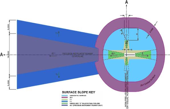
D. Height Exceptions. Structures shall not be constructed, altered, or maintained in the regulated air space area except as follows:
1. Any structure or object that would be shielded by existing structures of a permanent and substantial character or by natural terrain or topographic features of equal or greater height;
2. Any air navigation facility, airport visual approach or landing aid, aircraft arresting device, or meteorological device of a type approved by the FAA with a fixed location and height; and
3. Structures necessary and incidental to airport operations.
E. Airport Land Use Restrictions. The six airport land use compatibility zones established by the WSDOT Division of Aviation guidelines are based on federal aviation accident data from the National Transportation Safety Board (NTSB) and are shown on the airport land use compatibility zone map attached to the ordinance codified in SVMC 19.110.030 and made a part hereof for all purposes.
1. Prohibited Uses in All Airport Land Use Compatibility Zones.
a. Any use that creates or causes interference with the operations of radio or electronic facilities at the airport or with radio or electronic communications between airport and aircraft;
b. Any use or lighting that impairs a pilot’s ability to distinguish between airport lights and other lights, or that creates glare affecting pilot vision, or otherwise impairs visibility in the vicinity of the airport. All lighting shall be “cut-down” and fully shielded;
c. Any use that endangers the landing, taking off, or maneuvering of aircraft;
d. Any use which attracts birds in any manner affecting airport operations such as garbage, recycling, and stormwater facilities;
e. Special function land uses for which the significant common element is the relative inability of the people occupying the space to move out of harm’s way such as K – 12 schools, hospitals, nursing homes, and other similar uses;
f. High intensity land uses which are characterized by a potential to attract dense concentrations of persons to an indoor or outdoor area, even for a limited period of time. Such uses include:
i. Amusement parks and fairgrounds;
ii. Box retail;
iii. Convention/exhibit halls, major auditoriums, and theaters;
iv. Stadiums and arenas;
v. Temporary events attracting dense concentrations of people – fairs, circuses, carnivals, revival meetings, sports tournaments, conventions, but not including events for which exposure to aviation safety hazard is a well-known expectation (air shows, airport open houses, pilot meetings, etc.).
2. Land uses in airport land use compatibility zones are further regulated as follows:
|
Prohibited Uses |
Airport Land Use Compatibility Zones |
||||||
|---|---|---|---|---|---|---|---|
|
1 |
2 |
3 |
4 |
5 |
6a |
6b |
|
|
Single-Family Residential |
• |
• |
|
|
• |
|
|
|
Maximum Density ** |
n/a |
n/a |
1 du/5 acres |
1 du/2.5 acres |
n/a |
1 du/2.5 acres or underlying zone(1a)(2) |
1 du/2.5 acres or underlying zone(1a-c)(2) |
|
Manufactured Housing Parks |
• |
• |
• |
• |
• |
• |
• |
|
Multifamily Residential |
• |
• |
• |
• |
• |
• |
• |
|
Schools |
• |
• |
• |
• |
• |
• |
• |
|
Parks and Playgrounds |
• |
• |
• |
• |
• |
• |
• |
|
Hospitals |
• |
• |
• |
• |
• |
• |
• |
|
Nursing Homes |
• |
• |
• |
• |
• |
• |
• |
|
Day Care |
• |
• |
• |
• |
• |
• |
• |
|
Churches |
• |
• |
• |
• |
• |
• |
• |
|
Hazardous Materials Storage |
• |
• |
• |
• |
• |
|
|
|
Flammable Materials Storage |
• |
• |
• |
• |
• |
|
|
|
Incinerators |
• |
• |
• |
• |
• |
• |
• |
|
Overhead Utilities |
• |
• |
• |
• |
• |
• |
• |
|
High Intensity Uses |
• |
• |
• |
• |
• |
|
|
|
• Prohibited Uses |
|||||||
|
** Density Limited |
|||||||
|
(1) Must comply with a minimum of one of the following criteria: a. The site had water or sewer stubs installed for future development prior to the adoption of the City initial airport hazard overlay regulations on February 28, 2006, by Ordinance No. 06-002; b. Consistent with adjacent (not across public rights-of-way) property sizes for proposed development; or c. More than one residence is located on a property, excluding any residence used at one time for a dependent relative, may develop property consistent with underlying zoning to make conforming. (2) All final short subdivisions and final subdivisions located within Zone 6 of the AO shall contain the following dedication language on the face of the plat: “These lots are located in an Airport Hazard Overlay that may be subject to increased noise levels.” |
|||||||
3. Avigation easements/title notice/covenant shall be required as a condition of the issuance of any permit for construction, reconstruction, or expansion of any structure located within any airport land use compatibility zone.
Airport Land Use Compatibility Zones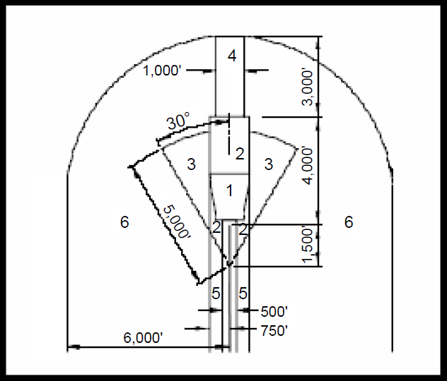
Source: California Airport Land Use Planning Handbook, California Department of Transportation Division of Aeronautics, recommended by Washington Department of Transportation, Aviation Division.
4. Substantial noise impacts (over 65 Ldn) at Felts Field are confined to airport property. In the event of changed conditions authenticated by the Spokane Airport Board, the following uses will be prohibited within areas where noise levels exceed 65 Ldn:
a. School.
b. Church.
c. Hospital.
d. Manufactured home park.
e. Child day care center.
f. Nursing home.
g. Parks and playgrounds.
5. Nothing in Chapter 19.110 SVMC shall diminish the responsibility of project proponents to submit a notice of construction or alteration to the FAA if required in accordance with Federal Aviation Regulations Part 77, “Objects Affecting Navigable Airspace.”
F. Nonconforming Uses.
1. Regulations Not Retroactive. The regulations prescribed herein shall not be construed to require the change of use, nor the removal or alteration of any structure or tree not conforming to the regulations as of the effective date of the ordinance codified in Chapter 19.110 SVMC; provided, however, that the owner of any existing nonconforming structure or tree is required to permit the installation, operation, and maintenance of such markers and lights as shall be deemed necessary by the director of airport operations.
2. Nonconforming Uses Abandoned or Destroyed. Whenever the city manager or designee determines that a legal nonconforming tree or structure has been abandoned, destroyed, or damaged by more than 80 percent, no permit shall be issued or granted that would allow such use, structure or tree to exceed the applicable height limit or otherwise deviate from the zoning regulations.
G. Permits and Variances.
1. No building permit shall be issued for any prohibited use, or for any structure or obstruction which exceeds the air hazard height restrictions adopted herein.
2. An application for a permit for the construction of a building, structure, use, subdivision, short subdivision, binding site plan, or other development located within the AO zone shall submit a site plan which includes the elevation of the site above mean sea level, and the height of any proposed structure.
3. Additional Notice. Any building permit or land use action including plats, short plats, subdivisions, and binding site plans within the AO zone shall contain the following notice:
Notice is herein provided that this property is located within the Airport Hazard Overlay Zone of the City of Spokane Valley, Washington, and is subject to restriction on height and use pursuant to SVMC 19.110.030 Airport Hazard Overlay Zone as it may be amended from time to time.
4. Variances. Any person desiring to erect or increase the height of any structure, or permit the growth of any tree, or use of property, not in accordance with the regulations prescribed herein may apply to the department for a variance; provided, however, that the application shall be accompanied by a determination from the FAA as to the effect of the proposal on the operation of air navigation facilities and the safe, efficient use of navigable airspace. A copy of the application shall be furnished to the director of airport operations for review and comment. Final determination on the variance shall be made by the hearing examiner following notice and hearing. (Ord. 17-004 § 3, 2017; Ord. 16-018 § 6 (Att. B), 2016).
19.110.040 Pipeline hazard overlay.
The following regulations shall only apply to the pipeline facilities identified on the zoning map:
A. The regulation of development, including construction, excavation or fill, or installation of roads and utilities is intended to ensure the health, safety, and welfare of citizens and the protection of private property.
B. Pipeline hazard areas shall extend 500 feet from the centerline of any existing or future pipeline, whether or not such pipeline is located within a recorded easement or is included in a “blanket” or “open” easement.
C. The construction, excavation, fill, or installation of underground utilities or drainage facilities within the area of pipeline hazard shall require consultation with the pipeline operator prior to the issuance of any permit. If applicable, the pipeline operator shall identify the location and depth of cover required to protect the pipeline.
D. No permanent or temporary accessory structures, retaining walls, patios, swimming pools, or on-site waste disposal systems shall be permitted within 25 feet of any pipeline.
E. No permanent or temporary structures designed for human habitation or occupancy shall be located within 50 feet of any pipeline.
F. Utility poles, guy wires, or anchors shall not be placed within 10 feet of the pipeline.
G. For new construction, the City may require the lowering or relocation of the pipeline as a condition of the issuance of any permit. (Ord. 16-018 § 6 (Att. B), 2016).