


Chapter 10.46
DEVELOPMENT STANDARD CHARTS
Sections:
10.46.020 Residential district development chart.
10.46.030 Mixed use district development chart.
10.46.040 Commercial district development chart.
10.46.050 Overlay district development chart.
10.46.060 Minimum lot area calculations.
10.46.070 Minimum lot width and depth calculations.
10.46.080 Setback measurements and exceptions.
10.46.090 Building height calculations, exceptions, and modifications.
10.46.100 Lot coverage calculations.
10.46.110 Density calculations and exceptions.
10.46.010 Purpose.
A development chart and exceptions define the buildable area within the established districts. Conditional uses and overlay districts may require additional or varying considerations. (Ord. 2019-35 § 5; Ord. 2016-22 § 1 (Exh. B); Ord. 2010-03 § 1 (Exh. A); Ord. 2007-34 § 2 (Exh. A))
10.46.020 Residential district development chart.
(1) General Dimensional Standards. See WCC 10.46.060 through 10.46.110 for measurement methods and Chapter 10.47 WCC for more specific standards with respect to specific residence types. Where these standards conflict with Chapter 10.47 WCC, the city shall determine which requirement applies. Note that the column indicating conditions/exceptions/references is not all-inclusive. There may be other conditions in WCC.
|
Standard |
RS |
RL |
RM |
RH |
RF |
Conditions/ |
|
|---|---|---|---|---|---|---|---|
|
Minimum Lot Dimensions |
|||||||
|
Lot Area |
7,250 sf, except 10,000 sf for a duplex |
5,500 sf, except 8,000 sf for a duplex |
3,000 sf, except 4,500 sf for a duplex |
3,000 sf, except 4,000 sf for a duplex |
10,000 sf, except 15,000 sf for a duplex |
WCC 10.46.060 |
|
|
|
Cluster subdivision lot |
4,000 sf |
3,000 sf |
N/A |
N/A |
7,250 sf |
WCC 10.47.060 |
|
Lot Width |
70 feet |
50 feet |
30 feet |
30 feet |
100 feet |
WCC 10.46.070 |
|
|
|
Lot width alley access |
50 feet |
30 feet |
25 feet |
25 feet |
100 feet |
|
|
|
Lot width at point of access |
20 feet |
20 feet |
20 feet |
20 feet |
20 feet |
WCC 10.46.070(3) |
|
|
Cluster subdivision lot |
40 feet |
30 feet |
N/A |
N/A |
70 feet |
WCC 10.47.060 |
|
Lot Depth |
100 feet |
80 feet |
65 feet |
60 feet |
100 feet |
WCC 10.46.070 |
|
|
|
Cluster subdivision lot |
70 feet |
60 feet |
N/A |
N/A |
100 feet |
WCC 10.47.060 |
|
Setback Standards (WCC 10.46.080) |
|||||||
|
Street – Minimum |
20 feet(X)(Y) |
20 feet(X)(Y) |
15 feet |
10 feet |
25 feet |
WCC 10.46.080(2) (X) 15 feet from private lanes (Y) 15 feet for cluster subdivisions |
|
|
Street side – Minimum |
10 feet |
10 feet |
10 feet |
10 feet |
20 feet |
WCC 10.46.080(2)(a)(ii) |
|
|
Street – Minimum, individual garage, carport |
20 feet |
25 feet |
WCC 10.46.080(2)(b) |
||||
|
Rear – Minimum |
20 feet(W)(X) |
20 feet(W)(X) |
15 feet(X) |
10 feet(Y)(Z) |
20 feet |
WCC 10.46.080(3) (W) 15 feet for cluster subdivisions (X) 10 feet if adjacent to an alley (Y) 15 feet for ground related dwelling units (Z) WCC 10.46.090(2)(c) |
|
|
Side – Minimum |
5 feet |
5 feet |
5 feet |
6 feet |
10 feet |
WCC 10.46.080(4) |
|
|
Internal – Minimum |
10 feet |
10 feet |
10 feet |
10 feet |
N/A |
WCC 10.46.080(5) |
|
|
Building and Density Standards |
|||||||
|
Maximum Building Height |
30 feet |
30 feet |
35 feet |
60 feet(X)(Y) |
30 feet |
WCC 10.46.090 (X) WCC 10.46.090(2)(b) (Y) WCC 10.46.090(2)(c) |
|
|
Maximum Lot Coverage |
40% |
45% |
55% |
55% |
35% |
WCC 10.46.100 |
|
|
|
Duplexes, townhouses and multifamily |
50% |
55% |
55% |
55%(X) |
N/A |
(X) WCC 10.46.100(2)(a) |
|
|
Cluster lots |
55% |
55% |
N/A |
N/A |
45% |
|
|
Maximum Density |
6 dwelling units per acre |
8 dwelling units per acre |
20 dwelling units per acre |
40 dwelling units per acre |
4 dwelling units per acre |
WCC 10.46.110 |
|
(Ord. 2021-38 § 3 (Exh. A); Ord. 2020-35 § 3 (Exh. A); Ord. 2019-35 § 5; Ord. 2016-22 § 1 (Exh. B); Ord. 2010-25 § 4; Ord. 2010-03 § 1 (Exh. A); Ord. 2007-34 § 2 (Exh. A))
10.46.030 Mixed use district development chart.
(1) General Dimensional Standards.
|
Standard |
OMU |
WMU |
RMU |
Conditions/ |
|
|---|---|---|---|---|---|
|
Minimum Lot Dimensions |
|||||
|
Minimum lot area |
3,000 sf |
None |
5,000 sf |
WCC 10.46.060 |
|
|
Lot width |
40 feet |
None |
40 feet |
WCC 10.46.070 |
|
|
|
Lot with alley access |
30 feet |
None |
30 feet |
|
|
|
Lot width at point of access |
20 feet |
None |
20 feet |
WCC 10.46.070(3) |
|
Lot depth |
80 feet |
None |
80 feet |
WCC 10.46.070 |
|
|
Minimum Setbacks (WCC 10.46.080) |
|||||
|
Street |
10 feet |
None |
10 feet, except 25 feet for frontage on Orondo Ave. |
WCC 10.46.080(2) |
|
|
Street, individual garage, carport |
20 feet |
20 feet |
20 feet |
||
|
Rear |
10 feet(X) |
None(X) |
10 feet(X) |
WCC 10.46.080(3) and 10.46.080(3)(f) (X) WCC 10.46.090(2)(c) |
|
|
Side |
5 feet(X)(Y) |
None(Y) |
5 feet(Y) |
WCC 10.46.080(4) (X) WCC 10.46.080(4)(d) (Y) WCC 10.46.090(2)(c) |
|
|
Building and Density Standards |
|||||
|
Maximum building height |
60 feet(Y) |
90 feet(X)(Y) |
60 feet(Y) |
WCC 10.46.090 (X) 60 feet between First and Kittitas Streets (Y) WCC 10.46.090(2)(c) |
|
|
Maximum lot coverage |
50%(X) |
100% |
35%(X) |
WCC 10.46.100 (X) WCC 10.46.100(2) |
|
(Ord. 2020-35 § 3 (Exh. A); Ord. 2019-35 § 5; Ord. 2016-22 § 1 (Exh. B); Ord. 2010-03 § 1 (Exh. A); Ord. 2007-34 § 2 (Exh. A))
10.46.040 Commercial district development chart.
(1) General Dimensional Standards.
|
Standard |
CN |
CD |
CBD |
NWBD and SWBD |
I |
Conditions/Exceptions/Reference |
|
|---|---|---|---|---|---|---|---|
|
Minimum Lot Dimensions |
|||||||
|
Lot area |
10,000 sf |
None |
None |
None |
None |
WCC 10.46.060 |
|
|
Lot width |
60 feet |
None |
None |
None |
40 feet |
WCC 10.46.070 |
|
|
|
Lot with alley access |
40 feet |
None |
None |
None |
40 feet |
|
|
|
Lot width at point of access |
20 feet |
None |
None |
None |
None |
WCC 10.46.070(3) |
|
Lot depth |
100 feet |
None |
None |
80 feet |
80 feet |
|
|
|
Setback Standards (WCC 10.46.080) |
|||||||
|
Street – Minimum |
0 – 10 feet(X) |
15 feet |
0 – 10 feet(X) |
0 – 10 feet(X) |
0 feet |
WCC 10.46.080(2) (X) WCC 10.46.080(2)(d) |
|
|
Minimum sidewalk widths |
10 feet |
10 feet |
10 feet |
10 feet |
None |
WCC 10.46.080(2)(d)(i) and (iv) |
|
|
Street – Minimum, individual garage, carport |
20 feet |
20 feet |
None |
20 feet |
None |
WCC 10.46.080(2)(b) and (2)(d) |
|
|
Rear – Minimum |
0 feet(X) |
10 feet |
0 feet(Y) |
0 feet(X)(Y) |
0 feet(Y) |
WCC 10.46.080(3) (X) WCC 10.46.080(3)(f) (Y) WCC 10.46.090(2)(c) |
|
|
Side – Minimum |
5 feet |
10 feet |
0 feet(X)(Y) |
0 feet(X)(Y) |
0 feet(X)(Y) |
WCC 10.46.080(4) (X) WCC 10.46.080(4)(e) and (f) |
|
|
Building Standards |
|||||||
|
Maximum building height |
35 feet |
60 feet(Y) |
90 feet(X) |
90 feet(X) |
90 feet(X) |
WCC 10.46.090 (X) WCC 10.46.090(2)(c) (Y) WCC 10.46.090(2)(d) |
|
|
Maximum lot coverage |
50% (X) |
100% |
100% |
100% |
70% |
WCC 10.46.100 (X) WCC 10.46.100(2) |
|
(Ord. 2023-25 § 3 (Exh. A); Ord. 2022-33 § 3 (Exh. A); Ord. 2020-35 § 3 (Exh. A); Ord. 2019-35 § 5; Ord. 2016-22 § 1 (Exh. B); Ord. 2014-10 § 1 (Exh. B); Ord. 2010-03 § 1 (Exh. A); Ord. 2007-34 § 2 (Exh. A))
10.46.050 Overlay district development chart.
(1) General Dimensional Standards. If additional development standards apply, they are listed in Chapter 10.40 WCC.
|
Standard |
MRC |
WMU-RRO |
WMU-PO |
Conditions/ |
|---|---|---|---|---|
|
Minimum Lot Dimensions |
||||
|
Lot Area |
Same as underlying zoning district |
Same as underlying zoning district |
Same as underlying zoning district |
WCC 10.46.060 |
|
Lot Width |
Same as underlying zoning district |
None |
None |
WCC 10.46.070 |
|
Lot Width at Point of Access |
Same as underlying zoning district |
Same as underlying zoning district |
Same as underlying zoning district |
|
|
Lot Depth |
Same as underlying zoning district |
None |
None |
WCC 10.46.070 |
|
Setbacks (WCC 10.46.080) |
||||
|
Street |
15 feet |
Same as underlying zoning district |
Same as underlying zoning district |
WCC 10.46.080(2) |
|
Rear |
10 feet |
Same as underlying zoning district |
Same as underlying zoning district |
WCC 10.46.080(3) |
|
Side |
5 feet |
Same as underlying zoning district |
Same as underlying zoning district |
WCC 10.46.080(4) |
|
Building Standards |
||||
|
Maximum Building Height |
Same as underlying zoning district(X) |
60 feet |
90 feet(Y) |
WCC 10.46.090 (X) WCC 10.46.090(2)(c) (Y) 60 feet between First and Kittitas Streets |
|
Maximum Lot Coverage |
55% |
Same as underlying zoning district |
Same as underlying zoning district |
WCC 10.46.100 |
(2) Grandview Historic District Overlay. Standards applicable to the setbacks of primary structures in the Grandview historic district overlay as detailed in the Grandview Historic District Preservation Handbook, adopted by reference pursuant to WCC 10.40.060, supersede those development standards of the underlying zoning district. Accessory structures shall comply with the underlying zoning district standards. (Ord. 2020-35 § 3 (Exh. A); Ord. 2019-35 § 5; Ord. 2016-22 § 1 (Exh. B); Ord. 2013-09 § 3; Ord. 2010-03 § 1 (Exh. A); Ord. 2007-34 § 2 (Exh. A))
10.46.060 Minimum lot area calculations.
Minimum lot area calculations are based on the total land area contained within the boundary lines of any lot, tract or parcel of land, exclusive of public rights-of-way and private lanes in a tract, and may be expressed in square feet (sf) or acres. (Ord. 2019-35 § 5)
10.46.070 Minimum lot width and depth calculations.
(1) For generally rectangular-shaped lots:
(a) Minimum lot width is measured at the building line or at the street lot line. For corner lots, minimum lot width is measured at the street lot line with the least street frontage.
(b) Minimum lot depth is measured between the midpoints of straight lines connecting the two street property corners and the two rear property corners.
(2) For non-rectangular-shaped lots, the minimum lot width circle applies to help ensure that there is a minimum buildable area included in each lot created consistent with the intent for each zoning district.
(a) The minimum lot width circle establishes that at least some portion of a lot shall be at least as wide as the minimum lot width. The lot width circle shall not include streams, wetlands, or their associated buffers as designated in Chapter 12.08 WCC.
(b) Lots created through unit lot subdivision are exempt from the minimum lot width circle standards.
(3) Lot Width at Point of Vehicular Access. The lot width at point of vehicular access is the horizontal linear distance a lot, or a portion of a lot, adjoins a public or private street or easement and is used to comply with WCC 11.20.050(1).
Figure 10.46.070
Clarifying minimum lot depth and width provisions, including the minimum lot width circle requirement for irregularly shaped lots.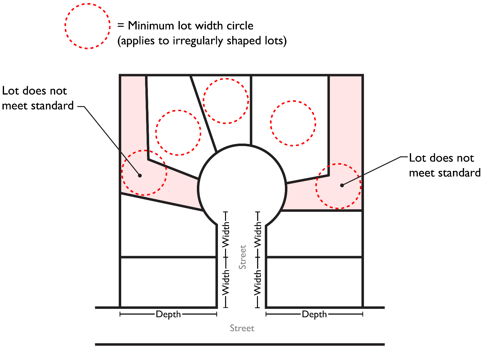
(Ord. 2020-35 § 3 (Exh. A); Ord. 2019-35 § 5)
10.46.075 Lot line angles.
(1) The shape of lots shall be generally rectangular in shape and minimize the number of angles.
(2) Side lot lines shall be straight lines running within 20 degrees of perpendicular to the road upon which the lots front for a minimum distance equal to half the required lot depth. Side lot lines on curved roads should run at or near radially to the curve.
(3) Flag lots shall be avoided whenever possible, except on the outside radius of a curved street, where side lot lines should run at or near radially to the curve not to exceed half the minimum lot depth.
(4) For the purpose of promoting good lot design which facilitates site planning for home placement, open space, infrastructure, or addressing existing site constraints, the director may grant limited exceptions to these rules. (Ord. 2020-35 § 3 (Exh. A); Ord. 2019-35 § 5)
10.46.080 Setback measurements and exceptions.
The development charts in this chapter provide minimum standards for street, side, rear, and interior setbacks. Figure 10.46.080 shows the location of some setback types on a typical lot. Clarification on how these setbacks are measured is provided in subsections (1) through (9) of this section.
Figure 10.46.080
Setback types.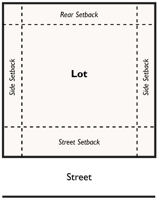
(1) Measurement. All setbacks shall be measured at right angles, or as near to right angles as possible, to the nearest property line (unless where otherwise noted) in a plane horizontal to the ground. Setback directions and exceptions shall be determined as provided in subsections (2) through (9) of this section.
(2) Street Setbacks. The street setback is measured from the street right-of-way unless otherwise noted.
(a) Street Setback Clarifications/Exceptions in All Applicable Zones.
(i) Street setbacks may be expanded in accordance with WCC 10.48.130 (Fences and clear view triangle).
(ii) For corner lots in residential zones, the street setback is measured from the street right-of-way that includes the property’s vehicle driveway. The other lot frontage is referred to as the street side setback. On corner lots accessed via an alley, the property owner shall designate the street and street side setbacks.
(iii) Roofed porches and covered entries may project a maximum of eight feet into the required street setback, provided such projections remain unenclosed, except for partial walls or guard rails that measure less than 42 inches from the floor of the porch.
(iv) Eaves, cornices, awnings or other architectural projections may project a maximum of four feet into required street setback (except for those elements described in subsection (2)(a)(iii) of this section).
(v) Bus amenities may be located within the street setback in accordance with WCC 10.48.120 and as agreed by the developer, transit authority, and the city.
(vi) Additional setbacks may be required for lots adjacent to rights-of-way with planned improvements. Minimum distance from the centerline of the right-of-way equal to one-half of the required public right-of-way based on the public road classification, and for private roads, one-half of the required easement.
(vii) Street setbacks are applicable to both public streets and private lanes except as may otherwise be provided in city code.
(b) Street – Garage and Carport Setback Standards in All Zones. Street setbacks for individual garages and carports apply to the front doors of individual private garages or the front projection of a carport and do not apply to underground or above-ground parking structures shared by tenants of multifamily developments.
(c) Street Setback Clarifications/Exceptions in Residential Zones.
(i) A lot in a residential district joined on one or both sides by lots on which structures are set back less than the district minimum may observe a required street setback equal to the average of the adjacent structures or the average of the district minimum and an adjoining structure.
(ii) When the garage in the RF, RS or RL district is oriented to the side or located at or behind the required street setback, the front of the residence may extend five feet into the street setback. This exception shall not permit the front of a residence to be less than 15 feet from the public or private street.
(iii) Upper floor decks constructed over driveways may project a maximum of eight feet into the required street setback in the RF, RS, and RL zones and up to three feet in the RM zone, provided such projections remain unenclosed, except for required guard rails.
Figure 10.46.080(2)(a)
Permitted street setback projections.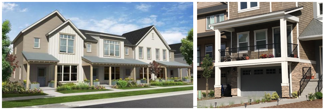
Roof porches/covered entries (left image) may project a maximum of eight feet into the required street setback. Upper level decks placed over driveways (right image) may project up to eight feet into the required street setback in the RF, RS, and RL zones and up to three feet in the RM zone.
(d) Street Setback Clarifications in Mixed Use and Commercial Zones.
(i) Minimum street setbacks shall accommodate minimum sidewalk widths per district, street, or block when specified. In the CBD zone, second floor spaces may extend over sidewalk to the right-of-way line.
(ii) Ten-foot minimum street setbacks are required for ground floor residential uses. Exceptions:
(A) Live-work residences provided they meet the provisions of subsection (2)(d)(iii) of this section.
(B) The street setback may be reduced to a minimum of five feet in the CBD, NWBD, SWBD, and WMU zones where the development conforms to Residential Design Guideline C.1.1 (Ground related units facing streets, common pathways or common open spaces).
(iii) Designated pedestrian-oriented streets per Figure C.1.d in the Residential Design Guidelines are subject to setback and facade standards in Residential Design Guidelines C.1 and E.4.
(iv) The minimum sidewalk width for the South Wenatchee business district south of Terminal Avenue is five feet.
(3) Rear Setbacks.
(a) Roofed porches may project a maximum of four feet into the required rear setback, provided the porch structure remains unenclosed, except for partial walls or guard rails that measure less than 42 inches from the floor of the porch.
(b) Decks and steps that are no taller than 48 inches above grade may project into the required rear setback.
(c) Eaves, cornices, awnings or other architectural projections may project a maximum of four feet into required rear setback.
(d) Accessory structures may observe a five-foot setback in the rear setback provided:
(i) The structure is not greater than 20 feet in height.
(ii) No projections (eaves, etc.) are within three feet of a property line.
(iii) No combination of structures extends more than 50 percent of the horizontal distance of the rear property line.
(e) Residential accessory structures may observe a zero setback where the rear property line is adjacent to an alley (except a minimum setback of five feet is required where a garage door faces the alley), provided the structure covers less than 50 percent of the rear property line and is no greater than 20 feet in height.
(f) In the OMU, RMU, CN, NWBD and SWBD zones where the rear setback abuts a residential zone, the minimum rear setback shall be the same as the minimum rear setback of the abutting zone.
(g) Only one rear setback is required. On corner lots that are generally rectangular in shape, an applicant may choose between the two property lines that are not adjacent to a street as to which will be used to measure the rear and side setbacks provided all existing and proposed structures comply with the applicable setback standards.
(h) Buildings, or portions thereof, containing dwelling units whose only solar access (windows) is from the applicable rear of the building (facing towards the rear property line) must be set back from the applicable rear property lines at least 15 feet. See Figure 10.46.080(3)(h).
(h).161124.png)
Figure 10.46.080(3)(h). Light/air access and privacy standards for structures containing dwelling units along side and rear property lines. Note that the minimum setbacks noted above only apply to buildings (and portions thereof) featuring the stated characteristics.
(4) Side Setbacks.
(a) Eaves, cornices, awnings or other architectural projections may project two feet into required side setback.
(b) Accessory structures may observe a five-foot setback in the side setback; provided, that no projections (eaves, etc.) are allowed within three feet of a property line and that no combination of structures extends more than 50 percent of the horizontal distance of the side property line.
(c) Residential accessory structures may observe a zero setback where the side property line is adjacent to an alley (except a minimum setback of five feet is required where a garage door faces the alley), provided the structure covers less than 50 percent of the side property line and is no greater than 20 feet in height.
(d) In the OMU zone, when abutting the RS, RL, or RM zone, the minimum setback shall increase by one foot for every two feet of additional building height over 20 feet.
(e) In the CBD, NWBD, SWBD, and I zones where the side setback abuts a residential zone, the minimum side setback shall be the same as the minimum side setback of the abutting zone.
(f) In the CBD, NWBD, SWBD, and I zones where the side setback abuts a residential zone, the minimum setback shall be increased by one foot for each one foot the proposed structure exceeds the maximum height of the abutting residential zone.
(g) Buildings, or portions thereof, containing dwelling units whose only solar access (windows) is from a building facade facing towards a side property line must be set back from the applicable side property lines at least 15 feet. See Figure 10.46.080(3)(h).
(5) Interior setbacks refer to the minimum distance between detached dwelling units (where allowed).
(6) Setbacks for Lots Served by a Shared Driveway. Lots that do not abut a public street but are served by a shared driveway are exempt from street setback requirements. Such lots shall have a rear lot line designated, typically opposite from the shared driveway, and all other lot lines are considered side lot lines (see Figure 10.46.080(6)).
Figure 10.46.080(6)
Clarification of setbacks shared driveway (single-family courtyard) and through lots.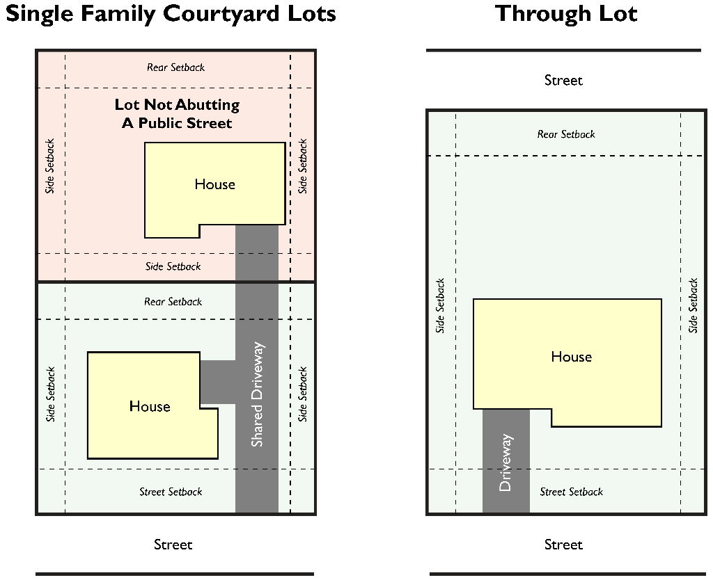
(7) Setbacks for Single-Family Courtyard. See WCC 10.47.070(2)(c) for applicable standards and examples.
(8) Through Lots. For lots featuring frontage on more than one public or private street, the street setback is measured from the street right-of-way that is the property’s street address and primary access. The opposite lot frontage is considered the rear setback. See Figure 10.46.080(6) for an example.
(9) Setback Measurements for Irregular Lots. Setback distances established for residential zones are based on rectangular lots. Nonrectangular lots, lots with three sides or more than four sides, curved property lines, and other nonstandard lots require special measurement techniques in order to achieve the purpose of setback requirements.
(a) Rear Setbacks. In the case of an irregularly shaped lot, a 10-foot line which is within the lot and parallel to and most distant from the street lot line shall be considered the rear lot line for purposes of determining required setbacks and for interpretation of other provisions of this code (see Figure 10.46.080(9)).
(b) Side Setbacks. All lot lines which are not street or rear lot lines shall be considered interior side lot lines for the purpose of measuring setbacks.
(c) Determination by the City. Where a building site is situated such that it is unclear which should be considered the street, rear, and sides, Required setbacks shall be as determined by the director in compliance with the following criterion: required setbacks shall not permit the placement of buildings on the site in a manner that will constitute a grant of special privileges inconsistent with the limitations placed on other properties in the vicinity and incompatible with surrounding uses.
Figure 10.46.080(9)
Examples of determining setback lines on irregular lots.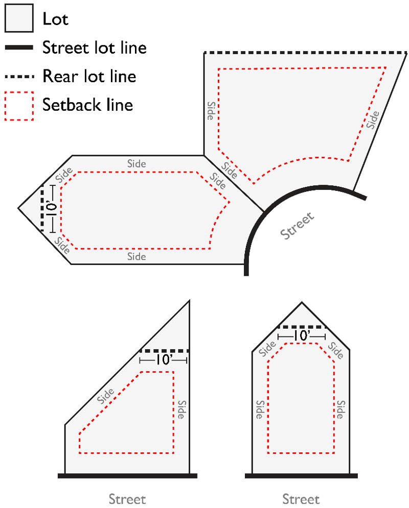
(Ord. 2023-25 § 3 (Exh. A); Ord. 2021-38 § 3 (Exh. A); Ord. 2020-35 § 3 (Exh. A); Ord. 2019-35 § 5)
10.46.090 Building height calculations, exceptions, and modifications.
(1) Building Height Calculations.
(a) Building height, except where otherwise noted, is measured to the highest point of a flat roof or the mean height between the eaves and ridge of a pitched roof from the average elevation of the proposed finished grade adjacent, within two feet, to the building foundation.
(b) On sites where the slope within the proposed building footprint exceeds 15 percent, no building shall have a nonaveraged height measured from the finished grade to the highest point of the building on any downslope facade(s) as to exceed the underlying maximum height by an extent equal to or greater than 15 percent (as shown in Figure 10.46.090(1)(b)).
Figure 10.46.090(1)(b)
Measuring building height on sloping sites (>15%).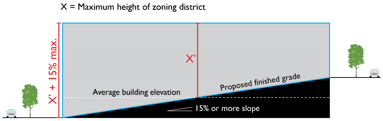
(c) As an alternative to the provision in subsection (1)(b) of this section on sites with slopes of 25 percent or greater, downslope building elevations must not exceed the maximum height of the zone, except for parapets as set forth in subsection (3)(b)(ii) of this section. Upper level building stepbacks at least 10 feet deep may be used to achieve maximum possible building height, as shown in Figure 10.46.090(1)(c) based upon the calculations in subsection (1)(a) of this section. The stepback must occur no lower than 50 percent of the maximum building height.
Figure 10.46.090(1)(c)
Alternative approach to measuring building height on sloping sites (>25%).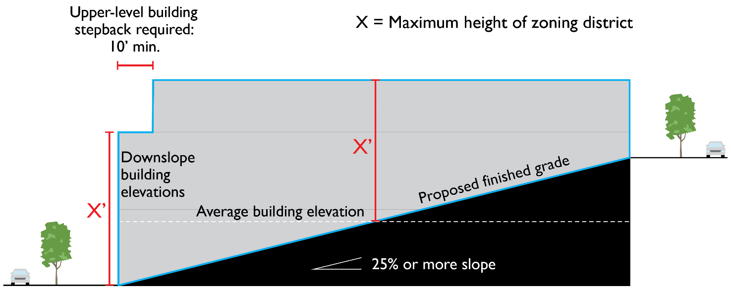
(2) Special Zone or Area-Specific Height Standards/Exceptions.
(a) For the RS, RL and RF zones, flat-roofed structures (featuring a roof slope of less than 10 degrees) are subject to the following maximum height/stepback plane: From a height of 22 feet at the minimum side setback, the maximum building height envelope shall step back at a 45-degree angle (one foot setback for every one foot of additional height) away from the side property line as shown in Figure 10.46.090(2)(a) below.
Figure 10.46.090(2)(a)
Height/stepback plane for flat-roofed buildings along the minimum side setback in the RS, RL, and RF zones.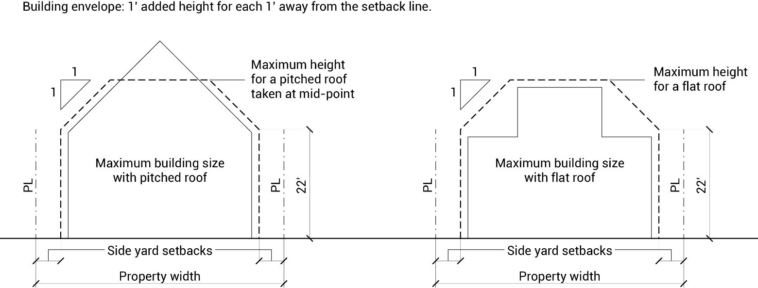
(b) For those portions of the RH zone north of the Wenatchee River, the maximum building height shall be 35 feet.
(c) Special Building Setback and Height Standards Where High Intensity Zones Abut Low to Medium Density Residential Zones. For RH, mixed use, or commercial zoned sites abutting RF, RS, RL, or RM zones, the side and rear setback shall be the same as the applicable residential zoning district, up to the maximum height limit of the applicable residential zoning district, above which the minimum side setback shall increase at a 45-degree angle inward up to the maximum height of the applicable zoning district. See Figure 10.46.090(2)(c) for an illustration.
Figure 10.46.090(2)(c)
Illustrating special building setback and height standards where high intensity zones abut low to medium density residential zones.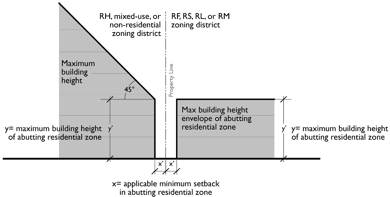
(d) Height Restrictions in the CD District. Portions of buildings in the CD district and within 60 feet of a public right-of-way shall be no higher than 35 feet.
(3) Exceptions – Exceeding Height Limits. The following structures may be erected above the height limits established in the dimensional standards in WCC 10.46.020 through 10.46.050:
(a) Except as may otherwise be prohibited by the FAA regulations, the height limitations do not apply to church spires, belfries, cupolas and domes not intended for residential purposes, or to monuments, water towers, observation towers, power transmission towers, silos, grain elevators, chimneys, smokestacks, derricks, conveyors, flag poles, radio masts, aerials and similar structures.
(b) Exceptions for Multifamily and Nonresidential Development.
(i) Roof structures housing or screening elevators, stairways, tanks, rooftop wind generators, ventilating fans or similar equipment required for building operation and maintenance may exceed the height limit by up to 10 feet, provided the area with the added height is limited to what is necessary to screen or enclose the use. Such structures constructed for nonresidential or multifamily uses are subject to screening standards in Chapter 10.62 WCC.
(ii) Fire or parapet walls may exceed the height limit by up to five feet. (Ord. 2020-35 § 3 (Exh. A); Ord. 2019-35 § 5)
10.46.100 Lot coverage calculations.
Lot coverage refers to the area of a lot which is covered/occupied by a roofed building or buildings, usually expressed in square feet (sf) or percentage (%) of land on the lot.
(1) Lot Coverage Calculation Details and Clarification.
(a) The area measured horizontally at the outside of external walls or supporting members of all primary and accessory structures.
(b) The roof overhang shall not be included in the lot coverage unless it exceeds two feet, in which case only the outer two feet is excluded from the calculation of lot coverage.
(c) Open beams and lattice work without a roof are not considered part of the lot coverage.
(d) Minor appurtenances such as bay windows, chimneys and trim not extending more than two feet from the primary wall, and not extending the enclosed floor area, do not count in lot coverage.
(e) Covered porches or decks that are not enclosed, are less than 120 square feet in footprint and are less than 42 inches above grade do not count as lot coverage.
(f) For lots which share an access easement (e.g., for a shared drive) the easement may be counted as lot area for the purpose of lot coverage calculation for the lot on which the easement is placed.
(2) Zone-Specific Exceptions.
(a) In the RH, OMU, RMU, and CN zones, the maximum lot coverage may be increased to 75 percent allowed for projects that employ structured parking for 80 percent of their required parking. Structured parking refers to parking facilities that are shared by multiple units or tenants and are enclosed within a structure. (Ord. 2019-35 § 5)
10.46.110 Density calculations and exceptions.
(1) Calculations for Determining Maximum Density, Where Expressed in Dwelling Units per Acre. The entire gross site area may be used in the calculation of the maximum allowed residential density including half of the adjacent city or county right-of-way (to the centerline).
(2) How to Calculate Density. Maximum density for an individual site shall be calculated by multiplying the site area (in acres) by the maximum dwelling units/acre in the applicable zone. When calculation results in a fraction, the fraction shall be rounded to the nearest whole number as follows:
(a) Fractions of 0.50 and above are rounded up.
(b) Fractions below 0.50 are rounded down.
(3) Exceptions to Density Standards. Exceptions to established density standards shall be granted in the following instances:
(a) When an exception is granted for a particular use described in Chapter 10.47 WCC.
(b) Additional density may be granted for affordable housing pursuant to RCW 35A.63.300 when local needs can be demonstrated compliant with the comprehensive plan. (Ord. 2020-35 § 3 (Exh. A); Ord. 2019-35 § 5)