


Chapter 19.20
MAPS
Sections:
19.20.010 Comprehensive Plan maps.
19.20.020 Comprehensive Plan map – Boundaries and designations.
19.20.030 Map and list of significant historic resources.
19.20.040 Map and list of planned development overlay zones.
19.20.050 Map and list of significant riparian corridors.
19.20.060 Map and list of significant wetlands.
19.20.070 Map and list of cultural sites (archeological).
19.20.080 Map and list of established and developing overlay zones (since 1999).
19.20.090 Map and study of special flood hazard areas.
19.20.010 Comprehensive Plan maps.
(1) Preface. It is the intent of this section to identify which maps are part of the St. Helens Comprehensive Plan.
(2) Goal. To make available maps to help understand this plan.
(3) Policy. Maps listed in this section shall be considered part of the St. Helens Comprehensive Plan and changes to the maps will be in accordance with any amendment to the plan.
(a) All lands within the urban growth boundary shall be identified on a map with designations in accordance with policies stated here in this Comprehensive Plan and changes made by amendment.
(b) Other maps that are required by policies herein shall be incorporated into this plan by amendment. (Ord. 2980 § 2, 2006)
19.20.020 Comprehensive Plan map – Boundaries and designations.*
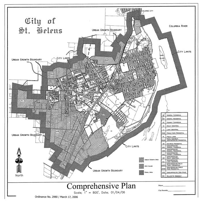
* Code reviser’s note: The Comprehensive Plan map is constantly changing, and this map may not be the most up to date. The current map is available at City Hall.
(Ord. 2980 § 2, 2006)
19.20.030 Map and list of significant historic resources.

|
# |
Name |
Legal |
Address |
Year Built |
Notes |
|---|---|---|---|---|---|
|
1 |
Courthouse |
|
240 The Strand |
1906 |
|
|
2 |
Courthouse Plaza |
Plaza, B. 11 |
Plaza Square |
1907 |
|
|
3 |
Columbia County Bank |
L. 18, B. 11 |
265 The Strand |
1908 |
City Hall |
|
4 |
Christ Episcopal Church |
L. 5, B. 11 |
260 S. 1st Street |
1897 |
Also 61 Plaza Square |
|
5 |
Richard Cox House |
L. 3, B.11 |
280 S. 1st Street |
1890 |
|
|
6 |
Morgus Building |
L. 13, B. 10 |
313, 315 & 317 The Strand |
1912 |
|
|
7 |
Muckle-George House |
L. 10-13, B. 19 |
105 Cowlitz Street |
1910 |
Formerly addressed as 305 S. 1st Street |
|
8 |
Italianate Cottage |
L. 5, B. 18 |
260 S. 2nd Street |
1885 |
|
|
9 |
Laud Rutherford House |
L. 21 & 22, B. 26 |
295 S. 2nd Street |
1911 |
|
|
10 |
John Gumm School |
L. 8-15, B. 26 |
251 St. Helens Street |
1919 |
|
|
11 |
Samuel Miles House |
L. 3, 4, 19 & 20, B. 17 |
175 S. 1st Street |
1886 |
|
|
12 |
Cliff-Ross House |
L.16, B. 17 |
145 S. 1st Street |
1905 |
|
|
13 |
Orin Shepard House |
L.13, B.17 |
115 S. 1st Street |
1926 |
|
|
14 |
Gray House |
L.12, B.17 |
105 S. 1st Street |
1905 |
|
|
15 |
Shinn House |
L. 9, B. 12 |
120 S. 1st Street |
1914 |
|
|
16 |
Henry Knighton House |
L. 17, B. 43 |
155 S. 4th Street |
1851 |
Moved to this location in 1938 |
|
17 |
Methodist Church |
L. 1 & 2, B. 47 |
560 Columbia Blvd. |
1924 |
|
|
18 |
Stone Wall |
Columbia Boulevard ROW |
Between N. 7th & N. 9th Streets |
1933 |
|
|
19 |
Basalt House |
L. 22, B. 112 |
1320 St. Helens Street |
1932 |
|
|
20 |
Basalt House |
L. 17, B. 123 |
255 North 14th Street |
1936 |
|
|
21 |
Basalt House |
Tualatin Street and DuBois Lane |
205 DuBois Lane |
1930 |
|
|
22 |
Railroad Station |
Railroad ROW |
2194 Columbia Blvd. |
1923 |
Burlington-Northern Railroad |
|
23 |
White Way House |
L. 4, B. 1, White Sub. |
116 White Way |
1859/1906 |
Formerly addressed as 2364 Columbia Boulevard; Remodeled in 1906 |

(Ord. 3250 §§ 2 (Att. A), 3 (Att. B), 4, 2020; Ord. 2980 § 2, 2006)
19.20.040 Map and list of planned development overlay zones.
(1) Columbia Heights Zoning Overlay.
(2) Shadow Canyon Planned Development.
(3) Gable Road North Planned Community Development.
(4) The Wetlands Planned Community Development.
(5) Ridgecrest Planned Community Development.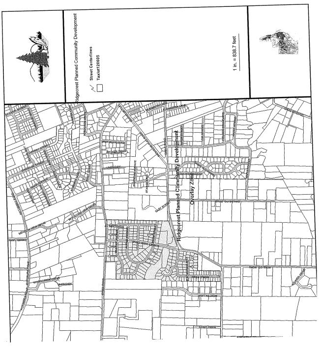
(6) Meadowbrook Planned Development.
(Ord. 2980 § 2, 2006)
19.20.050 Map and list of significant riparian corridors.

List of Significant Riparian Corridor Resources
As shown on the Pacific Habitat Services, Inc. maps identified as Attachment B*, and based upon the criteria chosen by the city council, the following riparian resources are considered as Significant Goal 5 Riparian Corridor Resources:
This list includes the riparian inventory that has two or more assessed functions rated as high and are considered fish-bearing waterways.
R-MC-5b
R-MC-7R
R-MC-7L
R-MC-8L
R-MC-10
R-MC-12
R-MC-13R
R-MC-13L
R-MC-15
R-MC-16a
R-MC-16b
R-MI-21
R-MI-22
R-MI-23R
R-MI-23L
R-MI-24
R-MI-26a
R-D-34
Note: The above-listed reaches are included in different form in the Pacific Habitat Services, Inc. report dated February 4, 2000, and amended March 24, 2000, to adjust for labeling errors on the maps and in the report.
(Ord. 2980 § 2, 2006)
* Code reviser’s note: The maps identified as Attachment B are available from the Planning Department at City Hall.
19.20.060 Map and list of significant wetlands.
(1) Map. See Wetland Riparian Protection Zones map in SHMC 19.20.050.
(2) List of Significant Wetlands.
|
Drainage Name and Unit |
|||
|---|---|---|---|
|
Dalton |
|
McNulty Creek |
|
|
|
D1 |
|
MC1 |
|
|
D2 |
|
MC2 |
|
|
D4 |
|
MC3 |
|
|
D6 |
|
MC5 |
|
|
D7 |
|
MC8 |
|
|
D8 |
|
MC9 |
|
|
D10 |
|
MC10 |
|
|
D11 |
|
MC16 |
|
|
D16 |
|
MC17 |
|
|
D17 |
|
MC20 |
|
|
D18 |
|
MC21 |
|
|
D19 |
|
MC22 |
|
|
D20 |
|
MC25 |
|
|
D21 |
|
MC26 |
|
|
D22 |
|
|
|
|
|
|
|
|
Frogmore Slough |
|
Unnamed Creek A |
|
|
|
F2 |
|
UA2 |
|
|
|
|
|
|
Jackass Canyon |
|
Unnamed Creek B |
|
|
|
J3 |
|
UB5A |
|
|
J6 |
|
UB5B |
|
|
|
|
UB6 |
|
|
|
|
|
|
Milton Creek |
|
|
|
|
|
M3 |
|
|
|
|
M5 |
|
|
|
|
M7 |
|
|
|
|
M8 |
|
|
|
|
M10 |
|
|
|
|
M11 |
|
|
|
|
M12 |
|
|
|
|
M15 |
|
|
(Ord. 3264 § 2 (Att. A), 2021; Ord. 2980 § 2, 2006)
19.20.070 Map and list of cultural sites (archeological).
(1) Archaeological Sites. A list of identified archaeological sites is located in the vault at City Hall. (Ord. 2980 § 2, 2006)
19.20.080 Map and list of established and developing overlay zones (since 1999).
See Comprehensive Plan map. The current map is available at City Hall. (Ord. 2980 § 2, 2006)
19.20.090 Map and study of special flood hazard areas.
The areas of special flood hazard identified by the Federal Insurance Administration in a scientific and engineering report entitled “The Flood Insurance Study for Columbia County, Oregon and Incorporated Areas,” dated November 26, 2010, with accompanying flood insurance rate map (FIRM) are on file at City Hall. (Ord. 3138 § 3 (Att. B), 2010)