


Chapter 16.40
STORM WATER RUNOFF AND SURFACE DRAINAGE
Sections:
16.40.010 What this chapter does.
16.40.030 Integrating development into the landscape.
16.40.040 Runoff and erosion control plan defined.
16.40.050 Maintaining natural drainage channels required.
16.40.060 Building on alluvial fans.
16.40.070 Building on slopes over 25 percent.
16.40.080 Grading away from structures.
16.40.090 Impervious cover on slopes – Diagram 16.40.090.
16.40.010 What this chapter does.
This chapter establishes development standards for all developments within Eagle Mountain City. When considering development applications, the planning director, planning commission and city council shall evaluate such applications using the provisions of this chapter. [Ord. O-23-2005 § 3 (Exh. 1(2) § 8.1)].
16.40.020 Purpose.
The purpose of this chapter is to set forth specific development standards that require all developments to provide for storm water runoff, identify steps to minimize flood hazards and establish standards to protect buildings and property from potential damage caused by surface waters. [Ord. O-23-2005 § 3 (Exh. 1(2) § 8.2)].
16.40.030 Integrating development into the landscape.
Clearing, excavation, and grading shall be in compliance with an approved plan, as required by the International Building Code or the International Residential Code. Excavation permits are required for this work unless it is part of a subdivision. Such plan shall be reviewed and approved by the city engineer prior to the commencement of clearing, excavating and grading activities. Clearing, excavation, and grading shall also be in compliance with the runoff and erosion management plan required by this chapter. [Ord. O-23-2005 § 3 (Exh. 1(2) § 8.3)].
16.40.040 Runoff and erosion control plan defined.
The principal strategy for managing runoff and erosion in the city is to allow natural channels to carry storm water and snowmelt runoff, within their historical capacity, to open spaces where it will infiltrate or evaporate. All developments shall submit a runoff and erosion plan with their application for a permit as required by this title. Each runoff and erosion management plan shall be consistent with the city’s overall runoff and erosion management plan and shall:
A. Minimized Disturbance of Landscape. Demonstrate how the area disturbed by construction at any one time will be minimized, and how disturbed areas will be stabilized during the construction period;
B. Disturbed Areas Stabilized. Demonstrate how disturbed areas will be promptly, permanently stabilized by revegetation and/or structural techniques to protect against erosion (revegetation with native plants is encouraged when feasible);
C. Channeled through Development. Demonstrate how storm water runoff, generated above the development, will be channeled through the development, including how the drainage ways used will be prepared to handle the anticipated flows without erosion or surface flooding;
D. Storm Water Retention and Detention. Demonstrate how the runoff generated by development will be retained on-site and infiltrated or evaporated, or how it will be released from the site to a natural channel at a rate that can be conveyed downstream without damaging that channel or downstream structures (culverts, bridges, detention basins, etc.), or creating flooding. Engineered storm drainage is required; and
E. Limiting Impervious Cover on Slopes. Demonstrate how the amount of impervious area complies with EMMC 16.40.090 and Diagram 16.40.090 when parcels have an average slope that ranges between eight and 25 percent. [Ord. O-23-2005 § 3 (Exh. 1(2) § 8.4)].
16.40.050 Maintaining natural drainage channels required.
Natural intermittent stream channels serve the critical function of conveying runoff through the city, and shall remain undeveloped except that such channels may require storm drainage structures or improvements to be installed as needed for the purpose of conveying or detaining runoff. Roads and utility lines shall be permitted to cross natural channels, but the number of such crossings shall be minimized. The design and construction of culverts and bridges shall be consistent with overall runoff and erosion management plan. Grading, planting, and the installation of structures needed to manage runoff and erosion or mitigate flood hazards shall also be permitted in natural channels, but only in compliance with an approved runoff and management plan, or the overall runoff and management plan. [Ord. O-23-2005 § 3 (Exh. 1(2) § 8.5)].
16.40.060 Building on alluvial fans.
Building on alluvial fans is not permitted. [Ord. O-23-2005 § 3 (Exh. 1(2) § 8.6)].
16.40.070 Building on slopes over 25 percent.
Building on slopes in excess of 25 percent is not permitted. A lot with slopes in excess of 25 percent may be eligible for a building permit if there is a building pad sufficient to construct the proposed structure without altering the grade of areas in excess of 25 percent so long as the grades of driveways and public streets accessing the property shall comply with the maximum grade allowances. [Ord. O-23-2005 § 3 (Exh. 1(2) § 8.7)].
16.40.080 Grading away from structures.
Positive drainage shall be required around buildings and structures by grading away from the exterior foundation wall at a minimum two percent slope, but in no case shall grading be less restrictive than the recommendations of the geotechnical report submitted for the subdivision. Grading away from the exterior foundation wall at a minimum two percent slope may be permitted on rapidly permeable soils. Sites shall also be graded so as to avoid surface ponding near buildings or structures, or in actively used outdoor spaces. Surface runoff must be channeled to detention or infiltration basins, as provided by a runoff and erosion management plan. Property owners shall be responsible to ensure that surface runoff does not enter adjacent properties nor cause damage to adjacent property owners. [Ord. O-23-2005 § 3 (Exh. 1(2) § 8.8)].
16.40.090 Impervious cover on slopes – Diagram 16.40.090.
Minimum guidelines shall be incorporated into the erosion and runoff control plans and will govern the amount of impervious area that can be placed on lots of various grades and soil conditions. The limitation of impervious areas shall be taken into account by the developer. Diagram 16.40.090, Impervious Area Limitations by Slope and Soil Characteristics, depicts the maximum area of a parcel that may be developed as impervious cover based upon the property’s average slope (predevelopment) and soil conditions. Property that has an average slope between eight and 25 percent shall comply with Diagram 16.40.090 and the following standards:
A. Thirty Percent Impervious Lot Cover. A lot may be developed with 30 percent of the total lot area covered with impervious area if the average slope of the ground is 25 percent or less and the soils are only slightly erodible. For example, to maintain a building footprint of 1,500 square feet and having an additional 1,500 square feet of impervious covering consisting of a driveway, sidewalks, and patios, the lot shall be a minimum of 10,000 square feet.
B. Twenty-Five Percent Impervious Lot Cover. A lot may be developed with 25 percent of the total lot area covered with impervious area if the average slope of the ground is 25 percent or less and the soils are slightly to slightly moderately erodible. For example, to maintain a building footprint of 1,500 square feet and having an additional 1,500 square feet of impervious covering consisting of a driveway, sidewalks, and patios, the lot would have to be 12,000 square feet.
C. Twenty Percent Impervious Lot Cover. A lot may be developed with 20 percent of the total lot area covered with impervious area under the following conditions: (1) if the average slope of the ground is 25 percent or less and the soils are moderately erodible; (2) if the average slope of the ground is 15 percent or less and the soils are erodible. For example, to maintain a building footprint of 1,500 square feet and having an additional 1,500 square feet of impervious covering consisting of a driveway, sidewalks, and patios, the lot would have to be 15,000 square feet.
D. Five Percent Impervious Lot Cover. A lot may be developed with five percent of the total lot area covered with impervious area if the average slope of the ground is 15 percent or less and the soils are moderately erodible. For example, to maintain a building footprint of 1,500 square feet and having an additional 1,500 square feet of impervious covering consisting of a driveway, sidewalks, and patios, the lot would have to be 60,000 square feet.
E. One Percent Impervious Lot Cover. Development is prohibited on slopes greater than 25 percent.
F. Diagram 16.40.090, Impervious Area Limitations by Slope and Soil Characteristics, depicts the maximum area of a parcel that may be developed as impervious cover based upon the property’s average slope (predevelopment) and soil conditions. The following text explains how impervious cover, slope, and soil conditions contribute to erosion and runoff.
The impervious areas that are built on a lot increase the amount of water that is concentrated in the pervious portions of the lot. Impervious areas are comprised of the building footprints, sidewalks, driveways, patios, or other highly compacted areas. In essence, impervious area is any material that sheds water rather than allowing the water to soak into the soil structure. The increased concentration of water is exacerbated by the lot’s slope and soil conditions in the following ways.
Increased slope intensifies water’s velocity and reduces the amount of water that actually infiltrates into the ground. Because the water is moving faster, there is less likelihood that the water will infiltrate into the ground. Therefore, with this increased amount of water traveling at high velocities, the type of soils becomes critical. Slope is most readily determined by the predevelopment conditions. However, the postdevelopment slope has the final and lasting effect upon the velocity of the storm water runoff.
Each type of soil exhibits different responses to water flowing over it. Sandy and silty soils tend to erode easily because there are no clay components to bind different particles together. Clayey soils are soils that are well graded with clay components and tend to bind tightly and will not be washed away by water easily.
Diagram 16.40.090 – Impervious Area Limitations by Slope and Soil Characteristics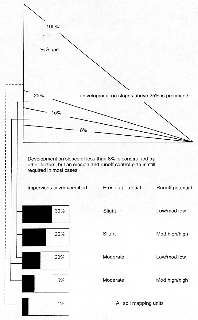
[Ord. O-36-2020 § 2 (Exh. A); Ord. O-23-2005 § 3 (Exh. 1(2) § 8.9)].