


Chapter 21.73
SITE PLANS AND RIGHT-OF-WAY ACCESS
Sections:
21.73.010 Site plan – General.
21.73.020 Site plan – Level one.
21.73.030 Site plan – Level two.
21.73.100 Right-of-way access plan – General.
21.73.110 Right-of-way access plan – Level one.
21.73.120 Right-of-way access plan – Level two.
21.73.130 Right-of-way access plan – Level three.
21.73.200 Visibility at intersections.
21.73.010 Site plan – General.
a. When a site plan is required by other provisions of the zoning code, the applicant shall submit to the City Planner for approval a site plan prepared in conformance with this chapter.
b. The level of site plan required is specified in the applicable zoning district regulations. If the level is not specified, a level one plan is required. [Ord. 08-29, 2008].
21.73.020 Site plan – Level one.
A level one site plan shall show on a survey, map or plan of the subject property, drawn to a scale of not less than one inch equals 20 feet, all of the following:
a. The precise location of the lot boundaries and all setbacks and easements.
b. The precise location and dimensions of all existing and proposed structures, including any proposed changes to the exterior dimensions of existing structures.
c. Elevation drawings and dimensions of all existing and proposed structures, including any proposed changes to exterior dimensions of existing structures.
d. Existing site features and conditions, including topography, drainage, streams, water bodies, wetlands, lines of mean high tide, storm berms, areas prone to erosion, and the general location of vegetation.
e. The precise location of all existing and proposed structures in relation to existing and proposed streets and other rights-of-way.
f. Access, including proposed driveway and curb cuts, with arrows indicating vehicular traffic patterns into and out of the site and to and from all parking areas.
g. On-site traffic and pedestrian circulation systems, and a detailed parking plan.
h. Pedestrian access to adjacent public lands, waters, walkways and trails. Where practical, safe, and where other means of access have not been provided, access easements may be required.
i. A grading and drainage plan indicating all cuts, fills and areas of disturbance. The plan shall display elevation changes and cut and fill quantities.
j. The location of the site in relation to other existing uses on neighboring properties. [Ord. 08-29, 2008].
21.73.030 Site plan – Level two.
A level two site plan shall show on a survey, map or plan of the subject property, drawn to a scale of not less than one inch equals 20 feet, all of the following:
a. All information required by HCC 21.73.020(a) through (e);
b. Access, including proposed driveway and curb cuts, with arrows indicating vehicular traffic patterns into and out of all loading berths or areas;
c. Turning radius for vehicles;
d. The location and proposed screening of open storage areas;
e. Basic floor plans and location of all existing and proposed structures;
f. Location of utilities;
g. Proposed signs and lighting;
h. The location of the site in relation to residential uses and other existing industrial uses on adjacent properties;
i. Location of snow storage. [Ord. 08-29, 2008].
21.73.100 Right-of-way access plan – General.
a. When a right-of-way access plan is required by other provisions of the zoning code, the applicant shall submit to the City Planner for approval a right-of-way access plan prepared in conformance with this chapter.
b. The level of right-of-way access plan required is specified in the applicable zoning district regulations. If the level is not specified, a level one plan is required. [Ord. 08-29, 2008].
21.73.110 Right-of-way access plan – Level one.
A level one right-of-way access plan shall conform to all of the following:
a. Show all points of access to rights-of-way.
b. Any access roads and frontage roads shall conform to the policies of the Master Roads and Streets Plan and the ordinances of the City. [Ord. 08-29, 2008].
21.73.120 Right-of-way access plan – Level two.
A level two right-of-way access plan shall conform to all of the following:
a. Show all points of access to rights-of-way.
b. Entrances onto arterials and collectors shall be minimized, and individual businesses shall share access to rights-of-way whenever reasonable.
c. Any access roads and frontage roads shall conform to the controlling street plan elements of the Homer Comprehensive Plan.
d. The plan shall require visibility clearance according to HCC 21.73.200. [Ord. 08-29, 2008].
21.73.130 Right-of-way access plan – Level three.
A level three right-of-way access plan shall conform to all of the following:
a. Show all points of access to rights-of-way.
b. Vehicular Circulation and Access.
1. Street access shall be limited to one entrance and one exit per street. One combined entrance/exit is encouraged to facilitate traffic movement on adjacent streets.
2. To minimize turning movements onto adjacent public roads, developers are encouraged to provide internal circulation systems that connect to adjacent developments. When several adjacent lots front one street it is preferred that they share one driveway or street access. Site design shall continue internal vehicular ways in order to reduce the number of driveway and curb cuts onto the Sterling Highway. Curb cuts onto the Sterling Highway shall be kept to an absolute minimum.
3. Facilities and access routes for deliveries, service and maintenance shall be separated when practical from public access routes and parking areas.
c. Where applicable, frontage roads shall conform to the Master Roads and Streets Plan, the Transportation Plan, and the ordinances of the City.
d. The plan shall require visibility clearance according to HCC 21.73.200. [Ord. 08-29, 2008].
21.73.200 Visibility at intersections.
a. When a visibility clearance is required by other provisions of the zoning code, visibility clearance for vehicles shall be protected as specified in this section.
b. At the intersection of any private drive or entrance or exit for a parking area with a public street, no fence, wall, hedge or other planting or structure forming a material impediment of visibility between a height of two and one-half feet and eight feet shall be erected, planted, placed or maintained and no vehicle so impeding visibility shall be parked within triangular areas defined by lines connecting points as follows:
Beginning at the point where the midline of the private drive or entrance or exit for a common parking area intersects the public right-of-way, thence to a point 35 feet along the right-of-way line in the direction of approaching traffic, thence to a point 25 feet toward the interior of the property at the previously described midline, and thence to point of beginning.
This protected area may sometimes be referred to as a “sight triangle” or “visibility triangle.” See Figure 1.
c. Unless otherwise required by law, no visibility clearance area is required on the side of the drive, entrance or exit away from approaching traffic on the same side of the street.
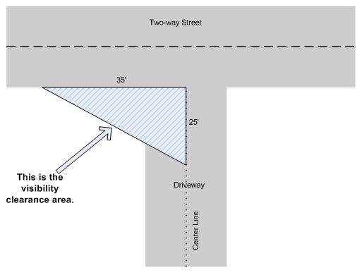
Figure 1
Visibility Clearance Area
[Ord. 08-29, 2008].