


Chapter 15.20
FLOODPLAIN MANAGEMENT AND FLOOD DAMAGE PREVENTION1
Sections:
ARTICLE I. DEFINITIONS
15.20.020 Definitions related to flood and stormwater control measures.
ARTICLE II. SCOPE AND ADMINISTRATION, GENERAL PROVISIONS
15.20.040 Statutory authority.
15.20.060 Purposes and objectives.
15.20.070 Coordination with California Building Standards Code.
15.20.090 Disclaimer of liability.
15.20.110 Abrogation and greater restrictions.
ARTICLE III. APPLICABILITY
15.20.120 General applicability.
15.20.130 Establishment of flood hazard areas.
ARTICLE IV. DUTIES AND POWERS OF THE FLOODPLAIN ADMINISTRATOR
15.20.190 Substantial improvement and substantial damage determinations.
ARTICLE V. PERMITS FOR FLOODPLAIN DEVELOPMENT
15.20.220 Application for permit.
15.20.240 Other permits required.
15.20.260 Suspension or revocation.
15.20.270 Appeals of decisions.
ARTICLE VI. SITE PLANS AND CONSTRUCTION DOCUMENTS
15.20.280 Information for development in flood hazard areas.
15.20.290 Information in flood hazard areas without base flood elevations (approximate Zone A).
15.20.300 Additional analyses and certifications.
15.20.310 Submission of additional data.
ARTICLE VII. INSPECTIONS
15.20.320 Inspections, in general.
15.20.330 Inspections of development other than buildings and structures.
15.20.340 Inspections of manufactured home installations.
15.20.350 Buildings and structures.
ARTICLE VIII. VARIANCES
15.20.360 Variance procedures.
ARTICLE IX. VIOLATIONS
15.20.390 Unlawful continuance.
ARTICLE X. FLOOD-RESISTANT DEVELOPMENT--BUILDINGS AND STRUCTURES
15.20.400 Requirements for buildings and structures in flood hazard areas.
15.20.410 Detached garages and accessory storage structures.
15.20.420 Utility and miscellaneous Group U.
15.20.430 Agricultural structures.
ARTICLE XI. FLOOD-RESISTANT DEVELOPMENT--SUBDIVISIONS
15.20.440 Minimum requirements.
15.20.450 Subdivision requirements.
ARTICLE XII. FLOOD-RESISTANT DEVELOPMENT--SITE IMPROVEMENTS, UTILITIES, AND LIMITATIONS
15.20.460 Minimum requirements.
15.20.470 Sanitary sewer facilities.
15.20.480 Water supply facilities.
15.20.490 Development in floodways.
15.20.500 Limitations on placement of fill.
ARTICLE XIII. FLOOD-RESISTANT DEVELOPMENT--INSTALLATION OF MANUFACTURED HOMES
15.20.540 General elevation requirement.
15.20.550 Elevation requirement for certain existing manufactured home parks and subdivisions.
15.20.560 Flood-damage-resistant materials.
15.20.580 Protection of mechanical equipment and outside appliances.
ARTICLE XIV. FLOOD-RESISTANT DEVELOPMENT--RECREATIONAL VEHICLES
15.20.590 Temporary placement.
15.20.600 Permanent placement.
ARTICLE XV. FLOOD-RESISTANT DEVELOPMENT--OTHER DEVELOPMENT
15.20.610 General requirements for other development.
15.20.630 Requirements for temporary structures and temporary storage in flood hazard areas.
15.20.640 Fences in floodways.
15.20.650 Retaining walls, sidewalks and driveways in floodways.
15.20.660 Roads and watercourse crossings in floodways.
ARTICLE XVI. FLOOD CONTROL PROJECTS
15.20.680 Flood control projects--General.
15.20.690 Flood control projects--Applications.
ARTICLE XVII. STREAM OR CREEK SETBACKS
15.20.710 Reduction of setbacks.
15.20.720 Construction of roadways and infrastructure construction.
ARTICLE I. DEFINITIONS
15.20.010 General.
The following words and terms shall, for the purposes of these regulations, have the meanings shown herein. Where terms are not defined in these regulations and are defined in the building code (CCR Title 24 Part 2) and used in the residential code (CCR Title 24 Part 2.5), such terms shall have the meanings ascribed to them in those codes. Where terms are not defined in these regulations or the building code, such terms shall have ordinarily accepted meanings such as the context implies. (Ord. 544 (Att. A), 2025)
15.20.020 Definitions related to flood and stormwater control measures.
A. "Accessory structure" means a structure on the same parcel of property as a principal structure and the use of which is incidental to the use of the principal structure. For floodplain management purposes, the term includes only accessory structures used for parking and storage.
B. "Agricultural structure" means a walled and roofed structure used exclusively for agricultural purposes or uses in connection with the production, harvesting, storage, raising, or drying of agricultural commodities and livestock, including aquatic organisms. Structures that house tools or equipment used in connection with these purposes or uses are also considered to have agricultural purposes or uses.
C. "Alteration of a watercourse" means a dam, impoundment, channel relocation, change in channel alignment, channelization, or change in cross-sectional area of the channel or the channel capacity, or any other form of modification which may alter, impede, retard or change the direction and/or velocity of the riverine flow of water during conditions of the base flood.
D. "ASCE 24" means the standard Flood-resistant Design and Construction, referenced by the building code, developed and published by the American Society of Civil Engineers. Where cited, ASCE 24 refers to the edition of the standard that is referenced by the building code.
E. "Base flood" means the flood having a one percent chance of being equaled or exceeded in any given year.
F. "Base flood elevation" means the elevation of the base flood, including wave height, relative to the National Geodetic Vertical Datum (NGVD), North American Vertical Datum (NAVD) or other datum specified on the flood insurance rate map (FIRM).
G. "Basement" means, for the purpose of floodplain management, the portion of a building having its floor subgrade (below ground level) on all sides.
H. "Building code" means California Code of Regulations Title 24, the California Building Standards Code, the family of building codes specifically adopted by the state of California including, but not limited to:
1. Part 2, applicable to buildings and structures other than dwellings within the scope of this part.
2. Part 2.5, applicable to one- and two-family dwellings and townhouses not more than three stories, and accessory structures.
3. Part 10, applicable to existing buildings (as defined in that code).
4. Other specified codes.
I. "Creek/stream setback" refers to the area encompassing the streambed channel, bed, and top of bank or the landward edge (dripline) of riparian vegetation; whichever is greater.
J. "Design flood" means the flood associated with the greater of the following two areas:
1. Area with a floodplain subject to a one percent or greater chance of flooding in any year.
2. Area designated as a flood hazard area on a community’s flood hazard map, or otherwise legally designated.
K. "Design flood elevation" means the elevation of the "design flood," including wave height, relative to the datum specified on the community’s legally designated flood hazard map. In areas designated as Zone AO, the design flood elevation shall be the elevation of the highest existing grade of the building’s perimeter plus the depth number (in feet) specified on the flood hazard map. In areas designated as Zone AO where a depth number is not specified on the map, the depth number shall be taken as being equal to two feet (six hundred ten mm).
L. "Development" means any manmade change to improved or unimproved real estate, including, but not limited to, buildings or other structures, temporary structures, temporary or permanent storage of materials, mining, dredging, filling, grading, paving, excavations, drilling operations, flood control projects, and other land-disturbing activities.
M. "Earthmoving or earth-disturbing activity" means any activity that involves vegetation clearing, grading, excavation, compaction of the soil, or the creation of fills and embankments to prepare a site for construction of roads, structures, landscaping, new planting, and other improvements (including agricultural roads, and vineyard avenues or tractor turnaround areas necessary for ongoing agricultural operations). It also means excavations, fills, or grading which constitute engineered works or improvements.
N. "Encroachment" means the placement of fill, excavation, buildings, permanent structures or other development into a flood hazard area which may impede or alter the flow capacity of riverine flood hazard areas.
O. "Ephemeral, perennial or intermittent stream" means any natural channel with defined bed and banks containing flowing water or showing evidence of having contained flowing water, such as deposit of rock, sand, gravel, or soil, that does not meet the definition of a stream (see subsection QQ of this section).
1. Ephemeral streams have less flow than intermittent streams and typically contain stormwater runoff during and after relatively large rainfall events but are normally dry for most of the year.
2. Perennial streams normally flow almost year-round, usually at least into early summer.
3. Intermittent streams typically contain stormwater runoff during winter months but are normally dry during the summer months.
4. Ephemeral, perennial, and intermittent streams do not include features such as manmade drainage ditches, stormwater systems, or concrete channels.
P. "Exceptional hardship" means, for the purpose of variances from these regulations or the building code, the exceptional difficulty that would result from a failure to grant a requested variance. Mere economic or financial hardship is not exceptional. Inconvenience, aesthetic considerations, physical handicaps, personal preferences, or the disapproval of one’s neighbors do not, as a rule, qualify as exceptional hardships. All of these circumstances can be resolved through other means without granting variances, even when the alternatives are more expensive or require the property owner to build elsewhere or put the parcel to a different use than originally intended.
Q. "Existing manufactured home park or subdivision" means a manufactured home park or subdivision for which the construction of facilities for servicing the lots on which the manufactured homes are to be affixed (including, at a minimum, the installation of utilities, the construction of streets, and either final site grading or the pouring of concrete pads) was completed prior to the adoption of the ordinance codified in this chapter.
R. "Expansion to an existing manufactured home park or subdivision" means the preparation of additional sites by the construction of facilities for servicing the lots on which the manufactured homes are to be affixed (including the installation of utilities, the construction of streets, and either final site grading or the pouring of concrete pads).
S. "Flood or flooding" means a general and temporary condition of partial or complete inundation of normally dry land from:
1. The overflow of inland or tidal waters.
2. The unusual and rapid accumulation or runoff of surface waters from any source.
3. Mudslides (i.e., mudflows) which are proximately caused by flooding.
T. "Flood control project" means a dam or barrier designed and constructed to keep water away from or out of a specified area, including, but not limited to, levees, floodwalls, and channelization.
U. "Flood-damage-resistant materials" means any construction material capable of withstanding direct and prolonged contact with floodwaters without sustaining any damage that requires more than cosmetic repair.
V. "Flood hazard area" means the greater of the following two areas:
1. The area within a floodplain subject to a one percent or greater chance of flooding in any year.
2. The area designated as a flood hazard area on the community’s flood hazard map, or otherwise legally designated.
W. "Flood insurance rate map (FIRM)" means an official map of a community on which the Federal Emergency Management Agency (FEMA) has delineated both the special flood hazard areas and the risk premium zones applicable to the community.
X. "Flood insurance study" means the official report provided by the Federal Emergency Management Agency containing the flood insurance rate map (FIRM), the flood boundary and floodway map (FBFM), the water surface elevation of the base flood and supporting technical data.
Y. "Floodplain administrator" means the community official designated by title to administer and enforce the floodplain management regulations.
Z. "Floodway" means the channel of the river, creek or other watercourse and the adjacent land areas that must be reserved in order to discharge the base flood without cumulatively increasing the water surface elevation more than a designated height.
AA. "Fraud or victimization" means, for the purpose of variances from these regulations or the building code, the intentional use of deceit to deprive another of rights or property, making a victim of the deprived person or the public. As it pertains to buildings granted variances to be constructed below the elevation required by the building code, future owners or tenants of such buildings and the community as a whole may bear the burden of increased risk of damage from floods, increased cost of flood insurance, and increased recovery costs, inconvenience, danger, and suffering.
BB. "Functionally dependent use" means a use that cannot perform its intended purpose unless it is located or carried out in close proximity to water, including only docking facilities, port facilities necessary for the loading or unloading of cargo or passengers, and shipbuilding or ship repair facilities. The term does not include long-term storage, manufacture, sales or service facilities.
CC. "Highest adjacent grade" means the highest natural elevation of the ground surface prior to construction next to the proposed walls or foundation of a structure.
DD. "Historic structure" means any structure that is:
1. Listed individually in the National Register of Historic Places (a listing maintained by the Department of the Interior) or preliminarily determined by the Secretary of the Interior as meeting the requirements for individual listing on the National Register;
2. Certified or preliminarily determined by the Secretary of the Interior as contributing to the historical significance of a registered historic district or a district preliminarily determined by the Secretary to qualify as a registered historic district;
3. Individually listed on the inventory of historic places maintained by the California Office of Historic Preservation; or
4. Individually listed on the Angels Camp Register of Cultural Resources.
EE. "Letter of map change (LOMC)" means an official determination issued by FEMA that amends or revises an effective flood insurance rate map or flood insurance study. Letters of map change include:
1. Letter of Map Amendment (LOMA). An amendment based on technical data showing that a property was incorrectly included in a designated special flood hazard area. A LOMA amends the current effective flood insurance rate map and establishes that a specific property, portion of a property, or structure is not located in a special flood hazard area.
2. Letter of Map Revision (LOMR). A revision based on technical data that may show changes to flood zones, flood elevations, special flood hazard area boundaries and floodway delineations, and other planimetric features.
3. Letter of Map Revision Based on Fill (LOMR-F). A determination that a structure or parcel of land has been elevated by fill above the base flood elevation and is, therefore, no longer located within the special flood hazard area. In order to qualify for this determination, the fill must have been permitted and placed in accordance with the community’s floodplain management regulations.
4. Conditional Letter of Map Revision (CLOMR). A formal review and comment as to whether a proposed flood protection project or other project complies with the minimum NFIP requirements for such projects with respect to delineation of special flood hazard areas. A CLOMR does not revise the effective flood insurance rate map or flood insurance study; upon submission and approval of certified as-built documentation, a letter of map revision may be issued by FEMA to revise the effective FIRM.
FF. "Light-duty truck" means, as defined in 40 C.F.R. 86.082-2, any motor vehicle rated at eight thousand five hundred pounds gross vehicular weight rating or less which has a vehicular curb weight of six thousand pounds or less and which has a basic vehicle frontal area of forty-five square feet or less, which is:
1. Designed primarily for purposes of transportation of property or is a derivation of such a vehicle; or
2. Designed primarily for transportation of persons and has a capacity of more than twelve persons; or
3. Available with special features enabling off-street or off-highway operation and use.
GG. "Lowest floor" means the lowest floor of the lowest enclosed area, including basement, but excluding any unfinished or flood-resistant enclosure, usable solely for vehicle parking, building access or limited storage; provided, that such enclosure is not built so as to render the structure in violation of the nonelevation requirements of the building codes.
HH. "Manufactured home" means a structure that is transportable in one or more sections, built on a permanent chassis, designed for use as a single-family dwelling with or without a permanent foundation when connected to the required utilities, and constructed to the Manufactured Home Construction and Safety Standards promulgated by the U.S. Department of Housing and Urban Development. Also see definitions in Health and Safety Code Sections 18000(a)(2) and 18001(a). For the purposes of floodplain management, the term also includes mobile homes and recreational vehicles, park trailers, travel trailers and similar transportable structures that are placed on a site for one hundred eighty consecutive days or longer.
II. "Manufactured home park or subdivision" means a parcel (or contiguous parcels) of land divided into two or more manufactured home lots for rent or sale.
JJ. "Market value" means the price at which a property will change hands between a willing buyer and a willing seller, neither party being under compulsion to buy or sell and both having reasonable knowledge of relevant facts. As used in these regulations, the term refers to the market value of buildings and structures, excluding the land and other improvements on the parcel. Market value may be established by one of the following methods: (1) actual cash value (replacement cost depreciated for age and quality of construction); (2) tax assessment value adjusted to approximate market value by a factor provided by the property appraiser; or (3) a qualified independent appraiser.
KK. "New manufactured home park or subdivision" means a manufactured home park or subdivision for which the construction of facilities for servicing the lots on which the manufactured homes are to be affixed (including, at a minimum, the installation of utilities, the construction of streets, and either final site grading or the pouring of concrete pads) was completed on or after December 3, 1996.
LL. "Nuisance" means that which is injurious to safety or health of an entire community or neighborhood, or any considerable number of persons, or unlawfully obstructs the free passage or use, in the customary manner, of any navigable lake, or river, bay, stream, canal, or basin.
MM. "Permit for floodplain development" means an official document or certificate issued by the community, or other evidence of approval or concurrence, which authorizes performance of specified development activities that are located in flood hazard areas and that are determined to be compliant with these regulations.
NN. "Recreational vehicle" means a vehicle that is built on a single chassis, four hundred square feet (37.16 m2) or less when measured at the largest horizontal projection, designed to be self-propelled or permanently towable by a light-duty truck, and designed primarily not for use as a permanent dwelling but as temporary living quarters for recreational, camping, travel or seasonal use. A recreational vehicle is ready for highway use when it is on its wheels or jacking system, is attached to the site only by quick disconnect type utilities and security devices and has no permanently attached additions. Also see definitions in Health and Safety Code Section 18010.
OO. "Riverine" means relating to, formed by, or resembling a river (including tributaries), stream, brook, etc.
PP. "Special flood hazard area (SFHA)" means the land area subject to flood hazards and shown on a flood insurance rate map or other flood hazard map as Zone A, AE, A1-30, A99, AR, AO, AH, V, VO, VE, or V1-30.
QQ. "Streams" are defined as any of the following:
1. A watercourse designated by a solid line or dash and three dots symbol on the largest scale of the United State Geological Survey maps most recently published, or any replacement to that symbol. These are often referred to as "blue-line streams."
2. Any watercourse which has a well-defined channel with a depth greater than four feet and banks steeper than 3:1 and that contains hydrophilic vegetation, riparian vegetation or woody vegetation including tree species greater than ten feet in height.
3. Any watercourse designated as a stream, or tributary within the Angels Camp sphere of influence and area of interest in Table 4-4 of the Angels Camp 2020 General Plan Conservation and Open Space Element.
RR. "Substantial damage" means damage of any origin sustained by a structure whereby the cost of restoring the structure to its before-damaged condition would equal or exceed fifty percent of the market value of the structure before the damage occurred.
SS. "Substantial improvement" means any repair, reconstruction, rehabilitation, alteration, addition or other improvement of a building or structure, the cost of which equals or exceeds fifty percent of the market value of the structure before the improvement or repair is started. When the structure has sustained substantial damage, any repairs are considered substantial improvement regardless of the actual repair work performed. The term does not, however, include either:
1. Any project for improvement of a building required to correct existing health, sanitary or safety code violations identified by the building official and that are the minimum necessary to assure safe living conditions.
2. Any alteration of a historic structure; provided, that the alteration will not preclude the structure’s continued designation as a historic structure.
TT. "Utility and miscellaneous Group U" means buildings and structures of an accessory character and miscellaneous structure not classified in any special occupancy, as described in the building code.
UU. "Variance" means a grant of relief from the requirements of these regulations which permits construction in a manner otherwise prohibited and where specific enforcement would result in exceptional hardship.
VV. "Violation" means a development that is not fully compliant with these regulations or the flood provisions of the building code, as applicable.
WW. "Watercourse" means a river, creek, stream, channel or other topographic feature in, on, through, or over which water flows at least periodically.
XX. "Wetland" means those areas that meet either the federal definition of wetlands, as set forth in 33 CFR Section 328.3, or the state of California definition of wetland as adopted by the State Water Resources Control Board (SWRCB). In the event of a conflict between the state and federal definition, whichever definition is more protective shall control.
1. The federal definition of "wetland" is described as those areas that are inundated or saturated by surface water or groundwater at a frequency and duration sufficient to support, and that under normal circumstances do support, a prevalence of vegetation typically adapted for life in saturated soil conditions. Constructed conveyances of stormwater or wastewater (e.g., leachfields) are not considered to meet the definition of wetlands.
2. The SWRCB definition of "wetland" is described using three criteria: wetland hydrology, wetland soils, and (if vegetated) wetland plants. An area is "wetland" if, under normal circumstances, (a) the area has continuous or recurrent saturation of the upper substrate caused by groundwater, or shallow surface water, or both; (b) the duration of such saturation is sufficient to cause anaerobic conditions in the upper substrate; and (c) the area’s vegetation is dominated by hydrophytes or the area lacks vegetation, defined as less than five percent areal coverage of plants at the peak of the growing season. (Ord. 544 (Att. A), 2025)
ARTICLE II. SCOPE AND ADMINISTRATION, GENERAL PROVISIONS
15.20.030 Title.
These regulations, in combination with the flood provisions of California Code of Regulations Title 24, the California Building Standards Code (hereinafter "building codes," consisting of Part 2 (building), Part 2.5 (residential), Part 10 (existing building), and related codes), shall be known as the floodplain management regulations of the city of Angels Camp (hereinafter "these regulations"). (Ord. 544 (Att. A), 2025)
15.20.040 Statutory authority.
The Legislature of the State of California has, in Government Code Sections 65302, 65560, and 65800, conferred upon local governments the authority to adopt regulations designed to promote the public health, safety, and general welfare of its citizenry. Therefore, the city council of the city of Angels Camp does hereby adopt the following floodplain management regulations. (Ord. 544 (Att. A), 2025)
15.20.050 Scope.
The provisions of these regulations, in combination with the flood provisions of the building codes, shall apply to all proposed development entirely or partially in flood hazard areas established in Section 15.20.130. (Ord. 544 (Att. A), 2025)
15.20.060 Purposes and objectives.
The purposes and objectives of these regulations and the flood load and flood-resistant construction requirements of the building codes are to promote the public health, safety and general welfare and to minimize public and private losses due to flood conditions in specific flood hazard areas through the establishment of comprehensive regulations for management of flood hazard areas, designed to:
A. Minimize unnecessary disruption of commerce, access and public service during times of flooding.
B. Require the use of appropriate construction practices in order to prevent or minimize future flood damage.
C. Manage the alteration of natural floodplains, stream channels and shorelines to minimize the impact of development on the natural and beneficial functions of the floodplain.
D. Manage filling, grading, dredging, mining, paving, excavation, drilling operations, storage of equipment or materials, and other development which may increase flood damage or erosion potential.
E. Prevent or regulate the construction of flood barriers which will divert floodwater or increase flood hazards.
F. Contribute to improved construction techniques in the floodplain.
G. Minimize damage to public and private facilities and utilities.
H. Help maintain a stable tax base by providing for the sound use and development of flood hazard areas.
I. Minimize the need for rescue and relief efforts associated with flooding.
J. Ensure that property owners, occupants, and potential owners are aware of property located in flood hazard areas.
K. Minimize the need for future expenditure of public funds for flood control projects and response to and recovery from flood events.
L. Meet the requirements of the National Flood Insurance Program for community participation as set forth in 44 CFR Section 59.22. (Ord. 544 (Att. A), 2025)
15.20.070 Coordination with California Building Standards Code.
Pursuant to the requirement established in state statute that the city of Angels Camp administer and enforce the California Building Standards Code, the city council of the city of Angels Camp hereby acknowledges that the building codes contain certain provisions that apply to the design and construction of buildings and structures in flood hazard areas. Therefore, these regulations are intended to be administered and enforced in conjunction with the building codes. (Ord. 544 (Att. A), 2025)
15.20.080 Warning.
The degree of flood protection required by these regulations and the building codes is considered reasonable for regulatory purposes and is based on scientific and engineering considerations. Larger floods can and will occur. Flood heights may be increased by manmade or natural causes. Enforcement of these regulations and the building codes does not imply that land outside the special flood hazard areas, or that uses permitted within such flood hazard areas, will be free from flooding or flood damage. The flood hazard areas and base flood elevations contained in the flood insurance study and shown on flood insurance rate maps and the requirements of 44 CFR Sections 59 and 60 may be revised by the Federal Emergency Management Agency, requiring this community to revise these regulations to remain eligible for participation in the National Flood Insurance Program. No guarantee of vested use, existing use, or future use is implied or expressed by compliance with these regulations. (Ord. 544 (Att. A), 2025)
15.20.090 Disclaimer of liability.
These regulations shall not create liability on the part of the city council, any officer or employee thereof, the state of California, or the Federal Emergency Management Agency, for any flood damage that results from reliance on these regulations or any administrative decision lawfully made hereunder. The floodplain administrator and any employee charged with the enforcement of these regulations, while acting for the community in good faith and without malice in the discharge of the duties required by these regulations or other pertinent law or ordinance, shall not thereby be rendered liable personally and is hereby relieved from personal liability for any damage accruing to persons or property as a result of any act or by reason of an act or omission in the discharge of official duties. Any suit instituted against an officer or employee because of an act performed by that officer or employee in the lawful discharge of duties and under the provisions of these regulations shall be defended by a legal representative of the community until the final termination of the proceedings. The floodplain administrator and any subordinate shall not be liable for cost in any action, suit or proceeding that is instituted in pursuance of the provisions of these regulations. (Ord. 544 (Att. A), 2025)
15.20.100 Other laws.
The provisions of these regulations shall not be deemed to nullify any provisions of local, state or federal law. (Ord. 544 (Att. A), 2025)
15.20.110 Abrogation and greater restrictions.
These regulations supersede any ordinance in effect in flood hazard areas. However, these regulations are not intended to repeal, abrogate or impair any existing ordinances including land development regulations, subdivision regulations, zoning ordinances, stormwater management regulations, or building codes, nor any existing easements, covenants, or deed restrictions. In the event of an overlap or conflict between these regulations and any other ordinance, code, regulation, easement, covenant, or deed restriction, the more restrictive shall govern. (Ord. 544 (Att. A), 2025)
ARTICLE III. APPLICABILITY
15.20.120 General applicability.
These regulations, in conjunction with the building codes, provide minimum requirements for development located in flood hazard areas, including the subdivision of land; filling, grading and other site improvements; installation of utilities; installation, placement and replacement of manufactured homes; placement of recreational vehicles; installation of tanks; temporary structures and temporary or permanent storage; utility and miscellaneous Group U buildings and structures; certain building work exempt from permit under the building codes; and flood control projects. (Ord. 544 (Att. A), 2025)
15.20.130 Establishment of flood hazard areas.
The areas of special flood hazard identified by the Federal Emergency Management Agency or the Federal Insurance Administration in a scientific and engineering report entitled "Flood Insurance Study for City of Angels" dated September 24, 1984, with accompanying flood insurance rate maps (FIRM) and all subsequent amendments and/or revisions are adopted by reference and declared to be a part of this chapter and serve as the basis for establishing flood hazard areas. Where the building code establishes flood hazard areas, such areas are also established by this section. Additional maps and studies, when specifically adopted, supplement the FIS and FIRMs to establish additional flood hazard areas. The record flood insurance study is on file at City Hall, Angels Camp, California. This flood insurance study is the minimum area of applicability of this chapter and may be supplemented by studies for other areas which allow implementation of this chapter and which are recommended to the city council by the floodplain administrator. (Ord. 544 (Att. A), 2025)
15.20.140 Interpretation.
In the interpretation and application of these regulations, all provisions shall be:
A. Considered as minimum requirements.
B. Liberally construed in favor of the governing body.
C. Deemed neither to limit nor repeal any other powers granted under state statutes. (Ord. 544 (Att. A), 2025)
ARTICLE IV. DUTIES AND POWERS OF THE FLOODPLAIN ADMINISTRATOR
15.20.150 Designation.
The planning director is designated the floodplain administrator. The floodplain administrator shall have the authority to delegate performance of certain duties to other employees. (Ord. 544 (Att. A), 2025)
15.20.160 General authority.
The floodplain administrator is authorized and directed to administer and enforce these regulations. The floodplain administrator shall have the authority to render interpretations of these regulations and to establish policies and procedures in order to clarify the application of its provisions. Such interpretations, policies and procedures shall be consistent with the intent and purpose of these regulations and the flood provisions of the building code and shall not have the effect of waiving specific requirements without the granting of a variance pursuant to Article VIII of this chapter. The floodplain administrator is authorized to waive the submission of site plans, construction documents, and other data that are required by these regulations but that are not required to be prepared by a qualified professional engineer or licensed land surveyor when it is found that the nature of the proposed development is such that the review of such submissions is not necessary to ascertain compliance with these regulations. (Ord. 544 (Att. A), 2025)
15.20.170 Coordination.
The floodplain administrator shall coordinate with and provide comments to the building official to administer and enforce the flood provisions of the building code and to ensure compliance with the applicable provisions of these regulations. The floodplain administrator and the building official have the authority to establish written procedures for reviewing applications and conducting inspections for buildings and for administering and documenting determinations of substantial improvement and substantial damage made pursuant to Section 15.20.190. (Ord. 544 (Att. A), 2025)
15.20.180 Duties.
The floodplain administrator, in coordination with other pertinent offices of the city, shall:
A. Review all permit applications and plans to determine whether proposed development is located in flood hazard areas.
B. Review all applications and plans for development in flood hazard areas for compliance with these regulations.
C. Review, in coordination with the building official, required design certifications and documentation of elevations specified by the building code to determine that such certifications and documentations are complete.
D. Review applications and plans for modification of any existing development in flood hazard areas for compliance with these regulations.
E. Require development in flood hazard areas to be reasonably safe from flooding and to be designed and constructed with methods, practices and materials that minimize flood damage.
F. Interpret flood hazard area boundaries and provide available flood elevation and flood hazard information.
G. Determine whether additional flood hazard data shall be obtained from other sources or developed by the applicant.
H. Complete the appropriate section of the Department of Housing and Community Development Floodplain Ordinance Compliance Certification for Manufactured Home/Mobile Home Installations when submitted by applicants.
I. Review requests submitted to the building official seeking approval to modify the strict application of the flood load and flood-resistant construction requirements of the building code, to determine whether such requests require consideration as a variance pursuant to Article VII of this chapter.
J. Coordinate with the building official and others to identify and investigate damaged buildings located in flood hazard areas and inform owners of the requirement to obtain permits for repairs.
K. Require applicants who submit hydrologic and hydraulic engineering analyses to support permit applications to submit to FEMA the data and information necessary to maintain the flood insurance rate maps when the analyses indicate changes in base flood elevations, flood hazard area boundaries, or floodway designations; such submissions shall be made within six months of such data becoming available.
L. Require applicants who propose alteration of a watercourse to notify adjacent communities and the NFIP State Coordinating Agency, and to submit copies of such notifications to the Federal Emergency Management Agency (FEMA).
M. Inspect development in accordance with Article VI of this chapter and inspect flood hazard areas to determine when development is undertaken without issuance of permits.
N. Prepare comments and recommendations for consideration when applicants seek variances for development other than buildings in accordance with Article VII of this chapter.
O. Cite violations in accordance with Article VIII of this chapter.
P. Notify FEMA when the corporate boundaries of the city of Angels Camp have been modified and provide a map and legal description of the changes in the corporate boundaries. (Ord. 544 (Att. A), 2025)
15.20.190 Substantial improvement and substantial damage determinations.
For applications for building permits to improve buildings and structures, including alterations, movement, enlargement, replacement, repair, additions, rehabilitations, renovations, substantial improvements, repairs of substantial damage, and any other improvement of or work on such buildings and structures, the floodplain administrator, in coordination with the building official, shall:
A. Estimate the market value or require the applicant to obtain an appraisal of the market value prepared by a qualified independent appraiser, of the building or structure before the start of construction of the proposed work; in the case of repair, the market value of the building or structure shall be the market value before the damage occurred and before any repairs are made.
B. Compare the cost to perform the improvement, the cost to repair the damaged building to its pre-damaged condition, or the combined costs of improvements and repairs, when applicable, to the market value of the building or structure.
C. Determine and document whether the proposed work constitutes substantial improvement or repair of substantial damage.
D. Notify the applicant when it is determined that the work constitutes substantial improvement or repair of substantial damage and that compliance with the flood-resistant construction requirements of the building code is required and notify the applicant when it is determined that work does not constitute substantial improvement or repair of substantial damage. (Ord. 544 (Att. A), 2025)
15.20.200 Department records.
In addition to the requirements of the building code and these regulations, and regardless of any limitation on the period required for retention of public records, the floodplain administrator shall maintain and permanently keep and make available for public inspection all records that are necessary for the administration of these regulations and the flood provisions of the building codes, including flood insurance studies and flood insurance rate maps; documents from FEMA that amend or revise FIRMs; records of issuance of permits and denial of permits; determinations of whether proposed work constitutes substantial improvement or repair of substantial damage; required certifications and documentation specified by the building codes and these regulations; notifications to adjacent communities, FEMA, and the state related to alterations of watercourses; assurance that the flood-carrying capacity of altered waterways will be maintained; documentation related to variances, including justification for issuance or denial; and records of enforcement actions taken pursuant to these regulations and the flood-resistant provisions of the building codes. (Ord. 544 (Att. A), 2025)
ARTICLE V. PERMITS FOR FLOODPLAIN DEVELOPMENT
15.20.210 Permits required.
Any person, owner or authorized agent who intends to conduct any development in a flood hazard area shall first make application to the floodplain administrator and shall obtain the required permit for floodplain development. No permit shall be issued until compliance with the requirements of these regulations and all other applicable codes and regulations has been satisfied. No building permit shall be issued based on conditional letters of map revision issued by FEMA. Depending on the nature and extent of proposed development that includes a building or structure, the floodplain administrator may determine a permit for floodplain development is required in addition to a building permit. (Ord. 544 (Att. A), 2025)
15.20.220 Application for permit.
The applicant shall file an application in writing on a form furnished by the floodplain administrator. The information provided shall:
A. Identify and describe the development to be covered by the permit.
B. Describe the land on which the proposed development is to be conducted by legal description, street address or similar description that will readily identify and definitely locate the site.
C. Indicate the use and occupancy for which the proposed development is intended.
D. Be accompanied by a site plan and construction documents as specified in Article V of this chapter, including grading, excavation and filling plans and other information deemed appropriate by the floodplain administrator.
E. State the valuation of the proposed work.
F. Be signed by the applicant or the applicant’s authorized agent.
G. Include such other data and information required by the floodplain administrator to demonstrate compliance with these regulations. (Ord. 544 (Att. A), 2025)
15.20.230 Validity of permit.
The issuance of a permit for floodplain development under these regulations or the building codes shall not be construed to be a permit for, or approval of, any violation of these regulations, the building code, or any other ordinance of the community. The issuance of a permit for floodplain development based on submitted documents and information shall not prevent the floodplain administrator from requiring the correction of errors and omissions. The floodplain administrator is authorized to prevent occupancy or use of a structure or site which is in violation of these regulations. (Ord. 544 (Att. A), 2025)
15.20.240 Other permits required.
The applicant shall obtain all other required state and federal permits prior to initiating work authorized by these regulations and shall provide documentation of such permits to the floodplain administrator. Such permits include, but are not limited to, the California State Water Resources Control Board for activities that affect wetlands and alter surface water flows, in conjunction with the U.S. Army Corps of Engineers; Section 404 of the Clean Water Act. (Ord. 544 (Att. A), 2025)
15.20.250 Expiration.
A permit for floodplain development shall become invalid when the proposed development is not commenced within one hundred eighty days after its issuance, or when the work authorized is suspended or abandoned for a period of one hundred eighty days after the work commences. Extensions shall be requested in writing and justifiable cause demonstrated. The floodplain administrator is authorized to grant, in writing, one or more extensions of time, for periods not more than one hundred eighty days each unless FEMA has issued notification of revision to the flood insurance rate study and flood insurance rate maps that alter the flood hazard area or floodway boundaries, flood zones, or base flood elevations, in which case the permit is invalid. (Ord. 544 (Att. A), 2025)
15.20.260 Suspension or revocation.
The floodplain administrator is authorized to suspend or revoke a permit for floodplain development issued under these regulations wherever the permit is issued in error or on the basis of incorrect, inaccurate or incomplete information, or in violation of these regulations or any ordinance or code of this community. (Ord. 544 (Att. A), 2025)
15.20.270 Appeals of decisions.
When it is alleged there is an error in any decision or determination made by the floodplain administrator in the interpretation or enforcement of these regulations, such decision or determination may be appealed to the city council of the city of Angels Camp by filing a written appeal setting forth the reasons of the appeal. (Ord. 544 (Att. A), 2025)
ARTICLE VI. SITE PLANS AND CONSTRUCTION DOCUMENTS
15.20.280 Information for development in flood hazard areas.
The site plan or construction documents for any development subject to the requirements of these regulations shall be drawn to scale showing no impacts to downstream facilities and stormwater runoff, and shall include, as applicable to the proposed development:
A. Delineation of flood hazard areas; floodway boundaries and flood zone(s); base flood elevation(s); ground elevations; proposed filling, grading, and excavation; and drainage patterns and facilities when necessary for review of the proposed development.
B. Where base flood elevations or floodway data are not included on the FIRM or in the flood insurance study, they shall be established in accordance with Section 15.20.290.
C. Where the parcel on which the proposed development will take place will have more than fifty lots or is larger than five acres and base flood elevations are not included on the FIRM or in the flood insurance study, such elevations shall be established in accordance with Section 15.20.290.
D. Location of the proposed activity and proposed structures; locations of water supply, sanitary sewer, and other utilities; and locations of existing buildings and structures.
E. Location, extent, amount, and proposed final grades of any filling, grading, or excavation.
F. Where the placement of fill is proposed, the amount, type, and source of fill material; compaction specifications; a description of the intended purpose of the fill areas; and evidence that the proposed fill areas are the minimum necessary to achieve the intended purpose.
G. Existing and proposed alignment of any proposed alteration of a watercourse. (Ord. 544 (Att. A), 2025)
15.20.290 Information in flood hazard areas without base flood elevations (approximate Zone A).
Where flood hazard areas are delineated on the FIRM and base flood elevation data have not been provided, the floodplain administrator is authorized to:
A. Require the applicant to include base flood elevation data prepared by a qualified professional engineer in accordance with currently accepted engineering practices. Such analyses shall be performed and sealed by a qualified professional engineer. Studies, analyses and computations shall be submitted in sufficient detail to allow review and approval by the floodplain administrator. The accuracy of data submitted for such determination shall be the responsibility of the applicant.
B. Obtain, review, and provide to applicants base flood elevation and floodway data available from a federal or state agency or other source or require the applicant to obtain and use base flood elevation and floodway data available from a federal or state agency or other source.
C. Where base flood elevation and floodway data are not available from another source, where the available data are deemed by the floodplain administrator to not reasonably reflect flooding conditions, or where the available data are known to be scientifically or technically incorrect or otherwise inadequate:
1. Require the applicant to include base flood elevation data in accordance with subsection A of this section; or
2. Specify that the base flood elevation is two feet above the highest adjacent grade at the location of the development, provided there is no evidence indicating flood depths have been or may be greater than two feet.
D. Where the base flood elevation data are to be used to support a request for a letter of map change from FEMA, advise the applicant that the analyses shall be prepared by a qualified professional engineer in a format required by FEMA, and that it shall be the responsibility of the applicant to satisfy the submittal requirements and pay the processing fees. (Ord. 544 (Att. A), 2025)
15.20.300 Additional analyses and certifications.
As applicable to the location and nature of the proposed development activity, and in addition to the requirements of these regulations, the applicant shall have the following analyses signed and sealed by a qualified professional engineer for submission with the site plan and construction documents:
A. For development activities proposed to be located in a floodway, a floodway encroachment analysis that demonstrates that the encroachment of the proposed development will not cause any increase in base flood elevations; where the applicant proposes to undertake development activities that do increase base flood elevations, the applicant shall submit such analysis to FEMA as specified in Section 15.20.310 and shall submit the conditional letter of map revision, when issued by FEMA, with the site plan and construction documents.
B. For development activities proposed to be located in a riverine flood hazard area where base flood elevations are included in the flood insurance study or on the FIRM but floodways have not been designated, hydrologic and hydraulic analyses that demonstrate that the cumulative effect of the proposed development, when combined with all other existing and anticipated flood hazard area encroachments, will not increase the base flood elevation more than one foot at any point within the community. This requirement does not apply in isolated flood hazard areas not connected to a riverine flood hazard area or in flood hazard areas identified as Zone AO or Zone AH.
C. For alteration of a watercourse, an engineering analysis prepared in accordance with standard engineering practices that demonstrates the flood-carrying capacity of the altered or relocated portion of the watercourse will not be decreased, and certification that the altered watercourse shall be maintained in a manner which preserves the channel’s flood-carrying capacity. The applicant shall submit the analysis to FEMA as specified in Section 15.20.310. The applicant shall notify the chief executive officer of adjacent communities and the California Department of Water Resources. The floodplain administrator shall maintain a copy of the notification in the permit records and shall submit a copy to FEMA. (Ord. 544 (Att. A), 2025)
15.20.310 Submission of additional data.
When additional hydrologic, hydraulic or other engineering data, studies, and additional analyses are submitted to support an application, the applicant has the right to seek a letter of map change from FEMA to change the base flood elevations, change floodway boundaries, or change boundaries of flood hazard areas shown on FIRMs, and to submit such data to FEMA for such purposes. The analyses shall be prepared by a qualified registered professional engineer in a format required by FEMA. Submittal requirements and processing fees shall be the responsibility of the applicant. Provided FEMA issues a conditional letter of map revision, construction of proposed flood control projects and land preparation for development are permitted, including clearing, excavation, grading, and filling. Permits for construction of buildings shall not be issued until the applicant satisfies the FEMA requirements for issuance of a letter of map revision. (Ord. 544 (Att. A), 2025)
ARTICLE VII. INSPECTIONS
15.20.320 Inspections, in general.
Development for which a permit for floodplain development is required shall be subject to inspection. Approval as a result of an inspection shall not be construed to be an approval of a violation of the provisions of these regulations or the building code. Inspections presuming to give authority to violate or cancel the provisions of these regulations or the building code or other ordinances shall not be valid. (Ord. 544 (Att. A), 2025)
15.20.330 Inspections of development other than buildings and structures.
The floodplain administrator shall make or cause to be made inspections of all development other than buildings and structures that is authorized by issuance of a permit for floodplain development under these regulations. The floodplain administrator shall inspect flood hazard areas from time to time to determine when development is undertaken without issuance of a permit. (Ord. 544 (Att. A), 2025)
15.20.340 Inspections of manufactured home installations.
The floodplain administrator shall make or cause to be made inspections of installation and replacement of manufactured homes in flood hazard areas authorized by issuance of a permit for floodplain development under these regulations. Upon installation of a manufactured home and receipt of the elevation certification required in Section 15.20.510 the floodplain administrator shall inspect the installation or have the installation inspected. (Ord. 544 (Att. A), 2025)
15.20.350 Buildings and structures.
The building official shall make or cause to be made inspections for buildings and structures in flood hazard areas authorized by permit, in accordance with the building code:
A. Lowest Floor Elevation. Upon placement of the lowest floor, including the basement, and prior to further vertical construction, certification of the elevation required in the building code shall be prepared by a licensed land surveyor or registered civil engineer and submitted to the building official.
B. Final Inspection. Prior to the final inspection, certification of the elevation required in the building code shall be prepared by a licensed land surveyor or registered civil engineer and submitted to the building official. (Ord. 544 (Att. A), 2025)
ARTICLE VIII. VARIANCES
15.20.360 Variance procedures.
A request for a variance from the regulations contained in this chapter shall be processed in accordance with Chapter 17.75. (Ord. 544 (Att. A), 2025)
ARTICLE IX. VIOLATIONS
15.20.370 Violations.
Any development in any flood hazard area that is being performed without an issued permit or that is in conflict with an issued permit shall be deemed a violation. A building or structure without the documentation of the elevation of the lowest floor, other required design certifications, or other evidence of compliance required by these regulations or the building code is presumed to be a violation until such time as required documentation is submitted. Violation of the requirements shall constitute a misdemeanor. (Ord. 544 (Att. A), 2025)
15.20.380 Authority.
The floodplain administrator is authorized to serve notices of violation or stop work orders to owners of property involved, to the owner’s agent, or to the person or persons doing the work for development that is not within the scope of the building codes, but is regulated by these regulations and that is determined to be a violation. (Ord. 544 (Att. A), 2025)
15.20.390 Unlawful continuance.
Any person who shall continue any work after having been served with a notice of violation or a stop work order, except such work as that person is directed to perform to remove or remedy a violation or unsafe condition, shall be subject to penalties as prescribed by law. (Ord. 544 (Att. A), 2025)
ARTICLE X. FLOOD-RESISTANT DEVELOPMENT--BUILDINGS AND STRUCTURES
15.20.400 Requirements for buildings and structures in flood hazard areas.
Applications for building and structures within the scope of the building code that are proposed in flood hazard areas shall comply with the applicable requirements of the building code. (Ord. 544 (Att. A), 2025)
15.20.410 Detached garages and accessory storage structures.
Detached garages and accessory storage structures used only for parking or storage are permitted below the base flood elevation provided the garages and accessory storage structures:
A. Are one story and not larger than six hundred square feet in area when located in special flood hazard areas.
B. Are anchored to resist flotation, collapse or lateral movement resulting from flood loads.
C. Have flood openings in accordance with the building code.
D. Have flood-damage-resistant materials used below the base flood elevation.
E. Have mechanical, plumbing and electrical systems, including plumbing fixtures, elevated to or above the base flood elevation. (Ord. 544 (Att. A), 2025)
15.20.420 Utility and miscellaneous Group U.
Utility and miscellaneous Group U includes buildings that are accessory in character and miscellaneous structures not classified in any specific occupancy in the building code, including, but not limited to, agricultural buildings, aircraft hangars (accessory to a one- or two-family residence), barns, carports, fences more than six feet (one thousand eight hundred twenty-nine mm) high, grain silos (accessory to a residential occupancy), greenhouses, livestock shelters, private garages, retaining walls, sheds, stables, and towers. In addition to the building code requirements for fire and life safety, the following shall apply to utility and miscellaneous Group U buildings and structures in flood hazard areas:
A. New construction and substantial improvement of such buildings and structures shall be anchored to prevent flotation, collapse or lateral movement resulting from flood loads, including the effects of buoyancy, during conditions of the design flood.
B. New construction and substantial improvement of such buildings and structures, when fully enclosed by walls, shall be elevated such that the lowest floor, including basement, is elevated to or above the design flood elevation in accordance with ASCE 24 or shall be dry floodproofed in accordance with ASCE 24.
C. Unless dry floodproofed, fully enclosed areas below the design flood elevation shall be constructed in accordance with ASCE 24 and limited to parking, storage, and building access.
D. When fully enclosed by walls, flood openings shall be installed in accordance with ASCE 24.
E. Flood-damage-resistant materials shall be used below the design flood elevation.
F. Mechanical, plumbing and electrical systems, including plumbing fixtures, shall be located or installed in accordance with ASCE 24. (Ord. 544 (Att. A), 2025)
15.20.430 Agricultural structures.
Construction or substantial improvement of agricultural structures that are not elevated or dry floodproofed may be permitted in flood hazard areas, provided the requirements of this section are satisfied, and:
A. A determination has been made that the proposed agricultural structure:
1. Is used exclusively in connection with the production, harvesting, storage, raising, or drying of agricultural commodities and livestock, or storage of tools or equipment used in connection with these purposes or uses, and will be restricted to such exclusive uses.
2. Has low damage potential.
3. Does not increase risks and pose a danger to public health, safety, and welfare if flooded and contents are released, including, but not limited to, the effects of flooding on manure storage, livestock confinement operations, liquefied natural gas terminals, and production and storage of highly volatile, toxic, or water reactive materials.
4. Complies with the wet floodproofing construction requirements of subsection B of this section.
B. Wet Floodproofing Construction Requirements.
1. Anchored to resist flotation, collapse, and lateral movement.
2. When enclosed by walls, walls have flood openings that comply with the flood opening requirements of ASCE 24, Chapter 2.
3. Flood-damage-resistant materials are used below the base flood elevation.
4. Mechanical, electrical, and utility equipment is elevated above the base flood elevation. (Ord. 544 (Att. A), 2025)
ARTICLE XI. FLOOD-RESISTANT DEVELOPMENT--SUBDIVISIONS
15.20.440 Minimum requirements.
Subdivision proposals in flood hazard areas, including proposals for manufactured home parks and subdivisions, shall be reviewed to determine that:
A. Such proposals are consistent with the need to minimize flood damage and will be reasonably safe from flooding.
B. All public utilities and facilities, such as sewer, gas, electric, communications, and water systems, are located and constructed to minimize or eliminate flood damage in accordance with Sections 15.20.470 and 15.20.480, as applicable, and appropriate codes.
C. Adequate drainage is provided to reduce exposure to flood hazards; in Zones AH and AO, adequate drainage paths shall be provided to guide floodwater around and away from proposed structures. (Ord. 544 (Att. A), 2025)
15.20.450 Subdivision requirements.
In addition to the requirements of Section 15.20.440, where any portion of proposed subdivisions, including proposals for manufactured home parks and subdivisions, lies within a flood hazard area, the following shall be required:
A. The flood hazard area, including floodways, as appropriate, shall be delineated on preliminary subdivision plats.
B. Where the subdivision has more than fifty lots or is larger than five acres and base flood elevations are not included on the FIRM, the base flood elevations shall be determined in accordance with Section 15.20.290.
C. When, as part of a proposed subdivision, fill will be placed to support buildings, the fill shall be placed in accordance with the building code and approval of the subdivision shall require submission of as-built elevations for each filled pad certified by a licensed land surveyor or registered civil engineer. (Ord. 544 (Att. A), 2025)
ARTICLE XII. FLOOD-RESISTANT DEVELOPMENT--SITE IMPROVEMENTS, UTILITIES, AND LIMITATIONS
15.20.460 Minimum requirements.
All proposed development in flood hazard areas shall be reviewed to determine that:
A. Such proposals are consistent with the need to minimize flood damage and will be reasonably safe from flooding.
B. Where the proposed development has more than fifty lots or is larger than five acres and base flood elevations are not included on the FIRM, the base flood elevations shall be determined in accordance with Section 15.20.290.
C. All public utilities and facilities, such as sewer, gas, electric, communications, and water systems, are located and constructed to minimize or eliminate flood damage.
D. Adequate drainage is provided to reduce exposure to flood hazards; in Zones AH and AO, adequate drainage paths shall be provided to guide floodwater around and away from proposed structures. (Ord. 544 (Att. A), 2025)
15.20.470 Sanitary sewer facilities.
All new and replaced sanitary sewer facilities, private sewage treatment plants (including all pumping stations and collector systems) and on-site waste disposal systems shall be designed in accordance with Chapter 7, ASCE 24, to minimize or eliminate infiltration of floodwaters into the facilities and discharge from the facilities into floodwaters, and impairment of the facilities and systems. (Ord. 544 (Att. A), 2025)
15.20.480 Water supply facilities.
All new and replaced water supply facilities shall be designed in accordance with the provisions of Chapter 7, ASCE 24, to minimize or eliminate infiltration of floodwaters into the systems. (Ord. 544 (Att. A), 2025)
15.20.490 Development in floodways.
Development, site improvements and land disturbing activity involving fill or regrading shall not be authorized in the floodway unless the floodway encroachment analysis required in Section 15.20.300(A) demonstrates the proposed work will not result in any increase in the base flood level during occurrence of the base flood discharge. (Ord. 544 (Att. A), 2025)
15.20.500 Limitations on placement of fill.
Subject to the limitations of these regulations, fill shall be designed to be stable under conditions of flooding including rapid rise and rapid drawdown of floodwaters, prolonged inundation, and protection against flood-related erosion and scour. In addition to these requirements, when intended to support buildings and structures, fill shall comply with the requirements of the building code. The placement of fill intended to change base flood elevations, change floodway boundaries, or change boundaries of flood hazard areas shown on FIRMs shall be subject to the requirements of Section 15.20.300. Placement of fill may require additional state or federal permits. (Ord. 544 (Att. A), 2025)
ARTICLE XIII. FLOOD-RESISTANT DEVELOPMENT--INSTALLATION OF MANUFACTURED HOMES
15.20.510 Installation.
All manufactured homes installed in flood hazard areas shall be installed by an installer that is licensed pursuant to the Business and Professions Code and shall comply with the requirements of the Department of Housing and Community Development (HCD) and the requirements of these regulations. In addition to permits pursuant to these regulations, permits from the HCD are required where the HCD is the enforcement agency for installation of manufactured homes. Upon completion of installation and prior to the final inspection by the floodplain administrator, the installer shall submit certification of the elevation of the manufactured home, prepared by a licensed land surveyor or registered civil engineer, to the floodplain administrator. (Ord. 544 (Att. A), 2025)
15.20.520 Foundations.
All new and replacement manufactured homes, including substantial improvement of manufactured homes installed in flood hazard areas, shall be installed on permanent, reinforced foundations that are designed in accordance with the foundation requirements of Section R322.2 of the residential code (CCR Title 24 Part 2.5) and these regulations. Foundations for manufactured homes subject to Section 15.20.550 are permitted to be reinforced piers or other foundation elements of at least equivalent strength. (Ord. 544 (Att. A), 2025)
15.20.530 Anchoring.
All new and replacement manufactured homes to be placed or substantially improved in a flood hazard area shall be installed using methods and practices which minimize flood damage and shall be securely anchored to an adequately anchored foundation system to resist flotation, collapse, and lateral movement. Methods of anchoring are authorized to include, but are not limited to, use of over-the-top or frame ties to ground anchors. This requirement is in addition to applicable state and local anchoring requirements for resisting wind loads and seismic loads. (Ord. 544 (Att. A), 2025)
15.20.540 General elevation requirement.
Unless subject to the requirements of Section 15.20.550, all manufactured homes that are placed, replaced, or substantially improved on sites located: (A) outside of a manufactured home park or subdivision; (B) in a new manufactured home park or subdivision; (C) in an expansion to an existing manufactured home park or subdivision; or (D) in an existing manufactured home park or subdivision upon which a manufactured home has incurred "substantial damage" as the result of a flood, shall be elevated such that the lowest floor, or bottom of the lowest horizontal member of the lowest floor, as applicable to the flood hazard area, is at or above the base flood elevation. (Ord. 544 (Att. A), 2025)
15.20.550 Elevation requirement for certain existing manufactured home parks and subdivisions.
Manufactured homes that are not subject to Section 15.20.540, including manufactured homes that are placed, replaced, or substantially improved on sites located in an existing manufactured home park or subdivision, unless on a site where substantial damage as a result of flooding has occurred, shall be elevated such that either the:
A. Lowest floor, or bottom of the lowest horizontal structural member, as applicable to the flood hazard area, is at or above the base flood elevation.
B. Bottom of the frame is supported by reinforced piers or other foundation elements of at least equivalent strength that are not less than thirty-six inches in height above grade. (Ord. 544 (Att. A), 2025)
15.20.560 Flood-damage-resistant materials.
Materials below elevated manufactured homes shall comply with the flood-damage-resistant materials requirements of Section R322 of the residential code (CCR Title 24 Part 2.5). (Ord. 544 (Att. A), 2025)
15.20.570 Enclosures.
Fully enclosed areas below elevated manufactured homes shall comply with the enclosed area requirements of Section R322 of the residential code (CCR Title 24 Part 2.5). (Ord. 544 (Att. A), 2025)
15.20.580 Protection of mechanical equipment and outside appliances.
Mechanical equipment and outside appliances shall be elevated to or above the lowest floor or bottom of the lowest horizontal structural member of the manufactured home, as applicable to the flood hazard area.
A. Exception. Where such equipment and appliances are designed and installed to prevent water from entering or accumulating within their components and the systems are constructed to resist hydrostatic and hydrodynamic loads and stresses, including the effects of buoyancy, during the occurrence of flooding up to the elevation required by Section 15.20.540 or 15.20.550, as applicable, the systems and equipment shall be permitted to be located below that elevation. Electrical wiring systems shall be permitted below the design flood elevation provided they conform to the provisions of NFPA 70 (National Electric Code). (Ord. 544 (Att. A), 2025)
ARTICLE XIV. FLOOD-RESISTANT DEVELOPMENT--RECREATIONAL VEHICLES
15.20.590 Temporary placement.
Recreational vehicles in flood hazard areas shall be placed on a site for less than one hundred eighty consecutive days or shall be fully licensed and ready for highway use. "Ready for highway use" means the recreational vehicle is on wheels or jacking system, is attached to the site only by quick disconnect type utilities and security devices, and has no permanently attached additions, such as rooms, stairs, decks and porches. (Ord. 544 (Att. A), 2025)
15.20.600 Permanent placement.
Recreational vehicles that do not meet the limitations in Section 15.20.590 for temporary placement shall meet the requirements of Article XIII of this chapter for manufactured homes. (Ord. 544 (Att. A), 2025)
ARTICLE XV. FLOOD-RESISTANT DEVELOPMENT--OTHER DEVELOPMENT
15.20.610 General requirements for other development.
All development, including manmade changes to improved or unimproved real estate for which specific provisions are not specified in these regulations or the building code, shall:
A. Be located and constructed to minimize flood damage.
B. Meet the limitations of Section 15.20.490 when located in a regulated floodway.
C. Be anchored to prevent flotation, collapse or lateral movement resulting from hydrostatic loads, including the effects of buoyancy, during conditions of the design flood.
D. Be constructed of flood-damage-resistant materials.
E. Have mechanical, plumbing, and electrical systems above the design flood elevation or meet the requirements of ASCE 24, except that minimum electric service required to address life safety and electric code requirements is permitted below the design flood elevation provided it conforms to the provisions of the electrical part of the building code for wet locations. (Ord. 544 (Att. A), 2025)
15.20.620 Tanks.
Tanks that serve buildings shall comply with the requirements of the building code. Underground and above-ground tanks that serve other purposes shall be designed, constructed, installed and anchored in accordance with ASCE 24. (Ord. 544 (Att. A), 2025)
15.20.630 Requirements for temporary structures and temporary storage in flood hazard areas.
Temporary structures shall be erected for a period of less than one hundred eighty days and temporary storage of goods and materials shall be permitted for a period of less than one hundred eighty days. Extensions may be granted in accordance with Section 15.20.250. In addition, the following apply:
A. Temporary structures shall be anchored to prevent flotation, collapse or lateral movement resulting from hydrostatic loads, including the effects of buoyancy, during conditions of the design flood. Fully enclosed temporary structures shall have flood openings that are in accordance with ASCE 24 to allow for the automatic entry and exit of floodwaters.
B. Temporary stored materials shall not include hazardous materials.
C. The requirements of Section 15.20.490, when located in floodways. (Ord. 544 (Att. A), 2025)
15.20.640 Fences in floodways.
Fences in floodways that have the potential to block the passage of floodwaters, such as stockade fences and wire mesh fences, shall meet the limitations of Section 15.20.490. (Ord. 544 (Att. A), 2025)
15.20.650 Retaining walls, sidewalks and driveways in floodways.
Retaining walls and sidewalks and driveways that involve placement of fill in floodways shall meet the limitations of Section 15.20.490 and the requirements for site grading in Chapter 18 of the building code. (Ord. 544 (Att. A), 2025)
15.20.660 Roads and watercourse crossings in floodways.
Roads and watercourse crossings that encroach into floodways or riverine waterways with base flood elevations where floodways have not been designated, including roads, bridges, culverts, low-water crossings and similar means for vehicles or pedestrians to travel from one side of a watercourse to the other side, shall meet the limitations of Section 15.20.490. Alteration of a watercourse that is part of work proposed for a road or watercourse crossing shall meet the requirements of Section 15.20.290. (Ord. 544 (Att. A), 2025)
15.20.670 Swimming pools.
Above-ground swimming pools, on-ground swimming pools, and in-ground swimming pools that involve placement of fill in floodways shall meet the requirement of Section 15.20.490. (Ord. 544 (Att. A), 2025)
ARTICLE XVI. FLOOD CONTROL PROJECTS
15.20.680 Flood control projects--General.
In addition to applicable federal, state and other local permits, a permit for floodplain development is required for construction of flood control projects. The purpose for the permit is to examine the impact on flood hazard areas, floodways, and base flood elevations shown on the FIRM. Unless otherwise authorized by separate regulations, issuance of this permit does not address the sufficiency of the structural elements of the proposed flood control project. Permits for floodplain development and building permits in areas affected by proposed flood control projects shall not be issued based on conditional letters of map revision issued by FEMA. (Ord. 544 (Att. A), 2025)
15.20.690 Flood control projects--Applications.
Applications for permits for flood control projects shall include documentation, including, but not limited to:
A. Site plan or document showing the existing topography and the boundaries of the flood hazard areas, floodway boundaries, and base flood elevations shown on the FIRM.
B. Site plan or document showing the proposed topography and the proposed changes to the boundaries of the flood hazard areas, floodway boundaries, and base flood elevations.
C. The documentation submitted to FEMA for a conditional letter of map revision (CLOMR) and, if issued, the conditional letter of map revision. Submittal requirements and processing fees shall be the responsibility of the applicant. A CLOMR is required when a proposed flood control project:
1. Alters a regulatory floodway and increases base flood elevations more than zero feet; or
2. Increases the base flood elevation by more than one foot in special flood hazard areas (SFHA) where a regulatory floodway has not been designated. (Ord. 544 (Att. A), 2025)
ARTICLE XVII. STREAM OR CREEK SETBACKS
15.20.700 Setbacks.
Creek/stream setbacks shall encompass the streambed channel, bed, and top of bank plus the landward edge (dripline) of riparian vegetation except as provided in Figure 1.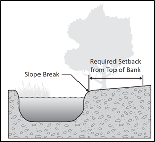
Figure 1--Measuring Stream Setbacks
(Ord. 544 (Att. A), 2025)
15.20.710 Reduction of setbacks.
Creek and stream setbacks may be reduced with approval by the city engineer when a study conducted by a qualified biologist or engineer, as applicable, makes a finding that a narrower setback:
A. Would not increase the potential for erosion (generally based on existing vegetation, soil and slope stability); and
B. Still encompasses the one-hundred-year floodplain; and
C. Fully protects riparian vegetation on the site (or may protect riparian vegetation through replanting on or off site); or
D. Is appropriate based on existing development near the stream in the vicinity; or
E. Is necessary to avoid a private property "taking";
F. Proposed new development within a creek/stream setback generally requires a landowner or developer to obtain a lake or streambed alteration agreement from the California Department of Fish and Wildlife.
When reduced setbacks are granted, design measures should be incorporated to protect riparian habitat by limiting the amount of clearing and fencing and/or locating such disturbances away from the stream. (Ord. 544 (Att. A), 2025)
15.20.720 Construction of roadways and infrastructure construction.
The number of road crossings for streams should be limited to the greatest extent possible.
A. Roadway crossings should be designed perpendicular to streams.
B. Culverts, piping, or lining intermittent or perennial streams by private entities is discouraged unless no feasible alternative exists. (Ord. 544 (Att. A), 2025)
Prior legislation: Ords. 269, 290 and 346.