


Chapter 9.59
Environmentally Sensitive Habitat Areas Protection and Preservation
Sections:
9.59.040 Application Requirements
9.59.050 Stream Conservation and Management
9.59.060 Wetland Conservation and Management
9.59.070 Project Review Procedures
9.59.080 Conservation Easements
9.59.090 Findings Required for Project Approval
9.59.100 Notice of Protection Combining Zone Overlay
9.59.010 Purpose
Environmentally sensitive habitat areas (ESHA) (Arcata Bay, tidal sloughs, estuaries, creeks, ponds, salt marshes, riparian corridors, wetlands, bird rookeries, shorebird concentration sites, Arcata Marsh and Wildlife Sanctuary, and diked/reclaimed former tidelands-Public Trust Lands) within the City are important natural resources that provide ecological balance, ecosystem function, biological productivity, and values such as wildlife habitat, water quality, open space and scenic resources, flood control , and opportunities for scientific study and education. Therefore, the requirements of this Chapter are intended to:
A. Protect the structure, composition, function and natural processes of ESHA to the same extent as occurs in the least-disturbed natural ecosystems in the City’s Planning Area;
B. Provide standards for development that will incorporate ESHA into the site design of proposed development without significant adverse impacts to these resources;
C. Ensure that any proposed subdivision, land use or development adjacent (within 250 feet) to or capable of affecting ESHA will not degrade these resources or diminish their structure, composition, function and natural processes; and
D. Ensure that legally created lots in ESHA contain a building site with minimum reduction necessary to the ESHA.
9.59.020 Applicability
A. The requirements of this Chapter apply to all ESHA and to adjoining properties (within 250 feet) whose proposed subdivision, land use or developments are capable of affecting these resources. No discretionary permit for development (within 250 feet) that may potentially affect ESHA will be issued except in compliance with all applicable requirements of this Chapter.
B. The requirements of this Chapter also apply to Environmental Buffer Areas (EBA). An EBA shall separate all permitted development from adjacent ESHA. The purpose of EBA is to prevent any degradation of the ecological functions provided by the ESHA as a result of adjacent development. The following shall apply to EBA:
1. The minimum width of the EBA for watercourses and wetlands shall be as provided in General Plan policies RC- 2 and RC-3, and Sections 9.59.050 and 060 respectfully.
2. The minimum EBA width for all other ESHA shall be 100 feet, unless the designated setback would eliminate all reasonable use of property.
C. The requirements of this Chapter shall apply in addition to the requirements of the primary zoning district and all other applicable provisions of this Land Use Code. Wherever these regulations conflict with or are inconsistent in application with any other regulation, the most protective of ESHA shall apply.
9.59.030 Definitions
Definitions of the technical terms and phrases used in this Chapter may be found in Article 10 (Glossary), under "ESHA."
9.59.040 Application Requirements
Where there is a question regarding the presence of an ESHA, its boundary location, or the applicable EBA dimensions in accordance with this Chapter, the public or private applicant shall provide the City with a Biological Assessment containing the following information:
A. A base map sufficient in scope to cover the ESHA and its EBA that delineates topographic elevations in (1 to 5 foot) intervals, roads, and all other structures, as applicable;
B. A vegetative map covering the base map area in sufficient detail to delineate all vegetative habitats present and to identify species that may indicate the presence and boundary of a ESHA as well as the occurrence of any listed species or species of concern;
C. A soil map delineating the location of hydric and non-hydric soils;
D. The top of bank for any protected watercourse (tidal water, estuary, stream or pond) will be located on the base topographic map and cross section(s) as identified by Figure 5-6, 5-7, or 5-8.
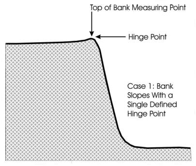
Figure 5-6 - Top of Bank Setback Measurement - Bank Slopes With a Single Defined Hinge Point
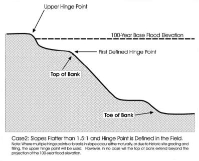
Figure 5-7 - Top of Bank Setback Measurement - Bank Slopes With Multiple Hinge Points
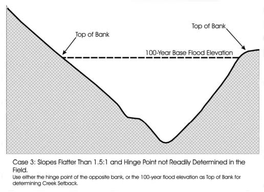
Figure 5-8 - Top of Bank Setback Measurement - Hinge Point Not Easily Defined
E. Wetlands delineation shall be based upon detailed field investigation of hydrology, soils and biota conducted by a qualified professional. The procedures for delineating wetlands are specified in the "Federal Manual for Identifying and Delineating Jurisdictional Wetlands, USACOE 1987." The City’s definition of wetlands utilizes a two-parameter protocol; a wetland includes those lands where two or more of the following characteristics are present, where one is a source of water (surface or subsurface) that is present for sufficient periods, and the second is to promote either the formation of hydric soils or growth of hydrophytic plant species. In the Coastal Zone, the presence of wetlands is presumed generally upon the presence of only one of the above parameters; wetland delineations shall be completed in accordance with the LCP.
F. Survey of wildlife species indicating the existence, or non existence, of an ESHA as well as the occurrence of any listed species or species of special concern;
G. The outward limit of the applicable EBA shall be indicated on the base topographic map for each ESHA.
H. An analysis of the ESHA’s existing and potential functions (physical, chemical and biological processes that characterize that ESHA) or its values (wildlife, habitat, flood control, open space or recreation) shall be provided.
I. An impact analysis of the proposed development shall be prepared that provides a mitigation and monitoring plan for all potential impacts to ESHA in compliance with Chapter 9.78 (environmental review procedures) and include the following:
1. Time of year that the project and mitigation measures will be implemented.
2. Description of each component of the proposed activities: access, grading, fill, construction, mitigation, monitoring, etc.
3. Description of proposed activities’ effect(s) to the ESHA.
4. Statement of measurable mitigation goals.
5. Description of feasible mitigation measures to avoid or reduce any proposed activities’ adverse effect(s).
6. On-site ESHA mitigation shall be greater than a 1:1 ratio.
7. Off-site ESHA mitigation ratio shall be a minimum of 2:1.
8. Description of the methods to be used to implement the mitigation measure, including drawings, maps, or illustrations necessary to adequately describe proposed mitigation.
9. Description of a mitigation monitoring plan to document that each mitigation measure has been implemented and that on an annual basis reports whether the goal has been successfully achieved for five years.
10. Description of remediation measures (contingency plan) that will be employed if at three years the mitigation has not achieved its goal.
11. Identification of ESHA restoration opportunities. (Ord. 1432, eff. 12/20/2013)
9.59.050 Stream Conservation and Management
Stream (to include all watercourses described in the General Plan Policy RC-1d and in Section 9.59.010) conservation and management shall enhance, maintain, and restore the biological integrity of entire watercourses (headwaters to mouth) and associated riparian habitat as natural features in the City’s landscape. The following requirements will apply to proposed development and new land uses on property within the Stream Protection combining zone (:SP) which encompasses the ESHA and its EBA that is shown on the Protected Watercourse Map of the Resource Conservation and Management Element of the General Plan (Figure RC-a).
A. The purpose of a :SP is for a watercourse and its EBA to remain in a natural state in order to protect watercourses and riparian habitat. Proposed development and new land use within a :SP may be restricted. The Director (Planning or Environmental Services) may authorize variable EBA widths as per General Plan Policy RC-2b to accommodate unique site conditions as long as the total EBA is greater than the area under a fixed EBA width (ex. 100' x 100' = 10,000 sq. ft. is the minimum EBA). Each :SP for a watercourse identified in the General Plan shall have the following dimensions, all measured perpendicular to the watercourse from the top of bank as defined in Article 10 (Glossary).
1. Existing developed areas. In stream reach areas (see amended exhibit RC-a, General Plan 2020) where existing development as defined in Article 10 (Glossary) is adjacent to a protected watercourse, the EBA shall extend a minimum of 25 feet outward on both sides of the watercourse, measured from the top of bank, or the area bounded by the FEMA Flood Zone A.
2. Undeveloped areas. In stream reach areas with no development (see amended exhibit RC-a, General Plan 2020) adjacent to a protected watercourse the EBA shall extend a minimum of 100 feet outward on both sides of the stream, measured from the top of bank, or the area bounded by the FEMA Flood Zone A, whichever is greater. The review authority may grant a variance, pursuant to State law, to reduce the 100 foot EBA width based on substantial evidence in the Biological Assessment and supported by written findings of compliance with the General Plan Resource Conservation Element.
3. Areas of significant riparian vegetation. On a site with significant areas of riparian vegetation exceeding 100 feet in width measured from the top of bank, the EBA shall be expanded to encompass all of the riparian vegetation, to a maximum of 250 feet from either side of the stream.
4. The City Engineer and the Environmental Services Director may reduce the EBA to less than 25 feet in association with stream "day lighting" (restoration) projects.
B. Allowable uses and activities within :SP shall sustain biological productivity (PRC 30230), protect against any significant disruption of habitat values (PRC 30240), and shall maintain or enhance the functional capacity (PRC 30233). Allowable land uses and activities within an :SP shall be limited to the following, in compliance with all other applicable requirements of this Chapter and the General Plan policies RC-1 and RC-2. Any proposed land use, development, or removal of vegetation that is not listed below shall be prohibited. For projects located within the coastal zone, refer to the City’s certified LCP.
1. Agricultural uses (including community gardens) determined to be compatible with maintenance of watercourse and riparian resources shall not exceed 50 percent of the setback area and not within 25 feet of the top of bank;
2. Fencing along property boundaries and along :SP boundaries to prevent bank erosion and degradation of natural riparian vegetation by livestock;
3. Maintenance of existing roads, driveways, and structures;
4. Construction of public road crossings;
5. Forest management practices as permitted by the State of California or Arcata’s Forest Management Plan;
6. Construction and maintenance of foot trails for public access on public lands;
7. Construction and maintenance of utility lines;
8. ESHA restoration and enhancement projects;
9. Emergency or preventive (where there is no feasible less environmentally damaging alternative), and where feasible mitigation measures have been provided to minimize adverse environmental effects (PRC 30233), removal of sediment and vegetation for flood control purposes when authorized by the City Environmental Services Director;
10. Construction of new detention basins shall not exceed 50 percent of the setback area and not within 25 feet of the top of bank;
11. Public coastal access improvements; and
12. Boat launching facilities.
13. Exceptions. If restrictions(s) in this Subsection would result in an undeveloped legal parcel, not on Public Trust Lands, created prior to the effective date of General Plan 2020, being made unusable in its entirety for any use allowed by the General Plan and this Land Use Code, exceptions to that restrictions(s) may be granted through Use Permit approval to allow a reasonable economic use of the parcel; provided, that there is no feasible less environmentally damaging alternative, and feasible mitigation measures have been provided to minimize adverse environmental effects (PRC 3023) of the proposed use. (Ord. 1432, eff. 12/20/2013)
9.59.060 Wetland Conservation and Management
Wetland conservation and management shall protect existing wetlands areas and maintain a standard of "no net loss" in area, function and value, promote restoration of degraded wetland areas, enhancement of wetland functions, and creation of additional wetland areas to replace historic losses. The following requirements will apply to proposed development and new land uses on property within the Wetland Protection Combining zone (:WP) which encompasses the ESHA and its EBA.
A. The purpose of the :WP is for a wetland and its EBA to remain in a natural state in order to protect wetland ecosystems by ensuring no net loss in area, function or value. Proposed development and new land uses within a :WP may be restricted. The Director (Planning or Environmental Services) may authorize variable EBA widths as per General Plan 2020 Policy RC-3c to accommodate unique site conditions as long as the total EBA area is greater than the area under a fixed EBA width (ex. 100’ x 100’ = 10,000 sq. ft. is the minimum EBA area). Each :WP shall have the following dimensions, all measured perpendicular to the wetland boundary as defined in Article 10 (Glossary).
1. Existing developed areas. In areas where existing development as defined in Article 10 (Glossary) is adjacent to a wetland that has been delineated in compliance with Section 9.59.040, the EBA shall extend a minimum of 50 feet upland of the wetland boundary.
2. Undeveloped areas. In all other locations within the City, the EBA shall extend a minimum of 100 feet upland of the wetland boundary.
3. Artificial wetlands. The EBA may range from zero to 50 feet for Stormwater Best Management Practices such as detention basins and treatment wetlands.
B. Allowable uses and activities within :WP shall sustain biological productivity (PRC 30230), protect against any significant disruption of habitat values (PRC 30240), and shall maintain or enhance functional capacity (PRC 30233). Allowable land uses and activities within a :WP shall be limited to the following items enumerated below, in compliance with all other applicable requirements of Chapter 9.59 and the General Plan policies RC-1 and RC-3. Any proposed land use, development, or removal of vegetation that is not listed below shall be prohibited.
1. ESHA restoration or enhancement projects;
2. Agricultural uses (including community gardens) determined compatible with maintenance of wetland resources and consistent with Resource Conservation Element policy RC-3l shall not exceed 50 percent of the setback area and not within 25 feet of the delineated wetland boundary;
3. Fencing along :WP boundaries to prevent degradation of wetlands by livestock;
4. Maintenance of existing roads, driveways, and structures;
5. Construction and maintenance of foot trails for public access on public lands;
6. Maintenance of drainage ditches when compatible with wetland function;
7. Minor modification of existing, serviceable structures; and
8. Construction of new detention basins shall not exceed 50 percent of the setback area and not within 25 feet of the delineated wetland boundary.
9. Exceptions. If restriction(s) in this Subsection would result in an undeveloped legal parcel, not on Public Trust lands, created prior to the effective date of General Plan 2020, being made unusable in its entirety for any use allowed by the General Plan and this Land Use Code, exceptions to that restriction(s) may be granted through Use Permit approval to allow a reasonable economic use of the parcel, provided that there is no feasible less environmentally damaging alternative, and feasible mitigation measures have been provided to minimize adverse environmental effects (PRC 30233) of the proposed use.
C. Mitigation measures. Appropriate mitigation measures shall be determined during the applicable discretionary review process, except that the Zoning Administrator shall determine appropriate mitigation measures in the event a discretionary review process does not apply.
1. "Net loss." Mitigation measures must result in "no net loss" in area and value of wetlands, at a replacement ratio of from 1:1 to 10:1 as determined by the review authority. Mitigation may consist of creating and maintaining a new wetland of equal or greater biological function and value than the wetland proposed to be filled, restoration of previously degraded wetlands, or enhancement of existing wetland areas. Off site wetland mitigation shall require a higher replacement ratio. For the sole purpose of restoration or enhancement projects, no net loss of area may be acceptable if a net benefit and function in value is achieved at the discretion of Environmental Services.
2. Minimum mitigation requirements. Diking, filling or dredging of a wetland that is otherwise in compliance with this Chapter, shall, at a minimum, require mitigation measures, a monitoring program, and adequate funding.
3. Ongoing stewardship. Dedication of the land identified in the site plan to a public agency, purchase, or other stewardship method which permanently restricts the use of the site to habitat and open space purposes, shall be required. The site shall be dedicated, purchased, or other stewardship agreed upon, and mitigation agreed upon, and mitigation funding shall be provided, prior to any permitted diking or filling.
9.59.070 Project Review Procedures
All development that may affect an ESHA shall be reviewed in compliance with Sections 9.59.020, "Applicability," and 9.59.040, "Application Requirements," as well as the following procedures, in addition to the other procedures required by this Land Use Code for any required discretionary permit.
A. Initiation. Upon receiving an application for an action subject to discretionary approval, the Zoning Administrator shall determine whether a Biological Assessment is required based on the location of the proposed action with respect to an ESHA.
1. For development outside the Coastal Zone and not requiring any permits other than Building Permits, this determination shall comply with Section 9.72.100 (Zoning Clearance).
2. For development within the Coastal Zone, the determination shall occur as part of the review of a Coastal Development Permit application in compliance with the City’s LCP.
B. Consultation. Prior to approval of an action subject of discretionary review that has the potential to affect an ESHA; the Department shall refer the Biological Assessment to and consult with the following:
1. Environmental Services Department Director.
2. California Coastal Commission (CCC), California Department of Fish and Game (CDFG), North Coast Regional Water Quality Control Board (NCRWQCB), U.S. Army Corps of Engineers (USACOE), U.S. Fish and Wildlife Service (USFWS), National Oceanic Atmospheric Administration (NOAA), or the National Resource Conservation Service (NRCS) as applicable and other affected agencies for review and comment.
3. The City’s Wetlands and Creeks Committee or its equivalent;
4. The City shall ask the CCC, CDFG, and NCRWQCB, to review the proposed project’s Biological Assessment and to recommend, within 21 days of the request, measures to mitigate ESHA disturbances. This time period may overlap with the environmental review process.
C. Conditions of Approval. The Department shall immediately forward any comments and recommendations to the applicant for their response.
1. A decision by the review authority concerning the boundary, location, current status (function and value) to the ESHA in question, and the proposed project’s potential impacts and required mitigation measures shall be based on the substantial evidence in the record and supported by written findings of compliance with Chapter 9.59 of this Code and the General Plan Resource Conservation Element.
2. The Department shall recommend an appropriate bond amount to ensure that the mitigation measures and monitoring are successfully carried out, or in the case of default the City will be able contract for their completion. (Ord. 1432, eff. 12/20/2013)
9.59.080 Conservation Easements
The dedication of a conservation easement, or equivalent deed restriction, encompassing the area within an :SP or :WP, shall be required as a condition of approval of any discretionary planning permit, including Design Review, when any portion of the project site falls within an :SP or :WP. The easement may be conveyed to the City, to another governmental agency which shall manage the easement to protect the ESHA’s functions, biological productivity, and values or to an appropriate non-profit entity approved by the review authority.
9.59.090 Findings Required for Project Approval
Discretionary approval for a project affecting an ESHA shall require that the review authority first make the following findings in addition to any other applicable findings required by this Land Use Code.
A. The proposed land use or development is in compliance with the policies of the General Plan, Local Coastal Program and regulations in the Land Use Code.
B. The proposed land use or development will not impair the ecological balance, ecosystem function, biological productivity, and values of the ESHA.
1. The proposed land use or development will not degrade the structure, composition, function or natural processes of ESHA to a level below that which occurs in the least-disturbed natural ecosystems in the City’s Planning Area;
2. The proposed land use or development has incorporated the ESHA into its site design and does not pose any significant adverse impacts to these resources.
3. The EBA adopted is sufficient in width to maintain the structure, composition, function and natural processes of the affected ESHA.
4. Where applicable, the development is a habitat enhancement project.
C. The proposed land use or development is being approved, because there is no feasible less environmentally damaging alternative, and where feasible mitigation measures have been provided to minimize adverse environmental effects and that any affected ESHA shall be maintained, enhanced, and where feasible restored.
9.59.100 Notice of Protection Combining Zone Overlay
Prior to the effective date of the discretionary approval for a project involving a ESHA, and prior to any action prerequisite to proceeding with a development, the applicant shall cause to be recorded, with the Humboldt County Recorder’s Office, a notice declaring the presence of the :SP or :WP combining Zone as applicable on the property. The notice shall be in a form prescribed by the City and shall contain information regarding the location and nature of the :SP or :WP combining Zone overlay, and any applicable restrictions. The notice shall be recorded at the expense of the applicant.