


Chapter 17.06
GENERAL RULES1
Sections:
17.06.010 Rules for Construction of Language.
17.06.020 Rules of Measurement.
17.06.030 Rules for Interpretation.
17.06.010 Rules for Construction of Language.
In addition to the general provisions of this title, the following rules of construction shall apply:
A. The particular controls the general.
B. Unless the context clearly indicates the contrary, the following conjunctions shall be interpreted as follows:
1. “And” indicates that all connected words or provisions shall apply.
2. “Or” indicates that the connected words or provisions may apply singly or in any combination.
3. “Either ... or” indicates that the connected words or provisions shall apply singly but not in combination.
C. References to departments, commissions, boards, or other offices are to those of the City of Carmel-by-the-Sea unless otherwise indicated.
D. References to a public official in the City is to that person who performs the function referred to and includes a designated deputy of such official.
E. All references to days are to calendar days unless otherwise indicated.
F. Section and section headings contained herein shall not be deemed to govern, limit, modify, or in any manner affect the scope, meaning, or intent of any section.
G. The words “activities” and “facilities” include any part thereof of the activity or facility.
H. “Director” means the Community Planning and Building Director or the Director’s designee. (Ord. 2004-02 § 1, 2004; Ord. 2004-01 § 1, 2004).
17.06.020 Rules of Measurement.
A. Purpose. This section explains how various measurements referenced in this title are to be calculated.
B. General Provisions.
1. Applicant Responsibility. For all calculations, the applicant shall be responsible for supplying drawings illustrating the measurements. These drawings shall be drawn to scale and shall be of sufficient detail to allow easy verification upon inspection by the Director.
2. Fractions. When calculations result in fractions, the results will be rounded as follows:
a. Minimum Requirements. When a regulation is expressed in terms of a minimum requirement, any fractional result will be rounded up to the next consecutive whole number. For example, if a minimum requirement of one tree for every 30 lineal feet is applied to a 50-foot strip, the resulting fraction of 1.37 is rounded up to two required trees.
b. Maximum Limits. When a regulation is expressed in terms of maximum limits, any fractional result will be rounded down to the next lower whole number. For example, if a maximum floor area limit for guesthouse is applied to a 7,500-square-foot lot, the resulting number of 422.5 is rounded down to 422 allowed square feet.
3. Measuring Distances. Distances shall be measured as follows:
a. Distances Are Measured Horizontally. When determining distances for setbacks and structure dimensions, all distances are measured along a horizontal plane from the appropriate line, edge of building, structure, storage area, parking area, or other object. These distances are not measured by following the topography or slope of the land.
b. Measurements Are Shortest Distance. When measuring a required distance, such as the minimum distance between a structure and a lot line, the measurement is made at the closest or shortest distance between the two objects. Exceptions are stated in subsection (B)(3)(c) of this section.
c. Measurement of Vehicle Stacking or Travel Areas. The minimum travel distance for vehicles, such as a garage-entrance setback, is measured down the center of the vehicle travel area. For example, curving driveways are measured along the center arc of the driveway.
C. Required Area for a Building Site.
1. Existing Buildings. The ground area needed for legal construction of a building at the time of construction shall be one building site. If the building could not be legally built on the same ground area at the present time, the building site shall be called a nonconforming building site.
2. Vacant Land. The land area required by the standards in the base zoning districts shall be a legal building site if the land area is a legal lot of record or if the land area was legally reconfigured in conformance with the Subdivision Map Act of the State and the provisions for subdivision or lot line adjustments established in Chapter 17.44 CMC, Subdivisions and Lot Line Adjustments.
3. Multiple Lots on One Building Site. The ground area of a building site may be comprised of more than one lot. The ground area of more than one lot may be required by existing or proposed buildings on a site pursuant to CMC 17.10.020(B). Each building site must retain a ground area and setbacks consistent with all provisions of this code. Each building site must be composed of original lots of record or composed of new lots legally reconfigured from original lots in conformance with the Subdivision Map Act of the State and the provisions for subdivision or lot line adjustments established in the municipal code.
D. Determining Buildable Area. For the purposes of calculating allowable building volume and floor area, the buildable area of a lot shall be the lot area, minus the following:
1. Continuous portions of the site, occupying at least 10 percent of the site area, with a slope greater than 30 percent (e.g., see steep slope areas in Figure I-2).
2. The “pole” of a flag lot;
3. Private access roads;
4. Those portions of a site qualifying as Environmentally Sensitive Habitat Areas (ESHA) as provided for in Article V of Chapter 17.20 CMC, Environmentally Sensitive Habitat Area Overlay District; and
5. Scenic, habitat, coastal access or conservation easements.
 Figure I-2: Buildable Area
E. Average Slope.
1. Average Slope. The average slope of a lot is calculated by subtracting the average elevation of the uphill lot line and the average elevation of the downhill lot line and dividing the sum by the average distance between the two lot lines. The average elevation of the uphill or downhill lot line is calculated by adding the elevations at the ends of the lot line and dividing by two.
2. Average Percent of Slope. The ratio between vertical and horizontal distances expressed in percent, the mathematical expression of which is based upon the formula below:
|
Vertical Distance |
X |
100 = Average Percent Slope |
|
Horizontal Distance |
 Figure I-3: Average Slope
F. Grades. “Existing grade” is the set of elevations representing the surface of the ground prior to grading, filling, or other site alterations for a project. On developed sites, as each topographic line passes beneath a building it shall be assumed to be a straight and level line for purposes of defining existing grade. Existing grade may also be referred to as natural grade (See Figure I-4).
On sites disturbed from previous grading or excavation activities, an approximation of preexisting conditions may be used as a reference for determining average or existing grade using grades on adjacent sites, retaining walls and prior survey maps. All such grade approximations shall require the concurrence of the Department and a determination that the resulting project complies with all requirements of the Zoning Ordinance, avoids large exposed cuts and unnatural topography and is consistent with R-1 design objectives.
“Average grade” is a horizontal line approximating the ground elevation through each building on a site, used for calculating the exterior volumes of buildings. Average grade is calculated separately for each building. Average grade is calculated in four steps:
1. Plot the ground level perimeter of the building on a topographic map of the site using one-foot contour intervals. Assign an elevation of “zero” for the lowest contour line that passes through the building perimeter.
2. For each contour line that intersects the building perimeter, draw a straight line through the building that connects the point of intersection to where the same contour line emerges from the building perimeter (see Figure I-4, below).
3. For each line drawn in Step 2, multiply its length by its elevation (above the “zero” contour line) and then sum all results.
4. Divide the sum from Step 3 by the sum of the lengths of all lines drawn. The resulting elevation above the “zero” contour line is extended as a horizontal line through the building as average grade.
Figure I-4: Existing Grade
G. Exterior Volume. The maximum allowable exterior volume is calculated by multiplying a volume factor in CMC 17.10.030(C) by the allowed base floor area, subject to the following:
1. Exterior volume is expressed in cubic feet and is measured from the exterior wall and roof surfaces of each building. The exterior volume of the building shall be based on the height of the exterior walls above both the average existing grade and the average final grade. Where the average grade line lies below a building, the exterior walls of the building are projected down to average grade to calculate its volume. Portions of a building located below average grade are excluded from exterior volume.
2. Exterior volume includes all dwellings, guesthouses, accessory dwelling units, garages, carports, chimneys, storage sheds, projecting windows and covered porches.
3. Exterior volume also includes the volumes in and under any attached or freestanding arbor or trellis and under that portion of any roof eave extending more than 18 inches from the face of any building.
4. Decks or balconies with a walking surface more than three feet above final grade shall count as exterior volume as measured from the deck surface to the top of any rail or enclosing wall. Any deck or balcony with a floor level less than three feet above final grade will be excluded from the volume total.
Figure I-5: Determining Exterior Volume
H. Determining Base Floor Area. The maximum allowable base floor area shall be calculated by multiplying the buildable area of the lot by the maximum percentage presented in the development standards for each zone.
I. Determining Floor Area Ratio. The floor area ratio shall be expressed as percentage of the buildable area of the parcel of land upon which the building rests. For above-ground spaces, floor area is measured at the exterior of the enclosing walls. For basement spaces, floor area is measured at the interior of the enclosing walls.
J. Resubdivided Corner Lots. Resubdivided corner lots are those created through a lot line adjustment by reorienting a lot line 90 degrees running between two adjacent original lots of record, one of which is located at the corner of a block and the other is adjacent to the corner lot and fronting on the same street. Each lot created by this action is considered a resubdivided corner lot for purposes of establishing front setbacks.
K. Determining Lot Coverage. The total ground area of a lot occupied by materials or improvements that cover the natural soil but which are outside the perimeter of structures that count as floor area. Lot coverage includes:
1. Fully permeable materials including gravel, spaced decking and exterior stairs. However, shredded bark, wood chips and similar materials used as mulch within fully landscaped areas are not counted as lot coverage;
2. Semi-permeable materials including sand-set bricks or pavers, garden walkways of small paving stones, and arbors; and
3. Impermeable materials including asphalt, concrete, decomposed granite, mortared brick and stone, unspaced decking and balconies at any level, garden walls, solariums, bridges, sheds not counted as floor area, ponds, hot tubs and swimming pools.
L. Measuring Height.
1. Measuring Building Height. The height of buildings shall be measured as the plumb vertical distance from existing or finished grade (whichever is more restrictive) to the highest point on the roof.
a. Flat Roof. The measurement is made to the highest point of the roof beams of the roof.
b. Mansard Roof. The measurement is made to the deck line of the roof.
c. Pitched or Hipped Roof. The measurement is made to the peak or gable of the roof.
Figure I-6: Measuring Building Height
2. Measuring Height of Other Structures. The height of other structures, such as fences, is the vertical distance from the ground level immediately under the structure to the top of a structure. Special measurement provisions are also provided below.
a. Retaining Walls and Fences. Retaining walls and fences on top of retaining walls are measured from the ground level on the lower side of the retaining wall.
Figure I-7: Retaining Walls and Fences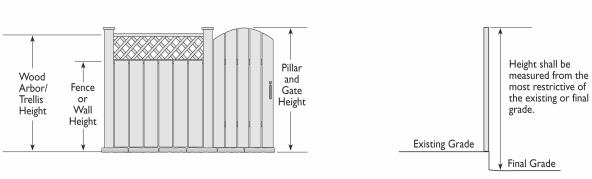
b. Decks. Deck height is determined by measuring from the ground to the top of the floor of the deck.
M. Measuring Lot Widths and Depths.
1. Lot Depth. The horizontal distance from the midpoint of the front lot line to the midpoint of the rear lot line or to the most distant point on any other lot line where there is no rear lot line.
2. Lot Width. The average horizontal distance between the side lot lines measured at right angles to the lot depth from the required front yard setback and from the required rear yard setback or from the rearmost point of the lot depth in cases where there is no rear lot line. The width of a nonrectangular lot shall be the mean length of the front and rear property lines.
N. Measuring Setbacks.
1. Front Setbacks. Front setbacks shall be measured from the property line adjacent to the street fronting the property. On corner lots with two street frontages, the shortest frontage shall be considered the front, regardless of where the driveway or front entry is located. See subsection (N)(5) of this section for flag lot exceptions.
2. Rear Setbacks. Rear setbacks shall be measured from the property line most directly opposite the front. See subsection (N)(5) of this section for flag lot exceptions.
3. Side Setbacks. Side setbacks shall be measured from the property lines not defined as front or rear.
4. Composite Side Setbacks. Composite side setbacks shall be calculated as the sum of both side setbacks. When calculating a composite side setback, any combination of the side setbacks may be used (for example a 10-foot composite side setback could be composed of five feet on both sides or three feet on one side and seven feet on the other). Different combinations may be used at different places on the site to allow for different building shapes. Composite side setbacks shall be measured along lines parallel to the front property line. On a flag lot the setback is measured along lines parallel to that line of the “flag” portion of the lot closest to the street.
5. Flag Lots. For flag lots, the front setback applies only to the first 15 feet of the “pole” near the street. All other setbacks apply to the “flag” portion. The “flag” portion will have two “rear” setbacks – one near (and perpendicular to) the pole and the other opposite to this. Setbacks on flag lots shall be measured by excluding the access strip or easement using only the bulk of the lot.
O. Measuring Sign Area. In computing the maximum permissible sign area or display surface, standard mathematical formulas for known or common shapes will be used. Brackets or other appurtenances incorporating design elements that are descriptive or informative of the business use shall be included as part of the sign area.
1. Multi-Faced Signs. All faces of a multi-faced sign shall be included in the calculation of area except for a double-faced hanging or monument sign, in which case only one face shall be included.
2. Irregularly Shaped Sign. The sign area shall include the smallest rectangle that wholly contains the sign. (Ord. 2017-10 § 2, 2017; Ord. 2004-02 § 1, 2004; Ord. 2004-01 § 1, 2004).
17.06.030 Rules for Interpretation.
A. Zoning Text. In the implementation of this title, the Director shall determine the intent of all provisions. The determination of the Director may be appealed in accordance with the provisions of Chapter 17.54 CMC, Appeals.
B. Zoning Map. The following rules shall apply to zoning boundary determinations:
1. District boundaries shown as approximately following the property line of a lot shall be construed to follow such property line.
2. Where a district boundary divides a lot, the location of the district boundary shall be determined by using the scale appearing on the zoning map or by the Director or the Planning Commission. This rule shall not apply to the AS overlay district.
3. Where the AS overlay boundary divides a building site, the entire building site shall be treated as within the overlay district.
4. District boundaries shown as approximately following right-of-way lines of streets or other identifiable boundary lines shall be construed to follow such right-of-way or boundary lines.
5. District boundaries shown as lying within right-of-way lines of streets, or other identifiable boundary lines shall be construed to follow the centerline of such right-of-way or boundary lines.
6. District boundaries shown as lying at the edge of a body of water shall be construed to follow the adopted 100-year floodplain identified for the watercourse.
C. Record of Interpretation. The Director shall keep a record of interpretations made pursuant to this section that shall be available to the public. (Ord. 2004-02 § 1, 2004; Ord. 2004-01 § 1, 2004).
Prior legislation: Code 1975 § 1302, Ords. 159 C.S., 80-23, 81-25, 82-12, 85-32, 88-24 and 89-17.