


Chapter 8.35
AIRPORT OVERLAY ZONING DISTRICT
8.35.010 Purpose and Intent.
The purpose and intent of the Airport Overlay Zoning District is to:
A. Implement the Airport Land Use Compatibility Plan (ALUCP) for the Livermore Municipal Airport in accordance with State Law and as adopted by the Alameda County Airport Land Use Commission (ALUC).
B. Implement the City’s General Plan policies to ensure that all proposed land uses within the Airport Influence Area (AIA) are consistent with the compatibility policies of the Airport Land Use Compatibility Plan (ALUCP) for the Livermore Municipal Airport.
C. Protect land uses around the airport from potential hazards related to airport operations.
D. Identify a range of uses compatible with potential airport accident hazard and airport noise exposure.
E. Prohibit the development of incompatible uses that are detrimental to the general health, safety and welfare and to existing and future airport operations.
F. Require noise attenuated construction within the airport environs.
G. Comply with Federal Aviation Administration (FAA) regulations. Ord. 19-14 (September 2014)
8.35.020 Definitions.
For purposes of these regulations, certain words or phrases shall be interpreted as set forth in this Chapter unless it is apparent from the context that a different meaning is intended. Where any of the definitions of this Chapter may conflict with the definitions in Chapter 8.08 (Definitions) of the Dublin Zoning Ordinance, the definitions in this chapter (Airport Overlay Zoning District) shall prevail for the purposes of this Chapter.
A. Definitions (A-Z)
Airport Influence Area (AIA). The area in which current or future airport-related noise, overflight, safety and/or airspace protection factors may significantly affect land uses or necessitate restrictions on those uses. The Airport Influence Area is designated by the Airport Land Use Commission (ALUC) as its planning area boundary for the airport and the two terms can be considered synonymous.
Airport Land Use Commission (ALUC). A commission authorized under the provisions of the California Public Utilities Code Sections 21670 et seq. and established, in any county within which a public-use airport is located, for the purpose of promoting compatibility between airports and the land uses surrounding them.
Airport Land Use Compatibility Plan (ALUCP). A plan adopted by the Airport Land Use Commission (ALUC) which sets forth policies for promoting compatibility between airports and the land uses which surround them. This plan is sometimes referred to as an Airport Land Use Policy Plan (ALUPP).
Airport Protection Area (APA). An area within the Airport Influence Area (AIA) established to prevent the encroachment of incompatible land uses near the vicinity of the Livermore Municipal Airport.
Existing Land Use. A land use that either physically exists or else for which government approvals have been obtained through one or more of the following:
1. A valid building permit has been issued;
2. A legally valid development agreement has been approved and remains in effect pursuant to Government Code Section 65864 et seq. which provides that, “A development agreement shall specify duration of the agreement, the permitted uses of the property, the density or intensity of use, the maximum height and size of proposed buildings and provisions for reservation or dedication of land for public purposes”;
3. A tentative parcel or tract map has been approved and the original period, excluding extensions, has not expired;
4. A vesting tentative parcel or tract map has been approved, pursuant to Government Code Section 66498.1(b) which “confer a vested right to proceed with development standards in effect at the time the vesting tentative map is approved or conditionally approved”;
5. A parcel or final map has been recorded; or
6. A use permit, planned unit development or Planned Development zoning indicating the permitted uses of the property, the density or intensity of use, the maximum height and size of proposed buildings and provisions for reservation or dedication of land for public purposes that has been approved and not yet expired.
Helipad. A small, designated area, usually with a prepared surface, on a heliport, airport, landing/take-off area, apron/ramp, or movement area used for take-off, landing or parking of helicopters.
Heliport. A facility used for operating, basing, housing, and maintaining helicopters.
Hospitals. Any facility other than a private physician’s office or outpatient clinic, in which care is offered to individuals who exhibit physical, emotional, or mental disability or illness. Examples include acute care hospitals, freestanding emergency rooms, nursing homes, board and care facilities, birthing centers, mental institutions and rehabilitation centers.
Hotels and Motels. Any structure or facility intended or suitable for short-term occupancy by persons as a temporary dwelling. Examples include hotels, motels, bed and breakfast inns, youth hostels, pensions, and temporary shelters.
Multifamily Residential (land use). Any project, development or other land use in which separate families or individuals occupy dwelling units which share a common wall or a common roof, or occupy a common legal parcel of real estate. Examples include duplexes, triplexes, quadriplexes, apartment buildings, condominiums, townhouses and residential courts. In addition, institutional uses such as hospitals, nursing homes, board and care facilities, correctional institutions and boarding schools, which entail the long-term occupancy of a single structure by unrelated individuals are considered multifamily residential.
Nonconforming Use. An Existing Land Use that does not conform to an adopted or subsequently amended airport land use compatibility plan.
Office Buildings (land use). Any development, regardless of structure size, which includes significant floor space suitable for use by personnel performing or providing clerical, professional, or financial services as a primary use. The presence of limited office space for support of another primary function is not considered an office building under this definition.
Redevelopment. Construction of a new use (though this does not have to be a new land use type) to replace an Existing Land Use at a density or intensity that may differ from the existing use.
Single-Family Residential (land use). The use of land for dwellings in such manner that no more than one primary dwelling unit is developed on each legal parcel and the size of each legal parcel is less than one acre. Ord. 19-14 (September 2014)
8.35.030 Applicability.
The Airport Overlay Zoning District shall apply to all lands within the Airport Overlay Zone mapped on the official Zoning Map. The Airport Overlay Zone is coterminous with the Livermore Municipal Airport, Airport Influence Area (AIA) as identified in Figure 3-1 and described in Section 3.1.1 of Chapter 3 of the adopted Livermore Municipal Airport ALUCP (August 2012).
The Airport Overlay Zoning District is a designation in addition to the Planned Development (PD) Zoning District designation that each property in the Airport Overlay Zoning District retains. The PD Zoning District ordinance for each property contains all the information regarding permitted and conditionally permitted uses and development standards and regulations while the Airport Overlay Zoning District provides a mechanism to review land uses within the District for consistency with the ALUCP for the Livermore Municipal Airport.
All permitted and conditionally permitted uses set forth in a PD Zoning District that was adopted and in effect prior to August 2012 shall be deemed Existing Land Uses pursuant to the Livermore Municipal Airport ALUCP. The Alameda County ALUC has no authority over Existing Land Uses unless changes to an Existing Land Use results in an increase of nonconformity with ALUCP policies and the change would increase the intensity or density of the use beyond what was permitted by the Existing Land Use (Reference: ALUCP Chapter 2, Section 2.7.5.7(b)). Ord. 19-14 (September 2014)
8.35.040 Projects Subject to Compliance with this Chapter.
A. Projects Subject to Review by the Airport Land Use Commission (ALUC). The following land use actions shall be reviewed by the Airport Land Use Commission (ALUC) for compliance with the Livermore Municipal Airport ALUCP prior to approval by the City (Reference: ALUCP, Chapter 2, Section 2.6.1):
1. General Plan or Specific Plan Amendments. General Plan or Specific Plan Amendments that propose new land uses or increase the intensity or density of Existing Land Uses within the Airport Influence Area (AIA). Existing Land Uses are defined in Section 8.35.020.A (Definitions A-Z).
2. Zoning Ordinance Amendments. Zoning Ordinance Amendments that:
a. Introduce a new land use (i.e. Use Type) within the AIA not contemplated by an Existing Land Use; or
b. Increase the intensity or density of, or permitted by, an Existing Land Use within the AIA; or
c. Involve any of the following airport-related concerns:
1. Exposure to aircraft noise;
2. Exposure of persons on the ground to accident potential;
3. Creation of obstructions to air navigation; or
4. Creation of hazards to flight such as wildlife hazards, smoke, flare, lighting, electrical interference and thermal plumes.
3. Redevelopment. Redevelopment of a property that:
a. Replaces an Existing Land Use with a new use; or
b. Increases the intensity or density of, or permitted by, an Existing Land Use which is consistent with the General Plan and/or Specific Plan but does not conform to the compatibility criteria set forth in the Livermore Municipal Airport ALUCP.
4. Airport and Heliport Plans. Any proposal for a new airport, heliport or helipad, for public or private use, if the facility requires a State Airport Permit and any proposal to expand an existing airport or heliport that is not included in an approved master plan for the airport or heliport and such expansion will require an amendment to a State Airport Permit.
B. Projects Subject to Review by the City. All ministerial actions and all discretionary actions shall be reviewed by the City for compliance with the Livermore Municipal Airport ALUCP and this Chapter prior to approval.
1. Ministerial Actions. Projects subject to a ministerial action including, but not limited to, Business License applications, Building Permit applications, Zoning Clearance applications and Site Development Review Waivers shall document compliance with Section 8.35.050 (Development Regulations) prior to approval.
a. Exceptions to Ministerial Actions. The following ministerial actions shall be exempt from the requirements of this Chapter:
1. Business License applications for out of town businesses, home occupations, change of owner or business name, and daily/itinerant business licenses.
2. Building permit applications for projects subject to a discretionary action where compliance has already been documented as part of the discretionary action.
3. All other Building Permit applications except for Commercial Alterations.
4. Zoning Clearance applications for temporary promotional signs.
5. Zoning Clearance applications for permanent signs when limited to wall signs only.
6. Temporary Use Permit applications.
7. Heritage Tree Removal applications.
2. Discretionary Actions. Projects subject to a discretionary action, including but not limited to General Plan Amendments, Specific Plans and Specific Plan Amendments, Zoning Ordinance Amendments, Site Development Review Permits, Tentative Maps, Variances, Conditional Use Permits and Minor Use Permits, shall document compliance with Section 8.35.050 (Development Regulations) and all required findings for the applicable discretionary action in addition to those in Section 8.35.060.C (Required Findings) shall be made prior to approval of the project.
3. Referral. If, during the course of review of any ministerial or discretionary action, the City identifies potential airport related concerns, the Community Development Director has the authority to require that the project be referred to the Airport Land Use Commission for review. Ord. 19-14 (September 2014)
8.35.050 Development Regulations.
Projects subject to compliance with this Chapter shall comply with the compatibility policies and criteria for airport related noise, public safety, airspace protection and aircraft overflight as set forth in Section 3.3 of the Livermore Municipal Airport ALUCP (August 2012).
A. Airport Related Noise. Noise compatibility standards are intended to prevent the establishment of noise-sensitive land uses in portions of the airport environ that are exposed to significant levels of aircraft noise. Where permitted within the Airport Influence Area (AIA), the following noise-sensitive land uses shall comply with applicable noise exposure criteria.
1. Interior Noise Levels Not to Exceed 45 dB CNEL. For the following noise-sensitive land uses, aircraft-related, interior noise levels shall not exceed 45 dB CNEL (with windows closed):
a. Living or sleeping areas of single or multi-family residences;
b. Hotels and motels;
c. Hospitals and nursing homes;
d. Place of Worship, meeting halls, and mortuaries; and
e. Schools, libraries and museums.
2. Interior Noise Levels Not to Exceed 50 dB CNEL. For the following noise-sensitive land uses, aircraft-related, interior noise levels shall not exceed 50 dB CNEL (with windows closed):
a. Office environments;
b. Eating and drinking establishments; and
c. Other miscellaneous commercial facilities.
B. Public Safety. Land use compatibility standards are intended to minimize the risk to people and property on the ground as well as to people in an aircraft in the event of an accident or emergency landing occurring outside the airport boundary.
1. Airport Influence Area (AIA). The following land uses have been determined by the ALUCP to have a high risk of exposing persons to airport-related safety hazards and are therefore prohibited within the AIA and the Airport Overlay Zone:
a. Field and stalk crops;
b. Dry farm and grain;
c. Forest reserves; and
d. Fish and game reserves.
The following land uses have been determined by the ALUCP to be “conditional” within the AIA. “Conditional” means that the uses may be compatible with airport operations depending on their location, size, bulk, height, density and intensity of use. Refer to Sections 3.3.2.8 and 3.3.2.9 of the Livermore Municipal Airport ALUCP (August 2012) for conditional criteria.
a. Medium to large indoor assembly (≥300 <1,000 people);
b. Waterways (rivers, creeks, swamps, bays, lakes);
c. Reservoirs, quarry lakes, detention ponds, aquifer recharge, recycled water storage, flood control or water conveyance channels; and
d. Water treatment.
2. Airport Influence Area (AIA), Safety Zone 6. The following land uses have been determined by the ALUCP to have a high risk of exposing persons to airport-related safety hazards and are therefore prohibited in those portions of the AIA and Airport Overlay Zone identified as “Zone 6: Traffic Pattern Zone.” Refer to Figure 35-1.
a. Schools (K-12);
b. High capacity indoor assembly (≥1,000 people);
c. Large outdoor assembly (≥1,000 people);
d. Orchards;
e. Power plants; and
f. Golf courses.
The following land uses have been determined by the ALUCP to be “conditional” within those portions of the AIA identified as “Zone 6: Traffic Pattern Zone.” Refer to Figure 35-1. “Conditional” means that the uses may be compatible with airport operations depending on their location, size, bulk, height, density and intensity of use. Refer to Sections 3.3.2.8 and 3.3.2.9 of the Livermore Municipal Airport ALUCP (August 2012) for conditional criteria.
a. Commercial daycare (≥6);
b. Inpatient facilities (i.e. hospitals, health care facilities, nonambulatory medical centers, sanitariums, psychiatric facilities);
c. Congregate care facilities, ambulatory and nonambulatory (i.e. assisted living, convalescent, rehabilitation facilities, retirement homes);
d. Correctional facilities;
e. Low capacity indoor assembly (≤300 people); and
f. Vineyards.
3. Airport Influence Area (AIA), Safety Zone 7. The following land uses have been determined by the ALUCP to be “conditional” within those portions of the AIA identified as “Zone 7: Area between Zone 6 and the AIA boundary.” Refer to Figure 35-1. “Conditional” means that the uses may be compatible with airport operations depending on their location, size, bulk, height, density and intensity of use. Refer to Sections 3.3.2.8 and 3.3.2.9 of the Livermore Municipal Airport ALUCP (August 2012) for conditional criteria.
a. High capacity indoor assembly (≥1,000 people);
b. Medium to large indoor assembly (≥300 <1,000 people);
c. Large outdoor assembly (≥1,000 people);
d. Waterways (rivers, creeks, swamps, bays, lakes);
e. Reservoirs, quarry lakes, detention ponds, aquifer recharge, recycled water storage, flood control or water conveyance channels;
f. Water treatment;
g. Power plants; and
h. Golf courses.
4. Airport Protection Area (APA). The Airport Protection Area (APA) is an area within the Airport Influence Area (AIA) that has been established to prevent the encroachment of incompatible land uses near the Livermore Municipal Airport. Refer to Figure 35-1. The following land uses have been determined by the ALUCP to have a high risk of exposing persons to airport-related safety hazards and are therefore prohibited within the APA:
a. Single family residential;
b. Multifamily residential;
c. Hotels and motels; and
d. Long term lodging (i.e. dormitories, etc.).
5. Uses Considered “Conditional.” Uses considered “conditional” may be compatible with airport operations depending on their location, size, bulk, height, density and intensity of use. The primary measure of risk exposure, for people on the ground in the event of an aircraft accident, is the number of people concentrated in a single area. Applications, whether ministerial or discretionary, to establish uses considered “conditional” shall be referred to the Alameda County ALUC for an advisory review. The ALUC will identify any design or locational strategies that could reduce or avoid harm to those on the ground resulting from a potential aircraft accident.
Table 1: Figure 35-1 Airport Overlay Zone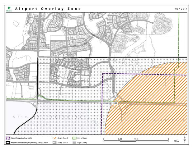
C. Airspace Protection. Airspace protection standards are intended to reduce the risk of harm to people and property resulting from an aircraft accident by preventing the creation of land use features that can be hazards to the airspace used by aircraft in flight.
1. Federal Aviation Administration (FAA) Review. The following airspace protection standards shall apply to all projects regardless of whether they are proposed within or outside of the Airport Influence Area (AIA).
a. Proponents of a project shall notify the FAA if a proposed structure may exceed 1 foot in height for every 100 feet from the edge of the nearest runway for a distance up to 20,000 feet.
b. Proponents of a project shall notify the FAA if a proposed structure is more than 200 feet above ground level at its site.
2. Other Flight Hazards. The following specific characteristics shall be avoided within the Airport Influence Area (AIA):
a. Glare or distracting lights that could be mistaken for airport lights;
b. Sources of dust, heat, steam, or smoke that may impair pilot vision;
c. Sources of steam or other emissions that may cause thermal plumes or other forms of unstable air that generate turbulence within the flight path;
d. Sources of electrical interference with aircraft communications or navigation; and
e. Features that create an increased attraction for wildlife.
D. Aircraft Overflight. Aircraft overflight standards are intended to provide overflight notification for land uses near the Livermore Municipal Airport. It shall be the responsibility of all owners of property offered for sale or for lease within the Airport Overlay Zoning District to provide the following disclosure prior to selling or leasing property in Dublin:
NOTICE OF AIRPORT IN VICINITY
This property is presently located in the vicinity of an airport, within what is known as an airport influence area. For that reason, the property may be subject to some of the annoyances or inconveniences associated with proximity to airport operations (for example: noise, vibration, or odors). Individual sensitivities to those annoyances can vary from person to person. You may wish to consider what airport annoyances, if any, are associated with the property before you complete your purchase or lease and determine whether they are acceptable to you.
All discretionary actions shall include a condition of approval requiring all owners of property offered for sale or for lease within the Airport Overlay Zoning District to provide the aforementioned disclosure prior to selling or leasing property. For new residential land uses, the overflight notification shall be recorded and appear with the property deed. Ord. 19-14 (September 2014)
8.35.060 Procedures.
A. Approval. All ministerial and discretionary actions within the Airport Overlay Zoning District, unless otherwise exempted in Section 8.35.040.B.1.a (Exceptions to Ministerial Actions), shall be reviewed for consistency with the Livermore Municipal Airport ALUCP and this Chapter prior to approval.
Projects listed in Section 8.35.040.A (Projects Subject to Review by the Airport Land Use Commission (ALUC)) shall be referred to the Airport Land Use Commission (ALUC) for a determination of consistency prior to approval.
Uses listed in Section 8.35.050.B (Public Safety) as “conditional” shall be referred to the Airport Land Use Commission (ALUC) for advisory review prior to approval.
B. Overrule Provisions. Should the Alameda County ALUC deem a project inconsistent with the Livermore Municipal Airport ALUCP, the City Council may, pursuant to Public Utilities Code Section 21676(b), overrule the ALUC.
C. Required Findings. Notwithstanding subsection B of this section, when a project within the Airport Overlay Zoning District is also subject to approval of a discretionary action, the following additional findings shall all be made prior to approving the project:
1. The project complies with the noise compatibility policies of the Livermore Municipal Airport ALUCP.
2. The project complies with the safety compatibility policies of the Livermore Municipal Airport ALUCP.
3. The project complies with the airspace protection policies of the Livermore Municipal Airport ALUCP.
4. The project complies with the overflight policies of the Livermore Municipal Airport ALUCP. Ord. 19-14 (September 2014)