


DIVISION III. PROPERTY DEVELOPMENT AND USE REGULATIONS
Chapter 13-30. Property Development Standards
Sec. 13-30.100 Purpose and Applicability.
The purpose of this Division and Chapter is to provide land use, development regulations and standards that are generally applicable to sites throughout the City. Unless noted otherwise, these standards are intended to be applied within all zoning and overlay districts.
Specific development standards or performance standards required within particular zoning and overlay districts are required in addition to the general standards required within this Division. If there is a conflict between regulations and standards specified for a particular zoning district and the general standards contained within this Title, the district specific regulations and standards shall be applied.
All development permits, design review approvals, planned development plans, use permits and other zoning approvals, as conditioned, shall be consistent with the regulations and standards contained within this Division. The Community Development Director along with the Building Official and City Engineer shall review all building permit plans and improvement plans for compliance with this Division prior to approval of such plans. Prior to issuance of a certificate of occupancy, projects shall be inspected by the Community Development Director along with the City Engineer to verify that the standards of this Division and any required conditions of approval have been adequately met. [Ord. 515 § 2, 2018; ZO § 30.100.]
Sec. 13-30.200 Setbacks and Yards.
The yard space provided about any structure as a yard or setback in compliance with the regulations for the district in which the property it is located shall not be allowed to provide a yard space for any other structure. Required yard spaces and setbacks are identified within the property development regulations of each zoning district and some overlay districts. [Ord. 515 § 2, 2018; ZO § 30.200.]
Sec. 13-30.210 Setback and Yard Measurement.
Setbacks and yards shall be measured as the minimum horizontal distance from the property line of the site to a line parallel with the front, side or rear face of a building. [Ord. 515 § 2, 2018; ZO § 30.210.]
Sec. 13-30.220 Allowed Projections into Setbacks and Yards.
Architectural features including bay windows, sills, canopies, chimneys, cornices and eaves may extend into a required side yard or a space between structures not more than 24 inches and may extend into a required front or rear yard not more than 3 feet.
Open, unenclosed, uncovered balconies, porches, platforms, stairways, and landing places, no part of which is more than 4 feet above the surface of the ground, may extend into a required side yard or space between structures not more than 3 feet and may extend into a required front or rear yard not more than 6 feet.
Fire escapes may project into rear and interior side yards or spaces between buildings not more than 3 feet.
Fences, walls, hedges, walks, driveways and retaining walls may occupy any required yard or other open space, subject to the limitations prescribed in this Chapter.
No structure or projection may intrude into a public utility easement. [Ord. 515 § 2, 2018; ZO § 30.220.]
Sec. 13-30.300 Coverage and Floor Area Ratio (FAR).
The amount of site coverage and FAR allowed for a building or buildings within a zoning district or overlay district is identified within the property development regulations of the district. [Ord. 515 § 2, 2018; ZO § 30.300.]
Sec. 13-30.310 Coverage and Floor Area Ratio Measurement.
The percent of the site area covered by structures shall be measured by dividing the total horizontal area covered by structures open or enclosed by the total horizontal area within the property lines of the site.
The floor area ratio of a site shall be measured by dividing the total usable floor area of structures on the site, excluding areas used exclusively for vehicle parking and circulation, by the total horizontal area within the property lines of the site. [Ord. 515 § 2, 2018; ZO § 30.310.]
Sec. 13-30.320 Coverage and Floor Area Ratio Exemptions.
The City may consider allowing development agreements that will provide additional community parks and recreation facilities, such as ballfields and other areas for organized recreation, in exchange for allowing development at greater than the “typical” FAR, as specified in the property development regulations of some zoning districts. [Ord. 515 § 2, 2018; ZO § 30.320.]
Sec. 13-30.400 Residential Density.
The residential density allowed within residential and mixed-use zoning districts is identified within the property development regulations of the district. New development shall not exceed maximum allowed residential densities unless there are specific regulations allowing density bonuses that are granted for a project by the City Council. The midrange density specified within the residential zoning districts is meant to be a general guide for the average density expected across the community for all property within that particular zoning district.
The density of residential development allowed on any parcel within the City should take into account site specific considerations including but not limited to, topography, economics, neighborhood compatibility, provision of affordable housing, and market conditions along with the capability of a proposed development project to further the specific goals, policies and objectives of the General Plan. [Ord. 515 § 2, 2018; ZO § 30.400.]
Sec. 13-30.410 Residential Density Calculation.
Residential density is calculated as a gross density for all residential units within a property or planned development plan area. Gross density is calculated by dividing the total number of units by the total area of the site including roads, open spaces and public facilities. The minimum lot size represents the maximum net density for single-family attached and detached homes. [Ord. 515 § 2, 2018; ZO § 30.410.]
Sec. 13-30.420 Residential Density Bonuses—Purpose and Applicability.
1. This Section through Section 13-30.440 and the requirements of California Government Code Sections 65915 through 65918, as may be amended, are intended to implement the housing element of the General Plan offering incentives for the development of affordable housing. Where regulations are not specifically addressed in these sections or where there are conflicts between these provisions and the provisions of California Government Code Sections 65915 through 65918, the provisions of the California Government Code, as they may be amended over time, shall apply. [Ord. 551 § 2, 2024; Ord. 515 § 2, 2018; Ord. 484 § 12, 2015; ZO § 30.420.]
Sec. 13-30.430 Residential Density Bonuses—Application Requirements.
1. An applicant may submit a preliminary proposal for housing development pursuant to California’s Density Bonus Law, including but not limited to Government Code Section 65915, prior to the submittal of any formal application.
2. All requests pursuant to California’s Density Bonus Law, including but not limited to Government Code Section 65915, shall be submitted to the City concurrently with the application for the first discretionary permit or other permit required for the housing development and shall be processed concurrently with the discretionary application following the review process as set forth for permits in Chapters 13-40 and 13-42, design review (when applicable). The applicant shall provide additional information as specified in California’s Density Bonus Law, including but not limited to Government Code Section 65915, specifically:
A. Provide a written statement specifying the desired density increase, incentives and any waivers requested; proposed rent schedules and/or sales prices; and the type, location, size, and construction scheduling of all dwelling units;
B. Submit sufficient evidence demonstrating that the requested incentive(s)/concession(s) result in actual and identifiable cost reductions;
C. For any requested waiver of a development standard, evidence that the development standard for which the waiver is requested will have the effect of physically precluding the construction of the housing development with the density bonus and incentives requested;
D. If a mixed-use building or project is proposed as an incentive, evidence that nonresidential land uses will reduce the cost of the housing development and that the nonresidential land uses are compatible with the development and the existing or planned development in the area;
E. If a density bonus is requested for a land donation, the location of the land to be dedicated, proof of site control, and evidence that each of the requirements included in California’s Density Bonus Law, including but not limited to Government Code Section 65915 can be met.
F. If a density bonus or incentive is requested for a child care facility, evidence that all of the requirements in California’s Density Bonus Law, including but not limited to Government Code Section 65915, can be met.
G. Any other information requested by the Community Development Director or their designee to determine if the required findings can be made. [Ord. 551 § 2, 2024; Ord. 515 § 2, 2018; Ord. 484 § 12, 2015; ZO § 30.460. Formerly 13-30.460.]
Sec. 13-30.440 Residential Density Bonuses—Findings.
1. Before approving an application that includes a request for a density bonus, incentive, parking reduction, and/or waiver pursuant to California’s Density Bonus Law, including but not limited to Government Code Section 65915, the decision-making body shall make all of the following findings, as applicable:
A. That the residential project is eligible for the density bonus and any incentives, parking reductions, or waivers requested.
B. That any requested incentive will result in identifiable, financially sufficient, and actual cost reductions based upon the financial analysis and documentation provided.
C. That there are sufficient provisions to guarantee that the units will remain affordable for the required time period.
D. If the density bonus is based all or in part on donation of land, a finding that all the requirements included in California’s Density Bonus Law, including but not limited to Government Code Section 65915, have been met.
E. If the density bonus, concession, or incentive is based all or in part on the inclusion of a child care facility, a finding that all the requirements included in California’s Density Bonus Law, including but not limited to Government Code Section 65915, have been met.
F. If the concession or incentive includes mixed-use development, a finding that all the requirements included in California’s Density Bonus Law, including but not limited to Government Code Section 65915, have been met.
G. If a waiver is requested, a finding that the development standards for which the waiver is requested would have the effect of physically precluding the construction of the housing development with the density bonus and incentives permitted.
2. If the findings required by subsection (1) of this Section cannot be made, the City Council may deny an application for a concession or incentive only if it makes 1 of the following written findings, supported by substantial evidence:
A. The concession or incentive does not result in identifiable and actual cost reductions, consistent with Government Code Section 65915(k), to provide for affordable housing costs, as defined in Section 50052.5 of the Health and Safety Code, or for rents for the targeted units to be set as specified in Government Code Section 65915(c); or
B. The concession or incentive would have a specific, adverse impact, as defined in Government Code paragraph (2) of subdivision (d) of Section 65589.5, upon public health and safety or on real property listed in the California Register of Historic Resources, and there is no feasible method to satisfactorily mitigate or avoid the specific adverse impact without rendering the development unaffordable to low and moderate income households; or
C. The concession or incentive is contrary to State or Federal law.
3. If the findings required by subsection (1) of this Section cannot be made, the City Council may deny an application for a waiver only if it makes 1 of the following written findings, supported by substantial evidence:
A. The waiver or reduction of development standards has a specific, adverse impact as defined in Government Code Section 65589.5(d.2), upon health and safety and for which there is no feasible method to satisfactorily mitigate or avoid the specific, adverse impact; or
B. The waiver or reduction of development standards has a specific, adverse impact on any real property that is listed in the California Register of Historical Resources; or
C. The waiver is contrary to State or Federal law.
4. If the findings required by subsection (1) of this Section can be made, the decision-making body may deny an application for a density bonus or incentive that is based on the provision of child care only if it makes a written finding, based on substantial evidence, that adequate child care facilities are already available in the City. [Ord. 551 § 2, 2024; Ord. 515 § 2, 2018; Ord. 484 § 12, 2015; ZO § 30.470. Formerly 13-30.470.]
Sec. 13-30.450 Residential Density Bonuses—General Requirements.
Repealed by Ord. 551. [Ord. 515 § 2, 2018; Ord. 484 § 12, 2015; ZO § 30.450.]
Sec. 13-30.500 Height Limits.
Required height limits are identified within the property development regulations of each zoning district and some overlay districts. [Ord. 515 § 2, 2018; ZO § 30.500.]
Sec. 13-30.510 Height Measurement.
The height of a structure shall be measured vertically from the average elevation of the surface of the ground covered by the structure to the highest point of the structure or to the wall coping of a flat roof or to the deck line of a mansard roof. Heights of a fence or wall shall be measured according to the requirements of Section 13-30.610. [Ord. 515 § 2, 2018; ZO § 30.510.]
Sec. 13-30.520 Height Limitation Exceptions.
1. Towers, spires, cupolas, chimneys, water tanks, flagpoles, monuments, radio and television aerials, fire towers, windmills or other energy generating devices, and similar structures, and necessary mechanical appurtenances covering not more 10 percent of the ground area covered by the structure, may be erected to a height not more than 25 feet above the height limit prescribed by the regulations for the district in which the site is located subject to design review as provided in Chapter 13-42 and subject to securing a use permit in each case.
2. Utility poles and utility towers installed by public utility shall not be subject to height limits prescribed in the district regulations. [Ord. 515 § 2, 2018; ZO § 30.520.]
Sec. 13-30.600 Fences, Walls and Hedges.
Walls, fences and hedges are permitted in all zoning districts and may be placed within required yard areas subject to the regulations and performance standards of the district and applicable overlay districts. [Ord. 515 § 2, 2018; ZO § 30.600.]
Sec. 13-30.610 Fence, Wall and Hedge Height.
1. The maximum height for a fence, wall or hedge in a required rear or side yard is 6 feet. The maximum height for a fence, wall or hedge in a required front yard and along the street side yard of a corner lot within 20 feet of the front property line is 3 feet.
2. The height of a fence, wall or hedge shall be measured from the highest natural ground level immediately adjoining the fence wall or hedge to the its highest point above the ground.
3. A fence wall or hedge greater than 6 feet in height may be allowed in the following conditions subject to first securing design review approval as per Chapter 13-42.
A. A fence, wall or hedge up to 12 feet in height may be permitted around public recreation areas such as tennis courts, badminton courts, basketball or volleyball courts and similar play areas; provided, that all parts of a fence or wall over 6 feet in height are made of open wire construction of galvanized steel or other corrosion resistant material, and that the fence, wall or hedge is not within any required front yard.
B. School play areas may be fenced to the street line; provided, that the fence is made of open wire construction and does not exceed 10 feet in height along rear and side lot lines and does not exceed 6 feet in height along any street line.
C. A fence, wall or hedge that is not constructed within any required rear, side or front yard and which is a continuation of a building wall may be higher than 6 feet when it is an extension of the roof of the primary building and does not exceed in height the building wall of which it is an extension.
D. A security fence, wall or hedge exceeding 6 feet in height around industrial or manufacturing establishments or other uses may be allowed where required for security purposes in any zoning district other than residential and community commercial.
E. Where residential properties abut a railroad right-of-way, fences of solid board or similar materials may be constructed to a height not to exceed 8 feet in the side or rear yards abutting the railroad right-of-way.
4. Where a commercial or industrial site adjoins a residential district, a solid fence or wall, a vine-covered chain-link fence with slats, or a compact evergreen hedge, not less than 6 feet nor more than 8 feet in height, shall be located on the property line adjoining the residential district. However, the fence, wall or hedge shall not exceed 3 feet in height when it is adjacent to a required front yard in a residential district.
5. Screening consisting of a solid fence or wall, a vine-covered chain-link fence with slats, or a compact evergreen hedge (with solid gates where necessary), not less than 6 feet in height, shall be required for the following uses:
A. Commercial and industrial uses within commercial, industrial, and mixed-use districts that are not conducted entirely within a completely enclosed structure where the Commission or Council finds that screening is necessary to a substantial and detrimental effect on property values in the area.
B. Open storage of materials and equipment within commercial, industrial, and mixed-use districts. No materials or equipment shall be stored outside without such screening and to a height no greater than that of the fence, wall or hedge.
C. Loading facilities equipment within commercial, and mixed-use districts. Such facilities shall be screened from view from public rights-of-way.
6. A fence or wall may be constructed on the rear property line of a lot that has frontage on 2 public streets (with a rear yard adjacent to a public street which is approximately parallel to the front yard street) where the rear yard has restricted access due to a legally dedicated reserve strip. The rear fence or wall, not exceeding 6 feet in height, shall be constructed of masonry or similar type construction or a compact evergreen hedge (with solid gates where necessary). The property owner shall install an irrigation system and landscaping approved by the Director of Public Works within the reserve strip as a condition of issuance of the fence or wall permit. The irrigation system and planting in the reserve strip will then be maintained by the City of Hercules. This provision does not alter the requirements for lower fencing at intersections as provided in subsection (7) of this Section.
7. No fence, wall or hedge which obstructs the visibility of and from vehicles approaching the intersection of a state highway, public road or street with another state highway, public road or street shall be constructed, grown, maintained or permitted higher than 3 feet above the curb grade within 35 feet of the intersection of curb lines or in the case of rounded corners, 35 feet from the point on the curb closest to the center of the intersection. If there are no curbs, the edge of the right-of-way shall be used for the reference points.
8. Prohibited Fences. The following type fences are prohibited and hereby declared to be a nuisance constituting an unsafe and unlawful condition subject to abatement.
A. Barbed wire fences within 4 feet of any sidewalk.
B. Wire fences less than 3 feet in height and within 3 feet of any public sidewalk. [Ord. 515 § 2, 2018; ZO § 30.610.]
Sec. 13-30.700 Landscaped Areas.
Landscaping is an essential component of the overall design and aesthetics of a project. Landscaping along major regional streets and highways should soften the appearance of traffic and parking along these routes, while allowing view corridors to retail and other businesses.
Landscaping plans should implement effective water conservation, use of drought-resistant landscaping and irrigation with reclaimed wastewater. Native plants are to be used in landscaping.
Plantings that serve to screen views of residential development, or that help to maintain a natural-appearing landscape, shall be retained to the extent feasible. Such plants could be thinned selectively if thinning would improve view corridors. If specific trees are to be removed, such as eucalyptus trees, replace with trees, preferably native species that will provide suitable screening while retaining important view corridors.
1. The landscaping and irrigation requirements listed in this Section shall apply to all proposed development or construction at undeveloped parcels, or as determined by the Community Development Director, which shall include but not be limited to the following developments:
A. Common areas and landscape easements of all single-family subdivisions.
B. All new single-family residential estate lots.
C. Common areas at multifamily residences, including apartment and condominiums and duets.
D. Model homes.
E. Commercial, industrial and mixed-use projects.
F. Public buildings, grounds and facilities.
G. The reconstruction or rehabilitation of the common areas and landscape easements at residential projects and nonresidential buildings, projects or developments where either:
1) The value of the reconstruction or rehabilitation exceeds 25 percent of the current assessed value of the building, project or development; or
2) The area of the landscaping affected by the reconstruction or rehabilitation exceeds 25 percent of the landscaped area.
The requirements do not apply to that portion of a site, or to projects or development using reclaimed water or well water, or additions or modifications to existing single-family residences, nor to portions of site area irrigating edible crops, or not receiving irrigation.
2. Landscaping and irrigation shall be installed and maintained according to the approved plan. All water in the common areas of a development project used ornamentally, such as ponds, lakes and fountains, shall be supplied, operated and maintained with alternative sources of water if they are available. The landscaping and irrigation plan shall implement the following standards:
A. Plant Selection. At least 75 percent of the plants proposed in nonturf areas shall be well-suited to the climate of the region and require minimal water once established. Up to 25 percent of the plants may be of a nondrought tolerant variety as long as they are grouped together and can be irrigated separately.
B. Turf Area and Water Surface Area Limitations: The combined turf area and/or water surface area (i.e. pools, ponds and fountains) shall be limited to 25 percent of the irrigated areas. Exceptions may be granted by the Planning Commission when using drought-tolerant turfgrasses (i.e., with a water requirement less than or equal to tall fescue). Turf area and/or water surface area limitation does not apply to public parks, golf courses, cemeteries, school recreation areas, and on-site private recreational facilities. No turf shall be allowed in:
1) Median strips.
2) Areas less than 8 feet wide.
C. Soil Conditioning and Mulching.
1) Scarify soil compacted by grading prior to planting.
2) A minimum of 6 cubic yards of nitrified soil conditioner per 1,000 square feet shall be incorporated into the top 6 inches of soil.
3) A minimum of 2 inches of mulch shall be added in nonturf areas to the soil surface after planting. Nonporous material shall not be placed under the mulch.
4) Soil tests showing soil type, soil depth, uniformity and pH shall be submitted with landscape plans. Soil will be amended according to report recommendations.
5) Grading shall be minimized to avoid disturbance. Top soil shall be stockpiled and shall be reapplied during final grading.
6) Use low-nitrogen, slow release fertilizer for lawns and shrubs.
D. Irrigation.
1) Sprinklers and sprays shall not be used in areas less than 8 feet wide.
2) Sprinkler heads with a precipitation rate of 0.85 inches per hour or less shall be used on slopes exceeding 15 percent or on slopes exceeding 10 percent within 10 feet of hardscapes to minimize runoff.
3) Valves and circuits shall be separated based on water use.
4) Drip or bubbler irrigation systems are required for trees. Bubblers shall be used that do not exceed 1.5 gallons per minute per device.
5) Sprinkler heads must have matched precipitation rates within each control valve circuit.
6) Popup sprinklers in lawn areas shall have at least a 4-inch popup height.
7) Check valves are required where elevation differences may cause low head drainage.
8) Sprinkler head spacing shall be designed for head-to-head coverage. The system should be designed for minimum runoff and overspray onto nonirrigated areas.
9) Electrical controllers shall be set to water between 5:00 p.m. and 10:00 a.m.
10) All irrigation systems shall be equipped with a controller capable of dual or multiple programming. Controllers must have multiple cycle start capacity and a flexible calendar program.
11) All irrigation systems shall be equipped with rain shutoff devices.
12) Plans shall include a water budget that includes:
A) Estimated annual water use (in gallons).
B) Irrigated area (in square feet).
C) A monthly irrigation schedule for the plant establishment period and the following year. This irrigation schedule will include the following information for each valve:
(1) Plant type.
(2) Precipitation rate.
(3) Run times in minutes per day.
(4) Number of watering days per week (turfgrasses should be irrigated a maximum of once every 3 days).
E. Minor modifications to approved plans (including changes proposed by individual homeowners to approved plans for single-family subdivisions) which meet the requirements of this Section may be approved by the Community Development Director as per Chapter 13-46.
F. Minor exceptions from the requirements of this Section may be approved as part of the design review process; provided, that the Planning Commission finds the landscape and irrigation plans meet the intent these requirements. See Chapter 13-45.
3. Maintenance of Landscaped Areas. Landscaping provided in compliance with this Section shall be planted with materials suitable for screening or ornamenting the site, whichever is appropriate, and plant materials shall be watered, weeded, pruned, fertilized, sprayed or otherwise maintained as needed or required by the Planning Commission. Landscaping shall be replaced as necessary to provide the approved and required screening or ornamentation of the site. [Ord. 515 § 2, 2018; ZO § 30.700.]
Sec. 13-30.750 Paving Within Residential Front, Rear, and Side Yard Areas.
The requirements specified in this Section are intended to preserve the residential character of streetscapes in the City’s neighborhoods and minimize excess stormwater runoff. The unregulated expansion of paved parking areas in front, rear, and side yards interferes with the pattern of building and open areas within neighborhoods, and can increase vehicle clutter by creating small parking lots in yard areas which are intended to remain as open areas.
Excessive paving of yard areas can negatively impact the character and appearance of residential areas. Paving yard areas to add additional parking can result in the proliferation of curb cuts that can have the effect of reducing the number of on-street parking spaces available.
1. The paving requirements in this Section shall apply to all residential properties and lots.
2. New paving and hardscape areas (e.g., walkways, patios, etc.) that exceed 120 square feet in total area shall require a paving permit issued in compliance with Section 13-5.700, Zoning Clearance Procedure.
3. The Planning Director shall hear and decide requests for reasonable accommodation as well as unique circumstances of flag lots, cul-de-sacs, or corner lots which make strict compliance with the requirements of this Section impractical.
4. Within 6 months of final passage of the ordinance codified in this Section, staff shall promulgate administrative guidelines and regulations further defining what types of surfaces and materials are permissible for landscaping, paving, driveways, and walkways consistent with this Division.
A. Front Yards.
1) Driveways. The amount of allowable paving for driveways shall not exceed 35 percent of the total front yard area. “Front yard” is defined as the yard area forward of the primary structure as illustrated in Figure 13-30.751 (Limits on Paving and Hardscaping for Residential Front, Rear, and Side Yards).
2) Walkways and Other Hardscape. The amount of paved walkways and hardscape shall not exceed 25 percent of the front yard area. See Figure 13-30.751 (Limits on Paving and Hardscaping for Residential Front, Rear, and Side Yards).
3) Landscaping Minimums. For all residential properties, a minimum of 40 percent of the front yard area shall consist of a permeable landscaped area, excluding pavers, bricks, and other hard surfaces, even if permeable.
B. Rear and Side Yards.
1) The total amount of paved surface in the rear and side yard combined for driveways, walkways, and hardscape combined shall not exceed 60 percent of the total rear yard area. “Rear and side yard” are defined as the yard area behind the front portion of the primary structure as illustrated in Figure 13-30.751 (Limits on Paving and Hardscaping for Residential Front, Rear, and Side Yards).
2) Landscaping Minimums. For all residential properties and lots, a minimum of 40 percent of the required rear and side yard combined area shall consist of a permeable landscaped area, excluding pavers, bricks, and other hard surfaces, even if permeable.
C. Stormwater Runoff Limitations. Impermeable surfacing may not exceed the stormwater runoff design for the parcel or lot, and must not cause runoff to affect adjacent property. Applicants in the RS-L Residential Zone shall be required to submit to the City Engineer calculations by a registered civil engineer demonstrating consistency with this policy as a condition of approval when the impermeable surfacing, including all structures, would be greater than 47 percent of the entire lot. For all other residential zones, the City Engineer shall require applicants to submit calculations by a registered civil engineer demonstrating consistency with this policy as a condition of approval based on administrative regulations promulgated by staff to address stormwater runoff in zones other than RS-L. The administrative regulations required to be promulgated pursuant to this subsection shall be established within 1 year of final passage of the ordinance codified in this Section and updated thereafter as circumstances require.
Figure 13-30.751 (Limits on Paving and Hardscaping for Residential Front, Rear, and Side Yards)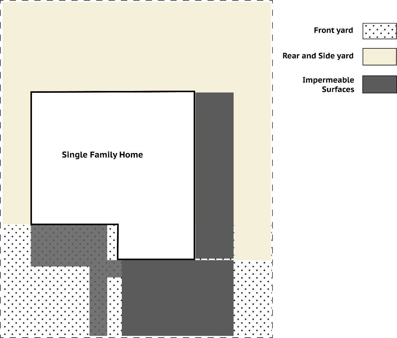
[Ord. 515 § 2, 2018; Ord. 511 § 2, 2018; ZO § 30.750.]
Sec. 13-30.800 Open Space.
1. Usable Open Space. Usable open space is required within several zoning districts to serve residents, visitors and employees of a project or property. Usable open is distinct from required landscaped areas in that the open space is to be specifically designed for use rather than aesthetics. Where usable open space is required within a zoning district, it shall be in addition to any landscaping requirement and public parks requirement. Usable open space may be provided in the form of small play areas, plazas, balconies, decks, usable yard areas, open space trails, or other similar spaces. The minimum usable open space area is 50 square feet of contiguous area not less than 5 feet wide in any location. Open space trails shall not provide more than 50 percent of the usable open space requirement of a project.
2. Open Space for Public and Conservation Uses. Public and conservation oriented open spaces provide public access to natural, scenic and historic areas; protect sensitive environmental areas, and provide protection and buffers from safety hazards. These open spaces offer amenities that benefit the quality of life in the community; preserve existing natural topography, ridgelines and valleys where feasible and desirable; preserve foraging habitat for wildlife; and provide for wetlands mitigation, flood control improvements and riparian corridors.
Open spaces should be planned for a buffer of irrigated landscaping and/or plowed area maintained between open spaces and developed areas, fire access trails in major open spaces to allow fire equipment to penetrate, use of fire resistant plant materials in open space landscaping, and containment of potential fires where natural vegetation exists in open spaces.
A. Wetlands mitigation, flood control improvements and riparian corridors should not be used in the calculation of required park space, parks, or recreational areas. However, the City may accept such areas in the calculation of required park space if they are accessible to the general public for use and enjoyment.
B. Areas that could provide habitat for sensitive species shall be surveyed by qualified biologists provided by project sponsors prior to project design. Surveys in sensitive areas shall be conducted prior to any development. Sensitive areas within the study area includes eucalyptus groves, freshwater wetlands and adjacent trees, open grasslands, ponds and creeks. If any sensitive species are present, coordination with the CDFG will be required for mitigation of impacts and redesigning of the project footprint to avoid any sensitive species or sensitive habitat. If avoidance is unavailable, coordination with the CDFG will be required for relocation of these species and for determining replacement of habitat.
C. As much open space as possible within sites proposed for development shall be retained as informal open space for wildlife habitat, rather than as formal, landscaped parks or grounds. Wildlife areas shall be revegetated with native or nonnative grassland and native species of shrubs requiring no irrigation and little management beyond the first year after planting. Wildlife habitat shall be consolidated into “preserves” that are as large as possible. Habitats on adjoining parcels shall be as contiguous as possible, to create wildlife corridors. Wildlife open space shall be placed adjacent to other wildlife habitat, to preserve the greatest ecological value.
D. Appropriate buffer zones along the Bay shall be established in consultation with CDFG, BCDC, East Bay Regional Park District, and the Corps of Engineers to protect tidal habitat when designing a bay access trail linkage between Pinole and Rodeo. Public access and pedestrian pathways shall be limited within the buffer zone, and when possible, located along the edges of the buffer zone. Signage and fencing shall be designed to encourage bicycles to stay on the bike paths.
E. Public access to wildlife habitat shall be minimized by placing trails close to buildings so as to provide the largest area of habitat possible with the least amount of impact from the public. Trails, if any, shall be placed close to buildings so as not to disturb wildlife nesting/denning areas.
F. Open space areas shall be designed into the footprint of proposed projects and shall be located adjacent to existing open space areas, providing a larger continuous area for wildlife to use.
G. Open space areas, if disturbed during construction, shall be landscaped with native species. [Ord. 515 § 2, 2018; ZO § 30.800.]
Sec. 13-30.900 Public Facilities.
All discretionary land use approvals shall be conditioned upon payment of fees or construction of facilities necessary to serve all public infrastructure needs generated by the new development. Public infrastructure shall include, but not be limited to the following: local and regional transportation improvements; parks and recreation facilities; open space; wastewater collection, treatment and disposal capacity; drainage and flood control facilities; schools; and utilities.
New public infrastructure facilities and other associated improvements shall be designed and constructed according to the procedures and standards of the City. [Ord. 515 § 2, 2018; ZO § 30.900.]
Sec. 13-30.910 Access, Circulation and Streets.
All structures and uses shall have adequate access to public streets. Access can be provided by means of accessible frontage along public streets or permanent public, private or reciprocal easements that provide adequate access to public streets.
Street rights-of-way and improvements are to be dedicated by projects as necessary to provide adequate internal circulation and external access. New residential areas shall be designed to avoid conflict with major streets or thoroughfares, to have access to transit facilities, and to encourage safe and convenient alternatives to the private automobile.
Developers of new residential areas are encouraged to work with transit agencies in the design and location of bus stops, turnouts, pavement materials and the timing of development in relation to transit service needs. To promote safe and well-designed neighborhoods, new residential development is to have an internal circulation system, including pedestrian walkways, bikeways, and access to transit facilities.
New streets, paths and sidewalks are to be designed and constructed according to the procedures and standards of the Director of Public Works. See Standard Drawings and Design Policy for Public Works. [Ord. 515 § 2, 2018; ZO § 30.910.]