


Chapter 7.17 Grading, Retaining Walls, and Hardscape Standards
7.17.10 Purpose of this Chapter
The purpose of this Chapter is to establish performance standards, development standards and the findings required for the modification of any applicable development standard for grading, retaining walls, and hardscape development. For purposes of this Chapter, grading refers to both rough grading and permanent grading. Rough grading is defined as any activity, including earthworks, that disturbs the existing ground surface through earth movement. Permanent Grading is defined as grading that results in a permanent alteration of the land surface that remains in place after development. Therefore, both rough grading and permanent grading, as used hereafter, include the construction of all retaining walls and hardscape surfaces.
7.17.20 Applicability of this Chapter
Appendix Chapter J of Title 26 of the Los Angeles County Code, amended and in effect on January 1, 2008, which constitutes an amended version of the California Building Code, 2007 Edition, is hereby adopted by reference as the Grading Code of the City of La Habra Heights. A copy of the Grading Code has been deposited in the office of the City Clerk of the City of La Habra Heights and shall be at all times maintained by the City Clerk for use and examination by the public. Unless otherwise noted, this Chapter applies to all grading, retaining walls, and hardscape development in the City of La Habra Heights regardless of the Zone District. A Grading Permit and Haul Route Permit are required under the provisions of this Chapter. Permit application procedures are identified in Article 8. (Ord. 2008-02 § 2 (Exh. A))
7.17.30 Performance Standards for Grading, Retaining Walls and Hardscape
All new development and modifications to existing structures must adhere to the City’s grading, retaining walls, and hardscape performance standards designed to maintain community character, privacy, views and public health and safety.
A. Natural Topography. Grading shall be undertaken in such a manner as to minimally affect the appearance of visible natural topography, surroundings and ridgelines, while still respecting appropriate uses, including agricultural uses.
B. Environmental Impacts. Grading shall be conducted in such a manner as to minimize the impacts of the development on community character, including agricultural uses, the surrounding neighborhood, and any natural features.
C. Site Drainage. Grading, retaining walls, and hardscape shall be implemented such that natural storm water and other drainage courses are preserved in their existing location and elevation or changed and enhanced without a negative impact on surrounding properties, the natural appearance of the site or upon community or neighborhood character.
D. Natural Landforms. Grading that results in an alteration of the land surface that remains in place after development shall be minimized and natural landforms, including ridgelines, preserved. Grading shall be used to conform the structures to the site and shall feature grading techniques that mimic natural landforms. Where possible, grading shall rely upon natural-appearing development areas at differing elevations to avoid visible, graded pads that extend substantially beyond the use area or structure footprint.
E. Placement of Building Pads. Grading shall be limited to that necessary for the primary structure, accessory structures and uses and for access. Accessory structures and uses shall be placed at varying distances and elevations from the primary structure, where practical, to minimize the size of the graded pad, eliminate the creation of unnatural linear features, and preserve the natural topography.
F. Views. Grading and earthworks otherwise unnecessary shall not be conducted solely to provide or enhance views from the project site.
G. Landscaping. Measures shall be implemented on all graded surfaces immediately after grading to prevent erosion. Permanent landscaping shall be installed as soon as feasible to preserve community character and to control erosion. Landscaping, which may include, trees, shrubs and ground covers, shall be utilized immediately after grading or prior to the next rainy season to stabilize and hide all graded areas. All landscaping used for erosion control must be maintained and irrigated.
H. Erosion. All grading shall utilize interim protection during grading activities and permanent protection thereafter against erosion of soil onto adjacent roads or other property. (Ord. 2015-01 §§ 29)
7.17.40 Development Standards for Grading, Retaining Walls and Hardscape
The following development standards implement the goals and policies of the La Habra Heights General Plan related to grading, retaining walls and hardscape.
A. Selection of Development Site. Where there are multiple developable areas within a lot, grading shall be limited to those areas that have the least adverse impact on the natural surroundings, including ridgelines. Development applications shall identify what alternative graded areas were considered and those determined to have the least adverse impact on the natural surroundings. Development application procedures are identified in Article 8.
B. Allowable Maximum Permanent Graded and Hardscape Areas. Allowable permanent graded and hardscape area standards depend upon the size of the parcel as shown in Exhibit 7-13. Permanent graded or hardscape areas include areas such as driveways in accordance with the provisions of this Chapter. Up to one thousand (1,000) square feet of a pool area capable of accepting at least three-quarters (3/4) of an inch of additional water shall not be considered hardscape and shall not be counted towards hardscape area.
1. With an approved standards modification, agricultural grading for orchards, groves or other agricultural plantings, which does not use retaining walls and is otherwise in conformance with the grading standards of this Chapter applicable to accessory uses, may be excluded in determining permanent graded area.
2. In order to utilize the exclusion provided in subsection (B)(1) of this section, a permanent restrictive covenant, requiring that the designated area be limited in use to agricultural purposes only, must be recorded in the Office of the County Recorder against the property.
|
ALLOWABLE MAXIMUM PERMANENT GRADED AND HARDSCAPE AREAS |
||
|---|---|---|
|
MAXIMUM GRADED AREA |
||
|
Less than 0.5 acre = |
|
10,000 sq. ft. |
|
Greater than 0.5 acres = |
|
If footprint is over 4,000 square feet: 12,000 sq. ft. + (4,000 sq. ft. * (area in acres -1)) + (footprint - 4,000) |
|
|
|
If footprint is less 4,000 square feet: 10,000 sq. ft. |
|
MAXIMUM HARDSCAPE AREA |
||
|
Less than 0.5 acre = |
|
Maximum graded area minus 4,000 square feet |
|
Greater than 0.5 = |
|
Maximum graded area minus 4,000 square feet |
Exhibit 7-13. Allowable Maximum Permanent Graded and Hardscape Areas
C. Size Limit on Retaining Walls and Slopes. The height, length and visible extent of graded slopes and retaining walls are limited to preserve community character. Allowable dimensions of such walls and slopes are limited by the purpose of the wall or slope. Retaining walls and slopes are not allowed except to implement development of the lot for its primary and accessory uses and structures. The height and length of any such wall or slope is defined as that which is visible (refer to Exhibits 7-14, 7-15, 7-16 and 7-17) as shown in Table 7-10.
|
Use/Type |
Cut Slopes |
Fill Slopes |
Retaining Wall (cut) |
Retaining Wall (fill) |
|---|---|---|---|---|
|
Retaining Wall or Slope Creating Area for Primary Structure (refer to Exhibits 7-14 and 7-15) |
||||
|
Maximum total height of all walls and slopes for primary structure |
Lesser of height of structure or 20 ft.1. |
Lesser of height of structure or 20 ft.1. |
Lesser of height of structure or 20 ft.1. |
Lesser of height of structure or 20 ft.1. |
|
Maximum total length of all walls and slopes for primary structure |
Total width of structure parallel to slope plus 40 ft. |
Total width of structure parallel to slope plus 40 ft. |
Total width of structure parallel to wall plus 40 ft. |
Total width of structure parallel to wall plus 40 ft. |
|
Retaining Wall or Slope Creating Area for Accessory Structure (refer to Exhibits 7-14 and 7-15) |
||||
|
Maximum total height of all walls and slopes for accessory structures |
Lesser of height of structure or 12 ft.1. |
Lesser of height of structure or 12 ft.1. |
Lesser of height of structure or 12 ft.1. |
Lesser of height of structure or 12 ft.1. |
|
Maximum total length of all walls and slopes for accessory structures |
Total width of structure parallel to slope plus 20 ft. |
Total width of structure parallel to slope plus 20 ft. |
Total width of structure parallel to wall plus 20 ft. |
Total width of structure parallel to wall plus 20 ft. |
|
Retaining Wall or Slope Creating Area for Accessory Use (refer to Exhibits 7-14 and 7-15)4. |
||||
|
Maximum total height of all walls and slopes for accessory uses |
Eight (8) feet |
Eight (8) feet |
Eight (8) feet |
Eight (8) feet |
|
Maximum total length of all walls and slopes for accessory uses |
Total width of use parallel to slope plus 12 ft. |
Total width of use parallel to slope plus 12 ft. |
Total width of structure parallel to wall plus 12 ft. |
Total width of structure parallel to wall plus 12 ft. |
|
Slope Steepness Limits (refer to Exhibit 7-16) |
||||
|
Maximum slope. |
Maximum of 2 to 1. |
Maximum of 2 to 1. |
Maximum of 2 to 1 between walls |
Maximum of 2 to 1 between walls |
|
Minimum Slope Boundary Radii (refer to Exhibit 7-17) |
||||
|
Minimum top of slope curvature radius: |
Five (5) feet |
Five (5) feet |
NA |
NA |
|
Minimum bottom of slope curvature radius: |
Five (5) feet |
Twenty Five (25) feet |
NA |
NA |
|
Minimum edge of slope curvature radius: |
Five (5) feet |
Twenty Five (25) feet |
Five (5) feet |
NA |
|
Landscaping Requirements for Erosion Control and Screening of Slopes and Walls |
||||
|
Erosion control measures required upon completion of wall or slope. |
100% of surface |
100% of surface |
100% of disturbed area |
100% of disturbed area |
|
Landscape screening standards to achieve within three years following completion of project.3. |
75% of visible surface. |
75% of surface area. |
75% of visible surface. |
75% of visible surface. |
|
1. Measured to the double plate or top of full-width wall section. 2. Modification allowed per UBC.3. Landscape planting must be installed over the entire slope. 4. For purposes of this Chapter, guest houses are considered accessory structures. |
||||
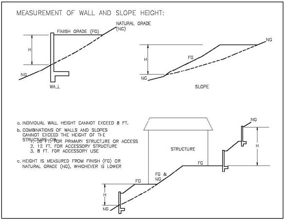
Exhibit 7-14. Measurement of Wall and Slope Heights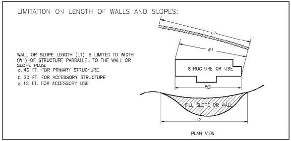
Exhibit 7-15. Measurement and Limits on Wall and Slope Lengths
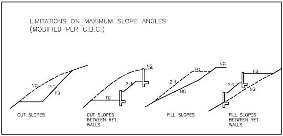
Exhibit 7.16 Limitations on Maximum Slope Angles
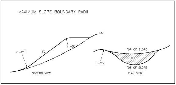
Exhibit 7-17. Minimum Slope Boundary Radii
D. Landform Contour Grading. Contour grading shall be utilized to mimic the look of natural topography. Typical contour grading features include variable slope angles and undulating top and toe of fill lines. These features are shown in Exhibit 7-18.
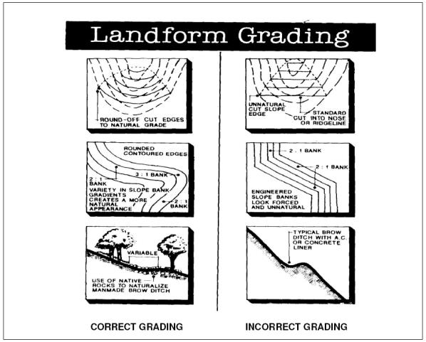
Exhibit 7-18. Contour Grading Concept
E. Gradable Area. Any additional grading on a site that has been previously graded shall require a Standards Modification in the event the total cumulative graded area exceeds the maximum permitted (refer to Exhibit 7-13).
F. Other Development Standards for Cut Slopes, Fill Slopes and Retaining Walls. The following development standards are applicable to cut slopes, fill slopes, and retaining walls:
1. Retaining walls up to three (3) feet may be allowed in the public right of way (ROW) with an approved Encroachment Permit, Grading Permit, and a Haul Permit where applicable. The procedures for obtaining these permits are identified in Article 8. The retaining walls shall be setback from the edge of the roadway pavement by at least five (5) feet.
2. No individual retaining wall shall have a visible section greater than eight (8) feet in height except for walls required for access to the ROW.
3. Fences, garden walls or safety fences on top of retaining walls not used for driveways are allowed but shall be setback at least three (3) feet from top of the retaining wall. Fences, garden walls or safety fences need not be setback from the top of retaining walls protecting a cut below grade if the retaining wall faces the property interior (Exhibit 7-19). Safety fences on top of driveway retaining walls are not required to be setback if such setback would require additional grading to provide the required width.
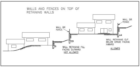
Exhibit 7-19. Fences on Top of Retaining Walls
4. For staggered retaining wall systems, the next higher wall shall be separated from the next lower wall by at least one and one-half times the visible height of the taller wall. The separation space shall be landscaped (refer to Exhibit 7-20).
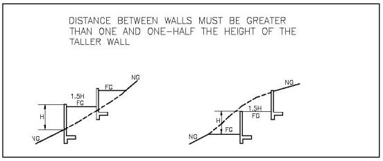
Exhibit 7-20. Minimum Distances Between walls
5. Structure walls must conform to all pertinent provisions of the Uniform Building Code as they apply to development setbacks from the toe and top of slopes.
6. Junctions between different use retaining walls and/or graded slopes must display horizontal and vertical offsets of at least five (5) feet and be screened using landscaping adequate to obscure the entire junction to minimize visibility of large linear or planar surfaces from other public or private property.
7. The minimum setback distance of any portion of any cut or fill or retaining wall from any property line, except for those required for access from right-of-way, is three (3) times its visible height at that point but not more than the applicable baseline setback.
8. No structures or grading may be constructed within twenty (20) feet of the high water line of a designated blue line stream or storm water drainage channel. Lesser setbacks may be permitted if it can be demonstrated by a qualified engineer that such development or grading will not result in any adverse alteration to the surface or subsurface drainage characteristics of the parcel. The placement of any structures adjacent to a blue line stream must conform to the applicable Streambed Alteration Permit requirements of the U.S. Army Corps of Engineers.
G. Storm Water Management. Provisions for storm water and other water runoff must be planned for the entire development in a comprehensive manner. Storm water and drainage requirements must not only conform to any SUSMP requirements but must also conform to the City Storm Water Management Program (CSWMP) requirements. These include, but may not be limited to, the following:
1. The development must maintain or improve the site’s existing runoff characteristics.
2. All development involving more than one thousand (1,000) square feet, but less than three thousand (3,000) square feet of new hardscape or other impervious surface shall be subject to SUSMP requirements. These will include, but not be limited to, onsite retention of storm water runoff.
3. All development that results in a net increase in the hardscape or impervious area of three thousand (3,000) square feet or greater, will require application of SUSMP to consider both existing and new development areas within the development site.
4. Runoff after the initial SUSMP required retention must be distributed over the property and released in a manner that approximates or improves upon the distribution and manner existing prior to the development. Additionally, swales and other similar devices may be used to contain and percolate runoff up to and beyond SUSMP required limits. All sport courts must be designed for safe release of post SUSMP runoff water. Areas regularly used by large animals must be graded in such a manner to adequately impound and/or control water runoff pursuant to the applicable SUSMP or NPDES requirements.
5. No routine disposal of any water will be allowed onto roads.
6. All new development or redevelopment projects, as defined by Section 4.16.90(L)(1), shall comply with the low impact development requirements of the Municipal NPDES Permit, as required by Section 4.16.90(L)(2).
H. Access and Parking Surfaces. Except as follows, all streets, driveways and vehicle parking areas are considered to be hardscape and may not consist of gravel surfaces where the gravel may be transported into a public road:
1. The portion of a primary driveway or access road up to twelve (12) feet in width that is more than thirty-five (35) feet beyond the point of access to the parcel from a public road shall not count as hardscape or graded area where application is made for: (a) an addition to or modification of an existing, lawfully permitted structure; or (b) a new structure on a lot where placement of the structure more than thirty-five (35) feet from the access point will reduce the visibility of the structure from the public right-of-way, or improve the drainage of the site.
2. Required parking spaces that are constructed of pervious material, are outdoors and are not covered by any structure or improvement, shall not count as hardscape to the extent that they are sustainably pervious. The percentage of the area considered to be sustainably pervious shall be determined by the Community Development Director based upon industry specifications and standards and historical data and experience.
3. Any street, driveway or other road to another parcel for the purpose of providing access to another parcel or for the purpose of providing access to a public road shall not count towards hardscape or graded area. (Ord. 2015-01 § 30; Ord. 2014-01 § 4; Ord. 2012-04 § 3; Ord. 2009-08 §§ 2, 4; Ord. 2008-07 §§ 2, 3)
7.17.50 Findings Required for Approval of a Standards Modification of Grading, Retaining Walls and Hardscape
In addition to the General Findings required by Section 7.19.80, the following additional findings must be made for the approval of a Standards Modification:
A. The full development plan that requires the grading has been provided and approved.
B. The proposed grading, cuts, fills and retaining walls will minimize potential impacts on community and neighborhood character, natural topography, and ridgelines. The proposed grading, cuts, fills and retaining walls conform the development to the site and mimic the natural landform.
C. The proposed grading, cuts, fills and retaining walls facilitate onsite water retention, do not substantially increase drainage onto roads, do not create nor increase erosion or flooding, and do not adversely impact or will improve the pre-existing natural storm water drainage patterns.
D. The visual impact of the proposed grading, cuts, fills, and retaining walls will be mitigated by the submitted architectural and landscape plans.