


Chapter 15.32
STANDARDS TO CONTROL EXCAVATION, GRADING, CLEARING AND EROSION
Sections:
15.32.030 Control of accelerated erosion required.
15.32.040 Abatement of hazardous conditions required.
15.32.050 Permit – Exemptions.
15.32.070 Permit – Application – Plans and specifications required.
15.32.080 Permit – Application – Engineering requirements.
15.32.090 Permit – Application – Engineering reports required.
15.32.140 Design standards – Cut and excavation.
15.32.150 Design standards – Fill.
15.32.160 Design standards – Cut and fill setbacks.
15.32.170 Design standards – Drainage and terraces.
15.32.180 Design standards – Erosion and sediment control.
15.32.190 Inspections and compliance required.
15.32.200 Required inspections.
15.32.210 Notification of city engineer by permittee.
15.32.220 Right of entry of city.
15.32.230 Conflict with other codes.
15.32.010 Scope and intent.
This chapter sets forth guidelines, rules, regulations and minimum standards to control excavation, grading, clearing, erosion control and maintenance, including cut and fill embankments; requires control of all existing and potential conditions of accelerated erosion; establishes administrative procedures for issuance of permits; and provides for approval of plans and inspections during construction and maintenance. (Ord. 595 § 1, 1981)
15.32.020 Definitions.
For the purpose of this chapter, the following terms shall have the meanings set forth as follows:
“Accelerated erosion” means rapid erosion caused by human induced alteration of the vegetation, land surface topography or runoff patterns. Evidence of accelerated erosion is indicated by exposed soils, active gullies, rills, sediment deposits, or slope failures caused by human activities.
“Access and building envelope” means an area delineated on the site plan within which all grading, land clearing, and other disturbances for construction of access and/or building will be combined.
“Approved erosion controls specialist” means a person who has a certificate of qualifications and is recognized by the city engineer as capable of preparing erosion control and grading plans.
“Bedrock” means in place, solid, undisturbed rock.
“Bench” means a relatively level step excavated into earth material on which fill is to be placed.
“Borrow” means earth material acquired from an off-site location for use in grading on a site.
“City engineer” means the city engineer or his designated representative responsible for the administration and enforcement of this chapter.
“Civil engineer” means a professional engineer registered in California to practice civil engineering works.
“Clearing” means the removal of vegetation and debris down to bare soil by any method.
“Compaction” means the densification of earth and solids or fill by mechanical means.
“Development permit” means a permit issued for new land use activities, minor land division, building, grading, land clearing, subdivision, planned unit development, and major plan development.
“Drainage course” means a well-defined, natural or manmade channel which conveys storm water runoff either year round or intermittently.
“Earth material” means rock, natural soil, or any combination thereof.
“Engineering geologist” means a professional geologist registered in California to practice engineering geology.
“Erosion” means the wearing away of the ground surface by the actions of water, wind, ice, gravity, or a combination thereof.
“Erosion hazards” means the susceptibility of a site to erode based on soils, condition and steepness of a slope, rock type, vegetation, and other site factors.
“Excavation” means the mechanical removal of earth materials.
“Fill” means the deposit of earth materials by artificial means.
“Grade” means the vertical location of the ground surface or the degree of rise or descent of a slope.
1. “Existing grade” means the grade prior to any land disturbance or grading.
2. “Rough grade” means an approximate elevation of the ground surface conforming to the proposed design.
3. “As graded” or “finished grade” means the final grade which conforms to the approved plan.
“Grading” means any excavation, filling, leveling, or combination thereof.
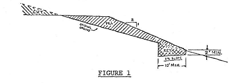
“Key” means a designed, compacted fill placed in a trench excavated in undisturbed earth material beneath the toe of a proposed fill slope to develop shearing resistance (see Figure 1).
“Land disturbance” means clearing, excavating, grading, or other manipulation of the natural terrain.
“One-hundred-year storm” means a storm with such intensity and duration that its magnitude would only be exceeded on the average once every one hundred years.
“Owner” means the person or persons shown in the county recorder’s office as owner of property.
“Permittee” means the owner, contractor, or any person undertaking land disturbance activities upon a site pursuant to a permit granted by the city.
“Riparian corridor” means those areas which fall into one of the following three categories:
1. An area extending fifty feet (measured horizontally) from each side of a perennial stream. Distance shall be measured from the one-hundred-year storm flowline.
2. An area extending thirty feet (measured horizontally) from each side of an intermittent stream. Distance shall be measured from the one-hundred-year storm flowline.
3. An area extending thirty feet from the one-hundred-year flood high water mark of a marsh or a natural body of standing water.
“Road gradient” means vertical rise or distance multiplied by one hundred and divided by horizontal run or distance.
“Runoff” means the movement of surface water over ground surface.
“Sediment” means eroded earth material that is carried by water, wind, gravity or ice and deposited into channels, lakes, rivers or other areas.
“Site” means a parcel of land or contiguous parcels where land disturbance including erosion control, clearing, grading, or construction are performed or proposed.
“Slope” means an inclined ground surface, the inclination of which is expressed as a ratio of horizontal distance to vertical distance.
“Soil” means naturally occurring mineral and organic earth materials on the immediate surface overlying bedrock or parent material.
“Stream” means any watercourse as designated by a solid line or dash and three dots symbol shown on the largest scale of United States Geological Survey map most recently published.
“Ten-year storm” means a storm with such intensity and duration that its magnitude would only be exceeded on the average once every ten years.
“Terrace” means a relatively level step constructed in the face of a graded slope surface for drainage and maintenance purposes.
“Topsoil” means eight to sixteen inches of loose, friable, organic, and fertile earth materials on top of a soil profile, usually the A-horizon.
“Waterbreak” means a ditch, dike, dip, or combination thereof, constructed to effectively divert water as an aid to erosion control. (Ord. 595 § 2, 1981)
15.32.030 Control of accelerated erosion required.
No person shall cause or allow the persistence of a condition on any site that could cause accelerated erosion. Accelerated erosion shall be controlled and/or prevented by the responsible person or the property owner by using measures outlined in subsequent sections as applicable. Additional measures may be necessary, and may be specifically required by the city engineer. (Ord. 595 § 3, 1981)
15.32.040 Abatement of hazardous conditions required.
Whenever the city engineer determines that an existing excavation or embankment or cut or fill has become a hazard to life or limb, or endangers property, or adversely affects the safety, use, or stability of a public way or drainage channel or causes significant impact on the natural resources of the area, the owner of the property upon which the excavation, cut, or fill is located, or other person or agent in control of the property, upon receipt of notice in writing from the city engineer shall, within the period specified therein, repair or eliminate such excavation or embankment so as to eliminate the hazard and be in conformance with the requirements of this chapter. Where feasible, erosion problems shall be controlled no later than the beginning of the next rainy season (approximately October 15th). (Ord. 595 § 4, 1981)
15.32.050 Permit – Exemptions.
Excavation, grading, filling, clearing, and/or erosion control work requires a permit from the city except for the following exemptions:
A. Subdivisions. When erosion control and grading plans comply with this chapter and have been approved at the time a subdivision map was approved;
B. Building Pads and Driveways. Grading, when done with a valid building permit;
C. Emergency Work. Work necessary to preserve life or property; provided, however, that when emergency work is performed under this section, the person performing it shall report the pertinent facts relating to the work to the city engineer within fifteen days after commencement of the work. Thereafter the person shall obtain a permit pursuant to SMC 15.32.060 through 15.32.110 and perform such work as may be determined by the city engineer to be reasonably necessary to correct any erosion or conditions with a potential to cause erosion as a result of the emergency work;
D. Excavations. An excavation which does not exceed seventy-five cubic yards and is less than two feet in depth, or which does not create a cut slope greater than five feet in height and steeper than two horizontal to one vertical;
E. Fill. A fill, except when in a riparian zone, containing earth materials only which is less than two feet in depth, is placed on natural terrain with a slope flatter than five horizontal to one vertical, does not exceed one hundred cubic yards on any one site, does not alter or obstruct a drainage course, and will not be used for structural support or roadways;
F. Basements and Footings. An excavation below finished grade for basements and footings of a building, retaining wall or other structure authorized by a valid building permit. This shall not exempt any fill except as provided under subsection E of this section, made with the material from such excavation, nor exempt any excavation having an unsupported height greater than five feet after the completion of such structures;
G. Cemeteries. Cemetery graves;
H. Refuse Disposal. Refuse disposal sites which are permitted and actually being controlled pursuant to other city regulations, and excavations for individual and community sewage disposal systems made pursuant to other city permits;
I. Wells. Excavations for wells;
J. Soil Investigations. Exploratory excavations under the direction of a soils engineer or engineering geologist where such excavation is to be returned to the original condition under the direction of such engineer or geologist within forty-five days after the start of work;
K. Agricultural Work. Use of land operated under a conservation plan by a resource conservation district. Routine plowing, harrowing, discing, listing, leveling, and similar operations necessary to prepare a field for a crop. Not exempted shall be initial grading to convert land from nonproductive to crop producing use;
L. Public Works. Work in connection with public improvement projects for which inspection is provided by the city or other public agency. (Ord. 595 § 5, 1981)
15.32.060 Permit – Required.
Except as exempted in SMC 15.32.050, a permit shall be obtained from the city by the owner(s) of the property, or agent when authorized in writing, for each site. Approval of a permit for a new development shall require the abatement of any existing human-induced or accelerated erosion problems on the property. (Ord. 595 § 6(1), 1981)
15.32.070 Permit – Application – Plans and specifications required.
Two sets of plans, plus supporting data, shall be required for each application when required by the city engineer. Plans shall be drawn to scale upon substantial material, minimum size eighteen inches by twenty-four inches, and shall be of sufficient clarity to indicate the nature and extent of the work proposed and show in detail that it will conform to the provisions of this chapter and all relevant laws and regulations. The first sheet of each set of plans shall include the location and assessor’s parcel number(s) of work, the name, telephone number, and address of the owner(s), and the name, telephone number, and address of person by whom they were prepared. The plans shall include the following information in writing, diagrams, and/or scale drawings:
A. Statements as to the specific intention or ultimate purpose for which the grading is being done;
B. General location and vicinity of the proposed site;
C. Property lines and accurate contours of the existing ground and details of terrain and area drainage without existing vegetation. Contour intervals shall be one foot when the natural ground slope is less than five percent; two feet when five to ten percent; and five feet when slope is more than ten percent. Contours shall overlap fifteen feet onto adjacent properties;
D. Limiting dimensions, elevations or finished contours to be achieved by the grading and proposed drainage channels and related construction, including proposed vegetation, landscaping, and comparison of runoff without project and with project. Finished grade contours will be shown as they relate to surrounding property contours;
E. Detailed plans and location of all temporary and permanent structure and nonstructure erosion and sediment control devices, and of all surface and subsurface drainage devices, walls, cribbing, dams, sediment basins, storage reservoirs, and other protective devices to be constructed with, or as a part of, the proposed work, together with a map showing the drainage area with the complete drainage network and the estimated runoff of the area served by any drains. The location, capacity and condition of any ravines and drainage courses in the pathway of off-site runoff or drainage shall be indicated;
F. The planned direction and disposition of all storm drainage flow (with approximate grade) from all buildings, yards, lots, driveways, parking areas, and streets;
G. Vegetative erosion control and revegetation measures for all surfaces exposed or expected to be exposed during grading activities as a part of overall erosion and sediment control plans;
H. Locations of buildings or structures on the property where the work is to be performed and the approximate location of buildings or structures on adjacent lands owned by other owners which is within fifteen feet of the property line, or which may be affected by the proposed operations;
I. A statement of the quantity of excavation and fill;
J. Specifications, when required, shall contain information covering construction and material requirements;
K. Estimated starting and completion dates;
L. Soil description, including soil types, depth, erodibility, and vegetative establishment and growing capabilities;
M. Extent and manner of tree cutting and/or vegetative clearing, including a disposal plan;
N. A provision for stock piling topsoil when necessary for erosion control or landscaping;
O. North arrow, written and graphic scales. (Ord. 595 § 6(2), 1981)
15.32.080 Permit – Application – Engineering requirements.
A civil engineer or other licensed professional authorized by state law shall prepare and sign the plans and specifications and be coordinator and liaison between other professionals, owners, contractors and the city engineer of:
A. Subdivisions of more than four lots;
B. Grading in excess of two thousand cubic yards;
C. Planned unit developments, major planned developments, and major use permits;
D. Other projects and/or developments likely to cause major land disturbances, as determined by the city engineer. (Ord. 595 § 6(3), 1981)
15.32.090 Permit – Application – Engineering reports required.
When required by the city engineer, each application for a permit shall be accompanied by two sets of supporting data consisting of a soil and/or civil engineering report and/or engineering geology report, and/or any other reports necessary.
A. The soil engineering report shall include data regarding feasibility of the site for the proposed uses; recommendations for grading, including site preparation and placement of fill; nature, distribution, erosion hazards and strength of existing surface and subsurface soils; foundation recommendations; finished slope stability; design of buttress fills; recommendations for seismic and erosion control; and surface and subsurface drainage;
B. The civil engineering report shall include hydrological calculations of runoff for ten-year and one-hundred-year storm frequencies; conclusions and recommendations for adequate erosion control and grading procedures; comparison of runoff without and with project; design criteria for corrective measures, including the existing and/or required safe storm drainage capacity outlet of channels both on site and off site; and opinions and recommendations covering adequacy of the site to be developed by the proposed grading.
C. The engineering geology report shall include an adequate description of the geology of the site, potential geologic hazard and conclusions and recommendations regarding the effects of geologic conditions on the proposed development, plus opinions and recommendations covering the adequacy and stability of the geologic subsurface for cuts and fill loads to be developed by the proposed grading.
D. Recommendations included in the reports when approved by the city engineer shall be incorporated in the plans and specifications. (Ord. 595 § 6(4), 1981)
15.32.100 Variances.
A request for variance from the provisions of this chapter, the permit conditions, or the plan specifications may be approved, conditionally approved, or denied by the city engineer. A request for a variance must state in writing the provision to be varied, the proposed substitute provision, when it would apply and its advantages. (Ord. 595 § 6(5), 1981)
15.32.110 Work time limits.
A. The permittee shall fully perform and complete all the work required to be done within the time limits specified. If no time limit is specified, the permittee shall complete the work within one hundred eighty working days after the date of the issuance of the permit. If work has not started within one hundred eighty days after the permit is issued, it expires. If work authorized is started and suspended or abandoned for one hundred eighty calendar days, the permit also expires unless stoppage has been authorized in advance by the city engineer.
B. If the permittee is unable to complete the work within the specified time, he shall, prior to the expiration of the permit, present in writing a request for an extension of time, setting forth the reasons for the requested extension. If, in the opinion of the city engineer, an extension is warranted, additional time may be granted for the completion of the work. (Ord. 595 § 6(6), 1981)
15.32.120 Fees.
Fees, if any, necessary to implement this chapter shall be as set forth in Tables 3E and 3F, page 34 of the 1979 Edition of the California Administrative Code. (Ord. 1044 § 2 (Att. D), 2017; Ord. 595 § 7, 1981)
15.32.130 Bonds.
The city engineer may require bonds in such form and amounts as may be deemed necessary to assure that the work, if not completed in accordance with the approved plans and specifications, will be done.
In lieu of a surety bond, the applicant may file a cash bond or instrument of credit with the city engineer in an amount equal to that which would be required in the surety bond. (Ord. 595 § 8, 1981)
15.32.140 Design standards – Cut and excavation.
A. General. Unless otherwise recommended in the soil engineering and/or engineering geology reports approved by the city engineer, cuts and excavations shall conform to the provisions of this section.
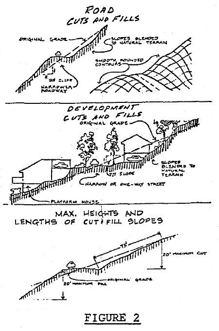
B. Slope. The slope of cut surface shall be no steeper than is safe for the intended use. Cut slopes shall be no steeper than two horizontal to one vertical, and shall not exceed twenty feet in vertical height or exceed seventy-five feet slope (horizontal) distance without a bench or terrace break. Due to individual site soils and geology, flatter and shorter slope lengths may be required, or steeper and longer slope lengths may be allowed upon review by the city engineer when he finds this consistent with the building and safety. Cut slopes shall be rounded off so as to blend in with natural terrain (see Figure 2).
C. Stockpiles. Stockpile material for trenches and pits will be put upslope of the excavation to be promptly backfilled and compacted into trenches and pits. Excavated material not needed at the site will be removed or disposed of at a location approved by the city engineer.
D. Vegetative Protection. All earth cuts shall be planted or otherwise protected from the storm runoff erosion within thirty days of the completion of final erosion control and grading work. Planting shall be irrigated to establish a root system before the rainy season, if necessary in the opinion of the city engineer. (Ord. 595 § 9, 1981)
15.32.150 Design standards – Fill.
A. General. Unless otherwise recommended in the soil engineering and/or engineering geology reports approved by the city engineer, fill shall conform to the provisions of this section.
B. Fill Location. Fill shall not be constructed on natural slopes steeper than 2:1 unless an engineer devises a method of placement which will ensure the fill will remain in place. The toe of the fill shall be no closer than twelve feet horizontally to the top of existing or planned cut slopes. The area beyond the toe of the fill shall be sloped for sheet overflow or a drain shall be provided (see Figure 3).
C. Fill Slopes. The slope of fill surfaces can be no steeper than is safe for the intended use. Fill slopes shall be no steeper than 2:1 and shall not exceed twenty feet vertical height or seventy-five feet slope (horizontal) distance without a terrace break. Due to individual soil properties, shorter and flatter slopes may be required or steeper and longer slopes may be allowed upon review by the city engineer if he finds the deviations consistent with stability and safety. Fill slopes shall be rounded off so as to blend with the natural terrain (see Figure 3).
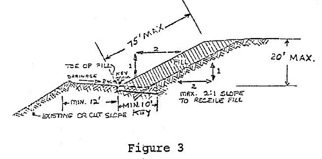
D. Ground Preparation. Natural ground surface over which fills are planned shall first be cleaned of all trash, vegetation, stumps, debris, noncomplying fill, top soil and other unsuitable materials and shall be scarified prior to the placement of the fill. Where slopes are 5:1 or steeper, a key, ten feet wide minimum, shall be dug into undisturbed, solid competent soil or bedrock beneath the toe of the proposed fill. The key must be cut and approved as a suitable foundation for fill before placing any fill (see Figures 1 and 3).
E. Materials Permitted. Only earth material free from tree stumps, detrimental amounts of organic matter, trash, garbage, sod, peat and/or similar materials shall be used. Rocks and/or broken concrete larger than six inches in greatest dimension shall not be used unless the method of placement is approved by the city engineer. Topsoil may be used in the top twelve-inch surface layer to aid in planting and landscaping.
F. Compaction of Fill. All fills shall be compacted to a minimum relative dry density of ninety-five percent as determined by ASTM D-1557-78 or CALTRANS test method under California 216. Field density verification must be submitted for any fill twelve inches or more in depth where such fill may support the foundation for a structure. A higher relative dry density and/or additional compaction tests may be required at any time by the city engineer.
G. Vegetative Protection. All earth fill shall be planted or otherwise protected from the effects of storm runoff within thirty days of the completion of final grading, and planting shall be irrigated to establish a root system, if necessary in the opinion of the city engineer. (Ord. 595 § 10, 1981)
15.32.160 Design standards – Cut and fill setbacks.
A. General. Unless otherwise recommended in the approved soil engineering and/or engineering geology reports and shown on the approved grading plan, setbacks shall conform to this section and be no less than as shown in Figure 4.
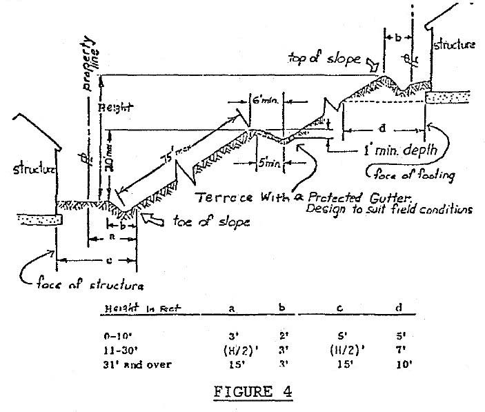
B. Minimum Setbacks. Tops and toes of cut and filled slopes shall be set back from property boundaries and structures as far as necessary for the safety of the adjacent properties and to prevent damage resulting from water runoff, by flooding, erosion of the slopes, or by sediment deposition (see Figure 4).
C. Stream and Riparian Setbacks. Tops and toes of cut and/or filled slopes shall be set back far enough to prevent encroachment upon streams, floodplains, channels, or bodies of standing water and to provide and maintain an undisturbed protective strip between the grading and the riparian corridor. This strip shall have sufficient filter capacity as determined by the city engineer to prevent degradation of water quality. If it is determined that the filter capacity of the protective strip is insufficient, additional erosion control may be required by increasing the width of the protective strip or with structural measures and/or by seeding, planting, mulching of bare soil areas.
D. Retaining Walls. Retaining walls, when keyed into stable foundations and capable of sustaining the design loads, may be used to reduce the required cut and fill setbacks when recommended by the civil or soil engineers, or geologist and approved by the city engineer. Other restrictions and/or minimums may be increased or related upon review by the city engineer if he finds the deviations consistent with safety and stability and to provide access for slope maintenance and drainageways. (Ord. 595 § 11, 1981)
15.32.170 Design standards – Drainage and terraces.
A. General. Drainage facilities and terraces shall conform to the provisions of this section unless otherwise indicated on the approved permit and plans. To the greatest extent possible, peak storm drainage runoff and sediment rates may not exceed predevelopment rates. A pro rata share of the cost of off-site erosion sediment, and flood control improvements and/or for maintenance to the principal drainageway, may be required by the city engineer to handle the increased peak runoff and/or sediment generated by the development if greater than predevelopment rates.
B. Runoff Calculations. Plans and specifications prepared for subdivisions, projects and/or developments, shall show, by table and/or calculations, the peak rates of storm runoff both before and after development. A combination of storage and controlled release of storm water runoff may be required.
C. Drainage Facilities.
1. Disturbance of natural drainageways shall be kept to a minimum and existing drainage courses shall not be obstructed or obliterated without mitigating measures installed that have been approved by the city engineer.
2. Whenever a grading operation obstructs or impairs the flow of runoff in an existing drainage course, a culvert, bridge or other suitable drainage facility designed and acceptable to the city engineer shall be installed to convey the flow past the point of impairment. No construction materials or construction byproducts shall be discarded in any drainageway or riparian zone.
3. Drainage facilities shall be culverts, pipe drains, paved, rock, or vegetative channels designed to safely carry existing and potential off-site runoff from a fully developed area upstream as well as local on-site surface and subsurface waters to the nearest adequate drainage course designated for such purposes by the city engineer. Properly designed energy dissipators are required at the point of discharge.
4. Culvert size and industry standard materials shall be used in accordance with city standard design criteria and as approved by the city engineer. Minimum diameter shall be twelve inches.
5. Cuts, fills, and retaining walls shall have subsurface drainage facilities as necessary for stability.
6. Berms, ditches, interceptor drains, or swales, may be constructed at the top of cut and fill slopes when necessary for protection against water runoff. Minimum size interceptor drains above cut slopes with a tributary drainage area greater than forty feet measured horizontally or an area larger than one-third acre shall be paved with three inches of reinforced concrete or gunite and shall be twelve inches deep with thirty-six-inch paved width and discharge into downdrain. Energy dissipators may be required by the city engineer.
7. At least a one percent grade will be required toward an improved storm drainage facility, either existing or planned, from all building sites, pads, yards, roof drains, driveways, etc.
8. Grading equipment shall not disturb or cross flowing streams unless absolutely necessary and only with prior approval from the city engineer.
D. Terraces.
1. Terraces at least six feet in width shall be established at not more than twenty-foot vertical intervals or seventy-five-foot slope horizontal intervals. Suitable access shall be provided to permit proper grading and maintenance of these terraces. Where only one terrace is required, it shall be at mid height (see Figure 4).
2. Swales or interceptor pipes or drains, ditches, on terraces and on the top of cut slopes, shall be designed to carry water and sediment to safe disposal structures and areas and shall have a minimum gradient of one percent and must be paved with concrete or gunite not less than three inches in thickness or other paved or vegetative approved nonerodible surface. They shall have a minimum depth of one foot and a minimum paved or protected area of five feet (see Figure 4). A revegetation and maintenance plan may be required by the city engineer. (Ord. 595 § 12, 1981)
15.32.180 Design standards – Erosion and sediment control.
A. General. Buildings and access envelopes shall be delineated on the development plans when necessary to keep disturbance out of particularly erodible areas. New lots shall not be created which will require access road and driveways to cross slopes exceeding fifty percent (2:1) for distances greater than fifty feet. Exposed soil shall be protected from erosion by temporary and/or permanent measures. Such protection may consist of mulching, plastic sheeting, and/or vegetation.
B. Slope. Structures on existing slopes exceeding thirty percent shall utilize pole, step or other such foundation that does not require major excavations or fillings (see Figure 3), unless otherwise approved by the city engineer.
C. Runoff Control. Where concentrated runoff will occur, it will be carried in pipe or culvert conduits or over a nonerodible surface (paved, rocked, or vegetated) with discharge points clearly shown on the development plans. All conduits must have proper energy dissipators at the point of discharge when necessary to prevent erosion.
D. Building Site Runoff. Runoff from buildings, roads, driveways and the total site area shall be controlled by berms, swales, ditches, structures, vegetative filter strips and/or catch basins to prevent the escape of sediment from the site.
E. Vegetative Removal. Development plans shall indicate the areas where vegetation is to be removed and replaced within the building and access envelopes. Vegetation removal shall be limited to that amount necessary and as indicated on the approved development plan. The method and time shall be such that the erosive effects are minimized.
F. Vegetative Disposal. Vegetation removed during clearing operations shall be disposed of by chipping, used as mulch, compost, and/or by burning. Burning shall comply with local air quality standards and no long branches or charred pieces shall be permitted to remain.
G. Topsoil. To promote regrowth of vegetation, the topsoil shall be stockpiled and reapplied upon completion of grading on slopes of less than 5:1 (twenty percent). Soil stockpiles and exposed soil shall be protected from erosion at all times.
H. Temporary Vegetation. Temporary vegetation sufficient to stabilize the soil as permanent vegetation cover is maturing shall be established on all disturbed areas as needed and as each stage of grade is completed.
I. Winter Operations. (October 15th to April 15th).
1. Land disturbance or development operations may be restricted or temporarily halted between October 15th and April 15th (the normal rainy season), and/or other times whenever the city engineer determines that the weather, soil, slope and general site conditions may cause serious accelerated erosion or sediment damage either on site or downstream. When work is allowed, native ground cover shall not be cleared, destroyed, burned or disturbed more than fifteen days prior to grading or construction work unless approved in advance by the city engineer.
2. When land development work is allowed during the normal, rainy winter season, adequate erosion and sediment control measures must be in place during any land disturbance, and temporary erosion control measures must be applied to all soils bared at the end of each day.
3. During winter, sufficient erosion control materials of straw, plastic, netting, etc., shall be kept on the site at all times to be installed immediately by the permittee upon advent of any rainfall or wind that may be expected to cause accelerated erosion.
4. All cut and fill slopes without established vegetation between October 15th and April 15th shall be mulched. The mulching shall be anchored by punching or tacking into the soil or by the use of netting. A minimum of one thousand pounds of straw, or equivalent, per each ten thousand square feet of slope surface will be required to be anchored. An additional amount may be required by the city engineer.
5. Within ten working days after seeding, fertilizing and/or mulching, the permittee will commence irrigation of the seeded areas or slopes and shall continue until the rains come and/or the ground cover is fully developed. Berms, diversion catch basins, etc., shall be installed prior to seeding and mulching.
6. All erosion control plantings and mulching shall be closely monitored throughout the winter and runoff problems corrected promptly. All erosion and/or slippage of banks shall be repaired by the permittee at his expense.
J. Dust. Dust from grading operations must be controlled. The permittee may be required to keep adequate equipment on the grading site to prevent dust problems.
K. Erosion Control Coordination with Project Installation.
1. All vegetative and/or structural measures required to safely discharge any accelerated runoff generated by the project shall be installed during the first or initial construction phase of the project.
2. Land shall be developed in increments of workable size which can be completed in a single construction season. Erosion and sediment control measures shall be coordinated with a sequence of grading, development, and construction operations and all necessary erosion control measures shall be put in effect prior to the commencement of the next work increment and/or winter rainy season.
3. Prior to completion and final acceptance of the project, all erosion control measures must be in place and all exposed bare soil shall be mulched, fertilized and otherwise prepared so that it is planted to a permanent vegetative cover. Native or naturalized vegetation should be used. The city engineer may require watering of planted areas to initiate and assure growth.
L. Livestock. Where necessary to assure that water quality is not affected by the keeping of livestock, vegetative buffer and/or filter strips shall be established on all downhill sides of areas where livestock are kept. The width of the buffer strip shall be determined by the city engineer. Also, additional erosion control measures, such as diversion, dissipators and sediment basins may be required to control runoff from these areas where livestock have destroyed and torn up protective vegetation.
M. Maintenance. All on-site erosion control facilities shall be properly maintained by the owners for the life of the project so that they do not become nuisances with stagnant water, heavy algae growth, insect breeding, odors, discarded debris, and/or safety hazards. Vegetative maintenance required may include mowing, fertilization, irrigation and/or reseeding. (Ord. 595 § 13, 1981)
15.32.190 Inspections and compliance required.
Excavation, grading, filling, clearing and erosion control work requiring a permit shall be subject to inspection by the city engineer. In lieu of inspection by city staff employees, the city engineer may require supervision, regular inspection, and special testing be performed and certified by the licensed professional who prepared the approved plan, or the city engineer may require supervision, inspection, and testing be done by an independent approved testing agency to ensure compliance with this chapter and the permittee’s permit conditions. (Ord. 595 § 14(1), 1981)
15.32.200 Required inspections.
The following inspections shall be required, but not limited to:
A. Presite inspection to determine the suitability of the proposed project and the existing and potential erosion and sediment hazards;
B. Periodic ongoing inspection during project progress, including compaction and special testing as may be required by the approved plan;
C. Final inspection determining compliance with terms and conditions of this chapter and permit. (Ord. 595 § 14(2), 1981)
15.32.210 Notification of city engineer by permittee.
The permittee shall notify the city engineer two working days prior to the beginning of the operation authorized by the permit, and one complete working day prior to any inspection or testing requested by the permittee. (Ord. 595 § 14(3), 1981)
15.32.220 Right of entry of city.
Filing of an application for a permit under this chapter constitutes a grant of permission for the city to enter the permit area for the purpose of administering this chapter from the date of the application to the termination of the erosion control maintenance period. If necessary, the city engineer shall be supplied with a key or lock combination, or permitted to install a city lock. (Ord. 595 § 14(4), 1981)
15.32.230 Conflict with other codes.
All previous codes are superseded by this chapter and repealed insofar as they conflict with this chapter. The city engineer shall have the authority to make interpretations of the sections of this chapter, and shall have the authority to determine which of the conflicting requirements shall govern. (Ord. 595 § 15, 1981)