


Chapter 17.20
SPECIFIC PLANS
Sections:
17.20.030 West Broadway Urban Village Specific Plan
17.20.040 The Projects at Main Gate Specific Plan
17.20.050 Campus Town Specific Plan
17.20.010 Purpose
The purpose of this chapter is to incorporate by reference adopted specific plans within the City of Seaside. Under California law, cities may adopt specific plans to develop policies, programs, regulations and guidelines to implement the jurisdiction’s adopted general plan. A specific plan effectively establishes a link between implementing policies of the General Plan and the individual development proposals in a defined area and may augment or replace development standards and regulations in place for the jurisdiction at large.
17.20.020 Applicability
The provisions of adopted specific plans apply to proposed land uses and development projects within the boundaries of each specific plan area, in addition to other applicable requirements of this Zoning Ordinance not covered by an adopted specific plan. If there is a discrepancy between an adopted specific plan and the Zoning Ordinance, the specific plan shall take precedence.
17.20.030 West Broadway Urban Village Specific Plan
A. Purpose and intent. The West Broadway Urban Village Specific Plan was adopted by the City on January 21, 2010, to facilitate a pedestrian-friendly Urban Village concept that offers a mix of market-rate and affordable for-sale and rental residences with ground-floor retail and commercial uses. Over time, the West Broadway Urban Village Specific Plan Area will become the City’s new downtown, strengthening the Seaside community by developing a strong urban core.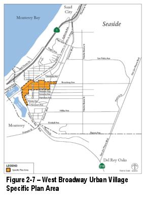
B. Applicability. All land use policies, development standards and design guidelines, and infrastructure improvements applicable to proposed land uses and development projects within the West Broadway Urban Village Specific Plan Area may be found in the adopted West Broadway Urban Village Specific Plan, available at Seaside City Hall, on the City’s website, or by contacting Planning Division staff directly. Cannabis medical and adult usage dispensaries shall be permitted land uses in this Specific Plan Area subject to obtaining a Conditional Use Permit in accordance with Chapter 17.60.
C. Specific Plan Area. The West Broadway Urban Village Specific Plan Area is located in the southwest portion of the City, immediately south of the Seaside Auto Mall. Figure 2-7 shows the boundaries of the Specific Plan Area, encompassing approximately 40 acres. The Plan Area includes Broadway Avenue between Fremont Boulevard and Del Monte Boulevard, and portions of Del Monte Boulevard, Palm Avenue, and Canyon Del Rey Boulevard. The Plan Area is approximately bounded by Olympic Avenue, Elm Avenue, Imperial Street, Canyon Del Rey Boulevard, and Harcourt Avenue. (Ord. 1046 § 1(B), 2018)
17.20.040 The Projects at Main Gate Specific Plan
A. Purpose and intent. The Projects at Main Gate Specific Plan was adopted by the City on July 15, 2010, to reuse a key portion of the former Fort Ord for regional commercial use, consistent with the General Plan and Base Reuse Plan. As adopted, the specific plan intends to provide a destination hotel, spa and conference facility to expand tourism and hospitality services in Seaside. Design objectives include an open-air retail environment with distinct districts, connections to state park land, pedestrian-scale architecture, and incorporation of energy-wise technology.
B. Applicability. All land use policies, development standards and design guidelines, and infrastructure improvements applicable to proposed land uses and development project within the Projects at Main Gate Specific Plan Area may be found in the adopted Projects at Main Gate Specific Plan, available at the City of Seaside City Hall, on the City’s website, or by contacting Planning Division staff directly.
C. Specific Plan Area. The Projects at Main Gate Specific Plan Area is located at the north “gateway” to the City on approximately 56 acres at the northwest corner of Lightfighter Drive and 2nd Avenue. Figure 2-8 shows the boundaries of the Specific Plan Area. The area is surrounded by Caltrans right-of-way, Highway 1 and state park land along the Pacific Ocean to the west, vacant land, deteriorating military barracks and Monterey County offices to the north; 2nd Avenue and recreational facilities of CSUMB to the east; and Lightfighter Drive and lands within the City of Seaside planned for mixed uses to the south.
17.20.050 Campus Town Specific Plan
A. Purpose and intent. The Campus Town Specific Plan was adopted to reuse a key portion of the former Fort Ord for a mix of residential and commercial uses, consistent with the General Plan and Base Reuse Plan. As adopted, the specific plan is intended to provide for a variety of building types and uses, including entertainment, retail, housing, visitor lodging, and employment space with sufficient resident population in proximity to proposed commercial uses to support a viable mixed use urban village.
B. Applicability. All land use policies, development standards, guidelines, infrastructure improvements and related provisions contained in the Campus Town Specific Plan are applicable to development within the Campus Town Specific Plan Area. The adopted Campus Town Specific Plan is available at Seaside City Hall, on the City’s website, or by contacting Planning Division staff directly.
C. Specific Plan Area. The Campus Town Specific Plan Area is located in the northern portion of the City, immediately south of California State University Monterey Bay (CSUMB). Figure 2-9 shows the boundaries of the Specific Plan Area, encompassing approximately 122 acres. The Campus Town Plan Area is generally bounded by 1st Avenue to the west and 7th Avenue to the east, by Lightfighter Drive and Colonel Durham Street to the north, and by Gigling Road to the south.
Figure 2-9 – Campus Town Specific Plan Area
(Ord. 1081 § 1 (Exh. A § 2)), 2020)