


Article 2
Zoning Districts, Allowable Land Uses, and Zone-Specific Standards
Division 36.200 Zoning Map
36.200.010 Purpose of Division
36.200.020 Zoning Map and Zoning Districts
Division 36.210 Development and Land Use Approval Requirements
36.210.020 General Requirements for Development and New Land Uses
36.210.030 Allowable Land Uses and Permit Requirements
36.210.040 Exemptions from Zoning Approval Requirements
Division 36.220 Residential Zoning Districts
36.220.010 Purpose of Division
36.220.020 Purposes of Residential Zoning Districts
36.220.030 Residential Zoning District Land Uses and Permit Requirements
36.220.040 Residential Zoning District General Development Standards
36.220.050 Development of Small Non-Conforming Residential Parcels
Division 36.230 Commercial Zoning Districts
36.230.010 Purpose of Division
36.230.020 Purposes of Commercial Zoning Districts
36.230.030 Commercial District Land Uses and Permit Requirements
36.230.040 Commercial District General Development Standards
36.230.050 Mixed Use Overlay Development Standards
Division 36.240 Special Purpose Zoning Districts
36.240.010 Purpose of Division
36.240.020 Purposes of Special Purpose Zoning Districts
36.240.030 Special Purpose District Land Uses and Permit Requirements
36.240.040 Special Purpose District General Development Standards
Division 36.250 Overlay Zoning Districts
36.250.010 Purpose of Division
36.250.020 Applicability of Overlay Zoning Districts
36.250.030 Altos de Monterey (AM) Overlay District
36.250.040 Mixed Use (MU) Overlay District
36.250.050 Housing Opportunity (HO) Overlay District
36.250.060 Camino del Cielo (CDC) Overlay District xx
Division 36.200. Zoning Map
Sections:
36.200.010 Purpose of Division.
36.200.020 Zoning Map and Zoning Districts.
36.200.010 Purpose of Division.
This Division establishes the zoning districts applied to property within the City, and adopts the City’s Zoning Map.
(Ord. No. 2108 § 1.)
36.200.020 Zoning Map and Zoning Districts.
The official City of South Pasadena Zoning Map has been adopted by the Council and is on file in the Department.
A. Zoning districts established. The City of South Pasadena shall be divided into zoning districts which implement the General Plan. The zoning districts shown in Table 2-1 are hereby established, and shall be shown on the Zoning Map.
B. Interpretation of zoning district boundaries. If there is uncertainty about the location of any zoning district boundary shown on the Zoning Map, the precise location of the boundary shall be determined by the Director.
1. Where district boundaries approximately follow lot, alley, or street lines, the lot lines and/or street and alley centerlines shall be construed as the district boundaries as appropriate;
2. Where a public street or alley is officially vacated or abandoned, the property that was formerly in the street or alley will be included within the zoning district of the adjoining property on either side of the centerline of the vacated or abandoned street or alley.
The Director may refer any question of interpretation of the Zoning Map to the Commission for a determination, at a public hearing.
C. Annexations. Areas annexed to the City shall be zoned according to the pre-annexation zoning classification until City zoning is applied to the site in compliance with Division 36.620 (Amendments).
|
TABLE 2-1. ZONING DISTRICTS |
||
|---|---|---|
|
Zoning District Symbol |
Zoning District Name |
General Plan Land Use Classification Implemented by Zoning District |
|
Residential Districts |
||
|
RE |
Residential Estate |
Very Low Intensity Neighborhood |
|
RS |
Residential Single Family |
Low Intensity Neighborhood |
|
RM |
Residential Medium Density |
Medium Intensity Neighborhood |
|
RH |
Residential High Density |
High Intensity Neighborhood |
|
Commercial Districts |
||
|
CG |
Commercial General |
Mixed Use Core; Fair Oaks Corridor |
|
CO |
Commercial Office |
Mixed Use Core |
|
BP |
Business Park |
Mixed Use Core |
|
Special Purpose Districts |
||
|
CF |
Community Facilities |
Civic |
|
OS |
Open Space |
Parks and Open Spaces; Preserves |
|
DTSP |
Downtown Specific Plan |
Mixed Use Core; Fair Oaks Corridor |
|
HFSP |
Holy Family Specific Plan |
Civic |
|
Overlay Districts |
||
|
AM |
Altos de Monterey |
Very Low Density Neighborhood |
|
CDC |
Camino del Cielo Overlay |
Very Low Density Neighborhood |
|
MU |
Mixed Use Overlay |
Mixed Use Core |
(Ord. No. 2108 § 1; Ord. No. 2379 § 5 (Exh. A), 2023; Ord. No. 2386 § 5 (Exh. A), 2024; Ord. No. 2399 § 4, 2025.)
Division 36.210. Development and Land Use Approval Requirements
Sections:
36.210.020 General Requirements for Development and New Land Uses.
36.210.030 Allowable Land Uses and Permit Requirements.
36.210.040 Exemptions from Zoning Approval Requirements.
36.210.010 Purpose.
This Division describes the City’s requirements for the approval of proposed development and new land uses. The permit requirements established by this Zoning Code for specific land uses are in Divisions 36.220 through 36.250.
(Ord. No. 2108 § 1.)
36.210.020 General Requirements for Development and New Land Uses.
All land uses and structures shall be established, constructed, reconstructed, altered, relocated, or replaced in compliance with the following requirements.
A. Allowable use. The land use shall be allowed by this Zoning Code in the zoning district applied to the site. The basis for determining whether a use is allowable is described in Section 36.210.030 (Allowable Land Uses and Permit Requirements).
B. Permit and approval requirements. Any zoning approval or other approval required by Section 36.210.030 shall be obtained before commencing construction of the proposed use, or otherwise established or put into operation, unless the proposed use is listed in Section 36.210.040 (Exemptions from Zoning Approval Requirements).
C. Development standards, conditions of approval. Land uses and structures shall comply with the development standards of this Article, the provisions of Article 3 (Site Planning and General Development Standards), and any applicable conditions imposed by a previously granted zoning approval.
D. Design guidelines. Land uses and structures shall comply with the design guidelines to the extent required by the Review Authority and/or specific provisions of the design guidelines.
E. Legal parcel. The proposed site shall be a parcel that was legally created in compliance with the Subdivision Map Act, and Article 5, Subdivisions, or earlier City subdivision regulations in effect at the time the parcel was created.
(Ord. No. 2108 § 1; Ord. No. 2183 § 1, 2009.)
36.210.030 Allowable Land Uses and Permit Requirements.
A. Allowable land uses. The uses of land allowed by this Zoning Code in each zoning district are listed in Tables 2-2, 2-4, and 2-6, together with the type of zoning approval required for each use.
1. Establishment of an allowable use.
a. Any parcel or structure may be approved with one or more of the land uses identified by the tables as being allowable within the applicable zoning district, subject to all applicable requirements of this Zoning Code, and the zoning approval requirements of Subsection B. for each individual use.
b. Where a single development proposal includes multiple uses, the overall project shall be subject to the highest permit level required by Subsection B. for any of the individual uses proposed. For example, a new building proposed in the CG zoning district with retail on the ground floor, offices on the second floor, and apartments on the third floor would require Conditional Use Permit (CUP) approval because Table 2-4 allows “mixed-use residential” (residential uses as part of an otherwise non-residential project), subject to a CUP in the CG district even though “general retail” and “offices, professional and administrative” are permitted uses, requiring only a Planning Clearance.
2. Uses not listed. Land uses that are not listed in tables or are not shown in a particular zoning district are not allowed, except as otherwise provided by Section 36.210.040 (Exemptions from Zoning Approval Requirements), and as follows.
a. Similar uses may be allowed. Using the interpretation procedures in Division 36.110, the Director may determine that a proposed use not listed in Tables 2-2, 2-4, and 2-6 is allowable if all of the following findings are made:
(1) The characteristics of, and activities associated with the proposed use are equivalent to one or more of the listed uses, and will not involve a higher level of activity or population density than the uses allowed in the district;
(2) The proposed use will be consistent with the purposes of the applicable zoning district; and
(3) The proposed use will be consistent with the General Plan and any applicable Specific Plan.
b. Applicable standards and permit requirements. When the Director determines that a proposed, but unlisted, use is equivalent to a listed use, the proposed use will be treated in the same manner as the listed use in determining where it is allowed, what permits are required, and what other standards and requirements of this Zoning Code apply.
c. Commission determination. The Director may forward questions about equivalent uses directly to the Commission for a determination at a public meeting.
B. Permit requirements. Tables 2-2, 2-4, and 2-6 provide for land uses that are:
1. Permitted subject to compliance with all applicable provisions of this Zoning Code, subject to first obtaining a Planning Clearance (Section 36.410.020), and any Building Permit or other permit required by the Municipal Code. These are shown as “P” uses in the tables;
2. Allowed subject to the approval of an Administrative Use Permit (Section 36.410.060) and shown as “AUP” uses in the tables; and
3. Allowed subject to the approval of a Conditional Use Permit (Section 36.410.060), and shown as “CUP” uses in the tables.
4. A project may require design review by the Director, the Planning Commission Chair, the Planning Commission (for a Hillside Permit) and/or the Cultural Heritage Commission (if required to obtain a Certificate of Appropriateness), in addition to the permit requirements above. See Section 36.410.040 (Design Review).
(Ord. No. 2108 § 1; Ord. No. 2394 § 4 (Exh. A), 2025.)
36.210.040 Exemptions from Zoning Approval Requirements.
The zoning approval requirements of this Zoning Code, other than those of the Cultural Heritage Commission, do not apply to the land uses, structures, and activities identified by this section. These are allowed in all zoning districts subject to compliance with this section.
A. General requirements for exemption. The land uses, structures, and activities identified by Subsection B. below are exempt from the zoning approval requirements of this Zoning Code only when:
1. The use, activity or structure is established and operated in compliance with the setback requirements, height limits, and all other applicable standards of this Article and Article 3 (Site Planning and General Development Standards);
2. The use, activity or structure is not subject to design review (Section 36.410.040), or by the Planning Commission for a Hillside Development Permit (Section 36.410.065); and
B. Exempt activities and uses. The following are exempt from zoning approval requirements when in compliance with Subsection A. above, provided that any permit or approval required by regulations other than this Zoning Code is obtained (for example, a Building Permit).
1. Decks, paths and driveways. Decks, platforms, on-site paths, and driveways that are not required to have a Building Permit or Grading Permit by the Municipal Code.
2. Fences and walls. See Section 36.300.050 (Walls, Fences and Hedges).
3. Interior remodeling. Interior alterations that do not increase the number of rooms or the gross floor area within the structure, or change the permitted use of the structure.
4. Portable spas, hot tubs, and fish ponds. Portable spas, hot tubs, fish ponds, and similar structures and equipment, that do not: exceed 120 square feet in total area including related equipment; contain more than 2,000 gallons of water; or exceed three feet in depth. These facilities shall comply with the setback requirements established by this Article for the applicable zoning district, or 36.350.170 (Residential Uses—Accessory Residential Structures), where applicable.
5. Repairs and maintenance. Ordinary repairs and maintenance, if:
a. The work does not change the approved land use of the site or structure, or add to, enlarge or expand the land use and/or structure; and
b. Any exterior repairs employ the same materials and design as the feature being repaired or replaced.
6. Small, portable residential accessory structures. Within residential zoning districts, a single portable structure, up to 120 square feet, per lot or dwelling unit, including pre-manufactured storage sheds and other small structures that are exempt from Building Permit requirements in compliance with the Municipal Code and the Uniform Building Code.
7. Solar collectors. The addition of solar collection systems to the roofs or sides of existing structures, provided that the collectors comply with applicable height limit requirements.
8. Utilities. The erection, construction, alteration, or maintenance by a public utility or public agency of underground or overhead utilities intended to service existing or nearby approved developments. These include: water, gas, electric, or telecommunications (telephone, cable TV, etc.) supply or disposal systems; including wires, mains, drains, sewers, pipes, conduits, cables, fire-alarm boxes, police call boxes, traffic signals, hydrants, etc., but not including new transmission lines and structures. Satellite and wireless communications antennas are subject to Section 36.350.210 (Telecommunications Facilities).
(Ord. No. 2108 § 1; Ord. No. 2183 § 2, 2009; Ord. No. 2394 § 4 (Exh. A), 2025.)
Division 36.220. Residential Zoning Districts
Sections:
36.220.010 Purpose of Division.
36.220.020 Purposes of Residential Zoning Districts.
36.220.030 Residential Zoning District Land Uses and Permit Requirements.
36.220.040 Residential Zoning District General Development Standards.
36.220.050 Development of Small Nonconforming Residential Parcels.
36.220.010 Purpose of Division.
This division lists the uses of land that may be allowed within the residential zoning districts established by SPMC 36.200.020 (Zoning Map and Zoning Districts), determines the type of zoning approval/approval required for each use, and provides basic standards for site layout and building size.
(Ord. No. 2108 § 1; Ord. No. 2379 § 5 (Exh. A), 2023.)
36.220.020 Purposes of Residential Zoning Districts.
Different residential zoning districts are intended to provide for a variety of housing opportunities through new construction, and the maintenance of existing homes and neighborhoods. The purposes of the individual residential zoning districts and the manner in which they are applied are as follows:
A. RE (Residential Estate) district. The RE zoning district applies to areas appropriate for detached, single-family residential homes on large estate parcels. The allowable residential density is a maximum of three dwelling units per acre. The RE zoning district is consistent with the Very Low Density Neighborhood land use designation of the General Plan.
B. RS (Residential Single-Family) district. The RS zoning district is intended for areas appropriate for the development of detached, single-family homes. The allowable residential density is a maximum of five dwelling units per acre. The RS zoning district is consistent with the Low Density Neighborhood land use designation of the General Plan.
C. RM (Residential Medium Density) district. The RM zoning district applies to areas appropriate for a variety of housing types. Typical residential land uses include single-family bungalow courts, courtyard housing, townhomes, duplexes, triplexes, multiplexes, and other attached dwellings on smaller lots. The allowable residential density ranges from 5.1 to 30 dwelling units per acre, except that any property in the RM district that is also included on the Housing Element Table VI-52 or VI-53 shall require a minimum density of 20 dwelling units per acre. Up to 70 dwelling units per acre are allowed for properties located within the Housing Opportunity (HO) Overlay District. The RM zoning district is consistent with the Medium Density Neighborhood land use designation of the General Plan.
D. RH (Residential High Density) district. The RH zoning district is intended for areas appropriate for high density attached dwelling units, including courtyard housing, townhouses, condominiums, and apartments. The allowable residential density ranges from 30.1 to 45 dwelling units per acre. Up to 70 dwelling units per acre are allowed for properties located within the Housing Opportunity (HO) Overlay District. The RH zoning district is consistent with the High Density Neighborhood land use designation of the General Plan.
(Ord. No. 2108 § 1; Ord. No. 2379 § 5 (Exh. A), 2023; Ord. No. 2386 § 5 (Exh. A), 2024; Ord. No. 2387 § 5 (Exh. A), 2024; Ord. No. 2388 § 6, 2024; Ord. No. 2403 § 4 (Exh. A), 2025.)
36.220.030 Residential Zoning District Land Uses and Permit Requirements.
A. General requirements. Table 2-2 identifies the uses of land allowed by this Zoning Code in each residential zoning district, and the zonings approval required to establish each use, in compliance with SPMC 36.210.030 (Allowable Land Uses and Permit Requirements).
Note: where the last column in the tables (“Specific Use Regulations”) includes a section number, the regulations in the referenced section apply to the use; however, provisions in other sections of this Zoning Code may also apply.
B. Altos de Monterey (AM) overlay district. Allowable land uses and permit requirements for parcels within the AM overlay district are established by SPMC 36.250.030.
|
TABLE 2-2. ALLOWED USES AND PERMIT REQUIREMENTS FOR RESIDENTIAL ZONING DISTRICTS |
P |
||||
|---|---|---|---|---|---|
|
CUP |
Conditional Use Permit required |
||||
|
AUP |
Administrative Use Permit required |
||||
|
— |
Use not allowed |
||||
|
PERMIT REQUIRED BY DISTRICT |
Specific Use Regulations |
||||
|
LAND USE (1) |
RE |
RS |
RM |
RH |
|
|
RECREATION, EDUCATION, PUBLIC ASSEMBLY & COMMUNITY FACILITY USES |
|||||
|
Clubs, lodges and fraternal organizations |
— |
— |
— |
CUP |
|
|
— |
— |
— |
CUP |
|
|
|
AUP |
AUP |
AUP |
AUP |
|
|
|
CUP |
CUP |
CUP |
CUP |
36.350.230 |
|
|
RESIDENTIAL USES |
|||||
|
Accessory residential uses and structures |
P(2) |
P(2) |
P(2) |
P(2) |
36.350.170 |
|
P |
P |
P |
P |
36.410.030 |
|
|
Multifamily dwellings |
— |
— |
P |
P |
36.350.180, 190 |
|
Organizational house (sorority, convent, etc.) |
— |
— |
CUP |
CUP |
|
|
Residential care facility, 6 persons or less |
P |
P |
P |
P |
|
|
Residential care facility, 7 persons or more |
— |
— |
CUP |
CUP |
36.350.050 |
|
— |
— |
CUP |
CUP |
36.350.050 |
|
|
P |
P |
P |
P |
36.350.200 |
|
|
P |
P |
P (but only if established in a legally existing single-family residential structure) |
P (but only if established in a legally existing single-family residential structure) |
36.350.265 |
|
|
Existing single-family dwelling |
P |
P |
P |
P |
|
|
New single-family dwelling |
P |
P |
— |
— |
|
|
Transitional and supportive housing |
P |
P |
P (multifamily types located in the RM district are subject to specific use regulations 36.350.180,190) |
P (multifamily types located in the RH district are subject to specific use regulations 36.350.180,190) |
|
|
SERVICE USES |
|||||
|
Bed & breakfast inn (B&B) |
CUP |
CUP |
CUP |
CUP |
36.350.070 |
|
Child day care center |
— |
— |
CUP |
CUP |
36.350.080 |
|
Child day care—Small family day care home |
P |
P |
P |
P |
36.350.080 |
|
Child day care—Large family day care home |
P |
P |
P |
P |
36.350.080 |
|
— |
— |
— |
CUP |
|
|
|
— |
— |
— |
CUP |
|
|
|
Notes: |
|||||
(Ord. No. 2108 § 1; Ord. No. 2197 § 2, 2009; Ord. No. 2246 § 3, 2013; Ord. No. 2251 § 5, 2013; Ord. No. 2253 § 3, 2013; Ord. No. 2372 § 2, 2023; Ord. No. 2379 § 5 (Exh. A), 2023; Ord. No. 2381 § 4, 2023; Ord. No. 2388 § 7, 2024.)
36.220.040 Residential Zoning District General Development Standards.
A. General requirements. Subdivisions, new land uses and structures, and alterations to existing land uses and structures, shall be designed, constructed, and/or established in compliance with the requirements in Table 2-3, in addition to the applicable development standards (e.g., landscaping, parking and loading, etc.) in Article 3 (Site Planning and General Development Standards).
B. Altos de Monterey (AM) overlay district. Development standards for parcels within the AM overlay district are established by SPMC 36.250.030.
C. Design guidelines and standards. Land uses and structures proposed within the residential zoning districts shall comply with the City’s Design Guidelines to the extent required by the review authority and/or specific provisions of the Design Guidelines, objective design standards, and to the extent permitted by State law. Qualifying residential projects shall comply with the ministerial approval process established by SPMC 36.410.040(D)(4).
|
TABLE 2-3. RESIDENTIAL DISTRICT GENERAL DEVELOPMENT STANDARDS |
||||
|---|---|---|---|---|
|
|
Requirement by Zoning District (1) |
|||
|
Development Feature |
RE |
RS |
RM |
RH |
|
Minimum lot size |
Minimum area and width for parcels proposed in new subdivisions. |
|||
|
Area |
12,500 sf |
10,000 sf |
10,000 sf |
10,000 sf |
|
Width |
75 ft; 85 ft for a corner lot |
50 ft; 60 ft for a corner lot |
60 ft; 80 ft for a corner lot |
70 ft |
|
Residential density |
Maximum number of dwelling units allowed in a project. The actual number of units allowed will be determined by the City through subdivision or land use permit approval, as applicable. |
|||
|
Allowable density |
Maximum of 3 du/acre |
Maximum of 5 du/acre |
5.1 to 30 du/acre (2) |
30.1 to 45 du/acre (3) |
|
Minimum and, where noted, maximum setbacks required. See SPMC 36.300.030 for setback measurement, allowed projections into setbacks, and specific exceptions to setbacks. |
||||
|
Front |
25% of lot depth, with a minimum of 25 ft, and a maximum requirement of 35 ft |
10 ft |
7.5 ft |
|
|
Front exception |
If 60 percent or more of the lots on the same block face have structures with front setbacks different from the above, the required front setback shall be the average of the existing front setbacks, provided that no more than 45 feet shall be required in the RE district, and 35 ft shall be required elsewhere. |
|
||
|
Sides, each |
10% of lot width |
10% of lot width, 4 ft minimum |
4 ft An additional minimum 1 ft setback from the property line shall be provided for each story above the second story. (i.e., 3-story building = 5 ft, 4-story building = 6 ft, etc.) |
4 ft; An additional 1 ft minimum setback from the property line shall be provided for each story above the second story. (i.e., 3-story building = 5 ft, 4-story building = 6 ft, etc.) |
|
Side, street side |
20% of lot width, to a maximum requirement of 15 ft |
10 ft minimum |
||
|
Rear |
25 ft |
15 ft minimum; or 5 ft minimum abutting an alley |
15 ft minimum; or 5 ft minimum abutting an alley |
|
|
An attached garage shall be set back a minimum of 10 ft from the front of the main structure |
N/A |
|||
|
As required for primary structures, except that: • A structure of 120 sf or less may be placed within a required side or rear setback, but not a front setback or in front of the frontmost dwelling unit on the lot; • A detached garage or carport or other accessory residential structure shall be located at least 5 ft from a side and/or rear property line, except if the required side yard setback for the dwelling/s is less than 5 ft, in which case the lesser side yard setback may be used for a detached garage or carport only. Such structures cannot be located in the front setback or in front of the frontmost dwelling unit on the lot; • Accessory structures shall be located at or beyond the required street-facing side yard setback for the dwelling/s, except if the Director determines that a lesser setback can be approved using the Administrative Use Permit process detailed in SPMC 36.350.170(C)(3)(e); |
See SPMC 36.350.170 (Residential Uses—Accessory Residential Structures) |
|||
|
|
• Private residential recreational facilities shall be located at least 5 ft from a side and/or rear property line and cannot be located in the front setback, or in front of the frontmost dwelling unit on the lot or in the street-facing side setback of a corner lot. See also SPMC 36.350.170 (Residential Uses—Accessory Residential Structures). |
|
||
|
Building separation |
10 ft between structures on the same site. |
Minimum distances shall comply with Fire Code requirements but in no case shall be less than 10 ft. |
||
|
Maximum percentage of total lot area that may be covered by structures. |
||||
|
40% |
N/A |
|||
|
Floor area ratio requirement |
0.35 |
N/A |
N/A |
|
|
Height limit |
Maximum allowable height of structures in other than hillside areas (see SPMC 36.340 (Hillside Protection) for height limits in hillside areas). See SPMC 36.300.040 (Height Limits and Exceptions) for height measurement requirements. See also SPMC 36.350.170 (Residential Uses—Accessory Residential Structures). |
|||
|
Maximum height |
35 ft |
45 ft For properties located in the HO Overlay District, the maximum height is 55 feet (see SPCMC 36.300.040(A). |
||
|
Multiple story exception |
No portion of a structure shall encroach through a 45 degree angle projected perpendicularly from the front property line toward the rear property line. See Figure 2-1 in this division. Building height in addition to the above limits may be authorized by design review (SPMC 36.410.040) to accommodate dormer windows and/or uninhabitable roof structures where appropriate to the architectural style of the dwelling. |
N/A |
||
|
Open Space (4) |
||||
|
Minimum total combined usable open space per residential unit (common and private combined) |
N/A |
200 sf per unit, minimum |
||
|
Common open space required |
N/A |
50% minimum of the total required open space; 1,000 sf minimum
Up to 25% of the required common open space may be indoor common open space such as fitness rooms, resident lounges and similar or typical facilities. Mail rooms and leasing offices and associated areas do not count toward the required open space. |
||
|
Dimensions of private open space |
N/A |
If individual balconies, ground floor patios, porches, or similar private open space are provided to meet the area requirements, such areas shall have minimum dimensions of 8 ft width and 6 ft depth. |
||
|
Dimensions of common open space |
N/A |
Common open space areas shall have a minimum dimension of 20 feet on any side. |
||
|
Dimensions of outdoor common open space and landscaping requirement |
|
Outdoor common open space shall have a minimum dimension of 20 feet in two directions. In addition, a minimum 20% of outdoor common open space shall be landscaped that may count toward the minimum site landscaping requirement. |
||
|
As required by SPMC 36.330 (Landscaping Standards) |
||||
|
Parking |
As required by SPMC 36.310 (Parking and Loading), unless such development qualifies for an exception to providing parking under provisions of State law |
|||
|
As required by SPMC 36.320 (Signs) |
||||
|
Notes: (1) Altos de Monterey exceptions. The standards and requirements for development within the Altos de Monterey (AM) overlay zoning district are different from those in this table; see SPMC 36.250.030. (2) Up to 70 dwelling units per acre allowed for properties located within the HO Overlay District. See SPMC 36.220.050. (3) Up to 70 dwelling units per acre allowed for properties located within the HO Overlay District. See SPMC 36.220.050. (4) As it pertains to the RM and RH Zoning District, the development standards related to open space as set forth in SPMC 36.350.190(C) (Multifamily Project Standards) shall apply in the RM and RH Zoning District, except to the extent the standard has been modified by the specific provisions in this table. |
||||
Figure 2-1. Height Limit Adjacent to Street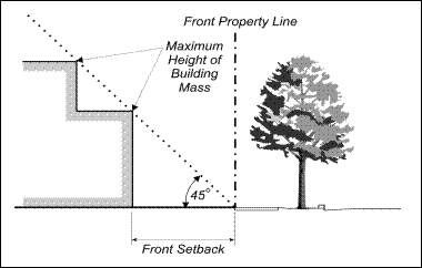
(Ord. No. 2108 § 1; Ord. No. 2183 § 3, 2009; Ord. No. 2190 § 3, 2009; Ord. No. 2372 § 3, 2023; Ord. No. 2379 § 5 (Exh. A), 2023; Ord. No. 2386 § 5 (Exh. A), 2024; Ord. No. 2387 § 5 (Exh. A), 2024; Ord. No. 2394 § 4 (Exh. A), 2025; Ord. No. 2403 § 4 (Exh. A), 2025.)
36.220.050 Development of Small Nonconforming Residential Parcels.
The following standards apply to new and remodeled single-family dwellings on legal nonconforming parcels with an area of less than 10,000 square feet, except that all standards, except subsection F of this section (Lot Coverage), do not apply to hillside parcels (as defined by SPMC 36.340 (Hillside Protection)). These standards are intended to minimize the impacts of single-family dwelling alteration, construction, expansion, and replacement by maintaining the existing residential neighborhood character that might otherwise result in overbuilding on a small single-family parcel.
A. Design compatibility. Proposed construction shall have exterior colors, forms, and materials that are consistent throughout and visually compatible with adjacent structures and the surrounding neighborhood. The size, mass, and scale of new dwellings shall also be visually compatible with adjacent structures and the surrounding neighborhood. New dwellings shall also comply with the City’s Residential Design Guidelines.
B. Setbacks.
1. The front and rear setback shall be 20 feet, or 15 feet for houses with a front porch.
2. A second story shall be set back an additional five feet from the front of the house and three feet on both sides (which may be accommodated within a sloping roof), unless the architectural style requires a zero front or side second story setback, as determined by the Review Authority. In the latter case, the ground floor front setback shall be 25 feet.
C. Driveway width. Driveways shall be limited to a maximum paved width of 10 feet with two feet clear of obstructions on either side, or 40 percent of the parcel frontage, whichever is less. Driveway width at property lines shall be limited to 10 feet.
D. Front yard paving. No more than 45 percent of the total area of the front setback shall be paved for walkways, driveways, and/or other hardcover pavement.
E. Reserved.
F. Lot coverage. The maximum lot coverage shall be 50 percent.
G. Parking. For dwellings with detached garages located behind the primary unit, the minimum parking requirement shall be two covered spaces. Attached garages shall be set back a minimum of 10 feet from the front of the building, and shall include two enclosed spaces.
(Ord. No. 2108 § 1; Ord. No. 2166, § 3, 2007; Ord. No. 2183 § 4, 2009; Ord. No. 2190 § 5, 2009; Ord. No. 2379 § 5 (Exh. A), 2023.)
Division 36.230. Commercial Zoning Districts
Sections:
36.230.010 Purpose of Division.
36.230.020 Purposes of Commercial Zoning Districts.
36.230.030 Commercial District Land Uses and Permit Requirements.
36.230.040 Commercial District General Development Standards.
36.230.050 Mixed Use Overlay Development Standards.
36.230.010 Purpose of Division.
This division lists the uses of land that may be allowed within the commercial zoning districts established by SPMC 36.200.020 (Zoning Map and Zoning Districts). It also determines the type of zoning approval/approval required for each use, and provides basic standards for site development.
(Ord. No. 2108 § 1; Ord. No. 2379 § 5 (Exh. A), 2023.)
36.230.020 Purposes of Commercial Zoning Districts.
The Commercial zoning districts are intended to provide a range of commercial opportunities within South Pasadena. The purposes of the individual Commercial zoning districts and the manner in which they are applied are as follows.
A. CG (Commercial General) district. The CG zoning district is applied to areas appropriate for a wide range of commercial retail and service land uses. The CG zoning district is consistent with the Mixed Use Core land use designation of the General Plan.
B. CO (Commercial Office) district. The CO zoning district is applied to areas appropriate for professional offices. Other uses including business support services, restaurants, and specialty retail land uses may be allowed. The CO zoning district is consistent with the Mixed Use Core land use designation in the General Plan.
C. BP (Business Park) district. The BP zoning district is applied to areas appropriate for light manufacturing and business park uses including research and development, corporate headquarter offices, and support service and retail land uses. Land uses in the BP District are intended to be designed as campus-business park environments. The BP zoning district is consistent with the Mixed Use Core land use designation of the General Plan.
D. MU (Mixed Use) overlay district. The MU overlay district may be applied to all CO, CG, and BP zoning districts as an overlay to allow for a wide range of development that contains a mix of functions, including commercial, entertainment, office, and housing. The MU overlay district is consistent with the Mixed Use Core land use designation in the General Plan. The intent of this overlay district includes implementation of General Plan policy direction and applicable State laws to allow for 100 percent residential development in the CO and CG zoning districts.
(Ord. No. 2108 § 1; Ord. No. 2379 § 5 (Exh. A), 2023.)
36.230.030 Commercial District Land Uses and Permit Requirements.
A. General requirements. Table 2-4 identifies the uses of land allowed by this Zoning Code in the commercial zoning districts, and the zoning approval required to establish each use, in compliance with SPMC 36.210.030 (Allowable Land Uses and Permit Requirements).
Note: where the last column in the tables (“Specific Use Regulations”) includes a section number, the regulations in the referenced section apply to the use; however, provisions in other sections of this Zoning Code may also apply.
B. Design guidelines and standards. Land uses and structures proposed within the commercial zoning districts shall comply with any adopted design guidelines to the extent required by the Review Authority and/or specific provisions of any design guidelines and any applicable objective design standards for qualifying residential and mixed-use projects. Qualifying residential projects shall comply with the ministerial approval process established by SPMC 36.410.040(D)(6).
|
TABLE 2-4. ALLOWED USES AND PERMIT REQUIREMENTS FOR COMMERCIAL & BUSINESS PARK DISTRICTS |
P |
|||
|---|---|---|---|---|
|
CUP |
Conditional Use Permit required |
|||
|
AUP |
Administrative Use Permit required |
|||
|
— |
Use not allowed |
|||
|
|
PERMIT REQUIREMENT BY ZONE |
Specific Use Regulations |
||
|
LAND USE (1) |
CO |
CG |
BP |
|
|
MANUFACTURING & PROCESSING USES |
||||
|
— |
— |
P |
|
|
|
— |
— |
P |
|
|
|
— |
— |
P |
|
|
|
Handcraft industries, small-scale manufacturing, less than 3,500 sf |
— |
— |
P |
|
|
Handcraft industries, small-scale manufacturing, 3,500 sf or more |
— |
— |
CUP |
|
|
Laundries and dry cleaning plants, less than 3,500 sf |
— |
— |
P |
|
|
Laundries and dry cleaning plants, 3,500 sf or more |
— |
— |
CUP |
|
|
Media postproduction facilities |
— |
— |
P |
|
|
Metal products fabrication, machine/welding shops |
— |
— |
P |
|
|
Photographic processing plants, less than 3,500 sf |
— |
— |
P |
|
|
Photographic processing plants, 3,500 sf or more |
— |
— |
CUP |
|
|
Plumbing and heating shops, less than 3,500 sf |
— |
— |
P |
|
|
Plumbing and heating shops, 3,500 sf or more |
— |
— |
CUP |
|
|
Printing and publishing, less than 3,500 sf |
— |
P |
P |
|
|
Printing and publishing, 3,500 sf or more |
— |
P |
CUP |
|
|
— |
CUP |
CUP |
36.350.160 |
|
|
Recycling facilities—Reverse vending machines |
— |
P |
P |
36.350.160 |
|
— |
— |
P |
|
|
|
RECREATION, EDUCATION & PUBLIC ASSEMBLY USES |
||||
|
Adult entertainment businesses |
— |
— |
(2) |
36.350.030 |
|
Clubs, lodges, fraternal organizations |
— |
CUP |
CUP |
|
|
Indoor amusement/entertainment facilities |
— |
P |
CUP |
|
|
— |
AUP |
CUP |
|
|
|
— |
CUP |
CUP |
|
|
|
Schools—Private |
— |
CUP |
CUP |
|
|
Schools—Specialized education, tutoring, and training |
— |
AUP/ CUP |
CUP |
3,000 sf or smaller requires an AUP, greater than 3,000 sf requires a CUP |
|
— |
CUP |
CUP |
|
|
|
Studios/health/fitness facility—Dance, martial arts, music, photography, etc. |
AUP/ CUP |
AUP/ CUP |
CUP |
3,000 sf or smaller requires an AUP, greater than 3,000 sf requires a CUP |
|
— |
CUP |
— |
|
|
|
CUP |
CUP |
CUP |
36.350.230 |
|
|
RESIDENTIAL USES |
||||
|
— |
CUP |
P |
36.350.250 |
|
|
— |
— |
— |
36.350.110 |
|
|
P |
P |
P |
36.230.050 |
|
|
Multifamily dwellings (5) |
P |
P |
P(6) |
36.230.050 |
|
Single-room occupancy |
— |
— |
P |
36.350.260 |
|
Transitional and supportive housing, including low barrier navigation centers |
P |
P |
P |
|
|
RETAIL TRADE |
|
|
|
|
|
— |
CUP |
— |
36.350.040 |
|
|
— |
P |
— |
|
|
|
— |
CUP |
CUP |
|
|
|
— |
P |
CUP |
36.350.220 |
|
|
Coffee roasting and packaging, retail |
— |
CUP |
— |
|
|
— |
CUP |
CUP |
|
|
|
Convenience and liquor stores |
— |
CUP |
— |
36.350.040 |
|
— |
P |
— |
|
|
|
— |
CUP |
CUP |
|
|
|
Extended hour businesses (11:00 p.m. to 6:00 a.m.) |
— |
CUP |
CUP |
|
|
Furniture, furnishings and appliance stores |
— |
P |
— |
|
|
— |
CUP |
CUP |
|
|
|
— |
P |
CUP |
36.350.140, 36.350.220 |
|
|
— |
AUP |
— |
|
|
|
Hardware stores |
— |
P |
— |
|
|
Multi-tenant retail |
— |
CUP |
— |
|
|
— |
AUP |
CUP |
|
|
|
— |
P |
— |
36.350.140, 36.350.220 |
|
|
CUP |
P |
P |
|
|
|
Restaurants, multi-tenant retail |
|
CUP(3) |
|
|
|
Restaurants, take-out and with accessory retail food |
CUP |
P |
P |
|
|
Restaurants, with catering and/or accessory retail food |
CUP |
CUP |
CUP |
|
|
Restaurants, with outdoor dining only |
AUP |
AUP |
AUP |
36.350.130 |
|
Secondhand stores |
— |
P |
— |
|
|
Tobacco retailer—Primary use |
— |
P |
CUP |
SPMC Chapter 18, Article 6 or its successor |
|
Tobacco retailer—Accessory use |
— |
As required for the primary use that the accessory use is associated with |
As required for the primary use that the accessory use is associated with |
|
|
— |
CUP |
— |
36.350.220 |
|
|
SERVICES—BUSINESS & PROFESSIONAL |
||||
|
Automated teller machines (ATMs) |
P |
P |
P |
36.350.060 |
|
— |
P |
P |
|
|
|
— |
CUP |
P(4) |
|
|
|
Offices—Production, research and development |
P |
P |
P |
|
|
Offices—Professional and administrative |
P |
P |
P |
|
|
SERVICES—OTHER |
||||
|
— |
CUP |
CUP |
|
|
|
CUP |
CUP |
— |
|
|
|
Child/adult day care centers |
— |
AUP/ CUP |
CUP |
3,000 sf or smaller requires an AUP, greater than 3,000 sf requires a CUP |
|
— |
— |
CUP |
|
|
|
P |
P |
P |
|
|
|
Hotels and motels |
— |
CUP |
— |
|
|
— |
CUP |
— |
|
|
|
— |
CUP |
P |
|
|
|
P |
P |
P |
|
|
|
— |
CUP |
— |
SPMC 17.15(B) |
|
|
CUP |
P |
— |
SPMC 17.13 |
|
|
— |
AUP |
— |
|
|
|
Vehicle repair and maintenance—Major repair work |
— |
CUP |
— |
|
|
Vehicle repair and maintenance—Service and maintenance |
— |
CUP |
— |
|
|
Veterinary clinics, hospitals, kennels |
— |
CUP |
CUP |
|
|
— |
P |
P |
|
|
|
TRANSPORTATION & COMMUNICATIONS |
||||
|
— |
CUP |
— |
|
|
|
— |
CUP |
P |
|
|
|
CUP |
CUP |
CUP |
36.350.210 |
|
|
Notes: (1) See Article 7 for land use definitions. (2) Requires an adult business permit in compliance with SPMC 36.350.030. (3) If multi-tenant retail complies with the parking regulations in SPMC 36.310.040, a CUP is required if a new restaurant would cause the restaurant square footage in the multi-tenant retail to exceed 20 percent of the total square footage. If the multi-tenant retail is legal nonconforming with the parking regulations in SPMC 36.310.040, a CUP is required if a restaurant use in an existing space has been abandoned for a period of 18 months or longer, and for all additional restaurants in new spaces or spaces previously occupied by a non-restaurant. (4) Business support services consisting of laboratory uses require a CUP. (5) See SPMC 36.230.050 regarding properties identified as housing sites in the General Plan Housing Element sites inventory as Mixed Use. (6) Residential units shall be located above the ground-floor level. |
||||
(Ord. No. 2108 § 1; Ord. No. 2128 § 1; Ord. No. 2132 § 1; Ord. No. 2165 § 1, 2007; Ord. No. 2172 § 3, 2008; Ord. No. 2183 § 5, 2009; Ord. No. 2197 § 3, 2009; Ord. No. 2202 § 3, 2010; Ord. No. 2207 § 5, 2010; Ord. No. 2208 § 6, 2010; Ord. No. 2244 § 5, 2013; Ord. No. 2251 § 4, 2013; Ord. No. 2292 § 5, 2016; Ord. No. 2358 § 1, 2021; Ord. No. 2372 § 4, 2023; Ord. No. 2379 § 5 (Exh. A), 2023.)
36.230.040 Commercial District General Development Standards.
Subdivisions, new land uses and structures, and alterations to existing land uses and structures, shall be designed, constructed, and/or established in compliance with the requirements in Table 2-5, in addition to the applicable development standards (e.g., landscaping, parking and loading, etc.) in Article 3 (Site Planning and General Development Standards).
|
TABLE 2-5. COMMERCIAL DISTRICT GENERAL DEVELOPMENT STANDARDS |
|||
|---|---|---|---|
|
Development Feature |
Requirement by Zoning District |
||
|
CO |
CG |
BP |
|
|
Minimum lot size |
Minimum area and width for parcels proposed in new subdivisions. |
||
|
Area |
10,000 sf |
||
|
Width |
50 ft |
||
|
Minimum setbacks required. See SPMC 36.300.030 for setback measurement, allowed projections into setbacks, and exceptions to setbacks. |
|||
|
Front |
10 ft |
None required |
None required |
|
Sides, each |
4 ft; an additional 1 ft setback shall be provided for each story above the second story. (3-story building = 5 ft. 4-story building = 6 ft, etc.) |
None required |
None required |
|
Street side |
None required |
None required |
|
|
Rear |
None, except if adjacent to an alley 5 ft, or if adjacent to a RS district 25 ft |
None required |
None required |
|
Maximum percentage of total lot area that may be covered by structures. |
|||
|
No maximum |
50% |
||
|
Height limit |
Maximum allowable height of structures. See SPMC 36.300.040 (Height Limits and Exceptions) for height measurement requirements. |
||
|
Maximum height |
35 ft |
||
|
As required by SPMC 36.330 (Landscaping Standards) |
|||
|
Parking |
As required by SPMC 36.310 (Parking and Loading) |
||
|
As required by SPMC 36.320 (Signs) |
|||
(Ord. No. 2108 § 1; Ord. No. 2379 § 5 (Exh. A), 2023; Ord. No. 2403 § 4 (Exh. A), 2025.)
36.230.050 Mixed Use Overlay District Development Standards.
A. New development. Subdivisions, new land uses, and structures developed as mixed-use development or as urban residential (multifamily) development within CO, CG, or BP zoning districts and with the Mixed Use Overlay shall be designed, constructed, and/or established in compliance with the requirements in Table 2-6, in addition to the applicable development standards (e.g., landscaping, parking and loading, etc.) in Article 3 (Site Planning and General Development Standards).
B. For properties designated in the General Plan Housing Element sites inventory as Mixed Use, in addition to all other requirements in this section, projects of 100 percent residential development shall be permitted, and at least 50 percent of the total floor area of mixed-used developments on any sites identified as Mixed Use in the Housing Element sites inventory must be developed as residential use.
C. Redevelopment. Substantial alteration of an existing mixed-use development or urban residential (multi-family) development within the CO, CG, or BP zoning districts shall be improved to satisfy the requirements in Table 2-6, in addition to the applicable development standards (e.g., landscaping, parking and loading, etc.) in Article 3 (Site Planning and General Development Standards).
D. Notes column in Table 2-6. Where the last column in Table 2-6 (“Notes”) includes a section number, the regulations in the referenced section apply to the standard; however, provisions in other sections of this Zoning Code may also apply.
|
TABLE 2-6. MIXED USE OVERLAY DISTRICT DEVELOPMENT STANDARDS |
||
|---|---|---|
|
Development Feature |
Requirement |
Notes |
|
DEVELOPMENT INTENSITY |
||
|
Minimum Size or Area |
20,000 sf |
Minimum area for parcels proposed for new subdivisions. |
|
Minimum Lot Frontage |
80 ft |
Minimum width for parcels proposed for new subdivisions. |
|
Density Range for Residential |
52 to 70 du/ac |
|
|
Maximum Lot Coverage |
|
|
|
Minimum Residential Unit Size |
|
|
|
NONRESIDENTIAL USES |
||
|
Location |
Nonresidential uses are required along the street frontage in the areas described in the General Plan for development within a Corridor, District, or Neighborhood Centers. |
|
|
BUILDING HEIGHT AND FORM |
||
|
Maximum Height |
55 feet (see SPMC 36.300.040(A)) |
Nonhabitable building features such as chimneys, cupolas, flagpoles, monuments, steeples, pitched roofs, screened equipment, roof access stairs, elevator rooms and shafts, elevator overruns, and similar structures or projections shall be contained within the height limit as set forth in SPMC 36.300.040(A). |
|
Maximum Stories |
|
|
|
Maximum Floor Area by Story |
|
|
|
Maximum Facade Length |
100 ft |
A minimum building break of 10 feet wide by 10 feet deep is required so as to prevent facade lengths longer than 100 feet. |
|
BUILDING RELATIONSHIP TO STREET |
||
|
Minimum Building Frontage |
60% |
|
|
Maximum Elevation of Building Entry Above the Street/Sidewalk Level and Maximum Recess Below the Street/Sidewalk Level |
2 ft |
Entries into individual residential units may be located up to 4 feet above the street/sidewalk level. |
|
Minimum Ground Floor Height |
12 ft |
|
|
NONRESIDENTIAL USE GROUND FLOOR BUILDING DESIGN |
||
|
Maximum Blank Wall Length |
25 ft |
|
|
Minimum Glazing |
50% |
|
|
Minimum Tenant Space Width |
25 ft |
|
|
Minimum Number of Entries |
1 per 100 lineal ft |
|
|
Minimum Wall Plane Articulation |
To/from window/door—minimum 6 inches To/from column/other feature—minimum 18 inches |
Windows, door, columns, and other features shall be recessed or project forward to provide the respective minimum differential from the wall plane |
|
As required by SPMC 36.320 (Signs) |
|
|
|
SETBACKS FOR NONRESIDENTIAL |
||
|
Front—Ground Floor |
Per the underlying zoning district |
|
|
Side—Ground Floor |
Per the underlying zoning district |
|
|
Rear |
15 ft |
|
|
SETBACKS FOR RESIDENTIAL |
||
|
Front—Ground Floor |
5 ft in CG district 7.5 ft in other than CG district |
|
|
Side |
4 ft; an additional 1 ft setback shall be provided for each story above the second story (i.e., 3-story building = 5 ft. 4-story building = 6 ft, etc.) |
|
|
Rear |
10 ft, or 5 ft abutting an alley |
|
|
PARKING, LOCATION AND DESIGN(1) |
||
|
Site Access/Driveway Location |
The location of site access/driveways shall be prioritized as follows: (1) From an alleyway, (2) From a side street, or (3) If the previous two locations are infeasible as determined by the Director, then access from the front shall be limited to a maximum 24-ft wide driveway. |
|
|
Location of Parking Spaces/Areas |
The location of parking spaces/areas shall be limited as follows: (1) Located to the rear of the building on the ground level or underground, and (2) Shall not be located above the ground level or within 30 feet of the front or side street property line, and (3) Parking may be placed within setback areas below grade. |
|
|
Number of Spaces for Nonresidential Uses |
As required by SPMC 36.310 (Parking and Loading) |
Shared parking or a reduction in parking subject to approval of a parking study—SPMC 36.310.060. Within one-half mile of a high-quality transit station, no parking minimums shall apply for any use except for hotels, motels, bed and breakfast inns, and similar transient lodging facilities per Government Code Section 65863.2. |
|
Number of Spaces for Residential Uses |
Studio—0.50 space One-bedroom—1 space Two-bedroom—1.5 spaces Guest Space—not required |
Parking is reduced, not required, for qualifying development projects within one-half mile of a major transit stop, as defined in Government Code Section 65863.2. |
|
Design of Surface or Structure Parking |
As required by SPMC 36.310 (Parking and Loading) |
Unless modified by standards herein |
|
LANDSCAPING AND OPEN SPACE |
||
|
Minimum Site Landscaping |
12% |
|
|
Minimum Driveway and Parking Area Side Landscaping |
5 ft |
|
|
Minimum Total Combined Useable Open Space per Residential Unit (Common and Private Combined) |
200 sf/du |
Improved rooftop open space, balconies, and indoor common spaces can be counted toward usable open space. |
|
Common Open Space Requirements |
1,000 sf area minimum 25 ft minimum depth and width
50% minimum of the “minimum total combined useable open space” requirement above; 1,000 sf minimum, a minimum of 20 feet in two directions |
Up to 25% of the required common open space may be indoor common open space such as fitness rooms, resident lounges and similar or typical facilities. Mail rooms and leasing offices and associated areas do not count towards the required common open space.
A minimum of 20% of outdoor common open space shall be landscaped with pervious plant materials that are permanently maintained and irrigated and may count toward the minimum site landscaping requirement. Outdoor open space shall comply with SPMC 36.180(D)(1) (General Landscape Standards) |
|
Private Open Space Requirements |
Less than 50% of the total required open space. Private open space shall be 8 ft in width and 6 ft in depth to count towards the area requirements. |
Individual balconies, ground floor patios, porches, or similar private open space may be provided to meet the area requirements. |
|
Notes: (1) Guest parking spaces shall be clearly marked for guest parking only and are encouraged to be evenly dispersed throughout the development site. Signs shall be provided at appropriate locations to direct visitors to guest parking locations. |
||
(Ord. No. 2379 § 5 (Exh. A), 2023; Ord. No. 2394 § 4 (Exh. A), 2025; Ord. No. 2403 § 4 (Exh. A), 2025.)
Division 36.240. Special Purpose Zoning Districts
Sections:
36.240.010 Purpose of Division.
36.240.020 Purposes of Special Purpose Zoning Districts.
36.240.030 Special Purpose District Land Uses and Permit Requirements.
36.240.040 Special Purpose District General Development Standards.
36.240.010 Purpose of Division.
This division regulates development and new land uses in the special purpose zoning districts established by SPMC 36.200.020 (Zoning Map and Zoning Districts).
(Ord. No. 2108 § 1; Ord. No. 2379 § 5 (Exh. A), 2023.)
36.240.020 Purposes of Special Purpose Zoning Districts.
The purposes of the individual special purpose zoning districts and the manner in which they are applied are as follows.
A. CF (Community Facilities) District. The CF zoning district is applied to areas appropriate for public and quasi-public land uses. Typical land uses include government and institutional offices, schools, libraries, religious facilities, and other related municipal uses. The CF zoning district is consistent with the Civic land use designation of the General Plan.
B. OS (Open Space) District. The OS zoning district is applied to areas suitable for open space land uses including parks, natural open space areas, recreational facilities, and areas used for flood control. The OS zoning district is consistent with the Parks and Open Spaces, and Preserves land use designations of the General Plan.
C. DTSP (Downtown Specific Plan) District. The DTSP zoning district is applied to the Downtown Specific Plan area. Appropriate land uses include pedestrian-oriented, retail and service uses. The DTSP zoning district is consistent with the Mixed Use Core and Fair Oaks Corridor land use designations of the General Plan.
D. HFSP (Holy Family Specific Plan) District. The HFSP zoning district is applied to the Holy Family Specific Plan area. Appropriate land uses include religious facilities, schools, and accessory uses. The HFSP zoning district is consistent with the Civic land use designation of the General Plan.
(Ord. No. 2108 § 1; Ord. No. 2379 § 5 (Exh. A), 2023.)
36.240.030 Special Purpose District Land Uses and Permit Requirements.
A. CF and OS Districts. Table 2-7 identifies the uses of land allowed by this Zoning Code in each special purpose zoning district, and the zoning approval required to establish each use, in compliance with SPMC 36.210.030 (Allowable Land Uses and Permit Requirements).
Note: where the last column in the tables (“Specific Use Regulations”) includes a section number, the regulations in the referenced section apply to the use; however, provisions in other sections of this Zoning Code may also apply.
B. DTSP District. Land uses in the DTSP zoning district are as permitted in the Downtown Specific Plan.
C. HFSP District. Land uses in the HFSP zoning district are as permitted in the Holy Family Specific Plan.
D. CF-50 District.
1. Purpose. The CF-50 District is intended to provide opportunities for higher intensity multifamily housing on religious congregation or private school sites that are larger than two acres and designated CF-50.
2. Applicability. The CF-50 District shall consist of those parcels designated CF-50 on the City’s Zoning Map.
3. Allowable Density and Height. Maximum 50 dwelling units per acre with a maximum height of up to 50 feet.
4. Allowable land uses and development standards. Allowable land uses shall be as in the CF District, except that multifamily residential development is permitted. Multifamily residential uses shall be subject to the Mixed Use Overlay District Development Standard of SPMC 36.230.050(D) and Table 2-6, except for the maximum height limit.
|
TABLE 2-7. ALLOWED USES AND PERMIT REQUIREMENTS FOR SPECIAL PURPOSE ZONING DISTRICTS |
P |
||
|---|---|---|---|
|
CUP |
Conditional Use Permit required |
||
|
AUP |
Administrative Use Permit required |
||
|
— |
Use not allowed |
||
|
PERMIT REQUIRED BY DISTRICT |
Specific Use Regulations |
||
|
LAND USE (1) |
CF (2) (3) |
OS |
|
|
AGRICULTURE & OPEN SPACE USES |
|||
|
CUP |
CUP |
36.350.230 |
|
|
Hiking trails |
— |
P |
|
|
Nature preserves and accessory uses (e.g., interpretive centers) |
— |
P |
|
|
RECREATION, EDUCATION & PUBLIC ASSEMBLY USES |
|||
|
P |
AUP |
|
|
|
Equestrian facilities |
— |
AUP |
|
|
P |
— |
|
|
|
Schools, private |
AUP |
— |
|
|
Outdoor recreational facilities |
P |
AUP |
|
|
P |
AUP |
|
|
|
Religious institutions |
CUP |
— |
|
|
SERVICES |
|
|
|
|
Medical services – Hospitals |
CUP |
— |
|
|
TRANSPORTATION & COMMUNICATIONS |
|||
|
CUP |
— |
|
|
|
CUP |
CUP |
36.350.210 |
|
|
Notes: (1) See Article 7 for land use definitions. (2) Residential development with a density between 20 and 30 dwelling units per acre is allowed on Assessor Parcel No. 5314-003-083 pursuant to the 2021-2029 (6th Cycle) Housing Element. Any project on this parcel that includes at least 20 percent of the residential units reserved for lower income households shall (a) be processed through a ministerial approval process, (b) qualify for priority processing as compared to other projects processed by the Community Development Department, and (c) be exempt from and not subject to the Public Art Program and Public Art Development requirements of SPMC 36.390 and 36.395. (3) See also SPMC 36.240.030(D) pertaining to the CF-50 District. |
|||
(Ord. No. 2108 § 1; Ord. No. 2127, § 1; Ord. No. 2197 § 4, 2009; Ord. No. 2379 § 5 (Exh. A), 2023; Ord. No. 2388 § 8, 2024; Ord. No. 2403 § 4 (Exh. A), 2025.)
36.240.040 Special Purpose District General Development Standards.
A. CF and OS Districts. Subdivisions, new land uses and structures, and alterations to existing land uses and structures, shall be designed, constructed, and/or established in compliance with development standards determined through development review process on a case-by-case basis, and may include buffering between structures and adjacent residential uses, in addition to any other applicable requirements of this division, and the development standards (e.g., landscaping, parking and loading, etc.) in Article 3 (Site Planning and General Development Standards).
B. DTSP District. Development standards that pertain to development in the DTSP District are as specified in the Downtown Specific Plan.
C. HFSP District. Development standards that pertain to development in the HFSP District are as specified in the Holy Family Specific Plan.
D. Design guidelines and standards. Land uses and structures proposed within the special purpose zoning districts shall comply with any adopted design guidelines to the extent required by the appropriate Review Authority and/or specific provisions of the design guidelines, and any applicable objective design standards for qualifying residential and mixed-use projects.
(Ord. No. 2108 § 1; Ord. No. 2183 § 6, 2009; Ord. No. 2379 § 5 (Exh. A), 2023.)
Division 36.250. Overlay Zoning Districts
Sections:
36.250.010 Purpose of Division.
36.250.020 Applicability of Overlay Zoning Districts.
36.250.030 Altos de Monterey (AM) Overlay District.
36.250.040 Mixed Use (MU) Overlay District.
36.250.050 Housing Opportunity (HO) Overlay District.
36.250.060 Camino del Cielo (CDC) Overlay District.
36.250.010 Purpose of Division.
This Division regulates new and existing structures and land uses in the overlay zoning district established by Section 36.200.020 (Zoning Map and Zoning Districts). The provisions of this Division provide guidance for development in addition to the standards and regulations of the primary zoning district, where important site, environmental, safety, compatibility, or design issues require particular attention in project planning.
(Ord. No. 2108 § 1.)
36.250.020 Applicability of Overlay Zoning Districts.
The provisions of this Division apply to proposed land uses and development in addition to all other applicable requirements of this Zoning Code. Any perceived conflict between the provisions of this Division and any other provision of this Zoning Code shall be resolved in compliance with Division 36.110 (Interpretation of Zoning Code Provisions).
A. Mapping of overlay districts. The applicability of any overlay zoning district to a specific site is shown by the overlay Zoning Map symbol established by Section 36.200.020 (Zoning Map and Zoning Districts), being appended as a suffix to the symbol for the primary zoning district on the Zoning Map. The overlay districts are applied to property through the rezoning process (Division 36.620).
B. Allowed land uses, permit requirements, development standards. Except as may be otherwise provided by this Division for a specific overlay district:
1. Any land use normally allowed in the primary zoning district by this Article may be allowed within an overlay district, subject to any additional requirements of the overlay district;
2. Development and new land uses within an overlay district shall obtain the zoning approvals required by this Article for the primary zoning district; and
3. Development and new land uses within an overlay district shall comply with all applicable development standards of the primary zoning district, all other applicable provisions of this Zoning Code (e.g., Article 3—Site Planning and General Development Standards), and any adopted design guidelines to the extent determined by the appropriate Review Authority and/or specific provisions of the design guidelines.
(Ord. No. 2108 § 1; Ord. No. 2183 § 7, 2009.)
36.250.030 Altos de Monterey (AM) Overlay District.
A. Purpose. The standards and conditions provided by this Section for the AM Overlay District are intended to:
1. Maintain the existing architectural character and neighborhood environment;
2. Recognize, maintain, and augment the standards and conditions of the strict Covenants, Conditions, and Restrictions (CC&Rs) to which the properties within this overlay district are held and conveyed, and which run with the land; and
3. Provide additional conditions and restrictions not addressed by the CC&Rs that are necessitated by the long term residential use of the affected properties, also to maintain the existing architectural character and neighborhood environment.
The AM overlay district is consistent with the Altos de Monterey land use category of the General Plan.
B. Applicability.
1. Area affected. The AM overlay district is applied to areas identified on the zoning map indicated with the AM overlay district suffix symbol. These areas specifically include Parcels 1 through 57, Parcels 59-639, and Lot 3 of PM 7380, Tract 25588, as designated and recorded in Book 713, pages 51-77 inclusive of maps in the Office of the Los Angeles County Recorder (hereinafter described as either Tract 25588 or the AM overlay district.
2. Applicability of standards. The standards of this Section apply to any additions, remodels or new construction proposed in the AM overlay district, in addition to all other applicable requirements of this Zoning Code.
C. Allowable land uses and permit requirements. Land uses within the AM overlay district shall be limited to the following.
1. Permitted uses. Only the following uses are permitted within the AM overlay district.
a. One single-family dwelling is allowed on each legally subdivided lot not otherwise designated for semi-public or public use, subject to Planning Clearance (Section 36.410.020) and Design Review (Section 36.410.040). All structures shall be constructed on site, except that manufactured homes as defined in Government Code Section 65852.3 shall be permitted to the extent required by the Government Code.
b. Public or semi-public open space currently maintained on Lots 117 (Lot 3 of Parcel Map 7380), 488 and 489 of Tract 25588 (“Open Space Lots”) shall be zoned and designated in the General Plan as open space in perpetuity.
c. Trash containers, including recycling containers, may be placed forward of the required front yard setback for a maximum of 24 hours per week, immediately preceding and following trash pick-up.
d. Accessory structures not exceeding 600 square feet (except for garages and carports) provided that no kitchen, sleeping or restroom facilities are provided (except that an unenclosed gazebo may have an “outdoor kitchen” (grill, sink, wet bar, etc)); and they are not used for separate residential purposes. A lot with a permanent (requires a construction permit/s) swimming pool or spa pool may have a poolhouse or cabana with a sink and/or shower and/or toilet. When a poolhouse has a toilet, a covenant shall be required stating that the poolhouse shall be maintained as an accessory structure and not be used for sleeping quarters or be converted to a residential use. The purpose of the covenant is to ensure that subsequent owners of the property are aware of this restriction. This covenant shall be recorded against the property’s title, and evidence of recordation shall be provided to the Planning and Building Department prior to the issuance of a construction permit.
e. The accessory storage of building materials during on-site construction and for a maximum of 30 days after the completion of construction.
f. Private athletic facilities and swimming pools.
g. Washer/dryer hookups (water and gas supply and sewer connection) and/or a hand or utility sink, and a water heater in an attached or detached garage, subject to SPMC 36.350.170(B)(3).
2. Conditional uses. The following accessory uses may be allowed subject to Conditional Use Permit approval.
a. Temporary facilities not related to on-site construction, nor for residential purposes.
b. The temporary use of trailers or motor homes.
c. Second dwelling units in compliance with Section 36.350.200.
d. Amateur radio antennas taller than 15 feet.
e. Community gardens in compliance with Section 36.350.230.
D. Development standards. Proposed development and new land uses shall comply with the requirements in Table 2-7, and the following.
1. Subdivision. The subdivision of any existing lot within the tract shall be prohibited; provided that lot mergers and minor lot line adjustments may be allowed in compliance with Table 2-7.
2. Utilities. In recognition of the design of tract infrastructure, new hookup of plumbing, natural gas, or electric service from lots outside of the tract to any of these services within the tract shall be prohibited.
E. Design Review criteria. In addition to making the findings required for Design Review by Section 36.410.040 (Design Review), the appropriate Review Authority shall also consider the following guidelines before any application may be approved:
1. The scale of the proposed building, design height and mass in relation to the street frontage, to all setbacks and surrounding existing property;
2. The relation of existing adjoining building heights and their views;
3. The relation of proposed building heights to the existing topography;
4. The impact on surrounding properties; and
5. The obstruction of sunlight to the existing adjoining residences.
F. Nonconformities. Nonconforming uses, structures, and lots within the AM overlay zone are subject to the requirements of SPMC 36.360.120 (Altos de Monterey Nonconforming Use Provisions).
|
TABLE 2-7. AM OVERLAY DISTRICT DESIGN AND DEVELOPMENT STANDARDS |
|
|---|---|
|
Development Feature |
Requirement |
|
Minimum lot size |
Minimum area and width for new parcels. |
|
Area and width |
As shown on Final Tract Map 25588, except for mergers and lot line adjustments, provided that such actions shall not cause any significant gain or loss in the area of the tract. The subdivision of any existing lot is prohibited. |
|
Minimum lot size (Continued) |
|
|
Width, flag lot “pole” |
30 ft; frontage width may be 25 feet for parcels 306 and 307 to accommodate a 10-foot-wide path parallel to the flag lot stem. |
|
Minimum setbacks required, except as provided by SPMC 36.300.030 (Setback Measurement and Exceptions) |
|
|
Front and side |
See Table 2-8 (AM Overlay Setback Requirements). The side setback requirements in the table identify each side (i.e., 15'-5' means 15 ft on one side and 5 ft on the other). |
|
Rear |
25 ft |
|
Second story |
20 ft from the front setback line |
|
Between structures |
10 ft |
|
Sight distance |
Intersection: no visual obstructions between 2 and 6 feet above the ground on corner lots measured 25 feet across street corner. Driveways: no visual obstruction between 2 and 6 feet above the ground within 10 feet of a driveway and street. |
|
40% maximum |
|
|
0.35 for main building area of multi-floor structures, maximum |
|
|
Minimum floor area |
1,250 sf for each dwelling |
|
Height limit |
Maximum height of structures, measured from a point 6 inches above the high point of the existing grade line at the existing, previously set front yard setback line to the highest point of the roof or parapet wall. All heights shall be measured at any point along the building line. |
|
25 ft |
|
|
15 ft |
|
|
Fences |
Front yard—2 ft within a sight distance area, 3 ft elsewhere; side and rear yards—6 ft. Fence height includes garden walls, shrubs and hedges. |
|
As required by Division 36.330 (Landscaping Standards). No impervious surface shall be allowed in a required front or street side setback area, except for a driveway or approved drainage structure. All trees shall comply with the requirements of Ordinance No. 1991. |
|
|
Parking and loading |
• Dwellings require 3 off-street spaces (2 in a garage or carport), that are a minimum of 10 ft wide by 20 ft long, and entirely located to the rear of the front setback line. • No vehicle, trailer, boat or component thereof shall be stored on any parking space or driveway, or access thereto, except in a garage or carport, or behind a solid wall or fence that screens the stored object from public view. • No vehicle, trailer, boat, or component thereof, or other object shall be parked or stored for more than 72 hours in any required setback. • Garage door openings should not face the street when feasible, as determined by the review authority. |
|
Driveway requirements |
|
|
Width |
9 feet minimum, 12 feet maximum. Flag lots:10 feet minimum, 20 feet maximum |
|
Circular driveway restrictions |
Minimum lot width 80 ft; may occupy a maximum of 40% of the front yard area. |
|
Drainage |
Lots shall drain to the street. Drainage patterns established at the time of original lot grading shall not be disturbed except through the installation of conveyances approved by the City that conduct all surface runoff to the nearest public street or public drainage structure. |
|
Grading—Cut and fill |
2:1 maximum slope |
|
Fences and walls |
Garden fences and walls. Maximum height shall not exceed 6 ft along any property line or within any required setback, except for front yard and street side setback areas where the maximum height shall not exceed 36 inches. Trees or shrubs planted to achieve the same effect as a garden fence or wall shall also comply with these height limitations. Retaining walls. Retaining wall height shall not exceed 6 feet. Where more than one wall is built, the walls shall be separated by a distance equal to the wall height. |
|
Mechanical equipment |
Roof-mounted equipment may be allowed in accordance with SPMC 36.300.080(B). All plumbing vents shall not be visible from the street frontage. Ground-mounted HVAC equipment shall be screened from public view. Antennas and satellite dishes are exempt from these requirements. |
|
No more than one commercial sign with a maximum area of 6 square feet shall be displayed on any lot; noncommercial signs are not subject to this limitation. |
|
(Ord. No. 2108 §1; Ord. No. 2183 § 8, 2009; Ord. No. 2190 § 6, 2009; Ord. No. 2197 § 7, 2009; Ord. No. 2203, § 3, 2010; Ord. No. 2394 § 4 (Exh. A), 2025.)
Table 2-8
AM Overlay Setback Requirements
|
Lot Number |
Front Setback |
Side Setback |
|---|---|---|
|
1 |
25’ |
15’-5’ |
|
2 |
20’ |
5’-5’ |
|
3 |
15’ |
5’-5” |
|
4 |
15’ |
5’-5’ |
|
5 |
15’ |
5’-5’ |
|
6 |
15’ |
5’-5’ |
|
7 |
15’ |
5’-5’ |
|
8 |
15’ |
7’-7’ |
|
9 |
15’ |
5’-5’ |
|
10 |
15’ |
5’-5’ |
|
11 |
15’ |
5’-5’ |
|
12 |
15’ |
5’-5’ |
|
13 |
20’ |
5’-5’ |
|
14 |
25’ |
5’-5’ |
|
15 |
25’ |
5’-5’ |
|
16 |
25’ |
5’-5’ |
|
17 |
25’ |
15’-5’ |
|
18 |
20’ |
5’-5’ |
|
19 |
20’ |
5’-5’ |
|
20 |
15’ |
5’-5’ |
|
21 |
15’ |
5’-5’ |
|
22 |
15’ |
5’-5’ |
|
23 |
15’ |
5’-5’ |
|
24 |
15’ |
5’-5’ |
|
25 |
15’ |
5’-5’ |
|
26 |
15’ |
5’-5’ |
|
27 |
15’ |
5’-5’ |
|
28 |
15’ |
5’-5’ |
|
29 |
15’ |
5’-5’ |
|
30 |
20’ |
5’-5’ |
|
31 |
20’ |
5’-5’ |
|
32 |
25’ |
5’-5’ |
|
33 |
25’ |
5’-5’ |
|
34 |
25’ |
5’-5’ |
|
35 |
20’ |
5’-5’ |
|
36 |
20’ |
15’-5’ |
|
37 |
20’ |
5’-5’ |
|
38 |
20’ |
5’-5’ |
|
39 |
20’ |
5’-5’ |
|
40 |
20’ |
5’-5’ |
|
41 |
20’ |
5’-5’ |
|
42 |
20’ |
5’-5’ |
|
43 |
20’ |
5’-5’ |
|
44 |
20’ |
5’-5’ |
|
45 |
25’ |
5’-5’ |
|
46 |
25’ |
5’-5’ |
|
47 |
20’ |
5’-5’ |
|
48 |
20’ |
5’-5’ |
|
49 |
20’ |
5’-5’ |
|
50 |
25’ |
5’-5’ |
|
51 |
25’ |
5’-5’ |
|
52 |
25’ |
15’-5’ |
|
53 |
20’ |
7’-7’ |
|
54 |
15’ |
5’-5’ |
|
55 |
15’ |
5’-5’ |
|
56 |
15’ |
5’-5’ |
|
57 |
15’ |
7’-7’ |
|
58 |
|
|
|
59 |
25’ |
15’-5’ |
|
60 |
25’ |
5’-5’ |
|
61 |
25’ |
5’-5’ |
|
62 |
25’ |
5’-5’ |
|
63 |
25’ |
5’-5’ |
|
64 |
20’ |
5’-5’ |
|
65 |
15’ |
5’-5’ |
|
66 |
15’ |
5’-5’ |
|
67 |
15’ |
5’-5’ |
|
68 |
15’ |
5’-5’ |
|
69 |
15’ |
5’-5’ |
|
70 |
15’ |
5’-5’ |
|
71 |
15’ |
7’-7’ |
|
72 |
15’ |
7’-7’ |
|
73 |
15’ |
7’-7’ |
|
74 |
25’ |
5’-5’ |
|
75 |
25’ |
15’-5’ |
|
76 |
25’ |
5’-5’ |
|
77 |
25’ |
5’-5’ |
|
78 |
25’ |
5’-5’ |
|
79 |
25’ |
5’-5’ |
|
80 |
25’ |
5’-5’ |
|
81 |
25’ |
7’-7’ |
|
82 |
25’ |
7’-7’ |
|
83 |
25’ |
5’-5’ |
|
84 |
25’ |
5’-5’ |
|
85 |
25’ |
5’-5’ |
|
86 |
25’ |
5’-5’ |
|
87 |
25’ |
15’-5’ |
|
88 |
25’ |
5’-5’ |
|
89 |
25’ |
7’-7’ |
|
90 |
25’ |
5’-5’ |
|
91 |
25’ |
5’-5’ |
|
92 |
25’ |
5’-5’ |
|
93 |
25’ |
5’-5’ |
|
94 |
25’ |
5’-5’ |
|
95 |
20’ |
5’-5’ |
|
96 |
25’ |
5’-5’ |
|
97 |
25’ |
5’-5’ |
|
98 |
25’ |
5’-5’ |
|
99 |
30’ |
5’-5’ |
|
100 |
25’ |
5’-5’ |
|
101 |
25’ |
5’-5’ |
|
102 |
25’ |
15’-5’ |
|
103 |
25’ |
5’-5’ |
|
104 |
25’ |
15’-5’ |
|
105 |
25’ |
5’-5’ |
|
106 |
25’ |
5’-5’ |
|
107 |
25’ |
5’-5’ |
|
108 |
25’ |
5’-5’ |
|
109 |
25’ |
5’-5’ |
|
110 |
25’ |
5’-5’ |
|
111 |
25’ |
5’-5’ |
|
112 |
25’ |
5’-5’ |
|
113 |
25’ |
15’-5’ |
|
114 |
25’ |
5’-5’ |
|
115 |
20’ |
5’-5’ |
|
116 |
20’ |
5’-5’ |
|
117 |
|
|
|
118 |
20’ |
5’-5’ |
|
119 |
20’ |
5’-5’ |
|
120 |
25’ |
5’-5’ |
|
121 |
25’ |
15’-5’ |
|
122 |
25’ |
5’-5’ |
|
123 |
25’ |
5’-5’ |
|
124 |
25’ |
5’-5’ |
|
125 |
25’ |
5’-5’ |
|
126 |
25’ |
5’-5’ |
|
127 |
25’ |
5’-5’ |
|
128 |
25’ |
5’-5’ |
|
129 |
25’ |
5’-5’ |
|
130 |
25’ |
5’-5’ |
|
131 |
25’ |
5’-5’ |
|
132 |
25’ |
5’-5’ |
|
133 |
25’ |
5’-5’ |
|
134 |
25’ |
15’-5’ |
|
135 |
25’ |
7’-7’ |
|
136 |
25’ |
5’-5’ |
|
137 |
25’ |
7’-7’ |
|
138 |
20’ |
7’-7’ |
|
139 |
20’ |
7’-7’ |
|
140 |
15’ |
7’-7’ |
|
141 |
15’ |
5’-5’ |
|
142 |
15’ |
5’-5’ |
|
143 |
15’ |
5’-5’ |
|
144 |
20’ |
7’-7’ |
|
145 |
20’ |
7’-7’ |
|
146 |
20’ |
5’-5’ |
|
147 |
25’ |
7’-7’ |
|
148 |
25’ |
7’-7’ |
|
149 |
25’ |
5’-5’ |
|
150 |
25’ |
5’-5’ |
|
151 |
25’ |
15’-5’ |
|
152 |
25’ |
15’-5’ |
|
153 |
25’ |
5’-5’ |
|
154 |
25’ |
7’-7’ |
|
155 |
25’ |
7’-7’ |
|
156 |
25’ |
7’-7’ |
|
157 |
20’ |
7’-7’ |
|
158 |
20’ |
7’-7’ |
|
159 |
25’ |
7’-7’ |
|
160 |
25’ |
7’-7’ |
|
161 |
25’ |
7’-7’ |
|
162 |
25’ |
7’-7’ |
|
163 |
20’ |
7’-7’ |
|
164 |
20’ |
7’-7’ |
|
165 |
25’ |
5’-5’ |
|
166 |
25’ |
7’-7’ |
|
167 |
15’ |
5’-5’ |
|
168 |
15’ |
5’-5’ |
|
169 |
25’ |
5’-5’ |
|
170 |
15’ |
5’-5’ |
|
171 |
25’ |
5’-5’ |
|
172 |
25’ |
7’-7’ |
|
173 |
25’ |
7’-7’ |
|
174 |
25’ |
5’-5’ |
|
175 |
25’ |
5’-5’ |
|
176 |
20’ |
5’-5’ |
|
177 |
25’ |
5’-5’ |
|
178 |
25’ |
5’-5’ |
|
179 |
20’ |
15’-5’ |
|
180 |
25’ |
5’-5’ |
|
181 |
25’ |
5’-5’ |
|
182 |
50’ |
5’-5’ |
|
183 |
38’ |
5’-5’ |
|
184 |
25’ |
5’-5’ |
|
185 |
25’ |
5’-5’ |
|
186 |
38’ |
5’-5’ |
|
187 |
38’ |
5’-5’ |
|
188 |
25’ |
5’-5’ |
|
189 |
25’ |
5’-5’ |
|
190 |
38’ |
5’-5’ |
|
191 |
36’ |
5’-5’ |
|
192 |
25’ |
5’-5’ |
|
193 |
25’ |
5’-5’ |
|
194 |
25’ |
15’-5’ |
|
195 |
25’ |
7’-7’ |
|
196 |
25’ |
5’-5’ |
|
197 |
30’ |
5’-5’ |
|
198 |
25’ |
5’-5’ |
|
199 |
30’ |
5’-5’ |
|
200 |
20’ |
5’-5’ |
|
201 |
20’ |
5’-5’ |
|
202 |
20’ |
5’-5’ |
|
203 |
15’ |
5’-5’ |
|
204 |
25’ |
5’-5’ |
|
205 |
25’ |
5’-5’ |
|
206 |
25’ |
5’-5’ |
|
207 |
33’ |
5’-5’ |
|
208 |
25’ |
5’-5’ |
|
209 |
25’ |
5’-5’ |
|
210 |
25’ |
7’-7’ |
|
211 |
25’ |
7’-7’ |
|
212 |
25’ |
5’-5’ |
|
213 |
25’ |
5’-5’ |
|
214 |
25’ |
5’-5’ |
|
215 |
25’ |
5’-5’ |
|
216 |
25’ |
5’-5’ |
|
217 |
25’ |
5’-5’ |
|
218 |
25’ |
15’-5’ |
|
219 |
15’ |
5’-5’ |
|
220 |
15’ |
5’-5’ |
|
221 |
15’ |
5’-5’ |
|
222 |
15’ |
5’-5’ |
|
223 |
25’ |
15’-5’ |
|
224 |
20’ |
5’-5’ |
|
225 |
15’ |
5’-5’ |
|
226 |
20’ |
5’-5’ |
|
227 |
20’ |
5’-5’ |
|
228 |
15’ |
5’-5’ |
|
229 |
15’ |
5’-5’ |
|
230 |
15’ |
5’-5’ |
|
231 |
15’ |
5’-5’ |
|
232 |
15’ |
5’-5’ |
|
233 |
15’ |
5’-5’ |
|
234 |
15’ |
5’-5’ |
|
235 |
15’ |
5’-5’ |
|
236 |
15’ |
5’-5’ |
|
237 |
15’ |
5’-5’ |
|
238 |
15’ |
5’-5’ |
|
239 |
15’ |
5’-5’ |
|
240 |
15’ |
5’-5’ |
|
241 |
25’ |
7’-7’ |
|
242 |
25’ |
7’-7’ |
|
243 |
15’ |
5’-5’ |
|
244 |
15’ |
5’-5’ |
|
245 |
15’ |
5’-5’ |
|
246 |
15’ |
5’-5’ |
|
247 |
15’ |
5’-5’ |
|
248 |
15’ |
5’-5’ |
|
249 |
15’ |
5’-5’ |
|
250 |
25’ |
5’-5’ |
|
251 |
20’ |
15’-5’ |
|
252 |
20’ |
5’-5’ |
|
253 |
20’ |
5’-5’ |
|
254 |
20’ |
7’-7’ |
|
255 |
20’ |
5’-5’ |
|
256 |
20’ |
5’-5’ |
|
257 |
20’ |
5’-5’ |
|
258 |
20’ |
5’-5’ |
|
259 |
20’ |
7’-7’ |
|
260 |
25’ |
5’-5’ |
|
261 |
25’ |
5’-5’ |
|
262 |
25’ |
5’-5’ |
|
263 |
20’ |
5’-5’ |
|
264 |
25’ |
5’-5’ |
|
265 |
25’ |
5’-5’ |
|
266 |
25’ |
5’-5’ |
|
267 |
20’ |
5’-5’ |
|
268 |
25’ |
5’-5’ |
|
269 |
25’ |
5’-5’ |
|
270 |
25’ |
5’-5’ |
|
271 |
25’ |
5’-5’ |
|
272 |
15’ |
5’-5’ |
|
273 |
15’ |
5’-5’ |
|
274 |
15’ |
5’-5’ |
|
275 |
20’ |
5’-5’ |
|
276 |
20’ |
5’-5’ |
|
277 |
25’ |
5’-5’ |
|
278 |
25’ |
5’-5’ |
|
279 |
25’ |
5’-5’ |
|
280 |
25’ |
15’-5’ |
|
281 |
25’ |
7’-7’ |
|
282 |
25’ |
7’-7’ |
|
283 |
25’ |
5’-5’ |
|
284 |
25’ |
20’-5’ |
|
285 |
20’ |
5’-5’ |
|
286 |
15’ |
5’-5’ |
|
287 |
15’ |
5’-5’ |
|
288 |
15’ |
5’-5’ |
|
289 |
|
|
|
290 |
15’ |
5’-5’ |
|
291 |
15’ |
5’-5’ |
|
292 |
20’ |
16’-5’ |
|
293 |
15’ |
7’-7’ |
|
294 |
25’ |
7’-7’ |
|
295 |
25’ |
20’-7’ |
|
296 |
15’ |
5’-5’ |
|
297 |
15’ |
5’-5’ |
|
298 |
20’ |
5’-5’ |
|
299 |
15’ |
5’-5’ |
|
300 |
15’ |
7’-7’ |
|
301 |
15’ |
7’-7’ |
|
302 |
15’ |
5’-5’ |
|
303 |
15’ |
5’-5’ |
|
304 |
15’ |
5’-5’ |
|
305 |
15’ |
5’-5’ |
|
306 |
15’ |
5’-5’ |
|
307 |
15’ |
5’-5’ |
|
308 |
15’ |
7’-7’ |
|
309 |
15’ |
7’-7’ |
|
310 |
15’ |
7’-7’ |
|
311 |
15’ |
5’-5’ |
|
312 |
15’ |
5’-5’ |
|
313 |
15’ |
7’-7’ |
|
314 |
15’ |
5’-5’ |
|
315 |
20’ |
7’-7’ |
|
316 |
20’ |
5’-5’ |
|
317 |
20’ |
7’-7’ |
|
318 |
25’ |
20’-5’ |
|
319 |
25’ |
7’-7’ |
|
320 |
25’ |
7’-7’ |
|
321 |
20’ |
7’-7’ |
|
322 |
15’ |
7’-7’ |
|
323 |
15’ |
7’-7’ |
|
324 |
15’ |
5’-5’ |
|
325 |
20’ |
7’-7’ |
|
326 |
15’ |
5’-5’ |
|
327 |
15’ |
5’-5’ |
|
328 |
20’ |
5’-5’ |
|
329 |
25’ |
5’-5’ |
|
330 |
15’ |
7’-7’ |
|
331 |
25’ |
7’-7’ |
|
332 |
25’ |
5’-5’ |
|
333 |
20’ |
5’-5’ |
|
334 |
15’ |
5’-5’ |
|
335 |
15’ |
5’-5’ |
|
336 |
15’ |
5’-5’ |
|
337 |
15’ |
5’-5’ |
|
338 |
15’ |
7’-7’ |
|
339 |
15’ |
7’-7’ |
|
340 |
15’ |
7’-7’ |
|
341 |
20’ |
7’-7’ |
|
342 |
20’ |
7’-7’ |
|
343 |
25’ |
7’-7’ |
|
344 |
20’ |
7’-7’ |
|
345 |
25’ |
7’-7’ |
|
346 |
20’ |
7’-7’ |
|
347 |
15’ |
5’-5’ |
|
348 |
15’ |
5’-5’ |
|
349 |
25’ |
5’-5’ |
|
350 |
25’ |
7’-7’ |
|
351 |
20’ |
7’-7’ |
|
352 |
20’ |
7’-7’ |
|
353 |
25’ |
7’-7’ |
|
354 |
20’ |
5’-5’ |
|
355 |
25’ |
15’-5’ |
|
356 |
25’ |
7’-7’ |
|
357 |
25’ |
5’-5’ |
|
358 |
25’ |
5’-5’ |
|
359 |
25’ |
5’-5’ |
|
360 |
25’ |
15’-5’ |
|
361 |
25’ |
5’-5’ |
|
362 |
25’ |
5’-5’ |
|
363 |
15’ |
5’-5’ |
|
364 |
15’ |
5’-5’ |
|
365 |
15’ |
5’-5’ |
|
366 |
15’ |
5’-5’ |
|
367 |
20’ |
7’-7’ |
|
368 |
25’ |
7’-7’ |
|
369 |
25’ |
15’-5’ |
|
370 |
25’ |
5’-5’ |
|
371 |
25’ |
5’-5’ |
|
372 |
25’ |
7’-7’ |
|
373 |
25’ |
7’-7’ |
|
374 |
25’ |
7’-7’ |
|
375 |
20’ |
7’-7’ |
|
376 |
20’ |
7’-7’ |
|
377 |
25’ |
5’-5’ |
|
378 |
20’ |
5’-5’ |
|
379 |
20’ |
5’-5’ |
|
380 |
20’ |
7’-7’ |
|
381 |
20’ |
7’-7’ |
|
382 |
20’ |
5’-5’ |
|
383 |
25’ |
5’-5’ |
|
384 |
25’ |
5’-5’ |
|
385 |
25’ |
15’-5’ |
|
386 |
25’ |
5’-5’ |
|
387 |
25’ |
5’-5’ |
|
388 |
25’ |
5’-5’ |
|
389 |
25’ |
5’-5’ |
|
390 |
25’ |
5’-5’ |
|
391 |
25’ |
15’-5’ |
|
392 |
25’ |
5’-5’ |
|
393 |
25’ |
5’-5’ |
|
394 |
25’ |
5’-5’ |
|
395 |
25’ |
5’-5’ |
|
396 |
25’ |
5’-5’ |
|
397 |
25’ |
5’-5’ |
|
398 |
25’ |
5’-5’ |
|
399 |
20’ |
5’-5’ |
|
400 |
20’ |
5’-5’ |
|
401 |
15’ |
5’-5’ |
|
402 |
15’ |
5’-5’ |
|
403 |
15’ |
5’-5’ |
|
404 |
20’ |
5’-5’ |
|
405 |
20’ |
5->5’ |
|
406 |
20’ |
5’-5’ |
|
407 |
25’ |
5’-5’ |
|
408 |
25’ |
15’-5’ |
|
409 |
25’ |
5’-5’ |
|
410 |
25’ |
5’-5’ |
|
411 |
25’ |
5’-5’ |
|
412 |
25’ |
5’-5’ |
|
413 |
25’ |
5’-5’ |
|
414 |
25’ |
5’-5’ |
|
415 |
25’ |
5’-5’ |
|
416 |
25’ |
5’-5’ |
|
417 |
25’ |
5’-5’ |
|
418 |
25’ |
5’-5’ |
|
419 |
25’ |
5’-5’ |
|
420 |
25’ |
5’-5’ |
|
421 |
25’ |
5’-5’ |
|
422 |
25’ |
5’-5’ |
|
423 |
25’ |
5’-5’ |
|
424 |
25’ |
5’-5’ |
|
425 |
20’ |
5’-5’ |
|
426 |
20’ |
5’-5’ |
|
427 |
20’ |
5’-5’ |
|
428 |
25’ |
5’-5’ |
|
429 |
25’ |
5’-5’ |
|
430 |
25’ |
5’-5’ |
|
431 |
25’ |
5’-5’ |
|
432 |
25’ |
5’-5’ |
|
433 |
25’ |
5’-5’ |
|
434 |
20’ |
5’-5’ |
|
435 |
15’ |
5’-5’ |
|
436 |
20’ |
5’-5’ |
|
437 |
20’ |
5’-5’ |
|
438 |
|
|
|
439 |
|
|
|
440 |
|
|
|
441 |
|
|
|
442 |
|
|
|
443 |
|
|
|
444 |
|
|
|
445 |
|
|
|
446 |
|
|
|
447 |
|
|
|
448 |
|
|
|
449 |
|
|
|
450 |
|
|
|
451 |
25’ |
5’-5’ |
|
452 |
25’ |
5’-5’ |
|
453 |
25’ |
5’-5’ |
|
454 |
20’ |
5’-5’ |
|
455 |
15’ |
5’-5’ |
|
456 |
15’ |
5’-5’ |
|
457 |
20’ |
5’-5’ |
|
458 |
25’ |
5’-5’ |
|
459 |
25’ |
5’-5’ |
|
460 |
25’ |
5’-5’ |
|
461 |
25’ |
5’-5’ |
|
462 |
25’ |
16’-5’ |
|
463 |
20’ |
20’-7’ |
|
464 |
20’ |
5’-5’ |
|
465 |
20’ |
5’-5’ |
|
466 |
20’ |
5’-5’ |
|
467 |
20’ |
5’-5’ |
|
468 |
25’ |
5’-5’ |
|
469 |
20’ |
5’-5’ |
|
470 |
25’ |
5’-5’ |
|
471 |
20’ |
5’-5’ |
|
472 |
15’ |
5’-5’ |
|
473 |
15’ |
7’-7’ |
|
474 |
15’ |
7’-7’ |
|
475 |
15’ |
7’-7’ |
|
476 |
15’ |
5’-5’ |
|
477 |
15’ |
5’-5’ |
|
478 |
15’ |
5’-5’ |
|
479 |
15’ |
5’-5’ |
|
480 |
15’ |
5’-5’ |
|
481 |
20’ |
5’-5’ |
|
482 |
25’ |
5’-5’ |
|
483 |
25’ |
5’-5’ |
|
484 |
20’ |
5’-5’ |
|
485 |
20’ |
5’-5’ |
|
486 |
25’ |
7’-7’ |
|
487 |
25’ |
7’-7’ |
|
488 |
25’ |
15’-5’ |
|
489 |
25’ |
15’-5’ |
|
490 |
25’ |
5’-5’ |
|
491 |
25’ |
5’-5’ |
|
492 |
25’ |
5’-5’ |
|
493 |
25’ |
5’-5’ |
|
494 |
25’ |
5’-5’ |
|
495 |
20’ |
7’-7’ |
|
496 |
20’ |
7’-7’ |
|
497 |
15’ |
7’-7’ |
|
498 |
15’ |
5’-5’ |
|
499 |
20’ |
5’-5’ |
|
500 |
20’ |
5’-5’ |
|
501 |
15’ |
5’-5’ |
|
502 |
15’ |
5’-5’ |
|
503 |
15’ |
7’-7’ |
|
504 |
25’ |
20’-7’ |
|
505 |
20’ |
7’-7’ |
|
506 |
15’ |
5’-5’ |
|
507 |
15’ |
5’-5’ |
|
508 |
15’ |
5’-5’ |
|
509 |
15’ |
5’-5’ |
|
510 |
25’ |
5’-5’ |
|
511 |
15’ |
7’-7’ |
|
512 |
20’ |
5’-5’ |
|
513 |
25’ |
7’-7’ |
|
514 |
|
|
|
515 |
25’ |
7’-7’ |
|
516 |
25’ |
5’-5’ |
|
517 |
15’ |
5’-5’ |
|
518 |
20’ |
7’-7’ |
|
519 |
|
|
|
520 |
15’ |
7’-7’ |
|
521 |
15’ |
7’-7’ |
|
522 |
15’ |
7’-7’ |
|
523 |
15’ |
5’-5’ |
|
524 |
15’ |
5’-5’ |
|
525 |
15’ |
5’-5’ |
|
526 |
25’ |
5’-5 |
|
527 |
25’ |
5’-5’ |
|
528 |
25’ |
16’-5’ |
|
529 |
25’ |
7’-7’ |
|
530 |
25’ |
7’-7’ |
|
531 |
25’ |
5’-5’ |
|
532 |
25’ |
20’-7’ |
|
533 |
20’ |
7’-7’ |
|
534 |
15’ |
5’-5’ |
|
535 |
15’ |
5’-5’ |
|
536 |
15’ |
5’-5’ |
|
537 |
20’ |
5’-5’ |
|
538 |
25’ |
5’-5’ |
|
539 |
25’ |
16’-5’ |
|
540 |
25’ |
7’-7’ |
|
541 |
25’ |
7’-7’ |
|
542 |
25’ |
7’-7’ |
|
543 |
25’ |
7’-7’ |
|
544 |
25’ |
5’-5’ |
|
545 |
15’ |
5’-5’ |
|
546 |
15’ |
15’-5’ |
|
547 |
15’ |
5’-5’ |
|
548 |
20’ |
5’-5’ |
|
549 |
20’ |
5’-5’ |
|
550 |
20’ |
5’-5’ |
|
551 |
20’ |
5’-5’ |
|
552 |
15’ |
5’-5’ |
|
553 |
15’ |
5’-5’ |
|
554 |
15’ |
5’-5’ |
|
555 |
15’ |
5’-5’ |
|
556 |
15’ |
5’-5’ |
|
557 |
15’ |
5’-5’ |
|
558 |
15’ |
5’-5’ |
|
559 |
15’ |
5’-5’ |
|
560 |
15’ |
7’-7’ |
|
561 |
15’ |
7’-7’ |
|
562 |
15’ |
7’-7’ |
|
563 |
25’ |
15’-5’ |
|
564 |
25’ |
7’-7’ |
|
565 |
25’ |
5’-5’ |
|
566 |
25’ |
5’-5’ |
|
567 |
25’ |
5’-5’ |
|
568 |
25’ |
5’-5’ |
|
569 |
25’ |
5’-5’ |
|
570 |
25’ |
5’-5’ |
|
571 |
25’ |
5’-5’ |
|
572 |
25’ |
5’-5’ |
|
573 |
25’ |
15’-7’ |
|
574 |
25’ |
5’-5’ |
|
575 |
25’ |
5’-5’ |
|
576 |
25’ |
5’-5’ |
|
577 |
25’ |
5’-5’ |
|
578 |
25’ |
5’-5’ |
|
579 |
15’ |
5’-5’ |
|
580 |
15’ |
5’-5’ |
|
581 |
15’ |
5’-5’ |
|
582 |
15’ |
5’-5’ |
|
583 |
15’ |
7’-7’ |
|
584 |
15’ |
5’-5’ |
|
585 |
15’ |
5’-5’ |
|
586 |
15’ |
5’-5’ |
|
587 |
20’ |
5’-5’ |
|
588 |
20’ |
5’-5’ |
|
589 |
25’ |
5’-5’ |
|
590 |
25’ |
5’-5’ |
|
591 |
25’ |
5’-5’ |
|
592 |
25’ |
15’-5’ |
|
593 |
25’ |
5’-5’ |
|
594 |
25’ |
5’-5’ |
|
595 |
25’ |
5’-5’ |
|
596 |
25’ |
5’-5’ |
|
597 |
25’ |
5’-5’ |
|
598 |
25’ |
5’-5’ |
|
599 |
25’ |
5’-5’ |
|
600 |
25’ |
5’-5’ |
|
601 |
25’ |
15’-5’ |
|
602 |
25’ |
5’-5’ |
|
603 |
25’ |
5’-5’ |
|
604 |
25’ |
5’-5’ |
|
605 |
25’ |
7’-7’ |
|
606 |
25’ |
5’-5’ |
|
607 |
25’ |
5’-5’ |
|
608 |
25’ |
5’-5’ |
|
609 |
25’ |
5’-5’ |
|
610 |
25’ |
5’-5’ |
|
611 |
25’ |
5’-5’ |
|
612 |
25’ |
5’-5’ |
|
613 |
25’ |
15’-5’ |
|
614 |
25’ |
5’-5’ |
|
615 |
25’ |
5’-5’ |
|
616 |
25’ |
5’-5’ |
|
617 |
20’ |
5’-5’ |
|
618 |
20’ |
5’-5’ |
|
619 |
20’ |
5’-5’ |
|
620 |
20’ |
5’-5’ |
|
621 |
20’ |
5’-5’ |
|
622 |
20’ |
15’-7’ |
|
623 |
15’ |
5’-5’ |
|
624 |
15’ |
7’-7’ |
|
625 |
15’ |
5’-5’ |
|
626 |
15’ |
5’-5’ |
|
627 |
15’ |
5’-5’ |
|
628 |
15’ |
7’-7’ |
|
629 |
15’ |
7’-7’ |
|
630 |
15’ |
7’-7’ |
|
631 |
15’ |
5’-5’ |
|
632 |
25’ |
5’-5’ |
|
633 |
15’ |
5’-5’ |
|
634 |
15’ |
7’-7’ |
|
635 |
20’ |
5’-5’ |
|
636 |
25’ |
7’-7’ |
|
637 |
|
|
|
638 |
20’ |
7’-7’ |
|
639 |
15’ |
7’-7’ |
(Ord. No. 2108 § 1.)
36.250.040 Mixed Use (MU) Overlay District.
A. Purpose. The MU overlay district is intended to implement the City’s goals and objectives for development and new land uses within the CO, CG, and BP zoning districts of South Pasadena identified in the General Plan as “Corridor,” Districts,” and “Neighborhood Centers.”
B. Applicability. The MU overlay district shall be applied on the Zoning Map to the areas shown as Mixed Use Core on the Land Use Map of the General Plan, except those areas within the boundaries of the Downtown Specific Plan.
C. Allowable land uses and development standards. Proposed development and new land uses shall comply with all applicable requirements in Division 36.230 (Commercial Zoning Districts) consistent with the Planning Designations outlined in the General Plan in which the project site is located.
D. Required findings for project approval. The review authority may approve a discretionary land use permit for a project within the MU overlay district only after first finding:
1. That the proposed project is consistent with, and will successfully implement the objectives and guidelines of the General Plan for the applicable planning designation, district, or neighborhood center; and
2. All other findings required by this Zoning Code if the project requires a discretionary land use permit.
(Ord. No. 2108 § 1; Ord. No. 2379 § 5 (Exh. A), 2023; Ord. No. 2379 § 5 (Exh. A), 2023.)
36.250.050 Housing Opportunity (HO) Overlay District.
A. Purpose. The HO Overlay District is intended to implement the City’s goals and objectives for higher intensity development in the RM and RH zones along certain corridors, consistent with the City’s housing element.
B. Applicability. The HO Overlay District shall be applied on the Zoning Map to the areas shown as Housing Opportunity Overlay on the Land Use Map of the General Plan.
C. Allowable density. Maximum of 70 dwelling units per acre.
D. Maximum Height. The maximum height is 55 feet (see SPMC 36.300.040(A)).
E. Allowable land uses and development standards. New land uses shall comply with all applicable requirements in Division 36.220 (Residential Zoning Districts) consistent with the Planning Designations outlined in the General Plan. The Residential Only standards found in Table 2-6 (Mixed Use Overlay District Development Standards) of SPMC 36.230.050(D) shall apply to multifamily residential development located within the HO Overlay District.
(Ord. No. 2387 § 5 (Exh. A), 2024; Ord. No. 2403 § 4 (Exh. A), 2025.)
36.250.060 Camino del Cielo (CDC) Overlay District.
A. Purpose. The CDC Overlay District is intended to provide alternative development requirements and ministerial processing of certain housing development projects with preliminary applications pursuant to Government Code Section 65941.1 submitted prior to the date the City’s Sixth Cycle (2021-2029) Housing Element was certified by the California Department of Housing and Community Development.
B. Applicability. The CDC Overlay District may be applied on the Zoning Map to properties that meet all the following requirements:
1. The property is located in a zoning district that allows only single-family residential and ancillary uses;
2. The property is subject to a preliminary application pursuant to Government Code Section 65941.1 for a housing development project that was submitted prior to July 29, 2024.
C. Allowable land uses and development standards.
1. An existing lot may be subdivided into two lots through ministerial approval by the Director of a parcel map meeting the following criteria:
a. A parcel map and a subdivision application shall be submitted to the City for all proposed subdivisions and a planning clearance pursuant to Division 36.500.
b. The subdivision may only subdivide one existing parcel and shall create no more than two new parcels of approximately equal area.
c. No dwelling unit on such new parcels shall be rented for a period of less than 30 days and cannot be occupied as a short-term rental unit.
d. Any development constructed in accordance with this section shall be subject to all impact or development fees related to the development of a new dwelling unit.
e. Separate utility meters shall be provided for each parcel prior to map recordation.
f. Easements for access and public and private utilities shall be provided for any newly created parcel that does not front on a public or private street.
2. A maximum of one single-family home and one accessory dwelling unit is permitted through ministerial approval by the Director on each resulting lot, subject to the following criteria:
a. At least 20 percent of the total units developed under this section must be sold or rented to lower income households, as defined in Section 50079.5 of the Health and Safety Code, with at least one such affordable unit developed on site. The sale of any accessory dwelling unit must satisfy the requirements of Government Code Section 66341 and any other applicable laws. The owner must record a covenant memorializing these restrictions in a form acceptable to the City Manager and City Attorney. If both lots are not developed at the same time, the required affordable housing unit shall be included in the development of the first site that is developed.
b. The maximum height for a primary dwelling unit is 28 feet. Maximum height of structures is measured from a point six inches above the high point of the existing grade line at the existing, previously set front yard setback line to the highest point of the roof or parapet wall. All heights shall be measured at any point along the building line.
c. The lot coverage requirement for the lots combined shall not exceed 41 percent, excluding the floor area for any ADU.
d. The floor area ratio for the lots combined shall not exceed 51 percent, excluding the floor area for any ADU.
e. Setbacks shall be no less than:
i. Front: 10 feet.
ii. Rear and side: Five feet.
f. Stepbacks shall be no less than:
i. Three feet from the garage facade and 10 feet from the ADU facade for the second-floor stepback.
ii. Ten feet from the facade of the second floor for the third-floor stepback.
g. The livable area (primary dwelling unit and accessory dwelling unit) size shall not exceed 3,300 square foot of livable area per lot and 480 square foot nonlivable area (e.g., garage) per lot.
h. Parking and loading for the dwellings shall require three off-street spaces (two in a garage not exceeding 480 square feet) with garage 10 feet from front property line and a driveway width of minimum 20 feet.
3. All objective standards from the Altos de Monterey (AM) Overlay District, see Section 36.250.030, apply, unless modified by this section, which would govern in the event of any conflict.
(Ord. No. 2399 § 3 (Exh. A), 2025.)