


Chapter 18.118
AIRPORT OVERLAY ZONE
Sections:
18.118.040 Nonconforming uses.
18.118.050 Land use compatibility zones.
18.118.060 Land use restrictions.
18.118.070 Airspace obstruction/height limitation.
18.118.080 Lighting standards.
18.118.090 Performance standards.
18.118.010 Purpose.
(A) The airport overlay zone (AIR-O) is intended to protect the public health, safety, and welfare by regulating the development and land uses within the impact area of the airport. Additional restrictions are needed for the airport in conjunction with the existing AIR zoning district to maintain the functionality of the airport, promote the airport as an economic development generator for the City and County, and minimize land use incompatibility between the airport, any future airport expansion, and the land uses and natural environment in the airport overlay zone.
(B) The AIR-O has been designed to accomplish these purposes by aligning the provisions of this chapter with the existing provisions of State and Federal law governing construction, alteration, or expansion of structures or uses in the vicinity of airports, including the Federal Aviation Regulations and Indiana statutes and regulations, as they may be amended or recodified from time to time. In the event of such amendment or recodification of statutes or regulations, it is intended that this chapter be read in conformance and alignment with such amendments or recodification to the extent practicable, and in no event shall this chapter be construed to conflict with or supersede any such Federal or State regulation or statute. [Ord. G-2023-20 § 3, passed 11-15-23.]
18.118.020 Location.
(A) The AIR-O is hereby established and located so as to include the airport and its surrounding impact area. The airport overlay boundaries are shown on the Airport Overlay Zone and Sub-Zone Boundaries Map at the end of EMC 18.118.050 and on the official City of Evansville zoning map.
(B) The boundaries of the AIR-O and its sub-zones are subject to change by amendment of this chapter to reflect the type and extent of future aircraft activity, aviation operations or runway extensions at the airport. [Ord. G-2023-20 § 3, passed 11-15-23.]
18.118.030 Applicability.
(A) The zoning classification of the underlying district remains unchanged by the AIR-O. All zoning requirements not mentioned herein as part of the AIR-O continue to apply along with all other requirements of the underlying zoning classification.
(B) Any new structure or use or expansion of an existing structure or use will require submittal of a development application.
(1) Development applications within the AIR-O will be reviewed through all applicable processes in this title such as rezonings, subdivisions, special uses, variances, site plan reviews, etc.
(2) In the review process for development applications within the AIR-O, an airport comment letter must be provided to the APC by the airport prior to any meeting scheduled to consider the development proposal for approval, and such letter shall be based on FAA Advisory Circular 150/5190-4B for evaluation of the proposal.
(C) The provisions of this chapter do not eliminate the need for development proposals to comply with all applicable Federal and State standards and associated permit requirements pertaining to the airport and its impact area, even if not referenced in the AIR-O. [Ord. G-2023-20 § 3, passed 11-15-23.]
18.118.040 Nonconforming uses.
(A) Any existing structure or use that was in conformance with this title prior to adoption of this chapter shall be allowed to continue subject to the limitations of Chapter 18.160 EMC, Nonconforming Uses, except as specifically provided by this section, which supersedes said Chapter 18.160 EMC as to the matters covered in this section.
(B) No legal nonconforming use or associated structure in the AIR-O shall be enlarged, extended, or structurally altered to increase its nonconformity in a manner that would facilitate the assembly or occupancy of more people on the lot or parcel containing the nonconforming use. Structural alterations or enlargements that do not increase the capacity of the lot or parcel to accommodate the assembly or occupancy of more people are not prohibited.
(C) Enlargements, extensions, construction, reconstruction or structural alteration of such a nonconforming use that are not allowed in the AIR-O shall be interpreted to include, without limitation, the following:
(1) Expansions that increase the commercial occupant load or result in additional employment;
(2) Extensions of a use that would occupy land outside of the lot or parcel containing such use; and
(3) Expansions that would be anticipated to result in or increase the extent of an airport hazard.
(4) Undeveloped lots within the portions of any major residential subdivisions that have obtained primary plat approval may be developed in the B1 Zone as long as secondary plat approval has been or is obtained and the other requirements of the Zoning and Subdivision Codes are met for issuance of an improvement location permit.
(D) Alterations that increase the height of an existing structure associated with a nonconforming use must comply with all applicable height restrictions referenced in this chapter.
(E) In the event that a nonconforming structure or portion thereof is destroyed by any means, it shall be allowed to be reconstructed or repaired in conformity with this title, subject to the Federal and State height limitations referenced in this chapter. [Ord. G-2023-20 § 3, passed 11-15-23.]
18.118.050 Land use compatibility zones.
In order to carry out the purposes of the AIR-O, a set of sub-zones is hereby established which include certain areas and airspace within, around and above the airport where the approach, departure and transitioning of aircraft occur. Subsection (D) of this section, Table – Dimensional Standards of Land Use Compatibility Zones, and the Airport Overlay Zone and Sub-Zone Boundaries Map at the end of this section, show these sub-zones and their dimensions. The sub-zones are a composite of and encompass the detailed surface definitions set forth in the Federal Aviation Regulations, including the current FAR Part 77 (see the “imaginary surfaces” definition in this title), and are described as follows:
(A) Zone A – Runway Protection Zone (RPZ). Zone A is closest to the ends of individual runways. This zone is intended to provide a clear area where land uses are prohibited, and that is free of above-ground obstructions and structures.
(B) Zone B1 – Inner Approach Zone and Zone B2 – Outer Approach Zone. Zones B1 and B2 are critical overlay zone surfaces that reflect the aircraft approach and departure areas for a runway. Structures are allowed in these zones with some land use restrictions, and visual obstruction/height limitations. The size of these zones is predicated on the most demanding surface of the identified runway, and other factors such as the departure type and the aircraft type/size.
(C) Zone C1 – Transitional Surface and Zone C2 – Horizontal Surface. These zones encompass the typical airport traffic area near the airport. It should be clear of uses that generate visual obstructions or tall structures/objects, in accordance with IC 8-21-10, “Regulation of Tall Structures,” as it may be amended or recodified from time to time.
(D) Table – Dimensional Standards of Land Use Compatibility Zones (in Feet).
|
|
Zone Dimensions1 |
North/South |
Main Runway |
Main Runway |
East/West |
|---|---|---|---|---|---|
|
|
|
Runway 18/36 (C-III) |
Runway 4 (C-IV) |
Runway 22 (C-IV) |
Runway 9/27 (B-II) |
|
Zone A2 |
Inner Width of Zone A |
1,000 |
1,000 |
1,000 |
500 |
|
Outer Width of Zone A |
1,510 |
1,510 |
1,750 |
700 |
|
|
Length of Zone A |
1,700 |
1,700 |
2,500 |
1,000 |
|
|
Zone B1 |
Inner Width of Zone B1 |
1,510 |
1,510 |
1,750 |
700 |
|
Outer Width of Zone B1 |
2,500 |
2,500 |
2,500 |
1,000 |
|
|
Length of Zone B1 |
3,300 |
3,300 |
2,500 |
1,500 |
|
|
Zone B2 |
Inner Width of Zone B2 |
2,500 |
2,500 |
2,500 |
1,000 |
|
Outer Width of Zone B2 |
4,000 |
4,000 |
4,000 |
1,500 |
|
|
Length of Zone B2 |
5,000 |
5,000 |
5,000 |
2,500 |
|
|
Zone C13 |
Radius |
5,000 |
5,000 |
5,000 |
2,500 |
|
Zone C23 |
Radius |
10,000 |
10,000 |
10,000 |
5,000 |
Notes:
1. Dimensions are in feet.
2. Zone A begins 200 feet from the runway end.
3. Radii of zones C1 and C2 begin at the middle of the inner width of zone A.
Airport Overlay Zone and Sub-Zone Boundaries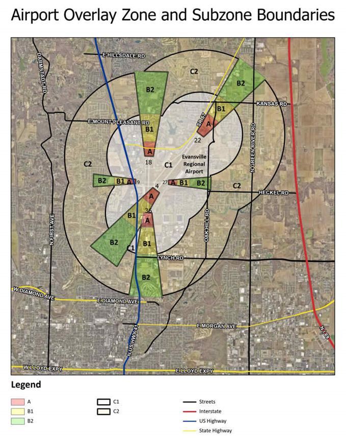
[Ord. G-2023-20 § 3, passed 11-15-23.]
18.118.060 Land use restrictions.
To minimize land use conflicts, the following restrictions shall apply in the zones and sub-zones listed below:
(A) Use Restrictions in Zone A.
(1) Above-ground structures are prohibited.
(2) All use groups and special uses are prohibited except for crop farming in Use Group 17(C).
(B) Use Restrictions in Other Zones and Sub-Zones.
(1) The Table – Prohibited Land Uses in this section lists uses and special uses that shall be prohibited in specific portions of the AIR-O. The table displays the uses by sub-zone, and by the following three types of problems they present for the airport:
(a) Uses that are incompatible when near the airport or that promote the assembly of people;
(b) Uses that present safety hazards including fire and explosion risks; and
(c) Uses that are known to be wildlife attractants.
(i) The presence of wildlife at or near an airport can result in safety hazards for airport operations (e.g., bird strikes) and potentially for surrounding properties, or result in damage to airport facilities (e.g., from burrowing, nesting, etc.).
(ii) Wildlife attractant uses include but are not limited to those listed in FAA Advisory Circular 150/5200-33C, Hazardous Wildlife Attractants On or Near Airports.
(iii) To protect public safety, wildlife attractant uses shall be regulated near the airport, except when the airport approves a mitigation plan submitted by the applicant that commits to proper mitigation through best management practices.
(2) Uses with above-ground structures that are potential safety hazards due to height, glare, heat plumes, any interference with air traffic communications, visual approach, or other characteristics are prohibited.
(3) Table – Prohibited Land Uses. (X = prohibited)
|
|
ZONES |
||
|---|---|---|---|
|
B1 |
B2 |
C1 |
|
|
ASSEMBLAGE OF PEOPLE |
|||
|
Major residential subdivisions |
X |
|
|
|
Use Groups 4, 5 except for 5(D), 6, 19(A) campground only, and 20 |
X |
|
|
|
Special Uses 3, 8, 25 campground only, 28, 34 and 46 |
X |
|
|
|
Use Groups 4 when zoned R-5 only, 5(A) zoned M-1 only, 5(B) and 5(C) |
|
X |
|
|
Special Use 3 except when zoned A and R-4 |
|
X |
|
|
Use Groups 6, 8(B) business school, commercial trade school, dance/theatrical school or studio only; 8(E) dance hall, meeting hall, or party house; theater only; 8(H) when zoned M-1 and M-2 only, 8(I) and 19(A) child care center only |
X |
X |
|
|
Special Uses 1, 2, 25 child care center only and 30 |
X |
X |
|
|
Special Uses 16 and 25 except for campgrounds, and child care centers |
X |
X |
X |
|
SAFETY HAZARDS |
|||
|
Use Group 8(F) |
X |
|
|
|
Use Groups 13(P), 16(A) explosives, fertilizer, gas only, 16(B) petroleum refining only and 16(C) |
X |
X |
X |
|
Special Uses 17 and 23 except for indoor firearms uses |
X |
X |
X |
|
WILDLIFE ATTRACTANTS |
|||
|
Use Group 17(B) specifically aquaculture (fisheries) only |
X |
X |
X |
|
Special Uses 9, 15, and 20 |
X |
X |
X |
(C) Conflicting Use Regulations. If a conflict occurs between the permitted and prohibited uses (including special uses) in the AIR zoning district versus those listed in this chapter, the more restrictive regulation shall apply. [Ord. G-2023-20 § 3, passed 11-15-23.]
18.118.070 Airspace obstruction/height limitation.
(A) General.
(1) To carry out the purposes of this chapter, the airport obstacle/height limitation regulations referenced in this section restrict the height of new structures and objects that may be hazardous to the operational safety of aircraft approaching and departing from the airport.
(2) These airport obstacle/height limitations are contained in FAR Part 77 of the FAA guidance and are applicable to the AIR-O land use compatibility sub-zones as applied to the airport.
(3) In the development review process, if an airport comment letter indicates that a proposed building or structure will exceed the Part 77 height limitations within the AIR-O zone (including the C2 Zone), the applicant shall provide documentation of FAA/Indiana Tall Structures Act permit approval prior to issuance of an improvement location permit by the Planning Department.
(B) Applicability of Height Restrictions.
(1) All applicable Federal and State height restrictions shall apply within the area of the AIR-O, as well as the height standards set forth in Table A, EMC 18.130.010.
(2) Conflicting Regulations. If a conflict between the height limitations of the underlying zoning district, IC 8-21-10, Regulation of Tall Structures, and Federal Aviation Regulations occurs, the more restrictive regulation shall apply.
(3) Height Variances and Exceptions.
(a) Height variances to the zoning standards are considered in public meeting by the Board of Zoning Appeals (BZA) and applications for height variances shall follow the procedures stated in Chapter 18.165 EMC, Variances.
(b) If a height exception is also needed from Part 77 and the Indiana regulation of tall structures, the applicant shall:
(i) Follow the proper FAA and INDOT Office of Aviation procedures;
(ii) As required in IC 36-7-4-918.5, submit to the Planning Department, prior to any BZA approval of such a height variance in the AIR-O, a copy of the permit for the proposed structure issued by INDOT, a copy of the determination of no hazard to air navigation issued by the FAA, and evidence that proper notice was provided to the airport pursuant to IC 8-21-10-3, Regulation of Tall Structures.
(C) Prohibition of Airspace Zone Obstructions. No structure shall be constructed, altered, or maintained in excess of the airspace obstruction/height limitations of the imaginary airspace surfaces described in FAR Part 77 of the FAA guidance and included in the definitions section of this title, except as otherwise provided in this chapter, and except as necessary and incidental to airport operations. [Ord. G-2023-20 § 3, passed 11-15-23.]
18.118.080 Lighting standards.
(A) General.
(1) All lighting for proposed site developments shall be prohibited from projecting upward or horizontally; shall be mounted on a pole, structure, or building; and shall utilize full-cutoff luminaires.
(2) All signs shall be internally illuminated and shall not adversely impact aircraft safety or airfield operations as determined by the airport.
(3) With the exception of lighting for airport operations, no lighting (including any associated with signs) in the AIR-O shall spin, oscillate, or blink.
(B) Hazard Marking and Lighting. The applicant must follow the appropriate procedures required by the FAA to obtain a letter of determination regarding hazard markings and lighting. The airport may inspect the property, from time to time, to ensure compliance with the letter of determination. [Ord. G-2023-20 § 3, passed 11-15-23.]
18.118.090 Performance standards.
Development proposals that are anticipated to create any of the following conditions are prohibited:
(A) Impacts to visibility endangering aircraft operations by:
(1) The emission of air pollutants, such as smoke, dust, and noxious fumes, that could interfere with visibility; or
(2) The creation of glare;
(B) Impacts to airport communications due to electrical interference equipment; or
(C) Any other condition that could compromise aircraft safety. [Ord. G-2023-20 § 3, passed 11-15-23.]
18.118.100 Noise standards.
(A) Applicability.
(1) This section applies to parcels within the following four established noise sensitive areas around the airport as shown on the most recent version of the noise exposure contour map:
(a) DNL 75 dBA noise impact area.
(b) DNL 70 dBA noise impact area.
(c) DNL 65 dBA noise impact area.
(d) DNL 60 dBA noise impact area.
(2) Noise sensitive areas are based on projected yearly averaged, 24-hour day/night average noise level (DNL) impact projections arising from aircraft flight operations. The boundaries of these areas are shown on the most recent noise exposure contour map, which can be obtained from the airport.
(3) The Table – Noise and Land Use Compatibility in this section indicates whether various land uses are allowed within the four noise impact areas at the airport.
(4) The boundaries of the noise impact area may change due to future updates of the noise exposure contour map. Upon approval of any new updated map, the airport shall provide a copy of the map to the Planning Department for documentation of the new noise impact area boundaries.
(B) Noise Sensitive Area Sound Level Reduction Requirements. Buildings that exist and uses that are in operation at the time of adoption of the ordinance codified in this chapter do not require conformance to these provisions, except as specifically provided below.
(C) Table – Noise and Land Use Compatibility.
|
Land Use |
Yearly day-night average sound level (DNL) in decibels |
|||
|---|---|---|---|---|
|
|
60 |
65 |
70 |
75 |
|
RESIDENTIAL |
||||
|
Use Groups 1, 3, 4, 6, 8(H) and 20 |
Y |
N1 |
N1 |
N |
|
Special Uses 3, 8, 31 and 46 |
Y |
N |
N |
N |
|
PUBLIC USE/INSTITUTIONAL |
||||
|
Use Groups 8(I), 15(E), 18(C) and 19(D) |
Y |
N2 |
N2 |
N |
|
Special Uses 1, 2, 5, 14, 16 and 30 |
Y |
Y2 |
Y2 |
N |
|
COMMERCIAL |
||||
|
Use Group 5, 7, 8(A), (B), (C), (D), (F) and (G), 9 (excluding 9(D), 9(E), 10 (excluding 10(C)), 11 (excluding 11(C)), 13(C) and 21 |
Y |
Y |
Y2 |
N |
|
RECREATIONAL/OPEN SPACE |
||||
|
Use Groups 8(E) and 9(D), 11(C), 15(F), 18(E), 18(G) and 19(A) |
Y |
Y |
N |
N |
|
Special Uses 4, 7, 24 and 25 |
Y |
Y |
Y |
N |
|
TRANSPORTATION |
||||
|
Special Use 11 |
Y |
Y |
Y2 |
N |
TABLE KEY and FOOTNOTES: Y = Allowed N = Not Compatible
1. Where the community determines that residential or school uses are allowed, measures to achieve outdoor to indoor noise level reduction (NLR) of at least 25 dB and 30 dB should be incorporated into building codes to be considered in individual approvals. Normal residential construction can be expected to provide a NLR of 20 dB; thus, the reduction requirements are often stated as 5, 10 or 15 dB over standard construction and normally assume mechanical ventilation and closed windows year round. However, NLR design will not eliminate outdoor noise.
2. Measures to achieve NLR 25 dB must be incorporated into the design and construction of portions of these buildings where the public is received, office areas, noise sensitive areas or where the normal noise level is low.
Source: Derived from a similar chart in the FAA Part 150 Airport Noise Compatibility Planning document.
[Ord. G-2023-20 § 3, passed 11-15-23.]
18.118.110 Prohibitions.
The following structures and uses are prohibited in the AIR-O:
(A) New structures that would exceed the height limits set forth in the applicable zoning district, unless the structure is approved for a variance by the Board of Zoning Appeals as discussed in EMC 18.118.070(B)(3).
(B) Uses listed as “N,” meaning “not compatible,” in EMC 18.118.100(C), Table – Noise and Land Use Compatibility, are not allowed unless any applicable noise level reduction requirements are met.
(C) Any structure or use which is determined by the FAA to create a safety hazard for aircraft operations, through either an FAA 7460-1 airspace analysis or another FAA review process. [Ord. G-2023-20 § 3, passed 11-15-23.]