


Chapter 17.04
SUBDIVISION STANDARDS
Sections:
17.04.010 Street Networks and Street Design.
17.04.020 Open and Civic Space Systems.
17.04.040 Required Improvements.
17.04.050 Community Facilities and Fees.
17.04.010 Street Networks and Street Design
A. Intent. The intent of this section is to:
1. Plan and coordinate street networks to ensure the proper arrangement of blocks and lots for long-range development.
2. Emphasize street design as a key determinant of Gardner’s image and identity.
3. Provide for efficient and safe movement of all potential users of the streets, including pedestrians, bicycles, automobiles, and trucks or transit.
4. Use streetscape design to call attention to differing contexts within the City and better support development patterns and uses abutting the streets.
5. Plan street networks to increase connectivity, improve options for access in the community, and allow greater variety of street designs on different street segments.
6. Balance street designs so the interests of a single mode of transportation do not compromise other modes.
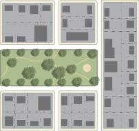
B. Street Network. Arterial, collector and local streets shall generally be laid out according to the policies of the Comprehensive Plan, Transportation Master Plan, Park System Master Plan and other plans or maps for major streets. In the absence of more specific guidance in these plans, the following standards shall apply to street networks:
1. Blocks and Connectivity. Streets shall be laid out to provide a network of blocks and streets based on the planning context and development pattern as identified in Table 4-1:
|
Table 4-1: Block Sizes and Connectivity |
|||
|---|---|---|---|
|
Planning Context |
Block Length |
Block Area |
Cul-de-sac Limits |
|
Walkable/Compact Downtown, core areas of commercial centers, and abutting blocks adjacent to walkable places. |
250' min. 500' max. |
2.5 – 5 acres |
Prohibited |
|
General Traditional neighborhoods, near downtown areas, and areas supporting commercial corridors. |
350' min. 800' max. |
4 to 8 acres |
250' max. |
|
Suburban Areas more removed from walkable centers, commercial corridors or large scale projects arranged around a campus plan. |
500' min. 1,000' max. |
5 to 8 acres |
500' max. |
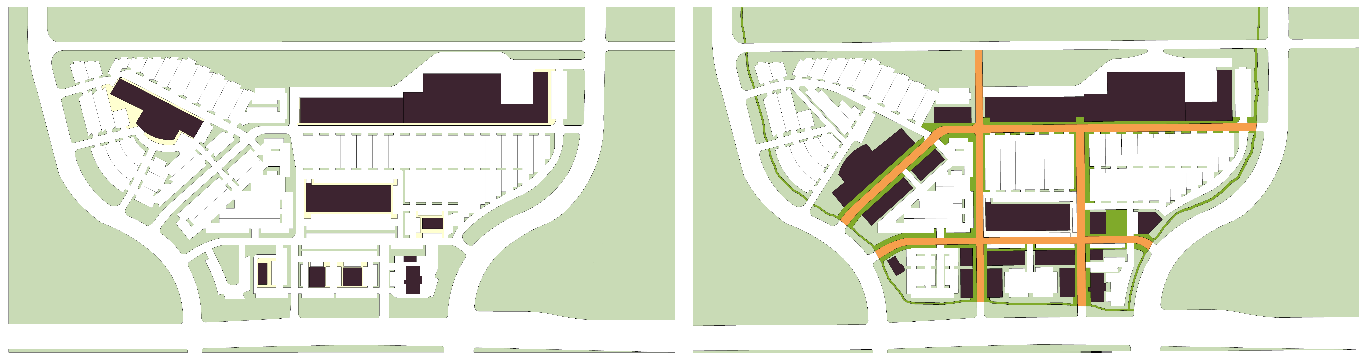
Figure 4-1 Street Network Design
Exceptions for larger blocks and oversized parcels should mimic the connectivity, street networks, and streetscape designs required by this Code with internal street networks.
2. External Connections. Street network plans shall provide for the continuation of streets in adjacent subdivisions and to future growth areas at intervals that meet these standards and shall be constructed to the subdivision boundary.
3. Offsets. Slight jogs in continuous streets at points of intersection with other streets shall not be permitted unless due to topography. Where offsets cannot be avoided, a minimum distance of 150 feet shall be established between centerlines of the intersecting streets.
4. Exceptions. The following are exceptions to the block and connectivity standards:
a. Natural Features and Civic Spaces. Blocks or parcels abutting or containing important natural features, topographical constraints or otherwise creating parts of the Civic Space System, may be larger provided the proposed street layout preserves these features and integrates them into the overall structure of the community.
b. Regional Transportation Routes. Blocks or parcels abutting intervening regional transportation routes such as highways or rail rights-of-way may be larger; provided, that street layouts and development patterns achieve local connectivity in all other ways possible.
c. Rural Parcels. Tracts divided into larger or rural lots of at least five acres may exceed block limits, provided development is arranged to allow future streets in compliance with these regulations, and a logical pattern of resubdivision can occur with minimal disruption of buildings, utilities, and other structures.
d. Oversized Parcels. Where oversized parcels are platted for special land uses or development projects that involve large-scale buildings and patterns, such as campuses or large-scale employment areas, platted blocks may be larger, provided internal access streets mimic the block structure and urban design amenity of these standards, and create logical extensions and connectivity to the public streetscapes.
5. Dead End Streets. In any case where streets are not required to connect by these standards, dead end streets shall be limited as specified in Table 4-1. Turn-around shall be required with an outside right-of-way line radius of at least 50 feet. Alternative designs such as loops or closes are preferred over dead ends and cul-de-sacs.
6. Walkways and Passages. In any case where exceptions for larger blocks apply, or any other area where substantial pedestrian traffic may occur, such as adjacent to schools, the Planning Commission or Governing Body may require pedestrian walkways through blocks or at any dead end streets. Such walkways shall be dedicated to the public in the same manner as streets and shall meet the Trail/Greenway design standards in GMC 17.04.020.
C. Street Design. Streets shall be designed to reinforce the character of the area and the anticipated development patterns, land uses and designs of projects fronting the street.
1. Street Design Types. Each functional classification may use the following Street Design Types so that urban design features and streetscape design better support the development context and character of the area. Table 4-2 identifies which design types are most appropriate for different contexts and different functional classes of streets.
|
Table 4-2: Street Design Types and Functional Classification |
|||
|---|---|---|---|
|
Street Type |
Arterial (A) |
Collector (C) |
Local (L) |
|
Standard A basic street type appropriate generally where no particular development characteristics or urban design context warrant application of other street types. |
■ |
☐ |
☐ |
|
Activity A pedestrian-oriented street type appropriate for all areas where walkability is a goal. It is characterized by narrow lanes, slow speeds, on-street parking, and large, well-designed pedestrian amenity zones that support businesses and economic activity along these streets. |
☐ |
■ |
■ |
|
Neighborhood A community-oriented street type appropriate where a higher level of neighborhood design amenity and neighborhood walkability is desired. It is characterized by large street trees, sidewalks, slow speeds, and occasional on-street parking. |
■ |
■ |
■ |
|
Green A natural-oriented street type appropriate where streets cross or align with natural features, particularly to emphasize the parks and environmental themes in the plan. It is characterized by slow to moderate speeds, informal and natural landscape edges, and the incorporation of the City trails system. |
☐ |
■ |
■ |
|
■ Preferred Type ☐ Limited Type, based on development pattern, street network plan and surrounding context and natural characteristics |
|||
2. Complete Streets Policy Guide. The Complete Streets Design Policy and Standards in Appendix B provides a framework for assembling cross sections for each specific street type. The standards and guidelines in Appendix B shall be used to create specific cross sections for a specific context, or to adjust the typical street cross sections provided in this section.
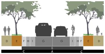
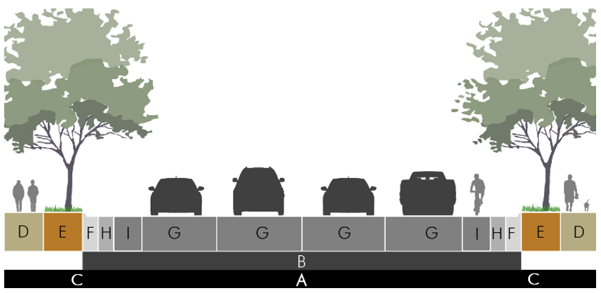
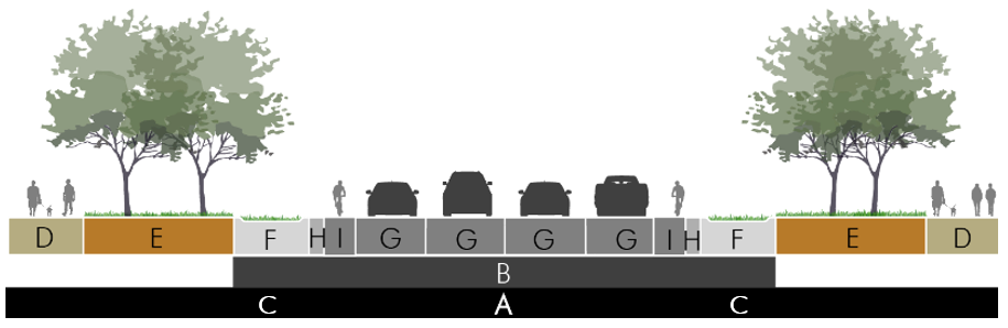
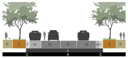
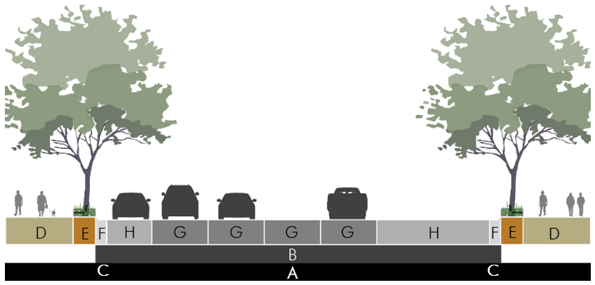
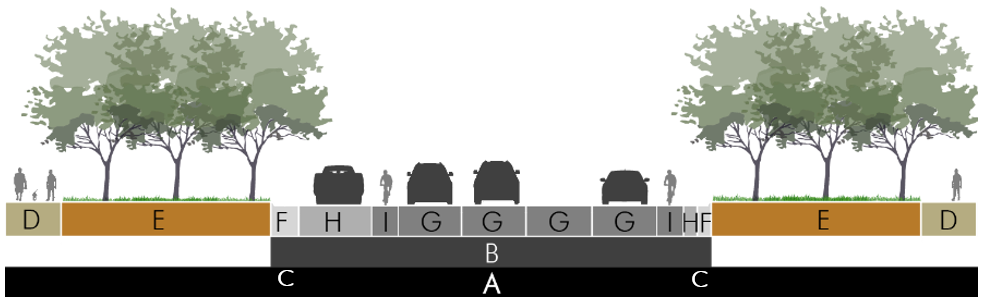
3. Typical Cross Sections. The following are typical cross sections for each functional classification and street design type, applying the complete streets design policy and standards in Appendix B. They are a starting point for all street designs, and the City Engineer, Director, or Planning Commission may require modifications to these typical cross sections to account for the specific context and better meet the intent of this section.
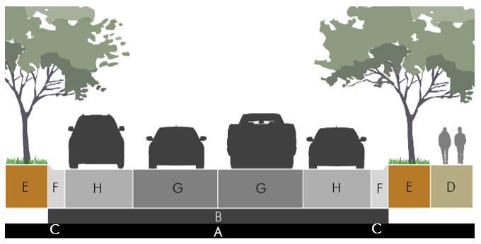
|
Width |
||
|
A |
Right-of-Way Width |
50' (min) |
|
B |
Pavement Width (back of curb) |
28' – 36' |
|
Streetscape |
||
|
C |
Utility Placement – See GMC 17.04.040(F) |
|
|
D |
Sidewalk |
5' one side |
|
E |
Planting Area/Amenity |
5' |
|
F |
Drainage/Street Edge |
1' – 2' curb/gutter |
|
Street |
||
|
G |
Travel Lane |
10' – 12' |
|
F/H |
Parking Area/Shoulder |
1' – 2' shoulder OR 8' parallel |
|
General |
||
|
|
Walkway Type |
Sidewalk/Detached |
|
|
Planting Type |
Tree lawn; easement alt. |
|
|
Tree Spacing |
40' – 60' on center |
|
|
Bicycle Facility |
None – within traffic flow |
|
|
Target Speed |
25 – 35 mph |
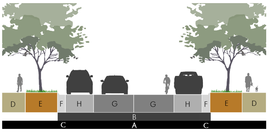
|
Width |
||
|
A |
Right-of-Way Width |
50' (min) |
|
B |
Pavement Width |
18' – 20' |
|
Streetscape |
||
|
C |
Utility Placement – See GMC 17.04.040(F) |
|
|
D |
Sidewalk |
10' trail (optional, one side) |
|
E/F |
Planting Area/Amenity |
15' (min) |
|
F |
Drainage/Street Edge |
6' swale (min) |
|
Street |
||
|
G |
Travel Lane |
9' – 10' |
|
H |
Parking Area/Shoulder |
2' shoulder |
|
General |
||
|
|
Walkway Type |
Multi-use trail |
|
|
Planting Type |
Natural area |
|
|
Tree Spacing |
Dense landscape |
|
|
Bicycle Facility |
None – within traffic flow |
|
|
Target Speed |
< 25 mph |
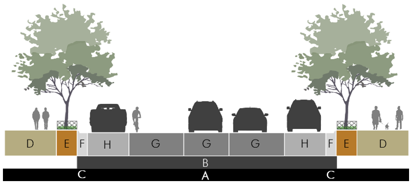
|
Width |
||
|
A |
Right-of-Way Width |
50' (min) |
|
B |
Pavement Width (back of curb) |
25' – 28' |
|
Streetscape |
||
|
C |
Utility Placement – See GMC 17.04.040(F) |
|
|
D |
Sidewalk |
5' (min) |
|
E |
Planting Area/Amenity |
6' (min) |
|
F |
Drainage/Street Edge |
1' – 2' curb/gutter |
|
Street |
||
|
G |
Travel Lane |
9' two-way; OR 14' yield flow |
|
F/H |
Parking Area/Shoulder |
6' limited parking |
|
General |
||
|
|
Walkway Type |
Sidewalk/Detached |
|
|
Planting Type |
Tree lawn |
|
|
Tree Spacing |
25' – 40' on center |
|
|
Bicycle Facility |
None – within traffic flow |
|
|
Target Speed |
< 20 mph |

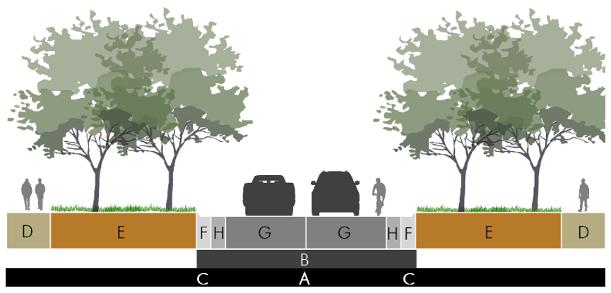
|
Width |
||
|
A |
Right-of-Way Width |
50' (min) |
|
B |
Pavement Width (back of curb) |
34' (parallel parking) 60' (angled parking) |
|
Streetscape |
||
|
C |
Utility Placement – See GMC 17.04.040(F) |
|
|
D/E |
Sidewalk |
8' (min) |
|
E |
Planting Area/Amenity |
4' – 6' tree wells |
|
F |
Drainage/Street Edge |
1' – 2' curb/gutter |
|
Street |
||
|
G |
Travel Lane |
10' – 11' |
|
F/H |
Parking Area/Shoulder |
7' parallel 19' angled (60°) |
|
General |
||
|
|
Walkway Type |
Sidewalk/Attached |
|
|
Planting Type |
Tree wells |
|
|
Tree Spacing |
25' on center |
|
|
Bicycle Facility |
None – within traffic flow |
|
|
Target Speed |
< 20 mph |
|
Width |
||
|
A |
Right-of-Way Width |
60' (min) two lane 80' (min) four lane |
|
B |
Pavement Width (back of curb) |
28' – 32' two lane 50' – 56' four lane |
|
Streetscape |
||
|
C |
Utility Placement – See GMC 17.04.040(F) |
|
|
D |
Sidewalk |
5' (min) |
|
E |
Planting Area/Amenity |
5' (min) |
|
F |
Drainage/Street Edge |
1' – 2' curb/gutter |
|
Street |
||
|
G |
Travel Lane |
10' – 11' two to four lane |
|
F/H |
Parking Area/Shoulder |
1' – 2' shoulder |
|
General |
||
|
|
Walkway Type |
Sidewalk/Detached |
|
|
Planting Type |
Tree wells |
|
|
Tree Spacing |
40' – 60' on center |
|
I |
Bicycle Facility |
14' outside shared lane; OR |
|
|
Target Speed |
35 mph |

|
Width |
||
|
A |
Right-of-Way Width |
60' (min) two lane 70' (min) three lane |
|
B |
Pavement Width (back of curb) |
24' – 32' two lane 34' – 42' three lane |
|
Streetscape |
||
|
C |
Utility Placement – See GMC 17.04.040(F) |
|
|
D |
Sidewalk |
10' |
|
E/F |
Planting Area/Amenity |
15' (min) |
|
F |
Drainage/Street Edge |
8' swale (min) |
|
Street |
||
|
G |
Travel Lane |
10' – 11' two to three lane |
|
H |
Parking Area/Shoulder |
2' shoulder |
|
General |
||
|
|
Walkway Type |
Multi-use path |
|
|
Planting Type |
Natural area |
|
|
Tree Spacing |
Irregular/Dense |
|
G |
Bicycle Facility |
14' outside shared lane OR 6' dedicated lane |
|
|
Target Speed |
30 – 35 mph |
|
Width |
||
|
A |
Right-of-Way Width |
60' (min) two lane 70' (min) three lane |
|
B |
Pavement Width (back of curb) |
24' – 34' two lane 34' – 40' three lane |
|
Streetscape |
||
|
C |
Utility Placement – See GMC 17.04.040(F) |
|
|
D |
Sidewalk |
6' (min) |
|
E |
Planting Area/Amenity |
8' (min) |
|
F |
Drainage/Street Edge |
1' – 2' curb/gutter |
|
Street |
||
|
G |
Travel Lane |
10' – 11' two to three lane |
|
F/H |
Parking Area/Shoulder |
7' parallel – both sides; OR 6' parallel – one side three lane |
|
General |
||
|
|
Walkway Type |
Sidewalk/Detached |
|
|
Planting Type |
Tree lawn |
|
|
Tree Spacing |
25' – 40' on center |
|
G |
Bicycle Facility |
14' outside shared lane |
|
|
Target Speed |
< 30 mph |
|
Width |
||
|
A |
Right-of-Way Width |
60' – 96' two lane 70' – 94' three lane 80' – 104' four lane |
|
B |
Pavement Width (back of curb) |
36' – 62' two lane 46' – 70' three lane 56' – 80' four lane |
|
Streetscape |
||
|
C |
Utility Placement – See GMC 17.04.040(F) |
|
|
D/E |
Sidewalk |
10' (min) |
|
E |
Planting Area/Amenity |
4' – 6' tree well |
|
F |
Drainage/Street Edge |
1' – 2' curb/gutter |
|
Street |
||
|
G |
Travel Lane |
10' – 11' two to four lane |
|
F/H |
Parking Area/Shoulder |
8' parallel 20' angled (60°) |
|
General |
||
|
|
Walkway Type |
Sidewalk/Attached |
|
|
Planting Type |
Tree well |
|
|
Tree Spacing |
25' – 40' on center |
|
|
Bicycle Facility |
None – within traffic flow |
|
|
Target Speed |
< 20 mph |
|
Width |
||
|
A |
Right-of-Way Width |
80' – 90' two lane 96' – 100' four lane |
|
B |
Pavement Width (back of curb) |
24' – 36' two lane (14' – 16' each if center median) 50' – 54' four lane (26' – 28' each if center median) |
|
Streetscape |
||
|
C |
Utility Placement – See GMC 17.04.040(F) |
|
|
D |
Sidewalk |
6' (min) |
|
E |
Planting Area/Amenity |
20' (min) |
|
F |
Drainage/Street Edge |
1' – 2' curb/gutter |
|
Street |
||
|
G |
Travel Lane |
10' – 11' two to four lane |
|
F/H |
Parking Area/Shoulder |
1' – 2' shoulder |
|
General |
||
|
|
Walkway Type |
Sidewalk/Detached |
|
|
Planting Type |
Tree lawn OR Tree lawn + median |
|
|
Tree Spacing |
25' – 40' on center OR 40' – 60' if double row in tree lawn or tree lawn + median |
|
G/H |
Bicycle Facility |
14' outside shared lane OR 6' dedicated lane |
|
|
Target Speed |
35 mph |
|
Width |
||
|
A |
Right-of-Way Width |
120' |
|
B |
Pavement Width (back of curb) |
46' – 60' four lane 60' – 70' five lane |
|
Streetscape |
||
|
C |
Utility Placement– See GMC 17.04.040(F) |
|
|
D |
Sidewalk |
5' (min) |
|
E |
Planting Area/Amenity |
5' (min) + 12' center median |
|
F |
Drainage/Street Edge |
1' – 2' curb/gutter |
|
Street |
||
|
G |
Travel Lane |
10' – 12' four to five lane |
|
F/H |
Parking Area/Shoulder |
1' – 2' shoulder |
|
General |
||
|
|
Walkway Type |
Sidewalk/Detached |
|
|
Planting Type |
Tree lawn; Easement alt. + median |
|
|
Tree Spacing |
40' – 60' on center |
|
I |
Bicycle Facility |
6' dedicated lane OR Off-street trail |
|
|
Target Speed |
35 – 45 mph |
|
Width |
||
|
A |
Right-of-Way Width |
90' three lane 100' four lane |
|
B |
Pavement Width (back of curb) |
28' – 36' two lane 44' – 52' four lane |
|
Streetscape |
||
|
C |
Utility Placement – See GMC 17.04.040(F) |
|
|
D |
Sidewalk |
10' |
|
E/F |
Planting Area/Amenity |
20' (min) |
|
F |
Drainage/Street Edge |
10' swale (min) |
|
Street |
||
|
G |
Travel Lane |
10' – 12' two to four lane |
|
H |
Parking Area/Shoulder |
2' shoulder |
|
General |
||
|
|
Walkway Type |
Multi-use path |
|
|
Planting Type |
Natural area |
|
|
Tree Spacing |
Irregular/Dense |
|
I |
Bicycle Facility |
Off-street trail OR 6' dedicated lane |
|
|
Target Speed |
35 – 45 mph |
|
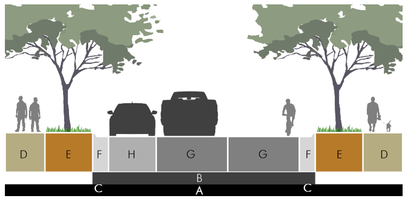
Width |
||
|
A |
Right-of-Way Width |
70' (min) three lane 80' (min) four lane |
|
B |
Pavement Width (back of curb) |
34' – 40' three lane 44' – 50' four lane |
|
Streetscape |
||
|
C |
Utility Placement – See GMC 17.04.040(F) |
|
|
D |
Sidewalk |
6' (min) |
|
E |
Planting Area/Amenity |
8' (min) |
|
F |
Drainage/Street Edge |
1' – 2' curb/gutter |
|
Street |
||
|
G |
Travel Lane |
10' – 11' three to four lane |
|
F/H |
Parking Area/Shoulder |
7' parallel; OR 1' – 2' shoulder |
|
General |
||
|
|
Walkway Type |
Sidewalk/Detached |
|
|
Planting Type |
Tree lawn |
|
|
Tree Spacing |
25' – 40' on center |
|
G |
Bicycle Facility |
14' shared lane |
|
|
Target Speed |
< 30 – 35 mph |
|
Width |
||
|
A |
Right-of-Way Width |
80' – 90' three lane 90' – 100' four lane |
|
B |
Pavement Width (back of curb) |
48' – 62' three lane 56' – 80' four lane |
|
Streetscape |
||
|
C |
Utility Placement – See GMC 17.04.040(F) |
|
|
D/E |
Sidewalk |
12' (min) |
|
E |
Planting Area/Amenity |
4' tree well (min) |
|
F |
Drainage/Street Edge |
1' – 2' curb/gutter |
|
Street |
||
|
G |
Travel Lane |
10' three to four lane |
|
H |
Parking Area/Shoulder |
8' parallel 20' angled (60°) |
|
General |
||
|
|
Walkway Type |
Sidewalk/Attached |
|
|
Planting Type |
Tree well |
|
|
Tree Spacing |
25' on center |
|
|
Bicycle Facility |
None – within traffic flow |
|
|
Target Speed |
< 20 mph |
|
Width |
||
|
A |
Right-of-Way Width |
120' – 130' four lane 140' – 150' six lane |
|
B |
Pavement Width (back of curb) |
50' – 54' four lane (26' – 28' each if center median) 74' – 78' six lane (38' – 40' each if center median) |
|
Streetscape |
||
|
C |
Utility Placement – See GMC 17.04.040(F) |
|
|
D |
Sidewalk |
8' (min) |
|
E |
Planting Area/Amenity |
30' (min) |
|
F |
Drainage/Street Edge |
1' – 2' curb/gutter |
|
Street |
||
|
G |
Travel Lane |
10' – 11' four to six lane |
|
F/H |
Parking Area/Shoulder |
1' – 2' shoulder |
|
General |
||
|
|
Walkway Type |
Sidewalk/Detached |
|
|
Planting Type |
Tree lawn OR Tree lawn + median |
|
|
Tree Spacing |
25' – 40' on center OR 40' – 60' if double row in tree lawn or tree lawn + median |
|
G/I |
Bicycle Facility |
14' shared lane OR 6' dedicated lane |
|
|
Target Speed |
35 mph |
D. Intersection Design.
1. Corner Curb Radii. Corner curb radii shall be the minimum amount necessary to balance the competing interest of vehicle turning movements and the distance and safety of pedestrians crossing the street, based on the appropriate context. Table 4-3 establishes the base requirements. In areas where large vehicles will make frequent turning movements, the Commission may require greater corner curb radii. In areas where slower speeds are desired or walkability is desired the Commission may require tighter corner curb radii.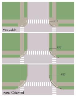
Figure 4-2 Corner Curb Radii
Intersections with smaller corner curb radii reduce crossing distances and slow traffic to improve safety for pedestrians.
|
Table 4-3: Corner Curb Radius |
|
|---|---|
|
Intersection Type |
Curb Radius |
|
Local/Local |
5' to 15' |
|
Local/Collector |
10' to 20' |
|
Local/Arterial |
15' to 20' |
|
Collector/Collector |
10' to 20' |
|
Collector/Arterial |
20' to 30' |
|
Arterial/Arterial |
25' to 30' |
2. Sight Distances. Proper lines of sight shall be maintained at all intersections. The proper line of sight shall be an unobstructed view from the stopping point on the approaching street to all points three feet above the roadway along the centerline of the intersecting street. The distance of the unobstructed view shall be based upon the design speed of the intersecting street, specified in Table 4-4.
|
Table 4-4: Clear Sight Distance |
|
|---|---|
|
Design Speed |
Intersection Sight Distance (measured along centerline of intersecting street) |
|
15 mph |
105' |
|
20 mph |
125' |
|
25 mph |
150' |
|
30 mph |
200' |
|
35 mph |
225' – 250' |
|
40 mph |
275' – 325' |
|
45 mph |
325' – 400' |
Source: American Association of State Highway and Transportation Officials, A Policy on Geometric Design of Highways and Streets.
a. No building or other type of visual obstruction shall be placed or maintained within the triangle created by the centerline of the street intersection, the stopping point on the approaching street, and the sight distance specified in Table 4-4 to the centerline of the intersecting street.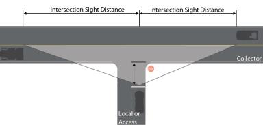
Figure 4-3 Sight Distances
Sight distances for intersections and road access shall be measured from a control point and based on the speeds of oncoming traffic.
b. Street trees, light poles or other limited obstructions are allowed within the sight triangle provided that they do not have any foliage, limbs, or other obstructions between two and eight feet, and are no closer than 30 feet to the intersecting right-of-way line.
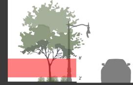
Figure 4-4 Limited Obstructions
Limited obstructions may be permitted in contexts where they do not impede sight lines and are appropriate to the overall urban design characteristics of the public realm.
c. Fully controlled intersections, where signalization establishes and prioritizes safe turning movements, may deviate from the above sight triangle standards if site conditions warrant and based upon a recommendation of the City Engineer.
3. Crosswalks. Intersections of sidewalks with public streets shall have crossings meeting the following standards:
a. Curb ramps meeting ADA accessibility standards shall provide a direct, nondiverted approach from the sidewalk along the block, into the crosswalk area.
b. Crosswalks on collector streets or higher classification shall be considered for enhanced crossings, including bulb outs, refuge islands or other traffic calming measures that are appropriate to the context of the intersection.
c. Where blocks exceed more than 800 feet between intersections, or at other locations of high pedestrian activity, midblock crossings shall be considered. Midblock crossing designs and locations are subject to approval of the Director and City Engineer. (Ord. 2518 § 2 (LDC § 4.01))
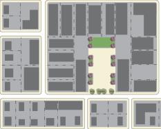
17.04.020 Open and Civic Space Systems
A. Intent. The intent of this section is to:
1. Recognize open space as an important and enduring element of civic design and Gardner’s image and identity.
2. Plan and integrate an open and civic space system into the structure of streets, blocks and lots as a coordinated part of the public realm.
3. Value the design, function, and appropriate application of different types of open space, rather than solely the quantity of space.
4. Develop a greater perceived impact from open space by coordinating the design and location of open spaces across multiple development projects.
5. Consider the context and multiple functions that open spaces can serve to support development, including ecological, recreation, aesthetic and urban design functions.
6. Create focal points for the community, neighborhood, district, or development site to which development and site plans should respond.
7. Integrate natural systems into the design of common or public open spaces.
B. Applicability.
1. Generally. These standards apply to all divisions of land involving more than five acres. All platted lots shall have access to one or more of the open and civic space types in this section, within the specified service area. The open space requirement is in addition to any landscape, setback, buffer or frontage type requirement in this Code; however, effective site design can allow areas to meet multiple standards.
2. Exceptions. Any lot platted within the applicable service area for any existing open and civic space types below does not require any new open spaces, provided:
a. It is public; or
b. It is private or common and the property owner has a right to access this property through easements, covenants or other formal documentation of the entity with ownership and control of the space.
C. Open Space Types. Open and civic space systems shall be laid out according to the policies of the Comprehensive Plan, and in particular sections relating to the Parks and Recreation Plan, Environmental Features Plan, Community Character Plan, and the Park System Master Plan. Open spaces shall be designed to reinforce the character of the area and anticipated development patterns, uses and project designs. Table 4-5 indicates the types of open spaces that are eligible for each particular area based on context. Standards and specifications for each open space type are provided in subsection (F) of this section.
|
Table 4-5: Open and Civic Space Types and Context |
||||||
|---|---|---|---|---|---|---|
|
|
|
|
|
|
|
|
|
Planning Context |
Natural Area |
Park |
Trail/Greenway |
Green |
Square |
Plaza/Courtyard |
|
Walkable/Compact Downtown, core areas of commercial centers, and abutting blocks adjacent to walkable places. |
☐ |
☐ |
☐ |
■ |
■ |
■ |
|
General Traditional neighborhoods, near downtown areas, and areas supporting commercial corridors. |
☐ |
■ |
☐ |
■ |
■ |
■ |
|
Suburban Areas more removed from walkable centers, commercial corridors or large scale projects arranged around a campus plan. |
☐ |
■ |
■ |
■ |
☐ |
☐ |
|
■ Preferred Type ☐ Limited Type, based on opportunities corresponding with the bike and pedestrian plan trail locations or environmental features plan. |
||||||
D. Required Open Space. The amount of space required shall be based on the base zoning district(s) proposed or existing for the project and based on Table 4-6.
|
Table 4-6: Required Open Space |
|
|---|---|
|
A, RE |
N/A |
|
R-1, R-2 |
10% |
|
R-3, R-4, R-5, RM-P |
15% |
|
C-O, CO-A, C-1 |
8% |
|
C-2, C-3 |
12% |
|
M-1, M-2, REC |
N/A |
The amounts required in Table 4-6 may be reduced:
1. Based on a plan through the planned development process that meets or exceeds the intent of this section;
2. To the point where any lesser percentage of open space will clearly meet both the service area and level of service targets identified in subsection (F) of this section; or
3. For any application that dedicates open space to the public in a type, location and design standard that is acceptable to meet general public needs.
E. Location Criteria. The following location criteria shall be used in determining the most appropriate locations and characteristics of land to be designated as required open and civic space systems:
1. Priority should be given to areas that provide the most visible impact, and to locations that provide relationships to open and civic space systems on adjacent property and future development sites.
a. Formal open spaces (Greens, Squares, or Plazas) should be located at prominent focal points within a subdivision or development site, and included in or designed as an effective extension of the public rights-of-way, or other common areas.
b. Natural open space (Natural Areas, Trails/Greenways, or Parks) should be located along prominent ridges, valleys and view corridors or areas where other natural features such as significant vegetation or water features exist.
2. Open space shall be located in areas that maximize its functional characteristics.
a. Formal open space shall be centered in areas that will have the greatest population density, activity or development intensity in order to provide the greatest pedestrian accessibility.
b. Natural open space shall be located in areas where the ecological, aesthetic, and recreational impact will be the greatest.
F. Design Standards. Open Space Systems shall be designed according to the specific type, and the standards below for each different type.
|
Natural Area |
|
|
The size, location, and design of a Natural Area shall be dependent on the planning context, the presence of natural amenities and ecological functions worthy of protection, and the ability of the designated area to provide significant continuity with nearby natural features. However, in general these areas should provide the opportunity of at least 5 acres of contiguous preserved area; and ideally up to 40 or more acres. |
|
|
|
|
|
Service Area N/A |
|
|
|
|
|
Level of Service 12 acres per 1,000 people |
|
|
|
|
|
Design Elements Natural Areas include any area of existing or restored open lands such as riparian corridors, flood hazard areas, unique geological formations, important habitats, significant plant types or substantial groupings of important plant types, wetlands, etc. The goal is to protect the edges of these areas to maximize intact areas that provide valuable ecosystem services for the community, support preservation goals or enhance the aesthetics and amenities of the area. |
|
|
|
|
|
Park |
|
|
Size 3 – 10 acres, 5+ acres ideal (Neighborhood) 5 – 50 acres; 10+ acres ideal (Community) 40 acres min. for passive uses or sportsplex uses |
|
|
|
|
|
Service Area 1/4 – 1/2 mile (Neighborhood) 1/2 mile – 3 miles depending on size (Community) |
|
|
|
|
|
Level of Service 12 acres per 1,000 people |
|
|
|
|
|
Note: Public dedication and acceptance of Parks is dependent on other parameters of the Parks System Master Plan. |
|
|
|
|
|
Design Elements Parks shall generally be at least 300' wide in all directions, except that linear natural features (Greenway) may be designed as a Park with portions as narrow as 40', provided it has significant continuity between other open space features and preserves significant aesthetic and ecological functions. One large/medium tree for every 40' of street frontage to relate the Park to the public realm, plus other landscape to support the overall Park design. Between 15% and 50% of the area should be allocated to structured recreation such as ball fields, playgrounds or sport courts. The remainder of the area should be allocated to ground cover, treed areas, gardens, lawns or other landscape amenities. |
|
|
Trail/Greenway |
|
|
Size 20' min. width; 30'+ ideal, but dependent on topography and natural features. Trails/Greenways shall be located to provide continuity through the area, with existing or likely connections to other supporting facilities and the ability to link important destinations for those on foot or on bicycle, such as parks, schools and community centers or other civic destinations. |
|
|
|
|
|
Service Area 1/8 mile, or 1/4 mile from access point |
|
|
|
|
|
Level of Service 12 acres per 1,000 people |
|
|
|
|
|
Note: Public dedication and acceptance of a Trail/Greenway is dependent on other parameters of the Parks System Master Plan. |
|
|
|
|
|
Design Elements Trails/Greenways should include a paved or otherwise dust free stabilized surface at least 8' min. width; 10' min. if shared bike/pedestrian trail. The landscape area on each side of the trail should be at least 6', and wider in places to incorporate natural features or significant vegetation. One large/medium tree for every 40' of trail length; and 1 small tree for every 25' of trail length. Trails/Greenways located along rights-of-way may be designed in conjunction with the overall cross section design of the right-of-way to create the optimal multi-modal design for the street and trail. See Parks System Master Plan for specific details. |
|
|
|
|
|
Green |
|
|
Size 1/2 to 3 acres |
|
|
|
|
|
Service Area 2,000 feet |
|
|
|
|
|
Level of Service 5% to 10% of non-right-of-way land area OR 2 acres per 1,000 people |
|
|
Design Elements Greens shall be at least 150' wide in all directions, and should have an enclosure ratio (width of space to height of buildings) for buildings on the Green between 4:1 and 2:1. Greens should have a public street along at least 2 sides with direct pedestrian access to the street. Buildings fronting on the Green should be designed with frequent entrances and outdoor seating areas to activate the space. One large/medium tree for every 25' of street frontage; and one small tree for every 2,000 square feet. At least 15% of the area shall be designed for formal gathering such as seating areas and other areas of concentrated amenity that serve as a focal point of the Green. At least 70% of the area shall be allocated to ground cover, treed areas or other landscape amenities. |
|
|
Square |
|
|
Size 1/4 to 1 acre |
|
|
|
|
|
Service Area 1,000 feet |
|
|
|
|
|
Level of Service 5% to 10% of non-right-of-way land area OR 1 to 2 acres per 1,000 people |
|
|
Design Elements Squares shall be at least 75' wide in all directions, and should have an enclosure ratio (width of space to height of buildings) for buildings on the Square between 3:1 and 1:1. Squares should have a public street along all sides and be designed as a focal point for abutting blocks; streets should be designed for multimodal transportation with direct pedestrian access to the street. One large/medium tree for every 40' of street frontage; and one small tree for every 2,000 square feet. At least 50% of the area shall be designed for formal gathering such as seating areas and other concentrated amenities. At least 25% of the area shall be allocated to planter beds, seasonal plantings, foundation plants, gardens, lawns or other landscape amenities. |
|
|
|
|
|
Plaza/Courtyard |
|
|
Size 1,000 s.f. to 5,000 s.f. |
|
|
|
|
|
Service Area On block or immediately abutting blocks |
|
|
|
|
|
Level of Service 5% to 10% of non-right-of-way land area OR 1/2 to 1 acre per 1,000 people |
|
|
Design Elements Plazas/Courtyards shall be at least 25' wide in all directions, and should have an enclosure ratio (width of space to height of buildings) for buildings on the Plaza/Courtyard between 2:1 and 1:2. Plazas/Courtyards should have a public street along at least one side; streets should be designed for multi-modal transportation with direct pedestrian access between the Plaza/Courtyard and the street. Plazas/Courtyards should include seating, art, formal landscape and other amenities and ornamentation as a focal point for gathering places. Buildings fronting on the Plaza/Courtyard should be designed as street front buildings with frequent windows and entrances to activate the space. One large/medium tree for every 40' of street frontage; and one small tree for every 2,000 square feet. At least 20% of the area shall be allocated to planter beds, seasonal plantings or foundation plants. |
|

G. Ownership and Management. Required open space shall be specifically designated on the final plat as a separate tract. Options for ownership and management of preserved area include:
1. Creation of or dedication to a nonprofit entity capable of carrying out the ownership and management.
2. Creation of a homeowners and/or leaseholders association that owns it in common capable of carrying out the ownership and management.
3. Dedication to a public entity as part of the rights-of-way, parks or other community facilities element of the plan.
All open space shall require documentation recorded with the final plat that demonstrates the ongoing maintenance, administrative and financial management of the space according to these standards. Dedication to the City or other public entity is subject to acceptance by and at the sole discretion of the City or other public entity. (Ord. 2518 § 2 (LDC § 4.02))
17.04.030 Blocks and Lots
A. Intent. The intent of this section is to:
1. Ensure the proper arrangement of blocks and lots within the structure of the street network and open and civic space systems.
2. Arrange development in a manner that is least disruptive to existing topography and capitalize on inherent characteristics of the land as defining features.
3. Coordinate access and utilities for each lot in association with larger systems of streets and infrastructure.
4. Promote appropriate site and building designs in relation to the public realm.
5. Ensure that all lots are buildable lots according to this Code, and provide that all tracts or other parcels serve an urban design or planning function in relation to the overall development pattern.
B. Block Arrangement.
1. Generally. All blocks shall be laid out to have two tiers of lots, unless dictated by overriding development patterns outside of the control or impact of the project. The number of lots accessing collector streets shall be kept to a minimum, and residential lots should not access arterial streets, unless collector and arterial streets are designed to the Neighborhood street design type in GMC 17.04.010 and Appendix B. The street network and street design types shall be coordinated so that the appropriate balance between the transportation functions, development patterns and urban design goals are met. Techniques such as alternative access (alley or shared drives), arranging blocks so side lot lines abut high-volume streets, or other planning and urban design strategies should be used to arrange blocks and lots to support the appropriate frontage types and building types along streets.
2. Flood Hazard. Subdivisions shall be designed to assure that the arrangement of streets, open spaces, blocks and buildable lots will minimize flood damage, including the location and design of utilities and facilities.
3. Drainage. Blocks and streets shall conform to existing topography as nearly as possible to reduce drainage problems. Where surface drainage is necessary, easements shall be provided and the City may require installation of pipe, masonry or rip-rap, flumes or inlets, or other such protective devices. Storm drainage should be designed at the largest scale possible in order to avoid site-by-site treatment. Integrating stormwater functions into the design of Open and Civic Space Systems using street designs and open spaces that serve dual purposes is a priority. At the site level, infiltrating stormwater through best management practices is preferred to detention.
4. Utility Easements. All blocks shall include easements for all required improvements necessary to serve each lot. Easements shall be granted by the owner to the appropriate entity. All easements shall be accessible from the public right-of-way.
C. Lot Arrangement.
1. Generally. All lots that result in buildable lots shall consider the following:
a. Building type requirements and lot standard eligible in the existing or proposed zoning district.
b. Access standards and limitations based on the specific Street Type and Frontage Type for the lot.
c. Easements required to provide all services to the lot.
d. Topography or other natural features or constraints of the specific property.
2. Lot Lines. Side lot lines shall be generally perpendicular to the right-of-way lines or radial to curved streets.
3. Lot Access. Lot access shall be limited by the specific street type, and the access guidance provided for each street. Access for any street may be further modified by any specific access management study. Where access is limited by these standards and guidelines, alternative access through shared drives, internal access lanes, or alleys shall be considered. (Ord. 2518 § 2 (LDC § 4.03))
17.04.040 Required Improvements
A. Intent. The intent of this section is to insure that all improvements necessary to serve lots within a subdivision are constructed, inspected, or otherwise assured of completion prior to the issuance of building permits.
B. Bond. Certain improvements shall be installed within the subdivision before building permits are issued for buildings on abutting lots or, in lieu of actual installation, benefit districts may be used for the required improvements. As an alternative to the above procedures, the developer may provide performance bond or other surety acceptable to the Governing Body assuring that the required improvements will be installed within a reasonable time. All improvements shall be installed in compliance with the specifications of the City of Gardner and maintenance bond shall be required by the Governing Body.
C. Streets. All streets in the subdivision shall be paved. No grading or other construction shall take place within a street right-of-way until the construction plans have been approved by the City Engineer. All street construction shall conform to the specifications of Gardner and compliance shall be confirmed by the City Engineer prior to the acceptance by or release of surety by the Governing Body. (See GMC 17.04.010(C), Street Networks and Street Design, for typical cross sections, and planning and urban design standards.)
D. Sidewalks. All sidewalks shall be of Portland cement concrete, or other surface as approved by the City Engineer, and shall comply with specifications of the City of Gardner. Sidewalks shall be located in the platted street right-of-way as directed by City staff. Sidewalks shall also be installed in any pedestrian easements, as may be required by the Governing Body. The City Engineer shall have the authority to direct sidewalk placement due to extenuating circumstances while maintaining the intent of this chapter. (See GMC 17.04.010(C), Street Networks and Street Design, for typical cross sections, and planning and urban design standards.)
E. Storm Drainage. Culverts, storm sewer inlets, rip-rap slopes, stabilized ditches and other improvements shall be installed to handle stormwater adequately. Such improvements may be a part of a benefit district, may be installed by the applicant prior to building permit issuance on abutting land, or installation may be guaranteed by performance as may be negotiated with the Governing Body. All storm drainage facilities shall meet the specifications and standards of the City.
F. Sanitary Sewers and Other Utilities. The applicant shall be responsible for the proper installation of all utilities, including sanitary sewers, and connection to approved treatment facilities, water supply approved by the Kansas Department of Health and Environment, electricity, and telephone service. Such utilities shall be installed in accordance with the specifications and minimum standards of the controlling utility company or public agency. Utilities shall be located in the following locations, based on a final determination of the City Engineer of the most appropriate location for the specific context:
1. Within the planting area of the right-of-way and coordinated with the planting specifications;
2. Within an easement along the lot frontage and outside of the right-of-way;
3. Within an easement or alley in the middle of the block and to the rear of the lots; or
4. In walkable contexts, under the street or sidewalk subject to specific cross section designs.
All locations shall be coordinated with the typical cross sections, and the planning and urban design standards GMC 17.04.010(C), Street Networks and Street Design.
G. Street Signs. The applicant shall be responsible for the cost of all labor and materials for the installation of street signs at all intersections within the subdivision. Street signs shall follow the street names designated on the approved final plat and shall comply with the specifications of the City of Gardner. The City will procure the materials and install the street signs.
H. Peripheral Street Improvements. The applicant shall be responsible for one-half of all peripheral streets which may border the subdivision. The applicant’s responsibility shall be limited to the dedication of one-half of the recommended rights-of-way as described in these subdivision regulations. The applicant shall dedicate and build its portion of the improvement, or put money for the cost of its portion of the improvement into escrow and waive the right to protest any future benefit district for the improvement.
I. Upsizing. Whenever any portions of the required public improvements are part of a planned future facility for the City, serving an area larger than the subdivision and its impact, the City and applicant will enter into an upsizing agreement. The City and the applicant shall negotiate the following aspects of the agreement prior to approval of the plat:
1. The applicant shall construct the facilities as planned by the City for future capacity as part of the subdivision and development process.
2. The applicant shall be responsible for the portion of the costs required to serve the proposed subdivision based on actual total cost to build the facilities absent any upsizing agreement.
3. The City shall be responsible for any incremental costs to expand the facility to the planned capacity, beyond the capacity to serve the subdivision. The City’s participation may be based by the applicant bidding the project with bid alternates, one alternate to build the minimum required facility to serve the subdivision or development and the second bid alternate being for the upsized facility planned by the City.
4. The agreement shall be subject to approval by the City Attorney. (Ord. 2518 § 2 (LDC § 4.04))
17.04.050 Community Facilities and Fees
A. Intent. The intent of this section is to:
1. Anticipate and evaluate the incremental and long-term impact of development on broader public and community facility needs.
2. Identify opportunities to integrate plans for public and community facilities into the planning and design of proposed land divisions.
3. Consider the location of public and community facilities with initial planning considerations for streets, open spaces, blocks, and lots, so that needed facilities are located conveniently in neighborhoods and districts and serve as focal points for the community.
4. Provide the opportunity to negotiate a fair and equitable price for land needed to develop public or community facilities, or alternatively to provide an incentive for land owners to dedicate land for needed facilities where the lack of facilities may otherwise constrain potential future development.
5. Ensure that the most appropriate locations of public and community facilities are identified and considered prior to the premature commitment of these areas to conflicting development patterns.
6. Promote fiscal responsibility for all public entities by coordinating the planning, design and financing of public facilities with impact generated from proposed development.
B. Dedication of Land. The Planning Commission or Governing Body may request the dedication of land to the City or other government entity with jurisdiction over public and community facilities, for parks, open space, public safety facilities, school sites or other public or community facilities.
1. The request for dedication shall be based on an official master plan of the entity having jurisdiction over the facility identifying the general location and extent of the facility, or some other documented need for the facility that is available for public review.
2. The dedication may be included on the preliminary plat or a condition of approval of the preliminary plat, at the discretion of the applicant.
3. Acceptance of the dedication shall be agreed to in writing by the entity having jurisdiction over the site or facility prior to approval of the final plat. Upon dedication the applicant may be eligible for credits towards open space requirements or reimbursement of other development fees.
C. Reservation of Land. The Planning Commission or Governing Body may require the reservation of land for public or community facilities, parks, open space, public safety facilities, school sites, or other public or community facilities. The reservation shall be for a time period of no more than one year, unless otherwise agreed to by the applicant, to permit acquisition of the land by the appropriate public entity.
1. The reservation by the Planning Commission or Governing Body shall:
a. Be based on community facility needs that may serve an impact beyond that caused by the proposed development, and which are not otherwise met by standards of this Code;
b. Be based on an official master plan approved by the entity with jurisdiction over the public facility identifying the general location and extent of the facility, or some other documented need for the facility that is available for public review; and
c. Be accompanied by a conceptual plan and program provided by the entity with jurisdiction over the improvement, demonstrating how the entity’s facility needs relate to the site. The conceptual plan shall include information reasonably necessary for the applicant to plan for development around the reserved site and to prepare contingency plans in the event the site is not acquired by the public entity. Development plans for the unreserved property shall not adversely affect the potential use of the reserved property for the designated public or community facility.
2. During the reservation period or in association with the preliminary plat, the applicant may submit a contingency preliminary plat for the portion of the property subject to the reservation. A contingency plat shall include all of the information of a preliminary plat for the reserved property, and can serve as the preliminary plat if the negotiation is terminated or unsuccessful. Any final plat for a reserved portion may be conditionally approved, and shall not be recorded until the one-year reservation period has expired or negotiations have terminated. Otherwise any reserved portion not acquired within one year will require a preliminary and final plat according to the standards and procedures in this Code.
D. Park and Recreation Lands. At the time of final plat approval, the Governing Body shall determine whether to accept park dedication or have the applicant pay a fee in lieu of dedication, or a combination of dedication and fee.
1. Fee in Lieu of Dedication.
a. In lieu of the dedication of all or part of the park area required by this section, the Governing Body may require that an applicant contribute to the general fund of the City a sum of money deemed appropriate by the Governing Body. The Governing Body shall establish by resolution the amount of the fee in lieu of dedication of park land; such fee shall be set in accordance with a schedule established by the Governing Body, which schedule shall establish the fee based on the proposed use of the property to be assessed on a per dwelling unit basis. The fees shall be paid prior to issuance of any building permit.
b. The fee in lieu of dedication shall be paid into the City treasury at the time the plat is filed with the Johnson County Records and Tax Administration. Alternately, at the option of the developer, the fee may be paid on a per dwelling unit basis to the City treasury at the time of issuance of building permit on each individual lot or dwelling unit. No building permit shall be issued for a lot or dwelling unit on which a park fee is required until such fee has been paid.
2. Exception. Property owned and developed by the school district shall be exempt from the dedication of park land or fee in lieu of dedication provisions. (Ord. 2518 § 2 (LDC § 4.05))
17.04.060 Excise Tax
A. Intent. The intent of this section is to raise general revenues to be used for general City projects or general fund operations as approved by the Governing Body during the adoption of the City’s annual budget. The City’s authority to levy this excise tax is derived from Article 12, Section 5 of the Kansas Constitution and K.S.A. 12-137 and 12-138.
B. Levy and Payment of Tax. The tax rate shall be in an amount per square foot of the area of the plat as established by the Governing Body by resolution. Every applicant shall pay a tax equal to the area times the tax rate to the City before the Mayor signs an approved recordable plat. No plat shall be recorded until the applicant has paid the applicable tax. The tax shall be paid in cash or by certified check. The tax payments received shall be deposited in the City’s street improvement reserve fund.
C. Pledge of Revenues. All revenues received from the excise tax are pledged solely for the purpose of funding the improvement of major streets in the City of Gardner. At the discretion of the Governing Body, other revenues as may be legally utilized for such purpose may be deposited into the street improvement reserve fund. The City may issue and utilize general obligation bonds or other certificates of indebtedness as are within the authority of the City as may be provided by law for financing and improvement of major streets. Funds pledged toward the retirement of bonds or other certificates of indebtedness may include the excise tax and other City (and non-City) funds and revenues as may be allocated by the Governing Body.
D. Deductions and Exception from Area. For the purposes of calculating the tax, the area shall not include:
1. Land dedicated through the plat and accepted by the City as public right-of-way for an arterial street as designated on the major street plan.
2. Any replat of previously platted land area which was approved by the City and recorded prior to January 5, 2000, and where the replat does not increase the density or intensity of the approved land uses.
3. Any replat of previously platted land area which was approved by Johnson County and where the replat does not increase the density or intensity of the approved land uses.
4. Any replat of previously platted land area where excise tax has already been previously paid.
5. Land designated on the plat as public park land dedicated to and accepted by the City, and reserved for public recreational use or public open space.
6. Land platted by the school district utilized as public recreational use or public open space.
7. Land included in the plat identified as a separate lot, block, tract or parcel as part of the civic and open space system to be owned and maintained by a homes association and used exclusively for recreational use or private open space for the benefit of the members of the homes association; provided, that the Governing Body finds and determines that the location, area, configuration, topography, proposed landscaping and improvements, and use of the land is such that it is in the public interest to exclude the land from the area for the purposes of determining the amount of the tax. Land may be left unimproved as part of an open space plan approved by the Governing Body.
8. Land that is part of a developer’s agreement with the City to pay for the construction of the major street by the creation of benefit districts and the square foot assessments to be levied upon the land will equal at least the tax rate.
9. Land dedicated and accepted by a public entity, or reserved and acquired by a public entity, as part of the community facilities provisions of this chapter.
E. Credits against Excise Tax. An applicant shall receive a credit against the tax due for:
1. The amount of any payment to the public improvement street development fund/account made pursuant to the requirements of Ordinance 1805 in effect from April 19, 1995, through January 4, 2000, for a tract of land included in the plat for the cost of construction to City standards of a major street.
2. The reasonable cost for construction to City standards of a major street abutting and serving land included in the plat, required by the City and accepted as a condition for approval of a plat. Reasonableness of costs shall be determined by the City Engineer based on information presented to the City.
3. In the case of a replat of a recorded plat that increases the area in the recorded plat, the credit shall be the amount of any tax, or portion thereof, paid by the applicant, or the applicant’s predecessors in interest or ownership, for the previously recorded subdivision.
F. Procedures of Calculating Tax and Credits.
1. Under no circumstances shall a credit be given in excess of the amount of tax calculated to be due on the plat.
2. The decision of the Director on the area or on the amount of the credit may be appealed to the Governing Body by the applicant prior to consideration of the plat by the Governing Body. The notice of appeal shall be in writing filed with the City Clerk and shall state with particularity the decision being appealed and the manner in which and the reason why the applicant believes the area or credit was incorrectly calculated and what the applicant believes are the correct calculations. The Governing Body’s consideration of an appeal shall be limited to determining the accuracy of the calculated area or credit.
3. The tax rate shall be based on the date the final plat is acted upon by the Governing Body. (Ord. 2518 § 2 (LDC § 4.06))