


Chapter 17.74
RIPARIAN PROTECTION (RP) OVERLAY ZONE
Sections:
17.74.060 Activities within the riparian corridor.
17.74.080 Natural resource enhancement.
17.74.100 Riparian Protection Overlay Zone Map.
17.74.010 Purpose.
The purpose of this chapter is to protect and restore select water bodies in the city of Brookings and their associated riparian areas, thereby protecting and restoring the hydrologic, ecological and water quality functions these areas provide. Specifically, this chapter is intended to protect habitat for fish and other aquatic life, protect habitat for wildlife, protect water quality for human uses and for aquatic life, control erosion and limit sedimentation, and reduce the effects of flooding. This chapter attempts to meet these goals by excluding structures from areas adjacent to significant (fish-bearing) lakes and streams, and by prohibiting vegetation removal or other alterations in those areas. [Ord. 19-O-776 § 1 (Exh. C).]
17.74.020 Definitions.
“Delineation” means an analysis that determines the boundary of natural resource according to an approved methodology.
“Excavation” means removal of organic or inorganic material (e.g., soil, sand, sediment, muck) by human action.
“Fill” means deposition of organic or inorganic material (e.g., soil, sand, sediment, muck, debris) by human action.
“Fish bearing” means inhabited at any time of the year by anadromous or game fish species and fish that are listed as threatened or endangered species under the Federal Endangered Species Act or included on the OSFW Threatened and Endangered Species List. Fish-bearing status is determined through a combination of Oregon Department of Fish and Wildlife data and Oregon Department of Forestry Stream Classification maps.
“Impervious surface” means any material which reduces or prevents absorption of storm water.
“Lawn” means grass maintained as a ground cover of less than six inches in height, and managed to restrict the growth of shrubs and trees. For purposes of this chapter, lawn is not considered native vegetation regardless of the species used.
“Mitigation” means compensating for impacts to a riparian corridor including: restoration, creation, or enhancement of riparian functions. Some examples of riparian impact mitigation actions are replanting trees, removal of nuisance plants, and restoring streamside vegetation where it is disturbed or where it has been degraded due to past practices.
“Native vegetation” means plants identified as naturally occurring and historically found within the eco-region.
“Natural resource enhancement” means a modification of a natural resource to improve its quality.
“Net loss” means a permanent loss of riparian functions provided by riparian structure and vegetation that results from a development action despite mitigation measures having been taken.
“Nonconforming” means a structure or use that does not conform to the standards of this chapter but has been in continuous existence from prior to the date of adoption of the ordinance codified in this chapter up to the present. Nonconforming uses are not considered violations and are allowed to continue, although expansion, reconstruction, or substantial improvements are regulated.
“Off-site mitigation” means mitigation undertaken on a lot or parcel adjacent to or distant from the lot or parcel affected by a development action.
“On-site mitigation” means mitigation undertaken within the lot or parcel affected by a development action.
“Ordinary high water line (OHWL)” means the line on the bank or shore to which the high water ordinarily rises. The OHWL excludes exceptionally high water levels caused by large flood events (e.g., 100-year events).
“Qualified professional” means an individual who has proven expertise and vocational experience in the delineation of water resources.
“Riparian area” means the area adjacent to a river, lake, or stream, consisting of the area of transition from an aquatic ecosystem to a terrestrial ecosystem.
“Riparian corridor” means a resource that includes the water areas, fish habitat, and riparian areas that serve to protect water quality and the habitat functions of the water body. Corridors are further defined in BMC 17.74.040(C).
“Shrubs” means woody vegetation greater than three feet but less than 20 feet tall, including multi-stemmed, bushy shrubs and small trees and saplings.
“State and Federal Natural Resource Agency” means the Oregon Department of State Lands, Oregon Department of Fish and Wildlife, U.S. Army Corps of Engineers, U.S. Department of Agriculture Natural Resources Conservation Service, U.S. Fish and Wildlife Service, U.S. Environmental Protection Agency, and Oregon Department of Environmental Quality.
“Stream” means a channel such as a river or creek that carries flowing surface water, including perennial streams and intermittent streams with defined channels, and excluding manmade irrigation and drainage channels.
“Structure” means a building or other structure that is built, constructed or installed, not including minor improvements, such as fences, utility poles, flagpoles, or irrigation system components, that are not customarily regulated through zoning ordinances.
“Substantial improvement” means any repair, reconstruction, or improvement of a structure, the cost of which equals or exceeds 50 percent of the market value of the structure either:
1. Before the improvement or repair is started, or if the structure has been damaged and is being restored, before the damage occurred.
2. For the purposes of this definition “substantial improvement” is considered to occur when the first alteration of any wall, ceiling, floor, or other structural part of the building commences, whether or not that alteration affects the external dimensions of the structure.
The term does not, however, include either:
1. Any project for improvement of a structure to comply with existing state or local health, sanitary, or safety code specifications which are solely necessary to assure safe living conditions, or
2. Any alteration of a structure listed on the National Register of Historic Places or a State Inventory of Historic Places.
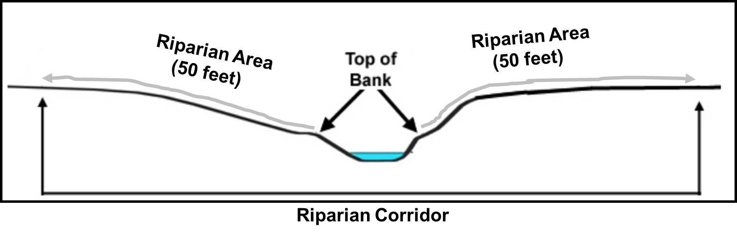
“Top of bank” means a distinct break in slope between the stream bottom and the surrounding terrain which corresponds with the ordinary high water line of the stream; or the two-year recurrence interval flood elevation.
“Trees” means a woody plant five inches or greater in diameter at breast height and 20 feet or taller.
“Water dependent” means a use or activity which can be carried out only on, in, or adjacent to water areas because the use requires access to the water body for water-borne transportation, recreation, energy production, or source of water.
“Water related” means uses which are not directly dependent upon access to a water body, but which provide goods or services that are directly associated with water-dependent land or waterway use, and which, if not located adjacent to water, would result in a public loss of quality in the goods or services offered. Except as necessary for water-dependent or water-related uses or facilities, residences, parking lots, spoil and dump sites, roads and highways, restaurants, businesses, factories, and trailer parks are not generally considered dependent on or related to water location needs. [Ord. 19-O-776 § 1 (Exh. C).]
17.74.030 Applicability.
A. Affected Property. The procedures and requirements of the riparian protection (RP) overlay zone:
1. Apply to any parcel designated as containing any portion of a riparian corridor as mapped in the City of Brookings Riparian Protection Overlay Zone Map;
2. Apply in addition to the standards of the property’s underlying zone.
3. Supersede the property’s underlying zone where the underlying zone does not provide the level of resource protection afforded by the RP overlay zone. [Ord. 19-O-776 § 1 (Exh. C).]
17.74.040 Riparian corridors.
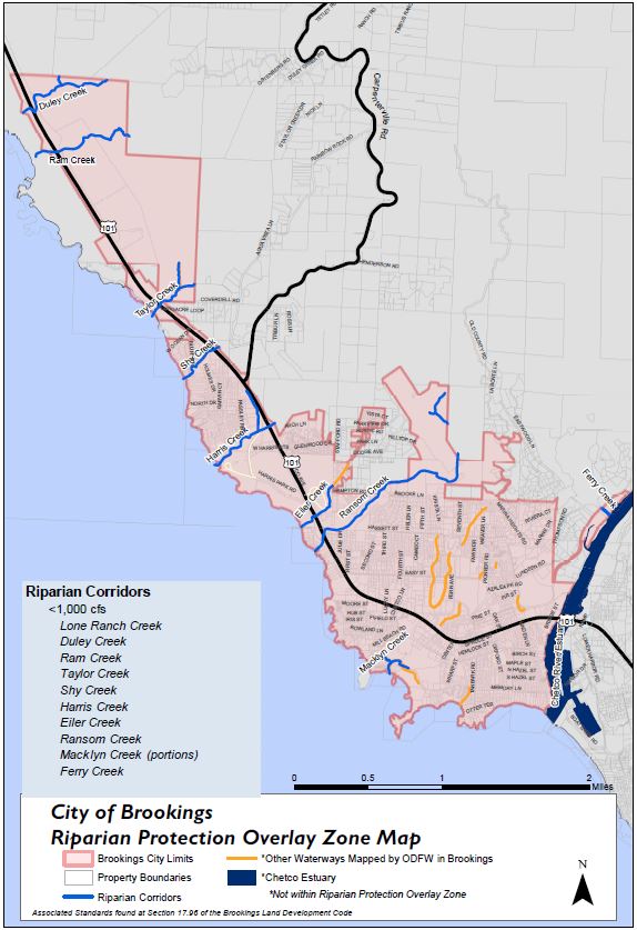
The riparian protection overlay zone identifies fish-bearing streams, lakes, and a riparian area of specified width. The following riparian corridors are to be established:
A. Along all fish-bearing lakes, and fish-bearing streams with average annual stream flow less than 1,000 cfs, the riparian area shall be 50 feet.
1. Lone Ranch Creek.
2. Duley Creek.
3. Ram Creek.
4. Taylor Creek.
5. Macklyn Creek.
6. Shy Creek.
7. Harris Creek.
8. Eiler Creek.
9. Ransom Creek.
10. Ferry Creek.
B. Along all streams with average annual stream flow greater than 1,000 cubic feet per second (cfs) the riparian corridor shall be 75 feet.
1. The Chetco River has an annual stream flow greater than 1,000 cfs.
However, the portion of the Chetco River within the city of Brookings is within the Chetco River Estuary and considered coastal shoreland, subject to the city’s marine activity district (Chapter 17.72 BMC).
C. The measurement of distance to the riparian corridor boundary shall be from the ordinary high water line measured 50 feet along the slope. [Ord. 19-O-776 § 1 (Exh. C).]
17.74.050 Administration.
A. Development submissions identified on the city of Brooking’s permit clearance form as initiating development activities in any areas designated as a riparian corridor must be accompanied by the following:
1. Site plan (in triplicate and drawn to scale) showing:
a. A delineation, prepared by a qualified professional, of the riparian corridor on the site.
b. Existing improvements such as structures, buildings, utility lines, fences, etc., for the whole site.
c. Areas where riparian area has been previously disturbed.
d. Areas where new disturbance in the riparian area is proposed.
e. Outline of trees, shrubs and ground covers.
2. Construction Management Plan. Identify how the management plan conforms to applicable requirements of the Brookings Municipal Code. Identify measures that will be taken during construction or mitigation work to protect the remaining resources at and near the construction site and a description of how the undisturbed areas will be protected. For example, describe how protective fencing will delineate the protection area, how protection zones around remaining trees will be identified and protected, erosion controls, stormwater management, and construction equipment locations and the timing of construction in relation to season.
3. Landscape Plan. In addition to the construction management plan, a landscape plan will be required for newly disturbed areas prior to issuance of permits. The plan shall include the extent of vegetation removal proposed, characteristics of the existing vegetation (types, density), proposed riparian enhancement or restoration measures, proposed alterations of topography or drainage patterns, and existing uses on the property. [Ord. 19-O-776 § 1 (Exh. C).]
17.74.060 Activities within the riparian corridor.
A. The permanent alteration of the riparian corridor by grading or by the placement of structures or impervious surfaces is prohibited, except for the following uses:
1. Streets, roads, and paths. Public or private streets, driveways, or paths may be placed within a riparian corridor to access construction activities if it is shown to the satisfaction of the reviewing authority that no other practicable method of access exists. The following standards shall apply:
a. To achieve minimum intrusion into the riparian corridor, design roads, driveways, and paths to be no wider than 20 feet and otherwise consistent with local standards for road and path construction. Crossing angle shall be no less than 90 percent perpendicular to the riparian corridor;
b. Bridges, arched culverts, or box culverts with a natural bottom shall be used for crossing of a waterway. The lower lip of any culvert must meet the channel bed at or below grade. Access for abutting lots and access through easements for adjacent lots shall be shared to minimize number of channel crossings;
c. Consider site plan elements that could facilitate access to potential new building sites and help reduce the need for subsequent encroachments into the riparian corridor. (A statement by the applicant that such elements have been considered shall satisfy this provision);
d. During construction, no stockpiling of fill materials, parking, or storage of equipment is allowed within the riparian corridor;
e. Erosion control measures, such as mulching, straw waddles, silt fences and bio-filter bags, shall be used to reduce the likelihood of sediment and untreated stormwater entering surface water, consistent with Chapter 17.100 BMC.
2. Drainage facilities, utilities, and irrigation pumps. Public and private utilities or drainage facilities may be placed within a riparian corridor if it is shown to the satisfaction of the reviewing authority that no other practicable alternative exists. If allowed the following standards shall apply:
a. The corridor necessary to construct utilities shall be the minimum width practical to minimize intrusion into the riparian corridor. Removal of trees and native vegetation shall be avoided unless alternative paths are practically impossible. The existing grade of the land shall be restored after construction. The construction corridor shall be replanted with native vegetation;
b. No stockpiling of materials, parking, or storage of equipment is allowed within the riparian corridor.
3. Water-related and water-dependent uses.
4. Replacement of existing structures with structures in the same location that do not disturb additional surface area.
5. Nonconforming uses existing fully or partially within the riparian corridor may be expanded, provided the expansion does not occur within the significant riparian corridor. Substantial improvement of a nonconforming structure in the riparian corridor shall comply with the standards of this chapter.
6. Shoreline stabilization and flood control structures that legally existed on the effective date of the ordinance codified in this chapter may be maintained. Any expansion of existing structures or development of new structures shall be evaluated by the public works/development services director (director) and appropriate state natural resource agency staff. Such alteration of the significant riparian corridor shall be approved only if less invasive or nonstructural methods will not adequately meet the stabilization or flood control needs.
B. Removal of vegetation is prohibited, except for:
1. Removal of nonnative vegetation and replacement with native plant species. The replacement vegetation shall cover, at a minimum, the area from which vegetation was removed, and shall maintain or exceed the density of the removed vegetation.
2. Removal of vegetation necessary for the development of approved uses. Vegetation removal shall be kept to the minimum necessary to allow the use.
3. Trees in danger of falling (as determined by a certified arborist) and thereby posing a hazard to life or property may be felled, following the director’s approval of the arborist’s determination.
4. Existing lawn within the significant riparian corridor may be maintained, but not expanded into the resource.
C. Exceptions. The following activities are not required to meet the standards of this section and do not require a riparian development permit:
1. Commercial forest practices regulated by the Oregon Forest Practices Act.
2. Temporary emergency procedures necessary for the safety or protection of property.
3. Normal and accepted farming practices other than the construction of buildings, structures, or paved roads.
4. Vegetation removal consistent with subsection (B) of this section.
Note to planners on herbicide use in riparian areas: Local governments are not allowed to regulate pesticide/herbicide use, but can provide information to improve compliance with state and federal law. See list of pesticides prohibited for use near salmon-bearing streams:
http://www.pesticide.org/finalproductslist.pdf
[Ord. 19-O-776 § 1 (Exh. C).]
17.74.070 Agency review.
Decisions made by the city of Brookings under this chapter do not supersede the authority of the state or federal agencies which may regulate or have an interest in the activity in question. It is the responsibility of the landowner to ensure that any other necessary state or federal permits or clearances are obtained. [Ord. 19-O-776 § 1 (Exh. C).]
17.74.080 Natural resource enhancement.
Enhancement of natural resources, such as riparian enhancement, in-channel habitat improvements, nonnative plant control, and similar projects which propose to improve or maintain the quality of a riparian resource, is encouraged; however, no enhancement activity requiring the excavation or filling of material in a waterway is allowed unless all applicable state and federal permits have been granted. [Ord. 19-O-776 § 1 (Exh. C).]
17.74.090 Variance.
In cases where the limitations on activities within the significant riparian corridor would result in the loss of reasonable economic use of a lot or parcel legally created before the effective date of the ordinance codified in this chapter, a property owner may request a variance. Granting of a variance requires findings consistent with the variance criteria outlined in Chapter 17.132 BMC. [Ord. 19-O-776 § 1 (Exh. C).]
17.74.100 Riparian Protection Overlay Zone Map
[Ord. 19-O-776 § 1 (Exh. B).]