


Chapter 18.15
TRANSPORTATION FACILITIES
Sections:
18.15.020 Privately maintained streets.
18.15.030 Nonmotorized facilities.
18.15.050 Landscaping within the right-of-way.
18.15.060 Transportation facility construction and maintenance responsibilities.
18.15.070 Formal acceptance of transportation facilities.
18.15.005 Generally.
This chapter provides information for the design of street improvements as well as nonmotorized facilities and transit infrastructure. Transportation design plans are reviewed and approved by public works. Design criteria for stormwater facilities serving transportation corridors are discussed in Chapter 18.25 CBMC.
Applicants for development and redevelopment projects that are expected to create 20 or more residential units (e.g., single-family residential lots, apartment/condo units) or 20,000 square feet or more of commercial/industrial space shall evaluate the project’s transportation system impacts in a transportation impact analysis (TIA). Such evaluations shall be prepared by a professional transportation engineer and paid for by the applicant. The TIA shall evaluate the access, circulation and other transportation requirements. The scope of TIA shall be established by public works to address issues related to a specific development proposal. See Chapter 18.40 CMC for TIA requirements.
Projects that are below the thresholds above may also be required to provide traffic analysis when, in the opinion of the public works director, a capacity problem and/or safety concern is caused and/or is adversely impacted by the development. The public works department staff shall determine the scope of this special analysis.
Trip ends shall be defined by the Institute of Transportation Engineers (ITE), Trip Generation Manual, latest edition, or trip generation studies of comparable uses prepared by an engineer and approved by the public works department staff. “Trip ends” are trips that either begin or end at the proposed land use.
Level of Service (LOS). The level of service is a measure to determine what is acceptable or unacceptable traffic flow on streets and shall be based on average seconds of delay. City streets shall maintain a LOS of “D” during the peak hour of the day. However, the developer will be responsible for making appropriate safety improvements should warrants for turn lanes, traffic signals, and/or other traffic safety improvements be met.
Mitigation. Where a development causes traffic impacts that bring a road below acceptable levels of service, or impacts a road that is already operating below acceptable levels of service, or impacts a road that has a documented safety problem, the TIA shall identify traffic impacts attributable to the development and appropriate mitigation measures. The developer may be required to implement mitigation measures as a condition of approval.
Traffic Signals. Traffic signals may be required with development when traffic signal warrants are met, in conformance with the Highway Capacity Manual and the Manual on Uniform Traffic Control Devices.
This chapter is intended to be consistent with and a supplement to the following policies and standards:
|
AASHTO |
American Association of State and Transportation Officials |
|
ADA |
Americans with Disabilities Act |
|
APWA |
American Public Works Association |
|
ASTM |
American Society for Testing and Materials |
|
MUTCD |
Manual on Uniform Traffic Control Devices |
|
OAR |
Oregon Administrative Rules |
|
ODOT |
Oregon Department of Transportation |
|
OFC |
Oregon Fire Code |
|
TSP |
Coos Bay Transportation System Plan |
|
|
Coos Bay Development Code (CBMC Title 17) |
|
CBMC |
Coos Bay Municipal Code |
|
|
Coos Bay Comprehensive Plan |
Where conflict exists between these design standards and the above referenced documents, the most stringent requirements shall take precedence. [Ord. 582 § 1, 2025; Ord. 479 § 1 (EDS § 3), 2016].
18.15.010 City streets.
(1) Street Classifications. The city has adopted the following functional classification of streets based on the context of the surrounding land use:
(a) Principal arterial (state highway under ODOT jurisdiction);
(b) Arterial street;
(c) Collector street;
(d) Neighborhood route;
(e) Local street.
Refer to the city’s transportation system plan (TSP) for a map showing the city’s functional classification street designations.
Public works will determine the classification of any new streets which are not indicated in the TSP prior to design.
(2) Vehicular Zone.
(a)(i) Vehicular Zone Cross-Section. The vehicular zone width is defined as the horizontal distance from face of curb to face of curb, measured perpendicular to the centerline. The vehicular zone includes paved travel lanes for motorized vehicles and bicycles, and may also include median spaces and paved areas for on-street parking. The width of the vehicular zone shall be sufficient to allow for the safe passage of normal multi-modal traffic and emergency vehicles.
Required lane widths and configuration are shown in the standard details. Streets should be centered within the right-of-way; however, design exceptions may be considered due to topography or other physical constraints. The city’s design exception process in CBMC 18.10.060 will apply.
|
|
|
Minimum Paving Width Curb-to-Curb |
|
Max Grade |
|||
|---|---|---|---|---|---|---|---|
|
Type of Street |
Min RoW Width |
Vehicle Travel Lane |
Median or Center Turn Lane |
On-Street Parking |
Bike Lane (a) |
Sidewalk Curb (b) |
|
|
Arterial/Collector |
|
|
|
|
|
|
|
|
5-lane (c) |
100' |
12'/11' |
14' |
– |
2 @ 6'(g) |
2 @ 6'/5' |
8% |
|
3-lane (c) |
76' |
12' |
14' (Optional) |
– |
2 @ 6'(g) |
2 @ 6'/5' |
8% |
|
2-lane |
50' |
12' |
– |
– |
2 @ 6'(g) |
2 @ 6'/5' |
8% |
|
|
|
|
|
|
|
|
|
|
28' Standard Residential |
50 |
10' |
|
1 @ 8' |
|
2 @ 5' |
|
|
36' Neighborhood Residential |
50' |
10' |
– |
2 @ 8' |
– |
2 @ 5' |
16% |
|
40' Standard Commercial/ |
60' |
12' |
– |
2 @ 8' |
– |
2 @ 5' |
16% |
|
Dead End (d) |
50' |
10' |
– |
2 @ 8' |
– |
2 @ 5' |
16% |
|
Cul-de-Sac (e) |
50' |
10' |
– |
(d) |
– |
1 @ 5' (f) |
16% (d) |
|
Alley |
|
|
|
|
|
|
|
|
1-way |
20' |
12' |
– |
– |
– |
– |
– |
|
2-way |
20' |
16' |
– |
– |
– |
– |
– |
(A) New construction: six feet; reconstruction: five feet.
(B) Wider sidewalks may be required in commercial areas.
(C) The minimum right-of-way width includes the option of two six-foot-wide landscape strips for arterials or two four-foot-wide strips for local commercial/industrial.
(D) A dead end must be less than 400 feet in length and terminate with a circular or hammerhead turnaround with a maximum grade of eight percent.
(E) No parking is permitted at the end of a cul-de-sac which must have adequate space for emergency equipment turnaround, usually a 45-foot unobstructed radius.
(F) At the end of the cul-de-sac, a five-foot sidewalk is required along the perimeter adjacent to the development.
(G) Bike lanes allowed to be reduced to five feet in width if the project is reconstruction.
(ii) Design Speed. The design speeds listed in Table 3-2 have been selected for the various street classifications. Posted speed may differ and will be designated by public works or ODOT. Designers shall use the design speed to select horizontal and vertical alignments.
|
City TSP Street Classification |
Design Speed (mph) |
|---|---|
|
Residential Local Street |
25 |
|
Collector |
35 |
|
Commercial/Industrial Local Street |
25 |
|
Arterial |
40 |
(b) Pavement Section. The minimum allowable section is as shown on standard details.
The pavement section may vary depending on soil conditions. Minimum asphalt section shall be four inches. If, in the opinion of public works, soil subgrade conditions are potentially unsuitable, soil testing and pavement design will be required. The design engineer will have the responsibility for obtaining traffic data necessary for pavement design. The ODOT Pavement Design Guide and the Asphalt Institute method are acceptable pavement design references. Concrete streets shall be designed using the guidelines and requirements of the Oregon Department of Transportation and ASTM International Standards. The creation of new, or the replacement of existing, concrete streets shall be at the discretion and approval of public works.
At a minimum, asphalt thickness shall consist of two two-inch lifts or, in the case of existing streets, match the existing thickness of thicker pavements. Lifts shall not exceed three inches. Refer to standard details for further notes and subgrade requirements.
(c) Crown. A minimum crown slope of two percent shall be provided. A standard center crown section is recommended, but a super elevated section and/or an offset crown or a curb crown (shed) configuration may be permitted with approval of public works. Maximum crown slope shall be four percent. An inverted crown section is typically not allowed, but may be considered for alleys with public works approval.
(d) Vertical Clearance. Vertical, unobstructed clearance over the traveled roadway width must be a minimum of 14 feet.
(e) On-Street Parking. On-street parking shall be provided as required in Table 3-1. The minimum dimension of a standard parallel on-street parking stall is eight feet wide all areas, by 20 feet long. Disabled on-street parking stalls may be required and must meet current ADA standards.
Where parking is restricted on one or both sides of the street, no-parking signs shall be installed by the developer. A minimum of three no-parking signs, equally spaced, are required per block. The city will maintain no-parking signs after the street is accepted by city council.
(f) Signing and Striping. Street signing and pavement markings shall be designed in accordance with the current MUTCD. Where required, the developer shall install signing and striping. The city will maintain signing and striping after acceptance of the street by city council. A sign and striping plan prepared by a qualified engineer and approved by public works is required for any new sign or pavement marking on existing facilities.
(3) Walking Zone. The “walking zone” is defined as the portion of a city street behind the face of curb that provides sidewalk, roadside landscaping, and other pedestrian travel amenities.
(a) Walking Zone Cross-Section. Improvements required within the walking zone are shown in Table 3-3. Walking zone improvements are required on both sides of the street except for infill developments of three units or less, where walking zone improvements may be omitted from one side of the street with public works approval. Sidewalk and landscaped areas within the walking zone shall have a maximum cross-slope of two percent, draining towards the street. New sidewalks shall meet all ADA requirements.
|
Street Classification |
Curb/Edge Width (Measured from Face of Curb) |
Planting Strip Configuration and Width |
Sidewalk Width |
Minimum Total Walking Zone Width |
|---|---|---|---|---|
|
28' Standard Residential and |
0.5' with 1' hardscaped edge area behind curb |
optional |
4.5' |
6' |
|
40' Standard Commercial/ |
0.5' with 1' hardscaped edge area behind curb |
4' planting strip |
4.5' |
10' |
|
Collector |
0.5' with 1' hardscaped edge area behind curb |
optional |
4.5' |
7' |
|
Arterial |
0.5' with 1' hardscaped edge area behind curb |
|
5.5' |
7' |
|
Arterial |
0.5' with 1' hardscaped edge area behind curb |
6' planting strip |
5.5' |
13' |
(b) Curb, Gutter and Edge Area. Standard curb is required on both sides of streets within the city of Coos Bay. Rolled curb is not allowed unless approved through the design exception process described in CBMC 18.10.060.
(c) Sidewalk. Sidewalks are required on both sides of the street. Sidewalks shall be constructed of concrete. Curb ramps meeting ADA requirements are required at all intersections and commercial driveways.
Placement of utility poles, hydrants and other obstructions should avoid sidewalk areas. Any sidewalk obstruction requires the prior approval of public works and a minimum unobstructed clear passage width of 36 inches must be maintained around any obstruction.
The standard sidewalk longitudinal grade and cross slope shall comply with current ADA standards. The back of sidewalk grade shall be maintained parallel to the gutter grade at driveways. In some locations where the elevation of the adjacent property is much lower than the street, a dip in the sidewalk may be permitted. In this case, the driveway shall have the standard one-half-inch lip and slope at a two percent (maximum) grade towards the street. The transition from the driveway back to the normal sidewalk grade shall be in accordance with ADA slope requirements.
(d) Grading Adjacent to Sidewalks. Chapter 18.30 CBMC applies to grading activities. Slopes behind the sidewalk shall start one foot beyond the edge of the sidewalk or curb and shall not be steeper than 1.5:1 (horizontal: vertical) in a cut condition and 2:1 for a fill condition with cohesive soils. Sand or other noncohesive soils shall be sloped no steeper than 3:1. It is the owner’s responsibility to grade responsibly and the owner is ultimately responsible for any damage to a public sidewalk.
If a grading plan is required, the design professional’s recommendations may replace the above slope requirements with the approval of public works.
A pedestrian guardrail or barrier shall be installed when the slope within two feet of the back of a sidewalk exceeds 2:1 for a height of 30 inches or greater. Protection for pedestrians is recommended when slopes are vertical and exceed 18 inches in height. Pedestrian guardrail shall meet or exceed the minimum requirements of the current edition of ODOT Standards.
(4) Horizontal Alignment of Streets. The centerline of street improvements shall coincide with the centerline of the public right-of-way unless approved by public works.
Minimum centerline curve radius shall be as follows:
|
Design Speed (mph) |
Minimum Horizontal Curve Radius (ft) |
|---|---|
|
25 |
200 |
|
30 |
300 |
|
35 |
480 |
Centerline radii of curves shall not be less than 200 feet on collectors, or 100 feet on local streets, and shall be designed to an even 10 feet.
Super-elevation may be allowed for the purpose of reducing minimum required radius providing that it can be shown that there are no adverse impacts on access to adjacent property, storm drainage and intersections.
Sufficient sight distance must be provided to allow drivers time to avoid obstacles, other vehicles or people in their path. Sight distance shall be considered in horizontal alignment design. Stopping sight distances shall be provided in accordance with the following table:
|
Design Speed (mph) |
Required Stopping Sight Distance (ft) |
|---|---|
|
25 |
155 |
|
30 |
200 |
|
35 |
250 |
|
Adapted from AASHTO Table 3-1 |
|
(5) Vertical Alignment of Streets. Minimum longitudinal grade of streets shall be one percent. Maximum street grades are shown in the following table:
|
Street Classification |
Maximum Grade (%) |
|---|---|
|
Residential Local |
12 |
|
Collector |
10 |
|
Commercial/Industrial Local |
10 |
|
Arterial |
8 |
Vertical curves shall be provided at changes of grade exceeding two percent and shall provide the stopping sight distance required in Table 3-5. The grade of the through street at intersections shall be maintained through the intersection. Intersecting streets shall match the curb flow line of the through street and be provided with a landing area. The landing shall extend 25 feet from the pavement edge of the through street and have a grade of five percent or less. Alternative geometry may be necessary at intersections on steep slopes and should be coordinated with public works.
Streets shall be graded to provide adequate stormwater drainage in accordance with subsection (11) of this section and Chapter 18.25 CBMC to minimize standing water. Special care should be taken in the design of vertical curves to avoid long flat grades at the crest or sag of curves.
Curb or gutter grade information shall be provided in design plans for curb returns at intersections and for cul-de-sacs.
Due to the challenging topography in parts of the city, consideration will be given to exceeding vertical alignment standards providing that it can be shown that there will be no adverse impacts on traffic safety and emergency vehicle access. Requests for modification of standards shall be submitted in accordance with the design exception process provided in CMBC 18.10.060. Design exception requests shall include numeric and graphical sight distance analyses showing existing topographic features that are proposed to remain after development of the street, as well as any future features anticipated. Road grade design exceptions require approval of both public works and the city’s fire code official.
(6) Roadway Intersections.
(a) Intersection Geometry. The interior angle between centerlines at intersecting streets shall be kept as near to 90 degrees as possible and in no case shall it be less than 75 degrees. As far as practical, all streets other than minor streets shall be in alignment with existing streets by continuations of the centerlines thereof. Staggered street alignment resulting in “T” intersections shall wherever practical leave a minimum distance of 200 feet between the centerlines of streets having approximately the same direction and otherwise the centerlines of intersecting streets shall be spaced at least 150 feet apart.
Horizontal point of curvature (PC) must be located a minimum of 25 feet from the right-of-way of intersecting streets.
An arterial or collector street intersecting with another street shall have at least 100 feet of tangent adjacent to the intersection unless topography requires a lesser distance. Other streets, except alleys, shall have at least 50 feet of tangent adjacent to the intersection.
The curb radius at the intersection of two streets shall be as shown in Table 3-7, unless otherwise approved by public works.
|
Approach/Entering Street at Intersection |
⇨ |
No Parking or Bicycle Lane |
With Bicycle Lane |
With Parking Lane |
Both Parking and Bicycle Lane |
|---|---|---|---|---|---|
|
Exiting Street |
⇩ |
Design Curb Radius (ft) |
|||
|
No Parking or Bicycle Lane |
30 |
25 |
20 |
10 |
|
|
With Bicycle Lane |
25 |
12 |
8 |
5 |
|
|
With Parking Lane |
20 |
8 |
5 |
5 |
|
|
Both Parking and Bicycle Lane |
10 |
5 |
5 |
5 |
|
The intersection of more than two streets at any one point is not allowed.
Bulbed-out intersections for improved pedestrian crossings may be required at intersections specified by public works. Additional traffic calming measures may be required by public works.
(b) Clear-Vision Area. It is intended to ensure that all intersections and nonresidential driveways shall have an unobstructed sight distance along any approach not protected by a traffic signal. A vision clearance triangle shall be created sufficient to avoid vehicle conflicts for all approaching or departing vehicles traveling at or less than the maximum speed limit. Right-turning vehicles shall not be considered protected by a traffic signal.
The required vision clearance triangle shall be a sight distance as specified in Chapter 9, Intersections, of the American Association of State Highway and Transportation Officials (AASHTO) Edition of “A Policy on Geometric Design of Highways and Streets” in the minimum dimensions listed in Table 3-8, Vision Clearance Triangle – Minimum Dimensions (also see Standard Detail T-19 for an example). At signalized intersections, Dimension B shall be as provided in Table 3-8, and Dimension C shall be 50 feet. The minimum standard in Table 3-8 may be increased by public works for locations where it has been determined by an engineering report that the minimum standards listed do not provide a safe sight distance.
|
MPH |
Street Width |
Vision Clearance Triangle Distance (Feet) |
|
|---|---|---|---|
|
A |
B |
C |
|
|
25 |
30 |
140 |
95 |
|
36 |
125 |
90 |
|
|
40 |
115 |
85 |
|
|
48 |
165 |
85 |
|
|
56 |
145 |
80 |
|
|
30 |
30 |
170 |
115 |
|
36 |
155 |
110 |
|
|
40 |
145 |
105 |
|
|
48 |
200 |
105 |
|
|
56 |
180 |
100 |
|
|
35 |
30 |
205 |
135 |
|
36 |
185 |
130 |
|
|
40 |
175 |
125 |
|
|
48 |
240 |
125 |
|
|
56 |
215 |
120 |
|
|
40 |
30 |
235 |
160 |
|
36 |
215 |
150 |
|
|
40 |
205 |
145 |
|
|
48 |
275 |
145 |
|
|
56 |
250 |
135 |
|
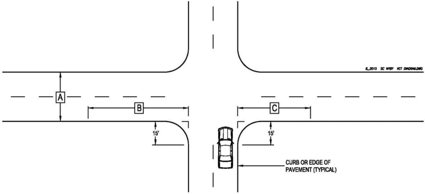
Requirements for the establishment of a vision clearance triangle are as follows. Between a height of two feet and 10 feet, as measured from the edge of the adjoining roadway, a required vision clearance triangle shall be free of all structures, fences, vegetation, signs, retaining walls, cut slopes and any other sight obstruction, which either individually or collectively obscure an area in excess of 18 inches in width. Legally parked vehicles shall not be considered sight obstructions in the vision clearance triangle.
Exceptions to this requirement may be granted by public works if an item proposed to be located within the vision clearance triangle is determined not to constitute a sight obstruction; however, no exceptions may be granted within the first 50 feet of the vision clearance triangle as measured along distances B or C as set forth in Table 3-8.
(7) Illumination and Signalization. Public works will consider factors such as traffic, crash data, and roadway characteristics to support lighting installation decisions. AASHTO provides the threshold or minimum conditions of when to consider lighting. Refer to the ODOT Lighting Policy and Guidelines.
Due to limited resources, the city will not install, pay for power, or maintain new street lights in existing improved right-of-way. The city may consider paying for power and maintenance of new street lights installed in dedicated street right-of-way as part of the acceptance of new subdivision infrastructure. Where specialty light fixtures are desired, financial responsibility for monthly power and maintenance costs shall be determined prior to design approval.
Signals shall be designed by a professional engineer in accordance with the ODOT Traffic Signal Design Manual.
(8) Access to City Streets. Proposed driveway or private street access to a city street requires a permit from the city. State highway access requires a permit from ODOT.
(a) Driveway Access. Driveways/access shall meet the requirements of CBMC Title 17. Driveways greater than 150 feet in length shall meet the design requirements for private streets provided in CBMC 18.15.020.
Maximum and minimum driveway dimensions are detailed in Table 3-9.
|
Property Frontage |
Minimum width (ft) |
Maximum width for single driveway (ft) |
Maximum width each for two driveways (ft) |
|---|---|---|---|
|
Less than 50 feet |
12 |
20 |
N/A |
|
50 to 75 feet |
12 |
25 |
20 |
|
More than 75 feet |
12 |
30 |
20 |
|
Widths in this table do not include sloped wings. |
|||
Design and construction of the driveway apron shall conform to details in Chapter 18.35 CMC. Driveways shall meet applicable ADA guidelines.
Requests for additional or wider driveways other than those allowed above must be approved through the design exception process (see CBMC 18.10.060).
Restrictions may be imposed on additional driveways, such as limited turn movements, shared access between uses, closure of existing driveways or other access management actions.
(i) The following will be considered for requests to install additional residential driveways on local streets:
(A) Residentially zoned lots having a single-family residential use (does not apply to nonconforming uses, e.g., commercial use on residential zoned property) accessing a paved local street (per the transportation system plan). The intent of this policy is to allow public works staff to consider permitting a second driveway access to a single-family residence with a lot having adequate frontage to meet sight visibility standards and to maintain space for on-street parking. Multiple driveways associated with unpaved streets shall be handled on a case-by-case basis.
For consideration of a second driveway access to a single-family residential lot:
1. Lot must be residentially zoned.
2. Lot must have an existing single-family residential use.
3. Second driveway access must be at least five feet (measured flair edge to property line) from lot property line.
4. Not more than 50 percent (not including the flairs for the second driveway) of any side of any residential lot may be used for driveway accesses.
5. At least 20 (measured flair edge to flair edge or property line) continuous feet of non-driveway access area must remain on any one side of any residential lot after construction of a second driveway for on-street parking.
6. Adequate sight distance shall be required and it shall be measured where the driveway access meets the sidewalk or paved street (as appropriate).
7. Second driveway must be paved.
8. Second driveway access, which must be a minimum of 10 feet in width, with five-foot-wide flair on each side of the driveway, must be at least 20 feet from the existing driveway.
(B) Joint usage (shared) driveways may be considered where sufficient spacing is not available. This may be from a driveway connected to an adjoining property that has direct access to a public street or where the access straddles property lines. An access easement covering the driveway shall be recorded in this case to assure access to the closest public street for all users of the driveway. The easement agreement shall also address construction and maintenance responsibilities along with other items that may be worthy of consideration on a case-by-case basis.
For consideration of a joint usage (shared) driveway as a second driveway access to a single-family residential lot:
1. Lots must be residentially zoned.
2. Lots must have a single-family residential use.
3. When new access is being constructed for a joint usage driveway, the access must be at least 20 feet (measured flair edge to flair edge) from any existing driveway.
4. Not more than 50 percent (not including the flairs for second driveway) of any side of any residential lot may be used for driveway accesses.
5. At least 20 (measured flair edge to flair edge or property line) continuous feet of non-driveway access area must remain on any one side of any residential lot after construction of a second driveway for on-street parking.
6. Minimum secondary driveway width is 10 feet.
7. Adequate sight distance shall be required and it shall be measured where the driveway access meets the sidewalk or paved street (as appropriate).
8. Reciprocal easements must be recorded in the deed records of all properties involved in a shared driveway. All parties must sign the service driveway/access permit application.
(ii) The following will be considered for requests to install additional residential driveways on collector and arterial streets.
(A) Residentially zoned lots having a single-family residential use (does not apply to nonconforming uses, e.g., commercial use on residential zoned property) accessing a collector or an arterial street (per the transportation system plan). Generally, second driveway access from the same parcel onto a collector or an arterial street will be denied (however, a second driveway access may be considered for the purposes of constructing a circular driveway). The applicant’s request for the additional access shall be accompanied by a site drawing indicating the dimensions, radius, distance between existing driveways and property lines, and other information necessary for staff to determine the feasibility and safety of the proposed driveway.
(b) Access from Alleys and Private Streets. Alley and private street connections to the public street shall be designed in accordance with guidance to be provided by public works or standard details in Chapter 18.35 CMC.
(c) Controlled Access. Controlled or gated access is not permitted on public or private streets except as approved for emergency-only access or public utility access. Gated communities and gated neighborhoods may be considered on a case-by-case basis. Any proposed controlled access devices will be evaluated through the design exception process.
(9) Cul-de-Sacs. Dead-end streets over 150 feet in length shall terminate in an approved turnaround acceptable to the fire marshal and public works to provide adequate emergency vehicle access. The maximum length of a dead-end street shall be 400 feet unless approved through the design exception process (see CBMC 18.10.060). This length shall be measured from the centerline of the intersecting street along the centerline of the dead end street to the center of the turnaround.
No islands or other obstructions are allowed in the centers of cul-de-sacs.
The entire cul-de-sac or hammerhead must be contained within the public right-of-way and signed appropriately to restrict parking. Refer to subsection (2)(f) of this section for information regarding sign installation responsibilities.
(10) Alleys. Alleys must be a minimum of 20 feet wide with a five-foot curb radius at the intersection of the public road. Alleys shall be constructed using the pavement section required for residential local streets.
(11) Roadway Drainage. Stormwater disposal from streets requires a collection and piping system. Roadway storm drain facilities shall be separate from the city’s sanitary sewer lines. Discharge points for all roadway storm drains shall be approved by public works. Refer to Chapter 18.25 CBMC for stormwater system design standards.
Bioswales and other stormwater infiltration systems shall be employed only in streets in areas designated by public works. Bioswales (where allowed) shall be designed in accordance with Chapter 14, Appendix B of the ODOT Hydraulics Manual. Landscaping of bioswales (where allowed) shall meet the standards provided in CBMC 18.15.050. [Ord. 479 § 1 (EDS § 3.1), 2016].
18.15.020 Privately maintained streets.
The city will not construct or add to its existing inventory of city maintained streets or access roads unless they meet all standards provided in CBMC 18.15.010. However, in cases where public street standards cannot be met, the developer may elect, with concurrence by public works, to construct a privately maintained access road to serve an infill development. Said privately maintained access road shall be constructed on private property.
Privately maintained streets and access roads may be developed exclusively within private property and the following conditions shall apply:
(1) The maximum number of dwelling units potentially served by the access road shall be three. Streets having the potential to serve more than three dwelling units must meet the requirements in CBMC 18.15.010.
(2) Sidewalks are not required.
(3) The street or access road surface must be constructed of an all-weather surface, as approved by public works and the city fire code official.
(4) The first 25 feet linear feet of the intersection/access point to the city street shall be paved.
(5) Any new development on a private street shall have a fire suppression system approved by the city fire code official.
(6) The traveled way of a private road shall be designated as a fire lane under the Oregon Fire Code. Private streets must have a minimum of 20 feet unobstructed width with 14 feet of vertical clearance.
(7) With the approval of the city fire code official, the travel surface of the access road may be reduced to 16 feet if two or three dwelling units will be served, or 14 feet if only one dwelling unit will be served. The total length of any access road with a reduced pavement width must be 400 feet or less. Access roads in excess of 400 feet must have a paved surface at least 20 feet wide.
(8) A standard turnaround shall be required at any dead end. (See CBMC 18.15.010(9).)
(9) A maximum profile grade of 12 percent is allowed.
(10) All runoff from new access roads must be controlled and directed to appropriate storm drains, or existing natural drainage channels. Connection to a natural drainage requires public works approval.
(11) Construction of privately maintained improvements within existing public rights-of-way must not obstruct or reduce access to existing homes.
(12) The developer shall arrange for future maintenance and repair of the access road, through a recorded road maintenance agreement or other legal mechanism to ensure perpetual maintenance. The maintenance agreement shall be binding upon all subsequent property owners and shall clearly specify that the city may remove any road improvements as needed to construct, repair or maintain city utilities in the right-of-way or easements. Restoration or repair of any roadway damage caused by city utility work will be the responsibility of the parties to the maintenance agreement.
(13) Street improvements constructed in the public right-of-way shall be positioned to allow for future widening, if additional development is anticipated.
(14) Developers shall install their own signs in accordance with the MUTCD and city standards, including a street identification sign at all intersections. Public works approval is required when installing signs at intersections with public roads. Once installed, the city will assume maintenance responsibility for traffic control signs and devices and street name signs located at the intersection with a city street. The city will not furnish, install or maintain other signs for private streets. [Ord. 479 § 1 (EDS § 3.2), 2016].
18.15.030 Nonmotorized facilities.
(1) Sidewalks. Sidewalks in city street corridors shall be designed in accordance with CBMC 18.15.010(3).
(2) Bicycle Facilities. Bicycle facilities in city street corridors shall be designed in accordance with CBMC 18.15.010(2)(a).
(3) Multi-Use Pathways. Multi-use pathways within the city are intended for nonmotorized use by bicycles and pedestrians. As land is developed, publicly accessible multi-use pathways may be required by the city’s community development department to facilitate nonmotorized circulation and connectivity. ADA requirements apply to these facilities. Design of new multi-use pathways shall include logical connections to existing or planned pedestrian and bicycle facilities in street corridors.
General requirements for multi-use pathways are provided in Table 3-10. For additional design guidance, refer to the AASHTO Guide for the Development of Bicycle Facilities, and the Oregon Bicycle and Pedestrian Design Guide.
|
Pathway Element |
Requirements |
|---|---|
|
Surfacing |
Stable, firm and slip resistant. Asphalt or concrete are preferred. Other materials require public works approval. |
|
Maximum Longitudinal Slope |
5% |
|
Maximum Cross Slope |
2% |
|
Clear Width |
10' minimum; 12' preferred; in areas of significant walking or biking demand the clear width should be 16'. |
(4) Public Stairways. New pedestrian facilities and alterations to existing pedestrian facilities within the public right-of-way shall conform to ADA standards. Due to the city’s topographical setting however, hillside conditions may constrain modification or addition of pedestrian features in full and strict compliance with minimum ADA standards. In cases where ADA compliance is technically infeasible, stairway access for pedestrians may be considered by public works. Where allowed, public stairways shall conform to ADA requirements for general site and building elements.
(5) Street Crossings. Developers are required to provide enhanced street crossings on roadways with high traffic volumes and/or speeds in areas with nearby transit stops, residential uses, schools, parks, shopping and employment destinations. These crossings shall include treatments such as marked crosswalks, high visibility crossings, and/or curb extensions as determined by public works. [Ord. 479 § 1 (EDS § 3.3), 2016].
18.15.040 Transit facilities.
Developers shall provide documented coordination with Coos County Area Transit, the local transit provider, with regard for design of street and other transportation facilities that are located within 100 feet of existing or planned transit routes and stops. ADA-accessible transit stop improvements, pedestrian connections to transit stop locations and furnishings such as shelters, benches, bicycle racks and/or other amenities may be required by public works. [Ord. 479 § 1 (EDS § 3.4), 2016].
18.15.050 Landscaping within the right-of-way.
In addition to the guidelines in this section, landscaping within the right-of-way must meet the requirements of Coos Bay Municipal Code.
(1) General Requirements. Landscaping within the right-of-way may be a requirement of a development or installed at the request of property owners. If landscaping is a requirement of a development, it may only be removed if it is replaced elsewhere and approved by the public works and community development director, or their designee.
Landscaping within the right-of-way must be maintained by the adjacent property owner. Irrigation in the right-of-way must comply with the OPSC and also be maintained by the adjacent property owner.
(2) Clearance. Landscaping within the right-of-way must meet the clear-vision area requirements found in CBMC 18.15.010(6)(b). Vegetation must be maintained so all branches and foliage are removed to a height of seven feet above the sidewalk and 14 feet above the roadway.
(3) Street Tree Installation and Types. Street tree installation and types shall be in conformance with Chapter 8.30 CBMC and the city’s urban forestry plan. [Ord. 503 § 1 (Exh. B), 2018; Ord. 479 § 1 (EDS § 3.5), 2016].
18.15.060 Transportation facility construction and maintenance responsibilities.
Developers are responsible for constructing, signing and striping new street facilities and improving existing roadways as required for developments such as subdivisions and commercial buildings. Maintenance of roadway improvements within dedicated right-of-way is the responsibility of the developer (or designated private parties) until formal acceptance of the roadway by city council. Any nonstandard roadway within the right-of-way that is not accepted by the city council must be maintained by the developer (or designated private parties) in perpetuity or until the roadway is improved and accepted by city council. Maintenance responsibility needs to be documented, recorded and a copy provided to the city prior to any final inspections or occupancy of the associated development.
Transportation facilities within the vehicular zone of street corridors that are located within the public right-of-way and that are formally accepted by city council are maintained by the city. This includes pavement, gutter, signing, striping and signalization. State highways are maintained by ODOT.
Transportation facilities within the walking zone of street corridors are maintained by adjacent property owners.
Private roads and alleys must be maintained in perpetuity by the developer, adjacent property owners, homeowners association or other designated party. A maintenance agreement shall be submitted to the city with any new development project.
|
Facility |
Location |
Accepted by City Council? |
Maintenance Responsibility |
|---|---|---|---|
|
Standard street vehicular zone improvements |
Public right-of-way (ROW) |
Yes |
City |
|
Standard street walking zone improvements |
Public ROW |
Yes |
Private1 |
|
Substandard street, private street or alley |
Public ROW |
No |
Private1 |
|
Multi-use pathway |
Public ROW, easement or tract |
TBD2 |
TBD2 |
|
State highway |
State ROW |
N/A |
ODOT |
|
1Adjacent property owners for sidewalk, owners of properties served by the substandard street, private street or alley, or other designated parties |
|||
|
2To be determined prior to design approval |
|||
[Ord. 479 § 1 (EDS § 3.6), 2016].
18.15.070 Formal acceptance of transportation facilities.
Approval of the final plat or map shall not constitute an offer by the applicant or acceptance by the city of any public improvements or monumentation. Upon completion of the improvements and post-monumentation, the applicant shall submit all items identified in CBMC Title 17. The following minimum record drawings shall be submitted to public works:
(1) One copy of street and sanitary/storm sewer plan profiles.
(2) One mylar of the certified post-monumentation plan.
Public works department staff shall review the material and indicate approval of the post-monumentation by signing the affidavit on the final plat or map.
Only improvements that have been constructed in accordance with city standard specifications (latest edition of Oregon Standard Specifications for Construction) and inspected and approved by public works shall be recommended for council acceptance by public works (also see CBMC 18.10.090). Upon city council passing a resolution confirming acceptance of the public improvements, the city will provide a formal letter of acceptance. The city will not maintain or repair any facilities until they have been formally accepted. [Ord. 479 § 3.7 (EDS § 1), 2016].