


Chapter 17.36
DESIGN STANDARDS
Sections:
17.36.010 Compliance required.
17.36.030 Subdivision roads and public ways.
17.36.050 Maintenance of roads.
17.36.010 Compliance required.
A land division, by subdivision, creation of a street or other right-of-way, or planned unit development, shall be in compliance with the design standards set forth by this title.
(1) Purpose. The purpose of these standards is to ensure that roads be constructed according to minimum standards. The construction of roads to these standards is one requirement for possible acceptance by the county as a “county road” but does not assure acceptance by the county court.
(2) Definitions.
(a) “Public road” means a road that has been dedicated for public use or has been adjudicated by the circuit court as a public road.
(b) “County road” means a road that has been accepted as a “county road” by formal action of the county court. After acceptance, the road will be maintained by the county.
(c) “Driveway” is an access road serving only two permanent residences. No construction standard is required; provided, however, approval is required as provided in CCC 17.36.020(1)(d).
(3) Compliance Required. Except with respect to a driveway, all roads constructed as public or private roads shall be in compliance with the design standards set forth by this title. (Ord. 194 §§ 1, 2, 2008; Ord. 19 § 8.010, 2003)
17.36.020 Road standards.
(1)(a) General. The location, width and grade of streets shall be considered in their relation to existing roads, to topographical conditions, to public convenience and safety, and to the proposed use of land to be served by the road. The road system shall assure an adequate traffic circulation system with intersection angles, grades, tangents and curves appropriate for the traffic to be carried considering the terrain. The proposed road location and pattern shall be shown on a development plan and the arrangement of roads shall either:
(i) Provide for the continuation or appropriate projection of existing roads in surrounding areas; or
(ii) Conform to a plan for the neighborhood approved or adopted by the planning commission to meet a particular situation where topographical or other conditions make continuance or conformance to existing roads impractical.
(b) Where the plat submitted covers only a part of the subdivider’s tract, a drawing of the prospective future road system of the entire tract shall be furnished.
(c) Where a tract is subdivided into lots of an acre or more in area, the commission may require an arrangement of lots and roads such as to permit a later resubdivision in conformity to the requirements contained in this title.
(d) Any new road shall, prior to county approval, be approved in writing by emergency service providers identified by the county for sufficiency of access and road surface for emergency services purposes.
(2) Existing Roads. Whenever existing roads, adjacent to or within a tract, are of inadequate width, additional right-of-way shall be provided at the time of the land division by the developer. During consideration of the tentative plan for a subdivision, the commission shall determine whether improvements to existing roads, adjacent to or within the tract, are required and may require such improvements as a condition of approval of the tentative plan.
(3) Minimum Right-of-Way and Roadway Width. Roads shall be constructed according to the standards and specifications set forth in this title. Roads to be constructed within the urban growth boundary shall be constructed in compliance with the applicable city street improvement standards and specifications.
(4) Reserve Strips. Reserve strips or street plugs controlling access to streets will not be approved unless deemed necessary by the commission for the protection of public safety and welfare.
(5) Alignment. All proposed streets shall be in alignment with existing streets by continuations of the center lines thereof. Offset street alignment resulting in “T” intersections shall have a minimum distance of 200 feet between the center lines of opposite streets of approximately the same direction unless prohibited by topographical features; however, in no case shall any center line offset of less than 100 feet be permitted.
(6) Future Extensions of Streets. When necessary to give access to or permit a satisfactory future division of adjoining land, streets shall be extended to the boundary of the subdivision or partition and the resulting dead end streets may be approved without a turnaround. Reserve strips and street plugs may be required to preserve the objectives of street extensions.
(7) Intersection Angles. Streets shall be laid out to intersect at angles as near to right angles as practical, except where topography requires a lesser angle. In no case shall the acute angle be less than 80 degrees unless there is a special intersection design. An arterial or collector street intersecting with another street shall have at least 100 feet of tangent adjacent to the intersection unless topography requires a lesser distance. Other streets, except alleys, shall have at least 50 feet of tangent adjacent to the intersection unless topography requires a lesser distance. The intersection of more than two streets at any one point will not be approved.
(8) Half Street. Half streets, while generally not acceptable, may be approved where essential to the reasonable development of the subdivision or partition when in conformity with other requirements of these regulations and when the planning commission finds it will be practical to require the dedication of the other half when the adjoining property is divided. Whenever a half street is adjacent to a tract to be divided, the other half of the street shall be provided within such tract. Reserve strips and street plugs may be required to preserve the objectives of half streets.
(9) Street Names. Except for extensions of existing streets, no street name shall be used which will duplicate or be confused with the name of an existing street in the city or county. Street names and numbers shall conform to the established pattern in the city and shall be subject to the approval of the planning commission.
(10) Grades and Curves. Grades shall not exceed six percent on arterials, eight percent on collector streets or 10 percent on other streets. Center line radii of curves shall not be less than 300 feet on other streets, and shall be to an even 10 feet. Where existing conditions, particularly the topography, make it otherwise impractical to provide buildable sites, the planning commission may accept steeper grades and sharper curves. In flat areas, allowance shall be made for finished street grades having a minimum slope, preferably, of at least 0.5 percent.
(11) Marginal Access Streets. Where a land division abuts or contains an existing or proposed collector or arterial street, the planning commission may require marginal access streets, reverse frontage lots with suitable depth, screen planting contained in a non-access reservation along the rear of side property line, or other treatment necessary for adequate protection of residential properties and to afford separation of through and local traffic.
(12) Alleys. Alleys shall be provided in commercial and industrial districts, unless the planning commission approves other permanent provisions for access to off-street parking and loading facilities. The minimum width of an alley in a residential block when platted shall be 16 feet. Alleys shall be provided in commercial and industrial districts and shall not be less than 20 feet. The corner of all alleys shall be curved with a radius of not less than 10 feet.
(13) Access Crossing Public Lands. Where the provisions of public access requires the crossing of public lands, approval shall be obtained of the subdivision from the agency having jurisdiction over said public lands crossed prior to commission approval of the preliminary plat.
(14) Access of State Highway. Where a subdivision requires an access approach to a state highway, approval shall be obtained by the subdivider from the State Highway Department prior to commission approval of the preliminary plat.
(15) The current editions of the following shall, in addition to any other provisions of this code, be the standards for road design and construction in Crook County: Geometric Design of Highways and Streets (American Association of State Highway and Transportation Officials); Road Design Guide (American Association of State Highway and Transportation Officials); Manual on Uniform Traffic Control Devices for Streets and Highways (American Association of State Highway and Transportation Officials); and the Oregon Department of Transportation Oregon Standard Specifications for Construction.
(16) Pedestrian Access and Circulation. In addition to the access and connectivity standards required by subsections (13), Access Crossing Public Lands, and (17), Cul-De-Sacs, of this section, subdivisions subject to Chapter 17.28, 18.48 or 18.52 CCC shall meet the applicable pedestrian access and circulation standards in Chapter 18.184 CCC, Pedestrian and Transit Improvements.
(17) Cul-De-Sacs.
(a) For subdivisions subject to Chapter 17.28, 18.48 or 18.52 CCC, a cul-de-sac street shall only be permitted where the county planning department, in consultation with the county roadmaster and Crook County fire and rescue, determines that environmental or topographical constraints, existing development patterns, or compliance with other applicable county requirements preclude a street extension.
(b) Where the county determines that a cul-de-sac is allowed, all of the following standards shall be met:
(i) The cul-de-sac shall not exceed a length of 400 feet, except where the county roadmaster determines that topographic or other physical constraints of the site require a longer cul-de-sac. The length of the cul-de-sac shall be measured along the centerline of the roadway from the near side of the intersecting street to the farthest point of the cul-de-sac.
(ii) The cul-de-sac shall terminate with a circular or hammer-head turnaround meeting the Uniform Fire Code.
(iii) The cul-de-sac shall provide, or not preclude the opportunity to later install, a pedestrian and bicycle accessway between it and adjacent developable lands. Such accessways shall conform to subsection (13) of this section.
(18) For existing parcels lawfully created before land development requirements (prior to December 17, 1973), Crook County will accept applications for site plan approval without proof of legal access and without compliance with otherwise applicable road standards. This exception shall not apply to applications to partition even if the original parcel was created prior to December 17, 1973. Furthermore, this chapter shall not apply to any property however created after December 17, 1973. (Ord. 321 § 3, 2020; Ord. 310 § 1, 2019; Ord. 303 § 1 (Exh. C), 2017; Ord. 194 § 3, 2008; Ord. 149 Amd. 1 §§ 15, 16, 17, 2006; Ord. 19 § 8.020, 2003)
17.36.030 Subdivision roads and public ways.
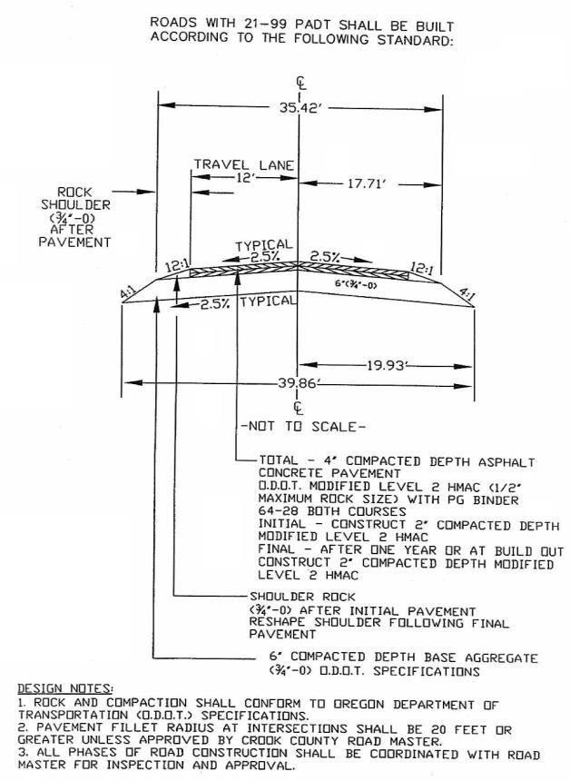
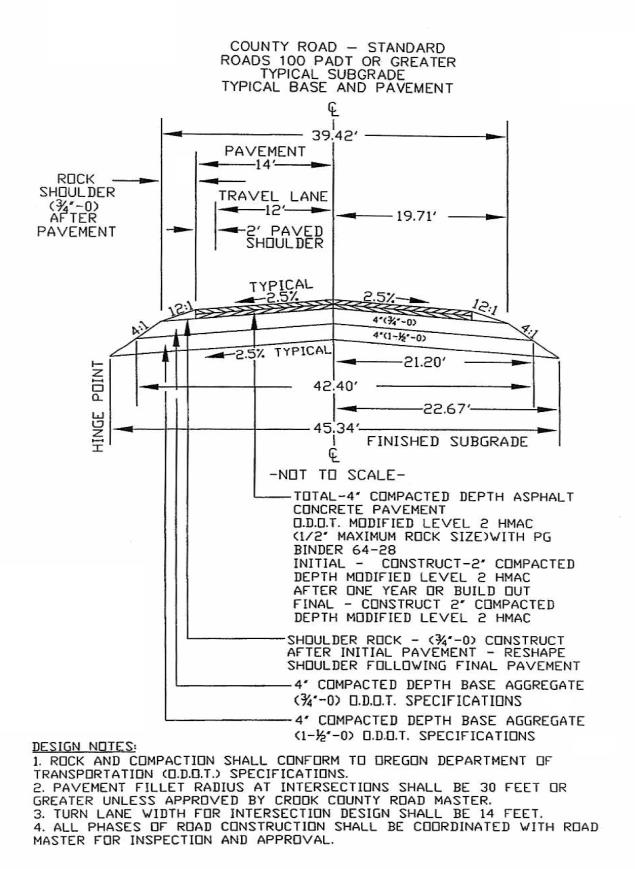
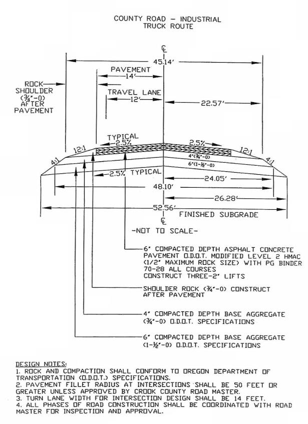
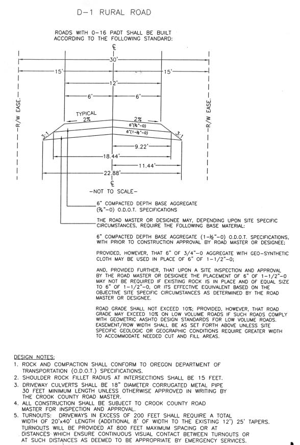
(1) Right-of-Way and Roadbed Standards. The right-of-way and roadbed standards shall be determined in accordance with Exhibit D at the end of this section. If a road located in an EFU-2 or EFU-3 zone will not serve more than four residences, the roadbed width and standards shall be determined in accordance with Exhibit D-1.
(2) Repealed by Ord. 149 Amd. 1.
(3) Modifications from Standards. Prior to submittal of a partitioning or subdivision application to the planning department, the planning director, in consultation with the roadmaster and any other designated person by the county, may authorize modifications from the foregoing standards where it can be shown that owing to special and unusual circumstances related to a specific road a lesser level of improvements will provide the same quality road as the standards contained within this title. This modification standard applies to planned unit developments in regard to which the planning commission recognizes the importance of design flexibility and therefore the planning commission may approve road specifications that meet the design requirements for such developments but differ from these standards.
(4) Grade. Maximum allowable grade shall be eight percent.
(5) Drainage. Adequate drainage for the main roadbed and all approach roads shall be provided by utilization of proper and necessary size culverts. Culvert size shall be a minimum of 15 inches. All culverts shall extend a minimum of three feet beyond the roadbed. Drainage plans shall comply with all applicable standards required by the State of Oregon Department of Environmental Quality Central Oregon Stormwater Plan or as specified by the planning department.
(6) Other Specifications. Roadbed crown, slope shoulders, base rock, and HMAC shall be provided as specified in the applicable standards in Exhibit D at the end of this section.
(7) Inspections and Testing. Developer shall provide the planning department with testing of any and all materials used in developing roads. Such testing shall be performed by a state of Oregon certified laboratory and shall be at the developer’s expense.
(8) Roadside Parking. In the event roadside parking is required or permitted, additional right-of-way and/or road surface may be required.
(9) The Developer. Prior to the start of construction (any earth moving) the developer shall supply the planning department with two copies of the subdivision and/or road construction plan, including road profile and typical sections, and shall indicate the location of school bus stops and mailboxes.
The developer shall provide proof of compliance with stormwater drainage and erosion control requirements as may be imposed by the State of Oregon Department of Environmental Quality, Central Oregon Stormwater Manual or the county.
(10) All roads shall comply with the requirements of “Fire Apparatus Access Roads” contained in the most current edition of the International Fire Code and, with respect to access in urban-wildland interface areas, the fire code official may be guided by the Urban-Wildland Interface Code. The developer shall obtain a written approval from the fire department to be submitted to the planning department.
Exhibit C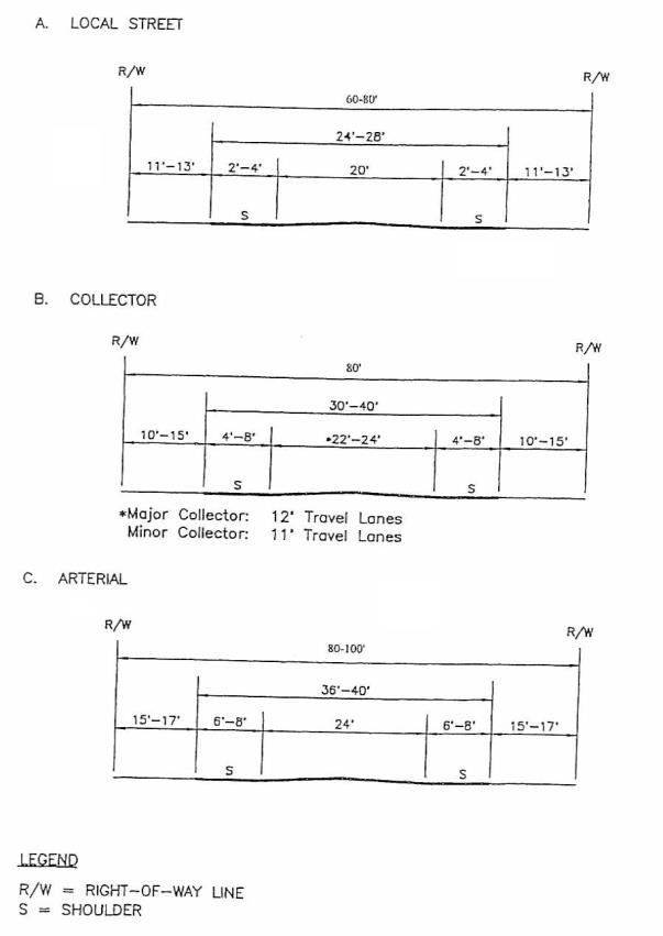
Exhibit D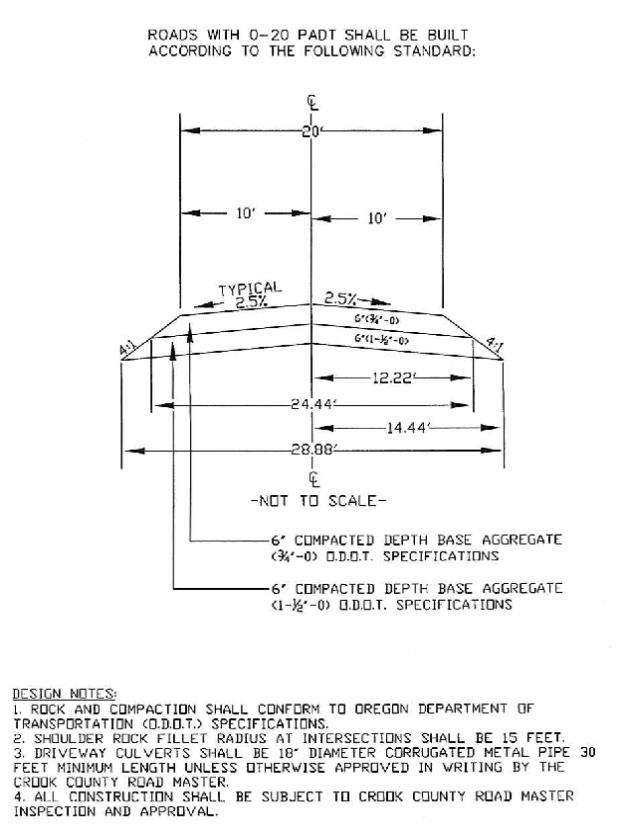
(Ord. 303 § 1 (Exh. C), 2017; Ord. 231 § 1 (Exh. A), 2010; Ord. 194 §§ 4, 5, 6, 2008; Ord. 149 Amd. 1 §§ 18 – 24, 2006; Ord. 19 § 8.030, 2003)
17.36.040 Reserve strips.
(1) Reserve Strips. Reserve strips or plugs controlling access to roads will not be approved unless deemed necessary by the commission for the protection of public safety and welfare.
(2) Alignment. All proposed roads shall be in alignment with existing streets by continuations of the center lines thereof. Offset street alignment resulting in “T” intersections shall have a minimum distance of 200 feet between the center lines of opposite streets of approximately the same direction unless prohibited by topographical features; however, in no case shall any center line offset of less than 100 feet be permitted.
(3) Future Extensions of Roads. When necessary to give access to or permit a satisfactory future division of adjoining land, roads shall be extended to the boundary of the subdivision or partition and the resulting dead end roads may be approved without a turnaround. Reserve strips and road plugs may be required to preserve the objectives of road extensions.
(4) Intersection Angles. Roads shall be laid out to intersect at angles as near to right angles as practical, except where topography requires a lesser angle. In no case shall the acute angle be less than 80 degrees unless there is a special intersection design. Sight distance requirements shall be determined by the standards contained in the most recent edition of American Association of Highway and Transportation Officials “Geometric Design of Highways and Streets.”
(5) Road Names. Except for extensions of existing roads, no road name shall be used which will duplicate or be confused with the name of an existing street in the city or county. Street names and numbers shall conform to the established pattern in the city and shall be subject to the approval of the county building department. The developer shall provide all street signs.
(6) Marginal Access Streets. Where a land division abuts or contains an existing or proposed collector or arterial road, the planning commission may require marginal access streets, reverse frontage lots with suitable depth, screen planting contained in a non-access reservation along the rear or side property line, or other treatment necessary for adequate protection of residential properties and to afford separation of through and local traffic.
(7) Alleys. Alleys shall comply with the city of Prineville standards for alleys.
(8) Access Crossing Public Lands. Where the provision of public access requires the crossing of public lands, approval shall be obtained by the developer of the subdivision from the agency having jurisdiction over said public lands crossed prior to commission approval of the preliminary plat. (Ord. 149 Amd. 1 §§ 25, 26, 2006; Ord. 19 § 8.040, 2003)
17.36.050 Maintenance of roads.
When possible, the developer of any road shall provide a method for the future maintenance of the road. Prior to approval of an EFU-2 or EFU-3 Rural Road serving more than one residence, the applicant or developer shall establish an enforceable road maintenance agreement binding on all participating parcels subject to partition by the applicant or developer and running with the land. Any approval of an EFU-2 or EFU-3 Rural Road shall contain a disclaimer that approval does not represent an opinion or determination by Crook County that any such road will provide a safe or adequate travelling surface for vehicular or other traffic and that any such road is not eligible for county maintenance. (Ord. 194 § 7, 2008; Ord. 19 § 8.050, 2003)