


Chapter 12.18
ROAD DESIGN STANDARDS
Sections:
12.18.010 Compliance required.
12.18.020 Minimum standards established.
12.18.030 Implementation of requirements.
12.18.040 Additional design requirements.
12.18.050 Approval of variations.
12.18.070 Roads within an urban growth boundary.
12.18.080 Roads within one mile of an urban growth boundary.
12.18.110 Limiting access to arterials and collectors.
12.18.120 Minimum right-of-way and roadway width.
12.18.140 County road development requirements.
12.18.150 Local access road development requirements.
12.18.160 Private road development requirements.
12.18.180 Horizontal alignment.
12.18.010 Compliance required.
A. All road design and construction taking place on or intersecting county or local access roads shall be in compliance with the design standards set forth in this chapter. All standards set forth in this chapter apply to new county roads, local access roads, private roads and driveways unless otherwise specified.
B. New roads and improvements to existing roads may be inspected by the Jefferson County public works director or county engineer for compliance with the standards set forth in this chapter.
C. All engineering and survey stamps required shall be by professionals licensed in the state of Oregon for the engineering and/or survey discipline required. (Ord. O-69-07 § 1 Exh. A (part), 2007: Ord. O-110-02 § 2 Exh. B (part), 2002)
12.18.020 Minimum standards established.
The design standards contained within this chapter are the minimum standards governing the design of roads and other transportation improvements and facilities. (Ord. O-69-07 § 1 Exh. A (part), 2007: Ord. O-110-02 § 2 Exh. B (part), 2002)
12.18.030 Implementation of requirements.
It is the duty of the public works director to implement the provisions and requirements of this chapter in such a way as to carry out its intent and purpose. (Ord. O-69-07 § 1 Exh. A (part), 2007: Ord. O-110-02 § 2 Exh. B (part), 2002)
12.18.040 Additional design requirements.
The public works director may impose additional design requirements as are reasonably necessary to protect the interests of the public. The county reserves the right under ORS 368.036(2) to set lesser standards for work done on local access roads; provided, that it is determined to be in the public interest to do so. Reconstruction to full county road standards will be required prior to consideration of acceptance of any road into the county road system. (Ord. O-69-07 § 1 Exh. A (part), 2007: Ord. O-110-02 § 2 Exh. B (part), 2002)
12.18.050 Approval of variations.
A. The public works director, after consultation with the planning director, may approve variations in the improvement standards of this chapter or allow incremental improvements when circumstances warrant, such as when a road will provide access only for undeveloped parcels in farm or forest use, or when the surrounding road system does not comply with the standards. A variation will only be approved if:
1. There is no adverse impact to the public in allowing the variations;
2. The variation promotes the intent and purposes of the standards and is in compliance with all applicable requirements of the Jefferson County zoning ordinance;
3. There are practical difficulties that will create an unreasonable construction expense. Self-imposed difficulties will not be considered; and
4. The variation will not result in the sacrifice of a significant public benefit.
B. The decision by the public works director to grant or deny a variation of the road standards may be appealed to the board of commissioners. A written appeal must be received by the board of commissioners’ office within ten (10) days of the date the public works director issues a decision on the proposed variation. (Ord. O-69-07 § 1 Exh. A (part), 2007: Ord. O-110-02 § 2 Exh. B (part), 2002)
12.18.060 Roads.
A. The location, width and grade of roads shall be considered in their relation to existing and planned roads, topographical conditions, public convenience, safety and the proposed use of land to be served by the roads. The road system shall assure an adequate traffic circulation system for all modes of transportation, including pedestrians, bicycles and automobiles, with intersection angles, grades, tangents, and curves appropriate for the traffic to be carried, considering the terrain.
B. Road development and access onto existing roads shall be in accordance with any adopted transportation system plan.
C. Adoption of a road into the county road system shall be at the discretion of the Jefferson County board of commissioners in accordance with ORS Chapter 368 and the current Jefferson County zoning ordinance. To be considered for adoption into the county road system, a road or system of roads must be contiguous with the existing county road system through connection with either an existing county or state road and comply to the satisfaction of the Jefferson County public works director, in all respects, to the design standards set forth in this chapter and the construction standards set forth in Chapter 12.20 of this code.
D. Cul-de-sac roads will not be eligible for adoption into the county road system.
E. Roads not accepted into the county road system shall be either public local access roads, or private roads in destination resorts. (Ord. O-69-07 § 1 Exh. A (part), 2007: Ord. O-110-02 § 2 Exh. B (part), 2002)
12.18.070 Roads within an urban growth boundary.
Roads within an urban growth boundary (UGB) or urban reserve shall, at the discretion of the Jefferson County director of public works, conform to the design and construction specifications of the city contained within the UGB boundary and shall be subject to review and approval of that city’s director of public works and the Jefferson County director of public works. (Ord. O-69-07 § 1 Exh. A (part), 2007: Ord. O-110-02 § 2 Exh. B (part), 2002)
12.18.080 Roads within one mile of an urban growth boundary.
At the discretion of the Jefferson County director of public works, design and construction standards and specifications for roads within one mile of a UGB may be modified to accommodate future reconstruction to city standards. Roads in zones contiguous to the UGB of Madras, Culver or Metolius may be required to be constructed in accordance with Section 12.18.070 of this chapter if, in the opinion of the director of public works, such roads would become connected to the city road system. (Ord. O-69-07 § 1 Exh. A (part), 2007: Ord. O-110-02 § 2 Exh. B (part), 2002)
12.18.090 Existing roads.
Whenever existing roads, adjacent to or within a tract, are of inadequate width to accommodate the increase in traffic expected from any proposed development, additional rights-of-way to meet current standards may be required. Improvements to adjacent roads and intersections may be required if road capacity, traffic flow, public safety, or the road surface will be directly affected by traffic that will be generated by the proposed development. Any requirement for road improvements or dedication of additional right-of-way will be based on a direct nexus between the level of road impacts that will be caused by the development and the level of road improvements that are required. (Ord. O-69-07 § 1 Exh. A (part), 2007: Ord. O-110-02 § 2 Exh. B (part), 2002)
12.18.100 Continuation roads.
A new road which will constitute the continuation of an existing road shall be aligned so that the centerlines of the new and existing roads coincide. Where a straight-line continuation is not possible, the centerline shall be continued by a curve. (Ord. O-69-07 § 1 Exh. A (part), 2007: Ord. O-110-02 § 2 Exh. B (part), 2002)
12.18.110 Limiting access to arterials and collectors.
When an application is submitted to develop or divide a parcel that abuts or contains an existing or proposed collector or arterial road, the county may limit access to the arterial or collector by requiring frontage roads, reverse frontage lots, a nonaccess reservation along the property line adjacent to the arterial or collector, or other means of preventing or limiting the number of access points onto the arterial or collector. (Ord. O-69-07 § 1 Exh. A (part), 2007: Ord. O-110-02 § 2 Exh. B (part), 2002)
12.18.120 Minimum right-of-way and roadway width.
The road right-of-way and roadway surfacing width shall be in conformance with Table A, Minimum Road Design Standards, or as otherwise specified in this chapter. Additional right-of-way for construction of drainage easements may be required if necessary to contain the limits of cuts, fills and structural improvements. (Ord. O-69-07 § 1 Exh. A (part), 2007: Ord. O-110-02 § 2 Exh. B (part), 2002)
12.18.130 Road design.
A. Roads shall be designed by a registered professional engineer and shall at a minimum conform to the design standards set forth in Table A, Minimum Road Design Standards, and this chapter, and shall otherwise conform to American Association of State Highway and Transportation Officials (AASHTO) standards. Base rock and pavement dimensions set forth in Table A may be increased by the director of public works if necessitated by anticipated traffic volumes or geotechnical considerations. The public works director may allow lesser structural sections if the developer provides a twenty-five (25) year minimum life design meeting AASHTO or ODOT criteria, developed and stamped by a licensed professional engineer. Such design must be based on geotechnical testing on site and use traffic loads consistent with the ultimate development of the road system. The adequacy of existing structural sections and the required structural modifications to the existing structural section(s) required to meet a twenty-five (25) year design life for the ultimate traffic load shall be in accordance with the current edition of the Asphalt Institute Manual.
B. The design of bridges included in the alignment of a road shall be prepared by a registered professional structural engineer and shall at a minimum include a traveled way six feet wider than the road served by the bridge, support a HS2O wheel loading and conform in all other respects to the design standards and specifications for new bridges in the current ODOT design standards. Pedestrian bridges shall have a maximum width of five feet and be designed by a registered professional structural engineer to meet current live and dead load standards for the use proposed. The public works director may impose additional criteria if necessary to accommodate emergency vehicle access, future capacity or other design considerations.
C. Cuts or fills in excess of four feet and steeper than two to one slope shall require either a geotechnical report by a registered professional engineer indicating adequate slope stability for the material involved or a retaining structure design prepared by a registered professional engineer to current standards for the materials and methods proposed.
D. All designs prepared in relation to the requirements of this section are subject to the review and approval of the public works director. (Ord. O-69-07 § 1 Exh. A (part), 2007: Ord. O-110-02 § 2 Exh. B (part), 2002)
12.18.140 County road development requirements.
A. Construction standards for roads that the Jefferson County board of commissioners has agreed to accept into the county road system will be based on the functional classification of the road. New county roads shall comply with the construction standards set forth in Table A, Minimum Road Design Standards and this Chapter 12.18, unless the developer submits a design report prepared by a registered engineer proposing alternative specifications that the engineer certifies are equivalent or superior to these standards, and the public works director concurs.
B. Minimum tangent and minimum curve radius shall be in accordance with AASHTO design standards.
C. Additional, higher standards may be required by the public works director when necessary to address heavy traffic demands, geotechnical considerations, environmental requirements or other factors. (Ord. O-69-07 § 1 Exh. A (part), 2007: Ord. O-110-02 § 2 Exh. B (part), 2002)
12.18.150 Local access road development requirements.
A local access road is a public road that is not a county road, city street, state highway or federal road. New local access roads shall be dedicated to the public, but shall be constructed and maintained by private parties. Development of a new local access road, including surveying, recording of dedication documents, construction, placement of signs, and ongoing maintenance are the responsibility of the developer or abutting property owners. County funds may be expended for repair of existing local access roads only in limited emergency circumstances. The county and its officers and employees shall not be liable for failure to improve or repair a local access road.
A. Construction standards for local access roads are the same as the standards for county roads in Section 12.18.140 and Table A, Minimum Road Design Standards.
B. Turnarounds shall be provided every one-half mile on dead-end roads that are more than one mile in length.
C. An Oregon registered professional engineer or engineering geologist shall provide documentation and shall certify that the road was constructed in compliance with the standards in this Chapter 12.18 and the road improvement plans approved by the public works director. (Ord. O-69-07 § 1 Exh. A (part), 2007: Ord. O-110-02 § 2 Exh. B (part), 2002)
12.18.160 Private road development requirements.
Private roads are allowed only in destination resorts. No county funds will be expended for development, construction or maintenance of a private road, nor will the county or any of its officers or employees be liable for failure to improve or repair a private road.
A. Private roads shall be constructed to meet the standards for county roads in Section 12.18.140 of this chapter and Table A, Minimum Road Design Standards.
B. An Oregon registered professional engineer or engineering geologist shall provide documentation and shall certify that the road was constructed in compliance with the standards specified in this Chapter 12.18 and the road improvement plans approved by the public works director.
C. Private roads may be gated, provided the gate is a minimum of twenty (20) feet wide and is constructed in a manner that will allow manual operation by one person. Gates shall not be locked unless equipped with a Knox box purchased from the fire district with keys provided to all emergency service providers. (Ord. O-69-07 § 1 Exh. A (part), 2007: Ord. O-110-02 § 2 Exh. B (part), 2002)
12.18.170 Improvement plans.
A. Copies of the improvement plans for new or reconstructed roads shall be submitted to the public works department for review. Construction of the road shall not commence until the plans have been approved by the public works director.
B. A complete final set of certified Mylar improvement plans and current AutoCAD drawing (.dwg) computer file or other media acceptable to the county engineer shall be approved by the public works director prior to the start of construction or improvement to any road. The improvement plans and .dwg file shall become the property of the county and will remain at the community development and public works departments.
C. Each sheet shall be drafted in permanent ink on twenty-four (24) by thirty-six (36) inch Mylar, bear the stamp and signature of the registered engineer, include a title block which shall be located on the bottom edge or at the lower right-hand corner of the sheet and, unless approved by the public works director prior to beginning work:
1. Sheet one shall be a cover sheet and shall include:
a. Project title;
b. Location map;
c. Vicinity map;
d. Legend;
e. Signature box with spaces provided for county approval and for approval by all affected cities, utility companies and irrigation districts; and
f. Plan sets including five or more sheets shall include an index on the cover sheet.
2. Line types for existing items shown on the plans shall be dashed lines 0.3 mm in width or less. Line types for design items shall be solid lines 0.5 mm or heavier. Road centerlines shall be standard long and short dash line type, 0.7 mm in width.
3. All plan views and maps shall include a clearly marked north arrow.
4. Scales shall be clearly indicated in the title block of each sheet. Detail drawings which are drawn at a scale other than the scale indicated on the sheet shall have the detail title and scale as indicated below:
(DRAWING)
Title of Drawing
Scale 1" = x'
5. Unless approved by the public works director, details, typical sections, materials tables and similar detail drawings shall be drafted on a sheet separate from the title or plan and profile sheets.
6. Plan and profile sheets shall be split horizontally at the midpoint of the usable area outside the title block. Plan view scale shall be fifty (50) feet to the inch; profile view shall be fifty (50) feet to the inch horizontal scale and five feet to the inch vertical scale.
7. Plan views shall show:
a. Centerline alignment showing point of curvature and point of tangency station, delta, radius, arc length and short tangent for all curves and bearing and distance of all tangents;
b. Dimensioning necessary to survey and relocate the roadway;
c. Dimensioned right-of-way lines as shown on the final plat;
d. Location and description of monuments found or set on the right-of-way line;
e. Existing easement and recording references;
f. Type, location and size of all existing and proposed drainage and irrigation structures; and
g. Location and type of all existing and proposed signs and barricades.
8. Profile views shall show:
a. Centerline grades and vertical curves, complete with point of intersection elevation and stationing, length of vertical curves and percent grade of vertical tangents;
b. Original ground at centerline extending five hundred (500) feet past the construction limits and original ground at ditch lines if a significant traverse slope exists;
c. Curb profiles, where curbs are required;
d. Super-elevation transition diagrams for horizontal curves if curbs are not required; and
e. Type, location, size, flow and finished grade elevations of all existing and proposed drainage, irrigation structures and utilities within the right-of-way.
9. Structural section sheets shall include but not be limited to:
a. Width, depth and type of base layer(s);
b. Width, depth and type of paving;
c. Curbs, if required;
d. Side slopes;
e. Ditch section;
f. Crown slope; and
g. Utilities.
10. Structural and detail plans of all structures, including, but not limited to, bridges, drainage structures, irrigation structures and sewer lines, stamped by a registered engineer.
11. The developer shall submit, with his proposed improvement plans, an itemized construction cost estimate. This estimate shall include all related roadwork and affected utility installation and/or related relocation.
12. The developer shall submit a traffic control, permanent sign and stripping plan (including all required traffic control signs and road name signs) in accordance with the current edition of MUTCD.
13. Any other information required by the public works director, planning director, county engineer, or hearings body. (Ord. O-69-07 § 1 Exh. A (part), 2007: Ord. O-110-02 § 2 Exh. B (part), 2002)
12.18.180 Horizontal alignment.
A. Horizontal curve and tangent design elements shall meet or exceed minimum standards of the current AASHTO specifications.
B. The centerline of road improvements shall coincide with the centerline of the right-of-way unless an eccentric right-of-way is required to contain the limits of cuts and fills.
C. Super-elevation shall be designed in accordance with current AASHTO specifications with the maximum super-elevation being six percent. (Ord. O-69-07 § 1 Exh. A (part), 2007: Ord. O-110-02 § 2 Exh. B (part), 2002)
12.18.190 Vertical alignment.
A. Vertical curves shall be designed to be consistent with and complimentary to the horizontal curves. Vertical curves shall be designed in accordance with current AASHTO standards.
B. Maximum percent of grade shall be as shown in Table A, Minimum Road Design Standards. Minimum grade shall be one percent for all roads, unless a drainage plan is submitted to and approved by the public works director.
C. Angle points shall not be allowed on grade breaks over one percent. (Ord. O-69-07 § 1 Exh. A (part), 2007: Ord. O-110-02 § 2 Exh. B (part), 2002)
12.18.200 Intersections.
A. All intersections shall be planned for through traffic on the road with the greatest projected average daily traffic (ADT). The side road shall be at right angles (ninety (90) degrees) to the main road unless physical constraints of the site or topography require a lesser angle. In no case shall a new road enter an intersection at an angle of less than seventy-five (75) degrees. Horizontal and vertical alignment for an intersection shall be as shown in Drawing No. 2-4.3 of the Jefferson County Standard Drawings.
B. Minimum intersection spacing of new roads shall be in accordance with the access spacing distances specified in Table A, Minimum Road Design Standards. Distances shall be measured between intersection centerlines of the roads. Access to state roads and highways shall be at current ODOT standards and are subject to review and approval by ODOT.
C. Roads located on opposite sides of a through street shall either have their centerlines directly opposite each other or shall meet the minimum access spacing standards specified in Table A.
D. A roundabout may be required when the level of service (LOS) of an intersection will be less than LOS C. (Ord. O-69-07 § 1 Exh. A (part), 2007: Ord. O-110-02 § 2 Exh. B (part), 2002)
12.18.210 Drainage.
A. Minimum Requirements. Drainage facilities shall be designed and constructed to receive and transport at least a fifty (50) year storm frequency for all surface drainage water coming to and passing through the development. The public works director may require additional capacity if failure of the drainage structure would adversely impact highways, railroads, utilities, or emergency services or facilities. The system shall be designed for maximum allowable development of the drainage area served by the drainage facility.
B. Road culverts shall be corrugated metal pipe with a minimum design life of fifty (50) years. All cross culverts shall be eighteen (18) inches in diameter or larger. Where unusual site conditions warrant and a fifty (50) year storm would not cause backflooding, a twelve (12) inch diameter culvert may be approved in advance at the discretion of the public works director. Culverts shall be placed in natural drainage areas and shall provide positive drainage. Culverts installed more than ten (10) feet below road grade shall be six inches larger in diameter than otherwise required in this section.
C. Driveway culverts, where required, shall be twelve (12) inches in diameter or larger and shall be sized such that the culvert will not impede the flow of a fifty (50) year storm.
D. The grade line of ditches shall be constructed such that ditches and culverts shall share common flow lines.
E. A minimum of one foot of cover shall be required for all culverts.
F. Culverts over sixty (60) feet in length and/or having over four feet of cover shall be considered storm sewers and shall be designed and installed in accordance with ODOT storm sewer standards.
G. Drainage Plans. A complete set of drainage plans, stamped by a licensed engineer, including hydraulic and hydrologic calculations, shall be incorporated in all road improvement plans.
H. Culverts shall be installed in accordance with ODOT standard specifications.
I. Bridges will be designed by a registered professional structural engineer in accordance with current AASHTO and ODOT standards and shall include a stamped set of plans and specifications. All bridges shall be designed to receive and transport a minimum one hundred (100) year storm frequency of all drainage water coming to the structure at full development of the drainage.
J. All work shall be in accordance with an erosion control plan reviewed and approved by the Oregon Department of Environmental Quality prior to beginning work. (Ord. O-69-07 § 1 Exh. A (part), 2007: Ord. O-110-02 § 2 Exh. B (part), 2002)
12.18.220 Driveways.
A. Permit Required. Access or change in type of access onto a county or local access road shall require a permit from the community development department. Access roads shall conform to this code and current Oregon Fire Code. Access shall be denied at locations that do not meet minimum sight distance and spacing standards. Proof of legal access, provided by the owner/developer, shall be required for all parcels not fronting directly on a county or local access road.
B. Access Restrictions and Limitations. Driveway access onto arterials and collectors shall not be permitted within one hundred fifty (150) feet of an intersection, or the maximum distance obtainable on the parcel, whichever is less. Driveway access onto minor collectors or local roads shall not be permitted within one hundred (100) feet of an intersection, or the maximum distance obtainable on the parcel, whichever is less.
C. Driveways shall be spaced at least seventy-five (75) feet apart, measured from the centerline of the driveway, except at the bulb end of a cul-de-sac or when an existing lot width is less than seventy-five (75) feet. Driveway spacing shall be in accordance with applicable city standards when the lot is within an urban growth boundary. Loop driveways shall not be permitted on arterials or major collectors. Loop driveways may be permitted on minor collectors or local roads if the interval between the two access points of the loop driveway is at least seventy-five (75) feet, and both access points are at least seventy-five (75) feet from the driveways on adjacent parcels.
D. When a parcel abuts more than one road, access shall be obtained from the road with the lower functional classification unless unfeasible because of topography or other physical feature.
E. Commercial and Industrial Access. Requirements for commercial and industrial access will be determined by the public works director in accordance with Section 12.18.200 of this chapter. Safety improvements, including but not limited to left turn lanes, acceleration lanes, and traffic separation may be required.
F. Safety improvements, including but not limited to the removal of obstructions or the sloping of cut-banks within the public right-of-way of the parcel served, may be required if deemed necessary by the public works director. The public works director may require that any such improvements within the public right-of-way be done by the county public works department or a licensed contractor. All such work shall be at the sole expense of the landowner. The owner shall be required to post a bond for the cost of such work prior to the beginning of construction.
G. Sight Distance. Sight distance shall meet current AASHTO standards.
H. Access Width. The following are the surface width and grade requirements for private driveways:
|
|
Width (in feet) |
Grade % |
||
|---|---|---|---|---|
|
Type |
Min. |
Max. |
Desired |
Max. |
|
Residential |
12 |
20 |
8 |
12 |
|
Agricultural |
12 |
40 |
10 |
14 |
|
Commercial/ Industrial |
20 |
40 |
6 |
10 |
I. Driveway access to within fifty (50) feet of all buildings shall be constructed to the following standards unless a variance has been granted in accordance with Section 426.5 of the Jefferson County Zoning Ordinance:
1. Access roads and driveways serving a single residence shall have a surface width of at least twelve (12) feet. The width shall be increased to a minimum of fourteen (14) feet in curves with a centerline radius of less than one hundred fifty (150) feet to ensure emergency vehicles remain on an all-weather surface. The approach shall extend from the county access road for fifteen (15) feet with a slope not to exceed five percent in run slope and conform to cross slope of county access road. If due to topographical restrictions the five percent slope cannot be maintained the approach shall be hard surfaced with either minimum two-inch asphalt or five-inch concrete cover. The approach at the county access junction shall not be less than twenty-seven (27) feet wide and taper down to the required width based on number of residences served by driveway. If required, culverts shall be metal with minimum twelve (12) inch diameter, aligned with drainage ditch and minimum nine inches from edge of county access road. The area extending at least ten (10) feet from each side of the driveway’s centerline shall be kept clear of obstructions and shall be maintained as a fuel break. Driveways more than two hundred fifty (250) feet in length shall include turnouts at one hundred fifty (150) foot intervals or lesser distance as needed to allow visibility. Turnouts shall be at least ten (10) feet in width and fifty (50) feet in length and shall meet the same load requirements as required by subsection (I)(5) of this section.
2. Access roads and driveways serving more than one residence shall have a surface width of at least twenty (20) feet.
3. Commercial or industrial buildings that will have any portion of an exterior wall more than one hundred fifty (150) feet from an existing road shall have an emergency vehicle access drive with a surface width of at least twenty (20) feet.
4. A minimum clear height of at least fourteen and one-half (14-1/2) feet shall be maintained for the entire width of the driveway.
5. Access shall be designed and constructed to maintain a minimum seventy-five thousand (75,000) pound load carrying capacity. If not designed by an engineer, driveways shall be constructed of a minimum of five compacted inches of crushed rock meeting ODOT material standards. The road shall be compacted until a loaded ten (10) cubic yard dump truck ceases to deflect the road.
6. Maximum finished grade shall be no greater than ten (10) percent unless approved by the fire chief. Grade shall not exceed four percent in turnarounds. Any portion of the access with a grade greater than eight percent shall be surfaced with one-and-one-half-inch class C asphalt mix, 0-11 oil mat, or four-inch fiber mesh reinforced Portland cement concrete.
7. Curves shall have a minimum centerline radius of fifty-five (55) feet, including the intersection of a driveway with a public road.
8. Gates shall be a minimum of twenty (20) feet wide, and shall be of a swinging or sliding type constructed of materials that allow manual operation by one person. Electric gates shall be equipped with a Knox box purchased from the fire district.
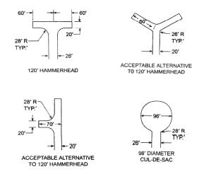
9. Dead-end access roads and driveways more than one hundred fifty (150) feet in length shall terminate in a one hundred twenty (120) foot hammerhead, sixty (60) foot “Y” or ninety-six (96) foot diameter cul-de-sac or alternative turnaround arrangement as shown in the following diagrams. Turnarounds shall also be provided every one-half mile on dead-end access roads and driveways exceeding one mile in length. The turnaround area shall meet the same load requirements as required by subsection (I)(5) of this section.
J. Driveways shall be constructed in such a manner that water, aggregate or any other substance that is hazardous to the traveling public will not enter onto the public roadway from the driveway.
K. Driveway entrances shall be shaped to not impede stormwater runoff from the surface of the public road into the drainage system.
L. Drainage shall conform to the requirements of Section 12.18.210 of this chapter.
M. Where a drainage structure larger than five feet in diameter is required, specific design and installation shall be developed by a licensed engineer and submitted to the public works director for approval prior to approval of the access. (Ord. O-82-19 § A, 2019; Ord. O-69-07 § 1 Exh. A (part), 2007: Ord. O-110-02 § 2 Exh. B (part), 2002. Formerly 12.18.230)
12.18.230 Sidewalks.
Sidewalks or walkways shall be included as part of the development of a new road when required by an adopted transportation system plan, the Jefferson County zoning ordinance, or by city standards when the property is in an urban growth boundary. Sidewalks, crosswalks, islands, curb cuts, and sidewalks at driveway crossings shall be constructed to the standards outlined in the most current edition of the Oregon Bicycle and Pedestrian Plan adopted by the Oregon Transportation Commission. (Ord. O-69-07 § 1 Exh. A (part), 2007)
12.18.240 Bicycle facilities.
Paved shoulders designed for use as bicycle facilities shall be provided as part of the construction or reconstruction of roads. Minimum shoulder widths shall be as shown in Table A. As an alternative, a multi-use path designed for use by bicycles and pedestrians within a right-of-way separate from the road may be provided when approved by the public works director and planning director. Bicycle facilities shall be constructed to the standards outlined in the most current edition of the Oregon Bicycle and Pedestrian Plan adopted by the Oregon Transportation Commission. (Ord. O-69-07 § 1 Exh. A (part), 2007)
Table A
|
|
Principal Arterial |
Minor Arterial |
Major Collector |
Minor Collector |
Local Road |
|||||
|---|---|---|---|---|---|---|---|---|---|---|
|
High Volume |
Low Volume |
High Volume |
Low Volume |
Industrial6 |
High Volume |
Low Volume |
Industrial6 |
|||
|
Typical ADT (Average Daily Traffic) |
>7,500 |
5,500 – 7,500 |
4,000 – 6,000 |
2,500 – 4,000 |
1,200 – 2,500 |
600 – 1,200 |
500 – 1,000 |
150 – 600 |
0 – 150 |
100 – 500 |
|
Minimum Right-of-Way Width |
5 |
80 ft. |
72 – 80 ft. |
72 ft. |
72 ft. |
60 ft. |
60 ft. |
50 ft. |
50 ft. |
72 ft. |
|
Lane Width -Minimum 1 -Recommended |
|
12 ft. 12 ft. |
12 ft. 12 ft. |
12 ft. 12 ft. |
11 ft. 12 ft. |
11 ft. 12 ft. |
14 ft. 14 ft. |
11 ft. 12 ft. |
10 ft. 12 ft. |
14 ft. 14 ft. |
|
Shoulder Width -Minimum 1 -Recommended |
6 ft. 8 ft. |
6 ft. |
5 ft. 6 ft. |
4 ft. 6 ft. |
4 ft. |
8 ft. |
3 ft. |
3 ft. |
8 ft. |
|
|
Shoulder Surface |
A.C. |
A.C. |
A.C. |
A.C. |
A.C. |
A.C. |
A.C. |
A.C |
A.C. |
|
|
Pavement Width 2 |
40 ft. |
36 ft. |
36 ft. |
36 ft. |
32 ft. |
44 ft. |
30 ft. |
30 ft. |
44 ft. |
|
|
Minimum Access Spacing |
1,320 ft. |
500 ft. |
500 ft. |
300 ft. |
300 ft. |
300 ft. |
100 ft. |
100ft. |
100 ft. |
|
|
Surface Type |
4" A.C. |
4" A.C. |
4" A.C. |
4" A.C. |
2" A.C. |
4" A.C. |
2" A.C. |
2" A.C. |
4" A.C. |
|
|
Base Depth |
10" |
10" |
10" |
8" |
10" |
10" |
8" |
8" |
10" |
|
|
Maximum Grade |
8%3 |
8%3 |
8%3 |
8%3 |
8%3 |
6%3 |
10%3 |
10%3 |
6%3 |
|
|
Applicable Specifications |
4 |
4 |
4 |
4 |
4 |
4 |
4 |
4 |
4 |
|
NOTES:
• Whenever any road is created or upgraded within either the UGB or one mile of any incorporated city, the road may be required to be constructed to city standards.
• In unincorporated areas, the county engineer may recommend city of Madras urban road standards, if deemed appropriate.
1 Design for recommended standard unless approved by the public works director.
2 Pavement width depends on lane and shoulder widths. Turning lanes, when required, will add additional width.
3 Grade shall not exceed four percent in turnarounds and within twenty (20) feet of an intersection with a higher classification road.
4 Oregon Department of Transportation “Standard Specifications for Highway Construction” and the “Special Provisions” applicable to the project.
5 Principal arterial roads should meet standards for the corresponding functional classification provided in OAR 734.051 and the Oregon Highway Plan.
6 Industrial road design standards are only applicable in industrial or commercial zones.
(Ord. O-69-07 § 1 Exh. A (part), 2007)