


Chapter 2.5
FLOODPLAIN OVERLAY DISTRICT
Sections:
2.5.110 Development to which these regulations apply.
2.5.120 Lands to which these regulations apply.
2.5.150 State and federal approval.
2.5.160 Floodway restrictions.
2.5.170 Alteration of the flood carrying capacity of a watercourse prohibited.
2.5.180 General information requirements.
2.5.190 Land division and planned development standards.
2.5.200 Manufactured home parks.
2.5.230 Flood hazard reduction standards.
2.5.250 Recreation vehicles in floodplain districts.
2.5.260 Warning and disclaimer of liability.
2.5.270 Storage of material and equipment.
2.5.100 Purpose.
It is the purpose of these regulations to promote the public health, safety and general welfare, and to minimize public and private losses due to flood conditions in specific areas. (Ord. 08-06 § 3, 2008)
2.5.110 Development to which these regulations apply.
“Development,” as defined in Chapter 1.5 SDC, includes, but is not limited to, residential and nonresidential construction, manufactured housing, and land divisions. Excavation and fill (grading) is specifically excluded from the definition of development as used in this section. Grading is regulated by SDC 2.6.180. (Ord. 08-06 § 3, 2008)
2.5.120 Lands to which these regulations apply.
These regulations shall apply to all areas within the city of Silverton that are subject to inundation from a 100-year flood. These areas are depicted on federal flood insurance rate maps (FIRMs) and floodway maps by the letters A, AE, or AO.
These areas have been identified by the Federal Emergency Management Agency (FEMA) in the flood insurance study for Marion County dated January 19, 2000 (Panels 243, 244, 382, and 400 of 1150). In addition, the city council may adopt by resolution more current studies or boundary information approved by the Federal Emergency Management Agency (FEMA).
Precise floodplain district boundaries may be difficult to determine from the maps referred to above due to their large scale and lack of site-specific studies. In such instances, the community development director may apply FEMA base flood elevations to topographic maps or site surveys in order to determine actual boundaries. In the absence of FEMA base flood elevations, the director shall reasonably utilize other sources of floodplain and floodway data to determine base flood elevations and boundaries. However, when elevation data is not available through FEMA or another authoritative source and the development consists of four or more lots, four or more structures, or four or more acres, the applicant shall generate and have certified by a registered engineer the base flood elevation. Any decision of the community development director regarding a determination of a base flood elevation or interpretation of a district boundary may be appealed in accordance with Chapter 4.8 SDC.
The flood insurance study and FIRM panels for the city of Silverton are maintained in the community development office. The community development office also maintains for public inspection all records pertaining to the provisions of this title, including elevation and flood-proofing certificates. (Ord. 08-06 § 3, 2008)
2.5.130 Floodplain variances.
Variances from the terms of this chapter shall be granted only when, because of special circumstances applicable to the property including size, shape, topography, location or surroundings, the strict application of this section deprives such property of privileges enjoyed by other property in vicinity and under identical zoning classifications. There will be no variance given to the standards for development in the floodway. Variances from the floodplain management regulations of this chapter shall be reviewed as a Type II procedure and shall be approved if the review body finds that all of the following criteria have been met:
A. The applicant can show good and sufficient cause; and
B. Failure to grant the variance would result in exceptional, nonfinancial hardship to the applicant; and
C. Issuance of the variance will not result in increased flood heights, additional threats to public safety, extraordinary public expense, create nuisances, cause fraud on or victimization of the public, or conflict with existing local laws or ordinances; and
D. The variance is the minimum necessary, considering the flood hazard, to afford relief; and in addition, variances from the required lowest floor elevation may be granted if the review body finds that the request meets the following criterion as well as those criteria listed above:
1. The parcel is one-half acre or less in size contiguous to and surrounded by lots with existing structures constructed below the base flood level.
Upon issuance of the variance, the community development director will notify the applicant in writing that the issuance of a variance to construct a structure below the base flood level will result in increased premium rates for flood insurance, and such construction below the base flood level increases risks to life and property. (Ord. 08-06 § 3, 2008)
2.5.140 Definitions.
As used in this chapter the following words and phrases shall have the following meanings:
“Base flood” or “100-year flood” means the flood having a one percent chance of being equaled or exceeded in any given year. Map designation always includes the letter “A” (e.g., A, AE, AO).
“Federal Emergency Management Agency (FEMA)” means the federal agency charged with implementing the National Flood Insurance Program. FEMA provides floodplain maps to the city of Silverton.
“Flood” means a general and temporary condition of partial or complete inundation of normally dry land areas from:
1. The overflow of inland or tidal waters; and/or
2. The unusual and rapid accumulation of runoff of surface waters from any source.
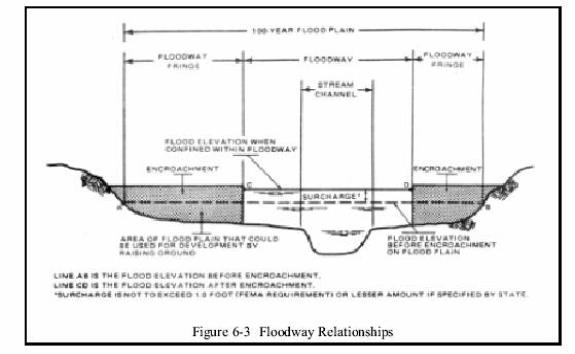
“Flood fringe” means those areas outside the floodway but within the 100-year floodplain. Zone designations on flood insurance rate maps include A, AE, and AO. Note floodway relationships diagram Figure 6-3 at the end of this section.
“Flood insurance rate map (FIRM)” means the official map on which FEMA has delineated both the areas of special flood hazards and the insurance risk premium zones.
“Floodplain” means the combined area of the floodway and the flood fringe.
“Floodproofing” means any combination of structural or nonstructural provisions, changes or adjustments to structures, land or waterway for the reduction or elimination of flood damage to real estate or improved real property, water and sanitary facilities, structures, and their contents during a 100-year flood.
“Floodway” means the channel of a river or other watercourse and the adjacent land areas that must be reserved in order to discharge the base flood without increasing the water surface elevation more than one foot. These areas are identified on the floodway maps issued by FEMA. Note floodway relationships diagram in Figure 6-3 at the end of this section.
“Lowest floor” means the lowest floor of the lowest enclosed habitable area (including basement). An unfinished or flood-resistant enclosure, usable solely for parking vehicles, building access or storage, in any area other than a basement area, is not considered a building’s lowest floor; provided, that such enclosure is not built so as to render the structure in violation of the applicable design requirements of this title found in SDC 2.5.210.
“Permanent foundation” means a natural or manufactured support system to which a structure is anchored or attached. A permanent foundation is capable of resisting flood forces and may include posts, piles, poured concrete or reinforced block walls, properly compacted fill, or other systems of comparable flood resistance and strength.
“Special flood hazard area” means areas subject to inundation during the occurrence of the 100-year flood.
“Substantial damage” means damage of any origin sustained by a structure whereby the cost of restoring the structure to its before-damaged condition would equal or exceed 50 percent of the market value of the structure before the damage occurred.
“Substantial improvement” means, for the purposes of this section, and notwithstanding the provisions for nonconforming uses and development pursuant to Chapter 5.2 SDC, any repair, reconstruction, or improvement of a structure, the cost of which equals or exceeds 50 percent of the market value of the structure before the start of construction of the improvement. This term includes structures which have incurred “substantial damage,” regardless of the actual repair work performed. The term does not, however, include either:
1. Any project for improvement of a structure to correct existing violations of state or local health, sanitary, or safety code specifications which have been identified by the local code enforcement official and which are the minimum necessary to assure safe living conditions; or
2. Any alteration of a structure identified on the city’s adopted historic inventory; provided, that the alteration will not preclude the structure’s continued designation as a historic structure.
“Watercourse” means any natural or artificial stream, river, creek, ditch, channel, canal, conduit, culvert, drain, waterway, gully, ravine or wash in which water flows in a definite direction or course, either continuously or intermittently, and has a definite channel, bed and banks, and includes any area adjacent thereto subject to inundation by reason of overflow or flood water.
(Ord. 08-06 § 3, 2008)
2.5.150 State and federal approval.
City approval of any development within the floodplain is conditioned upon receipt of any required state or federal permits. Required state and federal permits include but are not limited to:
A. Permits and associated wetland development regulations administered by the Oregon Department of State Lands.
B. Permits administered by the U.S. Army Corps of Engineers.
C. All discharge permits covered by the U.S. Environmental Protection Agency and Oregon Department of Environmental Quality. (Ord. 08-06 § 3, 2008)
2.5.160 Floodway restrictions.
No development is allowed in any floodway except where the review body finds that the development will not result in any increase in flood levels during the occurrence of the 100-year flood. Such finding shall be based upon applicant-supplied evidence certified by a registered professional engineer and upon documentation that one of the following three criteria has been met:
A. The development does not involve the construction of permanent or habitable structures.
B. The development is a public or private park or recreational use or municipal utility use.
C. The development is a water-dependent structure such as a dock, pier, bridge, or floating marina.
If a floodway boundary is not designated on an official FEMA map available to the city, the floodway boundary can be estimated from available data. Proposed development along such estimated floodway boundary shall not result in an increase of the base flood level greater than one foot as certified by a registered professional engineer. (Ord. 08-06 § 3, 2008)
2.5.170 Alteration of the flood carrying capacity of a watercourse prohibited.
No development shall diminish the flood carrying capacity of a watercourse. Subject to the foregoing regulation, no person shall alter or relocate a watercourse, without submittal of a land use review application per Chapter 4.2 SDC. The city shall provide a minimum 30-day prior written notice to any adjacent community, and the Natural Hazards Mitigation Office of the Department of Land Conservation and Development. Maintenance of the altered watercourse shall be provided so that the flood carrying capacity is not diminished over time. (Ord. 08-06 § 3, 2008)
2.5.180 General information requirements.
In addition to the information required in other sections of this code, the application for any development proposed in the floodplain district must include the following information:
A. Elevations of the original contours.
B. Final elevations of proposed fills and excavations.
C. Base flood (100-year flood) elevations of the site.
D. Location of any designated floodway and base flood boundary.
E. Location of any designated wetlands and/or wildlife habitat (if applicable).
F. Proposed elevation in relation to mean sea level of the lowest floor (including basement) of all structures (if applicable).
G. Which watercourse will be altered or relocated as a result of proposed development (if applicable).
H. If floodproofing is required, the proposed description and elevation of floodproofing. (Ord. 08-06 § 3, 2008)
2.5.190 Land division and planned development standards.
Land divisions and planned developments in the floodplain district shall be reviewed by the planning commission as a part of the land use planning process.
Notwithstanding other provisions of this code, all land division and planned development applications which propose actual development within a floodplain district shall be processed under the Type III process. An application to develop property which has a floodplain on it, but where no development is proposed in that floodplain, will be processed as otherwise required in this code. In the case of a land division, “no actual development” means the floodplain area has been excluded from the land division. This can be done by setting the property aside for some other purpose than later development, for example, as a public drainage right-of-way.
In addition to the general review criteria for land divisions and planned developments in Article 4, applications which propose actual development within the floodplain district shall also be subject to the following standards:
A. All land division proposals shall be consistent with the need to minimize flood damage.
B. All land division proposals shall have public utilities and facilities such as sewer, gas, electrical, and water systems located and constructed to minimize flood damage.
C. All land division proposals shall have adequate drainage provided to reduce exposure to flood damage.
D. Any lot created for development purposes must have adequate area created outside of the floodway to maintain a buildable site area meeting the minimum requirements of this code.
E. Any new public or private street providing access to a residential development shall have a roadway crown elevation not lower than one foot below the 100-year flood elevation.
F. All land divisions or planned developments in the floodplain district shall show the location of the 100-year flood contour line followed by the date the flood elevation was established. Where elevation data is not available, either through the Flood Insurance Study or from another authoritative source, and the development is four or more acres or results in four or more lots or structures, the elevation shall be determined and certified by a registered engineer. In addition, a statement located on or attached to the recorded map or plat shall read as follows:
Development of property within the 100-year floodplain as most currently established by the Federal Emergency Management Agency or city of Silverton may be restricted and subject to special regulations by the City.
(Ord. 08-06 § 3, 2008)
2.5.200 Manufactured home parks.
Manufactured home parks and manufactured home subdivisions proposed in the floodplain district shall be reviewed by the planning commission. Notwithstanding other provisions of this code, all manufactured home park and subdivision applications which propose actual development within the floodplain district shall be processed under a Type III process. An application to develop property which has a floodplain on it, but where no development is proposed in that floodplain, will be processed as otherwise required in this code. In the case of a land division, “no actual development” means the floodplain area has been excluded from the land division. This can be done by setting the property aside for some other purpose than later development, for example, as a public drainage right-of-way. In addition to the general review criteria applicable to manufactured home parks, applications which propose actual development within the floodplain district shall include an evacuation plan indicating alternate vehicular access and escape routes. In addition, the standards listed in SDC 2.5.210 also apply to the placement of manufactured homes within a floodplain. (Ord. 08-06 § 3, 2008)
2.5.210 Building standards.
Applications for building permits in the floodplain district shall be reviewed by the building official pursuant to locally adopted state building codes. In addition to building code criteria, all development in the floodplain district, except that exempted in SDC 2.5.230, shall be subject to the following building standards:
A. The lowest floor, including basement, of any proposed structure (including manufactured homes and nonresidential structures) shall be placed at least three feet above the 100-year flood as determined by the latest Federal Insurance Study.
B. All new construction and substantial improvements shall be constructed with materials and utility equipment resistant to flood damage.
C. All new construction and substantial improvements shall be constructed using methods and practices that minimize flood damage.
D. Electrical, heating, ventilation, plumbing, and air conditioning equipment and other service facilities shall be designed and/or otherwise elevated or located so as to prevent water from entering or accumulating within the components during conditions of flooding.
E. All manufactured homes shall be on an adequately anchored, permanent foundation and be anchored to prevent flotation, collapse or lateral movement, and shall be installed using methods and practices that minimize flood damage. Anchoring methods may include, but are not limited to, the use of over-the-top or frame ties to ground anchors (reference FEMA’s “Manufactured Home Installation in Flood Hazard Areas” guidebook for additional details).
F. All new construction and substantial improvements shall be anchored to prevent flotation, collapse, or lateral movement and shall be installed or constructed using materials, methods, and practices that minimize flood damage.
G. All new and replacement public water supply systems shall be designed to minimize or eliminate infiltration of flood waters into the system.
H. All new and replacement public sanitary sewer systems shall be designed to minimize or eliminate infiltration of flood waters into the system and discharges from the system into flood water. On-site waste disposal systems shall be located to avoid impairment to them or contamination from them during flooding.
I. Property owners or developers shall file with the city a certificate whose format is acceptable to FEMA. This certificate must be approved by the building official, prepared by a registered surveyor or professional engineer, architect or surveyor, and maintained for public inspection. The certificate must contain:
1. The actual elevation (in relation to mean sea level) of the lowest floor including basement;
2. The elevation of any floodproofing; and
3. Whether or not the structure contains a basement.
J. If floodproofing methods are required as per subsection (B) of this section, the property owners or developers shall file with the city certification by a registered professional engineer or architect that the floodproofing methods meet or exceed FEMA standards. (Ord. 08-06 § 3, 2008)
2.5.220 Procedure.
A registered Oregon engineer or land surveyor shall visit the site prior to construction and set a reference datum on the site to establish the 100-year base flood elevation. This elevation shall be shown on the building plans submitted to the city for review.
Upon issuance of the building permit, the owner or contractor of record shall set the top of the foundation forms so that the floor and mechanical equipment are three feet above the reference datum that was set by the engineer or surveyor.
Foundation approval to pour will not be granted until the engineer or surveyor has verified the elevation of the top of the forms. Verification shall be written and available to the inspector on site at the time of inspection. (Ord. 08-06 § 3, 2008)
2.5.230 Flood hazard reduction standards.
All flood hazard reduction measures are required, as applicable, and must be certified as required in SDC 2.5.210(I) and (J) to at least meet the following standards (these standards do not apply to structures exempted in this section):
A. All structures: fully enclosed areas below the lowest floor and lower than three feet above the 100-year flood level must meet or exceed the following minimum criteria:
1. A minimum of two openings, having a total net area of not less than one square inch for every square foot of enclosed area subject to flooding, shall be provided.
2. The bottom of all openings shall be no higher than one foot above grade.
3. Openings may be equipped with screens, louvers, or other coverings or devices; provided, that they permit the automatic entry and exit of floodwaters.
B. Nonhabitable construction meeting the certification requirements of SDC 2.5.210(I) and (J) can have the lowest floor and attendant utility and sanitary facilities located lower than one foot above the 100-year flood elevation if:
1. The structure is floodproofed so that areas lower than one foot above the 100-year flood level are watertight with walls substantially impermeable to the passage of water.
2. The structure has structural components capable of resisting hydrostatic and hydrodynamic loads and effects of buoyancy.
3. The applicant is notified that flood insurance premiums will be based on rates that are one foot below the floodproofed level.
4. The applicant files a certification by a registered professional engineer or architect that the design and methods of construction are in accordance with accepted standards of practice for meeting provisions of this section based on their development and/or review of the structural design, specifications and plans. Such certification shall be provided to the building official as set forth in SDC 2.5.210(I).
5. Nonhabitable construction that is elevated, not floodproofed, must meet the elevation standards of SDC 2.5.210 and the standards for space below the first floor as described in subsection (A) of this section. (Ord. 08-06 § 3, 2008)
2.5.240 Accessory buildings in floodplain districts that represent a minimal investment are exempt from the standards of SDC 2.5.210 and 2.5.220.
The following standards, and all other regulations that apply to development in floodplain areas, apply to those buildings. The definition of “minimal investment” for the purposes of this section is a building which costs less than $10,000 in labor and materials to construct. The value of a proposed building will be that value stated on the application for building permits.
A. Accessory structures shall not be used for human habitation.
B. Accessory structures shall be designed to have low flood damage potential.
C. Accessory structures shall be constructed and placed on the building site so as to offer the minimum resistance to the flow of floodwaters.
D. Accessory structures shall be firmly anchored to prevent flotation which may result in damage to other structures.
E. Service facilities such as electrical and heating equipment shall be elevated and floodproofed. (Ord. 08-06 § 3, 2008)
2.5.250 Recreation vehicles in floodplain districts.
Recreation vehicles placed on sites in the floodplain are required to either:
A. Meet the requirements of SDC 2.5.210, including the elevation and anchoring requirements for manufactured homes; or
B. Be on the site for fewer than 180 consecutive days; or
C. Be fully licensed and ready for highway use, on wheels or jacking systems attached to the site only by quick-disconnect-type utilities and security devices, and with no permanently attached additions. (Ord. 08-06 § 3, 2008)
2.5.260 Warning and disclaimer of liability.
The degree of flood protection required by this chapter is considered reasonable for regulatory purposes and is based on scientific and engineering considerations. Larger floods can and will occur on rare occasions. Flood heights may be increased as a result of failure of manmade structures and/or natural causes. This chapter does not imply that the land outside the area of special flood hazards or uses permitted within such areas will be free from flooding or flood damages. This chapter does not create liability on the part of the city of Silverton or any officer or employee thereof for any flood damages that result from reliance on this chapter or any administrative decision lawfully made thereunder. (Ord. 08-06 § 3, 2008)
2.5.270 Storage of material and equipment.
No storage of material or equipment is allowed within floodway areas, unless the storage can be approved upon determination that the following criteria have been satisfied:
A. Site plan approval has been received.
B. There is no storage or processing of material that is, in time of flooding, buoyant, flammable, toxic, explosive or otherwise could be injurious to human, animal, or plant life.
C. The material or equipment is not subject to major damage by floods and is firmly anchored to prevent flotation or is readily removable from the area within the time available after flood warning. (Ord. 08-06 § 3, 2008)