


Chapter 4.3 –
Land Divisions and Lot Line Adjustments
Sections:
4.3.300 Infill Development Options
4.3.500 Preliminary Plat Submittal Requirements
4.3.600 Approval Criteria for Preliminary Plat
4.3.700 Final Plat Submission Requirements and Approval Criteria
4.3.800 Performance Guarantees
4.3.1000 Replatting and Vacation of Plats
4.3.100 Purpose
The purpose of this Chapter is to:
A. Provide rules, regulations and standards governing the approval of subdivisions, partitions and lot line adjustments;
B. Carry out the City’s development pattern, as envisioned by the Comprehensive Plan;
C. Encourage efficient use of land resources, full utilization of urban services, and adequate provisions for motor vehicle, pedestrian and bicycle circulation;
D. Promote the public health, safety and general welfare through orderly and efficient urbanization;
E. Lessen or avoid traffic congestion, and secure safety from fire, flood, pollution and other dangers;
F. Provide adequate light and air, prevent overcrowding of land, and facilitate adequate provision for transportation, water supply, sewage and drainage; and
G. Encourage the conservation of energy resources.
4.3.200 General Requirements
A. Compliance with ORS Chapter 92. All subdivision and partition proposals shall be in conformance with State regulations set forth in Oregon Revised Statute (ORS) Chapter 92, Subdivisions and Partitions.
B. Need for Adequate Utilities. All lots created through land division shall be served by public utilities and facilities such as sewer, gas, electrical, and water systems.
C. Floodplain. Where land filling and/or development is allowed within or adjacent to the 100-year flood plain outside the zero-foot rise flood plain, and the Comprehensive Plan designates the subject flood plain for park, open space, or trail use, the City may require the dedication of sufficient open land area for a greenway adjoining or within the flood plain. When practicable, this area shall include portions at a suitable elevation for the construction of a pedestrian/bicycle pathway within the flood plain in accordance with the City’s adopted trails plan or pedestrian and bikeway plans, as applicable. The City shall evaluate individual development proposals and determine whether the dedication of land is justified based on the development’s impact to the park and/or trail system, consistent with the Public Works Construction Standards, latest edition.
D. Cul-de-sacs shall be “day-lighted” to provide pedestrian and bicycle access as allowed by neighboring properties as shown below. The Planning Commission, in conjunction with tentative subdivision plat applications, shall approve the design of all day-lighted cul-de-sacs (opening width, fencing, landscaping, hardscape, etc.).
Figure 4.3.200.A – Daylighted Cul-de-sacs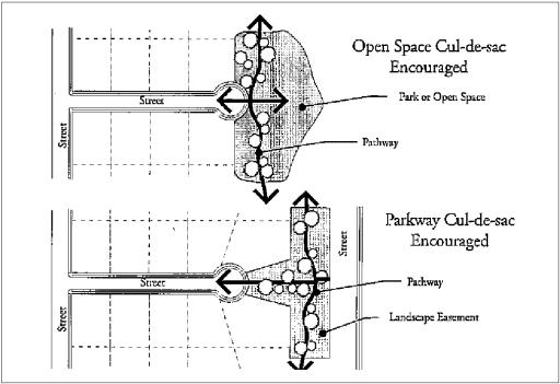
E. Easements for sewers, storm drainage and water quality facilities, water mains, electric lines or other public utilities shall be dedicated on a final plat, or provided for in the deed restrictions, prior to any connection to public infrastructure, in conformance to the Public Works Construction Standards, latest edition.
F. Public Improvements Required. Before City approval is certified on the final plat, all required public improvements shall be installed, inspected, and approved in accordance with the City’s Public Works Construction Standards, latest edition. Alternatively, the subdivider/partitioner shall provide a performance guarantee, in accordance with Section 4.3.800.
G. Underground Utilities. This standard applies only to proposed subdivisions. All utility lines including, but not limited to, those required for electric, communication, lighting and cable television services and related facilities shall be placed underground, except for surface mounted transformers, surface mounted connection boxes and meter cabinets which may be placed above ground, temporary utility service facilities during construction, and high capacity electric lines operating at 50,000 volts or above. The following additional standards apply to all new subdivisions, in order to facilitate underground placement of utilities:
1. The developer shall make all necessary arrangements with the serving utility to provide the underground services. Care shall be taken to ensure that above ground equipment does not obstruct vision clearance areas for vehicular traffic (Chapter 3.1);
2. The City reserves the right to approve the location of all surface mounted facilities;
3. All underground utilities, including sanitary sewers and storm drains installed in streets by the developer, shall be constructed prior to the surfacing of the streets; and
4. Stubs for service connections shall be long enough to avoid disturbing the street improvements when service connections are made.
5. Exception to Under-Grounding Requirement. An exception to the under-grounding requirement may be granted due to physical constraints, such as steep topography, sensitive lands or refusal by utility companies.
H. Dedication Requirements.
1. Where a proposed park, playground or other public use shown in a plan adopted by the City is located in whole or in part in a subdivision, the City shall require the dedication or reservation of this area on the final plat for the subdivision.
2. If determined by the Planning Commission to be in the public interest in accordance with adopted Comprehensive Plan policies and the City of Sisters Park Plan, and where an adopted plan of the City does not indicate proposed public use areas, the City shall require the dedication or reservation of areas within the subdivision of a character, extent and location suitable for the development of parks and other public uses.
3. All required dedications or reservations of public use areas shall conform to Section 4.3.200.K (Conditions of Development Approval).
I. Acquisition by Public Agency. If the developer is required to reserve land area for a publicly owned park, playground, or other public use, the land shall be acquired by the appropriate public agency within 24 months following final plat approval, at a price agreed upon prior to approval of the plat, or the reservation shall be released to the property owner.
J. System Development Charge Credit. Dedication of land to the City for public use areas shall be eligible as a credit toward any required system development charge for parks.
K. Conditions of Development Approval. No development may occur unless required public facilities are in place or are guaranteed in conformance with the provisions of this Code and the Public Works Construction Standards, latest edition. Improvements required as a condition of development approval, when not voluntarily accepted by the applicant, shall be roughly proportional to the impact of development. Findings in the development approval shall indicate how the required improvements are roughly proportional to the impact.
L. When subdividing or partitioning tracts into large lots (i.e., greater than two times the minimum lot size allowed by the underlying land use district), the lots shall be of such size, shape, and orientation as to facilitate future re-division in accordance with the requirements of the land use district and this Code.
M. Streets shall be extended to the boundary lines of the parcel or tract to be developed, when the Hearings Body determines that the extension is necessary to give street access to or permit a satisfactory future division of, adjoining land. The point where the streets temporarily end shall conform to 1-3, below.
1. These extended streets or street stubs to adjoining properties are not considered to be cul-de-sacs since they are intended to continue as through streets when the adjoining property is developed.
2. A barricade (e.g., fence, bollards, boulders or similar vehicle barrier) shall be constructed at the end of the street by the sub-divider and shall not be removed until authorized by the City or other applicable agency with jurisdiction over the street. The cost of the barricade shall be included in the street construction cost.
3. Temporary turnarounds (e.g., hammerhead or bulb-shaped configuration) shall be constructed for stub streets over 150 feet in length and in accordance to Oregon Fire Code.
N. Defensible Space Standards. Development shall comply with the applicable defensible space standards in Chapter 3.7 SDC. [Ord. 543 § 2 (Exh. Q), 2025].
4.3.300 Infill Development Options
Some lots in existing neighborhood may have standard widths but may be unusually deep compared to other lots in the area. Infill candidate areas generally consist of unused space at the back of a lot that may provide room for one or more lots for infill housing. Infill lots may be developed as “flag lots” or “driveway courts” as defined herein.
A. Flag Lots. Flag lots shall comply with the following development standards;
1. To determine if an existing lot is eligible for Flag lot development, the following criteria shall be met:
a. Minimum lot area: twice that required by the underlying zone.
b. Minimum lot width: 20 feet wider than the width required by the underlying zone.
2. Development Standards.
a. The minimum lot frontage for a flag lot shall be 20 feet. A 20-foot wide flag lot driveway pole may serve no more than two (2) parcels or lots (the front parent parcel and the flag lot) and no more than four (4) dwelling units, including accessory dwellings. A shared drive serving more than one lot shall have a reciprocal access and maintenance easement recorded for all lots.
b. A flag lot driveway shall not exceed 150 feet in length, unless Oregon Fire Code (OFC) standards are met.
c. The pole shall not be less than 20 feet wide. The pole shall be improved with a minimum 12 foot wide paved driveway.
d. No fence, structure or other obstacle shall be placed within the shared drive alignment.
e. Residential lots created as flag lots shall be subject to Floor Area Ratio (FAR) standards. For the purpose of calculating FAR the Flag Pole area of the lot shall not be counted.
f. Flag lot development shall not be permitted on collector or arterial streets.
g. The access strip shall not be included in the calculation of lot area for purposes of determining compliance with any minimum lot size provision of this Code.
h. If the flag portion is adjacent to a street, the dwelling unit shall have its primary entrance oriented to the street. If the flag portion is not adjacent to a street, the structures located on the flag portion are exempt from orientation standards.
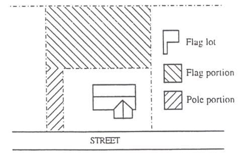
Figure 4.3.300.A – Flag Lot (Typical)
B. Driveway courts. Driveway provide access to public or private streets. Driveway courts are intended to facilitate residential infill and redevelopment of properties when no other development alternative exists. Driveway court development shall comply with the following development standards.
1. Minimum private drive aisle pavement width shall be 20 feet.
2. Pavement width shall be recorded as an easement or a tract and shall include private utility easements as needed and shall be maintained by property owners association or other legal entity.
3. Maximum length of the driveway court shall be 150 feet from the centerline of the intersecting street to the centerline of the driveway court.
4. No parking is allowed within the driveway court. “No Parking” signs shall be required and maintained.
5. A pedestrian pathway shall be provided at the “T” to connect to adjoining development.
6. Design shall be in compliance with the provisions of the Oregon Fire Code.
7. All buildings shall have their primary entrance oriented to a street where feasible.
Figure 4.3.300.B – Driveway Court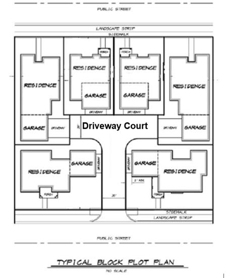
4.3.400 Approval Process
A. Subdivision and Partition Approval through Two-step Process. Applications for subdivision or partition approval shall be processed through a two-step process; the preliminary plat and the final plat.
1. The preliminary plat shall be approved before the final plat can be submitted for consideration and approval; and
2. The final plat shall include all conditions of approval of the preliminary plat.
B. Review of Preliminary Plat. Review of a preliminary plat with 2 or 3 lots (partition) shall be processed as a Type II procedure, as governed by Chapter 4.1.400. Preliminary plats with more than 3 lots (subdivision) shall be processed as a Type III procedure under 4.1.500. All preliminary plats shall be reviewed using approval criteria contained in Section 4.3.600.
C. Review of Final Plat. Review of a final plat for a subdivision or partition shall be processed as a Type I procedure under Chapter 4.1.300, using the approval criteria in Section 4.3.700.
D. Preliminary Plat Approval Period – Single Phased Development. Preliminary plat approval shall be effective for a period of two (2) years from the date the approval becomes final for single-phased land divisions. The preliminary plat approval shall lapse if a complete final plat application has not been submitted prior to the expiration date.
E. Preliminary Plat Approval Period – Multi Phased Subdivision.
1. The City, at its discretion, may approve a time schedule for developing a subdivision in phases, but in no case shall the expiration period for the initial subdivision phase be greater than two years from the date the preliminary plat approval became final or six years from the date that the preliminary plat approval became final for the final phase unless an extension is granted in accordance with SDC 4.3.400(F). The Community Development Director shall determine whether the approval, whether for the entire subdivision or any particular phase, has been initiated based on whether significant infrastructure improvements have been completed as of the date the approval expires. Such a determination will be made through either a Type II decision or, at the discretion of the Community Development Director, a Type III decision before the Planning Commission. Significant infrastructure includes but is not limited to site grading, streets, water, sewer, power and communications services construction sufficient in terms of time, labor, and/or money to demonstrate a good faith effort to complete the development or as otherwise specified as a condition of approval.
2. The criteria for approving a phased land division proposal are:
a. Public facilities shall be constructed in conjunction with or prior to each phase;
b. The development and occupancy of any phase dependent on the use of temporary public facilities shall require City Council approval. Temporary facilities shall be approved only upon City receipt of bonding or other assurances to cover the cost of required permanent public improvements, in accordance with Section 4.3.800. A temporary public facility is any facility not constructed to the applicable City or district standard;
c. The phased subdivision shall not result in requiring the City or a third party (e.g., owners of lots) to construct public facilities that were required as part of the approved preliminary plat; and
d. A request for a phased land division shall be made as part of the preliminary plat application for a phased subdivision.
F. Extensions
1. The Community Development Director may, upon written request by the applicant and payment of the required fee prior to expiration of an approval, grant a total of one extension of the approval for one year from the applicable expiration date per project; provided that:
a. The applicant can show good faith efforts have been made towards platting the applicable land division;
b. For a phased development, only a single one-year extension is permitted (not one per phase). If granted, the issuance of the extension extends the current phase and all subsequent phases by an additional year.
c. An extension of time will not prevent the lawful development of abutting properties;
d. There have been no changes to the applicable Development Code, Public Works Construction Standards, or other applicable criteria on which the approval was based. If there have been changes, then the extension will not be granted, and a new application shall be required, unless the land division can, in the discretion of the Community Development Director, be modified to comply with all current standards and the community Development Director adds conditions of approval to ensure compliance.
2. Additional Extension by Original Decision-Making Body. The original decision-making body may, upon written request by the applicant prior to the expiration of the approval period granted by the Community Development Director, grant a single additional one-year extension per SDC 4.4.300(F)(1).
3. Through the Type III application process, the Planning Commission is authorized to consider resetting the expiration date of the approval as a part of approving a major modification to an existing tentative plat. The applicant must submit justification and supporting evidence to the Planning Commission that the additional time is warranted by the proposed major modification.
G. Additional Approval Time Extension. Notwithstanding Sections D, E and F, above, all City Subdivision and Partition approvals, including approvals for which the City has granted an extension of time, that were due to expire on or after December 31, 2014, are hereby automatically and exceptionally extended to June 30, 2015. Subdivision and Partition approvals that were approved after January 1, 2015 shall comply with Sections D, E, and F, above. Approvals that have been automatically extended by this regulation may apply for an additional extension of time in accordance with Sections D, E and F above.
H. Modifications
Following partition or subdivision approval, an applicant may make modifications to the plan consistent with the following procedures. The Community Development Director or designee will determine whether the proposed modification is a minor or major modification.
1. Minor modifications are those in keeping with the general layout and pattern of the approved plan and include minor relocations of property lines, streets, walkways and alleys, changes in the site utilities, and changes which do not increase the number of lots. The Community Development Director or designee may approve a minor modification upon finding that the modification is substantially consistent with the approved tentative plan, is consistent with the provisions of this code and the conditions of approval, and does not have substantially greater impacts on surrounding properties than the original tentative plan.
2. Other modifications are major modifications. See Chapter 4.1. [Ord. 497 § 2 (Exh. B), 2019; Ord. 478 § 1 (Exh. A), 2017].
4.3.500 Preliminary Plat Submittal Requirements
A. General Submittal Requirements. The following information shall be submitted:
B. Preliminary Plat Information. In addition to the general information described in Subsection A above, the preliminary plat application shall consist of drawings and supplementary written material (i.e., on forms and/or in a written narrative) adequate to provide the following information:
1. General Information:
a. Name of subdivision (not required for partitions). This name must not duplicate the name of another subdivision in the county in which it is located (please check with County Surveyor);
b. Date, north arrow, and scale of drawing;
c. Location of the development sufficient to define its location in the city, boundaries, and a legal description of the site;
d. Names, addresses and telephone numbers of the owners, designer, and engineer or surveyor if any, and the date of the survey; and
e. Identification of the drawing as a “preliminary plat.”
2. Site analysis:
a. Streets: Location, name, present width of all streets, alleys and right-of-way on and abutting the site;
b. Easements: Width, location and purpose of all existing public and private easements of record on and abutting the site;
c. Utilities: Location and identity of all utilities on and abutting the site. If water mains and sewers are not on or abutting the site, indicate the direction and distance to the nearest one and show how utilities will be brought to standards;
d. Ground elevations shown by contour lines at 5-foot vertical intervals for ground slopes exceeding 10 percent and at 2-foot intervals for ground slopes of less than 10 percent. Such ground elevations shall be related to some established benchmark or other datum approved by the County Surveyor. This requirement may be waived for partitions when grades, on average, are less than 6 percent;
e. The location and elevation of the closest benchmark(s) within or adjacent to the site (i.e., for surveying purposes);
f. Potential natural hazard areas, including any flood plains, areas subject to high water table, landslide areas, and areas having a high erosion potential;
g. Sensitive lands, including wetland areas, streams, wildlife habitat, and other areas identified by the City or natural resource regulatory agencies as requiring protection;
h. Site features, including existing structures, pavement, large rock outcroppings, areas having unique views, and drainage ways, canals and ditches;
i. Designated historic and cultural resources on the site and adjacent parcels or lots;
j. The location, size and species of trees having a caliper (diameter) of eight inches or greater measured at four feet above grade in conformance with Chapter 3.2, and, any tree with a historic designation regardless of size;
k. North arrow, scale, name and address of owner;
l. Name and address of project designer, if applicable; and
m. Other information, as deemed appropriate by the Community Development Director or designee. The City may require studies or exhibits prepared by qualified professionals to address specific site features and code requirements.
n. A Traffic Impact Statement or Study may be required at the discretion of the Community Development Director or designee for any development that will generate less than 200 vehicle trips per day. A Traffic Impact Study shall be required for any development that generates more than 200 vehicle trips per day.
3. Proposed improvements:
a. Public and private streets, tracts, driveways, open space and park land; location, names, right-of-way dimensions, approximate radius of street curves; and approximate finished street center line grades. All streets and tracts which are being held for private use and all reservations and restrictions relating to such private tracts shall be identified;
b. Easements: location, width and purpose of all easements;
c. Lots and private tracts (e.g., private open space, common area, or street); approximate dimensions, area calculation (e.g., in square feet), and identification numbers for all lots and tracts;
d. Proposed uses of the property, including all areas proposed to be dedicated to the public or reserved as open space for the purpose of surface water management, recreation, or other use; potential location of future buildings;
e. Proposed improvements, as required by Chapter 3 (Design Standards), and timing of improvements (e.g., in the case of streets, sidewalks, street trees, utilities, etc.);
f. Preliminary location of development showing that future buildings can meet dimensional standards of base zone;
g. The proposed source and preliminary plans for domestic water;
h. The proposed method and preliminary plans of sewage disposal and method and preliminary plans of surface water drainage and treatment, if required;
i. The approximate location and identity of utilities, including the locations of street lighting fixtures;
j. Proposed railroad crossing or modifications to an existing crossing, if any, and evidence of contact with Oregon Department of Transportation related to proposed railroad crossing(s);
k. Changes to navigable streams, or other water courses. Provision or closure of public access to these areas shall be shown on the preliminary plat, as applicable;
l. Identification of the base flood elevation for development of more than 3 lots may be required at the discretion of the Community Development Director or designee. If required, written evidence of initiation of a Federal Emergency Management Agency (FEMA) flood plain map amendment shall be required when development is proposed to modify a designated 100-year flood plain. FEMA approval of the amendment may be a condition of city land use approval;
m. Evidence of written notice to the Oregon Department of Transportation (ODOT) for any development requiring access to a highway under the State’s jurisdiction; and
n. Evidence of written notice to the applicable natural resource regulatory agency(ies) for any development within or adjacent to jurisdictional wetlands and other sensitive lands.
o. Phase development plan shall include the following;
1. Overall tentative plan, including phase or unit sequence, and the schedule of initiation of improvements and projected completion date.
2. Overall facility development phasing plan, including transportation and utility facility plans that specify the traffic pattern plan for motor vehicles, bicycles and pedestrian, water systems plans, sewer system plans and utility plans.
3. Development and phasing plans for any common elements or facilities.
C. Fire Prevention Control Plan. A fire prevention control plan shall be required including the information specified in SDC 3.7.200. [Ord. 543 § 2 (Exh. Q), 2025].
4.3.600 Approval Criteria for Preliminary Plat
A. General Approval Criteria. The City may approve, approve with conditions or deny a preliminary plat based on the following approval criteria:
1. All relevant provisions of the Comprehensive Plan are met.
2. The proposed preliminary plat complies with all of the applicable Development Code sections and other applicable ordinances and regulations. At a minimum, the provisions of this Chapter, and the applicable sections of Chapter 2 (Land Use Districts) and Chapter 3 (Design Standards) shall apply;
3. The proposed plat name is not already recorded for another subdivision, and satisfies the provisions of ORS Chapter 92;
4. The proposed streets, roads, sidewalks, bicycle lanes, pathways, utilities, and surface water management facilities are laid out so as to conform or transition to the plats of subdivisions and maps of major partitions already approved for adjoining property as to width, general direction and in all other respects. All proposed public improvements and dedications are identified on the preliminary plat; and
5. All proposed private common areas and improvements (e.g., homeowner association property) are identified on the preliminary plat.
B. Housing Density. The subdivision meets the City’s housing density standards of Chapter 2.
C. Conditions of Approval. The City may attach such conditions as are necessary to carry out provisions of this Code, and other applicable ordinances and regulations, and may require reserve strips be granted to the City for the purpose of controlling access to adjoining undeveloped properties.
4.3.700 Final Plat Submission Requirements and Approval Criteria
A. Submission Requirements. Final plats shall be reviewed and approved by the City prior to recording with Deschutes County. The applicant shall submit a complete final plat application prior to the applicable expiration date of the preliminary plat approval.
B. Approval Criteria. By means of a Type I procedure, the Community Development Director shall review the final plat and shall approve or deny the final plat based on findings regarding compliance with the following criteria:
1. The final plat complies with the approved preliminary plat, and all conditions of approval have been satisfied;
2. All public improvements required by the preliminary plat have been installed and approved by the Community Development Director or designee. Alternatively, the developer has provided a performance guarantee or a cash contribution equivalent to the cost of constructing the required improvements in accordance with Section 4.3.800.
3. The streets and roads for public use are dedicated without reservation or restriction other than reversionary rights upon vacation of any such street or road and easements for public utilities;
4. The streets and roads held for private use have been approved by the City as conforming to the preliminary plat;
5. The plat contains a dedication to the public of all public improvements, including but not limited to streets, public pathways and trails, access reserve strips, parks, sewage disposal, storm drainage and water supply systems;
6. The applicant has provided copies of all recorded homeowners association Code, Covenants, and Restrictions (CC&R;s); deed restrictions; private easements and agreements (e.g., for access, common areas, parking, etc); and other recorded documents pertaining to common improvements recorded and referenced on the plat);
7. The plat complies with the applicable sections of this Code (i.e., there have been no changes in land use or development resulting in a code violation since preliminary plat approval);
8. Certification by the City or service district, as applicable, that water and sanitary sewer service is available to each and every lot depicted on the plat; or bond, contract or other assurance has been provided by the subdivider/partitioner to the City that such services will be installed in accordance with Public Works Construction Standards, latest edition, and the bond requirements of Section 4.3.800. The amount of bond, contract or other assurance by the subdivider/partitioner shall be determined by a registered professional engineer, subject to review and approval by the City;
9. The plat contains an affidavit by the surveyor who surveyed the land, represented on the plat to the effect the land was correctly surveyed and marked with proper monuments as provided by ORS Chapter 92, and indicating the initial point of the survey, and giving the dimensions and kind of such monument, and its reference to some corner established by the U.S. Geological Survey or giving two or more permanent objects for identifying its location. [Ord. 497 § 2 (Exh. B), 2019; Ord. 478 § 1 (Exh. A), 2017].
4.3.800 Performance Guarantees
A. Performance Guarantee Required. When a performance guarantee is required under Section 4.3.200(F), the subdivider/partitioner shall file an assurance of performance with the City supported by one of the following:
1. Cash deposit;
2. A surety bond executed by a surety company authorized to transact business in the State of Oregon which remains in force until the surety company is notified by the City in writing that it may be terminated; or
3. A cash contribution equivalent to the costs of constructing the required public improvements.
B. Determination of Sum. The assurance of performance shall be for a sum determined by the City as required to cover the cost of the improvements and repairs, including related engineering and incidental expenses.
C. Itemized Improvement Estimate. The developer shall furnish to the City an itemized improvement estimate, certified by a registered civil engineer, to assist the City in calculating the amount of the performance assurance.
D. Agreement. An agreement between the City and developer shall be recorded with the final plat that stipulates all of the following:
1. Specifies the period within which all required improvements and repairs shall be completed;
2. A provision that if work is not completed within the period specified, the City may complete the work and recover the full cost and expenses from the applicant;
3. Stipulates the improvement fees and deposits that are required.
4. Provides for construction of the improvements in stages and for the extension of time under specific conditions therein stated in the contract.
The agreement may be prepared by the City, or in a letter prepared by the applicant. It shall not be valid until it is signed and dated by both the applicant and authorized City representative.
E. When the Subdivider Fails to Perform. In the event the developer fails to carry out all provisions of the agreement and the City has un-reimbursed costs or expenses resulting from such failure, the City shall call in the bond or cash deposit for reimbursement.
F. Termination of Performance Guarantee. The developer shall not cause termination of nor allow expiration of the guarantee without having first secured written authorization from the City. [Ord. 478 § 1 (Exh. A), 2017].
4.3.900 Filing and Recording
A. Filing plat with County. Within 60 days of the City approval of the final plat, the applicant shall submit the final plat to Deschutes County for signatures of County officials as required by ORS Chapter 92.
B. Proof of recording. Prior to issuance of building permits for the newly-created lots, the applicant shall submit to the City a mylar copy, a paper copy, and an electronic copy of all sheets of the recorded final plat.
C. Prerequisites to recording the plat.
1. No plat shall be recorded unless all ad valorem taxes and all special assessments, fees, or other charges required by law to be placed on the tax roll have been paid in the manner provided by ORS Chapter 92.
2. No plat shall be recorded until it is approved by the County Surveyor in the manner provided by ORS Chapter 92. [Ord. 497 § 2 (Exh. B), 2019].
4.3.1000 Replatting and Vacation of Plats
A. Replatting and Vacations. Any plat or portion thereof may be replatted or vacated upon receiving an application signed by all of the owners as appearing on the deed.
B. Procedure. All applications for a replat or vacation shall be processed in accordance with the procedures and standards for a subdivision or partition (i.e., the same process used to create the plat shall be used to replat or vacate the plat). The same appeal rights provided through the subdivision and partition process shall be afforded to the plat vacation process. (See Chapter 4.1 – Types of Applications and Review Procedures).
C. Basis for denial. A replat or vacation application may be denied if it abridges or destroys any public right in any of its public uses, improvements, streets or alleys; or if it fails to meet any applicable criteria.
D. Recording of vacations. All approved plat vacations shall be recorded in accordance with 4.3.900 and the following procedures:
1. Once recorded, a replat or vacation shall operate to eliminate the force and effect of the plat prior to vacation; and
2. Vacation shall also divest all public rights in the streets, alleys and public grounds, and all dedications laid out or described on the plat.
E. After sale of lots. When lots have been sold, the plat may be vacated only in the manner herein, and provided that all of the owners of lots within the platted area consent in writing to the plat vacation.
F. Vacation of streets. All street vacations shall comply with the procedures and standards set forth in ORS Chapter 271.
G. Vacation of easements or rights-of-ways. The City may require accessways, paths or trails as a condition of the vacation of any public easement or right-of-way, in order to establish or maintain a safe, convenient, and direct pedestrian and bicycle circulation system.
4.3.1100 Lot Line Adjustments
Lot Line Adjustments include the consolidation of lots, and the modification of lot boundaries which do not result in the creation of new lots (includes consolidation of lots).
The application submission and approval process is as follows:
A. Submission Requirements. All applications for Lot Line Adjustment shall be made on forms provided by the City and shall include information required for a Type I application, as governed by Chapter 4.1.3. The application shall include a preliminary lot line map identifying all existing and proposed lot lines and dimensions; footprints and dimensions of existing structures (including accessory structures); location and dimensions of driveways and public and private streets within or abutting the subject lots; location of significant vegetation as defined and mapped in Section 3.2.500.B-C; existing fences and walls; and any other information deemed necessary by the Community Development Director or designee for ensuring compliance with City codes.
B. Approval Process
1. Decision-making process. Lot line adjustments shall be reviewed by means of a Type I procedure, as governed by Chapter 4.1.3, using approval criteria contained in subsection C, below.
2. Time limit on approval. The lot line adjustment approval shall be effective for a period of 1 year from the date of approval, during which time it must be recorded.
3. Lapsing of approval. The lot line adjustment approval shall lapse if:
a. The lot line is not recorded within the time limit in subsection 2.
b. The lot line adjustment has been improperly recorded with Deschutes County without the satisfactory completion of all conditions attached to the approval; or
c. The final recording is a departure from the approved plan.
C. Approval Criteria. The Community Development Director or designee shall approve or deny a request for a lot line adjustment in writing based on findings that all of the following criteria are satisfied:
1. No additional parcel or lot is created by the lot line adjustment, however, the number of lots or parcels may be reduced;
2. Lot standards. All lots and parcels comply with the applicable lots standards of the land use district (Chapter 2) including lot area and dimensions;
3. Access. All lots and parcels comply with the standards or requirements of Chapter 3.1 – Access and Circulation;
4. Setbacks. The resulting lots, parcels, tracts, and building locations comply with the standards of the land use district (Chapter 2);
5. Non-conforming. The resulting lots, parcels, tracts, and building locations may not create development which is non-conforming or closer to non-conformance;
6. Exemptions from Dedications and Improvements. A lot line adjustment is not considered a development action for purposes of determining whether right-of-way dedication or improvement is required.
D. Recording Lot Line Adjustments
1. Recording. Upon the City’s approval of the proposed lot line adjustment, the applicant shall record the lot line adjustment with Deschutes County within 1 year of approval (or the decision expires), and submit a copy of the recorded survey map to the City, to be filed with the approved application.
2. Time limit. The applicant shall submit a copy of the recorded lot line adjustment survey map to the City within 15 days of recording and prior to the issuance of any building permits on the re-configured lots.
E. Extension. The Community Development Director shall, upon written request by the applicant and payment of the required fee, grant an extension of the approval period not to exceed one year provided that:
1. No changes are made on the original plan as approved by the City;
2. The applicant can show intent of recording the approved partition or lot line adjustment within the one-year extension period;
3. There have been no changes in the applicable Code or plan provisions on which the approval was based. In the case where the lot line adjustment conflicts with a code change, the extension shall be denied; and
4. The extension request is made before expiration of the original approved plan.