


Division III. Generally Applicable Requirements/Standards
Chapter 16.30
GENERAL REQUIREMENTS FOR ALL SUBDIVISIONS
Sections:
16.30.010 What this chapter does.
16.30.030 Eagle Mountain City construction specifications and standards.
16.30.040 Required improvements defined.
16.30.050 Installation at developer’s expense.
16.30.070 Warranty of improvements.
16.30.080 Rural residential subdivisions.
16.30.090 Connectivity standards.
16.30.010 What this chapter does.
This chapter requires the installation, contribution and dedication, at no cost to the city, of required improvements in developments at the developer’s expense, sets improvement standards or refers to other standards, permits the phased installation of improvements, and requires the perpetual maintenance of required improvements which are not dedicated to the city. [Ord. O-06-2015 § 2 (Exh. A); Ord. O-07-2014 (Exh. A); Ord. O-07-2006 § 2 (Exh. 1 § 6.1); Ord. O-23-2005 § 3 (Exh. 1(2) § 6.1)].
16.30.020 Purpose.
The purpose of this chapter is to set forth the general requirements for all subdivisions in Eagle Mountain City. This chapter identifies required improvements, provides for a method of constructing required improvements, and provides for the construction bonding and warranty of public facilities. [Ord. O-06-2015 § 2 (Exh. A); Ord. O-07-2014 (Exh. A); Ord. O-07-2006 § 2 (Exh. 1 § 6.2); Ord. O-23-2005 § 3 (Exh. 1(2) § 6.2)].
16.30.030 Eagle Mountain City construction specifications and standards.1
The city has adopted a publication titled, “Eagle Mountain City Construction Specifications and Standards.” The provisions, standards and specifications found in this manual (and as amended in the future) are hereby incorporated herein by reference. The city engineer shall use this manual in the review of proposed construction plans for public facilities. Developers and subdividers shall also use this manual in the preparation of their construction plans. In addition, required improvements shall be installed in compliance with this title and any capital facilities plans, designs, and engineering standards separately adopted by the city or other agencies responsible for providing services to the development. [Ord. O-06-2015 § 2 (Exh. A); Ord. O-07-2014 (Exh. A); Ord. O-07-2006 § 2 (Exh. 1 § 6.3); Ord. O-23-2005 § 3 (Exh. 1(2) § 6.3)].
16.30.040 Required improvements defined.
A “required improvement” is any legal entitlement such as water rights or other legal or tangible physical improvements required for compliance with state or local statutes and ordinances. Required improvements include, but are not limited to:
A. Drainage System. A drainage system that addresses the impacts of the project on both off-site and on-site surface runoff water and that meets the requirements of Chapter 16.40 EMMC;
B. Buffers and Screens. Landscaped buffers, screening fences or walls, and similar improvements required to mitigate potential nuisances;
C. Culinary Water and Wastewater Facilities. Water and sewer mains and related improvements, water storage, lift stations, and other utilities;
D. Water Rights and Sources. Sufficient water, including sources if necessary, and water rights conveyed to the city and usable by the city for municipal purposes acceptable to the city attorney, and to meet all applicable city and other government regulatory standards for the uses proposed;
E. Off-Street Parking Areas. Off-street parking and loading areas, including any required landscaping;
F. Transportation Improvements. Roads and related improvements, including bridges, culverts, traffic control signs, and street trees (when applicable);
G. Sidewalk and Trail Systems. Sidewalks and trail systems, including signage;
H. Parks and Open Space. Parks and open space as required in the preliminary and final approval of the project, including improvements to be made on property to be owned or maintained by a homeowners’ association;
I. Restoration of Native Plants. Restoration of native plant materials and species in natural open space areas when they are disturbed (a temporary irrigation system may be required by the city engineer to stabilize plant material);
J. Utilities. Utilities such as telecommunications, electric power, natural gas, and any required conduit;
K. Street lighting;
L. Fire hydrants. [Ord. O-20-2018 § 2 (Exh. A); Ord. O-06-2015 § 2 (Exh. A); Ord. O-07-2014 (Exh. A); Ord. O-07-2006 § 2 (Exh. 1 § 6.4); Ord. O-23-2005 § 3 (Exh. 1(2) § 6.4)].
16.30.050 Installation at developer’s expense.
The installation of required improvements shall be at the developer’s expense except that the city may choose to participate in the cost of certain improvements in order to correct deficiencies in areas outside the development, or to provide capacity for future development in accordance with the capital facilities plan or general plan. Where off-site improvements, such as utility extensions, are constructed at the developer’s expense, provisions may be included in an agreement for reimbursement by landowners whose property subsequently benefits from the improvements. [Ord. O-06-2015 § 2 (Exh. A); Ord. O-07-2014 (Exh. A); Ord. O-07-2006 § 2 (Exh. 1 § 6.5); Ord. O-23-2005 § 3 (Exh. 1(2) § 6.5)].
16.30.060 Guarantees.
Completion of the improvements identified in a notice of decision and approved plans shall be guaranteed by one of the methods listed below. A separate guarantee shall be required for each phase of the development.
A. Bond. The developer may place an amount equal to 110 percent of the estimated cost of the required infrastructure improvements in escrow or improvement bond, with that amount and the accumulated interest (for a cash escrow bond) being released only after the city has inspected and accepted the required improvements. The city council may approve a phased release of portions of the funds of the bond as work proceeds, but at least 10 percent of the total shall be retained until all required improvements are installed, inspected, and accepted. If any required improvements are not completed, the city shall use as much as necessary of the escrow account or improvement bond to complete those improvements, then return any remaining balance to the developer or bonding agency.
1. Parks, Trails, and Open Space Improvements. All required parks, trails, and open space improvements in the preliminary plat or overall project are required to be improved prior to recording the first plat or a separate cash escrow of $3,750 per lot must be put in place with the city with each plat to cover the anticipated cost of park improvements. For example: final plat = 20 lots; cash escrow for final plat = $75,000 ($3,750 x 20).
B. City Attorney’s Approval. Each escrow agreement, improvement bond or other security shall be in a form approved by the city attorney.
C. Engineering Inspections. Required improvements shall be inspected by the city engineer before acceptance. Such acceptance of required improvements shall be by approval of a bond release by the city council, following submission of the developer’s written request for acceptance and receipt of the city engineer’s report that all improvements have been inspected and are in compliance with this title and EMMC Title 17. Fees for the inspection of required improvements shall be remitted prior to the recordation of any final plats or prior to the construction of any public improvements in the case of construction not related to subdivision plats.
D. Parks and Open Space Inspections. Required parks, trails, and open space improvements shall be inspected by the parks and recreation director (or designee) before acceptance. Such acceptance of these improvements shall be following submission of the developer’s written request for acceptance and the parks and recreation director’s verification that all these improvements have been inspected and are in compliance with this title and EMMC Title 17. Fees for the inspection of these improvements shall be remitted prior to the recordation of any final plats or prior to the pre-construction meeting for parks and open space, if improved prior to recording. Escrow releases shall be made a maximum of once every 30 days. Phased escrow releases as work proceeds may be made at the discretion of the parks director. After city has inspected and accepted the required improvements, city shall accept maintenance responsibility for the improvements (unless an HOA will maintain the improvements) and a 10 percent warranty amount shall be kept for one year and may be used to replace dead trees/shrubs or other failed improvements. Following the out-of-warranty inspection any remaining funds shall be released to the developer.
E. As-Built Drawings. The applicant shall pay the costs associated with the city preparing the as-built drawings of the public improvements prior to the release of any bonding amounts. [Ord. O-20-2018 § 2 (Exh. A); Ord. O-06-2015 § 2 (Exh. A); Ord. O-07-2014 (Exh. A); Ord. O-07-2006 § 2 (Exh. 1 § 6.7); Ord. O-23-2005 § 3 (Exh. 1(2) § 6.7). Formerly 16.30.070].
16.30.070 Warranty of improvements.
A. Each required improvement shall be warranted by the developer for both materials and workmanship for two years after their acceptance. Enforcement of the warranty shall be assured by one of the following:
1. Ten Percent Retention – Escrow. Retention of 10 percent of an escrow account established to comply with this title; or
2. Ten Percent Retention – New Account. Establishment of a new escrow account, in which an amount no less than 10 percent of the cost of the required improvements is deposited, and which shall be released, with accumulated interest, upon expiration of the warranty.
B. Other construction, warranty and maintenance issues include:
1. Maintenance until Final Acceptance. The developer shall be responsible for the maintenance of improvements until there has been a final acceptance of the improvement.
2. Maintenance by Homeowners’ Association. Any development that is subject to continuing maintenance requirements – such as multifamily residential developments or condominiums – shall create a homeowners’ association. The developer shall submit the proposed declaration of covenants, conditions and restrictions, condominium declarations, articles of incorporation, and bylaws for the community association for review and approval by the city attorney.
3. Maintenance as Required by Title. The maintenance of any developed and/or landscaped open space required for compliance with this title or other city ordinances shall include, but not be limited to, upkeep of landscaping, parks, trails, and fencing, where required; control of noxious weeds; litter removal; and wildfire suppression. Maintenance activities shall not diminish the protected open space values (wetlands, slopes, etc.).
4. Landscape Maintenance. Maintenance of landscaped areas includes the installation and maintenance of an irrigation system, timely irrigation, weed and pest control, and all other activities required to maintain the function of the landscaped area. Sufficient water rights for the maintenance of landscaped areas shall be dedicated to the city.
5. Two-Year Completion. Improvements must be completed within two years of recording the final plat, unless a shorter period is otherwise provided in an agreement.
6. Improvements before Building Permits. Road access must be provided as approved by the city engineer, and fire hydrants must be operational with adequate fire flow as specified in the International Fire Code before any construction within the subdivision will be allowed to proceed above foundation level. Other restrictions contained in the International Building Code or the International Residential Code may also apply.
7. Infrastructure Completed before Certificates of Occupancy. Residential occupancy of structures within a subdivision shall not be allowed until all roads are asphalted, street signs installed, utilities (except telephone) and other required public infrastructure are installed and operable (see EMMC 16.05.100(D)). The completion of required public parks may be governed by a notice of decision and shall not necessarily restrict residential occupancy. The city may allow residents to occupy a home when the weather precludes the streets from being asphalted so long as there is a guarantee that the streets will be asphalted when the weather permits.
8. Excavation Permits. Subdivisions that have received final plat approval may obtain an excavation permit to begin construction prior to recordation of final plats. [Ord. O-06-2015 § 2 (Exh. A); Ord. O-07-2014 (Exh. A); Ord. O-07-2006 § 2 (Exh. 1 § 6.8); Ord. O-23-2005 § 3 (Exh. 1(2) § 6.8). Formerly 16.30.080].
16.30.080 Rural residential subdivisions.
Subdivisions that are to be reviewed under agricultural, RA1, RA2, RD1, RD2, or FR zone development standards (see Chapters 17.20 and 17.25 EMMC) may not be required to install the same public improvements as subdivisions developed in other zones. Requirements to install curbs, gutters, sidewalks, water and sewer utilities, and street lights may be waived by the city council after a recommendation from the planning commission, upon condition that the developer provides for pedestrian circulation and accommodates water and sewer utilities and surface drainage throughout the subdivision. Necessary facilities may include, but not be limited to, trails and pathways, storm drainage detention ponds or secondary water facilities. [Ord. O-36-2020 § 2 (Exh. A); Ord. O-06-2015 § 2 (Exh. A); Ord. O-07-2014 (Exh. A); Ord. O-07-2006 § 2 (Exh. 1 § 6.9); Ord. O-23-2005 § 3 (Exh. 1(2) § 6.9). Formerly 16.30.090].
16.30.090 Connectivity standards.
These standards are intended to create a connected transportation system between neighborhoods and commercial areas, with the goal of promoting walkability through additional connections and shorter block lengths, improving emergency response times, providing better routes to schools and parks, preventing isolated developments, and reducing impacts of development on arterial and collector roads by providing alternate routes.
A. A circulation plan shall be provided as part of a preliminary subdivision plat application which shall:
1. Address street connectivity, pedestrian circulation, emergency access, and parking movements. If cut-through traffic is likely, traffic calming measures such as curb extensions, chicanes, raised crossings, or other features shall be required.
2. Show connectivity index, block length dimensions, cul-de-sac length dimensions, pedestrian facilities, and any proposed traffic calming features.
3. Plan must account for access and connectivity on adjacent parcels. On a case-by-case basis the community development director and city engineer may require changes to stub road locations if it will increase the connectivity within an adjacent property.
4. Required for any proposed residential development over one acre in size or with more than 10 units. The planning commission may waive the requirement for a circulation plan on a case-by-case basis according the following criteria:
a. Landlocked. Surrounding properties have not provided adequate stub road connections into the project.
b. A single multifamily structure (10+ units) is being constructed within an existing multifamily development.
c. The proposed development doesn’t create any new links or nodes.
B. Connectivity Index Calculation. The required connectivity index is calculated by dividing the total number of links by the total number of nodes.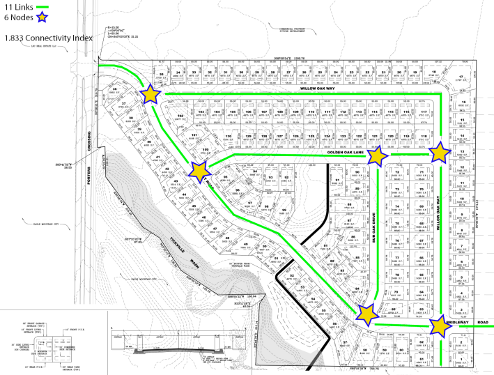
(This example shows 11 links and six nodes which equates to a connectivity index of 1.83)
1. For the purpose of calculating the number of total links, one link beyond each node shall be included in the connectivity index calculation. Street stubs that provide future access to adjacent properties or streets that connect to existing streets are considered links.
a. An additional half link shall be included in the connectivity index calculation for each hard surface pedestrian connection through a cul-de-sac with a minimum width of eight feet with an additional two-foot soft shoulder on each side.
b. An additional quarter link shall be included in the connectivity index calculation for each roadway segment where homes face an amenitized open space, park, or natural area. The roadway segment shall have a minimum 300 feet of frontage along the said open space.
C. Residential Connectivity Standards. All new residential subdivisions with 10 or more units or more than one acre shall meet the following connectivity index: block length and cul-de-sac length standards for public roads. Private roads shall be reviewed on a case-by-case basis; however, a public road may be required to prevent a private road in a subdivision from stubbing into a future or existing public road.
1. Required Connectivity Index. The minimum required connectivity index shall be required based on the project zone designation as identified in the following table of minimum connectivity index scores:
|
Zone Designation |
Minimum Index Score |
|---|---|
|
RA1 and RA2 |
1.25 |
|
RD1, RD2, FR |
1.5 |
|
R1, R2, R3 |
1.6 |
|
RC, MF1, MF2 |
1.75 |
a. Reduction in Required Connectivity Index. The required connectivity index may be reduced if the applicant provides clear and convincing evidence that it is impossible or impracticable to achieve due to the following limitations:
i. Topography;
ii. Natural features including lakes, rivers, and designated wetlands;
iii. Existing adjacent development;
iv. Rail corridors;
v. Limited access roadways.
Reductions in the required connectivity index will be reviewed on a case-by-case basis and must require recommendations from the reviewing departments and the planning commission and approval by the city council.
The total allowed reduction to the required connectivity index will be based on an analysis of existing conditions that prevent connections. As part of the analysis, city staff will ensure the internal connectivity of the subdivision meets the required connectivity index and that the connectivity is provided to adjacent properties where possible.
2. Maximum Block Lengths. Maximum block lengths allowed shall be required based on the project zone designation as identified in the following table:
|
Tier Level |
Maximum Block Length |
|---|---|
|
RA1 and RA2 |
1,200'/1,500'* |
|
RD1, RD2, FR |
1,000'/1,200'* |
|
R1, R2, R3 |
800'/1,100'* |
|
RC, MF1, MF2 |
600'/900'* |
|
* Longer block length permitted if a midblock pedestrian connection is provided. |
|
a. Increase in Block Length. The maximum allowed block length may be increased if the applicant provides clear and convincing evidence that it is impossible or impracticable to achieve due to the following limitations:
i. Topography;
ii. Natural features including lakes, rivers, and designated wetlands;
iii. Existing adjacent development;
iv. Rail corridors;
v. Limited access roadways.
Increases in block length will be reviewed on a case-by-case basis and must require recommendations from the reviewing departments and planning commission and approval by the city council.
3. Cul-de-Sac Length Standards. Maximum cul-de-sac lengths allowed shall be required based on the project zone designation as identified in the following table:
|
Tier Level |
Maximum |
|---|---|
|
RA1, RA2, RD1, RD2, FR |
400' |
|
R1, R2, R3, RC, MF1, MF2 |
250' |
a. Cul-de-sacs shall not be allowed in subdivisions zoned R1, R2, R3, RC, MF1, or MF2 unless the applicant provides clear and convincing evidence that a cul-de-sac is necessary to develop the entire parcel due to the following limitations:
i. Topography;
ii. Natural features including lakes, rivers, and designated wetlands;
iii. Existing adjacent development;
iv. Rail corridors;
v. Limited access roadways.
Requests for cul-de-sacs within subdivisions zoned R1, R2, R3, RC, MF1 and MF2 will be reviewed on a case-by-case basis and must require recommendations from the reviewing departments and planning commission and approval by the city council.
4. External Street Connectivity Standards. In addition to the internal street connectivity standards, external connectivity shall be maintained.
a. Cul-de-Sacs. In cases where cul-de-sacs have one or two rows of lots between the end of the cul-de-sac and an external road, a hard surface pedestrian connection with a minimum width of eight feet and an additional two-foot soft shoulder on each side shall be utilized to connect to the external street.
b. Pedestrian connections shall be utilized to connect proposed developments to master planned trails and adjacent existing or future developments where applicable. Connections shall be a hard surface pedestrian connection with a minimum width of eight feet and an additional two-foot soft shoulder on each side.
5. Nonresidential Connectivity Standards. All new nonresidential subdivisions containing the dedication of public roads shall meet the following connectivity index and block length standards. Private roads shall be reviewed on a case-by-case basis; however, a public road may be required to prevent a private road in a subdivision from stubbing into a future or existing public road.
a. Required Connectivity Index. The minimum required connectivity index score shall be 1.5 for nonresidential developments.
i. Reduction in Required Connectivity Index. The required connectivity index may be reduced if the applicant provides clear and convincing evidence that it is impossible or impracticable to achieve due to the following limitations:
(A) Topography:
(B) Natural features including lakes, rivers, and designated wetlands;
(C) Existing adjacent development;
(D) Rail corridors;
(E) Limited access roadways.
Reduction in the required connectivity index will be reviewed on a case-by-case basis and must require recommendations from the reviewing departments and planning commission and approval by the city council.
The total allowed reduction to the required connectivity index will be based on an analysis of existing conditions that prevent connections. As part of the analysis, city staff will ensure the internal connectivity of the subdivision meets the required connectivity index and that connectivity is provided to adjacent properties where possible.
b. Maximum Block Lengths. Maximum block lengths allowed shall be 1,000 feet for nonresidential subdivision.
i. Increase in Block Length. The maximum allowed block length may be increased if the applicant provides clear and convincing evidence that it is impossible or impracticable to achieve due to the following limitations:
(A) Topography;
(B) Natural features including lakes, rivers, and designated wetlands;
(C) Existing adjacent development;
(D) Rail corridors;
(E) Limited access roadways.
Increases in block length will be reviewed on a case-by-case basis and must require recommendations from the reviewing departments and planning commission and approval by the city council.
ii. Cul-de-Sac Standards. Cul-de-sacs shall not be allowed in any nonresidential zone unless the applicant provides clear and convincing evidence that a cul-de-sac is necessary to develop the entire parcel due to the following limitations:
(A) Topography;
(B) Natural features including lakes, rivers, and designated wetlands;
(C) Existing adjacent development;
(D) Rail corridors;
(E) Limited access roadways.
Requests for cul-de-sacs within nonresidential zones will be reviewed on a case-by-case basis and must require recommendations from the reviewing departments and planning commission and approval by the city council. [Ord. O-52-2025 § 1 (Exh. A); Ord. O-36-2020 § 2 (Exh. A); Ord. O-02-2017 § 2 (Exh. A)].
Code reviser’s note: This document is codified in EMMC Title 15.