


Chapter 16.35
DEVELOPMENT STANDARDS FOR REQUIRED PUBLIC FACILITIES
Sections:
16.35.010 What this chapter does.
16.35.030 Eagle Mountain City Construction Specifications and Standards.
16.35.050 Wastewater disposal (sewer).
16.35.070 Streets and street systems.
16.35.100 Sidewalks, trails, and pathways.
16.35.105 Park and improved open space requirements.
16.35.140 Rights-of-way profile illustrations.
16.35.150 Community mailboxes.
16.35.010 What this chapter does.
This chapter establishes development standards for all developments within Eagle Mountain City. When considering development applications, the planning director, planning commission and city council shall evaluate such applications using the provisions of this chapter. [Ord. O-27-2006 § 2 (Exh. A § 7.1); Ord. O-07-2006 § 2 (Exh. 1 § 7.1); Ord. O-23-2005 § 3 (Exh. 1(2) § 7.1)].
16.35.020 Purpose.
The purpose of this chapter is to set forth specific development standards that require all developments to install public water, wastewater, utility systems, vehicular and pedestrian circulation systems, sidewalks, trails, paths, and neighborhood and regional park facilities. [Ord. O-27-2006 § 2 (Exh. A § 7.2); Ord. O-07-2006 § 2 (Exh. 1 § 7.2); Ord. O-23-2005 § 3 (Exh. 1(2) § 7.2)].
16.35.030 Eagle Mountain City Construction Specifications and Standards.
The city has adopted a publication titled, “Eagle Mountain City Construction Specifications and Standards.” The provisions, standards and specifications found in this manual (and as amended in the future) are hereby incorporated herein by reference. The city engineer shall use this manual in the review of proposed construction plans for public facilities. Developers and subdividers shall also use this manual in the preparation of their construction plans. In addition, required improvements shall be installed in compliance with this title and any capital facilities plans, design and engineering standards separately adopted by the city or other agencies responsible for providing services to the development. [Ord. O-27-2006 § 2 (Exh. A § 7.3); Ord. O-07-2006 § 2 (Exh. 1 § 7.3); Ord. O-23-2005 § 3 (Exh. 1(2) § 7.3)].
16.35.040 Potable water.
All proposed developments shall be reviewed by the city engineer and city attorney for compliance with the drinking water source protection plan approved by the city and approved by the Utah Drinking Water Division in compliance with the Utah Safe Drinking Water Act and all applicable federal law.
A. Connection to City Water System. All permanent buildings constructed in the city intended for human occupancy or commercial use, using potable water, shall be connected to the city water system after the date of the adoption of the ordinance codified in this title, unless an existing home as of the date of enactment of the ordinance codified in this title is connected to an individual well approved by the state of Utah. An exception may be granted by the city council upon recommendation by the public works board to allow property owners to have water service by private wells when it is not feasible to connect to the city’s water system.
B. Developer’s Responsibilities. Developments shall be connected to the city’s water system at the developer’s expense. This includes water rights, costs of the service connection and meter for each lot or building, and the costs of extending mains, valves, fire hydrants, and any other improvement, including storage, pressure regulation, etc., needed to bring water service to the site. Ownership of the water system shall be dedicated to the city. Each individual property owner shall be responsible for the maintenance and operation of the individual service lateral connected to the main water line from the point of the meter to the building served by the service lateral. The city may choose to share in the costs of extending mains, constructing storage, or other improvements needed to provide capacity for future development but is not obligated to do so. Potable water service is a required improvement, subject to the provisions of this title.
C. Residential Water Rights. Table 16.35.130(a), Residential Water Right Requirements, is provided in this chapter for convenience. It defines the amount of water rights that shall be dedicated to the city for detached single-family residential uses. The engineer shall calculate water rights for other uses including commercial, multifamily residential, industrial and recreational uses after a site-specific analysis is performed for the proposed use. Water rights to service detached single-family dwellings and multifamily residential uses shall be dedicated to the city prior to the recordation of the subdivision. For developments that have filed a complete application for final plat approval prior to January 1, 2025, and do not have sufficient water banked with the city to meet the requirements of this subsection, water rights to service detached single-family dwellings and multifamily residential uses may be purchased from the city to meet the requirements of this subsection for the specific residences on the final plat to the extent that those requirements cannot be met with any water already banked with the city. Water rights to service commercial uses, industrial and recreational uses shall be dedicated to the city or sufficient water shall be purchased from the city prior to the issuance of the building permit. [Ord. O-02-2025 § 2 (Exh. A); Ord. O-13-2012 § 2 (Exh. A); Ord. O-27-2006 § 2 (Exh. A § 7.4); Ord. O-07-2006 § 2 (Exh. 1 § 7.4); Ord. O-23-2005 § 3 (Exh. 1(2) § 7.4)].
16.35.050 Wastewater disposal (sewer).
On-site wastewater disposal systems may be used by individual homes where the lot size is one-half acre or more. Such systems shall be installed in compliance with applicable state and county health department requirements. Other developments shall be connected to the city’s sewer system at the developer’s expense. This includes the costs of the service lateral connection for each lot or building and the costs of extending mains, lift stations, and any other improvement needed to bring sewer systems to the site. Ownership of the collection system must be dedicated to the city by each developer installing a sewer system. In such cases where a change in city ordinances results in a requirement for connection to a public sewer system, adjacent existing facilities on private systems may elect to connect on their own volition, except in such cases where failure to do so would result in a legitimate health, safety or welfare issue. [Ord. O-27-2006 § 2 (Exh. A § 7.5); Ord. O-07-2006 § 2 (Exh. 1 § 7.5); Ord. O-23-2005 § 3 (Exh. 1(2) § 7.5)].
16.35.060 Public utilities.
Electric power, telephone and natural gas service shall be provided in all developments, at the developer’s expense and in compliance with the detailed performance standards of “Eagle Mountain City Construction Specifications and Standards,” or if municipal utilities are not available, by the service provider and in accordance with this title. Utility lines shall be underground. Substations and other utility installations shall comply with all requirements of this title and any other applicable city ordinances.
A. Utilities in First. Underground utilities, including water, sewer, and other utilities, shall be installed and stubbed as required by the city’s adopted construction standards and specifications to each lot or parcel before street surfaces are constructed.
B. Utility Easements. No structure shall be constructed or placed in a utility easement, but fences may cross utility easements, where permitted by the city.
C. Loop Feed. The electrical power, gas, and water systems shall have a loop feed constructed with each phase unless otherwise approved by the city engineer. [Ord. O-27-2006 § 2 (Exh. A § 7.6); Ord. O-07-2006 § 2 (Exh. 1 § 7.6); Ord. O-23-2005 § 3 (Exh. 1(2) § 7.6)].
16.35.070 Streets and street systems.
Developments shall be served by dedicated public streets constructed at the developer’s expense, and in compliance with the detailed performance standards of “Eagle Mountain City Construction Specifications and Standards.” This includes the costs of the streets serving each lot, building, or group of buildings and the costs of culverts, bridges, traffic circles and any other improvement, including signs and signals, needed to provide vehicular access to the site. Streets and alleys and their appurtenances are required improvements, subject to the guarantee provisions of Chapter 16.30 EMMC. Roadway improvements that are required by the city and that are in excess of the transportation impact of a development as required by Table 16.35.130(b), Right-of-Way Classifications, will be reimbursed to the developer. The reimbursement mechanism and timing will be negotiated between the city and the developer.
A. Rights-of-Way. Table 16.35.130(b) defines the design characteristics of streets in Eagle Mountain. Streets shall be designed and constructed in accordance with the parameters set forth in this table. Developers are required to dedicate rights-of-way according to this table and according to the city’s master transportation plan. A right-of-way in excess of that necessary for the transportation impact of a given development will be reimbursed by the city. The value of the right-of-way will be established by a current appraisal.
B. Cul-de-Sacs. Cul-de-sacs are discouraged as a design element in subdivisions and are best used where topographic conditions, existing streets, clustering or property ownership make them necessary. In no case shall a cul-de-sac street have a length that exceeds 400 feet measured to the center of the circle or serve more than 15 homes or generate greater than 150 average daily vehicle trips, unless a waiver is granted by the planning commission. Permanent cul-de-sacs shall have a minimum right-of-way radius of 50 feet. All cul-de-sacs shall provide pedestrian connectivity to open spaces, public facilities, sidewalks or trails. No cul-de-sacs will be permitted when the topography has a downward slope without storm water protection plans approved by the city engineer.
C. Temporary Turnarounds. Dead-end streets may be permitted on a temporary basis between phases of development where plans for future streets and street connections will eventually eliminate the dead-end street. Temporary turnarounds shall have a minimum turning radius of 60 feet. The location of temporary turnarounds shall be governed by cul-de-sac service requirements. Turnarounds shall include measures to protect against temporary storm water erosion as approved by the city engineer.
D. Intersection Separation. Street intersections shall be separated by at least 300 feet, centerline to centerline, from any other intersection. Local streets at T-intersections shall be separated by at least 125 feet, centerline to centerline, from any other intersection. The city engineer may require greater separation depending upon the classifications of the intersecting streets.
E. Street Approaches at Intersections. Streets shall approach intersections at 90-degree angles, except that lanes may approach intersections at an angle of 90 degrees plus or minus 10 degrees within 50 feet before the intersection.
F. Maximum Intersection Grades. The maximum grade of intersecting roads shall be four percent. This grade shall be extended a minimum of 100 feet on each leg of the intersection and shall be measured from the edge of the asphalt of the intersecting roadway to the nearest grade break/vertical curve. Collector roads at intersections may increase the maximum grade not to exceed six percent when no traffic control device is required on the collector through street. Detailed storm water and street profile design and construction standards must be submitted for each intersection design to ensure traffic lanes are free from storm water during a 10-year, 24-hour rainfall event and shall be approved by the city engineer.
G. Residential Access onto Collector Roads. No residential lot shall have its primary access onto a collector or arterial street, unless the planning commission determines that such access cannot be avoided due to terrain or other features that cannot be reasonably resolved. In these cases, the planning commission may allow lots with frontage of 100 feet or greater a circular driveway with a radius no less than 24 feet.
H. Access on Alleyways. Homes constructed on lots adjoining alleyways shall have access to the home garage from the alley only and the garage door of the home shall be oriented toward the alley. Lots adjoining alleys shall not be permitted driveway access from the street in front of or adjoining the lot, and all garage doors on lots adjoining alleys shall be oriented toward the alley unless a waiver is granted by the planning commission.
I. One-Access Roads. The number of dwelling units on a single fire apparatus access road shall not exceed 30. Developments of one- or two-family dwellings where the number of dwelling units exceeds 30 shall be provided with separate and approved fire apparatus access roads.
J. Street Design. The design of public and private streets shall be subject to the city’s ordinances, standards and policies regarding construction and width, unless a deviation from such standards is an integral part of an increase in the quality of the development. Private streets, in all aspects of design or right-of-way width, shall meet the same standards as public streets, save that private streets may be gated as may be allowed and regulated by emergency services.
K. Streets Dedication. All private streets within a project shall be dedicated as public utility easements and all underground improvements shall be constructed in compliance with the city’s ordinances, standards and policies.
L. Traffic Calming. Traffic calming improvements shall be constructed on streets classified by the city as “locals.” Traffic calming design elements shall only include any, or a mixture of, the following: street layouts that incorporate multiple acute angled curves and/or purposely designed intersection or roadway elements (e.g., bulb or bump-outs, planter islands, chokers, traffic circles, curvilinear roads, narrowed intersections, and raised pedestrian crosswalks), and/or conveniently placed collector roads that take travel time pressure off of local streets by providing connections between neighborhoods and between neighborhoods and commercial areas or main city gateway roads, etc., but not speed humps, bumps or significant gutters.
Mid-road subdivision entrance islands, placed as traffic calming devices and/or aesthetic planters, may be allowed at subdivision entrances provided they are placed at least 10 feet back from the end radius point of the entrance/exit on the inside of the subdivision. See standard city specifications. [Ord. O-28-2022 § 2 (Exh. A); Ord. O-06-2017 § 2 (Exh. A); Ord. O-09-2013 § 2 (Exh. A); Ord. O-27-2006 § 2 (Exh. A § 7.7); Ord. O-07-2006 § 2 (Exh. 1 § 7.7); Ord. O-23-2005 § 3 (Exh. 1(2) § 7.7)].
16.35.080 Street trees.
A. General Requirements. Street trees shall be planted by the developer in the park strip along all new arterial and collector streets and an irrigation system shall be installed to water the street trees. Street trees may be planted in park strips with an irrigation system along any residential road. Any new street trees must be in compliance with the standards in this chapter.
B. Street Tree Specifications. At the time of planting, street trees shall have a trunk caliper of at least one and one-half inches at a location of eight inches above the soil line. Street trees shall be Class I types only, selected from the approved street trees listed in the city-approved street tree list established in accordance with subsection G of this section.
C. Street Tree Requirements.
1. Utility Spacings. Street trees shall be located at least:
a. Ten feet from any utility pole, fire hydrant, and/or utility boxes;
b. Fifteen feet from any driveway or drive access;
c. Thirty feet from all legal traffic control signs.
2. Spacing. Except as necessary to comply with the utility spacing above, to ensure mature crowns overlap and safe sight lines are maintained, street trees shall be spaced as follows:
a. Minor collectors: every 35 feet;
b. Major collectors: every 45 feet;
c. Minor and major arterials: every 50 feet;
d. Parkways: every 50 feet.
3. Height. Trees that hang over the road, parking, sidewalks or paths shall have the following clearances:
a. Sidewalks, trails or paths: 8 feet;
b. Roads (from curb to curb) or parking: 14 feet.
4. Alternation. In order to protect the urban forest from diseases and harmful pests, street trees shall alternate among several genera. At least two genera of street trees are required for each road section, but multiple genera should be included in larger development projects.
D. Escrow. In accordance with Section 10-9a-604.5, Utah Code Annotated 1953, all required street trees shall be installed prior to any development activity or recording a final plat for the project including required street trees, or the applicant shall post an improvement completion assurance. Eagle Mountain may require an improvement warranty for an improvement warranty period of one year after installation of any street trees, unless Eagle Mountain: (a) determines for good cause that a one-year period would be inadequate to protect the public health, safety, and welfare; and (b) has substantial evidence on record of prior poor performance by the applicant or that the area upon which the infrastructure will be constructed contains suspect soil and the municipality has not otherwise required the applicant to mitigate the suspect soil.
E. Approval Process. Street tree locations and genus/species shall be shown on open space and landscaping plans, preliminary plats or site plans. Street tree locations and species shall be approved by the Eagle Mountain forester, parks director, and the community development director, or designees.
F. Residential Street Tree Standards. The planting of street trees is encouraged, but not required, along all residential roads. If proposed as part of a new development, tree locations and species shall be included on a preliminary plat, site plan, or landscaping plan, and require approval by the Eagle Mountain forester, parks director, and the community development director, or designees. All street trees along residential roads shall be installed according to the following standards:
1. Twenty foot to thirty foot spacing;
2. Ten feet from any utility pole, fire hydrant, and/or utility boxes;
3. Fifteen feet from any driveway;
4. Thirty feet from all legal traffic control signs;
5. Eight-foot minimum clearance over sidewalks;
6. Fourteen-foot minimum clearance over parking and road (from curb to curb).
G. Approved Street Tree List. The city parks and recreation department shall create a “city-approved street tree list,” which list shall be made available to the public. The city-approved street tree list may be amended as necessary and may designate different approved street trees for different areas in the city. [Ord. O-28-2022 § 2 (Exh. A); Ord. O-22-2019 § 2 (Exh. A); Ord. O-27-2006 § 2 (Exh. A § 7.8); Ord. O-07-2006 § 2 (Exh. 1 § 7.8); Ord. O-23-2005 § 3 (Exh. 1(2) § 7.8)].
16.35.090 Privacy screening.
Residential subdivisions, business park, commercial, commercial storage, and industrial developments shall install six-foot-tall privacy screening made of durable materials consisting of either stone, masonry or decorative concrete (including precast concrete) along the rear and/or side lot lines of a project that abut(s) an arterial or collector road right-of-way, or one designated as such on the city’s existing future transportation plan.
Developers/builders are required to install privacy screening prior to any building permits being issued in that phase of development that abuts such right-of-way. Property purchasers, at any such time as they desire to install screening along an arterial or collector where such is absent, shall install an acceptable wall.
Exception: In cases where a residential property:
1. Either abuts the Ranches Parkway; or
2. Faces (at an angle within 45 degrees of being parallel) to Ranches Parkway; and
3. Is within 75 feet of the closest Ranches Parkway right-of-way line; and
4. Where and when screening of the property (usually along a rear property line) from the Parkway has not already been installed by a developer/builder prior to occupancy of a house on that property; then screening installed by that lot’s owner shall be a “Monterey Gray” colored wood fence – six feet maximum height.
Note that the foregoing requirement does not pertain to those properties in the Ranches with yards abutting or facing actively used golf course land (i.e., fairways or greens) where wrought iron type fencing is instead required between those yard areas (usually backyards) and the golf course. [Ord. O-26-2025 § 1 (Exh. A); Ord. O-41-2024 § 2 (Exh. A); Ord. O-33-2020 § 2 (Exh. A); Ord. O-06-2017 § 2 (Exh. A); Ord. O-17-2010 § 2 (Exh. A); Ord. O-27-2006 § 2 (Exh. A § 7.9); Ord. O-07-2006 § 2 (Exh. 1 § 7.9); Ord. O-23-2005 § 3 (Exh. 1(2) § 7.9)].
16.35.100 Sidewalks, trails, and pathways.
Sidewalks shall be provided along both sides of streets, at the developer’s expense, and in compliance with the detailed performance standards of “Eagle Mountain City Construction Specifications and Standards.” Sidewalks are required improvements, subject to the guarantee provisions of Chapter 16.30 EMMC.
A. Developments Not Requiring Sidewalks. Sidewalks are not required along alleys. Sidewalks, curbs, and gutters may not be required in agricultural, RA1, or RA2 zones (see EMMC 16.30.090 and Chapters 17.20 and 17.25 EMMC). Notwithstanding other provisions of this title, the city council may determine in the development agreement that sidewalks will not be required on one or both sides of the street. Such determination may be made if lot sizes, traffic patterns, wider roads or other related design factors support a more flexible approach. If sidewalks are not required, the city council may specify the completion of other public facilities in lieu of sidewalks.
B. Improved Trails. Developments shall provide improved trails and pathways constructed to “Eagle Mountain City Construction Specifications and Standards” for bicycle and/or horse use which connect the development to other public facilities such as parks or the major existing and planned trails established in the city’s general plan. Connecting trails are required improvements, subject to the guarantee provisions of Chapter 16.30 EMMC.
C. Street Lighting. Street lighting shall be installed where necessary to ensure the safety of pedestrians, but may not be required in agricultural, RA1, RA2, RD1, RD2, or FR zone developments (see Chapters 17.20 and 17.25 EMMC), except at subdivision entryways. [Ord. O-36-2020 § 2 (Exh. A); Ord. O-16-2016 § 2 (Exh. A); Ord. O-27-2006 § 2 (Exh. A § 7.10); Ord. O-07-2006 § 2 (Exh. 1 § 7.10); Ord. O-23-2005 § 3 (Exh. 1(2) § 7.10)].
16.35.105 Park and improved open space requirements.
The amount of land required for parks shall be calculated during the master development plan, preliminary plat and/or site plan approval process, according to the requirements in EMMC 17.25.040, Residential development standards. The park requirements are intended to be flexible in order to best meet the recreational needs of a neighborhood.
A. All improved open space must meet the following requirements:
1. Improved open space shall enhance the development by providing landscaping features, screening for the benefit of the occupants or those in neighboring areas, recreational amenities, or a general appearance of openness. Improved open space shall not include driveways, parking lots, sidewalks (adjacent to roads), common area (not parks) in multifamily and cluster/patio home developments, any area occupied by a building, nor areas so located or so small as to have no substantial value for the purposes stated in this definition. In order to count towards required improved open space, landscaped areas must be at least 8,000 square feet in size, no less than 20 feet in any dimension, and shall not exceed 15 percent slope.
2. Developers are encouraged, whenever possible, to consolidate improved open space into larger parks that may be used by more than one neighborhood, or improve existing nearby parks. Collocation with schools or other institutions is also encouraged. If the neighborhood is within 1,320 feet of an existing park, the developer may be required to improve the existing park rather than create additional park space within the development, at the discretion of the planning commission and city council.
3. Parks shall be integrated as key features into the design of the street and residential lot pattern, and not simply be added as afterthoughts on less buildable land. They shall be connected with homes and other neighborhood parks and open space areas via sidewalks or trails.
4. No unit/lot should be located more than one-quarter mile from a park, wherever possible.
5. Each park must have access along a public road and may not contain “hidden” areas that are not clearly visible.
6. All functional park areas (meaning areas of the landscape dedicated to active recreation where lawn may be used as the playing surface) require sod (not grass seed) with an improved irrigation system, flower/planter beds with irrigation, and other improvements. Parks shall be designed with a mixture of shrubs, trees, ornamental plantings, and grass areas. The landscape treatments shall be designed to enhance the sense of place while remaining water-wise.
7. Other nonfunctional improved open space areas may be improved with drought-resistant grasses or other water-wise landscaping approved by the city.
8. Parks smaller than two acres will generally be maintained by the community association or local homeowners’ association. If no HOA exists or will exist for the project, a fee in lieu or improvement of an existing public park may be required.
9. Storm water detention or retention basins may only be considered towards meeting the required improved open space if the useable portion of the pond is improved with sod and the basin is designed to be an amenity, including trails around the pond, boardwalks, bridges, or other features. Improved open space credit may be awarded up to a maximum rate of 75 percent for improved storm water basins, at the approval authority’s discretion.
10. Natural open space areas shall be left in their natural state. These areas may be improved with paved trails and necessary improvements to establish trails and any associated viewing areas. Any disturbed open space caused by construction activities shall be restored to its natural state and the required revegetation shall not be counted towards improved open space requirements. Improvements within the open space shall be counted toward the minimum amenity requirement for a project. Only the amenity and not the adjacent area containing the amenity may be counted toward the required element points, at the approval authority’s discretion.
11. Open space shall be fully improved prior to recording the first plat in a project, or a separate cash escrow of $3,750 per lot must be put in place with the city with each plat to cover the anticipated cost of park improvements. For example: final plat = 20 lots; cash escrow for final plat = $75,000 ($3,750 x 20).
12. Fee in Lieu. An applicant may request to pay, or the city may require the applicant to pay, a fee in lieu of dedication and construction of improved open space, to be paid with the recordation of each final plat. The fee shall be calculated as follows:
a. The fee in lieu shall be calculated at a rate of $3.75 per square foot of required improved open space, plus the appraised value of the open space. If a fee in lieu is collected, the city shall determine the timing and location of park improvements, but the improvements should be made on a park that benefits the future residents of the development. If the developer is required to improve an existing park, the improvements shall be made prior to recording the first plat.
|
Example |
|
|
|
44-Lot Subdivision |
||
|
Required open space |
= |
44,000 sq ft x $3.75 = $165,000 |
|
Appraised value |
= |
$35,000 |
|
$165,000 + $35,000 |
= |
$200,000 |
|
$200,000/44 lots |
= |
$4,545.45 |
13. Required land shall be dedicated free and clear of all taxes and encumbrances at recordation of the first subdivision plat or approval of the first site plan.
14. All parks are required to provide a mixture of amenities. No more than 33 percent of the required amenity points may be met by a combination of trails and parking.
B. The design of the parks and open space shall be proposed by the developer and reviewed and/or revised by the city. The city will use the parks and open space master plan, community desires and needs, and existing amenities in other parks to help determine appropriate elements for a specific park or open space area. At least 10 points per 0.1 acre or 100 points per acre are required in the design of improved open space, according to Table 16.35.130(c). The following minimum programming is generally required for each park or open space area:
1. Grass area large enough for children’s play or multi-use fields.
2. Shady seating areas with benches or tables provided by a shade structure, pavilion, or grove of trees.
3. Additional uses, such as tot lots or other play structures, depending on the needs of the surrounding neighborhood and proximity to other play structures. Creative play structures are encouraged and may be given additional points.
4. Must be connected to the neighborhood by sidewalks or trails, and should have internal trails.
5. A variety of landscaping, including trees, shrubs, ornamental grasses, and water-wise landscaping.
6. A basketball court, sports court, or other recreational element, depending on the size of the development and needs of the area.
7. An appropriate number of garbage receptacles with park elements, including pavilions, picnic tables, playground equipment, splash pad, benches, etc. [Ord. O-52-2023 § 2 (Exh. A); Ord. O-36-2020 § 2 (Exh. A); Ord. O-20-2018 § 2 (Exh. A); Ord. O-25-2016 § 2 (Exh. A); Ord. O-06-2015 § 2 (Exh. A); Ord. O-16-2011 § 2 (Exh. A)].
16.35.110 Neighborhood park requirements.
Repealed by Ord. O-06-2015. [Ord. O-16-2011 § 2 (Exh. A); Ord. O-27-2006 § 2 (Exh. A § 7.11); Ord. O-07-2006 § 2 (Exh. 1 § 7.11); Ord. O-23-2005 § 3 (Exh. 1(2) § 7.11)].
16.35.120 Community parks.
Repealed by Ord. O-06-2015. [Ord. O-16-2011 § 2 (Exh. A); Ord. O-27-2006 § 2 (Exh. A § 7.12); Ord. O-07-2006 § 2 (Exh. 1 § 7.12); Ord. O-23-2005 § 3 (Exh. 1(2) § 7.12)].
16.35.125 Regional parks.
Repealed by Ord. O-06-2015. [Ord. O-16-2011 § 2 (Exh. A)].
16.35.130 Tables.
|
Lot Sizes in |
Per Lot Irrigable Acreage |
Outdoor Water Requirements |
Indoor Water Requirements |
Total Water Right Per Lot Requirements |
|---|---|---|---|---|
|
Less than 5,000 |
0.05 |
0.14 |
0.34 |
0.48 |
|
5,001 to 7,000 |
0.08 |
0.23 |
0.34 |
0.57 |
|
7,001 to 9,000 |
0.13 |
0.36 |
0.34 |
0.70 |
|
9,001 to 11,000 |
0.18 |
0.48 |
0.34 |
0.82 |
|
11,001 to 14,500 |
0.23 |
0.62 |
0.34 |
0.96 |
|
Multifamily/PUD |
|
3.2 acre-feet per irrigable acre of turf; 0.75 acre-feet per irrigable acre of xeriscape |
0.272 |
|
Residential lots which exceed 14,501 square feet are required to dedicate water rights calculated on a case-by-case basis after a review of the proposed use by the city engineer.
|
|
Freeway |
Expressway |
Highway |
Parkway |
Major Arterial |
Major Arterial |
Minor Arterial |
Major |
Minor |
Local Street |
Rural Streets |
Alleys |
|---|---|---|---|---|---|---|---|---|---|---|---|---|
|
Right-of-Way |
300 |
174 |
162 |
206 |
176 |
152 |
122 |
94 |
77 |
59 |
50 |
20 |
|
Cross Slope |
2% |
2% |
2% |
2% |
2% |
2% |
2% |
2% |
2% |
3% |
3% |
3% |
|
Minimum Street Grade |
0.5% |
0.5% |
0.5% |
0.5% |
0.5% |
0.5% |
0.5% |
0.5% |
0.5% |
0.5% |
1% |
0.5% |
|
Maximum Street Grade |
8% |
8% |
8% |
8% |
8% |
10% |
10% |
10% |
10% |
12% |
12% |
10% |
|
Curb and Gutter Width (inches) |
N/A |
N/A |
N/A |
N/A |
30 |
30 |
30 |
30 |
30 |
30 per side |
30 or swale |
30 |
|
Swale Width (feet) |
N/A |
N/A |
16 |
N/A |
N/A |
N/A |
N/A |
N/A |
N/A |
N/A |
7 or curb |
N/A |
|
Turn Pocket Width |
N/A |
N/A |
12 |
12 |
12 |
12 |
10 |
10 |
0 |
0 |
0 |
0 |
|
Acceleration/Deceleration Lane |
12 |
12 |
12 |
12 |
12 |
12 |
12 |
0 |
N/A |
0 |
0 |
0 |
|
Median Width |
30 |
18 |
26 |
20 |
15 |
15 |
13 |
13 |
0 |
0 |
0 |
0 |
|
Planter Strip Width |
60'' |
30 |
12 (one side only) |
45 |
30 |
30 |
20 |
18 |
8 |
6' per side |
5 (if no swale) |
0 |
|
Curb |
N/A |
N/A |
N/A |
High back |
High back |
High back |
High back |
High back |
High back |
Mod curb |
Mod curb |
Mod curb |
|
Sidewalk Width/Multiuse Path |
N/A |
N/A |
8 (in planter, one side only) |
N/A |
8 (included in planter) |
8 (included in planter) |
8 (included in planter) |
8 (included in planter) |
8 |
5 |
8 (one side only) |
0 |
|
Minimum Distance between Intersections (feet) |
1 mile |
1 mile |
1,000' (600' for right turn only) |
1,500' |
1,320'1 |
1,320'1 |
300' |
250'1 |
200' |
200'1, 3 |
125' |
N/A |
|
Minimum Horizontal Curve Centerline Radius |
|
|
|
600' |
550' |
550' |
250' – 350'2 |
250' – 350'2 |
150' |
125' |
200'1 |
45' inside |
|
Number of Emergency Lanes |
4 |
2 |
2 |
2 |
2 |
2 |
2 |
2 |
2 |
2 |
0 |
1 |
|
Emergency/Parking Lane Width |
12 |
12 |
10 |
12 |
12 |
12 |
8 |
8 |
8 |
6' per side |
0 |
4 |
|
Number of Lanes |
8 |
6 |
6 |
4 |
6 |
4 |
4 |
2 |
2 |
2 |
2 |
1 |
|
Lane Width |
12 |
12 |
12 |
12 |
12 |
12 |
12 |
12 |
12 |
10 |
14 |
11 |
|
Signed Speed (mph) |
65 – 75 |
55 – 65 |
55 |
Up to 65 |
55 |
55 |
45 |
35 |
35 |
25 |
25 |
N/A |
|
Parking |
N/A |
N/A |
N/A |
N/A |
Not allowed |
Not allowed |
Allowed except within 20' of intersection |
Allowed except within 20' of intersection |
Allowed |
Allowed |
Allowed |
Allowed |
|
Average Daily Traffic |
|
|
|
N/A |
N/A |
N/A |
8,000 |
4,000 |
Up to 3,000 |
N/A |
N/A |
N/A |
|
Driveway Distance from Intersection (feet) |
N/A |
N/A |
N/A |
N/A |
N/A |
N/A |
N/A |
N/A |
N/A |
504 |
504 |
N/A |
|
Width at Intersection/Exit Ramps |
500 |
300 |
|
|
|
|
|
|
|
|
|
|
|
Distance of Increased Width from Intersections |
2,000 |
2,000 |
|
|
|
|
|
|
|
|
|
|
1 Variance will be considered based on standard design practices and safe operating conditions.
2 The lesser centerline radius standard requires super-elevation based on appropriate design speeds.
3 Distances of less than 200 feet may be approved for one-way intersections, reduced traffic loads, alleys, or other site-specific justification.
4 Distance may be adjusted to a minimum of 30 feet when determined necessary by site plan reviewer.
All park or open space areas require sod with an improved irrigation system, flower/planter beds with irrigation, or similar improvements. In addition to grass and irrigated landscaping, the following elements may be used to achieve the 10 points that are required per 0.1 acre (or 100 points per acre) of required open space. Park features or elements that are not included in this table may be proposed by an applicant and are assigned points by the planning commission and city council. Applicant may propose a “buy down” of open space acreage by including additional amenities at a ratio of 150 points per acre, to be approved at the discretion of the planning commission and city council.
|
Park Feature/Improvement |
Points |
|---|---|
|
Bench/picnic table (w/ shade structure or trees) |
2 |
|
Bicycle rack (4+ bikes) |
2 |
|
Trees (5) |
2 |
|
Shade structure |
4 |
|
Drinking fountain |
5 |
|
Asphalt or concrete trails – 8 ft. wide, excluding sidewalks along streets (per 100 linear feet) |
6 |
|
Parking* (5 stalls) |
6 |
|
Swings (4+ swings) |
7 |
|
Concrete basketball court (1/2) |
20 |
|
Pavilion w/ tables, garbage receptacles, barbeques (per 100 sq. ft.) |
4 |
|
Playground equipment* per $1,000 |
2 |
|
Splash pad* per $1,000 |
2 |
|
Tennis court (6,600 sq. ft. or 55' x 120') |
100 |
|
Sports court (6,600 sq. ft. or 55' x 120') |
100 |
|
Restroom (min. 190 sq. ft. and 2 stalls) (80 points per additional 2 stalls) |
100 |
|
Public art* |
Varies |
|
Other developer-proposed improvement |
Varies |
* Public art should reflect the neighborhood or community identity or culture. Creativity is encouraged in playground equipment and splash pads, and may be awarded more points than standard equipment. Costs for playground equipment and splash pads reflect equipment costs only. Parking must be adjacent to improved open space, and must be in addition to any required parking for the development.
[Ord. O-05-2024 § 2 (Exh. A); Ord. O-28-2022 § 2 (Exh. A); Ord. O-11-2019 § 2 (Exh. A); Ord. O-16-2016 § 2 (Exh. A); Ord. O-06-2015 § 2 (Exh. A); Ord. O-16-2011 § 2 (Exh. A); Ord. O-04-2010 § 2 (Exh. A); Ord. O-10-2007 § 3 (Exh. B Tables 7.1, 7.3, 7.4); Ord. O-27-2006 § 2 (Exh. A Tables 7.2 – 7.4); Ord. O-07-2006 § 2 (Exh. 1 Tables 7.1, 7.2); Ord. O-23-2005 § 3 (Exh. 1(2) Tables 7.1 – 7.4)].
16.35.140 Rights-of-way profile illustrations.
Service Drives Width Standards
One-Way: No-parking space tie-in: min. 12'.
Two-Way: No-parking space tie-in: min. 20'.
With Parking Tie-In: Where spaces and alley or service drive intersect, see/use Table 17.55.120(a).
Alley (20'): 2.5' curb and gutter + 11' drive lane + 4' emergency strip + 2.5' curb and gutter.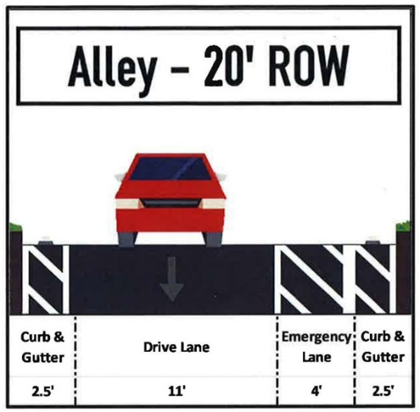
Street/Road Width Standards
Rural (50'): 7' swale + 14' drive lane + 14' drive lane + 7' swale + 8' sidewalk (either side)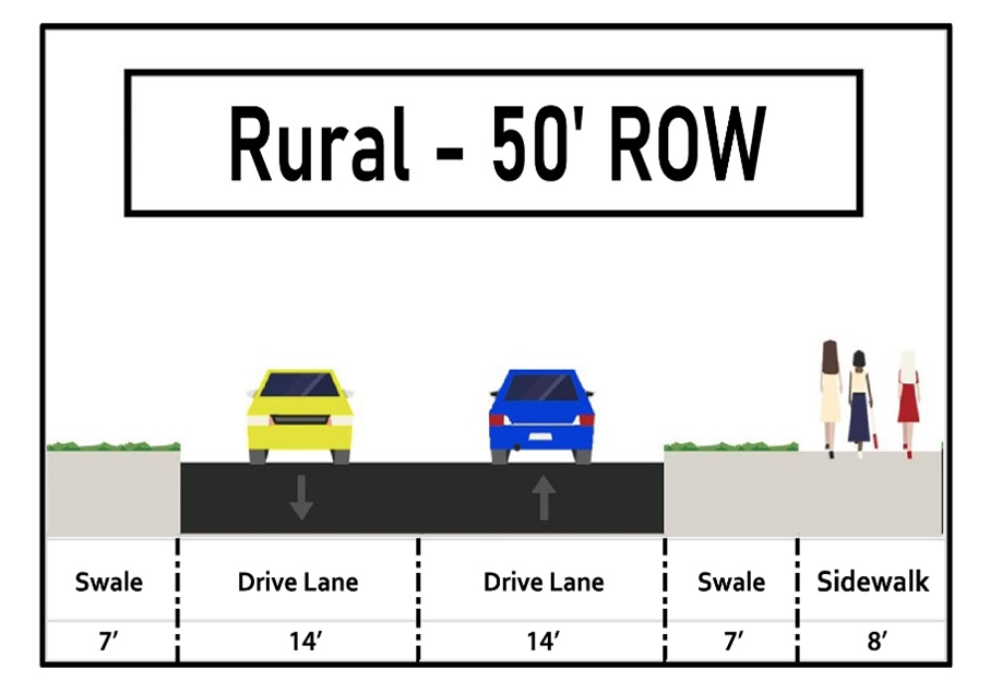
Alternative Rural (50'): 5' sidewalk + 6' swale + 14' drive lane + 14' drive lane + 6' swale + 5' sidewalk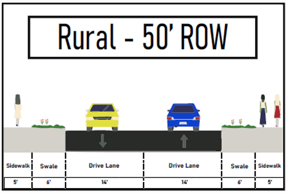
Modified (Modified Mailbox Pullout) Local (53'): 5' sidewalk, 5' parkstrip, 2.5' curb and gutter, 4' emergency lane, 10' drive lane, 10' drive lane, 9' mailbox pullout, 2.5' curb and gutter, 5' sidewalk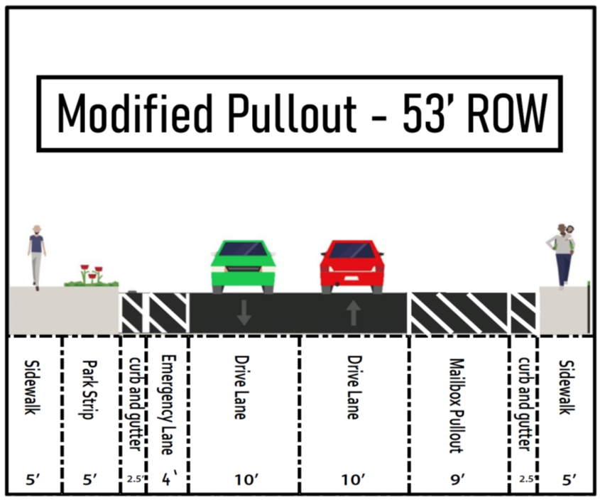
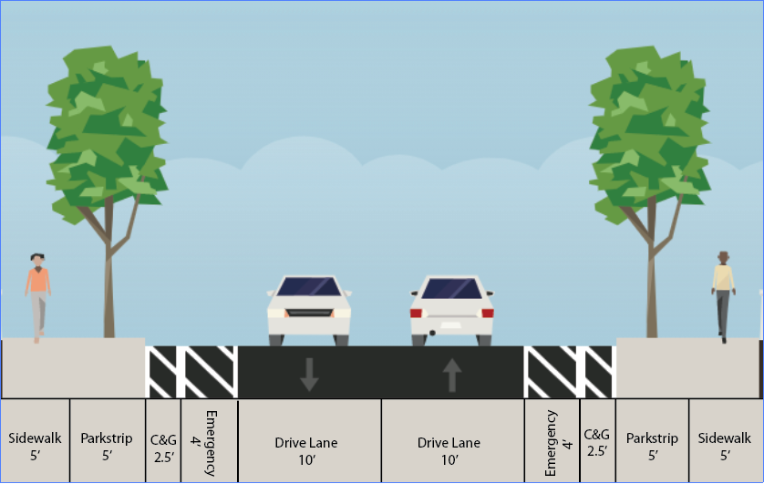
Local (59'): 5' sidewalk + 6' parkstrip + 2.5' curb and gutter + 6' emergency strip + 10' drive lane + 10' drive lane + 6' emergency strip + 2.5' curb and gutter + 6' parkstrip + 5' sidewalk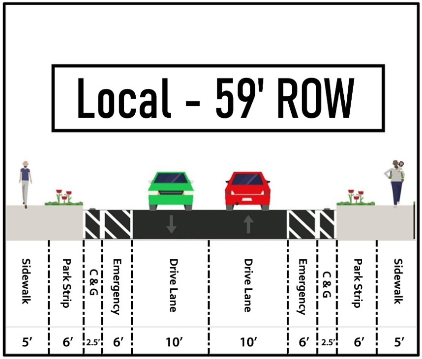
Minor Collector (77'): 8' sidewalk + 8' parkstrip + 2.5' curb and gutter + 8' parallel parking strip + 12' drive lane + 12' drive lane + 8' parallel parking strip + 2.5' curb and gutter + 8' parkstrip + 8' sidewalk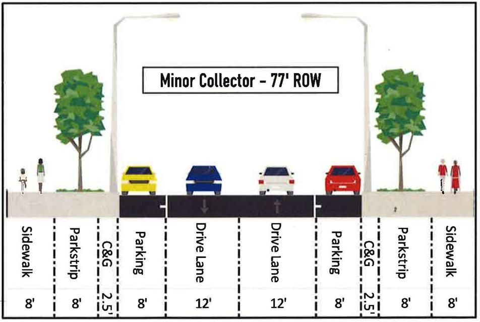
Major Collector (94'): 18' parkstrip (includes 8' path therein) + 2.5' curb and gutter + 8' parallel parking strip + 12' drive lane + 13' median + 12' drive lane + 8' parallel parking strip + 2.5' curb and gutter + 18' parkstrip (includes 8' path therein)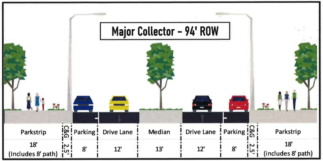
Minor Arterial (122'): 20' parkstrip (includes 8' path therein) + 2.5' curb and gutter + 8' parallel parking strip + 12' drive lane + 12' drive lane + 13' median + 12' drive lane + 12' drive lane + 8' parallel parking strip + 2.5' curb and gutter + 20' parkstrip (includes 8' path therein)
Major Arterial (152' – 5 lane): 30' parkstrip (includes 8' path therein) + 2.5' curb and gutter + 12' emergency strip + 12' drive lane + 12' drive lane + 15' median + 12' drive lane + 12' drive lane + 12' emergency strip + 2.5' curb and gutter + 30' parkstrip (includes 8' path therein)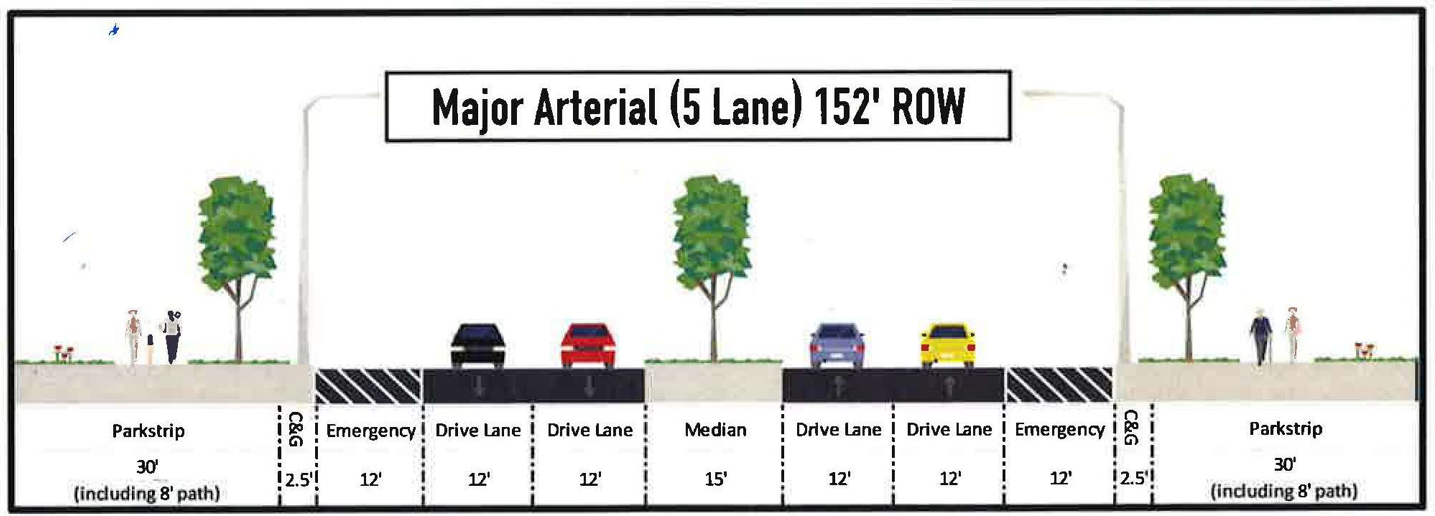
Major Arterial (176' – 7 lanes): 30' parkstrip (includes 8' path therein) + 2.5' curb and gutter + 12' emergency strip + 12' drive lane + 12' drive lane + 12' drive lane + 15' median + 12' drive lane + 12' drive lane + 12' drive lane + 12' emergency strip + 2.5' curb and gutter + 30' parkstrip (includes 8' path therein)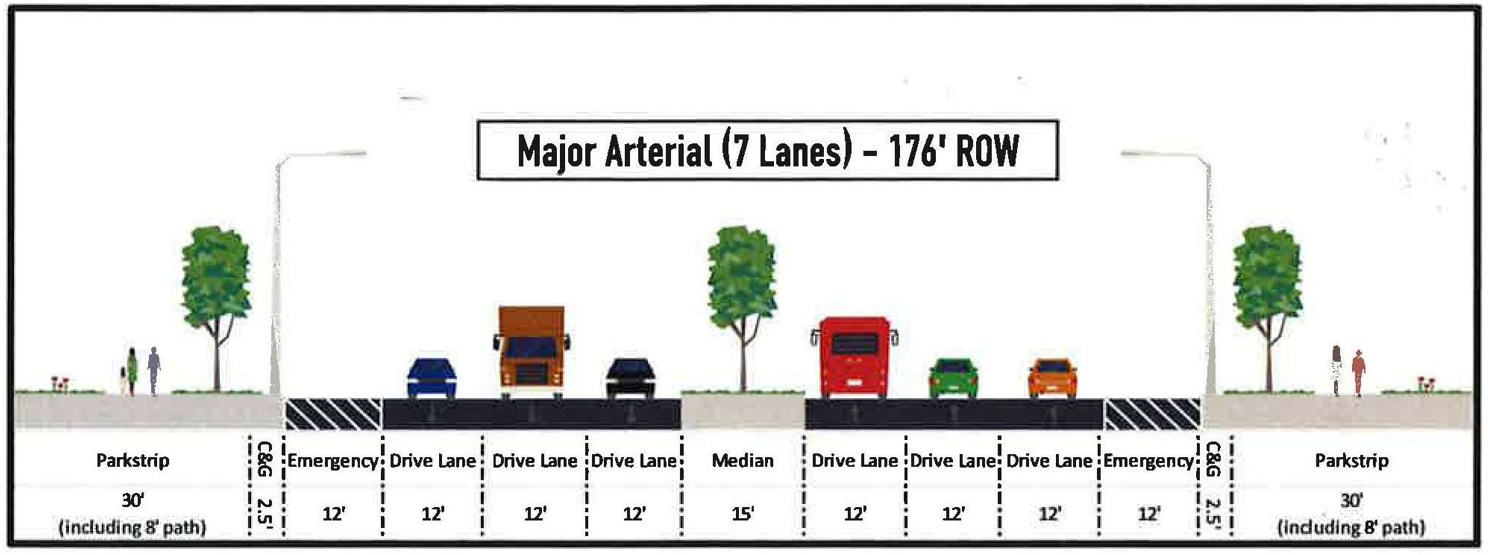
Parkway (206'): 45' parkstrip + 12' emergency strip + 12' drive lane + 12' drive lane + 12' drive lane + 30' median + 12' drive lane + 12' drive lane + 12' drive lane + 12' emergency strip + 45' parkstrip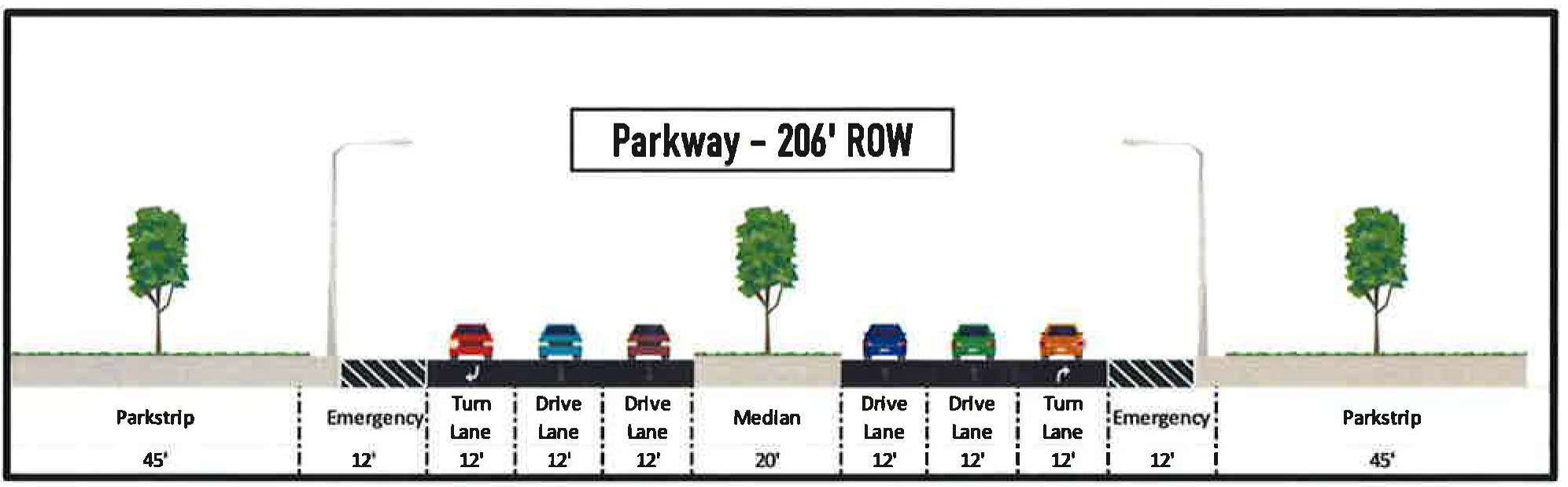
[Ord. O-24-2025 § 1 (Exh. A); Ord. O-28-2022 § 2 (Exh. A); Ord. O-20-2016 § 2 (Exh. A)].
16.35.150 Community mailboxes.
A. General Requirements. Community mailboxes are typically required for all new residential developments. Community mailboxes may be located along special mailbox pullouts or in community open spaces. Any new community mailbox must be in compliance with the standards in this chapter. Community mailbox locations shall be approved by the Eagle Mountain community development director, his or her designee, and the U.S. Postal Service.
B. Community Mailbox Spacing Standards. All homes shall be located within one-quarter mile (1,320 feet), measured along normal walking paths/routes (sidewalks, pedestrian paths, and trails).
C. Community Mailbox Locations. Community mailboxes shall be located:
1. Adjacent to a local street modified with a mailbox pullout in accordance with this title;
2. Adjacent to a private street with special mailbox pullout in compliance with this title; or
3. In a community open space.
a. Community open space mailboxes shall provide at least four off-street parking stalls adjacent to the mailbox.
b. Community open space mailboxes shall be located adjacent to a public or private ROW.
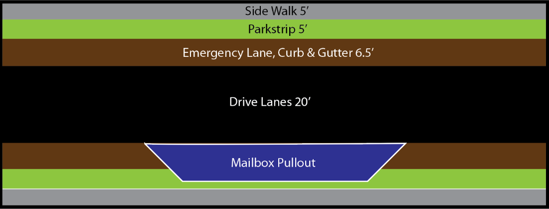
D. Mailbox Pullout Design Standards.
1. Local ROW Pullouts.
a. Community mailboxes are to be placed adjacent to a local street, the street shall utilize the modified local street with mailbox pullout, as defined in this title, for either 78 feet or 104 feet (three or four parallel parking spots). Mailbox shall be located near the center point of the pullout adjacent to the right-of-way, if located on private property a public access easement shall be granted over the mailbox location.
b. Modified mailbox pullout streets shall replace the four-foot emergency lane and five-foot parkstrip with additional pavement to serve as a pullout/parallel parking location.
c. Modified “mountable” curb and gutter shall be continued in line with curb and gutter on either side of the modified ROW, with parking lane being above the street level.
Standard Local ROW

Modified Local ROW with Mailbox Pullout
2. Private Road Mailbox Pullouts.
a. Shall include an additional nine feet of pavement adjacent to the drive aisle for a minimum of 78 feet to serve as a mailbox pullout.
3. All mailbox pullout parking spots shall be striped.
4. All mailbox parking spots shall be signed as five-minute parking zones, unless located inside a community open space. [Ord. O-20-2021 § 2 (Exh. A)].