


Chapter 17.10
ANNEXATION POLICY PLAN
Sections:
17.10.020 General requirements.
17.10.030 Property owner initiation of annexation.
17.10.040 Procedures for consideration of petition and plat.
17.10.050 Annexation petition review.
17.10.060 Municipal initiation of annexation.
17.10.070 Annexation declaration area map.
17.10.010 Purpose.
This chapter shall be the Francis City annexation policy plan and shall replace in full all prior versions of an annexation policy plan adopted by Francis City.
The annexation requirements specified in this chapter are intended to protect the general interests and character of the Francis City municipal community (“City” or “Francis City”) by assuring the orderly growth and development through: coordinating and planning utilities and public services; preserving open space, enhancing parks and trails; ensuring environmental quality; protecting entry corridors, view sheds and environmentally sensitive lands; preserving historic and cultural resources; creating buffer areas; protecting public health, safety, and welfare; and ensuring that annexations are approved consistent with the Francis City general plan, the Francis City vision and applicable laws of the state of Utah.
In meeting the goals of Francis City’s annexation policy plan, contained herein, the Planning Department and City Council shall strive to avoid gaps between or overlaps with the expansion areas of other municipalities; consider the population growth projections for Francis City and adjoining areas for the next 20 years; consider current and projected costs of infrastructure, urban services, and necessary public facilities; facilitate full development of areas within Francis City; expand infrastructure, services, and facilities into the area being considered for inclusion in the expansion area when practical and feasible; consider, in conjunction with Francis City’s general plan, the need over the next 20 years for additional land suitable for residential, commercial, and industrial development; consider the reasons for including agricultural lands, forests, recreation areas, and wildlife management areas in Francis City; and be guided by the following principles:
The areas into which Francis City may be expanded are depicted by the annexation declaration map, attached hereto as Exhibit “A” and incorporated by reference. The lands within the expansion area are presently outside the City limits and within the South Summit Fire District boundaries.
If practical and feasible, the boundaries of an area proposed for annexation shall be drawn to:
1. Eliminate islands and peninsulas of territory that are not receiving municipal type services;
2. Facilitate the consolidation of overlapping functions of local government; and
3. Promote the efficient delivery of services.
It is the intent of this chapter to ensure that property annexed to the City will contribute to the attractiveness of the community and will enhance the rural image which is critical to the economic viability of the community, and that the potential fiscal effect of an annexation does not impose an unreasonable burden upon City resources and tax base.
This chapter hereby incorporates by reference all applicable provisions of Sections 102-401 through 102-428, Utah Code Annotated 1953, as amended (hereinafter, “Utah Code”). (Ord. 2021-13 § 1 (Exh. A), 2021; Ord. 2007-12 § 1, 2007.)
17.10.020 General requirements.
The following specific requirements are hereby established for annexation to Francis City:
1. Property under consideration for annexation must be considered a logical extension of the City boundaries.
2. Annexation of property to the City must be consistent with the intent and purpose of this chapter and the Francis City general plan, in addition to the master plan for water, sewer, and roads.
3. Every annexation shall include the greatest amount of contiguous property area, which is also contiguous to the City’s municipal boundaries.
4. Piecemeal annexation of individual small properties shall be discouraged if larger contiguous parcels are available for annexation within a reasonable time frame in order to avoid repetitious annexations.
5. Islands of county jurisdiction shall not be left or created as a result of the annexation and peninsulas and irregular boundaries shall be strongly discouraged.
6. In addition to services provided by existing districts, such as sewer, fire protection, and public schools, the following urban level services, consistent with those normally provided in the rest of the incorporated boundaries will be provided to annexed areas:
a. Law enforcement protection;
b. Snow removal on public streets, subject to standard City snow removal policies;
c. Maintenance of existing public streets, provided that such streets have been constructed or reconstructed to City street standards or are acceptable to the City Engineer and City Council;
d. Planning, zoning, and municipal code enforcement;
e. Access to municipal sponsored parks and recreational activities and cultural events and facilities;
f. Water and sewage waste disposal services as the area is developed. Existing facilities for water treatment, storage and delivery, and/or for sewage removal and treatment may be inadequate to provide water and sewer services to a proposed annexation area. The City shall determine the timing of and necessary capacity for the extension of water and sewer service to a proposed annexation area. New development in an annexation area shall pay the cost of improvements necessary for the extension and connection of new developments to City water and sewer lines and systems, as well as contribute to the cost of additional capital improvements, including, but not limited to, storage and distribution facilities as necessary for safe, reliable, and efficient water flows and waste removal.
7. Before considering requests for annexation, the City shall carefully analyze the impacts of annexation of the area proposed by taking into consideration whether the area will create negative impacts on the City and considering whether the City can economically provide services to the annexed area. Community issues such as location and adequacy of schools and community facilities, traffic, fire protection, particularly in wildfire/wildland interface areas, usable open space and recreation areas, protection of sensitive lands, conservation of natural resources, protection of view corridors, protection and preservation of historic resources, affordable housing, balance of housing types and ownership, adequate water and sewer capacity to serve the future needs of the proposed annexation area shall be considered.
8. Where it is in the public interest to preserve certain lands from development in floodplains, where geologic hazards exist, where slopes are severe, or where the need for preservation of community open space and/or agricultural lands is consistent with the general plan, annexations may be used as a means to retain those lands in a natural state.
9. Francis City shall consider annexation of unincorporated areas of Summit County that are within the annexation declaration area on its own initiative in order to promote the policies set forth in FCC 17.10.010.
10. In general, the annexation of unincorporated territory which should be located within another municipality is not favored, nor the annexation of unincorporated territory solely for the purpose of acquiring municipal revenues, nor for retarding the capacity of another municipality to annex. (Ord. 2021-13 § 1 (Exh. A), 2021; Ord. 2007-12 § 2, 2007.)
17.10.030 Property owner initiation of annexation.
Annexations are initiated by filing a notice of intent with the City Recorder and by sending a copy of the notice to affected entities in accordance with Section 10-2-403, Utah Code Annotated 1953. The person or persons who filed the notice of intent must then submit a request to the county to mail the required notice to each property owner within 300 feet of the area proposed for annexation as set forth in Section 10-2-403, Utah Code Annotated 1953. The City shall provide an annexation petition upon request from the person or persons who filed the notice of intent after receiving certification from the county indicating that the required notice has been mailed. The petition shall contain and comply with the following:
1. The petition shall satisfy the criteria and formats established by the City, as well as comply with the statutory requirements set forth in Sections 10-2-401, 10-2-402, and 10-2-403, Utah Code Annotated 1953.
a. The signatures of property owners whose real property covers a majority of the private land area within the proposed annexation area, which is also equal in value to at least one-third of the value of all private real property within said area.
b. If the area is within an agriculture protection area created under Title 17, Chapter 41, Utah Code Annotated 1953, 100 percent of the private land area within the area proposed for annexation must be included.
c. If the property is owned by a public entity other than the federal government, the signature of the owner of all of the publicly owned property within the area proposed for annexation.
d. The designation of up to five of the petitioners as sponsors, one of whom shall be designated as the contact sponsor, along with the mailing address of each sponsor.
2. Attached to and as part of the petition shall be an accurate certified survey plat of the property to be annexed, prepared by a surveyor licensed to practice in Utah, accurately describing the existing City boundaries and each individual ownership sought to be annexed, including an accurate legal description of the property to be annexed.
3. A representation as to the anticipated timetable for development, if applicable, of the property being annexed.
4. If the proposed area is intended for development, a complete copy of the development concept plan, which shall also be filed at the same time (or earlier) with the City Planner. The petition shall also identify and depict any requested zoning designation on the plan or a suitable map. Impact mitigation considerations in the annexation agreement will be based on the density permitted under the requested or applied zone requirements.
5. Depending on the scope and intensity of proposed development of the annexation area and the anticipated impact on adjacent lands, the applicant shall prepare and submit a review and analysis of the surrounding property, as provided in FCC 17.10.050(5), including but not limited to a wetlands delineation.
6. Zoning requests are subject to independent review and recommendation by the Planning Commission, with final approval by the City Council concurrent with public hearings on the proposed annexation.
7. There shall also be attached to the annexation petition a full disclosure statement of any and all waters owned or historically utilized on the property to be annexed.
8. The annexation petition shall not propose annexation of any land area proposed for annexation to a municipality in a previously filed petition that has not been granted, denied, or rejected.
9. The annexation petition shall not propose annexation of any land area being considered as part of any area proposed for incorporation as a municipality under Utah State law.
10. On the date of filing the annexation petition with the City Recorder, the petition sponsor(s) shall also deliver a copy of the petition to the clerk of the county or counties in which the annexation area is located. (Ord. 2021-13 § 1 (Exh. A), 2021; Ord. 2017-04 § 1, 2017; Ord. 2007-12 § 3, 2007.)
17.10.040 Procedures for consideration of petition and plat.
The procedure for processing an annexation petition and plat shall be as follows:
1. A petition and proper plat certified by a licensed surveyor shall be submitted to the City Recorder in accordance with Section 10-2-403(2)(C), Utah Code Annotated 1953, together with such other information as may be required by the City Planner to enable the staff to prepare a written recommendation.
2. Prior to City Council action on the petition, the petition and plat shall be reviewed by the City Planner, who shall evaluate the feasibility of the subject expansion of the City’s boundaries and who shall prepare a written recommendation for consideration by the City Council.
3. If the City Council determines that the annexation petition provides the information and representations required by FCC 17.10.030, the petition may be accepted for further consideration under FCC 17.10.050 and delivered to the City Recorder for consideration of certification pursuant to Section 10-2-405, Utah Code Annotated 1953.
4. The City Recorder shall determine, within the time frame and according to the provisions of Section 10-2-405, Utah Code Annotated 1953, whether the petition should be certified. If the petition is certifiable, the City Recorder shall publish notification thereof in accordance with Section 10-2-406, Utah Code Annotated 1953. The City Recorder shall mail written notice of certification to the school district, fire district, any special service district, utility companies, and the County Clerk.
5. If certified by the City Recorder, the Planning Commission shall hold a public hearing and thereafter make a recommendation on the annexation proposal, including any requested zoning designation, to the City Council.
6. After receipt of the Planning Commission’s recommendation, completion of the review and evaluation provided for by FCC 17.10.050, and after giving notice pursuant to Section 102-407, Utah Code Annotated 1953, the City Council shall hold a public hearing on the proposed annexation. Following public hearing, the City Council may either grant the petition, with or without conditions, or deny it. If granted, and upon compliance with all conditions, an ordinance affirming the annexation shall be enacted; provided, however, that protests to an annexation petition shall be dealt with as set forth in Section 10-2-407, Utah Code Annotated 1953. Denial of or granting the petition while a protest is pending is subject to Section 10-2-408, Utah Code Annotated 1953.
7. Once the City Council enacts an ordinance annexing an unincorporated area or adjusting a boundary all applicable zoning and land management code provisions shall apply to the annexed property.
8. As a condition to recordation of the annexation ordinance, the City may require the execution of an annexation agreement pursuant to FCC 17.10.050(3).
9. Within 30 days after enacting an ordinance annexing an unincorporated area or adjusting a boundary, the City shall:
a. Record with the Summit County Recorder a certified copy of the ordinance approving the annexation or boundary adjustment, together with the annexation plat or map prepared by a licensed surveyor and approved by the City, showing the new boundaries of the affected area.
b. File with the Lieutenant Governor of the state of Utah the amended articles of incorporation reflecting the annexation or boundary adjustment, as provided in Section 10-1-117, Utah Code Annotated 1953.
c. Comply with the notice requirements of Section 10-1-116, Utah Code Annotated 1953. (Ord. 2021-13 § 1 (Exh. A), 2021; Ord. 2007-12 § 4, 2007.)
17.10.050 Annexation petition review.
1. Staff Review Team. After the acceptance of a petition by the City Council and certification thereof by the City Recorder, the procedure for annexation shall comply with the Utah Code; provided, however, the City Council shall not take final action on any petition until the same has been reviewed by the City Planning Commission and by the staff review team.
2. Annexation Evaluation and Staff Report. The staff review team will review each annexation and zoning request. The Planning Department will prepare a staff report based thereon and with recommendation to the Planning Commission. The staff report shall include an evaluation of the proposed annexation and shall include at least such of the following information as deemed necessary and appropriate in consideration of the scope of the proposed annexation:
a. The ability to meet the general annexation requirements set forth in FCC 17.10.020.
b. An accurate map of the proposed annexation area showing the boundaries and property ownership within the area, the topography of the area and major natural features, e.g., drainage, channels, streams, wooded areas, areas of high water table, very steep slopes, sensitive ridgeline areas, wildfire/wildland interface areas, and other environmentally sensitive lands.
c. Identification of current and potential population of the area and the current residential densities.
d. Land uses presently existing and those proposed.
e. Character and development of adjacent properties and neighborhoods.
f. Present zoning and proposed zoning.
g. A statement as to how the proposed area, and/or its potential land use, will contribute to the achievement of the goals and policies of the Francis City general plan and Francis City vision.
h. Assessed valuation of the properties within the annexation area.
i. Potential demand for various municipal services and the need for land use regulation in the area, e.g., consideration of the distance from existing utility lines, special requirements for sensitive lands review and fire protection in wildfire or wildland areas, location within hazardous soils areas, and feasibility of snow removal from public streets.
j. The effect the annexation will have upon City boundaries and whether the annexation will ultimately create potential for future islands, undesirable boundaries, and difficult service areas.
k. A proposed timetable for extending municipal services to the area and recommendation on how the cost thereof will be paid.
l. Comparison of potential revenue from the annexed properties with cost of providing services thereto.
m. An estimate of the tax consequences and other potential economic impacts to residents of the area to be annexed.
n. Recommendations or comments of other local government jurisdictions regarding the annexation proposal and potential impact of the annexation on general county economic needs, goals, or objectives.
o. Location and description of any historic or cultural resources.
3. Conditions of Annexation Approval and Annexation Agreement. The following conditions must be met prior to approval of an annexation, unless the City Council determines that the particular circumstances of a proposed annexation do not require the imposition of some, or all, of such conditions. These conditions shall be applied consistently for each proposal; however, unusual or unique circumstances may exist which require the imposition of additional, special conditions. The conditions of approval may be required to be formalized by written annexation agreement. The annexation agreement shall be approved by the City Attorney, reviewed by the Planning Commission, signed by the City Council and recorded with the Summit County Recorder.
a. Identification of usable water rights to be transferred to Francis City to serve the proposed development.
b. Additional improvements as necessary which may be required in order to improve the water system.
c. Identification of usable water rights to be transferred to Francis City to serve the proposed development. Dedication of necessary streets, trails, utilities, and rights-of-way consistent with the subdivision standards of this code.
d. Phasing of the development and the annexed area to insure adequacy of public facilities if necessary.
e. Agreement to an annexation fee in the amount of $8,000 per equivalent residential unit constructed on the annexation property, but this fee may be adjusted up or down or waived by the City Council for any particular annexation, but only for just cause, as determined in the City Council’s sole discretion in findings to be set forth in writing.
f. Dedication of open space or conservation areas.
g. Payment of other fees required by the City, including planning, engineering, legal and other professional and consulting fees.
h. Provision of affordable housing in accordance with any affordable housing resolution as may be in effect at the time of petition filing.
i. Submittal of site plans and architectural plans for review.
j. A sunset clause setting a deadline on the applicant’s density allowance specified in the annexation agreement (if any).
k. Floodplain management or preservation of environmentally sensitive lands including compliance with the sensitive lands provisions of the City code.
l. Analysis and survey of any historic and cultural resources located on the property.
m. Analysis of the fiscal impacts of the development as determined necessary by the City. The fiscal impact analysis format, including the revenue and cost assumptions, shall be approved by the City. If necessary, the City may retain a qualified consultant to perform the fiscal impact analysis, at the expense of the applicant.
n. Fees paid in lieu of satisfying certain conditions, as may be approved by the City Council.
o. Review of surrounding property as described in subsection (5) of this section.
p. Any other condition reasonably related to a health, safety, or welfare issue or negative impact of the annexation and any proposed development thereof.
4. Amendments to the Annexation Agreement. Subsequent amendments to an annexation agreement which are substantive in nature shall be subject to review by the Planning Commission and approval by the City Council, following reasonable public notice. Substantive amendments shall also be recorded with the Summit County Recorder.
5. Review and Analysis of Surrounding Property. Upon consideration of the impact of the proposed annexation, the City Planner may require that a land use review and analysis of surrounding property be submitted with the annexation petition. This analysis of surrounding property shall be in sufficient detail for the City to determine the long-term community impacts of the proposed annexation on these properties. This analysis may include, but is not limited to, all property within one-half mile of the boundaries of the proposed annexation. The City Planner may modify the study area one-half mile more or less to achieve a suitable and logical study area. The review and analysis of surrounding property shall be performed by a qualified land use planner with assistance from other professionals, such as traffic engineers, civil engineers, wildlife biologists, hydrologists, and soils scientists. The City reserves the option of selecting the qualified professionals to perform this analysis with the cost to be paid by the applicant. The review and analysis shall include, but is not limited to, a study of the following:
a. Slope, wetlands, vegetation, wildlife habitat, view corridors, existing historic and cultural resources, and significant geological features.
b. Existing and proposed road systems.
c. Existing and proposed utilities and major utility extension plans.
d. Location of existing and proposed open space, recreational areas and trail systems.
e. Existing and proposed land uses including type and density of residential areas.
f. Existing and proposed locations of community facilities such as fire stations, schools, parks, recreation centers, etc. (Ord. 2021-13 § 1 (Exh. A), 2021; Ord. 2017-04 § 1, 2017; Ord. 2007-12 § 5, 2007.)
17.10.060 Municipal initiation of annexation.
It shall be the policy of Francis City to annex on its own initiative such areas which meet all of the following criteria:
1. The area is an island within or a peninsula contiguous to the City;
2. The majority of each island or peninsula consists of residential or commercial development;
3. The area requires the delivery of municipal-type services;
4. The City has provided most or all of the municipal-type services to the area for more than one year; and
5. Annexation of the area is supported by the goals of the Francis City general plan, including open space, land use, affordable housing, recreation, growth management and economic development.
Such annexations shall be processed as provided under Section 10-2-418, Utah Code Annotated 1953, including all noticing and public hearing requirements. This review shall be in addition to the review required in FCC 17.10.050.
The City may not adopt an annexation ordinance based on its own initiative unless the Summit County Commission has previously approved the annexation.
If written protest to such annexation is timely filed and complies with Section 10-2-418(3), Utah Code Annotated 1953, the City may not adopt an ordinance annexing the area proposed for annexation, and the annexation proceedings under this section shall be considered terminated. (Ord. 2021-13 § 1 (Exh. A), 2021; Ord. 2007-12 § 6, 2007.)
17.10.070 Annexation declaration area map.
1. The annexation declaration area map is included as Exhibit A. The map may be altered to change the proposed annexation boundaries of Francis City upon action by the City Council upon recommendation by the Planning Commission and following public hearing duly noticed.
2. The following criteria were used as justification to exclude lands from the expansion area:
a. Topography and other physical constraints to efficient delivery of basic services;
b. Overlapping utility services already being supplied by other providers;
c. Level of existing services, or quality of construction and condition of existing roads and habitable structures below City standards, requiring expensive upgrades;
d. Other negative fiscal consequences to the City. (Ord. 2021-13 § 1 (Exh. A), 2021; Ord. 2007-12 § 7, 2007.)
Exhibit A
Annexation Declaration Map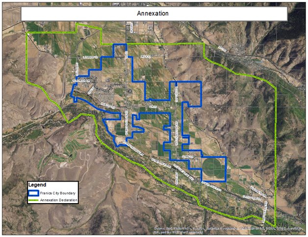
(Ord. 2021-13 § 1 (Exh. A), 2021.)