


Article 4 Special Purpose and Overlay Districts Revised 12/22 Revised 12/23
4.1 General
4.1.1 Special purpose districts
Special purpose districts are base districts established to provide standards addressing unique circumstances or conditions affecting single sites where the development of such sites is of special public concern. Upon approval of special purpose district zoning, the special purpose district replaces the previous base district.
4.1.2 Overlay districts
Overlay districts are established to provide for certain additional requirements for properties located in one or more base zoning districts. Thus, in addition to the requirements of the underlying base zoning district, the provisions of the overlay district would also prevail in the areas so zoned. In certain areas of Grand County, two or more overlay districts may apply. In any such instance where there are conflicting provisions, the more stringent requirements shall apply.
4.2 SPA, Specially Planned Area
4.2.1 Purpose
The SPA, Specially Planned Area District is a special purpose district designed to implement the Moab/Grand County North Gateway Plan, an amendment to the Grand County General Plan. The SPA district is intended to serve as “interim” zoning for the Moab mill site (Atlas) pending the completion of the anticipated reclamation and remediation activities. While the district permits low density residential uses, community preference at this time is that the land be restored to a relatively natural state and preserved as open space. Upon completion of the site reclamation, more specific land uses should be determined following site-specific future land use planning as part of a General Plan amendment. In addition to the use and dimensional standards of this section, development in the SPA district shall be in compliance with all other applicable provisions of this LUC.
4.2.2 Permitted Uses
The following uses shall be permitted-by-right:
Dwelling unit, single-family
County facilities
Essential services
4.2.3 Conditional Uses
Conditional uses shall be allowed in accordance with Section 9.11.
Mining and extractive uses, subject to the use-specific standards or Section 3.2.4D.
Waste materials management facilities and uses, subject to the use-specific standards of 3.2.4N.
4.2.4 Accessory Uses
The following accessory uses shall be allowed:
Accessory use or structure, subject to the use-specific standards of Section 3.3.
Home occupation, subject to the use-specific standards of Section 3.3.2G.
4.2.5 Temporary Uses
Temporary uses shall be allowed in accordance with Section 9.11 of this LUC.
Field office, temporary, subject to the use-specific standards of Section 3.3.3B.
4.2.6 Lot Design Standards
Development in the SPA District shall be subject to the following standards:
A. Minimum Lot Area: 5 Acres
B. Minimum Front and Street Side Setbacks: 25 Feet
C. Minimum Rear and Interior Side Setbacks:
1. Principal structures: 10 feet
2. Accessory structures: See Section 3.3
D. Minimum Lot Width: 400 Feet
E. Maximum Height: 24 Feet
4.2.7 Special Open Space Requirement
Notwithstanding provisions to the contrary, the minimum undeveloped open space in each development within the SPA District shall be 80 percent.
4.2.8 District Standards
All land uses and structures shall:
A. Be placed on a slab-on-grade or perimeter foundation;
B. Have a minimum 24 feet horizontal wall dimension on at least 2 non-opposite sides; i.e., other than directly opposite sides of the structure;
C. Utilize medium to darker earth tones and non-reflective materials on all structures, including roofs, to minimize contrast and blend with the surrounding natural landscape without calling undue attention to the development; and
D. Cluster all allowable residential density on the 20 percent of the property that is least visible from high public use areas.
4.3 AL, Airport Limitation District
4.3.1 Purpose
The AL, Airport Limitation District is a special purpose district intended to establish standards assuring the long-range, safe and beneficial use of Canyonlands Field.
4.3.2 Airport Zoning Commission
A. Commission Established
1. The Grand County Planning Commission is designated as the "Airport Zoning Commission" as prescribed in Utah Code §72-10-405.
2. In this LUC and State law, any references to the "Airport Zoning Commission" shall mean the Grand County Planning Commission.
3. If the Planning Commission is empowered in this LUC to take actions that are duties of the Airport Zoning Commission as prescribed in Utah law the Planning Commission shall be presumed to be functioning as the Airport Zoning Commission.
B. Duties
The Airport Zoning Commission shall recommend boundaries of the various zones to be established and the regulations to be adopted pertaining to any airport hazard area and to perform such other duties as may be assigned to it by the County Commission or Utah law.
4.3.3 Airport Board of Adjustment
A. Board Established
1. The Grand County Airport Board shall designate an "Airport Board of Adjustment" as prescribed in Section 72-10-410, Utah Code Annotated 1953.
2. The Board of Adjustment shall consist of five members, each to be appointed for a term of three years, by Grand County Commission and to be removable for cause, upon written charges and after public hearing.
B. Procedure
Any person aggrieved, or taxpayer affected, by any decision of any administrative agency made in its administration of airport zoning regulations adopted by Grand County, which is of the opinion that a decision of an administrative agency is an improper application of airport zoning regulations of concern to the governing body or board, may appeal to the Board of Adjustment authorized to hear and decide appeals as provided in this Section 4.3.
C. Duties
1. The Airport Board of Adjustment shall hear and decide appeals from any order, requirement, decision, or determination made by the administrative agency in the enforcement of the airport zoning regulations, as provided in Section 72-10-408, Utah Code Annotated 1953, and to perform such other duties as may be assigned it by the County Commission or Utah law.
2. To hear and decide specific variances as provided in Section 72-10-407(2), Utah Code Annotated 1953. [Ord. 537, 2015.]
4.3.4 Grand County Airport Board
A. Board Established
The Grand County Airport Board is designated as the principal advisory body to the Grand County Commission in all matters related to the operation of Canyonlands Field.
B. Duties
The members shall in all cases act as a board, rather than as individuals. The Grand County Airport Board may adopt rules and procedures for the conduct of its meetings and to govern its operation, not inconsistent with bylaws, County ordinances, and regulations of the State of Utah and the FAA.
4.3.5 Lot Design Standards
Development in the AL district shall be subject to the following standards:
A. Minimum Lot Area: 5 Acres
B. Minimum Front and Street Side Setbacks: 25 Feet
C. Minimum Rear and Interior Side Setbacks:
1. Principal structures: 10 feet
2. Accessory structures: See Section 3.3
D. Minimum Lot Width: 400 Feet
E. Maximum Height: 24 Feet
4.3.6 Permitted Uses
The following uses shall be permitted-by-right
A. Residential Uses
See Section 4.3.9D
B. Public or Civic Uses
Essential services
C. Retail, Service and office Uses
Those allowed by the Airport Master Plan
D. Agriculture and Agriculture Related Uses
Agricultural animals, subject to the use-specific standards of 3.2.5A
Farm, orchard or truck garden
Grazing
E. Industrial, Communications, Transportation and Automobile-Related Uses
Airport
4.3.7 Conditional Uses
Conditional uses shall be allowed in accordance with Section 9.11.
Animal pound or kennel (public or private)
Barn, corral, pen, coop or machinery shed, subject to the use-specific standards of 3.2.5B
Dwelling, single-family
Dude ranch or destination resort, subject to the use-specific standards of 3.2.3F
Electric substation
Mining
Manufactured home, subject to the use-specific standards of 3.2.1H
Oil and gas drilling
Waste materials management, subject to the use-specific standards of 3.2.4N
4.3.8 Accessory Uses
The following accessory uses shall be allowed:
Accessory use or structure, subject to the use-specific standards of Section 3.3
Dwelling unit, accessory, subject to the use-specific standards of Section 3.3.2B
4.3.9 District Standards
All uses in the AL District shall be in compliance with the Airport Master Plan, Airport Layout Plan, and Noise Contour Map as adopted by the Grand County Airport Board, and incorporated into this section by reference as it pertains to airport land uses, and subject to the regulations of this section:
A. Conforming Uses only
All uses in the AL District shall be subject to the height and use standards as prescribed in this LUC or as prescribed in State or Federal standards.
B. Creation of Airport Hazards Prohibited
No variance, permit, or use shall be allowed that would create or enhance an airport hazard.
C. General Use and Operational Limitations
No use shall be permitted which:
1. Creates or tends to create electrical interference to navigational devices and communication between aircraft and airports;
2. Creates or tends to create gas, smoke, dust, glare, or other visual hazard in the atmosphere around airports or in the airport hazard area;
3. Creates or tends to create structures that interfere with aircraft safety; or
4. Creates or tends to create any type of hazard for the airport that would inhibit or constrain safe and acceptable airport operations
D. Residential Use Limitation
All allowed residential uses shall be shown on the Airport Layout consistent with the Airport Master Plan, and be restricted for airport personnel only.
E. Height Limitation
The maximum height for all structures, except for the airport tower, air service buildings and facilities approved as part of the Airport Layout Plan, shall be 35 feet. The height of the airport tower, air service buildings and facilities shall be in accordance with the Airport Layout Plan. Notwithstanding the foregoing, in no case shall a structure be at a height that creates or tends to create an airport hazard.
F. Architecture and Landscaping
1. The architectural style of accessory hangers, storage and maintenance facilities, and similar service uses shall be complementary to the principal structures and appropriate for the site and proposed use.
2. The landscaping around the buildings shall be low maintenance and extend 20 feet around the buildings.
3. All buildings shall comply with applicable Federal, State and local Standards.
4.3.10 Mandatory Referral
Prior to the issuance of zoning development or Building Permit, permit applications shall be referred to the Airport Board and to the Federal Aviation Administration, Denver Airports District office (FAA) for comment. In making its determination as to whether a proposed land use is consistent with the standards of this section, the County shall give substantial weight to the recommendations of the Grand County Airport Board and the FAA.
4.4 -PUD, Planned Unit Development Revised 12/23
4.4.1 Purpose and intent Revised 12/23
The -PUD, Planned Unit Development, is an overlay district designed to provide for modification of the otherwise applicable dimensional and density standards of the underlying base district as specified in Article 5, Lot Design Standards, in order to accomplish one or more of the following purposes:
A. Promote flexibility in the siting of structures so as to preserve and take advantage of the site’s unique, natural, resource or scenic features and to avoid or mitigate any hazardous area; 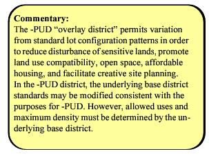
B. Provide density bonus incentives in the interest of creating affordable housing, workforce housing, and beneficial open space;
C. Encourage more efficient use of land and public streets, utilities, and governmental services;
D. Promote a clustering development pattern in the interest of preserving rural character;
E. Preserve open space for the benefit of residents of developments and the community;
F. Achieve a compatible land use relationship with surrounding areas; and
G. Promote greater variety in the type and design of buildings and thereby improving the character and quality of new development.
[Ord. 681, 2023.]
4.4.2 Applicability Revised 12/23
Upon approval, the underlying base zoning district as modified by the approved -PUD master plan shall control development within a -PUD district. -PUD district master plans may be approved for properties in single ownership or in contiguous (multiple) ownership or control. [Ord. 681, 2023.]
4.4.3 Approval Procedures Revised 12/23
-PUD district developments shall be reviewed and approved in accordance with the procedures of Section 9.2, Text and Zoning Map Amendments (Rezonings), and shall be considered to be a zoning map amendment. [Ord. 681, 2023.]
4.4.4 Identification on Zoning Maps Revised 12/23
Approved -PUD district developments shall be indicated on the official Zoning Map. [Ord. 681, 2023.]
4.4.5 Allowed Uses Revised 12/23
Any use or combination of uses allowed by the underlying base district(s) are permitted in a Planned Unit Development; provided, that nonresidential uses shall be those of the underlying zoning district. [Ord. 681, 2023.]
4.4.6 Lot Design Standards Revised 12/23
In order to achieve the purpose and intent of these -PUD regulations, variation may be permitted relative to underlying base district standards with respect to the minimum lot area, setbacks, and lot width. [Ord. 681, 2023.]
4.4.7 Density Revised 12/23
Maximum density shall be no greater than that permitted in the underlying zone district prior to -PUD approval unless the project meets the requirements for affordable housing density bonus incentives (in accordance with Section 4.4.8), workforce housing density bonus incentives (in accordance with Section 4.4.9), or open space density bonus incentives (in accordance with Section 4.4.10). [Ord. 681, 2023.]
4.4.8 Affordable Housing, Density Bonus Incentives Revised 12/23
Maximum residential density may be increased at the option of the developer in the SLR and LLR base zoning districts in accordance with the requirements of this section; provided, that at least 50 percent of the bonus dwelling units provided in “Density Incentive 1” and 70 percent of the bonus dwelling units provided in “Density Incentive 2” shall be affordable housing restricted in accordance with the requirements of Section 6.14. Maximum allowed density by district shall be as follows:
|
Maximum Density by District (Units per Gross Acre) |
|||||||||
|---|---|---|---|---|---|---|---|---|---|
|
Qualifying Zone Districts |
Conventional |
Affordable Housing Incentive 1 |
Affordable Housing Incentive 2 |
||||||
|
Density Bonus (Units/Acre) |
Unit Increase |
% Increase |
Affordable Housing Units |
Density Bonus (Units/Acre) |
Unit Increase |
% Increase |
Affordable Housing Units |
||
|
SLR, Small Lot Residential |
5 |
8.0 |
3.0 |
60% |
2 |
10.0 |
5.0 |
100% |
4 |
|
LLR, Large Lot Residential |
2 |
3.0 |
1.0 |
50% |
1 |
3.6 |
1.6 |
80% |
1 |
|
NOTE: When calculating the affordable housing units, if the decimal portion is less than 0.5, round down; if the decimal portion is equal or more than 0.5, round up. |
|||||||||
[Ord. 681, 2023.]
4.4.9 Workforce Housing, Density Bonus Incentives Revised 12/23
Maximum residential density may be increased at the option of the developer in the SLR and LLR base zoning districts in accordance with the requirements of this section; provided, that at least 50 percent of the bonus dwelling units provided in “Density Incentive 1” and 80 percent of the bonus dwelling units provided in “Density Incentive 2” shall be restricted for ownership and occupancy by actively employed households as defined in Section 4.7.3. Maximum allowed density by district shall be as follows:
|
Maximum Density by District (Units per Gross Acre) |
|||||||||
|---|---|---|---|---|---|---|---|---|---|
|
Qualifying Zone Districts |
Conventional |
Workforce Housing Incentive 1 |
Workforce Housing Incentive 2 |
||||||
|
Density Bonus (Units/Acre) |
Unit Increase |
% Increase |
Workforce Housing Units |
Density Bonus (Units/Acre) |
Unit Increase |
% Increase |
Workforce Housing Units |
||
|
SLR, Small Lot Residential |
5 |
8.0 |
3.0 |
60% |
2 |
9.5 |
4.5 |
90% |
4 |
|
LLR, Large Lot Residential |
2 |
3.0 |
1.0 |
50% |
1 |
3.5 |
1.5 |
75% |
1 |
|
NOTE: When calculating the workforce housing units, if the decimal portion is less than 0.5, round down; if the decimal portion is equal or more than 0.5, round up. |
|||||||||
[Ord. 681, 2023.]
4.4.10 Open Space, Density Bonus Incentives Revised 12/23
A density bonus of up to 20 percent may be approved at the recommendation of Planning Commission for projects providing 20 percent or more open space.
Beneficial open space eligible for the density bonus shall provide the following:
A. Open space that promotes the preservation of productive agricultural land (see Section 10.2).
B. Open space that promotes access to public lands, connections to existing or planned trails, and riparian and historic trail corridors. Such open space shall be freely accessible to the general public, and clearly identified by on-site signage. Trails shall be constructed in accordance with Section 7.4 and maintained by the mandatory homeowners association in accordance with Section 9.6.
[Ord. 681, 2023; Ord. 544, 2016.]
4.4.11 Master Plan Requirement Revised 12/23
In approving a -PUD district development in accordance with this section, the County Commission shall require a master plan of the development. A comparison of the proposed development with the standards of underlying zoning district and a statement by the applicant describing how the proposed development provides greater benefits to the County than would a development carried out in accordance with otherwise applicable zoning and development regulations;
A. A statement by the applicant describing how the proposed development provides greater benefits to the County than would a development carried out in accordance with otherwise applicable zoning and development regulations;
B. Identification of lands that include public drinking water supply watersheds (recharge areas for the aquifer in the Glen Canyon formation); floodplains and riparian habitats; slopes in excess of 30 percent, and significant geological, biological, and archeological sites (not all of these will apply to every parcel);
C. Identification of site planning features designed to ensure compatibility between on-site residential and nonresidential uses, and with the surrounding neighborhood and land uses;
D. A narrative addressing the proposed development explaining and tabulating the land uses by gross acre, number of dwelling units by housing type, residential density and/or square footage of nonresidential uses per gross acre, common area and open space acreage, potential traffic generation, overall character and architectural style, the relationship of the proposed development to existing development in the area and other related development features;
E. A site plan prepared in accordance with the requirements of Section 9.17 shall be approved and filed with the findings of fact as part of the approval, including but not limited to major roads, trails and trail connections, major utilities, existing and proposed land uses, common area, open space, landscaping plan, a conceptual drainage plan and entrance locations on existing roads;
F. Dimensional standards to be modified within the -PUD district relative to the underlying base district standards;
G. A statement of how the proposed development is consistent with the General Plan; and
H. Other relevant information as may be requested by the Zoning Administrator.
[Ord. 681, 2023; Ord. 544, 2016.]
4.4.12 Public Land Dedications Revised 12/23
In addition to land required for public rights-of-way and easements, the County shall require the dedication to the County of:
A. Land for public facilities pursuant to the provisions of Section 6.13.7, Extraordinary Impact; including but not limited to, public schools, fire stations, water storage, well fields, public parks and trails that are necessary to serve the development;
B. Easements for scenic corridors or preservation that benefit the general public;
C. Rights-of-way for non-mechanized trails shall be dedicated as necessary to maintain historic access to public lands and trail connections to surrounding area and as part of the Grand County Master Plan for Non-Motorized Trails (Trail Mix); such dedications shall also include documented or verifiable historic trails perhaps not included in the Trail Mix; and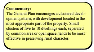
D. Historic sites and buildings.
[Ord. 681, 2023; Ord. 544, 2016.]
4.4.13 Architectural Review Revised 12/23
The Planning and Zoning Commission may require an architectural site plan to review for the purpose of promoting the preservation of the visual character of the neighborhood, the stability of land values, the public safety, and the general welfare by preventing the erection of structures or additions or alterations which are not properly related to their sites or to prevent the indiscriminate clearing of property, excessive grading, and the destruction of trees and shrubbery. In carrying out the purpose of this section with respect to the external design of the buildings, approval shall be considered in accordance with the following objectives:
A. Reducing the adverse visual impacts of structures which, because of size, scale, color or location, are out of harmony with the neighborhood in which they are to be constructed.
B. Minimizing disturbances to the natural terrain and existing significant vegetation; enhancing drainage; reducing soil erosion; and otherwise maximizing compatibility with the regulations of this LUC.
C. It is the intent of this section that the County shall exercise the minimum control necessary to achieve the overall objectives thereof.
[Ord. 681, 2023; Ord. 544, 2016.]
4.4.14 Road Design Standards Revised 12/23
Variation from otherwise required road design standards may be approved where the applicant demonstrates to the satisfaction of the County that such exception will not be detrimental to the public health, safety and general welfare, and where private road maintenance is provided by a homeowners’ association or other similar entity. [Ord. 681, 2023. Formerly 4.4.9.]
4.4.15 Additional Conditions Revised 12/23
The County shall impose such other conditions as are deemed necessary to accomplish the purposes of this section, this LUC and the General Plan. [Ord. 681, 2023; Ord. 544, 2016. Formerly 4.4.14.]
4.4.16 Minor Amendments Revised 12/23
A. The following minor amendments to -PUD master plans shall be reviewed and, if appropriate, approved by the Zoning Administrator:
1. Changes that result in a decrease in assigned density or intensity for a specific parcel, either residential or nonresidential.
2. Change in land use designation from multifamily to single-family or a change from any other use to common area or open space.
3. Change in major infrastructure features (e.g., roads/access, sewer, water, storm drainage) of the master plan area, which are beneficial to the residents of the master plan area.
4. Change in land use designation from single-family to multifamily with no increase in permitted site-specific density.
B. The applicant requesting such change shall notify the property owners’ association, at least 15 days prior to any decision, that would be affected by the change of the request and ask that all comments be directed to the Zoning Administrator. Proof of such notification shall be provided to the Zoning Administrator. If the Zoning Administrator determines that the change does not have the support of the affected property owners, the request will be referred to the Planning Commission for review.
[Ord. 681, 2023; Ord. 544, 2016. Formerly 4.4.15.]
4.4.17 Major Amendments Revised 12/23
All other proposed amendments to a listed master plan or master plan text not specifically addressed above shall be considered major amendments and must be processed in accordance with the procedures and requirements of Section 9.2, Text and Zoning Map Amendments (Rezonings). [Ord. 681, 2023; Ord. 544, 2016. Formerly 4.4.16.]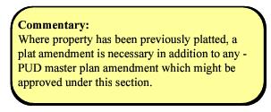
4.4.18 Effect on Other Code Standards Revised 12/23
Except as expressly authorized by the regulations of this section and approved as a part of a -PUD master plan in accordance with the procedures of Section 9.2, Text and Zoning Map Amendments (Rezonings), the standards of this LUC shall apply to development within a -PUD. [Ord. 681, 2023; Ord. 544, 2016. Formerly 4.4.17.]
4.5 -WSPO, Water Source Protection Overlay District
4.5.1 Purpose
The -WSPO, Water Source Protection Overlay District is an overlay district intended to protect ground water and the recharge basin for current and future public, culinary water supplies in Grand County. To this end, the –WSPO district shall be applied to recharge areas designated according to U.S. EPA Sole Source Aquifer recharge area and approved by the Utah Division of Drinking Water, or other resource specific study approved by the state engineer. Land uses within the –WSPO district are strictly limited and subject to conditions designed to prevent chemical or pathogen contamination of culinary water supplies.
4.5.2 Allowed Uses
Uses are allowed in the -WSPO district shall be as specified in the underlying base district; provided that:
1. All uses shall be Conditional Uses and may be allowed only in accordance with the provisions of Section 9.11; and
2. Uses constituting pollution sources, as defined under the Rules of the Drinking Water Division of the State of Utah, shall be denied.
4.5.3 Lot Design Standards
All development in the -WSPO district shall comply with the Lot Design Standards of the underlying zoning district; provided that the density of uses may be further limited as necessary to protect culinary water supplies from chemical and/or pathogenic contamination, and to ensure compliance with the Drinking Water Source Protection Rules of the Drinking Water Division of the State of Utah.
4.5.4 District Standards
All principal and accessory structures shall comply with the following requirements:
A. A hydrological study may be required as a condition of any land use and/or development approvals, where such land use and/or development could reasonable harm culinary water supplies;
B. Animals and animal units may be restricted or prohibited in the –WSPO district as necessary to protect the underlying aquifer and to ensure compliance with the Drinking Water Source Protection Rules of the Drinking Water Division of the State of Utah; animal feeding operations exceeding one animal unit per 10 acres are prohibited;
C. All development shall be setback at least 100 feet from the normal high water line of springs, streams and major drainage ways;
D. No onsite wastewater disposal systems (i.e., septic systems) or wells shall be permitted, unless the applicant demonstrates to the satisfaction of the County that the risks to water quality are reasonably mitigated;
E. No underground storage tanks used to store hazardous substances shall be permitted;
F. All sewer mains and service lines shall be constructed in accordance with State of Utah, Division of Drinking Water Rule R309-515-6(4); all sewer mains shall be accepted by the applicable service provider for ongoing operation and maintenance;
G. All stormwater runoff from developed roads and lots shall receive water quality treatment prior to entering the stormwater system; provision shall be made for the ongoing maintenance and repair of all stormwater facilities be stipulated (See also Section 6.7, Drainage);
H. Development in the –WSPO district shall be subject to the County approval of a site specific construction practices plan that addresses such items as spill mitigations, handling of equipment lubricants and fuels, construction trash collection, etc.;
I. Construction plans shall include a construction stormwater pollution prevention plan that addresses temporary controls to be employed during construction activities; and
J. Protective covenants be adopted that serve to discourage the use of household herbicides, pesticides, and fertilizers with an explanation about Water Source Protection.
K. Additional conditions may be established at the time of development approval as necessary to accomplish the purposes of the –WSPO district.
L. Alternative Compliance
Deviations from the above standards may be approved by conditional use permit approved pursuant to Section 9.11 where the applicant demonstrates to the County Commission satisfaction that the deviations or alternative standards will better achieve the purpose for the district than will the above standards.
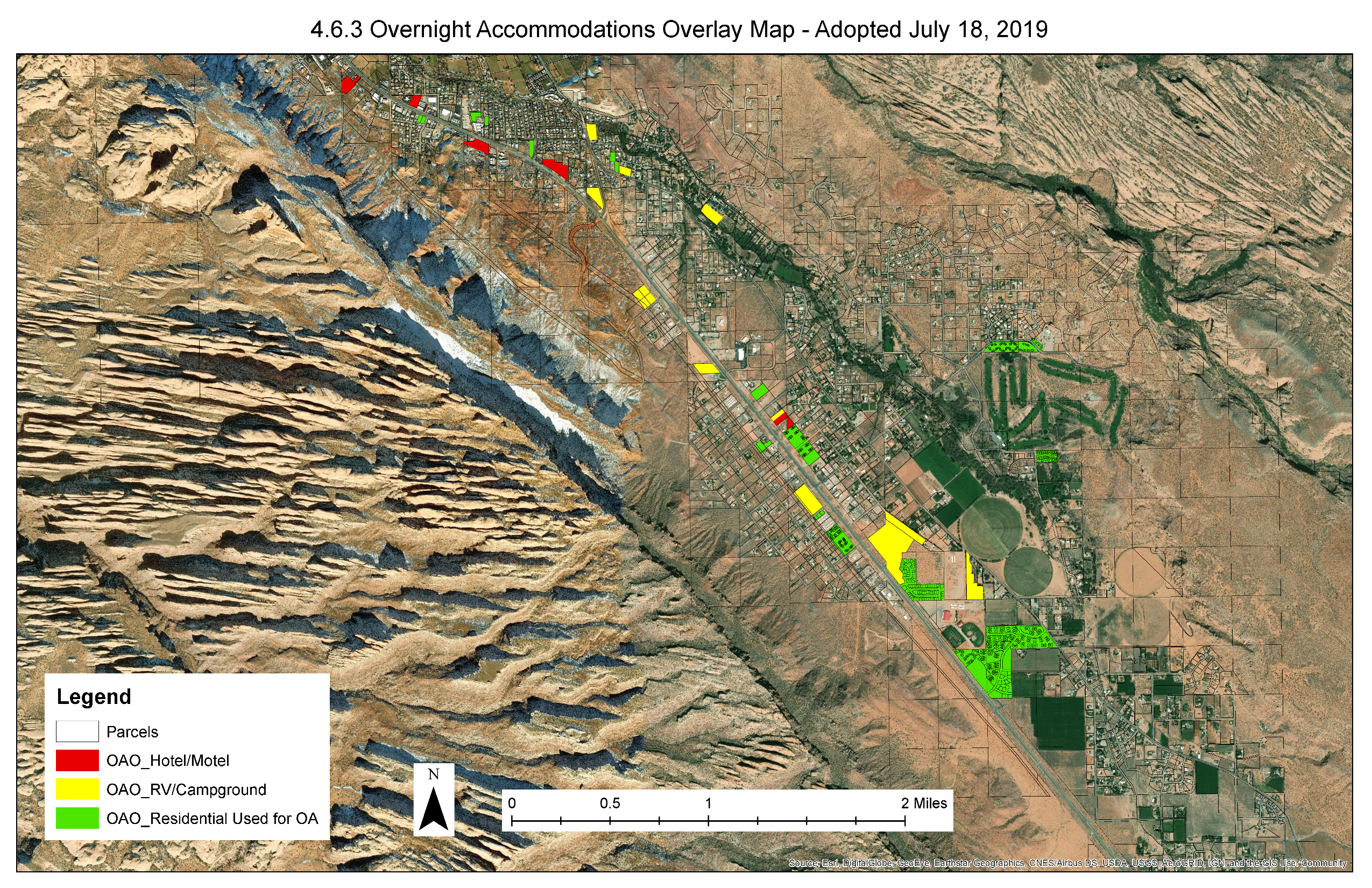
4.6 -OAO, Overnight Accommodations Overlay Districts
4.6.1 Purpose
The -OAO, Overnight Accommodations Overlay Districts are overlay districts intended to designate subdivisions and developments within which overnight accommodations are permitted. Overnight accommodations, while part of the Grand County economy and tradition, are not appropriate in all zone districts and parts of the County. -OAO Districts should be applied only to parcel(s) planned or historically used primarily for such use and activity, accessible directly by an arterial or collector street, and where appropriate and compatible with adjacent land uses and neighborhoods.
The -OAO Districts ensure that overnight accommodations are designed and developed in a manner that addresses the impacts and the increased service needs they generate, including but not limited to traffic, employee housing, natural resources (e.g., land and water), sewerage, law enforcement, and emergency medical services. The -OAO Districts also ensure that Grand County maintains a healthy amount of developable commercial land and mix of commercial uses that support a diverse economy. The -OAO Districts should be applied to ensure that new and redeveloped projects result in tangible community benefits through the application of creative design, the incorporation and support for mixed uses both on site and elsewhere in the community, and through the provision and support for public uses and spaces to provide a balanced community structure. [Ord. 607, 2020; Ord. 595, 2019.]
4.6.2 Applicability
The regulations set forth in this section may be applied to real property located within the -OAO boundaries shown on Exhibit A to the ordinance codified in this section upon application to and approval by the County Commission pursuant to the provisions herein.
When approving or denying an -OAO District application, the Commission shall consider and make findings related to the impact of the proposed development on:
A. Grand County’s effort to achieve or maintain a balanced ratio of mixed uses in the County, including residential, lodging, and commercial uses; and
1. In determining what constitutes a balanced ratio of mixed uses, the County Commission shall consider the following factors:
a. Grand County’s early 2019 development ratio of 1.4 overnight accommodation units to one primary residential unit;
b. Carrying capacity analyses or additional studies specific to Grand County; and
c. The considerations of interest in Section 4.6.7C.2.g(1).
Upon approval, and subject to all applicable zoning regulations, the development agreement and master plan shall control development of the applicable real property.
[Ord. 607, 2020; Ord. 595, 2019.]
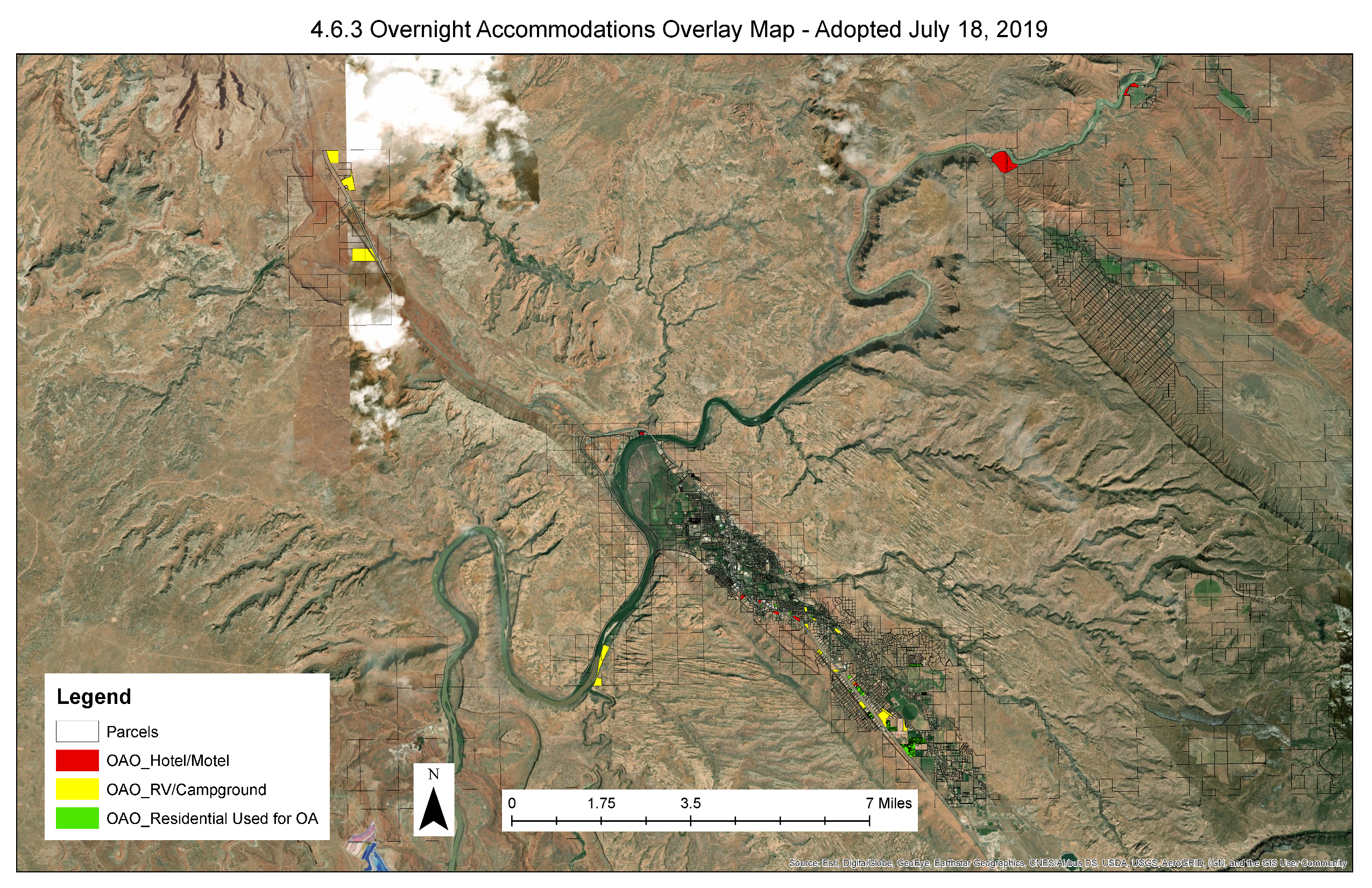
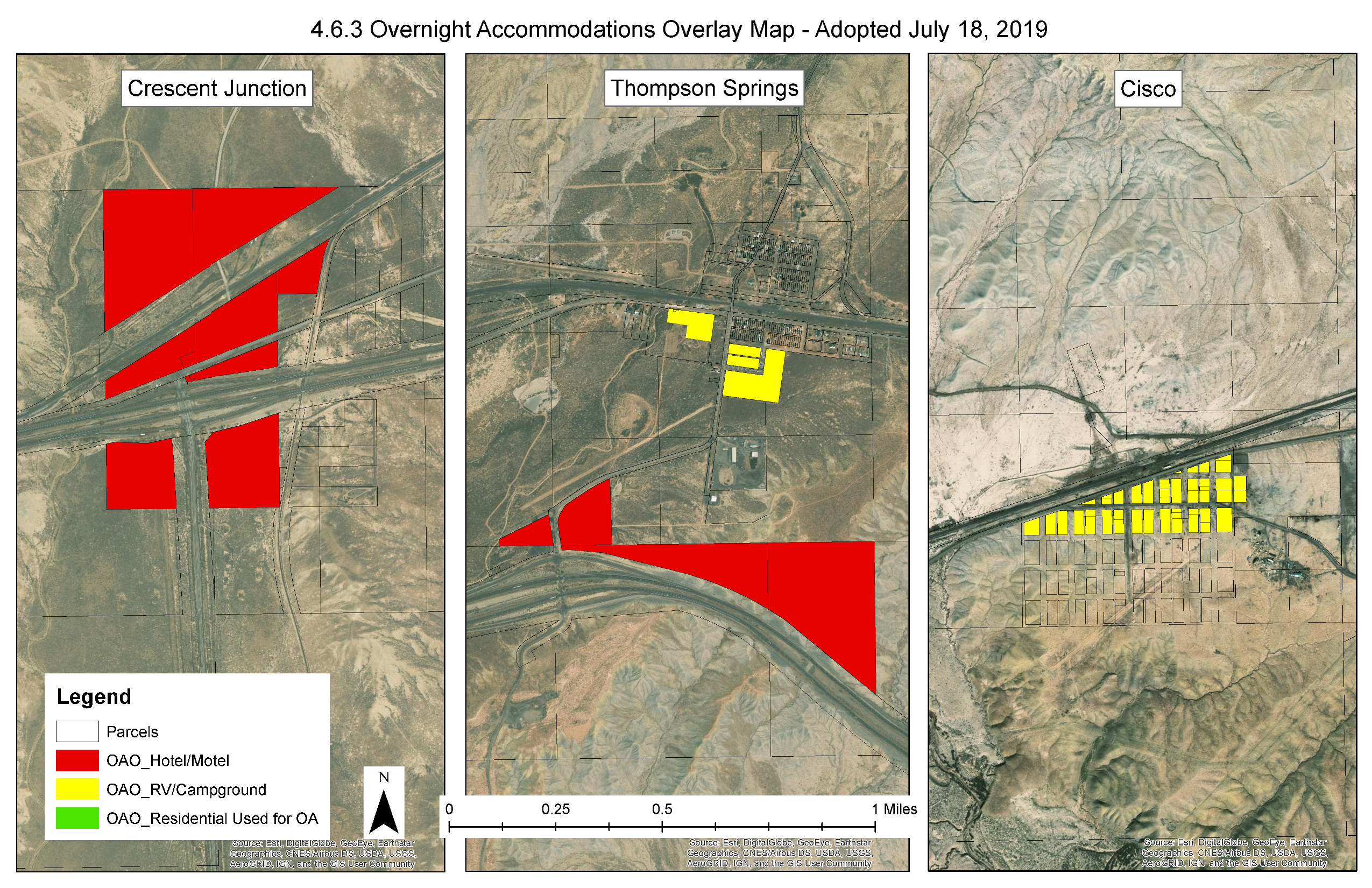
4.6.3 Identification on Zoning Maps
Approved -OAO Districts and developments shall be indicated on the official Zoning Map.
[Ord. 595, 2019.]
4.6.4 Allowed Uses
Uses allowed in the -OAO Districts shall be as specified in the underlying base district together with permissible overnight accommodations occupied for time periods of less than 30 days. Accordingly, overnight accommodations developments shall be allowed to incorporate new residential and commercial uses otherwise allowed by the underlying base district. Existing overnight accommodations developments shall not be allowed to expand the number of spaces, lots, or units for which they were originally approved to use as overnight accommodations. [Ord. 595, 2019.]
4.6.5 Design Standards in -OAO Districts
Unless otherwise specified below, all development in an -OAO District shall comply with the design standards of the underlying zoning district and this Section 4.6, as amended.
A. Energy
1. OAO developments in the OAO-Hotel/Motel District and residential units used for overnight accommodations in the OAO-Residential District and all structures owned or managed by OAO developments in the OAO-RV/Campground District shall produce 80 percent of their energy needs on site through solar, geothermal, or other renewable energy sources.
2. OAO developments are encouraged to purchase their remaining energy needs through renewable energy programs and credits.
3. OAO developments may meet these energy requirements by submitting a certification through the Green Building Council (LEED Zero or better), Living Building Challenge, Net Zero Building Certification, or other established industry standard.
4. OAO developments shall submit an annual report demonstrating compliance with the above standards by notarized affidavit to the County on or before January 31st each year. Failure to comply with this requirement could result in the loss of a business license.
B. Water
1. OAO developments shall install the largest feasible rainwater catchment system based on rooftop size, layout, and an analysis of average storm events, as demonstrated by a stamped engineering plan; provided, however, that developers shall not be required to install systems that would generate more water than is needed to satisfy a development’s outdoor water/landscaping irrigation needs.
a. OAO developments shall use the water for beneficial on-site uses such as reducing the use of culinary water for landscaping irrigation. Unless exempt, developers shall register their capture and storage of precipitation with the State of Utah Division of Water Rights prior to placing the water to beneficial use.
2. OAO developments shall include greywater reuse systems for all shared or group shower or laundry facilities and use the greywater for beneficial on-site uses such as reducing the use of culinary water for landscaping irrigation.
3. OAO developments shall utilize drought-resistant, water-wise, and xeriscape landscaping design principles. Turf grass may not exceed 10 percent of the landscaped area or 3,000 square feet, whichever is less.
4. To the maximum extent possible, OAO developments shall utilize bio-retention and bio-infiltration systems to manage storm water runoff.
C. Transportation
1. OAO developments shall incorporate into their subdivision plat or site plan the following transportation infrastructure:
a. Space to accommodate a transit or shuttle stop.
b. OAO hotel/motel developments shall provide covered, lockable bike storage at a rate of one space per two lodging units.
c. Active transportation and non-motorized trail easements dedicated to the public where identified in the Grand County Non-Motorized Trails Master Plan.
d. Electric vehicle charging stations at the rate of two stations per the first 25 units, with one being ADA-accessible, and one station per additional 25 units.
2. OAO developments shall incorporate into their subdivision plat or site plan transportation solutions that will aim to reduce projected vehicle trips below the ITE Trip Generation Manual by 20 percent.
D. Mixed Use
1. OAO developments must comply with the assured housing requirements of Section 6.15.
E. Open Space
1. OAO developments shall incorporate into their subdivision plat or site plan the following usable, functional open space together with a public access easement at the following levels based on the size of all parcels included in the development:
a. Zero to one acre: five percent; all contiguous.
b. One to two acres: 10 percent; at least half contiguous.
c. Two to five acres: 15 percent; minimum 7,500 square feet of contiguous.
d. Five or more acres: 25 percent; minimum 7,500 square feet of contiguous.
F. Height
1. OAO developments shall be required to provide a viewshed analysis as part of their OAO application, which analyzes the impact of the proposed height and siting of structures on the visibility of surrounding landscape features.
2. Potential viewshed impacts, as determined by the viewshed analysis, shall be reasonably mitigated, which may include height and siting restrictions.
3. OAO developments may be constructed to the maximum height allowed by the underlying zone district only if the viewshed analysis is determined to show no detrimental impacts on the visibility of surrounding landscape features.
4. OAO developments shall be subject to the ridgeline standards in Section 6.9.8.
G. Density and Scale
1. Hotel/motel and residential developments used for overnight accommodations shall have a maximum building size of 15,000 square feet and 35 bedrooms.
2. Hotel/motel and residential developments used for overnight accommodations shall have a maximum project size of 50,000 square feet and 60 bedrooms.
3. RV/campground developments shall be limited to a maximum of 60 spaces.
H. Site Configuration
1. Primary uses must face the fronting roadway. Where parcel or site configurations create challenges for meeting this standard, OAO developers shall present alternative use and design features that create an appealing and active interface with the fronting roadway.
2. All development must fit the topography of the property. No mass grading or grading of a flat building envelope (building must step with terrain) is permitted.
3. Additional off-street parking may be required as necessary to mitigate impacts on adjacent land uses and neighborhoods as determined by the Zoning Administrator and County Engineer.
I. Building Design
1. No facade or building wall shall exceed 60 linear feet. More than five feet shift in vertical and horizontal facade is required for each 30 linear feet.
2. Building design shall vary between vertical facade divisions and from adjacent buildings by the type of dominant material or color, scale, or orientation of that material and at least two of the following:
a. The proportion of recesses and projections;
b. The location of the entrance and window placement, unless storefronts are utilized;
c. Roof type, plane, or material, unless otherwise stated in the building type requirements.
3. No rectangular area greater than 30 percent of a building story’s facade, as measured from floor to floor, may be windowless, and no horizontal segment of a building story’s facade greater than 15 feet in width may be windowless, unless otherwise approved. An exception may be considered if the wall area is to be used to display public art (not a sign).
4. Air conditioning units and similar mechanical requirements should be avoided on rooftop locations, and fully screened from view when unavoidable. Rooftop parking shall be shielded from view and integrated into the overall building design.
5. Plastic or vinyl awnings are not permitted. Awning types and colors for each building face shall be coordinated. Awnings must be of solar stabilized materials.
6. If installed, shutters, whether functional or not, shall be sized for the windows. If closed, the shutters shall not be too small for complete coverage of the window. Shutters shall be wood or other durable material.
J. Materials and Colors
1. OAO developments shall be constructed of durable primary materials such as stone, brick and adobe-type materials; wood lap siding; fiber cement board lapped, shingled, or panel; metal siding; glass; or engineered stone. Aside from solar panels or other infrastructure related to energy efficiency and water use/reuse, OAO developments shall utilize nonreflective materials.
2. OAO developments shall utilize earth tone colors that are complementary to the surrounding landscape and visual backdrops. Exceptions shall be allowed for public art.
[Ord. 607, 2020; Ord. 595, 2019.]
4.6.6 Use and Occupancy Standards
In addition to the requirements of Section 4.6.5, all principal and accessory structures in an OAO development shall comply with the following use and occupancy standards requirements. An individual land use permit and business license shall be required for each RV/campground, hotel/motel, or dwelling unit rented for time periods of less than 30 days.
A. Bed and Breakfasts
Bed and breakfasts shall comply with the standards of this section:
1. Bed and breakfast facilities shall meet the minimum performance standards for off-street parking as specified in Section 6.1, including reasonably expected extraordinary parking demands.
a. On-street parking by bed and breakfast guests is expressly prohibited;
b. Driveways and other access ways to the principal structure do not satisfy the off-street parking requirements for bed and breakfast guests.
2. One sign shall be allowed, in accordance with the requirements of Section 6.5, Signs.
3. Information for emergencies must be made available to guests.
4. The zoning administrator may revoke a bed and breakfast permit if it is determined that:
a. The applicant has misrepresented any material fact on his or her application or supporting materials;
b. The bed and breakfast fails or ceases to comply with applicable standards, conditions or criteria for issuance of a permit;
c. The operation of the bed and breakfast violates any statute, law, ordinance or regulation; and/or
d. The operation of the bed and breakfast constitutes a nuisance or poses a real or potential threat to the health, safety or welfare of the public.
B. Dude Ranch or Destination Resort
Dude ranches and destination resorts shall be permitted in the OAO-Hotel/Motel Districts. All dude ranches or destination resorts shall comply with the standards of this section:
1. Accessory facilities may include restaurants, gift shops, employee housing, equestrian facilities and health spas;
2. Provide adequate public facilities and services based on the type and scope of the development proposed; a private water and/or sewerage system may be required where the capacity of available public water system and/or sewage treatment system is insufficient to serve current zoned density;
3. Provide public trail and/or road right-of-way dedications as necessary to maintain historic access to public lands;
4. Provide complete food service for all guests;
5. Provide a recreational amenity package suitable for the scale of the project;
6. Signs allowed on site shall comply with the requirements of Section 6.5; provided, however, that:
a. Maximum allowable signage, defined as the aggregate total square footage of signs on site, shall be as determined by the Planning Commission up to a maximum of 192 square feet; provided, that no individual sign shall be larger than 92 square feet; and
b. Signs that are not visible from off site shall not be considered in the maximum allowable signage;
7. The density of accommodations units shall be limited to one per two and one-half acres, and the average size of all accommodations units shall not exceed 600 square feet; provided, however, that the County may permit bonus density up to one unit per acre and/or bonus average unit size, where the County specifically finds that a proposed development will provide significant and substantial public benefit, as compared to alternative uses for the subject property, by exceeding county standards with respect to:
a. Protection of sensitive lands on the site;
b. Dedication of viewshed easements across the property from high public use areas;
c. Dedication of 80 percent or more of the site as open space;
d. Protection and enhancement of wildlife habitat; and
e. Diversification of the local economy;
8. Employee housing shall be provided and such housing shall be restricted in accordance with the requirements of Section 6.14.
C. Recreational Vehicle, Campground, and Travel Trailer Park
Recreational vehicle, campground, and travel trailer parks shall comply with the following standards:
1. Each space may be occupied only by persons using “park model” units, travel trailers, truck campers, small cabins (traditional KOA-style), and tents for overnight, short duration, or seasonal camping;
2. Each space RV/travel trailer space shall be at least 1,200 square feet in area;
3. Each cabin or tent space shall be at least 800 square feet in area;
4. Each space shall be at least 30 feet in width;
5. Each park shall be served by public water and sewer facilities;
6. No space shall be located more than 200 feet from a water and sewage service building;
7. The County may require landscaping and screening pursuant to the provisions of Section 6.4, Landscaping and Screening; and
8. One tree of a species suitable for the area shall be provided for each two spaces, and shall be located in close proximity to those spaces. (Existing trees on the site may be used to satisfy this requirement.)
D. Residential Units Used for Overnight Accommodations
Residential units used for overnight accommodations shall comply with the following requirements:
1. Each residential dwelling unit used for overnight accommodations shall require its own land use permit and business license even when multiple units are owned or managed by one entity.
2. Such units shall be managed by Utah-licensed property management agents or companies with a local Grand County representative, and shall collect and pay all applicable taxes, including but not limited to the transient room tax (TRT).
3. Additional off-street parking may be required as necessary to mitigate impacts on adjacent land uses and neighborhoods.
4. Properties used for overnight accommodations shall have direct access to an arterial or collector street.
5. Current contact information for property owners or management agencies or companies shall be posted in an accessible location outside such units or project.
[Ord. 607, 2020; Ord. 595, 2019.]
4.6.7 -OAO District Application
A. Preapplication Conference. Prior to submission of an -OAO District application, as defined in this section, the developer or subdivider shall meet with the Community Development Director or their designee(s), including other County staff deemed desirable or necessary by the Community Development Director, to discuss the procedures, standards, and regulations hereunder. Uses allowed in the -OAO Districts shall comply with the use-specific standards of Article 3 and development standards of Articles 6 and 7.
B. Procedure. An -OAO District application shall be reviewed and approved in accordance with the procedures of Section 9.2, Text and Zoning Map Amendments (Rezonings), and shall be considered to be a Zoning Map amendment.
C. Application. A developer or subdivider shall submit an -OAO District application with the information contained in Section 9.2.3 together with a development agreement, master plan, and conceptual site plan as follows:
1. The development agreement shall include the following information:
a. Legal description of the property;
b. Narrative summarizing the proposed development of the property by gross acre; number of lots or units, common area and open space acreage, overall character and architectural style, and other related development features as proposed by the developer or requested by the County;
c. All other required components of the development agreement outlined in Section 6.15, Assured Housing Requirements; and
d. Method of compliance with Section 6.15, Assured Housing Requirements, which shall include a stated fee in lieu amount or number of units to be constructed.
2. The master plan shall include the following information:
a. Legal description of the property;
b. Identification of all proposed land uses including accommodations and nonaccommodations uses;
c. Number and location of lots or units to be developed on the property;
d. Identification of site planning features designed to ensure compatibility and a seamless transition between proposed overnight accommodations development and surrounding neighborhoods or site conditions;
e. A map and description of sensitive lands within or adjacent to the proposed development and how they will be addressed, including but not necessarily limited to the following:
(1) Public drinking water supply watersheds (recharge areas for the aquifer in the Glen Canyon formation);
(2) Floodplains and riparian habitats;
(3) Slopes in excess of 30 percent; and
(4) Significant geological, biological, and archaeological sites;
f. Documentation of the specific utilities and infrastructure that are designed and installed to conserve limited natural resources such as water. Examples (for water resources) include preparation of a water use master plan for the project, the incorporation of gray-water reuse systems, implementation of water conserving landscapes, installation of real-time water monitoring systems, and the incorporation of water-efficient fixtures;
g. A narrative that includes:
(1) A description, stated with specificity, of how the proposed development impacts or benefits the following considerations of interest to Grand County and how any such impact shall be addressed or mitigated:
i. Economic diversification;
ii. Job creation;
iii. Increased wages;
iv. Community aesthetics;
v. Civic and open space;
vi. County infrastructure such as roads, water, sewer, and storm water;
vii. Public services such as law enforcement and emergency medical services;
viii. Traffic, in quantity and circulation;
ix. Water resources, in quantity and quality;
x. Housing demand;
xi. Crowding or congestion in national parks and other nearby public lands.
(2) A description, stated with specificity, of additional beneficial public services and goods the proposed development provides to the community.
(3) An analysis that compares the stated community benefit(s) with the proposed impact(s).
3. The conceptual site plan shall include the information required under Sections 9.17.3A through N. [Ord. 607, 2020.]
D. Recordation. The developer or subdivider shall record the development agreement and master plan in the real property records of Grand County, Utah, prior to recordation of a final plat approved hereunder or issuance of a building permit for any unit within a site plan approved hereunder. Once approved, the development agreement and master plan may not be amended or modified without reapplication to the County.
E. Effect. Review and consideration of an -OAO District application is a discretionary legislative decision. Further, approval of an -OAO District application does not constitute site plan, preliminary plat, or final plat approval. Rather, such approval shall be deemed approval of permission to develop under the standards of this section and the master plan.
F. Lapse of Approval. The -OAO District approval shall automatically expire and be void unless the County approves and developer records a site plan or final plat for the overnight accommodations development in accordance with Section 9.5 or 9.17 within 24 months of the date of -OAO District approval.
G. Conflict. In the event of conflict between the provisions of Section 9.2 and this Section 4.6.7, this section shall control.
[Ord. 622, 2021; Ord. 595, 2019.]
4.7 High Density Housing Overlay Districts Revised 12/23
4.7.1 Purpose Revised 12/23
The High Density Housing Overlay Districts (“HDHO Districts”) are designed to provide for modification of the otherwise applicable development standards of the underlying base district as specified in Articles 2 and 5, in order to accomplish one or more of the following purposes:
A. Facilitating the provision of new housing units used for primary residential occupancy by actively employed households;
B. Achieving the goals of the housing element of the County’s General Plan;
C. Implementing the policies and goals of the housing element of the County’s General Plan;
D. Encouraging the development of new high quality housing units by assisting both the public and private sector in making the provision of these units economically viable; and
E. Encouraging the provision of primary residential housing through the combination of multiple-family and single-family residential zoning districts within the County where the residential housing projects are determined to be feasible and are consistent with the County’s General Plan.
[Ord. 687, 2023; Ord. 591, 2019.]
4.7.2 Applicability Revised 12/23
The regulations set forth in this section may be applied to real property located within the HDHO boundaries, as shown in Exhibit A attached to the ordinance codified in this section, upon application to and approval by the County Commission pursuant to the provisions herein. Upon approval, the HDHO District zoning, development agreement, and master plan shall control development of the property.
[Ord. 687, 2023; Ord. 591, 2019.]
4.7.3 Definitions Revised 12/23
A. “Active employment household” or “actively employed household” means a household with at least one adult who meets one of the following criteria; provided, however, where there are unrelated individuals living together in one household, at least 50 percent of all the adults comprising the household shall meet one of the following criteria:
1. A full-time (aggregate of 30 hours of employment per week) employee of an entity or entities located within the 84532 zip code; or
2. An owner or owner’s representative of a business or entity with a primary place of business within Grand County; or
3. A full-time (aggregate of 30 hours of employment per week for nine months out of each calendar year) worker who is self-employed or works out of their home must provide their entire list of clients/workload so that it can be verified that a minimum of 75 percent of their work/clients are based within Grand County, or provide proof of at least five years of residency within the 84532 zip code and verification of annual gross household income being less than 160 percent of the Area Median Income (AMI) for Grand County, per current HUD calculation.
4. A person who is unable to work or does not have a work history required under subsections A.1 through 3 of this section due to a disability; or
5. A retiree with a work history required under subsections A.1 through 3 of this section for the five years prior to retirement.
B. “Developer” means any person, firm, partnership, association, joint venture, corporation, or any entity or combination of entities, which seeks approval of an application for an HDHO development.
C. “Development agreement” means a development agreement and deed restriction, which is a contract between Grand County and a developer or subdivider, which is recorded as an encumbrance upon the property to ensure compliance hereunder. A development agreement shall run with the land and be binding upon the parties and their successors in title, as provided by its terms.
D. “High Density Housing Overlay District” or “HDHO District” means a zoning district applied to the property that benefits from a higher density than that allowed under the existing underlying zoning designation, which attendant increased density encourages the provision of new housing units used for primary residential occupancy as further described in this section.
E. “High Density Housing Overlay development” or “HDHO development” means a subdivision or site plan approved within an HDHO District in which at least 80 percent of the lots or units developed on the property are restricted for primary residential housing occupied by actively employed households.
F. “High Density Housing Overlay lot” or “HDHO lot” is a lot restricted for primary residential housing occupied by actively employed households that otherwise meet the requirements of this section.
G. “HDHO lots or units” or “HDHO lots and units” shall refer to HDHO lots and/or HDHO units.
H. “High Density Housing Overlay unit” or “HDHO unit” is a dwelling unit restricted for primary residential housing occupied by actively employed households that otherwise meet the requirements of this section.
I. “Household” means one adult living alone, two or more adults related to each other by blood, marriage, or another legally recognized relationship, or a maximum of five unrelated adults residing in the same residence.
J. “Master plan” means a planning document which guides development of the property based on the County’s planning goals, existing development, and physical characteristics of the particular HDHO development. A master plan shall be recorded, run with the land, and be binding upon the parties and their successors in title, as provided by its terms.
K. “Primary resident” means an adult that meets the “primary residential occupancy” requirement.
L. “Primary residential housing” or “primary residential development” shall have the same meaning as “high density housing development,” which terms may be used interchangeably throughout this section.
M. “Primary residential occupancy” means the owner of record occupying the dwelling unit for a minimum of nine months out of any 12-month period or an occupant of the dwelling unit through a lease term no shorter than six months out of any 12-month period.
N. “Property” means a specific parcel of real property upon which an HDHO District is applied.
O. “Residency” means living in the 84532 zip code without gaps of more than three months at a time, and having proof of one’s place of residence in the 84532 zip code via one of the following pieces of documentation:
1. Rental lease agreement for a property within the 84532 zip code.
2. Income tax return or W-2 with name and address demonstrating residence in the 84532 zip code.
3. Paystub or letter from employer of a business located within the 84532 zip code.
P. “Subdivider” means any person creating a subdivision and offering lots for sale to the public.
[Ord. 687, 2023; Ord. 591, 2019.]
4.7.4 Permitted Uses
The following uses are permitted within an HDHO development upon the County Commission’s approval of application of an HDHO District to a specific parcel:
A. Residential developments at a density greater than normally permitted by the underlying zoning district as described in the table below, when a subdivider or developer ensures a minimum of 80 percent of lots or units developed on the property are deed restricted for primary residential occupancy for actively employed households. HDHO lots and units may be owner-occupied or renter-occupied as long as the residents meet the occupancy and active employment requirements of this subsection A. The maximum density (units/acre) limit shall be based on a calculation that includes all existing and all new units on the land area that is being included in the calculation. Residential development qualifying for greater density pursuant to the provisions of this section shall be permitted to obtain such density by constructing residential housing types not otherwise allowed in the underlying zoning district. For example, multifamily units may be constructed in a single-family residential zone.
|
High Density Housing (HDH) District |
Maximum Density |
|---|---|
|
HDH 35a |
35 lots or units per acre |
|
HDH 35b |
35 lots or units per acre |
|
HDH 25 |
25 lots or units per acre |
|
HDH 15 |
15 lots or units per acre |
|
HDH 10 |
10 lots or units per acre |
|
HDH 5 |
5 lots or units per acre |
B. Accessory uses or structures incidental to the principally permitted use pursuant to Section 3.3. Any accessory dwelling unit permitted under Section 3.3 in an HDHO development shall meet the occupancy and active employment requirements of subsection A of this section.
[Ord. 591, 2019.]
4.7.5 Development Standards
A. Eligibility. In order to reduce costs associated with the development and construction of primary residential housing, the property development standards set forth in subsection B of this section are established for and shall apply to all HDHO developments within the HDHO Districts upon approval of a site plan or preliminary plat approval.
B. Property Development Standards. The following development standards shall apply to HDHO developments within the HDHO Districts:
1. General Design Standards. The development shall be designed and developed in a manner compatible with and complementary to existing and potential development in the immediate vicinity of the development site. Site planning on the perimeter shall provide for protection of the property from adverse surrounding influences and shall protect surrounding areas from potentially adverse influences from the property. To the greatest extent possible, the design of the development shall promote privacy for residents and neighbors, security, and use of passive solar heating and cooling through proper placement of walls, windows, and landscaping.
2. Minimum Design Standards. Minimum design standards are included to ensure a high degree of quality in the development of HDHO lots and units. The following design standards shall apply to a development that utilizes the density increases allowed by this section:
a. Sidewalks shall be installed along all street frontages where otherwise required by this LUC.
b. Screening Requirements.
(1) Outdoor Storage Screening. All outdoor storage areas for materials, trash, mechanical equipment, vehicles, or other similar items shall follow the standards outlined in Section 6.4.3.
(2) Parking Lot Screening. Parking lot screening must be provided between an off-street parking area containing six or more parking spaces and either 1) a different zoning district or 2) a public street, and shall:
i. Be provided within 10 feet of the perimeter of the parking lot to be screened, except for parking lots adjacent to rain gardens/bioretention systems, other landscape features, or where screening may negatively impact the traffic sight distance (as defined by the American Association of State Highway and Transportation Officials (AASHTO) and verified by the County Engineer);
ii. Be not less than 80 percent opaque and be a minimum of three feet in height as measured from the highest finished adjacent grade of the parking area. When shrubs are used to provide the screen, such shrubs must be at least two feet tall at planting and anticipated to grow to at least three feet tall at maturity;
iii. Not interfere with driver or pedestrian visibility for vehicles entering or exiting the premises;
iv. Utilize plants found in Section 6.4.3F, where required;
v. Consist of at least two of the following:
(A) A compact hedge of evergreen or densely twigged deciduous shrubs spaced to ensure closure into a solid hedge at maturity.
(B) A berm with plantings as described above.
(C) Transit shelters, benches, bicycle racks, and similar features may be integrated as a part of the screen.
(D) Fencing may be integrated as part of the screen. All wood fencing shall be stained and sealed with a weatherproof product;
vi. Be equipped with an irrigation system adequate for establishing and maintaining the plant materials within it.
c. Parking Island Design. Off-street parking areas with at least 25 parking stalls shall contain interior landscaped islands. Such islands shall be bounded by a raised concrete curb, pervious curbing, or an approved equivalent and shall contain mulch to retain soil moisture. This provision shall not apply to parking structures. Landscaped parking lot islands shall:
(1) Be located at the beginning and end of each parking row and shall contain a minimum of 180 square feet and a minimum width of nine feet;
(2) Include at least one tree per island;
(3) Incorporate shrubs, perennials, and ornamental grasses, where required;
(4) Be prepared with topsoil to a depth of two feet and improved to ensure adequate drainage, nutrient, and moisture retention levels for the establishment of plantings; and
(5) Be equipped with an irrigation system adequate for establishing and maintaining the plant materials within it.
d. Building Exterior Facade Standards.
(1) Exterior finishes may be of wood, masonry, stone, stucco, HDO board or other high quality material permitted by the building code, but shall not utilize vinyl siding; cedar or wood shakes; highly reflective, shiny, or mirror-like materials; or exposed plywood or particle board.
(2) Buildings shall utilize at least two of the following design features to provide visual relief along the front of the residence:
i. Projections, recessions, or reveals such as, but not limited to, columns, pilasters, cornices, and bay windows.
ii. Dormers.
iii. Gables.
iv. Recessed entries, a minimum of three feet deep.
v. Covered front porches.
vi. Cupolas.
vii. Architectural pillars or posts.
viii. Quoins.
ix. Corbeling on wall.
x. Decorative lintel.
xi. Incorporation of brick or stone on at least 25 percent of front surface area.
e. Where HDHO units may be placed on the same lot as current or future temporary or short-term accommodations, dedicated HDHO units shall be clustered together so as to minimize the exposure of residents to temporary guests. In all other developments, where temporary or short-term accommodations units do not exist and cannot exist due to zoning restrictions, dedicated HDHO units shall be dispersed throughout the residential development.
f. Where there is a combination of commercial and residential uses, the commercial uses shall front along the highest road designation. Residential development shall be located behind commercial development or on upper floors above commercial development.
g. The County Commission may waive, or modify, any, or all, of these requirements when the Commission finds it is infeasible to comply due to physical or other constraints on the lot.
3. Minimum Building Site Area and Lot Width. There shall be no minimum building site area, minimum lot width, or maximum lot coverage requirements for individual lots or individual dwelling sites in a HDHO development. However, the building site area lot widths and lot coverage percentages shall be designated on a preliminary plat or site plan pursuant to Section 4.7.9.
4. Density. Overall density of site development within an HDHO District shall not exceed the limits established in Section 4.7.4.
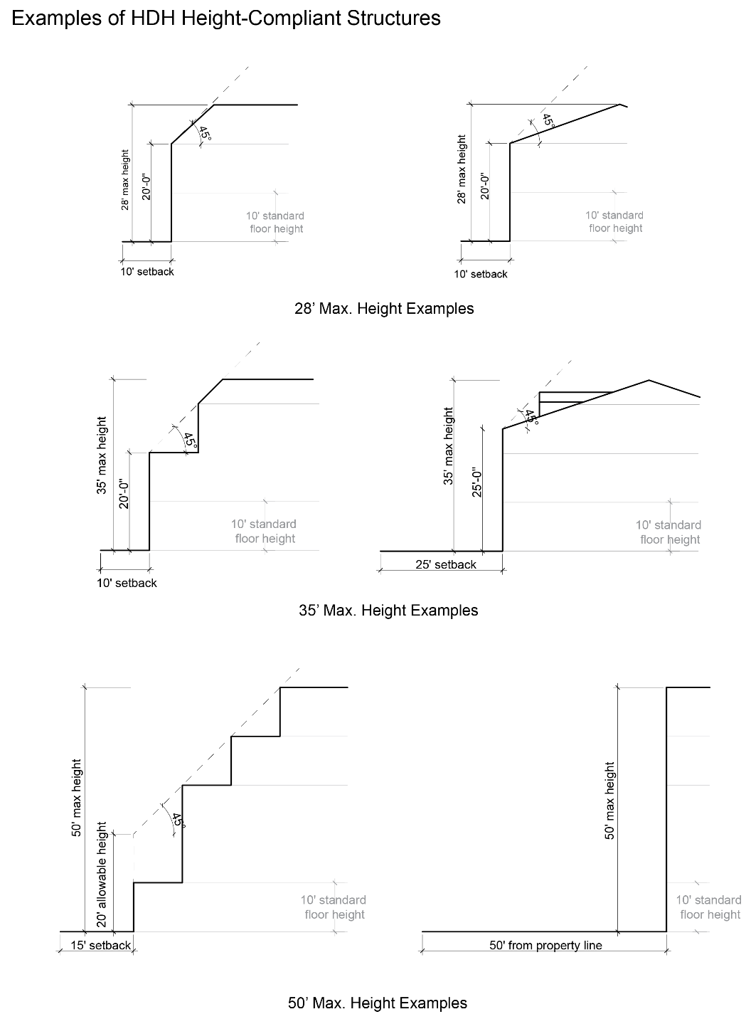
5. Building Height.
a. Maximum building heights shall not exceed the limits defined in the underlying zone district except that buildings constructed in the HDHO 35b District shall not exceed four stories or 42 feet in height.
b. To the maximum extent possible, building heights and locations shall minimize shading and interruption of solar access to adjacent properties with existing residential structures or commercial agricultural operations.
c. All structures shall conform to the ridgeline standards of Section 6.9.8.
d. Structures built within an HDHO development must comply with the setback and buffer requirements of the underlying zone. The maximum height of the building at the exterior wall shall be the greater of:
(1) Twenty feet.
(2) The building’s setback at that point.
e. From the exterior wall, the building’s height may increase to its maximum height at a rate not greater than a 45 degree angle from the maximum allowable height of the exterior wall.
6. Setbacks. The minimum setbacks from the lot line of the development shall be determined by the buffer requirements of Section 5.4.1B and the compatibility standards of Section 6.10.
7. Parking.
a. Number of Spaces Required.
(1) For every single-family or two-family dwelling, there shall be provided at least two off-street parking spaces for each unit. Parking spaces provided in a garage or carport may count towards the minimum requirement.
(2) For every attached multifamily dwelling, off-street parking spaces shall be provided in accordance with Section 6.1.4:
|
Multifamily dwellings |
Efficiency and one-bedroom |
1.5 per dwelling unit |
|
Two-bedroom |
1.75 per dwelling unit |
|
|
Three-bedroom and larger |
2.0 per dwelling unit |
b. Parking Design Requirements.
(1) Parking areas for single-family or two-family dwellings need not be paved.
(2) Parking areas for attached multifamily dwellings shall be subject to the off-street requirements outlined in Section 6.1.7.
(3) Uncovered surface parking may be permitted in the rear and side setbacks but is not permitted in the front or street-side setback.
(4) Garages, carports, and individual locking storage units are subject to the setback standards outlined in Section 5.4.1.
(5) Required spaces for multifamily developments equal to or greater than five units shall be covered in a carport or a garage except that for multifamily dwellings with four or fewer units, parking spaces can be uncovered.
8. Minimum Standards of Physical Condition. Each HDHO unit is required to have and maintain those minimum standards of physical conditions set forth in Exhibit B – Minimum Standards, attached to the ordinance codified in this section.
9. Streets. All public streets within or abutting the proposed planned development shall be dedicated and improved to County specifications for the particular classification of street.
10. Signs. Signs shall be permitted only to the extent allowed under Section 6.5, Signs, and must be approved by the Planning and Zoning Administrator.
11. Construction Timing. The HDHO units shall be ready for occupancy no later than the date of the initial or temporary occupancy of any unrestricted units within the development or applicable phase thereof. If the unrestricted units are developed in phases, then the HDHO units may be developed in proportion to the phasing of the unrestricted units. For example, for each unrestricted unit constructed at least four HDHO units shall be constructed.
[Ord. 591, 2019.]
4.7.6 Assurance of Primary Residential Housing and Occupancy Revised 12/23
A. General. HDHO lots and units shall be used for primary residential housing for actively employed households in perpetuity.
B. Deed Restriction. The following deed restriction shall be integrated into the development agreement, the master plan, each final plat or site plan, and each deed of conveyance:
The Property shall be used for Primary Residential Housing for Actively Employed Households as required by Grand County Land Use Code, Section 4.7, High Density Housing Overlay Districts, in perpetuity. As such, upon sale of any HDHO unit, the Title Company shall provide a Notice of Sale to HASU and the County for the purpose of verifying the buyer is an Actively Employed Household.
The Property is further subject to a Development Agreement and Master Plan recorded against the Property in the real property records of Grand County, Utah.
Grand County reserves the right to revoke, deny or suspend any permit, including a land development permit, conditional use permit, building permit, certificate of occupancy, or discretionary approval upon a violation or breach of this Deed Restriction by a record owner of any HDHO Lot or Unit in Grand County. [Ord. 615, 2020.]
C. Enforcement. In addition to other remedies preserved herein, Grand County reserves the right to revoke, deny or suspend any permit, including a land development permit, conditional use permit, building permit, certificate of occupancy, or discretionary approval upon a violation or breach of this section by a record owner of any HDHO lot or unit in Grand County.
[Ord. 687, 2023; Ord. 591, 2019.]
4.7.7 Development Incentives
A. General. As a further inducement to the development of primary residential housing beyond the relaxation and flexibility of development standards, the County, where appropriate, may also extend one or more development incentives to an HDHO development, as set forth in subsection B of this section, the selection of which shall depend on the quality, size, nature, and scope of the development being proposed. Incentives shall be targeted to improve the development design or to yield the greatest number of HDHO units, so as to permit the County to meet its estimate of additional housing needs and the goals of the housing element of the County’s General Plan.
B. Additional Development Incentives. The County may also offer impact fee deferrals or waivers, property tax abatements, or direct financial contributions should the County Commission determine that such incentives are warranted and in the best interest of the County.
[Ord. 591, 2019.]
4.7.8 HDHO District Application
A. Preapplication Conference. Prior to submission of an HDHO District application, as defined in this section, the developer or subdivider shall meet with the Community Development Director or their designee(s), including other County staff deemed desirable or necessary by the Community Development Director, to discuss the procedures, standards, and regulations hereunder.
B. Procedure. An HDHO District application shall be reviewed and approved in accordance with the procedures of Section 9.2, Text and Zoning Map Amendments (Rezonings), and shall be considered to be a zoning map amendment.
C. Application. A developer or subdivider shall submit an HDHO District application with the information contained in Section 9.2.3 together with a development agreement, master plan, and conceptual site plan as follows:
1. The development agreement shall include the following information:
a. Legal description of the property;
b. Narrative summarizing the proposed development of the property by gross acre, number of lots or units, common area and open space acreage, overall character and architectural style, and other related development features as proposed by the developer or requested by the County;
c. Percentage of HDHO lots or units to be developed on the property; and
d. Deed restriction required by Section 4.7.6B.
2. The master plan shall include the following information:
a. Legal description of the property;
b. Number and location of lots or units to be developed on the property;
c. Percentage of HDHO lots or units to be developed on the property, including designation of the specific HDHO lots or units in accordance with Section 4.7.4; and
d. Identification of site planning features designed to ensure compatibility between proposed HDHO development and surrounding neighborhoods and land use.
3. The conceptual site plan shall include the information required under Sections 9.17.3A through N.
D. Recordation. The developer or subdivider shall record the development agreement and master plan in the real property records of Grand County, Utah, prior to recordation of a final plat approved hereunder or issuance of a building permit for any unit within a site plan approved hereunder. Once approved, the development agreement and master plan may not be amended or modified without reapplication to the County.
E. Effect. Review and consideration of an HDHO District application is a discretionary legislative decision. Further, approval of an HDHO District application does not constitute site plan, preliminary plat, or final plat approval. Rather, such approval shall be deemed approval of permission to develop under the standards of this section and the master plan.
F. Lapse of Approval. The HDHO District approval shall automatically expire and be void unless the County approves and developer records a site plan or final plat for the HDHO development in accordance with Sections 4.7.9 and 9.5 within 24 months of the date of HDHO District approval.
G. Conflict. In the event of conflict between the provisions of Section 9.2 and this Section 4.7.8, this section shall control.
[Ord. 622, 2021; Ord. 591, 2019.]
4.7.9 HDHO Development Plat and Site Plan Approval
A. Application Procedure. Review of an HDHO development plat or site plan is an administrative decision, which shall be consistent with the County’s prior legislative approval of an HDHO District, the development agreement, and the master plan.
B. HDHO Development Preliminary Plat and Final Plat. Each subdivider shall submit and the County shall review a preliminary plat application and final plat application in accordance with Sections 9.4 and 9.5, Preliminary Plat and Final Plat, and this Section 4.7.
1. In addition to the requirements of Sections 9.4.2 and 9.5.1, Submittal Requirements, each plat shall include:
a. Designation of HDHO lots in accordance with Section 4.7.4;
b. Deed restriction as required by Section 4.7.6B.
C. HDHO Development Site Plan. Each developer of a mixed use or multifamily residential HDHO development shall submit and the County shall review a site plan application in accordance with Section 9.17, Site Plan Review, and this Section 4.7.
1. In addition to the requirements of Section 9.17.3, Submittal Requirements, each site plan shall include:
a. Designation of HDHO units in accordance with Section 4.7.4;
b. Deed restriction as required by Section 4.7.6B.
D. In the event of conflict between the provisions of Section 9.4, 9.5, or 9.17 and this Section 4.7.9, this section shall control.
[Ord. 591, 2019.]
4.7.10 Expiration of High Density Housing Ordinance
The ordinance codified in this section shall automatically expire after 300 HDHO lots or units have been approved or after two years, whichever occurs first.* A record of the number and location of HDHO lots and units approved shall be kept on file within the Community Development Department at all times. [Ord. 622, 2021; Ord. 591, 2019.]
*Code reviser’s note: The ordinance codified in this section has been retained at the request of the city.
4.7.11 Enforcement
A. Penalties for Violation. As more particularly set forth in Section 1.9, Penalties for Violation, any person, firm, entity, or corporation violating any provision or failing to comply with any provision of this section shall be guilty of a Class C misdemeanor. Without limiting the generality of the foregoing, it shall also be a Class C misdemeanor for any person, firm, entity, or corporation to sell or rent an HDHO lot or unit to a household not qualified under this section. It shall further be a Class C misdemeanor for any person, firm, entity, or corporation to provide false or materially incomplete information to the County or its designee or to a seller or lessor of an HDHO lot or unit to obtain occupancy of housing for which the person is not eligible.
B. Legal Action. In addition to the remedies set forth in Section 1.9, the County may institute any appropriate legal actions or proceedings necessary to ensure compliance with this section, including:
1. Actions to revoke, deny or suspend any permit, including a land development permit, conditional use permit, building permit, certificate of occupancy, or discretionary approval;
2. Actions to recover from any violator of this section civil fines, restitution to prevent unjust enrichment, and/or enforcement costs, including attorney fees;
3. Actions to seek judicial enforcement of such fines, restitution and costs, including judgment liens and foreclosure; and
4. Any other appropriate action for unlawful detainer, injunctive relief or damages.
[Ord. 591, 2019.]
4.7.12 Repeal/Savings Clause
Ordinance No. 584, enacted January 15, 2019, is hereby repealed; provided, however, that Ordinance No. 584 shall remain in force to authorize the arrest, prosecution, conviction, and punishment of a person who violates Ordinance No. 584 prior to the effective date of the ordinance codified in this section. [Ord. 591, 2019.]
4.7.13 Rules and Regulations* Revised 12/23
Rules and Regulations. [Ord. 687, 2023.]
*Code reviser’s note: Ord. 687 adds these provisions as Section 4.7.7. They have been editorially renumbered to avoid duplicate section numbers.
4.8 Scenic Resource Protection District
4.8.1 Purpose
The Scenic Resource Protection District (SRPD) is an overlay district intended to accomplish one or more of the following purposes:
A. Prioritize the preservation of the natural beauty and ecological quality of the gateway to Moab and facilitate the use and enjoyment of the area while providing opportunities for development that enhances the character of the area while not impeding its scenic value;
B. Recognize this area as a gateway to the valuable scenic amenities of the greater Moab area, and as an introduction to the character and outdoor ethics of the community;
C. Protect and preserve the recreational and conservation uses of the area;
D. Preserve and support the natural and ecological quality of the area including night skies, water quality and quantity, native vegetation and biome, natural quiet, and contiguous open space used as habitat by local wildlife;
E. Support development that balances conservation, recreation, and ecological goals; and
F. Fulfill the community vision for the area when the opportunity arises through smart redevelopment to protect and preserve the area for future generations to enjoy. [Ord. 621, 2021.]
4.8.2 Applicability
The SRPD shall apply to the following real property:
A. All real property leased to a private person, as defined in Section 10.2, or privately owned included in the following map (“Seven Mile Area”), for the purpose of protecting the views of the surrounding area, acknowledging the status of US Highway 191 and Utah State Route 313 as scenic byways, and protecting the view from Arches National Park into this area.
[Ord. 621, 2021.]
4.8.3 Allowed Uses
Allowed uses are governed by the underlying zone district pursuant to Article 3. The preferred zone district for parcels within the SRPD with access adjoining US Highway 191 and Utah State Route 313 is Resort Special. The preferred zone district for parcels within the SRPD without access adjoining US Highway 191 and Utah State Route 313 is Range and Grazing. [Ord. 621, 2021.]
4.8.4 Development Standards
A. Property Development Standards. The following development standards shall apply to all development of real property within the boundaries of the SRPD:
1. Height.
a. Developments shall be required to provide a viewshed analysis as part of their application, which analyzes the impact of the proposed height and siting of structures on the visibility of surrounding landscape features.
b. Potential viewshed impacts, as determined by the viewshed analysis, shall be reasonably mitigated, which may include height and siting restrictions.
c. Developments may be constructed to the maximum height allowed by the underlying zone district only if the viewshed analysis is determined to show no detrimental impacts on the visibility of surrounding landscape features.
d. Developments shall be subject to the ridgeline standards in Section 6.9.8.
2. Open Space.
a. Developments shall incorporate into their subdivision plat or site plan the following usable, functional open space together with a public access easement at the following levels based on the size of all parcels included in the development:
(1) Zero to one acre: five percent; all contiguous.
(2) One to two acres: 10 percent; at least half contiguous.
(3) Two to five acres: 15 percent; minimum 7,500 square feet contiguous.
(4) Five or more acres: 25 percent; minimum 7,500 square feet contiguous.
3. Water.
a. All developments shall install the largest feasible rainwater catchment system based on rooftop size, layout, and an analysis of average storm events, as demonstrated by a stamped engineering plan; provided, however, that developers shall not be required to install systems that would generate more water than is needed to satisfy a development’s outdoor water/landscaping irrigation needs.
b. All developments shall use the water for beneficial on-site uses such as reducing the use of culinary water for landscaping irrigation. Unless exempt, developers shall register their capture and storage of precipitation with the State of Utah Division of Water Rights prior to placing the water to beneficial use.
c. All developments shall include greywater reuse systems for all shared or group shower or laundry facilities and use the greywater for beneficial on-site uses such as reducing the use of culinary water.
d. All developments shall utilize drought-resistant, water-wise, and xeriscape landscaping design principles. Turf grass shall not be permitted.
e. To the maximum extent possible, all developments shall utilize bio-retention and bio-infiltration systems to manage stormwater runoff.
4. Site Configuration.
a. Primary uses must face the fronting roadway. Where parcel or site configurations create challenges for meeting this standard, developers shall present alternative use and design features that create an appealing and active interface with the fronting roadway.
b. All development must fit the topography of the property. No mass grading or grading of a flat building envelope (building must step with terrain) is permitted.
c. Additional off-street parking may be required as necessary to mitigate impacts on adjacent land uses and neighborhoods as determined by the Zoning Administrator and County Engineer.
5. Building Design.
a. No facade or building wall shall exceed 60 linear feet. More than five feet shift in vertical and horizontal facade is required for each 30 linear feet.
b. Building design shall vary between vertical facade divisions and from adjacent buildings by the type of dominant material or color, scale, or orientation of that material and at least two of the following:
(1) The proportion of recesses and projections;
(2) The location of the entrance and window placement, unless storefronts are utilized;
(3) Roof type, plane, or material, unless otherwise stated in the building type requirements.
c. No rectangular area greater than 30 percent of a building story’s facade, as measured from floor to floor, may be windowless, and no horizontal segment of a building story’s facade greater than 15 feet in width may be windowless, unless otherwise approved. An exception may be considered if the wall area is to be used to display public art (not a sign).
d. Air conditioning units and similar mechanical requirements should be avoided on rooftop locations, and fully screened from view when unavoidable. Rooftop parking shall be shielded from view and integrated into the overall building design.
e. Plastic or vinyl awnings are not permitted. Awning types and colors for each building face shall be coordinated. Awnings must be of solar-stabilized materials.
f. If installed, shutters, whether functional or not, shall be sized for the windows. If closed, the shutters shall not be too small for complete coverage of the window. Shutters shall be wood or other durable material.
6. Materials and Colors.
a. Developments shall be constructed of durable primary materials such as stone, brick and adobe-type materials; wood lap siding; fiber cement board lapped, shingled, or panel; metal siding; glass; or engineered stone. Aside from solar panels or other infrastructure related to energy efficiency and water use/reuse, developments shall utilize nonreflective materials.
b. Developments shall utilize earth tone colors that are complementary to the surrounding landscape and visual backdrops. Exceptions shall be allowed for public art.
7. Site Configuration.
a. Development on parcels adjacent to Highway 313 and State Route 191 must be located as far away from the roadways as possible on the parcel, and, where existing, located adjacent to existing development.
b. Where possible, development should be located such that it is the least visible from the road, using natural features to achieve this objective.
8. Skyline.
a. Physical development shall not, to the extent possible, penetrate the skyline on hillsides as seen from Highway 313 and State Route 191, unless there is no other siting alternative.
b. If a development must penetrate the skyline, attempts to obtain variances of other regulations, such as setbacks, must be simultaneously pursued that would enable the proposed development to comply with subsection A.8.a of this section.
c. The mass of the development in the skyline must be broken into distinct, smaller forms, breaking facades and roof lines into smaller segments, and stepping the building to blend in with the surrounding landscape as much as possible.
9. Physical Development.
a. Roof overhangs may be used as a tool for deepening shadows and minimizing mass.
10. Landscaping and Disturbance.
a. Site grading shall be limited to the minimum area of disturbance necessary for construction.
b. Retaining walls must be terraced when vertical height of any cut or fill exceeds six feet; no terrace may be higher than four feet and must step back at four-foot intervals.
c. Native vegetation must be used for landscaping.
d. Removal of existing vegetation must be minimized and site controls during construction to establish which vegetation to save shall be used.
e. Limits of disturbance areas must be no greater than 20 feet from a building footprint and must include all construction and be marked by a fence prior to grading beginning.
f. Screening shall be required for all development within 100 feet of a road edge and may be either native vegetation and/or rock features designed to blend in with the surrounding landscape.
g. All disturbed areas must be revegetated with native vegetation or other dust control measures.
11. Night Skies.
a. All development must comply with lighting standards in Section 6.6 as well as this section.
b. Lightbulbs must be 2200K or below, be fully shielded, downward-only directed fixtures. No unshielded lights will be allowed.
c. All exterior lights must be turned off by 11:00 p.m. or be on a motion sensor.
d. No light may trespass off property boundaries.
e. Visibility of nighttime lights from Highways 313 and 191 will be considered in determining the amount of glass allowed in the part of the building facing the roadway.
[Ord. 621, 2021.]
4.8.5 SRPD Development Plat and Site Plan Approval
A. Application Procedure. Review of an SRPD subdivision plat or site plan is an administrative decision, which shall be consistent with this section.
B. SRPD Development Site Plan. Each developer of a parcel located within an SRPD shall submit and the County shall review a site plan application in accordance with Section 9.17, Site Plan Review, and this section.
[Ord. 621, 2021.]
4.9 Alternative Dwelling Overlay (ADO) District Revised 12/22
*Code reviser’s note: Section 4.9.7 states that “the ordinance codified in this section [Sections 4.9.1 through 4.9.8] shall automatically expire after 150 ADO units have been approved or one year after adoption [November 15, 2023], whichever occurs first.” With the sunset of the provisions, the County will not accept any new applications for the overlay rezone. For projects approved for the district, ADO development standards are applicable.
4.9.1 Purpose Revised 12/22
The Alternative Dwelling Overlay (ADO) District provides local workforce housing opportunities by allowing different types of nontraditional housing on a single lot to support market needs while respecting the character of existing neighborhoods and residential zones. Nontraditional housing in a camp park setting is intended to provide long-term rental opportunities for a segment of the community who either already live in minimalist style housing, such as campervans, RVs, trailers, or tiny homes, and for those seasonal employees in need of affordable rental options. This type of residential development supports much needed workforce housing, which in turn supports local businesses and the local economy. Overnight accommodations are not a permitted use within an approved ADO development.
[Ord. 668 Exh. A, 2022.]
4.9.2 Applicability Revised 12/22
Alternative dwellings, while part of the Grand County economy and tradition, are not appropriate in all areas of the County. ADO Districts should be applied to parcels where appropriate and compatible with adjacent land uses and neighborhoods. The regulations set forth in this section may be applied to real property located within Grand County, codified in this section upon application to and approval by the County Commission pursuant to the provisions herein. This overlay district is being offered as a pilot program and will expire upon November 15, 2023, or when 150 dwelling units have been approved.
When approving or denying an ADO District application, the Commission shall consider and make findings related to (1) the relative availability of workforce housing and affordable housing, as defined in Article 10 of the LUC, as compared to the fall of 2022 and current conditions, according to housing indicators tracked by Planning and Zoning Department (when available); and (2) impacts the proposed development may have on adjacent land uses and neighborhoods and the overall design of the proposed development, according to the following criteria:
A. ADO developments are preferred in the following Zoning Districts: Multifamily Residential (MFR), Small Lot Residential (SLR), Large Lot Residential (LLR), Highway Commercial (HC), General Business (GB), Neighborhood Commercial (NC), or within a future land use designation which calls for multifamily residential, such as eight to 18 units per acre (per updated Future Land Use Plan of the 2030 General Plan);
B. Compatibility with existing community characteristics, existing density, or future land use designation;
C. Historic use of the subject property, including a historic use of alternative dwellings;
D. Traffic Impact. As a general rule, ADOs should be limited to parcels with main egress and ingress located on an arterial or collector street per the Unified Transportation Master Plan;
E. Commute Time. Consider location of ADOs in relation to existing commercial areas, proximity to where jobs are located, and in relation to multimodal transportation options either existing or planned;
F. Relative impact on water resources as compared to a large lot single-family dwelling development, as data is available.
G. Overall design of the proposed development, including site design, landscaping, active open space provided, any amenities included, such as storage spaces or other communal spaces.
Upon approval, and subject to all applicable zoning regulations, the Development Agreement, Deed Restriction and Master Plan shall control development of the applicable real property.
[Ord. 668 Exh. A, 2022.]
4.9.3 Identification on Zoning Maps Revised 12/22
Approved ADO Districts and developments shall be indicated on the official Zoning Map. [Ord. 668 Exh. A, 2022.]
4.9.4 Occupancy Requirements Revised 12/22
All ADO developments shall comply with the following occupancy requirements:
A. Overnight accommodations are strictly prohibited in ADO districts. The County reserves its full civil and criminal remedies when enforcing violations of this section pursuant to Section 4.9.8.
B. Alternative dwelling developments shall be rented for terms of at least 60 consecutive days by tenants or their employer.
[Ord. 668 Exh. A, 2022.]
4.9.5 Development and Use Standards in ADO Districts Revised 12/22
Unless otherwise specified below, all development in an ADO District shall comply with the development standards of the underlying zoning district. The ADO District development and use standards herein ensure that ADO developments are designed in a manner that addresses the impacts and the increased service needs they generate, including but not limited to traffic, noise, weed control, wastewater management, code and law enforcement, and emergency medical services.
An ADO is defined as containing four or more alternative dwelling sites developed according to the requirements herein and occupied by local residents and workforce, per Section 4.9.4, Occupancy Requirements. Unless otherwise specified below, all development in an ADO District shall comply with the development standards of the underlying zoning district.
A. Use Regulations. Uses allowed in the ADO Districts shall be as specified in the underlying base district together with permissible alternative dwellings. Accordingly, ADO developments shall be allowed to incorporate new residential and commercial uses otherwise allowed by the underlying base district within allowable building coverage maximum percentages of the underlying zoning district set forth in Section 5.4.1.
B. Public Utility Service and Wastewater Management. ADO developments shall be served by public water and sewer facilities, as follows:
1. Each dwelling site shall provide hookups to water, sewer, and electric, unless shared common facilities are provided as follows:
a. ADOs without site hookups shall provide the minimum number of shared bathhouses per Utah Administrative Code requirement (R392-301 Recreational Vehicle Park Sanitation); and
b. A covered area with a wash/sink basin with potable water and a utility surface/countertop.
c. A potable water supply shall be provided within 200 feet of dwelling sites (can be included in the above required wash/sink basin).
C. Height, Density and Scale.
1. The minimum lot size for an ADO development is one-half acre.
2. The minimum number of alternative dwellings required on one parcel is four.
3. The maximum number of alternative dwellings permitted on a parcel shall be determined by the building coverage maximum allowed in the underlying zoning district set forth in Section 5.4.1 or 40, whichever is less. As used herein, building coverage maximum shall mean the total square footage of all dwelling sites and any other structure on the property.
4. Dwelling Sites Required Area:
a. Dwelling sites shall be a minimum of 600 square feet and no larger than 1,200 square feet.
b. Each dwelling site shall be at least 20 feet in width.
5. Setbacks:
a. Accessory structures shall be set back five feet from any other structure on site.
b. Dwellings shall be set back 10 feet from any other dwelling on site.
D. Site Configuration, Internal Circulation, and Parking.
1. ADO developments are encouraged to be sited in a manner which takes advantage of passive solar design and use of existing shade.
2. All development shall fit the topography of the property (building that steps with terrain) and respect natural drainages on site. No mass grading or grading of a flat building envelope is permitted.
3. One off-street parking space per dwelling site is required to mitigate impacts on adjacent land uses and neighborhoods. Parking may be consolidated or grouped in designated areas on site. Covered parking may be provided on site.
4. ADO developments serving more than four dwellings shall have an internal driveway designed to meet the standards for emergency access and turnaround (per Fire Department approval).
Proposals that provide a circular driveway, instead of a dead end, will be given preference. A cul-de-sac or hammerhead turnaround shall be provided for any dead end driveway length over 150 feet.
5. Each dwelling site shall be arranged so that all dwellings have access to the internal driveway. The interior driveway shall be properly drained; have a durable, dust-free, all weather surface of gravel, compacted road base, or asphalt, as appropriate for the intended use.
6. Each dwelling site designated for tiny homes on a chassis, RVs, and travel trailers shall be developed with an improved surface, either compacted road base, gravel, or other surface appropriate for intended use.
7. Any permanent structure not on a chassis requires a foundation and a building permit.
E. Common Space, Landscaping, Screening and Design.
1. ADO developments are encouraged to incorporate into their site plan active open space such as a pocket park, community garden, playground, picnic space, or other dedicated landscaped area accessible to the residents.
2. Screening and buffering shall be provided, per Section 6.10, Compatibility Standards.
3. ADO developments shall be maintained in a weed-free condition.
4. Native plants existing on the property shall be preserved to the extent possible. If native plants must be removed to accommodate grading or construction, they should be replaced with similar species on site.
5. One tree or shrub of a species suitable for the area (drought resistant and native species) shall be provided for each dwelling site (existing trees on site may be used to satisfy this requirement).
6. ADO developments shall incorporate water-wise features in the development, such as bioswales and bioretention basins to allow stormwater to filtrate on site, per a County Engineer approved drainage plan.
7. On-site trails and trail connections identified in the Grand County Non-Motorized Trails Master Plan that are either existing or planned shall be placed in a public easement.
8. Alternative dwellings and accessory elements, such as awnings, must be made of solar stabilized materials.
[Ord. 668 Exh. A, 2022.]
4.9.6 ADO District Application Revised 12/22
A. Procedure. A preliminary “intent to apply” application shall be submitted to the Planning and Zoning Department for review by the Commission. Intent to apply applications will be screened for compatibility with approval criteria in Section 4.9.2. ADO projects that are given preliminary approval may then submit a full ADO District application, which shall be reviewed and approved in accordance with the procedures of Section 9.2, Text and Zoning Map Amendments (Rezonings), and shall be considered to be a Zoning Map amendment.
B. Intent to Apply. Applicants shall submit an intent to apply (ITA) form and a preliminary Master Plan and Narrative to the Planning and Zoning Department prior to submitting a full ADO rezone application. ITA submissions will be accepted three times in the year 2023, once in January, once in May, and once in September. The Planning Department will set exact dates for 2023 ITA submission deadlines. The Commission will review ITA submissions at a public meeting, and select those projects which best fit the ADO approval criteria. Those selected projects may move forward with a full ADO rezone application in accordance with subsections C and D of this section. The intent to apply Narrative and preliminary Master Plan shall contain the following:
1. Intent to Apply Narrative:
a. Number of alternative dwelling sites proposed and any existing uses or structures on site;
b. Size of property, zoning district;
c. Description of surrounding neighborhood characteristics, uses, and density of adjacent parcels;
d. Proximity to commercial areas/jobs and multi-modal transportation options;
e. Overall design of the proposed development, landscaping, active open space provided, any amenities included, such as storage spaces or other communal spaces.
2. Preliminary Master Plan:
a. Property boundary;
b. Location of existing structures, residences and site features;
c. Identification of all proposed land uses including number and types of dwelling units and any nonresidential uses;
d. Development envelope indicating compliance with underlying zone setbacks;
e. Location of each dwelling site proposed on the property;
f. Location of common facilities, such as bathhouses, communal kitchen or other accessory structures or amenities;
g. Identification of site planning features, including landscaping (trees, bushes and shrubs), open space and public easements for trails and trail connections, if any, and location of bioretention and biofiltration swales;
h. Identification of sensitive and constrained lands, such as steep slopes and natural drainages within or adjacent to the proposed development.
C. Application. A developer shall submit an ADO District application with the information contained in Section 9.2 together with a Development Agreement and Deed Restriction on the form provided by the County and Master Plan as follows:
1. The Development Agreement and Deed Restriction shall include the following information:
a. Legal description of the property;
b. A statement describing the proposed development of the property by gross acre; number of dwelling sites, types of dwelling units, common facilities, active open space, and other related development features approved by the County;
c. A Deed Restriction which recites the occupancy requirements set forth in Section 4.9.4 and references the Master Plan recorded against the Property in the real property records of Grand County, Utah.
d. Which provisions of the Development Agreement and Deed Restriction, if any, supersede and replace conflicting provisions in the LUC pursuant to Utah Code Section 17-27a-528.
2. The Master Plan shall include all required development and use standards set forth in Section 4.9.5 and the following information:
a. Legal description of the property;
b. Location and building footprint of existing structures, residences and site features;
c. Identification of all proposed land uses including number and types of dwelling units and any nonresidential uses;
d. Development envelope indicating compliance with underlying zone setbacks;
e. Location and dimensions of each dwelling site and corresponding parking spaces proposed on the property;
f. Location of common facilities, such as bathhouses, communal kitchen or other accessory structures or amenities;
g. Identification of site planning features, including landscaping (trees, bushes and shrubs), open space and public easements for trails and trail connections, if any, and location of bioretention and biofiltration swales;
h. Identification of sensitive lands within or adjacent to the proposed development and how the development’s impacts will be mitigated, including but not necessarily limited to the following:
(1) Public drinking water supply watersheds (recharge areas for the aquifer in the Glen Canyon formation);
(2) Floodplains and natural drainages;
(3) Slopes in excess of 30 percent; and
(4) Significant geological, biological, and archaeological sites;
i. ADO notes which recite the occupancy requirements set forth in Section 4.9.4; and reference the Development Agreement and Deed Restriction recorded against the property in the real property records of Grand County, Utah.
D. Approval. Application for an ADO District is a rezone request, and as such shall adhere to the procedures outlined in Section 9.2, Text and Zoning Map Amendments, except for the provisions stated herein. The Grand County Commission is the Land Use Authority.
1. Tri-annual review (every four months): Consideration of ADO applications by the Planning Commission and County Commission shall be consolidated into one public hearing per decision making body, as agendas permit, and be held no sooner than every four months beginning from January 1, 2023. Public hearings shall be held at a regular meeting of the Grand County Planning Commission and County Commission, respectively, in each calendar trimester (April 2023, August 2023, and December 2023), to consider ADO applications deemed complete and past legal review by the County Attorney.
2. The decision to approve or deny an ADO rezone shall be based on findings of fact related to the applicability criteria in Section 4.9.2 and the issues for consideration in Section 9.2.5.
3. Once approved, the Development Agreement, Deed Restriction and Master Plan may not be amended or modified without reapplication to the County.
E. Recordation. The developer shall record the Development Agreement, Deed Restriction and Master Plan in the real property records of Grand County, Utah, immediately upon approval.
F. Effect. Review and consideration of an ADO District application is a discretionary legislative decision. Further, approval of an ADO District application does not constitute site plan, preliminary plat, or final plat approval. Rather, such approval shall be deemed approval of permission to develop under the standards of this section and the Development Agreement and Deed Restriction and Master Plan.
G. Lapse of Approval. The ADO District approval shall automatically expire and be void unless a site plan is approved for the development within six months of ADO District approval, and if certificate of occupancy is not issued within two years of ADO District approval. An extension of up to six months may be granted, upon written request from the applicant and approval of the County Commission of an amended Development Agreement.
H. Conflict. In the event of conflict between the provisions of Section 9.2 and this Section 4.9.6, this Section 4.9.6 shall control.
[Ord. 668 Exh. A, 2022.]
4.9.7 Expiration of Alternative Dwelling Overlay Ordinance Revised 12/22
The ordinance codified in this section shall automatically expire after 150 ADO units have been approved or one year after adoption, whichever occurs first. A record of the number and location of ADO units approved shall be kept on file within the Planning and Zoning Department at all times. [Ord. 668 Exh. A, 2022.]
4.9.8 Enforcement Revised 12/22
A. Investigation. The County’s right to investigate a violation or alleged violation of this section under Section 1.8 shall include the right to inspect the agreement between owner and tenant or employer evidencing the term of occupancy required in Section 4.9.4.
B. Penalties for Violation. As more particularly set forth in Section 1.9, Penalties for Violation, any person, firm, entity, or corporation violating any provision or failing to comply with any provision of this section shall be guilty of a Class C misdemeanor. Fines of up to $10,000 per violation, per day may be assessed if illegal overnight accommodation activity does not cease and desist.
C. Legal Action. In addition to the remedies set forth in Section 1.9, the County may institute any appropriate legal actions or proceedings necessary to ensure compliance with this section, including:
1. Actions to revoke, deny or suspend any permit, including a land development permit, conditional use permit, building permit, certificate of occupancy, or discretionary approval;
2. Actions to recover from any violator of this section civil fines, restitution to prevent unjust enrichment, and/or enforcement costs, including attorney fees;
3. Actions to seek judicial enforcement of such fines, restitution and costs, including judgment liens and foreclosure; and
4. Any other appropriate action for unlawful detainer, injunctive relief or damages.
[Ord. 668 Exh. A, 2022.]