


Chapter 17.22
LANDSCAPING
Sections:
17.22.050 Modification of landscaping requirements.
17.22.060 Types of landscaping defined.
17.22.070 Location of required landscaping.
17.22.080 Existing vegetation retention.
17.22.090 Use of native plants or xeriscaping.
17.22.100 Parking area landscaping.
17.22.120 Institutional and recreational use.
17.22.130 Clear-view triangle.
17.22.140 Building facade landscaping.
17.22.150 Installation requirements.
17.22.160 Maintenance requirements.
17.22.190 Governing regulation.
17.22.010 Purpose and intent.
The purpose of this chapter is to provide uniform standards for the development and maintenance of the landscaping of private property and public rights-of-way. The purpose of landscaping is to increase the compatibility between different intensities of land uses by providing visual barriers that interrupt the barren expanse of paved parking lots, contribute to the image and appeal of the community, mitigate air and noise pollution, and enhance property values. It is the intent of these requirements to encourage the retention of existing vegetation; to reduce erosion and storm water run-off; to minimize impacts of noise, light and glare; and to aid in regulating vehicular circulation.
Every effort shall be made to locate proposed landscaping in consideration of the microclimate of the site and surrounding properties by manipulating use of sunlight, shade, and wind for increased energy efficiency of the development and for maximum comfort of the users of the site.
Additionally, the landscape should promote the health, safety, and welfare of existing and future residents by providing uniform standards for the installation and maintenance of all landscapes within the City limits, and should include standards for:
A. Water conservation to the City’s water conservation standards.
B. Aesthetics.
C. Environmental quality.
1. Air and water.
2. Energy conservation.
3. Wildlife habitat.
4. Shade to reduce summer temperatures.
5. Wind control.
6. Erosion control.
D. Land values.
E. Human values.
F. Preservation and addition of vegetation.
G. Improved community design. (Ord. C-1086 § 1, 2025; Ord. C-675 § 269, 2008)
17.22.030 Application.
The Planning Department or designee shall review and may approve, approve with modifications, or disapprove site landscape development plans for all new developments in accordance with the provisions of this chapter. The Planning Department may permit alternative landscaping as set forth in AHMC 17.22.050.
A. Fifty Percent Rule. Developments involving additions or alternations to existing structures in which the cost of the additions or alterations exceeds 50 percent of the value of the existing structure(s) or improvements (value shall be determined from official Spokane County records) shall be subject to the landscaping requirements unless they are situated to preclude landscaping requirements and, if so, may be waived by the City Planner.
B. The developed area must follow the requirements of this section. (Ord. C-1086 § 1, 2025; Ord. C-675 § 270, 2008)
17.22.040 Approval.
A. No building permit shall be signed off where landscaping is required until a landscaping plan prepared in accordance with this chapter has been submitted and approved by the Planning Department.
B. Landscaping plans must be submitted with the preliminary site plan at the time of application. Projects one acre or 43,560 square feet in total land area and above require a landscape architect’s seal. The landscape architect must be licensed in the state of Washington. As a bonus, landscape plans using native plant materials or xeriscaping will not require a landscape architect’s seal irrelevant of size of project. Approvals will be tied to the release of applicant’s building permit or the approval of the site plan. All final plans must be drawn using an appropriate scale (such as one inch equals 10 feet) and shall contain the following elements:
1. Location of existing and proposed vegetation (with identification of areas where vegetation will be retained);
2. Footprint of all existing and proposed structures and fixtures;
3. Final site grading;
4. Storm water drainage ponds and swales;
5. All public and private open space;
6. Vehicle and pedestrian use areas that identify all sidewalks, driveways, streets, alleys, and easements on or abutting the site;
7. Clear-view triangles in vehicular areas as required by Chapter 17.19 AHMC;
8. Boundaries and dimensions of the site;
9. Location, heights and materials for all fences and walls. For projects on lots greater than 10,000 square feet, the following elements shall also be included: an irrigation plan, indicating the location and type of all sprinkler heads, backflow prevention devices, valves, controllers, piping, nozzles, drip irrigation zones, emitters, filters, faucets, etc., with all necessary notes and details to provide 100 percent coverage clearly indicated on the site plan. If native plant materials are used and a landscape architect can appropriately certify, the City Planner may waive the requirement for automatic irrigation of landscaped areas.
10. Common and scientific names of all plant materials used, along with their size at planting, number of plants, symbol, as well as size (height and width) at maturity, including all landscape planting standards, notes, and details. (Ord. C-1086 § 1, 2025; Ord. C-675 § 271, 2008)
17.22.050 Modification of landscaping requirements.
It is not the intention of this chapter to establish arbitrary or onerous regulations or to inhibit creative solutions to land use problems. The Planning Department may waive some of the landscaping requirements in the following circumstances:
A. When the landscaping would interfere with the adequate flow of storm water runoff, as determined by the City Engineer, along drainage easements and/or when the landscaping would interfere with the adequate treatment of storm water in grassed percolation areas.
B. When application of requirements of this chapter would result in more than 15 percent of the site being landscaped. In such cases the Planning Department shall modify those requirements.
C. When the retention of significant existing vegetation located on the site would result in as good or better landscaping for the purposes of this chapter.
D. Applications for modified compliance are available through the City’s Technical Review Committee, which may waive certain requirements based upon lot size, physical restrictions, and type of use. The Planning Department will decide cases of alternative compliance as follows:
1. Approval;
2. Approval with conditions;
3. Denial of the proposal.
The decision of the technical committee, via the Planning Department, regarding modified compliance shall be final unless appealed to the hearing body under the procedure outlined in Chapter 14.06 AHMC.
E. Areas used for storage or loading only which would make landscaping inappropriate or superfluous will not require landscaping. These areas have their own requirements for screening.
F. Large site areas that are intended to remain undeveloped shall be improved with landscaping materials that relate to the natural environment and the particular site. Tree clusters, mounding and native undergrowth should result in an aesthetically pleasing effect. (Ord. C-1086 § 1, 2025; Ord. C-1055 § 1, 2024; Ord. C-675 § 272, 2008)
17.22.060 Types of landscaping defined.
A. The following table shows the types of screening, descriptions and an example of how landscaping should look at maturity as required in AHMC 17.22.070. The pictures are not representative of drought-tolerant plant species:
|
|
Visual |
Description |
|---|---|---|
|
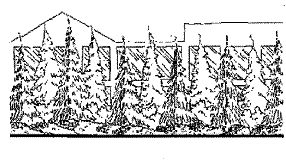
Type I – Screen |
|
Type I landscaping shall generally consist of a mix of predominately evergreen plantings, including living trees, shrubs, and ground covers. Evergreen trees shall be a minimum height of four feet at time of planting. Plantings shall be chosen and spaced so as to grow together within five years in a manner that is sufficient to obscure sight through the barrier. The entire planting strip shall be landscaped; however, those plantings used to achieve the sight-obscuring screen shall cover the length of the strip. Existing vegetation as defined in AHMC 17.22.080 may be incorporated into the landscape design as set forth in AHMC 17.22.050 and shall be considered acceptable in lieu of new plantings, if it contributes to achieving the intent of this chapter. |
|
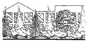
Type II – Visual Buffer |
|
Type II landscaping shall consist of a mix of evergreen and deciduous plantings including living trees, shrubs, and ground covers. Plantings of shrubs and ground covers shall be chosen and spaced to result in a total covering of the landscape strip. Shrubs shall be of a type that, within five years, provides a visual buffer. Deciduous trees shall have a minimum trunk diameter of one and three-quarter inches at time of planting. Existing vegetation as defined in AHMC 17.22.080 may be incorporated into the landscape design as set forth in AHMC 17.22.050 and shall be considered acceptable in lieu of new plantings, if it contributes to achieving the intent of this chapter. |
|
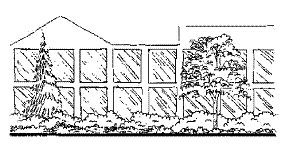
Type III – Open Area Landscaping |
|
Type III landscaping shall consist of canopy-type deciduous trees or spreading evergreen trees, planted in wells or strips, with a mix of living evergreen and deciduous ground covers and low shrubs. Plantings of shrubs and ground covers shall be chosen and spaced to result in a covering of the landscape strip within five years. Applicants are encouraged to use boulders, rocks and natural materials in the landscaping strip. Shrubs shall be of a type that does not exceed a height at maturity of approximately four feet. Planting wells or strips shall be a minimum of 32 square feet in area, with the narrowest dimension not less than four feet. Deciduous trees shall have a minimum trunk diameter of one inch at time of planting. Evergreen trees shall be a minimum of four feet tall at time of planting. Existing vegetation as defined in AHMC 17.22.080 may be incorporated into the landscape design as set forth in AHMC 17.22.050 and shall be considered acceptable in lieu of new plantings, if it contributes to achieving the intent of this chapter. |
|
Type IV – Native Plant Materials/Xeriscaping |
|
Type IV landscaping is not intended to be used as screening or buffering between zones in 17.22 Table 3. Type IV includes drought-tolerant trees or shrubs planted in strips with a mixture of rocks and grasses to meld with the surrounding landscape and discourage excessive water use. |
B. All trees, shrubs and plants and materials used shall be in accordance with the American Association of Nurserymen Standards (ANSI 2601-1973) or better.
C. Berms, when planted with turf grass, are not to exceed a slope of three horizontal units to one vertical unit. A slope of two horizontal units to one vertical unit is permissible when the berm is planted with shrubs and other ground cover. Slopes for planted areas are not to exceed two horizontal units to one vertical unit.
D. Slopes for storm water facilities planted with turf grass are not to exceed a slope of three horizontal units to one vertical unit. Storm water facilities shall not have more than 50 percent of the perimeter defined by a wall. Walls around storm water facilities shall not exceed 30 inches.
E. Shrubs shall be a minimum two-gallon root ball size at the time of planting.
F. Annual flowers are allowed substitutes for groundcovers for no more than 10 percent of the area required to be landscaped.
G. Overall design effect must be taken into consideration in respect to plant conflicts with utilities, lighting, fire hydrants, utility vaults, etc.
H. The total amount of traditional landscaping type is shown in the table below:
|
Landscaping Requirement |
Type I |
Type II |
Type III |
|---|---|---|---|
|
Deciduous trees |
Maximum 25% |
Maximum 50% |
Mix |
|
Evergreen shrubs |
Maximum 100% |
Maximum 75% |
Mix |
|
Total shrubs |
4 shrubs/ |
3 shrubs/ |
2 shrubs/ |
I. The total amount of native plant landscaping or xeriscaping required is shown in the table below:
|
Landscaping Requirement |
Type IV |
|---|---|
|
Vegetative groundcover and shrubs |
Maximum 75% |
|
Trees |
Optional |
|
Rocks, grass or rock columns |
Maximum 25% |
Plantings of shrubs and groundcovers shall be chosen and spaced to result in a total covering of the landscape strip. The landscape area may include grass, rocks or approved groundcover, provided the correct numbers of shrubs are installed.
J. Applicants are encouraged to follow the recommended tree and shrub list from the Airway Heights Public Works Standards Manual. (Ord. C-1086 § 1, 2025; Ord. C-675 § 273, 2008)
17.22.070 Location of required landscaping.
A. The following table indicates the type and width of landscaping required along side and rear property lines not abutting public streets for various proposed uses, depending on the zoning of adjacent parcels:
|
Adjacent Property Use |
Neighborhood Family Residential (NFR) |
Multifamily (MFR) |
Commercial (C-1, C-1A, C-2) |
Light Industrial (I-1) |
Heavy Industrial (I-2) |
|---|---|---|---|---|---|
|
Residential (NFR) |
|
Type III 10 feet wide |
Type II 10 feet wide |
Type II 15 feet wide |
Type I 15 feet wide |
|
Multifamily (MFR) |
Type II 10 feet wide |
|
Type III 10 feet wide |
Type II 10 feet wide |
Type I 15 feet wide |
|
Commercial (C-1, C-1A, C-2) |
Type II 10 feet wide |
Type III 10 feet wide |
|
Type III 10 feet wide |
Type II 15 feet wide |
|
Light Industrial (I-1) |
Type II 10 feet wide |
Type II 10 feet wide |
Type III 10 feet wide |
|
Type III 10 feet wide |
|
Heavy Industrial (I-2) |
Type I 10 feet wide |
Type I 10 feet wide |
Type II 10 feet wide |
Type II 10 feet wide |
|
A lower number type may be substituted for a higher number type.
The Technical Review Committee may require Type I landscaping when the potential exists for a nuisance.
Type IV landscaping is not intended to be used for buffering between zones.
Please note: The Technical Review Committee may alter the landscaping type required, depending upon the surrounding uses or if the land is considered a small lot.
B. The owners of adjacent properties may agree to consolidate their perimeter plantings along shared boundaries, with each property owner providing one-half of the required landscaping. (Ord. C-1086 § 1, 2025; Ord. C-675 § 274, 2008)
17.22.080 Existing vegetation retention.
A. Existing vegetation may be used to meet all or portions of the landscaping requirements of this chapter. Significant trees, which shall mean existing trees over eight inches in caliper as measured four feet above grade, shall be retained in developments as follows:
1. All significant trees located within any street landscaping areas and which are not dead, dying, diseased, and do not pose a safety hazard subject to City Planner approval shall be retained;
2. At least 10 percent by number of the significant trees on the subject property shall be retained;
3. The City may approve modifications or require minor site plan alterations to achieve maximum tree retention. (Ord. C-1086 § 1, 2025; Ord. C-675 § 275, 2008)
17.22.090 Use of native plants or xeriscaping.
A. The following guidelines are not intended to be mandatory but are suggested ideas for reducing the maintenance cost of a development, enhancing the long-term health of plant material, and reducing the cost of watering and conserving water resources.
B. The intent of a root control guideline is to reduce the potential of tree roots causing costly damage to adjacent asphalt and concrete surfaces.
1. Any tree planted within five feet of public or private road pavement edge, curbing, or sidewalk, or within required parking areas should install a root control barrier. Root control barriers should consist of galvanized metal or plastic sheets extending a minimum of two feet below the finished grade of the surrounding surface.
C. The intent of water conservation guidelines is to take the most advantage of natural watering and therefore reduce the amount of water required to maintain plant material health during the dry season. The intent of a plant material guideline is to encourage use of plants native to the Spokane region, to maximize use of rainwater, to reduce general maintenance needs, and to encourage the development of landscape designs reflective of the natural surroundings.
1. Soil Preparation.
a. Landscape areas should be deep-tilled to a depth of at least 12 inches to facilitate deep water penetration and soil oxygenation. Use of soil amendments is encouraged to improve water drainage, moisture penetration, soil oxygenation, and/or water holding capacity. Soil amendments are organic matter such as composted yard waste, sewer biosolids, and forestry byproducts, but do not include topsoil or any mix with soil as an element. (Sphagnum moss is not recommended because it provides only short-term value and is a nonrenewable resource.)
b. For all newly landscaped areas, including single-family residences, organic matter (three to four cubic yards of organic matter per 1,000 square feet of landscape area) should be incorporated to a depth of four to six inches.
c. For newly landscaped areas where topsoil is limited or nonexistent, or where soil drainage is impeded due to subsurface hardpan, six to 24 inches of sandy loam topsoil should be spread in all planting and turf areas, in addition to the incorporation of organic matter into the top horizon of the imported soil.
d. Soil analysis of new or renovated turf areas should include a determination of soil texture, including percentage of organic matter; an approximated soil infiltration rate; and a measure of pH value.
2. Mulching. Mulch should be applied regularly to, and maintained in all, planting areas to assist soils in retaining moisture, reducing weed growth, and minimizing erosion. Mulches include organic materials such as wood chips and shredded bark and inert organic materials such as decomposed lava rock, cobble, and gravel. The use of inert organic mulches is recommended in conjunction with geotextiles. Nonporous materials, such as plastic sheeting, are not recommended for use in any area of the landscape because of downslope erosion and potential soil contamination from herbicide washing. Mulches should be applied to the following depths: three inches over bare soil, and two inches where plant materials will cover.
3. Compatible Water Use Design. Trees and plants having similar climatic, water, soil, and maintenance requirements should be grouped in distinct and compatible planting areas as follows: (a) plants which, at maturity, require moist soils and supplemental water in addition to natural rainfall to survive; (b) plants which, at maturity, survive on natural rainfall with supplemental water during seasonal dry periods that are unusual due to their length, high temperature, or lack of moisture; and (c) plants which, at maturity, survive on natural rainfall without supplemental water. Grouping/zoning of plantings should coordinate with the irrigation hydrozoning plan as well as topographic features in the landscape so that plantings benefit from collected precipitation, runoff, or water harvesting.
D. It is also the intent of the plant material guideline to encourage the use of drought-tolerant plants in landscape designs to reduce the amount of water devoted to outdoor watering at a time when population pressures are increasing faster than the water supply.
1. Applicants are encouraged to maximize the use of native plant material to the extent possible. When native drought-tolerant plant materials are used exclusively, and the landscape architect can appropriately certify, the City Planner may waive the requirement for automatic irrigation of landscaped areas.
2. Applicants are encouraged to use boulders and rocks in landscaping to reduce the impact on the water supply.
3. Native plant materials may include:
|
Drought-Tolerant Shrubs |
|
|
|
Common Name |
Scientific Name |
Height |
|
Carabana |
Carabana arborescens |
15' |
|
Golden Currant |
Ribes aureum |
2' – 5' |
|
Serviceberry |
Amelanchier alnifolia |
6' – 10' |
|
Silver Buffaloberry |
Shepherdia argentea |
6' – 20' |
|
Snowberry |
Symphoricarpus albus |
3' |
|
|
|
|
|
Drought-Tolerant Trees |
|
|
|
Common Name |
Scientific Name |
Height |
|
Austrian Pine |
Pinus nigra |
35' – 45' |
|
Northern Red Oak |
Quercus borealis |
60' – 70' |
|
Jeffery Pine |
Pinus jefferyi |
50' – 80' |
|
Mugo Pine |
Pinus mugo |
5' – 20' |
|
Ponderosa Pine |
Pinus ponderosa |
120' – 140' |
|
|
|
|
|
Other Permitted Shrubs |
|
|
|
Common Name |
Scientific Name |
Height |
|
Black Hawthorn |
Crataegus douglasii |
20' – 30' |
|
Blue Elderberry |
Sambucus cerulea |
4' – 20' |
|
Chokecherry |
Prunus virginiana |
10' – 15' |
|
Mock Orange |
Philadelphus lewisii |
6' – 10' |
|
Tatarian Honeysuckle |
Lonicera tatarica |
4' – 10' |
|
Woods’ Rose |
Rosa woodsii |
2' – 5' |
|
|
|
|
|
Other Permitted Trees |
|
|
|
Common Name |
Scientific Name |
Height |
|
Amur Maple |
Acer ginnala |
15' – 20' |
|
Black Walnut |
Juglans nigra |
60' – 70' |
|
London Planetree |
Platanus acerifolia |
75' – 100' |
|
Sugar Maple |
Acer saccharum |
75' – 100' |
|
Douglas Fir |
Pseudotsuga menziesii |
100' – 130' |
|
Noble Fir |
Abies procera |
90' – 200' |
4. Other plant species may be permitted if approved by the City Planner or if they have been recommended by a certified landscape architect to fulfill the intent of this section.
E. Incorporation of xeriscaping principles is highly encouraged in an effort to conserve potable water. Some examples are:
1. The use of drip irrigation for shrubs and trees;
2. The adjustment of spray heads to minimize overspray onto walks, driveways, buildings, and other impervious surfaces;
3. Adjustment of system to operate at night. (Ord. C-1086 § 1, 2025; Ord. C-675 § 276, 2008)
17.22.100 Parking area landscaping.
A. The purpose of the landscaping provisions for parking areas is as follows:
1. To break up the visual effect created by large expanses of barren asphalt;
2. To encourage the preservation of mature trees;
3. To ensure the preservation of land values by creating an environmental quality that complements the objectives of the respective land uses.
B. Parking area landscaping requirements of this section shall apply only to those areas which are used for or designated as customer parking areas and shall not apply to those areas designated as sales or inventory areas.
C. Landscaping on Street Frontage. Unless otherwise stated, a parking area or outdoor display area fronting on a street right-of-way shall provide a landscaped planting area of Type III or IV landscaping of at least five feet in width along the entire street frontage except for driveways; if the plantings shall not obstruct the sight distance at street intersections or driveway approaches.
D. Additional Plantings. Additional plantings may be placed in street right-of-way behind the sidewalk line if the property owner provides the City Manager with a written release of liability for damages which may be incurred to the planting area from any public use of right-of-way.
E. Amount and Location. At least 10 percent of the parking area shall be devoted to landscaping (exclusive of landscaping required by subsection (C) of this section within the public right-of-way); if:
1. No landscaping area shall be less than 32 square feet in area;
2. No parking stall shall be located more than 60 feet from a landscaped area. The City Planner may approve landscaping plans involving alternatives to this specification for individual properties if it finds the alternative would be more effective in meeting the purposes of this section;
3. Landscaping should be located between parking stalls, at the end of parking columns, or between stalls and the property line. Landscaping which occurs solely between the parking lot and a building or recreation area shall not be considered as satisfaction of these requirements;
4. All required landscaping shall meet the clear-view triangle requirements pursuant to Chapter 17.19 AHMC. No street tree shall be planted closer than 10 feet to the hydrant per AHMC 12.34.060.
F. Size Exception. Parking lots containing less than 20 parking spaces need provide only Type III or Type IV landscaping to satisfy the 10 percent area requirement.
G. Materials Used. Planting areas shall include liberal landscaping using combinations of such materials as trees, ornamental shrubs, gravel, river rock, driftwood, rockeries, or lawn if the materials used are approved by the City Engineer in relationship to storm water disposal.
H. Internal Property Lines. When a parking area abuts residentially zoned property along any interior property line, a minimum six-foot-high screening device, or a minimum 15-foot-wide planting area with Type I or Type II landscaping, as determined by the City Planner, shall be installed along the property line.
I. Maintenance of Landscaped Area. All required landscaping shall have automatic sprinkler systems and be maintained in a healthy growing condition. Dead or dying plantings shall be removed and replaced, or repaired.
1. Per AHMC 12.34.090, no tree shall be topped.
J. Protective Curbing. Landscaped areas shall be protected from vehicle damage by protective curbing consistent with drainage requirements.
K. Timing of Installation. All required landscaping shall be installed prior to issuance of a certificate of occupancy with provision that the Planning Department or Building Official may authorize up to a four-month delay to initiate landscaping when planting season conflicts would produce high probability of plant loss. Bonding or other adequate security may be required of an applicant to ensure that the landscaping requirements herein are met. (Ord. C-1086 § 1, 2025; Ord. C-675 § 277, 2008)
17.22.110 Street landscaping.
A. The following landscaping is required adjacent to all streets except where permitted structures and driveways are proposed:
1. Within all developments to be located in the multiple-family (MFR) zone, a Type III landscaping strip with a minimum width of 10 feet shall be provided;
2. Within all developments to be located in any commercial (C-1, C1-A, or C-2) zone, a Type III or IV landscaping strip with a minimum width of five feet shall be provided with the use of deciduous trees preferred;
3. Within all developments to be located in an industrial (I-1 or I-2) zone, a Type III or Type IV strip with a minimum width of 15 feet shall be provided;
B. The plantings shall not violate the sight distance requirements at street intersections or driveways, nor interfere with the adequate flow of storm water runoff along drainage easements.
C. Street frontage requirements apply only to the portion of the parcel developed at the time of application. (Ord. C-1086 § 1, 2025; Ord. C-675 § 278, 2008)
17.22.120 Institutional and recreational use.
All public or institutional uses, including churches, commercial and noncommercial recreation facilities (e.g., country clubs, golf courses, tennis courts), community clubs, schools, charitable and fraternal organizations, hospitals, public utility facilities, sewage transfer plants, government facilities, museums, libraries, stations, retirement homes, nursing homes, and similar uses, shall provide landscaping as prescribed by AHMC 17.22.090(B) and 17.22.140, unless otherwise modified by AHMC 17.22.050. (Ord. C-1086 § 1, 2025; Ord. C-675 § 279, 2008)
17.22.130 Clear-view triangle.
All landscaping within the clear-view triangle shall meet the requirements of Chapter 17.19 AHMC. (Ord. C-1086 § 1, 2025; Ord. C-675 § 280, 2008)
17.22.140 Building facade landscaping.
Perimeter landscaping width requirements can be reduced by 25 percent, but not less than five feet, if the reduced area is reallocated to landscaping along the facade of a building adjacent to a street right-of-way. (Ord. C-1086 § 1, 2025; Ord. C-675 § 281, 2008)
17.22.150 Installation requirements.
Landscaping required pursuant to this section must be installed to the satisfaction of the Planning Department, in accordance with the approved site development plan, before building occupancy. The Planning Department or Building Official may authorize up to a four-month delay to initiate landscaping where planting season conflicts would produce a high probability of plant loss. In the interim, a temporary certificate of occupancy (per currently adopted International Residential Code) will be issued. When landscape installation is complete, the owner must contact the Building Department who will then inspect the property within 72 work week hours. If landscaping is not installed as planned, the applicant will receive formal notification and be fined according to the provisions of AHMC 17.22.170. After 30 days of formal noncompliance, the temporary certificate of occupancy will be rescinded by the Building Department. The Planning Department may require performance bonds or other appropriate security, including letters of credit, to ensure the landscaping will be installed according to the approved plan specifications. To phase landscaping, performance bonds are required and must be tied to a length of time, not completion of a building. (Ord. C-1086 § 1, 2025; Ord. C-675 § 282, 2008)
17.22.160 Maintenance requirements.
Property owners shall keep the required planting area maintained in a manner to serve the original purpose intended. Lack of maintenance shall constitute a violation of this code. All of the following maintenance procedures shall be practiced by the applicant:
A. Dead, diseased, stolen, or vandalized plantings shall be replaced within six weeks. If seasonal temperatures do not allow immediate replacement, plants shall be replaced at the beginning of their next planting season.
B. Planting area shall be maintained, pruned, trimmed and kept free of weeds and trash in order to maintain plant health and appearance.
C. Property owners shall keep the required planting area maintained with automatic sprinkler systems and in a manner to serve the original purpose intended. Lack of maintenance shall constitute a violation of this code. (Ord. C-1086 § 1, 2025; Ord. C-675 § 283, 2008)
17.22.170 Penalties.
When landscaping is not maintained, the City Planner or appointed designee is authorized to notify the owner, tenant, lessee, or assignee of any such owner that the landscaping is not being adequately maintained and of the penalty for failure to maintain. The notice shall specify the date by which maintenance must be accomplished, and shall be sent by certified mail to the owner at his/her last known address. Compliance must be attained within 30 days of the date of notice, unless seasonal temperatures do not permit replanting. In these cases, compliance must be attained 30 days after seasonal temperatures permit replanting. If the landscaping has not been brought into accord by the date of compliance, each day thereafter shall be considered a separate violation, and the property owner shall be fined an amount specified by the most recent City resolution, based per day, until compliance is achieved. The accrual of civil penalties is suspended pending a decision on any appeal (from the date of filing to the date of the final decision). (Ord. C-1086 § 1, 2025; Ord. C-675 § 284, 2008)
17.22.180 Appeals.
Applicants may appeal an administrative interpretation and/or decision in accordance with AHMC 14.01.200. (Ord. C-1086 § 1, 2025; Ord. C-1055 § 2, 2024; Ord. C-675 § 285, 2008)
17.22.190 Governing regulation.
If there are two conflicting regulations within the AHMC, the stricter of the two shall apply. (Ord. C-1086 § 1, 2025; Ord. C-675 § 286, 2008)