


Chapter 17.12
SUBDIVISION STANDARDS
Sections:
17.12.020 Subdivision design guidelines.
17.12.030 Four-step design process.
17.12.040 Administrative departures.
17.12.050 Natural area and community space.
17.12.070 General residential subdivision standards.
17.12.080 Multifamily and nonresidential subdivisions.
17.12.090 Special requirements for critical areas and shoreline.
17.12.010 Applicability.
This chapter sets forth standards for short subdivisions, long subdivisions, large lot subdivisions, and nonresidential and multifamily subdivisions. Specific requirements relevant to each individual type of subdivision are provided throughout various chapters of this title. (Ord. 2019-03 § 5 (Exh. A), 2019)
17.12.020 Subdivision design guidelines.
Subdivision development in all zoning districts shall comply with the requirements of the Bainbridge Island design review regulations – “Design for Bainbridge,” as amended, as follows:
A. Detached single-family residential subdivision development shall comply with Chapters 1, 2, 3 and 5, as applicable, and Chapter 6;
B. Attached single-family residential and multifamily residential development shall comply with Chapters 1, 2, 3, 4 and 5, as applicable;
C. Commercial subdivision development shall comply with all chapters, as applicable. (Ord. 2019-03 § 5 (Exh. A), 2019)
17.12.030 Four-step design process.
The city’s approach to planning for subdivisions requires a four-step process that gives the highest priority to identification and conservation of existing natural site features. This process reverses the conventional site planning approach, which typically begins by laying out the streets, lot lines and building footprints. Instead of first identifying the areas to be cleared for development, the design process begins by analyzing on-site resources and the site’s relationship to surrounding properties, in order to identify what resources are most worthy of preservation and what areas can best accommodate development.
This design process is required for all residential subdivisions. The process is further defined in BIMC 2.16.125.D; it consists of four steps: (A) delineate natural area; (B) locate homesites and community space; (C) define access; and (D) draw lot lines. (Ord. 2019-03 § 5 (Exh. A), 2019)
17.12.040 Administrative departures.
A. A departure from existing subdivision standards may be requested only by an applicant to allow use of an alternative standard not listed among the applicable requirements of BIMC 17.12.050 through 17.12.070. Departures are not variances and are not required to meet the criteria associated with a variance application. Rather, departures allow adjustment of existing standards to achieve better outcomes in cases where strict application of the existing standard would result in an inferior subdivision design.
B. Departures from the subdivision standards in BIMC 17.12.050 through 17.12.070 may be permitted as part of the subdivision review process. In order for such a departure to be allowed, it must satisfy the intent of the four-step design process, and the resulting subdivision must be consistent with the general purpose and intent of the subdivision ordinance and the specific standard(s). A departure shall not be allowed from the following standards:
1. Natural area;
2. Community space;
3. Homesite size.
C. Any request for one or more departures shall be made at the design guidance review meeting as part of the preapplication phase of the project. Departures shall be reviewed concurrently with a preliminary application for subdivision. The design review board may include an administrative departure in its recommendation to the planning commission, if all of the following criteria are met:
1. Because of unusual shape, exceptional topographic conditions, environmental constraints or other extraordinary situation or condition in connection with a specific piece of property, strict adherence to the existing standard would result in practical difficulties or unnecessary hardships inconsistent with the general purpose and intent of the subdivision ordinance as provided in BIMC 17.04.010;
2. The granting of the departure results in a subdivision with greater natural resource conservation value, less adverse impact to adjoining properties, or more practical design because of topography, critical area, or other extenuating circumstance; and
3. All possible efforts to comply with the standard or minimize potential harm or adverse impacts have been undertaken. Economic consideration may be taken into account but shall not be the overriding factor in approval; and
4. The departure is consistent with other applicable regulations and standards; and
5. The granting of any departure will not be unduly detrimental to the public welfare nor injurious to the property or improvements in the vicinity in which the property is located.
D. If the design review board’s recommendation is to grant the departure(s), the departure shall be included as a component of the project in subsequent reviews pursuant to BIMC 2.16.110.D.1 and 2.16.110.E. The departure(s) shall be included in the director’s recommendation to the hearing examiner unless a deviation from the recommendation is documented in the director’s report pursuant to BIMC 2.16.110.E.3.b.
E. For short subdivisions not requiring design review board review, request for departures shall be made at the preapplication conference. The director may approve one or more departures, if the criteria in subsection C of this section are met, as part of their administrative decision for the preliminary subdivision in accordance with BIMC 2.16.070.F. (Ord. 2019-03 § 5 (Exh. A), 2019)
17.12.050 Natural area and community space.
A. Natural Area Required. All residential subdivisions shall provide natural area consistent with Chapter 17.28 BIMC, Definitions, Table 17.12.070-1, and the following standards:
1. Natural Area Objectives. The natural area(s) shall support one or more of the following objectives:
a. Preservation and protection of:
i. Natural resources and ecological functions, including groundwater recharge;
ii. Native soils and topography;
iii. Historic island landscapes including farmland, meadows, pastures, and orchards; and
iv. Scenic views along roads.
b. Promoting interconnected open space, wildlife corridors, and undeveloped areas;
c. Promoting a development pattern consistent with island character.
2. Types of Natural Area. The natural area(s) shall be designated as the first step in the four-step design process defined in BIMC 2.16.125.D. Natural areas consist of primary and secondary natural areas.
a. Primary Natural Areas (PNA). PNAs form the core of the natural area to be protected. PNAs include the following:
i. Critical areas other than critical aquifer recharge areas;
ii. Critical area buffers and setbacks; and
iii. Shoreline buffers.
b. Secondary Natural Areas (SNA). SNAs are noteworthy or significant features of the natural landscape. SNAs include the following:
i. Farmland, pastures, meadows, and orchards;
ii. Mature trees and shrubs;
iii. Wildlife corridors;
iv. Greenways and trails;
v. Scenic viewsheds;
vi. Mature vegetation on ridgelines;
vii. Freestanding landmark trees, as defined in Chapter 16.32 BIMC, and their critical root zone (as identified by a consulting arborist).
3. Amount of Natural Area Required. The natural area requirement shown in Table 17.12.070-1 shall be provided as shown in Figure 17.12.070-1, Natural Area Allocation, and in accordance with the following standards:
a. The area provided for natural area shall be based on and consistent with the existing types of natural areas (listed in subsection A.2 of this section) on the subject property, up to the maximum shown in Table 17.12.070-1, unless additional natural area is required due to the presence of PNAs (listed in subsection A.2.a of this section).
b. All PNAs (listed in subsection A.2.a of this section) are required to be designated as natural area even if this amount exceeds the maximum percent required shown in Table 17.12.070-1. This may result in no subdivision being permitted or a subdivision with less than the maximum number of lots allowed in accordance with Table 17.12.070-1.
c. If the area being subdivided contains less than the percentage of natural area shown in Table 17.12.070-1, then the designated natural area is identified accordingly and community space is required pursuant to subsection B of this section.
d. All lands subject to critical area regulations by Chapter 16.20 BIMC shall remain subject to those regulations. Buffer modifications or setback reductions may be pursued.
e. Natural areas may be included on individual lots.
f. Natural areas shall not be required to be dedicated to the public, and the owner shall not be required to permit public access to designated natural areas.
g. All natural areas shall be depicted on the face of the preliminary and final plat.
Figure 17.12.050-1 Natural Area Allocation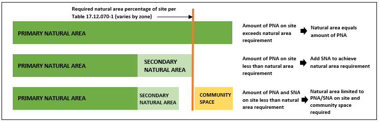
4. Aquifer Recharge Protection Area (ARPA). Subdivisions in the R-0.4, R-1, and R-2 zoning districts shall meet the requirements of BIMC 16.20.100 and the following standards:
a. If a proposed subdivision includes more than one parcel, the ARPA shall be calculated based on the total square footage of all parcels;
b. If the required ARPA is greater than the required natural area, the natural area shall be increased to achieve the required ARPA area;
c. The 12,500-square-foot development area allowed pursuant to BIMC 16.20.100.E.2.b shall be allocated in aggregate; that is, the total development area within the subdivision shall be determined by the total number of lots allowed multiplied by 12,500;
d. ARPAs within subdivisions shall be consistent with the ARPA development standards listed in BIMC 16.20.100.D.
5. Natural Area Configuration. Designated natural areas shall be configured in a manner that enhances and promotes the natural resource characteristics of the property and development pattern of the surrounding area. Natural area configuration shall satisfy the following guidelines to the extent feasible:
a. Natural area should be concentrated in large, consolidated areas; and
b. Natural area should connect to adjacent off-site open space areas, designated wildlife corridors and trails, and/or critical areas, where feasible; and
c. Natural area should be designed to preserve views from off site of the subject property; and
d. Natural area should be delineated with a low perimeter-to-area ratio;
e. Natural area shall have a minimum width of 50 feet outside of roadside and perimeter buffers; and
f. Natural area may be included as a portion of one or more lots or may be contained in a separate tract, except for critical areas and their buffers and setbacks.
6. Natural Area Fencing and Signage. Fences and/or signs delineating the boundary of natural areas are required. The director shall determine which option (fence or sign) is required, based on the recommendations from the design guidance review meeting.
a. If fencing is required:
i. Low-impact fences are preferred and must be constructed in accordance with the definition in BIMC 17.28.020;
ii. Fencing is not required at the exterior boundary of the subdivision;
iii. Gaps in fencing not exceeding five feet are permitted; and
iv. Gates are permitted if they are consistent with the definition of low-impact fences in BIMC 17.28.020.
b. If signs are required:
i. They shall be constructed in accordance with the definition in BIMC 17.28.020; and
ii. Typically, they shall be spaced at intervals of 50 feet, allowing for variation due to reasons such as topography, configuration of natural area, distance from other features, etc.
c. If signage is required and encroachments into the designated natural area occur, the director may require that the owner install fencing and/or additional signage to prevent future encroachments. Required fencing and signs shall be maintained in good repair, with repair or replacement to occur within 60 days.
7. Natural Area Ownership. Ownership of natural area shall be established consistent with one of the following forms of ownership:
a. Private Ownership. Natural areas may be held in private ownership if established by easements, restrictive covenants, the natural area management plan, or similar legal means; or
b. Common Ownership. Natural areas may be held in common by a home or property owners’ association or other similar organization. For the purposes of this title, if a land trust or a similar conservancy maintains ownership or a conservation easement, that shall be considered common ownership. If this ownership pattern is selected, covenant, conditions, and/or restrictions shall be required; or
c. Public Ownership. Designated natural areas shall not be required to be dedicated to the city or other public agency, and the owner shall not be required to permit public access to designated natural areas. However, if the owner offers to dedicate, the city or other public agency may choose to accept ownership of natural areas. Consequently, upon approval and acceptance by the city council, the natural areas shall be dedicated to the public.
8. Natural Area Maintenance. An applicant shall submit a draft natural area management plan (NAMP), as described in the Bainbridge Island administrative manual, for review as part of the preliminary plat application. Final approval of the NAMP will occur at the time of final plat approval. The natural area management plan shall include:
a. A list of all approved uses for the natural areas. Where uses in separate natural areas vary, the specific location of each use shall be depicted graphically.
b. A maintenance plan for natural areas that clearly describes the frequency and scope of maintenance activities for natural areas.
c. The approved NAMP must be filed with the Kitsap County auditor. In the event that the natural area is not maintained consistent with the NAMP, the city shall have the right to enter the property for necessary maintenance, with the cost of such maintenance assessed against the landowner or, in the case of a homeowners’ association, the owners of the properties within the subdivision, and shall, if unpaid, become a tax lien on such property or properties.
9. Allowed Uses in Natural Area. The following uses are allowed in those natural areas that are not part of a required roadside or perimeter buffer (unless zoning regulations of BIMC Title 18, provisions of the shoreline master program per Chapter 16.12 BIMC, or critical areas regulations of Chapter 16.20 BIMC, including allowed uses within aquifer recharge protection areas, restrict that use):
a. Passive recreation, including pervious trails;
b. Agricultural uses and fencing necessary for animal control in SNAs only;
c. Potable water wells and well houses;
d. Low-impact fencing or signs marking the natural area boundary or critical area boundary;
e. On-site sewage treatment system use approved by the director for all residential zones, if the applicant can demonstrate that (i) the proposed use will not adversely affect the function or characteristics of the specific natural area, (ii) the system is approved by the Kitsap County health district, and (iii) construction of the system will not require the removal of significant trees, native forests, vegetation within a required buffer for designated critical areas subject to Chapter 16.20 BIMC, or vegetation within areas designated for protection under the shoreline master program pursuant to Chapter 16.12 BIMC;
f. Storm drainage system use approved by the director for all residential zones if the applicant can demonstrate that (i) enhanced vegetation will be provided so that the facility appears as a natural feature, (ii) the proposed use will not adversely affect the function or characteristics of the specific natural area, (iii) the system meets the design standards of Chapters 15.20 and 15.21 BIMC, including low-impact development designs, and (iv) the system design must contribute to the function and characteristics of the natural area feature by providing the following:
i. No above-ground storm detention facilities are permitted; and
ii. Enhanced vegetation will be provided in conjunction with the storm drainage facility in order to make it a more natural feature; and
iii. Pedestrian trails should be considered as part of the design; and
iv. While fencing of designated natural areas or critical areas may be required by the director pursuant to subsection A.8.a of this section, separate fencing of storm drainage facilities or areas shall only be installed if necessary to protect public safety. Where fencing is required, low-impact fencing shall be used, and chain-link fences are prohibited unless superseded by state law.
g. Playgrounds and tot lots, picnic shelters and benches, community gardens, bus shelters, community art, or fountains may be allowed within a designated natural area, provided the proposed use will not adversely affect the function or characteristics of the specific natural area.
h. Solar panels, small wind energy generators, composting bins, rainwater harvesting barrels, cisterns, and rain gardens/swales, as defined in Chapter 18.36 BIMC, may be allowed within a designated natural area, provided the proposed feature will not result in the damage or removal of significant trees.
B. Community Space Required. All residential subdivisions, except short subdivisions and as modified in subsection B.2 of this section, shall provide community space consistent with Chapter 17.28 BIMC, Definitions, Table 17.12.070-1, and the following standards:
1. Community Space Objectives. Community space shall accomplish one or more of the following objectives:
a. Provide a place for residents to gather in shared space.
b. Provide common buildings, open space, or gardens.
c. Provide space for unstructured recreation.
d. Enhance a felt and actual sense of security, identity, and community.
e. Provide a protected, traffic-free environment.
2. Amount of Community Space Required. The minimum community space shown in Table 17.12.070-1 shall be provided and shall be depicted on the face of the plat. Community space is not required in the R-0.4, R-1, and R-2 zoning districts if the maximum natural area is provided.
3. Community Space Configuration. Community space should adjoin the largest practicable number of lots within the development. Nonadjoining lots shall be provided with safe and convenient pedestrian access to community space. Community space shall not include perimeter or roadside buffers.
4. Community Space Ownership. Ownership of community space shall be established consistent with one of the forms of ownership set forth in subsection A.7 of this section.
5. Community Space Maintenance. An applicant shall submit a draft community space management plan (CSMP), as described in the Bainbridge Island administrative manual, for review as part of the preliminary plat application. Final approval of the CSMP will occur at the time of final plat approval. The community space management plan shall include:
a. A list of all approved uses for the community space. Where uses in separate community spaces vary, the specific location of each use shall be depicted graphically.
b. A maintenance plan for community space that clearly describes the frequency and scope of maintenance activities, and that meets all requirements set forth in this subsection B.5 and the Bainbridge Island administrative manual.
c. The approved CSMP must be filed with the Kitsap County auditor within 30 days of final plat approval. In the event that the community space is not maintained consistent with the CSMP, the city shall have the right to enter the property for necessary maintenance, with the cost of such maintenance assessed against the landowner or, in the case of a homeowners’ association, the owners of the properties within the subdivision, and shall, if unpaid, become a tax lien on such property or properties.
6. Allowed Uses in Community Space. Community space may include uses such as crop and animal agriculture, meadows, orchards, pastures, turf fields, and common buildings. Prohibited and allowed uses within community space shall be included in the draft terms, conditions, covenants, and agreements proposed for the subdivision, which shall be submitted with the preliminary subdivision application. Final terms, conditions, covenants, and agreements must be filed with the Kitsap County auditor within 30 days of final plat approval. (Ord. 2019-03 § 5 (Exh. A), 2019)
17.12.060 Homesites.
All single-family residential subdivisions require homesites located and designed consistent with Chapter 17.28 BIMC, Definitions, Table 17.12.070-1, and the following standards:
A. Homesite Area.
1. A homesite area no greater than the maximum area shown in Table 17.12.070-1 shall be provided for each lot and shall be depicted on the face of the plat.
2. The homesite area shall include the primary residential dwelling, accessory buildings, and on-site parking, if provided on each lot within the subdivision.
3. Other allowed uses and structures include residential landscaping, pathways, turf, and fences; individual water, stormwater, and septic infrastructure.
4. Homesites shall not contain any portion of required PNAs. Homesites may include critical aquifer recharge areas but no portion of an aquifer recharge protection area.
B. Homesite Siting. The four-step design process outlined in BIMC 17.12.030 is intended to allow the characteristics of the land to determine the most suitable location of homesites. Homesites shall be sited to meet the following standards:
1. Homesite locations shall be configured to maintain the natural features of the site and minimize topographic alteration and clearing of existing vegetation.
2. Homesite locations shall facilitate the efficient use of land by limiting areas of disturbance, impervious surfaces, utility extensions, and roadways.
3. If clustered pursuant to Table 17.12.060-1, homesites shall be located to minimize adverse impacts to adjacent, previously existing residential development and are not required to be located near any existing home on the property.
C. Homesite Clustering. Clustering, or grouping, of homesites is required in accordance with Table 17.12.060-1. (Ord. 2019-03 § 5 (Exh. A), 2019)
17.12.070 General residential subdivision standards.
All residential subdivisions shall comply with the following standards:
A. Constrained Lots. If, due to site or design constraints, more than one homesite with supporting infrastructure cannot be located on or provided for a subject property, no division of land is permitted. Constrained lots may also result in a subdivision with less than the maximum number of lots allowed in accordance with Table 17.12.070-1.
B. Preexisting Lots. Lots that have previously received final approval from the city, or that have previously received final approval from Kitsap County prior to inclusion within the city boundaries, and that do not comply with standards of this chapter shall be considered existing nonconforming lots, but any future resubdivision of any such lots shall comply with the requirements of this title.
C. Platted Lots. The platted lot defines the extent of private ownership of land within the subdivision. The size, shape and potential uses of a lot depend on many factors that will be considered in the subdivision design process. Establishing lot lines is the last step in the design process, but a desired result will affect decisions throughout the process, and the physical characteristics of the entire property will present both constraints and opportunities. Standards applicable to lots are found in this section and Table 17.12.070-1.
D. The short subdivision process shall not be used, either by a person alone or by persons acting together, at one time or over a period of time, to circumvent compliance with the more stringent requirements that control the subdivision of land into five or more lots. When an application for a short subdivision is filed within five years after the approval of a short subdivision on a contiguous land parcel, presumption of an attempt to circumvent short subdivision requirements may be invoked by the director as a basis for further investigation, to assure compliance with the intent of this provision and the requirements of a long subdivision.
E. Remaining Area. Any area not designated as public or private access, buffers, lots, or utility tracts shall be designated as either natural area or community space, in accordance with the objectives in either BIMC 17.12.050.A.1 or 17.12.050.B.1.
F. Site Disturbance. The extent of land disturbing activities, as defined in BIMC 15.20.020.22, shall be limited to the minimum required for site preparation and construction.
G. Compatibility with Adjacent Development.
1. Subdivisions shall be designed and located to ensure compatibility with existing adjacent development.
2. Views of house lots from exterior roads and abutting properties shall be minimized by preserving the natural topography and existing vegetation to the greatest extent possible.
H. Dimensional Standards.
1. Table 17.12.070-1 sets forth minimum and maximum dimensional standards for single-family residential development. Dimensional standards for multifamily and commercial subdivisions shall be in accordance with Tables 18.12.020-2 and 18.12.020-3.
2. Where a property is located in more than one zone district, units permitted by density calculations within each zone district must be constructed on the portion of the property located within that district and required setbacks for each zone district must be met. Permitted densities are not “blended” across the zone district line.
I. Septic Systems. Locations of individual or community drainfields and associated reserve drainfields shall comply with all applicable standards established by the Kitsap Public Health District or Washington Department of Health. Reserve drainfield areas shall remain undisturbed until such time as their use is required. This standard shall be noted on the face of the preliminary and final plat.
J. Streets and Vehicle Access. Subdivisions shall comply with the following standards unless modified by the city engineer:
1. Subdivisions shall comply with all applicable standards of the “City of Bainbridge Island Design and Construction Standards and Specifications,” as amended, and Island-Wide Transportation Plan, as amended. Deviations from the “City of Bainbridge Island Design and Construction Standards and Specifications” may be granted by the city engineer upon evidence that such deviations are in the public interest and that they are based on sound engineering principles and practices. All requirements for safety, function, appearance and maintainability must be fully met. Desired deviations must be requested at the design guidance review meeting during the preapplication phase of the project.
2. Each lot in a residential subdivision shall have direct access to a public or private street, except for those with shared driveways or alternative lot designs that provide shared or clustered parking outside of individual lots.
3. The street system of a proposed subdivision shall be designed to connect with any existing, proposed, or planned streets outside of the subdivision or to create a connection beneficial to the overall circulation of the surrounding area, as determined by the city engineer.
4. Interior street layout shall be oriented on the east/west axis, if feasible, to maximize active and passive solar access.
5. To minimize impervious surfaces, all public rights-of-way, access easements, private streets, and driveways shall not be greater than the minimum dimensions required to meet standards.
6. Street names and traffic regulatory signs shall be provided, and their locations shall be indicated on the plat/plan. The locations of mailboxes and traffic regulatory signs are only required on the plat/plan when other public improvements are required.
7. Transit stops shall be provided as recommended by Kitsap Transit.
K. Parking and Garages.
1. Parking shall be provided consistent with BIMC 18.15.020, except as modified by this subsection.
2. Parking spaces provided on individual lots must be located within the designated homesite.
3. Parking spaces may be located outside of individual lots, consolidated in a remote or satellite parking area, or in individual or shared garages.
4. Consolidated parking areas shall be landscaped in accordance with BIMC 18.15.010.F.
5. Shared garages are limited to five vehicle spaces and shall not exceed 60 feet in length or 1,440 square feet total.
6. Garages, including detached garages, located on individual homesites facing a public street shall be:
a. Limited to two vehicles; and
b. Either accessed from the side or rear or set back from the most front-facing exterior wall of habitable space a minimum of five feet unless the house is not visible from the public street.
L. Circulation and Access.
1. All subdivisions shall include a circulation and access system of walkways, paths, or trails that interconnect lots, commonly owned natural area, community space, and adjacent access facilities. Trails that provide connection to streets, public areas or other trails through the subdivision boundaries shall provide public access.
2. Multimodal facilities shall be consistent with the applicable standards of the “City of Bainbridge Island Design and Construction Standards and Specifications.”
3. Subdivisions may be required to provide dedicated access easements if one or more “trail connection zones” are located on the site as shown on Maps C and D (nonmotorized system plan) of the Island-Wide Transportation Plan, as amended.
4. Pursuant to RCW 58.17.110(1), sidewalks or other planning features shall be provided to assure safe walking conditions for students who walk to and from school.
M. Fencing.
1. Sight-obscuring fencing is prohibited at the exterior boundary of a subdivision.
2. Fencing within perimeter or roadside buffers or at the exterior boundary of a subdivision shall meet the requirements of low-impact fencing in accordance with the definition in BIMC 17.28.020.
3. Fencing around surface stormwater ponds shall not exceed three feet, six inches in height unless required by the city engineer for safety reasons.
4. Fencing is prohibited in those roadside areas maintained by the city (e.g., shoulders, ditches, utilities).
N. Landscaping. Individual homeowners are responsible for the maintenance and modification of landscaping on their lots, subject to any rules and guidelines established by a homeowners’ association or similar body. Native vegetation on the site should be retained and maintained where possible and landscaping should be responsive to the natural contours of the lot.
O. Perimeter Buffers. The intent of perimeter buffers is to visually and physically separate adjacent land uses and, when necessary, to minimize impacts of new development on adjacent properties. Perimeter buffers are not required along public rights-of-way.
1. Perimeter buffers shall be established at the exterior boundary of all subdivisions with a gross area of one acre or greater. Perimeter buffers shall be maintained as a “no cut/no build zone.” Existing native vegetation, including significant trees and tree stands, shall be preserved within perimeter buffers. The tree retention, protection, and replacement requirements of BIMC 18.15.010.C apply to perimeter buffers unless modified by this section.
2. The minimum width of perimeter buffers for single-family subdivisions shall be the width of the minimum homesite boundary to exterior plat boundary required in accordance with Table 17.12.070-1 or as determined by an administrative departure.
3. The minimum width of perimeter buffers for multifamily and commercial subdivisions shall be 25 feet in the R-0.4, R-1, and R-2 zoning districts and 15 feet in all other zoning districts either maintained or planted to achieve the full screen landscape standard provided in BIMC 18.15.010.D.4.a.
4. No additional planting is required in perimeter buffers of single-family subdivisions unless all of the following are met:
a. The width of the homesite boundary to exterior plat boundary is less than the minimum required in accordance with Table 17.12.070-1, as determined by an administrative departure; and
b. Existing vegetation does not provide an effective visual screen; and
c. In the R-0.4, R-1, and R-2 zoning districts, the abutting property is not capable of being subdivided.
5. If additional planting is required, the following standards shall apply:
a. In the R-0.4, R-1, and R-2 zoning districts, additional plant material shall be installed to achieve the full screen landscape standard provided in BIMC 18.15.010.D.4.a along the portion of the exterior plat boundary that has been reduced. Alternatively, the applicant may submit a landscape plan that results in an effective visual screen of the subdivision from off-site properties along the portion of the exterior plat boundary that has been reduced. In either case, any additional plant material shall be native species and no turf or lawn is permitted.
b. In all other zoning districts, additional plant material shall be installed to achieve the full screen landscape standard provided in BIMC 18.15.010.D.4.a along the portion of the exterior plat boundary that has been reduced.
6. No structures, buildings, or parking facilities may be located within perimeter buffers, except that utility lines and trails may be located within perimeter buffers, provided no significant trees are removed.
7. Perimeter buffers may be included as a portion of one or more lots or may be contained in a separate tract.
8. Perimeter buffers may be included as a portion of the natural area required in BIMC 17.12.050.A.
9. The performance and maintenance assurance requirements of BIMC 18.15.010.H apply to perimeter buffers if additional planting is required.
10. The irrigation and maintenance standards of BIMC 18.15.010 apply to perimeter buffers if additional planting is required.
11. Perimeter buffers shall be shown on the face of the preliminary and final plat.
P. Roadside Buffers. The intent of roadside buffers is to enhance or retain Island character through the minimization of disturbance of existing roadside vegetation and to screen new development from more highly traveled roads.
1. Roadside buffers are required for all subdivisions along collector or arterial roads in the R-0.4, R-1, and R-2 zoning designations. The minimum width of roadside buffers is 40 feet.
2. Roadside buffers shall be shown on the face of the preliminary plat. Roadside buffers may be part of individual lots or contained in a separate tract.
3. No structures, buildings, or parking facilities may be located within roadside buffers, except that utility lines and boxes, mailboxes, entry signs, bus shelters, and transit stops may be located within roadside buffers. Local access streets and trails may cross roadside buffers, provided no significant trees are removed.
4. Existing native vegetation, including significant trees and tree stands, shall be retained within roadside buffers. Tree retention, protection, and replacement requirements in BIMC 18.15.010.C apply to roadside buffers.
5. If existing vegetation provides an effective visual screen, or is consistent with existing roadside character, no additional planting is required. If existing vegetation does not provide an effective year-round visual screen, additional plant material shall be installed, consistent with the following:
a. Additional plant material shall be installed to achieve the full screen landscape standard provided in BIMC 18.15.010.D.4.a. Any additional plant material shall be native species and no turf or lawn is permitted;
b. Additional plant material is not required if mature forest or other dense vegetation is not part of the existing roadside character.
6. Roadside buffers may be included as a portion of the natural area or community space required in BIMC 17.12.050.
7. The performance and maintenance assurance requirements of BIMC 18.15.010.H apply to perimeter buffers.
8. The irrigation and maintenance standards of BIMC 18.15.010 apply to perimeter buffers.
9. For subdivisions designating community space that is intended for agricultural use and would be adversely impacted by the addition of screening landscaping, a roadside buffer shall be required to use screening landscaping that does not adversely impact the proposed agricultural use.
10. To accommodate an existing house that is located within 25 feet of the subdivision boundary adjacent to a collector or arterial road, the roadside buffer width shall be reduced to the width adjoining the existing home between the existing house and the subdivision boundary adjacent to the collector or arterial road.
Q. Design Diversity. All single-family residential subdivisions outside the Neighborhood Center, Mixed Use Town Center, High School Road, R-8, and R-14 zoning districts shall avoid a uniform appearance and repetitive building types by incorporating measures that promote design diversity, including:
1. The same model and elevation shall not be built next to each other. Different models are defined as having variations in floor plans.
2. Home designs shall be varied to achieve a minimum of one floor plan for each three homes. Mirrored floor plans to not count as different floor plans. Methods to provide variation include building modulation and secondary building forms (e.g., covered porches, dormers, window bays). The number of floor plans per home is as follows:
a. 1–3 homes: one plan;
b. 4–8 homes: two plans;
c. 9–11 homes: three plans;
d. 12 or more homes: four plans.
3. In long subdivisions, at least 20 percent of the homes must be at least 25 percent smaller than average home size and 20 percent may be up to 25 percent larger than average home size. If 20 percent of the homes is a fraction, round to the nearest whole number.
R. No City Maintenance of Streets in Short Subdivisions. Streets within a short subdivision shall not be maintained by the city unless such streets have been dedicated as a right-of-way, improved to current city standards, and accepted as part of the approved short subdivision. Therefore, unless accepted, the responsibility for maintenance shall lie with the owners of the lots. (Ord. 2019-03 § 5 (Exh. A), 2019)
17.12.080 Multifamily and nonresidential subdivisions.
Subdivisions established for multifamily and nonresidential uses shall comply with all provisions of BIMC Title 18 (Zoning) applicable to the zone district where the property is located, and for the type of development anticipated. This requirement shall include, without limitation, compliance with design guidelines and standards for lot areas, dimensions, mobility and access, landscaping, screening, and vegetative buffers. (Ord. 2019-03 § 5 (Exh. A), 2019)
17.12.090 Special requirements for critical areas and shoreline.
A. Critical Areas. Any portion of any subdivision that contains a critical area as defined in Chapter 16.20 BIMC must conform to all requirements of that chapter.
B. Shoreline. Any portion of any subdivision located within the jurisdiction of the shoreline master program, as defined in Chapter 16.12 BIMC, must conform to all requirements of that chapter. (Ord. 2019-03 § 5 (Exh. A), 2019)
Table 17.12.060-1: Homesite Clustering Requirements
|
ZONING DISTRICT DIMENSIONAL STANDARD |
R-0.4 |
R-1 |
R-2 |
R-2.9 |
R-3.5 |
R-4.3 |
R-5 |
R-6 |
R-8 |
R-14 |
NC |
MUTC HS I and II |
|---|---|---|---|---|---|---|---|---|---|---|---|---|
|
HOMESITE CLUSTERING REQUIREMENT |
||||||||||||
|
Short Subdivisions
2–4 lots with greater than 50% natural area and community space combined |
n/a [1] |
25 ft. maximum homesite separation |
||||||||||
|
2–4 lots with less than 50% natural area and community space combined |
No maximum homesite separation [1] |
|||||||||||
|
Site disturbance limited to 35% of site |
n/a [1] |
|||||||||||
|
Long Subdivisions
5–9 lots with maximum natural area requirement |
No maximum homesite separation [1] Site disturbance limited to 35% of site |
25 ft. maximum homesite separation |
||||||||||
|
5–9 lots with less than maximum natural area requirement |
50 ft. [2] |
25 ft.[2] |
||||||||||
|
Maximum homesite separation |
||||||||||||
|
10+ lots |
50 ft. |
25 ft. |
||||||||||
|
Maximum homesite separation |
||||||||||||
|
1. Homesite location needs to meet general requirements (BIMC 17.12.060.B). 2. As an alternative to maximum homesite separation, limit site disturbance to 35 percent of site. 3. Site disturbance includes land disturbing activity as defined in BIMC 15.20.020.22. |
||||||||||||
(Ord. 2019-03 § 5 (Exh. A), 2019)
|
ZONING DISTRICT DIMENSIONAL STANDARD |
R-0.4 |
R-1 |
R-2 |
R-2.9 |
R-3.5 |
R-4.3 |
R-5 |
R-6 |
R-8 |
R-14 |
NC |
MUTC HS I and II |
|---|---|---|---|---|---|---|---|---|---|---|---|---|
|
MINIMUM LOT AREA |
||||||||||||
|
Short and Long Subdivision |
If the site is not served by a public sewer system, the minimum individual lot area shall be determined by the Kitsap Public Health District in accordance with Section 15 of the Kitsap County Board of Health Ordinance 2008A-01, amended June 7, 2011, Onsite Sewage System and General Sewage Sanitation Regulations, as amended.
If the site is served by a public sewer system, there is no minimum lot area.
Individual lots may contain portions of natural area, community space, and access easements. |
|||||||||||
|
Large Lot Subdivision |
5 ac or 1/128th of a section, which-ever is smaller. |
N/A |
||||||||||
|
BASE DENSITY The “base density” of a property means the density designated on the zoning map, exclusive of any density bonuses (see BIMC 18.12.050.A). Irregularly shaped lots and lots containing critical areas may not be permitted to achieve maximum density. Additional regulations on density may apply pursuant to Chapter 16.20 BIMC. |
||||||||||||
|
Short, Long and Large Lot Subdivisions |
The maximum number of lots permitted shall be calculated by dividing the total lot area of the property (without deducting areas to be dedicated as public rights-of-way or areas to be encumbered by private road easements) by the square footage shown below as the zone-specific base density. |
|||||||||||
|
Base Density |
100,000 sq. ft. |
40,000 sq. ft. |
20,000 sq. ft. [1] |
15,000 sq. ft. |
12,500 sq. ft. |
10,000 sq. ft. |
8,500 sq. ft. |
7,260 sq. ft. |
5,400 sq. ft. |
3,100 sq. ft. |
20,000 sq. ft. [2] |
See FAR table |
|
Base density pursuant to BIMC 18.12.030.A |
N/A |
N/A |
N/A |
N/A |
N/A |
N/A |
N/A |
N/A |
3,630 sq. ft. |
2,074 sq. ft. |
N/A |
N/A |
|
NATURAL AREA |
||||||||||||
|
Minimum percentage of total site |
55% |
45% |
30% |
25% |
25% |
20% |
15% |
N/A |
10% |
5% |
15% |
5% |
|
Minimum width |
50 ft. |
25 ft. |
N/A |
5 ft. |
||||||||
|
COMMUNITY SPACE [x] Instead of providing the required 5% community space, that area may be added to the required natural area if it can be demonstrated that greater conservation area can be achieved. [y] Community space not required if maximum natural area is provided. |
||||||||||||
|
Minimum percentage of total site |
5% [x][y] |
7.5% [y] |
10% [y] |
15% |
10% |
15% |
10% |
|||||
|
HOMESITE
Note: Refer to definition of homesite and standards for homesites. [x] Refer to Chapter 16.12 BIMC, special provisions for Point Monroe District – 1,400 sq. ft. maximum development area applies. |
||||||||||||
|
Maximum size |
10,000 to 12,000 sq. ft. |
7,500 to 10,000 sq. ft. |
6,500 sq. ft. |
5,500 sq. ft. |
4,500 sq. ft. |
3,500 sq. ft. |
3,500 sq. ft. |
N/A [x] |
3,000 sq. ft. |
2,250 sq. ft. |
3,500 sq. ft. |
2,250 sq. ft. |
|
HOME SIZE
Note: Home size includes all floor area, excluding the garage, consistent with definitions in BIMC 18.12.050.F and 18.36.030. |
||||||||||||
|
Maximum size |
N/A |
1,600 sq. ft. |
||||||||||
|
MAXIMUM LOT COVERAGE |
||||||||||||
|
Short and Long Subdivision |
Same as applied to the entire property that is the subject of the subdivision application, a portion of which shall be assigned to each lot at the time of preliminary plat approval. |
|||||||||||
|
Large Lot Subdivision |
10% |
15% |
20% |
25% |
25% |
25% |
25% |
N/A |
25% |
40% |
N/A |
N/A |
|
MINIMUM SETBACKS
Note: Additional setbacks may be required by:
(a) Chapter 16.08 or 16.12 BIMC; or
(b) Chapter 16.20 BIMC, Critical Areas; or
(c) BIMC 18.09.030, Use-specific standards.
[x] Attached or zero lot line, or zero homesite boundary, is allowed in all districts if building is 1,600 sq. ft. or less.
[y] ADUs do not need to meet TOTAL building to homesite boundary setback – only minimum setback; must be located within homesite. |
||||||||||||
|
Building to homesite boundary Net building size 1,600 sq. ft. or less Minimum/total [x] [y] |
5 ft. min., 10 ft. total |
3 ft. min., 10 ft. total |
||||||||||
|
Building to homesite boundary Net building size 1,601 sq. ft. or more Minimum/total [y] |
15 ft. min., 50 ft. total |
10 ft. min., 25 ft. total |
10 ft. min., 20 ft. total |
N/A |
N/A |
N/A |
||||||
|
Building outside homesite to exterior plat boundary line Net building size 200 sq. ft. or less |
50 ft. |
25 ft. |
10 ft. |
5 ft. |
||||||||
|
Building outside homesite to exterior plat boundary line Net building size 201 sq. ft. or more |
50 ft. |
25 ft. |
10 ft. |
5 ft. |
||||||||
|
Homesite to exterior plat boundary line |
50 ft. |
25 ft. |
15 ft. |
10 ft. |
0 ft. |
|||||||
|
Any building to SR 305 right-of-way |
75 ft. |
75 ft. |
75 ft. |
N/A |
25 ft. |
N/A |
N/A |
N/A |
25 ft. |
N/A |
25 ft. |
25 ft. |
|
Homesite to edge of arterial and collector right-of-way |
25 ft. |
10 ft. |
||||||||||
|
Building outside homesite to edge of arterial and collector right-of-way [3] |
40 ft. |
10 ft. |
||||||||||
|
Any building, other than shared garage, to subdivision access road |
10 ft. |
5 ft. |
||||||||||
|
Shoreline jurisdiction |
See Table 16.12.030-2, Dimensional Standards Table, and BIMC 16.12.030.B.3.i, shoreline structure setbacks. |
|||||||||||
|
SHARED GARAGE DIMENSIONAL STANDARDS |
||||||||||||
|
Shared garage to subdivision access road |
0 ft. |
|||||||||||
|
Shared garage to shared garage |
10 ft. |
|||||||||||
|
Shared garage maximum size |
60 ft. long or 1,440 sq. ft.total |
|||||||||||
|
MAXIMUM BUILDING HEIGHT |
||||||||||||
|
Short, Long, and Large Lot Subdivisions |
Height requirements for standard lots apply pursuant to Table 18.12.020-2. |
|||||||||||
|
[1] The base density for that parcel in the Lynwood Center special planning area designated as R-2 is one unit per 20,000 sq. ft. but may be increased up to three units per acre; provided, that a public access easement is granted for that portion of the parcel that lies to the south of Point White Drive along the waters of Rich Passage. The base density of some parcels in the Fort Ward historic overlay district may be increased as shown in BIMC 18.24.110. [2] In the NC district, single-family dwellings must be in accordance with zoning in the R-2 district except that bonus densities may be obtained pursuant to BIMC 18.12.030.D if applicable (see BIMC 18.09.030.B). [3] Transit shelters allowed in setback subject to city approval. |
||||||||||||
(Ord. 2019-03 § 5 (Exh. A), 2019)