


Chapter 16.30
FISH AND WILDLIFE HABITAT CONSERVATION AREAS
Sections:
16.30.020 Designation of habitats and species of local importance.
16.30.040 Content of critical area reports.
16.30.050 Substantive requirements.
16.30.010 Designation.
Fish and wildlife habitat conservation areas include:
A. Areas having a primary association with fish and wildlife species identified by the U.S. Fish and Wildlife Service and the National Marine Fisheries Service as being in danger of extinction or threatened to become endangered.
B. Areas having a primary association with fish and wildlife species identified by the Washington Department of Fish and Wildlife as being in danger of extinction, threatened to become endangered, vulnerable, or declining and are likely to become endangered or threatened in a significant portion of their range within the state without cooperative management or removal of threats. See WAC 232-12-014 (state endangered species) and WAC 232-12-011 (state threatened and sensitive species).
C. State priority habitats as identified by the State Department of Fish and Wildlife.
D. Habitats and species of local importance as identified by the city in accordance with BLMC 16.30.020.
E. Waters of the state, including lakes, rivers, ponds, streams, inland waters, underground waters, salt waters, and all other surface waters and watercourses within the jurisdiction of the state of Washington, as classified in WAC 222-16-031.
F. Ponds under 20 acres that provide fish or wildlife habitat except for:
1. Artificial ponds created for a nonwildlife purpose such as stormwater detention facilities, wastewater treatment facilities, farm ponds, and temporary construction ponds; and
2. Artificial features such as irrigation delivery systems, irrigation infrastructure, irrigation canals, or drainage ditches that lie within the boundaries of and are maintained by a port district or an irrigation district or company.
G. Lakes, ponds, streams, and rivers planted with game fish by a governmental or tribal entity.
H. Natural area preserves and natural resource conservation areas as defined by the Washington State Department of Natural Resources.
I. Areas of rare plant species and high quality ecosystems as identified by the Washington State Department of Natural Resources through the Natural Heritage Program (see Chapter 79.70 RCW).
J. Land useful or essential for preserving connections between habitat blocks and open spaces.
K. Riparian management zones. (Ord. 1615 § 18, 2019; Ord. 1523 § 8, 2015; Ord. 1070 § 2, 2004).
16.30.020 Designation of habitats and species of local importance.
A. Nominations for habitats and species of local importance shall include:
1. Precise identification of the nominated habitat;
2. A scientifically sound management plan; and
3. A study, paid for by the nominator, containing sufficient information to verify compliance with the following criteria.
B. The designation criteria shall be as follows:
1. The species shall be local, native populations that are vulnerable, declining, or have special recreation, commercial, game, or other value.
2. The habitat shall be important for the long-term persistence of the local population.
3. The habitat shall be of high quality, or be capable of restoration to high quality, or connect otherwise isolated habitats.
4. Protection by other agencies, laws, or nonregulatory tools shall be inadequate to protect the species.
C. Designations of habitats and species of local importance shall form a part of these development regulations. Chapter 14.140 BLMC establishes the review and adoption process. (Ord. 1070 § 2, 2004).
16.30.030 Mapping.
The following maps, which may be continuously updated, may be used as a guide for locating habitat conservation areas:
A. Washington Department of Fish and Wildlife Priority Habitat and Species maps;
B. Washington State Department of Natural Resources, Official Water Type Reference maps;
C. Washington State Department of Natural Resources Shorezone Inventory;
D. Washington State Department of Natural Resources Natural Heritage Program mapping data;
E. Anadromous and resident salmonid distribution maps contained in the Habitat Limiting Factors reports published by the Washington Conservation Commission;
F. Washington State Department of Natural Resources State Natural Area Preserves and Natural Resource Conservation Area maps; and
G. City of Bonney Lake stream classification map in the environmental stewardship element of the comprehensive plan. (Ord. 1615 § 19, 2019; Ord. 1070 § 2, 2004).
16.30.040 Content of critical area reports.
In addition to the general critical area report requirements of BLMC 16.20.090, critical area reports for habitat conservation areas shall include, where applicable:
A. Vegetation assessment; and
B. Discussion of any federal, state, or local special management recommendations for species or habitats on near the site. (Ord. 1070 § 2, 2004).
16.30.050 Substantive requirements.
In addition to the substantive requirements of BLMC 16.20.130, the following shall apply:
A. No plant, wildlife, or fish species not indigenous to the region shall be introduced into a fish and wildlife habitat conservation area except with approval of a state or federal agency with expertise.
B. Preference in mitigation shall be given to contiguous wildlife habitat corridors.
C. In reviewing development proposals, the city shall seek opportunities to restore degraded riparian management zones and wildlife functions such as breeding, rearing, migration, and feeding.
D. The city may require additional buffers of undisturbed native vegetation adjacent to habitat conservation areas as necessary. Buffer widths shall reflect the sensitivity of the habitat and may reflect the intensity of nearby human activity.
E. When a species is more sensitive to human activity during a specific season of the year, the city may establish an extra outer buffer from which human activity is excluded during said season.
F. No development shall be allowed within a fish or wildlife habitat conservation area or buffer with which state or federal endangered, threatened, or sensitive species have a primary association, except in exchange for restoration as approved by the director or as provided in a management plan approved by a state or federal agency with appropriate expertise.
G. When a development permit is applied for on land containing or adjacent to a bald eagle nest or communal roost, the property owner is required to comply with the requirements of the Bald and Golden Eagle Protection Act and the U.S. Fish and Wildlife Service National Bald Eagle Management Guidelines (2007).
H. No development shall be permitted which degrades the functions or values of anadromous fish habitat, including structures or fills which impact migration or spawning.
I. Construction and other activities shall be seasonally restricted as necessary to protect the resource. Activities shall be timed to occur during work windows designated by the Washington Department of Fish and Wildlife for applicable fish species.
J. Shoreline erosion control adjacent to lakes or streams not regulated under the shoreline code shall use bioengineering methods or soft armoring in accordance with an approved critical area report and critical areas permit.
K. The following table establishes the riparian management zone that shall apply to each stream type. The city has stream classification maps in the environmental stewardship element of the comprehensive plan.
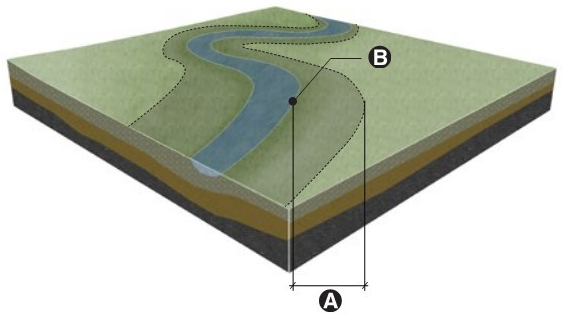
|
Stream Type (B) |
Riparian Management Zone (A) |
|---|---|
|
Type S (shoreline) |
See Division III of this title, Shoreline Code |
|
Type F (fish-bearing) |
200 feet |
|
Type Np (nonfish, perennial) |
120 feet |
|
Type Ns (nonfish, seasonal) |
70 feet |
L. The director may increase the standard riparian management zone width as necessary to fully protect riparian functions.
M. The director may reduce the standard riparian management zone in accordance with BLMC 16.20.130(H). The director may also reduce the riparian management zone by up to 25 percent wherever the proposed adjoining upland land use is of low intensity and low impact, such as passive use parks.
N. If the stream enters an underground culvert or pipe, and is unlikely to ever be restored above ground, the director may waive the riparian management zone along the undergrounded stream; provided, that where the stream enters and emerges from the pipe the opposite outer edges of the riparian management zone shall be joined by a radius equal to the riparian management zone width, with said radius projecting over the piped stream.
O. To the extent facilities are allowed in wildlife and fish habitat conservation areas, the following regulations shall apply:
1. Repealed by Ord. 1615.
2. Road bridges and culverts shall be designed according to the Washington Department of Fish and Wildlife “Water Crossing Design Guidelines,” 2013.
3. Utility lines shall be accomplished by boring beneath the riparian management zone, scour depth, and hyporheic zone. Utilities shall avoid paralleling streams.
4. Repealed by Ord. 1615.
5. In-stream structures such as high-flow bypasses, sediment ponds, in-stream ponds, retention and detention facilities, tide gates, dams, and weirs shall be allowed only as part of an approved restoration project.
6. Repealed by Ord. 1615.
7. Watercourse Alterations. See BLMC 16.26.040(F). (Ord. 1615 § 20, 2019; Ord. 1491 § 24, 2014; Ord. 1252 § 2, 2007; Ord. 1070 § 2, 2004).